Minta Farm Berwick S96A Transport Impact Assessment
|
|
|
- Norman Davis
- 6 years ago
- Views:
Transcription


1 Minta Farm Berwick S96A Transport Impact Assessment TIA001I-F 4 October 2017
2 onemilegrid ABN: (03) /59 Keele Street COLLINGWOOD, VIC DOCUMENT INFORMATION Prepared for Stockland Minta Farm File Name TIA001I-F Report Date 4 October 2017 Prepared by David Ballock Reviewed by Valentine Gnanakone Signature Signature One Mile Grid Pty Ltd. This document has been prepared by onemilegrid for the sole use and benefit of the client as per the terms of engagement. It may not be modified or altered, copied, reproduced, sold or transferred in whole or in part in any format to any person other than by agreement. onemilegrid does not assume responsibility or liability to any third party arising out of use or misuse of this document. Page 2
3 CONTENTS 1 INTRODUCTION EXISTING CONDITIONS Site Location Planning Zones Road Network SmartRoads Road User Hierarchy Maps MINTA FARM PRECINCT STRUCTURE PLAN (PSP) General Future Urban Structure DEVELOPMENT PROPOSAL General Access and Internal Road Network Soldiers Road Pedestrian and Bicycle Network RESIDENTIAL SUBDIVISION DESIGN Casey Planning Scheme Requirements Clause , Walking and cycling network objectives Clause , Public transport network objectives Clause , Neighbourhood street network objective Clause , Walking and cycling detail network objectives Clause , Public transport network detail objectives Clause , Neighbourhood street network detail objective Clause , Lot access objective TRAFFIC CONSIDERATIONS Overview Traffic Capacity Traffic Generation Traffic Distribution Traffic Impact CONCLUSIONS Page 3
4 TABLES Table 1 Road Cross Sections FIGURES Figure 1 Site Location... 5 Figure 2 Planning Scheme Zones... 6 Figure 3 Soldiers Road, looking south from the subject sites frontage... 7 Figure 4 SmartRoads Road User Hierarchy Map... 8 Figure 5 Locality Plan... 9 Figure 6 Draft Future Urban Structure Plan Figure 7 Proposed Subdivision Layout Figure 8 Proposed Roundabout Connection Figure 9 Internal Road Network Layout Figure 10 Road Cross Section Connector Street (Entrance Boulevard 31m) Figure 11 Road Cross Section Connector Street (31m) Figure 12 Road Cross Section Local Access Street Level 1 (16m) Figure 13 Soldiers Road Cross Section Figure 14 Pedestrian and Bicycle Network Page 4

5 1 INTRODUCTION onemilegrid has been requested by Stockland Minta Farm to undertake a Transport Impact Assessment of the proposed residential subdivision development at Soldiers Road, Berwick. A Section 96A application is being lodged for the subdivision of land located on the north side of Soldiers Road in Berwick as the Precinct Structure Plan for the development area is not yet completed. As part of this assessment the subject site has been inspected with due consideration of the development proposal, traffic data has been sourced and relevant background reports have been reviewed. 2 EXISTING CONDITIONS 2.1 Site Location The subject site is located on the north-eastern side of Soldiers Road between Chase Boulevard and Grices Road in Berwick, as shown in Figure 1. The application area is part of a larger parcel of land as shown in Figure 1 (indicated by the blue-dashed line), earmarked to be developed as a residential subdivision at later stages of the sites overall masterplan. The site is an irregularly shaped parcel of land, comprising an area of approximately 12.32ha and is currently vacant, generally consisting of grassland. Figure 1 Site Location Masterplan Area Subject Site Copyright Melway Publishing Land use in the vicinity of the site is largely rural in nature to the east and the south, whilst being largely residential to the west and south. Page 5

6 2.2 Planning Zones It is shown in Figure 2 that the site is located within an Urban Growth Zone (UGZ), for which the permitted uses are listed in Clause and Clause of the Casey Planning Scheme. Figure 2 Planning Scheme Zones Masterplan Area Subject Site Page 6

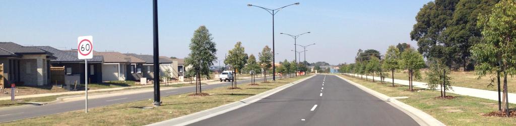
7 2.3 Road Network Soldiers Road is a local road running north from Thompsons Road in Clyde North to Adamson Road in Beaconsfield, where it continues as Kenilworth Avenue. In the vicinity of the site, Soldiers Road provides a single traffic lane in each direction with kerbside parallel parking lane on the southwest side only. Auxiliary turn lanes are provided at side roads to facilitate access. A photograph of Soldiers Road at the frontage of the site is shown in Figure 3. Figure 3 Soldiers Road, looking south from the subject sites frontage A 60km/h speed limit applies to Soldiers Road in the vicinity of the site. Page 7


8 2.4 SmartRoads Road User Hierarchy Maps In mid-2011 VicRoads developed the SmartRoads Road User Hierarchy Maps which aim to manage competing interests for limited road space by giving priority use of the road to different transport modes at particular times of the day. The SmartRoads map, reproduced in Figure 4, identifies the priority modes on each arterial road in the vicinity of the site, and indicates that Soldiers Road north of the site is a Future Bus Priority Route. Furthermore, Grices Road is noted as a Future Bus Priority Route. Figure 4 SmartRoads Road User Hierarchy Map Subject Site Page 8
")
9 3 MINTA FARM PRECINCT STRUCTURE PLAN (PSP) 3.1 General The site is located within the western portion of the Minta Farm PSP area, for which the City of Casey and State Government agencies, are currently preparing a Precinct Structure Plan (PSP) to facilitate the future development of the area. The Minta Farm Precinct has a total land area of approximately 286 hectares of land within the City of Casey and is around 45 kilometres south east of Melbourne s Central Business District. While the plan is still in development, at this stage it is anticipated to deliver approximately 3,000 dwellings and an employment precinct that supports approximately 10,000 jobs. Additionally, the plan is anticipated to deliver a key north south arterial road in the form of a boulevard which is to be an extension of Bells Road (to the south). It is anticipated that this road will ultimately connect into the Beaconsfield Interchange. The location of the PSP area and the subject site in the context of the surrounding area is provided in in Figure 5. Figure 5 Locality Plan Minta Farm PSP Area 96A Application 3.2 Future Urban Structure A draft of the future urban structure for the PSP area has been prepared by the VPA for the site which illustrates the general location of roads, land uses and other relevant elements of the PSP area. An extract of the urban structure is provided in Figure 6. As shown in the Future Urban Structure Plan, relevant to the application area and overall master plan, a Connector Street network is proposed from Soldiers Road linking through to the east and north with the future Bells Road arterial running north to south. Page 9

10 Figure 6 Draft Future Urban Structure Plan 96A Application Area Page 10

11 4 DEVELOPMENT PROPOSAL 4.1 General The application seeks to develop the subject site as part of the Minta Farm PSP for the purposes of a residential subdivision, comprising of approximately 231 standard residential lots (average lot size approximately 383m 2 ), passive open space and a road connection to Soldiers Road. The development is to be staged as follows: Stage lots, middle portion of site; Stage 2 41 lots, southeast portion of site; Stage 3 51 lots, northwest portion of site; and Stage 4 16 lots, middle portion of site. A view of the proposed site layout is shown in Figure 7 below. Figure 7 Proposed Subdivision Layout Page 11
12 Hazelnut Boulevard Connector Street 4.2 Access and Internal Road Network Access to the site is proposed to Soldiers Road approximately midway along the frontage forming a cross intersection with Hazelnut Boulevard to the south. As part of the development the existing T- intersection and associated turn lanes will be converted to a roundabout allowing fully direction movements in all directions. A VPA standard roundabout design as shown in Figure 8 below, reflecting a conceptual view of the proposed roundabout connection to Soldiers Road. Figure 8 Proposed Roundabout Connection Subject Site Subject Site Soldiers Road Pedestrian Crossing Across Soldiers Road Pedestrian Crossing Across Soldiers Road The Soldiers Road connection will comprise of a modified Connector Street 31 metre wide cross section to form a Boulevard in lieu of the standard Connector Street 25 metre wide cross section within the draft urban structure. From a traffic point of view there is no material difference between the two with the only change being the introduction of increased nature strip widths on both sides of the Connector Street. Additionally, the Connector Boulevard entry from Soldiers Road will be provided with a central median with a 6 metre width up until passing the first Local Access Street running perpendicular to the Connector Street. Within the site, the internal road network has been designed with standard Access Streets with 16 metre cross sections linking to the Connector Street network. A view of the proposed internal road network and road hierarchy of development is shown in Figure 9 and summarised in Table 1. Additionally, a view of the proposed cross sections is provided in Figure 10 to Figure 12. Speed control measures will be required to be implemented along roads exceeding 240m in length. It is recommended that threshold treatments be proposed at the location of T-intersections of such roads as an effective means of speed control. Pedestrian crossing opportunities will be available at the proposed roundabout at Hazelnut Boulevard and at Wurundjeri Boulevard through to the tree reserve (informal). Page 12
13 Figure 9 Internal Road Network Layout Connector Boulevard (31m) Connector Street (31m) Local Access Street A (16m) Laneway (8m) Site Access Pedestrian Crossing Opportunity Page 13
14 Table 1 Connector Street (Boulevard) Road Cross Sections Reservation Road Pavement Parking Footpath Bike Path Notes 31m 2 x 3.5m traffic lanes Connector Street 31m 2 x 3.5m traffic lanes Access Street 16m 7.3m pavement 2 x 2.1m kerbside indented bays 2 x 2.1m kerbside indented bays Intermittent onroad 2 x 1.5m footpath each side 2 x 1.5m footpath each side 2 x 1.5m footpath each side 3.0m off road path 3.0m off road path On-road - 6 metre wide median Widened nature strips It is considered that each of the above treatments provide the required traffic function when carrying traffic, and the required pedestrian and cycle function to cater for both cyclists and pedestrians. At road crossings, it is recommended that appropriate treatments are provided to ensure that priority is established as required. Page 14
 Page")
15 Figure 10 Road Cross Section Connector Street (Entrance Boulevard 31m) Page 15
 Page")
16 Figure 11 Road Cross Section Connector Street (31m) Page 16


17 Figure 12 Road Cross Section Local Access Street Level 1 (16m) 4.3 Soldiers Road As part of the development, Soldiers Road will be upgraded to provide for a parallel parking lane on the northeast side of the existing pavement effectively mirroring the southern arrangement. As a result, Soldiers Road will operate with a single traffic lane and a parallel parking lane in each direction as shown in Figure 13. Figure 13 Soldiers Road Cross Section Page 17

18 4.4 Pedestrian and Bicycle Network The proposed road network includes footpaths on both sides of all roads. The proposed access streets are designed to form a low speed and low traffic volume network, which can comfortably accommodate bicycle movements on-road within their cross-sections. In addition, the Connector Street includes a designated two-way bicycle path. The pedestrian and bicycle network is shown in Figure 14. Figure 14 Pedestrian and Bicycle Network Two-Way Off-Road Bicycle Path Pedestrian Footpath Page 18
19 5 RESIDENTIAL SUBDIVISION DESIGN 5.1 Casey Planning Scheme Requirements Clause identifies Access and Mobility Management requirements for residential subdivisions such as that proposed at the site. The following Clauses are applicable Clause , Walking and cycling network objectives Standard C15 The walking and cycling network should be designed to: Implement any relevant regional and local walking and cycling strategy, plan or policy for the area set out in this scheme. Link to any existing pedestrian and cycling networks. Provide safe walkable distances to activity centres, community facilities, public transport stops and public open spaces. Provide an interconnected and continuous network of safe, efficient and convenient footpaths, shared paths, cycle paths and cycle lanes based primarily on the network of arterial roads, neighbourhood streets and regional public open spaces. Provide direct cycling routes for regional journeys to major activity centres, community facilities, public transport and other regional activities and for regional recreational cycling. Ensure safe street and road crossings including the provision of traffic controls where required. Provide an appropriate level of priority for pedestrians and cyclists. Have natural surveillance along streets and from abutting dwellings and be designed for personal safety and security particularly at night. Be accessible to people with disabilities. The road network within the proposed subdivision is suitably designed to cater for and encourage both pedestrian and cyclist trips within and through the area. The internal road network has footpaths on both sides of each streets, and provision of a two-way off-road bicycle path along the Connector Street bisecting the site. Internal roads are expected to have minimal traffic volumes and low speeds, and are considered suitable for cyclists. All roads and paths are provided with natural surveillance. The proposed rear access laneways are short, with side abuttals to adjacent lots, enabling appropriate surveillance. It is therefore considered that the subdivision satisfies the objectives of Clause Clause , Public transport network objectives Standard C16 The public transport network should be designed to: Implement any relevant public transport strategy, plan or policy for the area set out in this scheme. Connect new public transport routes to existing and proposed routes to the satisfaction of the relevant public transport authority. Page 19
20 Provide for public transport links between activity centres and other locations that attract people using the Principal Public Transport Network in Metropolitan Melbourne and the regional public transport network outside Metropolitan Melbourne. Locate regional bus routes principally on arterial roads and locate local bus services principally on connector streets to provide: Safe and direct movement between activity centres without complicated turning manoeuvres. Direct travel between neighbourhoods and neighbourhood activity centres. A short and safe walk to a public transport stop from most dwellings. The proposed Connector Street bisecting the middle portion of the site running generally northwestsoutheast of the proposed development is designed to accommodate future public transport routes, ensuring that the entire development is situated within close proximity to public transport. Additionally, a potential bus route along Soldiers Road is proposed north of the site. It is therefore considered that the subdivision satisfies the objectives of Clause Clause , Neighbourhood street network objective Standard C17 The neighbourhood street network must: Take account of the existing mobility network of arterial roads, neighbourhood streets, cycle paths, cycle paths, footpaths and public transport routes. Provide clear physical distinctions between arterial roads and neighbourhood street types. Comply with the Roads Corporation s arterial road access management policies. Provide an appropriate speed environment and movement priority for the safe and easy movement of pedestrians and cyclists and for accessing public transport. Provide safe and efficient access to activity centres for commercial and freight vehicles. Provide safe and efficient access to all lots for service and emergency vehicles. Provide safe movement for all vehicles. Incorporate any necessary traffic control measures and traffic management infrastructure. The neighbourhood street network should be designed to: Implement any relevant transport strategy, plan or policy for the area set out in this scheme. Include arterial roads at intervals of approximately 1.6 kilometres that have adequate reservation widths to accommodate long term movement demand. Include connector streets approximately halfway between arterial roads and provide adequate reservation widths to accommodate long term movement demand. Ensure connector streets align between neighbourhoods for direct and efficient movement of pedestrians, cyclists, public transport and other motor vehicles. Provide an interconnected and continuous network of streets within and between neighbourhoods for use by pedestrians, cyclists, public transport and other vehicles. Provide an appropriate level of local traffic dispersal. Indicate the appropriate street type. Provide a speed environment that is appropriate to the street type. Provide a street environment that appropriately manages movement demand (volume, type and mix of pedestrians, cyclists, public transport and other motor vehicles). Encourage appropriate and safe pedestrian, cyclist and driver behaviour. Page 20
21 Provide safe sharing of access lanes and access places by pedestrians, cyclists and vehicles. Minimise the provision of culs-de-sac. Provide for service and emergency vehicles to safely turn at the end of a dead-end street. Facilitate solar orientation of lots. Facilitate the provision of the walking and cycling network, integrated water management systems, utilities and planting of trees. Contribute to the area s character and identity. Take account of any identified significant features. It is considered that the layout proposed and the cross section of internal roads is appropriate to promote safe and easy movement through the subdivision for all road users. Furthermore, the proposed road network will provide adequate clearances to cater for the access requirements of service and emergency vehicles (e.g. typically up to an 8.8m truck). The forecast daily traffic volumes for the internal subdivision roads will be well within the recommended volume limits specified in Table C1 of Clause To ensure speeds are controlled, street lengths are limited, and where longer streets are required, speed control devices are proposed to limit vehicle speeds. It is therefore considered that the subdivision generally satisfies the objectives of Clause Clause , Walking and cycling detail network objectives Standard C18 Footpaths, shared paths, cycle paths and cycle lanes should be designed to: Be part of a comprehensive design of the road or street reservation. Be continuous and connect. Provide for public transport stops, street crossings for pedestrians and cyclists and kerb crossovers for access to lots. Accommodate projected user volumes and mix. Meet the requirements of Table C1. Provide pavement edge, kerb, channel and crossover details that support safe travel for pedestrians, footpath bound vehicles and cyclists, perform required drainage functions and are structurally sound. Provide appropriate signage. Be constructed to allow access to lots without damage to the footpath or shared path surfaces. Be constructed with a durable, non-skid surface. Be of a quality and durability to ensure: Safe passage for pedestrians, cyclists, footpath bound vehicles and vehicles. Discharge of urban run-off. Preservation of all-weather access. Maintenance of a reasonable, comfortable riding quality. A minimum 20 year life span. Be accessible to people with disabilities and include tactile ground surface indicators, audible signals and kerb ramps required for the movement of people with disabilities. The proposed road network and footpath provision provide continuous pedestrian connectivity and are to be designed appropriately to meet drainage, durability and access requirements. No cycle paths are to be provided on the local access streets as carriageways will be designed as a shared zone. Page 21
22 The two-way off-road bicycle path provided along the Connector Street throughout the site will provide north-to-south permeability for cyclists throughout the site. Otherwise, cyclists will be accommodated on-street, where street lengths and speed control devices will ensure that vehicle speeds are limited It is therefore considered that the subdivision satisfies the objectives of Clause Clause , Public transport network detail objectives Standard C19 Bus priority measures must be provided along arterial roads forming part of the existing or proposed Principal Public Transport Network in Metropolitan Melbourne and the regional public transport network outside Metropolitan Melbourne to the requirements of the relevant roads authority. Road alignment and geometry along bus routes should provide for the efficient, unimpeded movement of buses and the safety and comfort of passengers. The design of public transport stops should not impede the movement of pedestrians. Bus and tram stops should have: Surveillance from streets and adjacent lots. Safe street crossing conditions for pedestrians and cyclists. Safe pedestrian crossings on arterial roads and at schools including the provision of traffic controls as required by the roads authority. Continuous hard pavement from the footpath to the kerb. Sufficient lighting and paved, sheltered waiting areas for forecast user volume at neighbourhood centres, schools and other locations with expected high patronage. Appropriate signage. The proposed Connector Street bisecting the middle portion of the site and Soldiers Road north of the site, have been designed to cater for a public transport route,, therefore the requirements of Clause do not apply Clause , Neighbourhood street network detail objective Standard C20 The design of streets and roads should: Meet the requirements of Table C1. Where the widths of access lanes, access places, and access streets do not comply with the requirements of Table C1, the requirements of the relevant fire authority and roads authority must be met. Provide street blocks that are generally between 120 metres and 240 metres in length and generally between 60 metres to 120 metres in width to facilitate pedestrian movement and control traffic speed. Have verges of sufficient width to accommodate footpaths, shared paths, cycle paths, integrated water management, street tree planting, lighting and utility needs. Have street geometry appropriate to the street type and function, the physical land characteristics and achieve a safe environment for all users. Provide a low-speed environment while allowing all road users to proceed without unreasonable inconvenience or delay. Provide a safe environment for all street users applying speed control measures where appropriate. Page 22
23 Ensure intersection layouts clearly indicate the travel path and priority of movement for pedestrians, cyclists and vehicles. Provide a minimum 5 metre by 5 metre corner splay at junctions with arterial roads and a minimum 3 metre by 3 metre corner splay at other junctions unless site conditions justify a variation to achieve safe sight lines across corners. Ensure streets are of sufficient strength to: Enable the carriage of vehicles. Avoid damage by construction vehicles and equipment. Ensure street pavements are of sufficient quality and durability for the: Safe passage of pedestrians, cyclists and vehicles. Discharge of urban run-off. Preservation of all-weather access and maintenance of a reasonable, comfortable riding quality. Ensure carriageways of planned arterial roads are designed to the requirements of the relevant road authority. Ensure carriageways of neighbourhood streets are designed for a minimum 20 year life span. Provide pavement edges, kerbs, channel and crossover details designed to: Perform the required integrated water management functions. Delineate the edge of the carriageway for all street users. Provide efficient and comfortable access to abutting lots at appropriate locations. Contribute to streetscape design. Provide for the safe and efficient collection of waste and recycling materials from lots. Be accessible to people with disabilities. Meet the requirements of Table C1. Where the widths of access lanes, access places, and access streets do not comply with the requirements of Table C1, the requirements of the relevant fire authority and roads authority must be met. Where the widths of connector streets do not comply with the requirements of Table C1, the requirements of the relevant public transport authority must be met. A street detail plan should be prepared that shows, as appropriate: The street hierarchy and typical cross-sections for all street types. Location of carriageway pavement, parking, bus stops, kerbs, crossovers, footpaths, tactile surface indicators, cycle paths and speed control and traffic management devices. Water sensitive urban design features. Location and species of proposed street trees and other vegetation. Location of existing vegetation to be retained and proposed treatment to ensure its health. Any relevant details for the design and location of street furniture, lighting, seats, bus stops, telephone boxes and mailboxes. Road cross-sections are generally in accordance with Table C1 of the Planning Scheme, as discussed in Section 4. It is therefore considered that the subdivision satisfies the objectives of Clause Page 23
24 5.1.7 Clause , Lot access objective Standard C21 Vehicle access to lots abutting arterial roads should be provided from service roads, side or rear access lanes, access places or access streets where appropriate and in accordance with the access management requirements of the relevant roads authority. Vehicle access to lots of 300 square metres or less in area and lots with a frontage of 7.5 metres or less should be provided via rear or side access lanes, places or streets. The design and construction of a crossover should meet the requirements of the relevant road authority. Generally, all internal single dwelling lots will have direct access onto the proposed internal road network via conventional crossovers. Rear-access lanes are provided to a number of lots fronting the Connector Street entrance from Soldiers Road to the site, due to the lots having less than 10.5 metres minimum frontage width and 300m 2 in size. It is therefore considered that the subdivision satisfies the objectives of Clause Page 24
25 6 TRAFFIC CONSIDERATIONS 6.1 Overview The traffic generated by the proposed development has been assessed by various traffic reports prepared on behalf of the VPA by other consultants to model the impact of development of the PSP area and surrounding areas on the road network. These reports have assessed the existing road network as well as provided direction on the future road network, including intersections, arterial road connections, and road cross sections. In light of the above, the traffic generated by the development has already been assessed and considered acceptable. Notwithstanding, to provide a robust assessment the development s traffic impact has been assessed as follows. 6.2 Traffic Capacity Connector Streets have an indicative road capacity up to 7,000 vehicles per day. Soldiers Road is considered to be a Connector Street standard and as such it would have a capacity for up to 7,000 vehicles per day. Review on-site indicates that the section of Soldiers Road along the frontage of the site is currently carrying 2,000 vehicles per day. 6.3 Traffic Generation It is generally accepted that single dwellings on a lot in outer suburban areas may generate traffic at up to 10 vehicles per day, whilst in areas with good public transport, and for higher density dwellings, lower traffic generation rates are often recorded. Considering the size of the lots proposed and the proximity of the site to public transport, it is anticipated that the proposed development may initially generate up to 9 vehicle trips per day per lot. Application of the above traffic generation rates to the proposed 231 lot development is expected to initially generate up to approximately 2,079 vehicle trips per day, and approximately 208 vehicle trips per hour during both the AM and PM peak. 6.4 Traffic Distribution The first stages of development subject to this application will utilise the single connection to Soldiers Road. As development continues to the northeast further connections will be available to the surrounding road network and in particular the future Bells Road arterial and other Connect Street connections. Given the subject site is expected to be developed prior to any additionally external connections being provided, it is projected that all of the 2,079 daily traffic movements will be distributed to Soldiers Road via the proposed Connector Street connection. Of that traffic, it will be assumed that 70% is distributed to the northwest and 30% to the southeast based on likely destinations and attractions. Page 25
26 6.5 Traffic Impact Based on the projected distribution of traffic, it is projected that 1,455 vehicle movements will be generated to the northwest and 624 movements to the southeast per day. This level of additional traffic is well within the capacity of Soldiers Road and is expected to be easily assimilated by the existing and proposed road network. With regard to the proposed roundabout at the Connector Street intersection with Soldiers Road and Hazelnut Boulevard, as previously shown in Figure 8, it is expected that the peak hour generation of 208 vehicle movements per hour can be suitably accommodated and again is well within the capacity of such a roundabout with sufficient capacity to accommodate further traffic as required. Considering the above analysis, it is expected that the existing and proposed local street network will have sufficient capacity to accommodate the interim stages of development until such time that additional road connections are provided by further developments to the north and east. Page 26
27 7 CONCLUSIONS It is proposed to develop the subject site for the purposes of a 231 lot residential subdivision. Considering the analysis presented above, it is concluded that: The design of the proposed subdivision generally accords with the requirements of the Casey Planning Scheme, VPA Subdivision Design Standards; The proposed internal road network and connections to Soldiers Road are expected to be suitable to accommodate the proposed development traffic generation. Page 27
PROPOSED RESIDENTIAL SUBDIVISION
 PROPOSED RESIDENTIAL SUBDIVISION PART OF TARNEIT ROAD & 1121 DOHERTYS ROAD, TARNEIT Prepared For: TCG (RM) Developments Pty Ltd MARCH 2014 OUR REF: 16740R#1 PROPOSED RESIDENTIAL SUBDIVISION PART OF TARNEIT
DESIGN CODE. Enterprise West Harlow London Road North Design Code 21
 DESIGN CODE Enterprise West Essex @ Harlow London Road North Design Code 21 4 MAXIMUM BUILDING HEIGHTS 4.1 Table 4A sets out maximum building height standards for each character area within the LDO boundary.
Traffic and Transport Assessment
 Traffic and Transport Assessment Section 96 Residential Subdivision, Davis Road Tarneit CG120370 Prepared for Stockland Pty Ltd 19 February 2013 Document Information Prepared for Stockland Pty Ltd Project
Minta Farm Precinct Structure Plan
 Minta Farm Precinct Structure Plan Concept Road Design Report Client: Victorian Planning Authority Project No. 161910 Final Report 05/10/17 1 st Floor 132 Upper Heidelberg Road Ivanhoe Vic 3079 PO Box
STATEMENT TO PLANNING PANELS VICTORIA BY WILLIAM DE WAARD, TRAFFIC ENGINEER
 Amendment C228 to the Casey Planning Scheme Traffic Engineering Assessment Planning Panels Victoria Panel Hearing Date: Monday 16 th April, 2018 Report Date: 5 th April, 2018 Prepared for the Applicant:
Classification Criteria
 SCHEDULE D TO RECOMMENDED OFFICIAL PLAN AMENDMENT NO. 40 SCHEDULE C-4 Road Criteria Criteria Traffic Service Objective Land Service/Access Typical Daily Traffic Volume Flow characteristics Travel Speed
Berwick Health and Education Precinct: Casey Amendment C207 (Part 1) Submission to Planning Panels Victoria
 Submission to Planning Panels Victoria") Berwick Health and Education Precinct: Casey Amendment C207 (Part 1) Submission to Planning Panels Victoria August 2018 CONTENTS 1 Executive summary... 1 2 Summary of the amendment... 2 3 Submission...
Berwick Health and Education Precinct: Casey Amendment C207 (Part 1) Submission to Planning Panels Victoria August 2018 CONTENTS 1 Executive summary... 1 2 Summary of the amendment... 2 3 Submission...
Liveable Neighbourhoods Design Code and Policy
 CNU London Transportation Summit, November 2007 The West Australian Liveable Neighbourhoods Design Code and Policy Incorporating a New Urbanist Street Design Manual for New Communities Wendy Morris Ecologically
BROMPTON LODGE, CRANBOURNE PRECINCT STRUCTURE PLAN TRAFFIC ENGINEERING ASSESSMENT WOLFDENE PTY LTD PREPARED FOR
 BROMPTON LODGE, CRANBOURNE PRECINCT STRUCTURE PLAN TRAFFIC ENGINEERING ASSESSMENT PREPARED FOR WOLFDENE PTY LTD TRAFFIC ENGINEERING ASSESSMENT PRECINCT STRUCTURE PLAN AT BROMPTON LODGE, CRANBOURNE Document
Transit boulevard: A new road type for Sydney s Growth Centres
 Transit boulevard: A new road type for Sydney s Growth Centres Cleaver, M. A., de Roos, M. P., NSW Centre for Road Safety, Roads and Traffic Authority, NSW Collins, G., Network Services, Roads and Traffic
1 VicRoads Access Management Policies May 2006 Ver VicRoads Access Management Policies May 2006 Version 1.02
 1 VicRoads Access Management Policies May 2006 Ver 1.02 VicRoads Access Management Policies May 2006 Version 1.02 2 VicRoads Access Management Policies May 2006 Ver 1.02 FOREWORD FOR ACCESS MANAGEMENT
21.07 TRANSPORT CONNECTIVITY AND INFRASTRUCTURE
 21.07 TRANSPORT CONNECTIVITY AND INFRASTRUCTURE 21.07-1 Connectivity and Choice Transport connectivity and mode choice are critical to achieving productive, sustainable and socially just cities. Travel
Strategy for Walking & Cycling Action Plan
 Strategy for Walking & Cycling Action Plan To achieve higher levels of walking and cycling activity, the destinations which people access have to be available within suitable distances and designed to
Traffic Engineering Assessment. Additional Traffic Modelling at Minta Farm PSP 11. Prepared for Victorian Planning Authority
 Additional Traffic Modelling at Minta Farm PSP 11 Prepared for Victorian Planning Authority Traffic Engineering Assessment Additional Traffic Modelling at Minta Farm PSP 11 Document Control Issue No. Type
Daleston Masterplan Traffic & Transport Assessment
 ` Daleston Masterplan Job Number: CG111723 Daleston Masterplan Cardno Victoria Pty Ltd ABN 47 106 610 913 150 Oxford Street, Collingwood Victoria 3066 Australia Telephone: 03 8415 7777 Facsimile: 03 8415
10 SHERFORD Town Code
 Key Fixes (Ref: Masterplan Book, section 4a. Land Use Budget and Key Fixes ) The Town Plan designs and allocates buildings, streets and spaces as accurately as possible in the understandable absence of
4.1 Introduction. 4.2 Aspects of walkable communities
 4 Community walkability Community walkability Making communities walkable Urban form Feeling secure 4.1 Introduction Walkability describes the extent to which the built environment is walking-friendly.
Sixth Line Development - Transit Facilities Plan
 Memorandum Date: November 13, 2012 To: From: c.c. Subject: Rob Freeman (Freeman Planning) Kevin Phillips Sixth Line Development - Transit Facilities Plan 33016631 This memo was prepared to review the transit
PLAN 20 PUBLIC TRANSPORT NETWORK
 KEY Bus Route / 400m Coverage Existing Recommended Secondary Potential Secondary Indicative Stop Locations Principle Standard Sub-regional Transit Corridor Reservation PLAN 0 PUBLIC TRANSPORT NETWORK Date:
NM-POLICY 1: Improve service levels, participation, and options for non-motorized transportation modes throughout the County.
 Transportation PRINCE WILLIAM COUNTY 2008 COMPREHENSIVE PLAN NON-MOTORIZED PLAN CONTENTS Goals, Policies, and Action Strategies Table 4 (Bike Facility Classifications and Descriptions) Table 5 (Bike Facility
CITY OF SASKATOON COUNCIL POLICY
 ORIGIN/AUTHORITY Clause 1, Report No. 1-1980 and Clause 4, Report No. 22-1990 of the Works and Utilities Committee; Clause 6, Report No. 17-2004 of the Planning and Operations Committee; and Clause D5,
Prepared For: Shieldbay Developments Inc. c/o Matson, McConnell Ltd. 2430A Bloor Street West Toronto, Ontario M6S 1P9.
 Prepared For: Shieldbay Developments Inc. c/o Matson, McConnell Ltd. 2430A Bloor Street West Toronto, Ontario M6S 1P9 Prepared By: URS Canada Inc. 4 th Floor, 30 Leek Crescent Richmond Hill, Ontario L4B
Barwon Heads Road, Armstrong Creek Traffic Impact Assessment Prepared for: Newland Developers Pty Ltd
 892 990 Barwon Heads Road, Armstrong Creek Traffic Impact Assessment Prepared for: Newland Developers Pty Ltd JULY 2015 TABLE OF CONTENTS 1 INTRODUCTION... 1 1.1 BACKGROUND... 1 1.2 SCOPE... 1 1.3 AIM
Recommended Roadway Plan Section 2 - Land Development and Roadway Access
 Recommended Roadway Plan Section 2 - Land Development and Roadway Access SECTION 2 Land Development and Roadway Access 2.1 Land Use and Access Management The Federal Highway Administration (FHWA) defines
Roadway Classification Design Standards and Policies. Pueblo, Colorado November, 2004
 Roadway Classification Design Standards and Policies Pueblo, Colorado November, 2004 Table of Contents Page Chapter 1. General Provisions 1.1 Jurisdiction 3 1.2 Purpose and Intent 3 1.3 Modification 3
TGSI Tactile Ground Surface Indicators
 TGSI Tactile Ground Surface Indicators Introduction: This Design Note, No 11, provides guidelines and requirements for the use and installation of Tactile Ground Surface Indicators (TGSI s). References
TRANSPORT AND MOVEMENT
 TRANSPORT AND MOVEMENT Movement Strategy Public Transport Cycling and Walking Road Network Parking Standards Transport Impact Assessments Traffic Management Policies DRAFT POOLBEG PLANNING SCHEME Movement
Ormond & McKinnon Walks Response to Draft Glen Eira Community Plan
 Response to Draft Glen Eira Community Plan We would like to take this opportunity to thank Glen Eira City Council for the opportunity to comment on the Glen Eira Draft Community Plan. Below is an outline
Part B Design Guidance / Principles _
 Part B Design Guidance / Principles www. landlab.co.nz Queenstown Town Centre Public Realm Design Guidelines Version 7 14 June 2018 Page 006 B1 Design Guidance & Best Practice The Queenstown Town Centre
Proposed Residential & Retail Development at Geelong Rd Portarlington
 Batman Invest Traffic Impact Assessment Proposed Residential & Retail Development at 30-32 Geelong Rd Portarlington Batman Invest Traffic & Parking Impact Assessment for Proposed Residential & Retail Development
TRAVEL PLAN: CENTRAL EUROPEAN UNIVERSITY CAMPUS REDEVELOPMENT PROJECT TRAVEL PLAN. Central European University Campus Redevelopment Project.
 TRAVEL PLAN Central European University Campus Redevelopment Project Page 1 Table of Contents Introduction... 3 Background... 7 Building Users... 7 Transportation in Community Consultation... 7 Summary
Having held a public hearing, that Council approve:
 3. MODIFICATIONS TO MERIVALE ROAD FROM FALLOWFIELD ROAD TO OLD HIGHWAY 16 TO ACCOMMODATE THE GROWTH WITHIN THE SOUTH MERIVALE BUSINESS PARK - PUBLIC HEARING COMMITTEE RECOMMENDATIONS Having held a public
City of Wayzata Comprehensive Plan 2030 Transportation Chapter: Appendix A
 A1. Functional Classification Table A-1 illustrates the Metropolitan Council s detailed criteria established for the functional classification of roadways within the Twin Cities Metropolitan Area. Table
CITY OF VAUGHAN EXTRACT FROM COUNCIL MEETING MINUTES OF OCTOBER 30, 2012
 CITY OF VAUGHAN EXTRACT FROM COUNCIL MEETING MINUTES OF OCTOBER 30, 2012 Item 31, Report No. 39, of the Committee of the Whole, which was adopted without amendment by the Council of the City of Vaughan
DUNBOW ROAD FUNCTIONAL PLANNING
 DUNBOW ROAD FUNCTIONAL PLANNING Final Report August 3, 216 #31, 316 5th Avenue NE Calgary, AB T2A 6K4 Phone: 43.273.91 Fax: 43.273.344 wattconsultinggroup.com Dunbow Road Functional Planning Final Report
Appendix 12 Parking on footways and verges
 Appendix 12 Parking on footways and verges Legal position Parking on footways and verges whether wholly or partly is banned throughout London, unless signs are placed to allow parking. The ban requires
IMPLEMENTATION. PEDESTRIAN USERS (Continued /) A: Class 2 Pedestrian / Cycle Ways. Pedestrian and Cycle Ways:
 A: Class 2 Pedestrian / Cycle Ways. Pedestrian and Cycle Ways:") A: Class 2 Pedestrian / Cycle Ways PLAN VIEW Pedestrian and Cycle Ways: Layout and Geometry (Refer to A): Walkways and cycle to be provided adjacent to all Class 2 Roads (these facilities should always
A: Class 2 Pedestrian / Cycle Ways PLAN VIEW Pedestrian and Cycle Ways: Layout and Geometry (Refer to A): Walkways and cycle to be provided adjacent to all Class 2 Roads (these facilities should always
TRANSPORTATION NEEDS ASSESSMENT
 TRANSPORTATION NEEDS ASSESSMENT A travel demand analysis was carried out to determine the operational issues and the potential benefit that adding traffic capacity would have on the road network. All the
St Germain Special Activity Precinct 1425 Pound Road & 2100 Thompsons Road Clyde North Transport Impact Assessment
 St Germain Special Activity Precinct 1425 Pound Road & 2100 Thompsons Road Clyde North Transport Impact Assessment St Germain Special Activity Precinct 1425 Pound Road & 2100 Thompsons Road, Clyde North
Frome Street Bicycle Route
 The Adelaide City Council invites engagement from the community about Frome Street Bicycle Route Project Summary Adelaide City Council is seeking feedback on design options to construct bicycle facilities
Active Transportation Infrastructure Investment A Business Case
 Active Transportation Infrastructure Investment A Business Case In 2016, the Real Estate Foundation awarded the Capital Regional District a $50,000 grant for Shifting Gears: Land Use Change through Active
Improving Cyclist Safety at the Dundas Street West and Sterling Road Intersection
 STAFF REPORT ACTION REQUIRED Improving Cyclist Safety at the Dundas Street West and Sterling Road Intersection Date: August 17, 2012 To: From: Wards: Reference Number: Public Works and Infrastructure Committee
DRAFT for a State Policy for Healthy Spaces and Places
 DRAFT for a State Policy for Healthy Spaces and Places 1 DRAFT State Policy for Healthy spaces and Places 1. Purpose To encourage the use and development of land that builds healthy communities through
4. ENVIRONMENTAL IMPACT ANALYSIS 9. TRANSPORTATION AND TRAFFIC
 4. ENVIRONMENTAL IMPACT ANALYSIS 9. TRANSPORTATION AND TRAFFIC 4.9.1 INTRODUCTION The following section addresses the Proposed Project s impact on transportation and traffic based on the Traffic Study
West Dimond Blvd Upgrade Jodhpur Street to Sand Lake Road
 West Dimond Blvd Jodhpur St to Sand Lake CSS Transportation Project Summary Municipality of Anchorage Project # 05 005 Project Manager: John Smith, P.E. (MOA PM&E) Project Administrator: Julie Makela,
13M /09/13. St Germain Special Activity Precinct 1425 Pound Road & 2100 Thompsons Road Clyde North Transport Impact Assessment.
 St Germain Special Activity Precinct 1425 Pound Road & 2100 Thompsons Road Clyde North Transport Impact Assessment d r a f t TIA/RSAMA VIC (130603 v7.2)) St Germain Special Activity Precinct 1425 Pound
Exhibit 1 PLANNING COMMISSION AGENDA ITEM
 Exhibit 1 PLANNING COMMISSION AGENDA ITEM Project Name: Grand Junction Circulation Plan Grand Junction Complete Streets Policy Applicant: City of Grand Junction Representative: David Thornton Address:
CURBSIDE ACTIVITY DESIGN
 5 CURBSIDE ACTIVITY DESIGN This chapter provides design guidance for separated bike lanes adjacent to curbside activities including parking, loading and bus stops. Typical configurations are presented
CURRENT ORIGINAL REFERENCE SECTIONS. (Typical Section) (Typical Section) The Parade Island Bay : Concept Option Summary Sheets.
 (Typical Section) The Parade Island Bay : Concept Option Summary Sheets.") ORIGINAL (Typical Section) CURRENT (Typical Section) 3,900 3,000 2,000 1,500 3,100 1,600 3,100 1,500 2,000 2,500 3,900 3,000 1,800 600 2,000 3,000 3,000 2,000 600 1,800 2,500 Existing Planting Traffic
ORIGINAL (Typical Section) CURRENT (Typical Section) 3,900 3,000 2,000 1,500 3,100 1,600 3,100 1,500 2,000 2,500 3,900 3,000 1,800 600 2,000 3,000 3,000 2,000 600 1,800 2,500 Existing Planting Traffic
4 DISRUPTION MANAGEMENT PLAN HIGHWAY 7 RAPIDWAY CONSTRUCTION BETWEEN BAYVIEW AVENUE AND WARDEN AVENUE TOWNS OF MARKHAM AND RICHMOND HILL
 4 DISRUPTION MANAGEMENT PLAN HIGHWAY 7 RAPIDWAY CONSTRUCTION BETWEEN BAYVIEW AVENUE AND WARDEN AVENUE TOWNS OF MARKHAM AND RICHMOND HILL The Transportation Services Committee recommends the adoption of
Complete Streets. Designing Streets for Everyone. Sarnia
 Complete Streets Designing Streets for Everyone Sarnia Complete Streets ~ Sarnia ~ 2018 Introduction Our City is made up of a network of streets that we use to go for a walk, cycle to work, drive to the
Non-Motorized Transportation 7-1
 Non-Motorized Transportation 7-1 Transportation facilities no longer mean just accommodating a vehicle powered by a combustion engine. Pedestrian and non-motorized facilities are important modes of travel
IMPLEMENTATION GUIDELINE NO. 13
 IMPLEMENTATION GUIDELINE NO. 13 Provision of Electricity, Driveways and Crossovers, Footpaths, Kerb and Channel Date of Council Resolution These guidelines were adopted by Council on 13 October 2009, and
City of Ottawa s Complete Streets Approach to Transportation Projects
 City of Ottawa s Complete Streets Approach to Transportation Projects Presentation to Stakeholders Date: May 5, 2015 Presentation Overview Purpose of the study Proposed definition of Complete Streets for
IMPLEMENTATION. PEDESTRIAN USERS (Continued /) Building Frontages: A: Stair Applications. Geometry (Accessed from the Sidewalk) Refer to A:
 Building Frontages: A: Stair Applications. Geometry (Accessed from the Sidewalk) Refer to A:") A: Stair Applications Building Frontages: Geometry (Accessed from the Sidewalk) Refer to A: Ramps should be provided for disabled users at 1:12 (8.3%) gradient. Ramp rises should be stepped at 400mm intervals.
A: Stair Applications Building Frontages: Geometry (Accessed from the Sidewalk) Refer to A: Ramps should be provided for disabled users at 1:12 (8.3%) gradient. Ramp rises should be stepped at 400mm intervals.
APPENDIX G: INTERSECTION NEEDS AT OKEECHOBEE BOULEVARD
 APPENDIX G: INTERSECTION NEEDS AT OKEECHOBEE BOULEVARD INTERSECTION NEEDS AT SR 7 and OKEECHOBEE BOULEVARD SR 7 Extension Project Development and Environment (PD&E) Study From Okeechobee Boulevard (SR
WELCOME TO OPEN HOUSE # 1 June 14, 2017
 Langstaff Road Weston Road to Highway 7 Class Environmental Assessment Study WELCOME TO OPEN HOUSE # 1 June 14, 2017 Please sign in and join our mailing list Purpose of Open House #1 & Study Area York
APPENDIX E Needs Assessment
 APPENDIX E Needs Assessment Active Transportation Needs Assessment Technical Background This appendix provides the technical background supporting the findings presented in Section 3 of the report. Developed
March Maidstone Integrated Transport Strategy Boxley Parish Council Briefing Note. Context. Author: Parish Clerk 2 March 2016
 Context. Author: Parish Clerk 2 The Draft Integrated Transport Policy (DITS) sets out a vision and objectives, and identifies a detailed programme of interventions to support the Maidstone Borough Local
SLOUGH Stage 3 Road Safety Audit of A4 London Road, M4 J5 to Sutton Lane
 SLOUGH Stage 3 Road Safety Audit of A4 London Road, M4 J5 to Sutton Lane Exception Report Client Officer Rudo Beremauro Date 20 January 2015 RSA /Project Sponsor s Contents Section 3 Project Sponsor's
RAA Submission to: The City of Adelaide Draft Integrated Movement Strategy Moving Adelaide
 RAA Submission to: The City of Adelaide Draft Integrated Movement Strategy 2012-22 Moving Adelaide May 2012 RAA Submission to the City of Adelaide Draft Integrated Movement Strategy 2012-22 Moving Adelaide
IAN WHITE ASSOCIATES. Crawley Station Gateway Public Realm
 IAN WHITE ASSOCIATES Crawley Station Gateway Public Realm contents 1. objectives & client brief 2. site appraisal 3. best practice guidance 4. design concept 1. objectives & client brief Crawley Train
Manukau City Council Plan Change 20 - Flatbush Stage 2. Integrated Transport Assessment (ITA)
") Manukau City Council Plan Change 20 - Flatbush Stage 2 Integrated Transport Assessment (ITA) October 2010 Flatbush Stage 2 Integrated Transport Assessment 51/28971/01/Flatbush ITA_V01.doc Contents 1. Introduction
Manukau City Council Plan Change 20 - Flatbush Stage 2 Integrated Transport Assessment (ITA) October 2010 Flatbush Stage 2 Integrated Transport Assessment 51/28971/01/Flatbush ITA_V01.doc Contents 1. Introduction
Cycle Track Design Best Practices Cycle Track Sections
 Design Best Practices Sections It is along street segments where the separation and protection methods of cycle tracks offer more comfort than conventional bicycle lanes, and are more attractive to a wide
Frascati Road and Temple Hill Route Improvements. Outline Design Report to Accompany Public consultation
 Frascati Road and Temple Hill Route Improvements Outline Design Report to Accompany Public consultation September 2013 Background: Dún Laoghaire-Rathdown is committed to providing high quality pedestrian
PennDOT Access Management Model Ordinances Training
 PennDOT Access s Training Trainers: Chad Dixson, AICP, TPD Angela Watson, PB Objective of Today Assist Pennsylvania s municipalities and transportation professionals in better understanding the benefits
complete streets design and construction standards public primer City of Edmonton
 complete streets design and construction standards public primer City of Edmonton introduction Complete Streets are streets for everyone: people who walk, wheel, bike, take transit, or drive. They are
TRAFFIC CALMING GUIDE FOR TORONTO CITY OF TORONTO TRANSPORTATION SERVICES DIVISION
 TRAFFIC CALMING GUIDE FOR TORONTO CITY OF TORONTO TRANSPORTATION SERVICES DIVISION CITY OF TORONTO TRANSPORTATION SERVICES DIVISION 2016 TRAFFIC CALMING GUIDE FOR TORONTO TABLE OF CONTENTS Introduction
CHECKLIST 2: PRELIMINARY DESIGN STAGE AUDIT
 CHECKLIST 2: PRELIMINARY DESIGN STAGE AUDIT 2.1 General topics 2.1.1 Changes since previous audit Do the conditions for which the scheme was originally designed still apply? (for example, no changes to
MUTCD Part 6G: Type of Temporary Traffic Control Zone Activities
 MUTCD Part 6G: Type of Temporary Traffic Control Zone Activities 6G.01 Typical Applications Each temporary traffic control (TTC) zone is different. Many variables, such as location of work, highway type,
Traffic Modelling and Intersection Analysis
 City of Whittlesea 4-Sep-4 Traffic Modelling and Intersection Analysis Wollert Precinct Structure Plan \\aumelfp\projects\698\6. Draft Docs\6. Reports\4-9-4 Final Report.docx Revision 4-Sep-4 Prepared
Basalt Creek Transportation Refinement Plan Recommendations
 Basalt Creek Transportation Refinement Plan Recommendations Introduction The Basalt Creek transportation planning effort analyzed future transportation conditions and evaluated alternative strategies for
Chapter 5 Future Transportation
 Chapter 5 Future Transportation The Future Land Use Plan identifies the desired land use designations. The land uses desired for Crozet depend, in large part, on the success of the transportation system,
El Centro Mobility Hub
 The El Centro drive shed comprises a major portion of the El Centro downtown area, which is well served by bus routes. The proposals intend to promote use of public transit through improvements and enhancements
Ministry of Education Flat Bush School Notice of Requirement. Integrated Transportation Assessment Report. February 2016
 Ministry of Education Flat Bush School Notice of Requirement Integrated Transportation Assessment Report February 2016 TDG Ref: 12988-2 151105 ita flat bush.docx Ministry of Education Flat Bush School
BETHEL ROAD AND SEDGWICK ROAD CORRIDOR STUDY
 DRAFT PLAN City Council Meeting August 14, 2017 STUDY AREA Sedgwick Corridor State Route 160, principal arterial with Class 3 access management designation, commuter and freight route, connection to SR
TS 109 DURHAM ROAD QTC PHASE 4 PROJECT PROPOSAL. Page 1
 TS 109 DURHAM ROAD QTC PHASE 4 PROJECT PROPOSAL Page 1 Table of Contents 1.0 Introduction... 3 2.0 Project Overview... 3 3.0 Project Proposals... 4 3.1 Enfield Road / Durham Road Junction... 3 5 3.2 Summerfield
Public Consultation on Braintree Integrated Transport Package (ITP) HAVE YOUR. Consultation open from 24 September to 5 November 2018 SAY
 HAVE YOUR. Consultation open from 24 September to 5 November 2018 SAY") Public Consultation on Braintree Integrated Transport Package (ITP) HAVE YOUR SAY Consultation open from 24 September to 5 November 2018 Contents Introduction 3 Background 4 Springwood Drive Roundabout
Public Consultation on Braintree Integrated Transport Package (ITP) HAVE YOUR SAY Consultation open from 24 September to 5 November 2018 Contents Introduction 3 Background 4 Springwood Drive Roundabout
CITY OF COCOA BEACH 2025 COMPREHENSIVE PLAN. Section VIII Mobility Element Goals, Objectives, and Policies
 CITY OF COCOA BEACH 2025 COMPREHENSIVE PLAN Section VIII Mobility Element Goals, Objectives, and Policies Adopted August 6, 2015 by Ordinance No. 1591 VIII MOBILITY ELEMENT Table of Contents Page Number
The Safe System Approach
 There are very few areas of public discussion and sentiment which generate as much consensus as road safety. Everyone wants safer roads for all users, and road safety is a key priority for governments,
EXECUTIVE SUMMARY: TRANSIT-ORIENTED DEVELOPMENT IN SMITHS FALLS, ONTARIO; A COMPARISON BETWEEN TWO SITES
 EECUTIVE SUMMARY: TRANSIT-ORIENTED DEVELOPMENT IN SMITHS FALLS, ONTARIO; A COMPARISON BETWEEN TWO SITES Topic and Purpose In 2007, the Mayor of Ottawa s Task Force on Transportation suggested adding a
CONTEXT SENSITIVE STREETS STANDARDS COMMITTEE
 CONTEXT SENSITIVE STREETS STANDARDS COMMITTEE February 23, 2015 Prepared by: Denise Chaplick, AICP City Jacksonville Bicycle and Pedestrian Coordinator Source: NCDOT Complete Streets Planning and Design
Welcome. If you have any questions or comments on the project, please contact:
 Welcome This drop-in public open house is intended to provide information about the Bay Street bike lanes project. This project proposes a dedicated cycling facility along Bay Street between Aberdeen Avenue
APPENDIX A: Complete Streets Checklist DRAFT NOVEMBER 2016
 APPENDIX A: Complete Streets Checklist DRAFT NOVEMBER 2016 Complete Streets Checklist MetroPlan Orlando s Complete Streets Checklist is an internal planning tool for staff to further implementation of
City of Homewood Transportation Plan
 City of Homewood Transportation Plan Prepared for: City of Homewood, Alabama Prepared by: Skipper Consulting, Inc. May 2007 TABLE OF CONTENTS INTRODUCTION... 1 BACKGROUND INFORMATION... 1 EXISTING TRANSPORTATION
APPENDIX 2 LAKESHORE ROAD TRANSPORTATION REVIEW STUDY EXECUTIVE SUMMARY
 APPENDIX 2 LAKESHORE ROAD TRANSPORTATION REVIEW STUDY EXECUTIVE SUMMARY Appendix 2 City of Mississauga Lakeshore Road FINAL REPORT Transportation Review Study December 2010 EXECUTIVE SUMMARY Study Purpose
5 CIRCULATION AND STREET DESIGN
 5 CIRCULATION AND STREET DESIGN This chapter describes circulation and streetscape improvements proposed for the Northwest Chico Specific Plan Area. It includes detailed design specifications for existing
Footpath design. A guide to creating footpaths that are safe, comfortable, and easy to use
 Footpath design A guide to creating footpaths that are safe, comfortable, and easy to use November 2013 Contents Introduction / 1 Zoning system / 2 Width / 4 Height / 5 Surface / 5 Footpath elements /
5. MODIFICATIONS AT JEANNE D ARC BOULEVARD/REGIONAL ROAD 174 INTERCHANGE INTERSECTION - PUBLIC HEARING COMMITTEE RECOMMENDATION
 5. MODIFICATIONS AT JEANNE D ARC BOULEVARD/REGIONAL ROAD 174 INTERCHANGE INTERSECTION - PUBLIC HEARING COMMITTEE RECOMMENDATION Having held a public hearing, that Council approve the preliminary designs
Living Streets Policy
 Living Streets Policy Introduction Living streets balance the needs of motorists, bicyclists, pedestrians and transit riders in ways that promote safety and convenience, enhance community identity, create
Cabinet Member for Highways & Streetscene. Highway Infrastructure Manager
 LONDON BOROUGH OF RICHMOND UPON THAMES DATE: AUGUST 2015 DECISION MAKER: LEAD OFFICER: SUBJECT: WARDS: Cabinet Member for Highways & Streetscene Highway Infrastructure Manager PROPOSED CYCLING IMPROVEMENTS
Active Transportation Facility Glossary
 Active Transportation Facility Glossary This document defines different active transportation facilities and suggests appropriate corridor types. Click on a facility type to jump to its definition. Bike
SC6.17 Planning scheme policy for the transport and parking code
 SC6.17 Planning scheme policy for the transport and parking code SC6.17.1 Purpose The purpose of this planning scheme policy is to:- (a) (b) (c) provide guidelines and advice about achieving outcomes in
RZC Appendix 8A Marymoor Subarea Street Requirements
 RZC Appendix 8A Marymoor Subarea Street Requirements For additional design details for Marymoor Subarea infrastructure, refer to the 2017 Marymoor Subarea Infrastructure Planning Report. STREET REQUIREMENTS
FAQ s Walsh Road / Ferguson Road Pilot Scheme
 FAQ s Walsh Road / Ferguson Road Pilot Scheme What is happening? Traffic calming measures are being installed as a pilot. Temporary Bollards will be installed to the east of 1 Ferguson Road and a Temporary
Rhebogue Neighbourhood Greenway. Road Safety Audit Stage 2
 Rhebogue Neighbourhood Greenway Road Safety Audit Stage 2 Report Number: 12/007/00/00057 July 2014 Mid West National Road Design Office Lissanalta House, Dooradoyle County Limerick Tel: 061 496 800 Fax:
DRAFT - CITY OF MEDFORD TRANSPORTATION SYSTEM PLAN Roadway Cross-Sections
 Roadway Cross-Sections Medford s roadway cross-section standards apply to new and reconstructed roads. The crosssections take into consideration roadway function and operational characteristics, including
Item to be Addressed Checklist Consideration YES NO N/A Required Description Complete Streets Guidelines
 Passaic County Complete Streets Checklist - Concept Development Project Name Item to be Addressed Checklist Consideration YES NO N/A Required Description Complete Streets Guidelines Existing Plans Have
 COMPLETE STREETS CHECKLIST City of Philadelphia The City of Philadelphia's Complete Streets policies are designed ensure that city streets are safe, comfortable and convenient for people of all ages and
Chapter 7. Transportation. Transportation Road Network Plan Transit Cyclists Pedestrians Multi-Use and Equestrian Trails
 Chapter 7 Transportation Transportation Road Network Plan Transit Cyclists Pedestrians Multi-Use and Equestrian Trails 7.1 TRANSPORTATION BACKGROUND The District of Maple Ridge faces a number of unique