A LT E RN ATI V E 2 DI S T R I C T A ND NO D E S - S HE E T 2
|
|
|
- Cecil Smith
- 6 years ago
- Views:
Transcription

1 xxxv Town of Ashland Pond Street Revitalization Bus doluptat rae exceprovid ut la apiduci officiandae ommo eium quae doluptatint odi ut erum fugiam arum auta dolenis natius ium, nonsequi voloribusci aut eum et hicia veligenecte dolendi tem hit que sitatur andantorem quo que plis es et, nossequi aut inci rem cum, qui inctiscius con nientiis cullecte excerum quiscid es eos evenitiae apienih itaquidundae exped quia que quae doluptia doluptiatio ma vid quuntio quam sit as ipsam re corate si re, simusamus aut dis aut quiant vent in conserae. Ima seditatem quam verem. Ipsae natendigeni ommo cus et velesse quiatae vit, cor abo. Ita verio veroviti seque exero Planning and Design Rd ell Ru ss Rd ott Wa lc Ave Rd Ave Rd E Existing Curb Cut Adjustment Gateway Signage Wayfinding / Signage Lighting Roundabout Signalized Intersection 5 Bike Lane Continuous Sidewalk Crosswalk New Turn Lane Realigned Street Planted Median Space Rd LIN as Gained Open Space Trees lge Gre enh a ugl Do TO WN May 9, 2014 D R A FT F O R R E VI E W an Rod m ton ing Wa sh um hak Wa us A LT E RN ATI V E 2 DI S T R I C T A ND NO D E S - S HE E T 2 FR AM ING HA M Sheet One Sheet OneIm qui blant venihitiores ea ipsa veriossum elenima iostis eosaniaectem verro moluptatet illore rent et reped modiam quunt qui tempe parciur, voloratinum laut moloreperunt elictium fugit aceptatis rername ad quiatio nsequi ulparum, net hilliciam doloreiusti blacepel ium, consecust officidunt occullabo. Accus, soloribus net vid qui tem vel molum quam, quibust vent volupta volupta tibus, sitas autet vel eum rera ditasini consecerum iliquam etur, con et occum ius, optios id molora duciduc impernat. The Cecil Group Appendix C Pond Street Revitalization
2 Town of Ashland Pond Street Revitalization The The Cecil Group Appendix C xxxvi Harvard St Sewell St Existing Curb Cut Adjustment Gateway Signage Wayfinding / Signage Lighting Roundabout Signalized Intersection 5 Bike Lane Continuous Sidewalk Crosswalk New Turn Lane Realigned Street Planted Median Space Gained Open Space Trees Bus doluptat rae exceprovid ut la apiduci officiandae ommo eium quae doluptatint odi ut erum fugiam arum auta dolenis natius ium, nonsequi voloribusci aut eum et hicia veligenecte dolendi tem hit que sitatur andantorem quo que plis es et, nossequi aut inci rem cum, qui inctiscius con nientiis cullecte excerum quiscid es eos evenitiae apienih itaquidundae exped quia que quae doluptia doluptiatio ma vid quuntio quam sit as ipsam re corate si re, simusamus aut dis aut quiant vent in conserae. Ima seditatem quam verem. Ipsae natendigeni ommo cus et velesse quiatae vit, cor abo. Ita verio veroviti seque exero May 9, 2014 D R A FT F O R R E VI E W Butterfield Dr Sheet Two Sheet OneIm qui blant venihitiores ea ipsa veriossum elenima iostis eosaniaectem verro Cecil Group moluptatet illore rent et reped modiam quunt qui tempe parciur, voloratinum laut Planning and Design elictium fugit aceptatis rername ad quiatio nsequi ulparum, net hilliciam moloreperunt doloreiusti blacepel ium, consecust officidunt occullabo. Accus, soloribus net vid qui tem vel molum quam, quibust vent volupta volupta tibus, sitas autet vel eum rera ditasini consecerum iliquam etur, con et occum ius, optios id molora duciduc impernat. Algonquin Trail James St A LTE R N ATI V E 2 D IS T R I C T A N D NO D E S - S HE E T 3
3 xxxvii Town of Ashland Pond Street Revitalization Bus doluptat rae exceprovid ut la apiduci officiandae ommo eium quae doluptatint odi ut erum fugiam arum auta dolenis natius ium, nonsequi voloribusci aut eum et hicia veligenecte dolendi tem hit que sitatur andantorem quo que plis es et, nossequi aut inci rem cum, qui inctiscius con nientiis cullecte excerum quiscid es eos evenitiae apienih itaquidundae exped quia que quae doluptia doluptiatio ma vid quuntio quam sit as ipsam re corate si re, simusamus aut dis aut quiant vent in conserae. Ima seditatem quam verem. Ipsae natendigeni ommo cus et velesse quiatae vit, cor abo. Ita verio veroviti seque exero Sewell St Planning and Design Nickerson Algonquin Trail St Nash Ave St Existing Curb Cut Adjustment Gateway Signage Wayfinding / Signage Lighting Roundabout Signalized Intersection 5 Bike Lane Continuous Sidewalk Crosswalk New Turn Lane Realigned Street Planted Median Space Gained Open Space Trees May 9, 2014 D R A FT F O R R E VI E W t Elio Tri S t Tufts St Harvard St A LTE R N ATI V E 2 D IS T R I C T A N D NO D E S - S HE E T 4 Sheet Three Sheet OneIm qui blant venihitiores ea ipsa veriossum elenima iostis eosaniaectem verro moluptatet illore rent et reped modiam quunt qui tempe parciur, voloratinum laut moloreperunt elictium fugit aceptatis rername ad quiatio nsequi ulparum, net hilliciam doloreiusti blacepel ium, consecust officidunt occullabo. Accus, soloribus net vid qui tem vel molum quam, quibust vent volupta volupta tibus, sitas autet vel eum rera ditasini consecerum iliquam etur, con et occum ius, optios id molora duciduc impernat. St The Cecil Eliot Group XXXXXXXX Pond Street Appendix C
4 Town of Ashland Pond Street Revitalization The The Cecil Group Appendix C xxxvii HO t Existing Curb Cut Adjustment Gateway Signage Wayfinding / Signage Lighting Roundabout Signalized Intersection 5 Bike Lane Continuous Sidewalk Crosswalk New Turn Lane Realigned Street Planted Median Space Gained Open Space Trees Bus doluptat rae exceprovid ut la apiduci officiandae ommo eium quae doluptatint odi ut erum fugiam arum auta dolenis natius ium, nonsequi voloribusci aut eum et hicia veligenecte dolendi tem hit que sitatur andantorem quo que plis es et, nossequi aut inci rem cum, qui inctiscius con nientiis cullecte excerum quiscid es eos evenitiae apienih itaquidundae exped quia que quae doluptia doluptiatio ma vid quuntio quam sit as ipsam re corate si re, simusamus aut dis aut quiant vent in conserae. Ima seditatem quam verem. Ipsae natendigeni ommo cus et velesse quiatae vit, cor abo. Ita verio veroviti seque exero May 9, 2014 D R A FT F O R R E VI E W N LLISTO NE I L N TOW r ill D sh glas Spy Sheet Four Sheet OneIm qui blant venihitiores ea ipsa veriossum elenima iostis eosaniaectem verro Cecil Group moluptatet illore rent et reped modiam quunt qui tempe parciur, voloratinum laut Planning and Design elictium fugit aceptatis rername ad quiatio nsequi ulparum, net hilliciam moloreperunt doloreiusti blacepel ium, consecust officidunt occullabo. Accus, soloribus net vid qui tem vel molum quam, quibust vent volupta volupta tibus, sitas autet vel eum rera ditasini consecerum iliquam etur, con et occum ius, optios id molora duciduc impernat. O TOWN ISTON L L O H F Eliot St ts Elio A LTE R N ATI V E 2 D IS T R I C T A N D NO D E S - S HE E T 5
 A: RESIDENTIAL DISTRICT 7-6 5 11 10 10 BioSwale Bike Lane Travel Lane Auxillary Lane Multi-use")

5 Outside ROW 6-6 Sidewalk 5 Bike Lane 11 Travel Lane 11 Travel Lane 32 curb to curb 45 right-of-way (ROW) A: RESIDENTIAL DISTRICT BioSwale Bike Lane Travel Lane Auxillary Lane Multi-use Path 42 curb to curb 65 right-of-way (ROW) B: SUSTAINABLE DISTRICT 5 Bike Lane 11 Travel Lane 6-6 Sidewalk Outside ROW 5 6 Bike Lane BioSwale Street Revitalization OND STREET REVITALIZATIONxxxixAppendix C Pond
 5 11 11 Bike Lane Travel Lane Travel Lane 32 curb to curb 45 right-of-way (ROW) 6-6 Sidewalk 5 Bike Lane 6 Sidewalk OND STREET REVITALIZATION The Cecil Group Appendix C")
6 6-6 Sidewalk 5 Bike Lane C1: VILLAGE DISTRICT 6 Sidewalk Turf Lawn 10 Multi-use Path 2 3 Amenity Buffer Outside ROW 8 Added ROW C2: VILLAGE DISTRICT Travel Lane Travel Lane Bike Lane 32 curb to curb 45 right-of-way (ROW) Bike Lane Travel Lane Travel Lane 32 curb to curb 45 right-of-way (ROW) 6-6 Sidewalk 5 Bike Lane 6 Sidewalk OND STREET REVITALIZATION The Cecil Group Appendix C xl
 D: COMMERCIAL DISTRICT 11 Travel Lane 5 6 Bike Lane Sidewalk xli Appendix C Pond Street")
7 10 Multi-use Path 7-0 Landscape Buffer 5 Bike Lane 11 Travel Lane 10 Auxillary Lane 42 curb to curb 65 right-of-way (ROW) D: COMMERCIAL DISTRICT 11 Travel Lane 5 6 Bike Lane Sidewalk xli Appendix C Pond Street Revitalization

8 Illustrative Site Plan Sheet OneIm qui blant venihitiores ea ipsa veriossum elenima iostis eosaniaectem verro moluptatet illore rent et reped modiam quunt qui tempe parciur, voloratinum laut moloreperunt elictium fugit aceptatis rername ad quiatio nsequi ulparum, net hilliciam doloreiusti blacepel ium, consecust officidunt occullabo. Accus, soloribus net vid qui tem vel molum quam, quibust vent volupta volupta tibus, sitas autet vel eum rera ditasini consecerum iliquam etur, con et occum ius, optios id molora duciduc impernat. The Cecil Group Appendix C xlii

9 Illustrative Site Plan Sheet OneIm qui blant venihitiores ea ipsa veriossum elenima iostis eosaniaectem verro moluptatet illore rent et reped modiam quunt qui tempe parciur, voloratinum laut moloreperunt elictium fugit aceptatis rername ad quiatio nsequi ulparum, net hilliciam doloreiusti blacepel ium, consecust officidunt occullabo. Accus, soloribus net vid qui tem vel molum quam, quibust vent volupta volupta tibus, sitas autet vel eum rera ditasini consecerum iliquam etur, con et occum ius, optios id molora duciduc impernat. xliii Appendix C Pond Street Revitalization
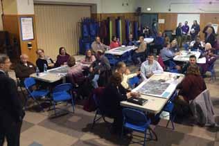
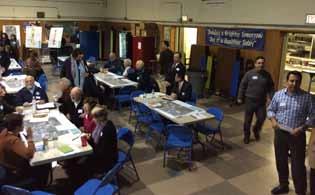
10 Appendix D: Community Open House / Workshop Overview The Town of Ashland hosted a community open house and workshop on the evening of March 25 th regarding public realm improvements to Pond Street. Over 100 people joined in the conversation at the open house and workshop. The goals of the workshop were to: Begin a new community conversation Establish a foundation upon previous studies Identify and discuss key issues Identify and discuss key opportunities Explore a shared corridor vision and priorities The open house and workshop included several individual and small group exercises that invited conversation and feedback. The exercises included a visual preference survey, mapping of issues, mapping of opportunities and shared corridor visioning with potential street cross sections. The summaries that follow reflect the information discussed and gathered during these exercises. The exercises were facilitated by members of the Town s Project Working Group (PWG), and the Town s consultant team of The Cecil Group and Green International. Summary Report Parallel to the community workshop, the summary is presented in the following sections: Issues Opportunities Shared Vision Visual Preference Survey Open House Discussion Notes In addition, the visual preference survey was hosted online (at the ARA and Town of Ashland websites); the summary of the online survey results follows the open house discussion notes. The online survey received 84 responses from the community. The cecil group Appendix D xliv
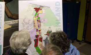
11 Existing corridor Land uses W A S H I N G T O N A V E town of framingham G R E E N H A L G E R D B U T T E R F I E L D D R I V E A L G O N Q U I N T R A I L S E W E L L S T R E E T N I C K E R S O N R O A D E L I O T S T R E E T S P Y G L A S S H I L L D R I V E town of HolliSton Land Use Legend: Single Family Two Family Multi-Family Mixed Use / Commercial Retail Utilities Vacant xlv Appendix D Pond Street Revitalization

12 Existing corridor Zoning Zone Minimum Lot Minimum Lot Minimum Front Minimum Side Minimum Rear Maximum Height Area (SF) Frontage (FT) Yard (FT) Yard (FT) Yard (FT) (Stories/FT) I 30, /35 CV 15, /35 CH 30, /35 RM 30, NA/35 RA 30, NA/35 RB 20, NA/35 PSMUOD 30, /NA town of framingham G R E E N H A L G E R D B U T T E R F I E L D D R I V E A L G O N Q U I N T R A I L S E W E L L S T R E E T N I C K E R S O N R O A D E L I O T S T R E E T S P Y G L A S S H I L L D R I V E town of holliston Pond St Mixed Use Overlay District PSMUOD Zoning Legend: Industrial I Zone Village Commerce CV Zone Highway Commerce CH Zone Residential Multifamily RM Zone Residential A RA Zone Residential B RB Zone Parcels Abutting Pond St The cecil group Appendix D xlvi


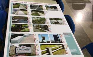
13 Open House 5-6PM Workshop 7:15-8:30PM visual preference survey PleaSe vote for your Preference for each image A1:a A1:c A1:e A1: Street Design A1:b Not A1:d Not Not Not Not A2:a A2:c A2:e A2: Intersection Treatments A2:b Not A2:d Not Not A3:a Not A3:c Not visual Preference Survey STReeT / INTeRSeCTION A3: Site Access / Curb Cuts A3:b Not A3:d Not Not Not Pond Street revitalization Project COMMUNITY WORKSHOP Tuesday March 25 th, 2014 Warren Elementary School 73 Fruit Street Ashland xlvii Appendix D Pond Street Revitalization


14 Open House 5-6PM Workshop 7:15-8:30PM PleaSe vote for your Preference for each image B1:a B1:c B1:e B1: Sidewalk Design B1:b Not B1:d Not Not Not Not B2:a B2:c B2:e B2: Landscaping B2:b Not B2:d Not Not B3:a Not B3:c Not visual Preference Survey PUblIC FRONTage B3: Sreet Furnishings B3:b Not B3:d Not Not Not Pond Street revitalization Project COMMUNITY WORKSHOP Tuesday March 25 th, 2014 Warren Elementary School 73 Fruit Street Ashland The cecil group Appendix D xlviii


15 PleaSe vote for your Preference for each image C1:a C1:c C1:e C1: Building Facades / Frontage C1:b Not C1:d Not C1:f Not Not Not Not C2:a C2:c C2:e C2: Landscape C2:b Not C2:d Not C2:f Not Not Not Not C3:a C3:c C3:e C3: Parking C3:b Not Not C3:d Not Not visual Preference Survey PRIvaTe FRONTage Pond Street revitalization Project COMMUNITY WORKSHOP Tuesday March 25 th, 2014 Not Open House 5-6PM Workshop 7:15-8:30PM Warren Elementary School 73 Fruit Street Ashland xlix Appendix D Pond Street Revitalization
16 Area Section Image Average Score Total Votes A B A1 C D E A A B A2 C D E A A3 B C D Votes / Image Area Section Image Average Score Total Votes A B B1 C D E A B B B2 C D E A B3 B C D Votes / Image Area Section Image Average Score Total Votes A B C1 C D E F A B C C C2 D E F A B C3 C D E Votes / Image Most Liked Second Liked Least Liked The cecil group Appendix D l


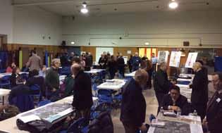
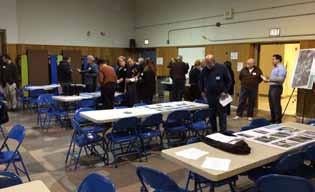
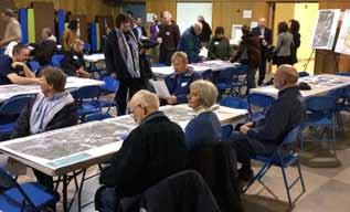
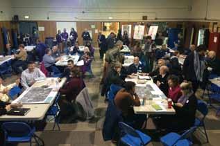
17 Community workshop photos li Appendix D Pond Street Revitalization


18 The cecil group Appendix D lii
19 March Community workshop Summary: Issues Ashland Pond Street Revitalization Project Community Workshop / Open House Responses: Issues Warren Elementary School 73 Fruit Street Tuesday, March 25 th, 2014 Open House 5 Workshop 7:15 9 PM Overall Function is the priority Form is Secondary Create strategic moves There are existing 500 homes within the corridor which means residents and walkers No identity Area looks depressed and depressing Noise resonates from corridor and plazas to secondary residential Lack of streetscape Less cars / more humans / walkability (2) Maintenance / Appearance Trash issues (4) Along street near Market Basket plaza Behind industrial park on Pond Street Aesthetically unappealing (4) Utilities lines and poles (3) Disjointed / no continuity Roadway and private property CNG relay station Market Basket Plaza is unappealing Piling snow at edge of intersection is dangerous Pollution - run off into Lake (Washakum Pond) Private Aesthetics (2) Gas Stations Convenience stores Condition of existing structures - unappealing Zoning and design guideline issues (7) Zoning issue against Hodgepodge Development that the residents can choose How do we attract business that create a unique and attractive area (2) Proposed development is an issue not attractive Lack of follow up on rules and restrictions to enforce proper design of corridor (2) Lack of consistency No uniformity in buildings setbacks too much pavement (2) Vacancies (3) Businesses (4) Parcels Business property owners along corridor don t care much about what s going on along corridor Lack of parking for existing businesses Connectivity / Accessibility / Circulation Vehicular Traffic and circulation at Algonquin Trail (4) Volume and speed truck access (2) Continuity none No gateway Intersection is difficult to maneuver Excessive speeding Cut through traffic is an issue (2) Treacherous left turn onto Pond from Algonquin Trail (2) Access into businesses / residential Double left at sears doesn t work (3) Existing Shaw s exit left is difficult to maneuver and potentially should not be allowed (3) Access in to shipping area at Sears is an issue Lack of turning lanes in / out of business Can t take left Waushakum / Washington too much traffic Left hand turn onto Eliot from Pond is an issue Hard to cross from Spyglass Hill to Shaw s Hard to turn onto Pond Street from northern residential section Nickerson Road intersection is difficult to exit Site distance is an issue at the curve before Spyglass Hill (4) Excessive curb cuts (7) 73 curb cuts is too many Consolidate drives at Market basket Lane configurations Eliot Street intersection layout is problematic No left arrow at Eliot Street southbound Left turns are congested and unsafe liii Appendix D Pond Street Revitalization
20 Traffic light timing and directionality issue Heavy traffic / drivers who don t pay attention Speeding (6) Issue from market basket to Algonquin Trail Speed limits go up at southern town border (2) People drive too fast and impatiently Framingham acts as a bottleneck hard to go and come from that direction Bad passing habits on right hand shoulders using as lane Pedestrian / Cyclist Accessibility issue Getting to road is hard as it gets developed, access will be hard To town connection is an issue with students Pedestrian access at Algonquin Trail Lack of sidewalks (6) Kids walking to Dairy Queen Very steep walk on Pond Street at Eliot Street No Crosswalks only one that crosses Pond Street Bay Circuit / Upper Charles trail Bike pedestrian access at bay circuit trail Hard to access trails / woodlands tough to park Access to trails Trail w/o crossings Can t walk at the residential section (Framingham) Not walkable Streetscape Lack of signage Transit signage No Gateway at Framingham or Holliston (2) Sign bylaws? No identification of Bay Circuit Trail No pedestrian signs Business signs ugly Lack of bike lanes (3) Minimal existing space Safer sidewalks No sidewalks; Framingham there are sidewalks / Ashland there are none. Can t safely walk Enhanced and more crosswalks Lack of curb definition at asphalt at Residential area (2) Lack of lighting Bay circuit trail has no identity No pedestrian connection Not pedestrian friendly Vehicular Oriented Safety for bicycles High bicycle use and safety issues from Framingham Not enough room for cars to pass Safety Traffic calming issues Not safe for biking (3) Cycling safety on 126 (Dangerous) Cycling on Eliot Street Public safety no sidewalks for residential communities (4) Sidewalks / stones in the berm area Hard to walk Threat to personal safety at Market Basket (2) Very thin buffer zone to make sidewalks unsafe Other Notes Speed limit inconsistencies Too many curb cuts in most locations and they need to be consolidated There is a potential conflict with the current posted speed limit on the south side of the corridor. It increases to 45 mph in Ashland as the driver would maneuver around the bend and would immediately have to slow down to maneuver the current or proposed intersection at Spyglass Hill Road The alignment of the center turn lanes between Spyglass Hill and Eliot Roads is problematic and leads to a issue for drivers trying to enter the turn lane Accidents at Hess gas station because of speed 45 MPH from Holliston Mish-Mash no Architectural Standards Trashy look for town-inconsistency Head on collision potential between Eliot and Spyglass The cecil group Appendix D liv
21 march 25th Community workshop Summary: opportunities lv Ashland Pond Street Revitalization Project Community Workshop / Open House Responses: Opportunities Warren Elementary School 73 Fruit Street Tuesday, March 25 th, 2014 Open House 5 Workshop 7:15 9 PM Overall A lot condos = a lot of walkers Improve overall aesthetics Transition from vehicle to pedestrian Connectivity Walkable Bikeable Pond Street is a traditional place and should look better Cohesive Look If you build it they don t necessarily come The people are nice in the neighborhoods Streetscape More attractive thoroughfare Upper scale feel Design Roadway Narrow the driving lanes to 11 feet (put Route 126 on a road diet (2) Reduce maximum speed to 30 mph Problematic Left turns lane to be resolved at Shaw s area Create a turning lane (northbound onto Algonquin Trail (2) Potential for or against roundabout at Spyglass Hill Drive (2) MassDOT s 5-foot gutters are excessive need to balance with other needs More / better parking (on-street) Meet the current but future traffic projects Continuous curbing (5) Periodic breaks for crosswalks and bikes Improve street definition Curbs for residential drives Intersection improvements More traffic lights Elliot exit from Shaw s has the potential for a pole mounted signal Opportunity for design improvement at Algonquin Trail intersection Strategic shared access points into businesses where possible Center left turn lane at Market Basket Plaza Recreational / Public and Open Spaces Trail Parallel to road Continue a possible biking network More public space Create a public park along the roadway Join the break in Bay Circuit Trail with safe, separated pedestrian and bicycle infrastructure Connection to the Upper Charles Rail Trail Connectivity 11-foot multi-use path (MUP) on west side of road with 4-foot landscaped strip to buffer from cars (sustainability, safety, complete streets, build community) Improve sidewalk connections to various businesses and residential along corridor (2) Improve crossing at critical intersections along corridor (4) Pedestrian bridge at the Spyglass hill intersection to the shopping plaza, which can be used for 2-way traffic Bike access and accomodations; cycletrack, bike lanes, bike racks (6) Connection from homes to train station (2) Continuity (bikes / pedestrians) Create a 4-foot sidewalk on east side where width permits Safety Traffic calming measures (2) Traffic safety (2) Cut back slopes to allow for better connection and visibility at Spyglass Hill Drive Breakdown lane for bike lane Flashing lights at critical intersection crosswalks that turn red for pedestrians (4) Safety for non vehicle commuters to and from Ashland. Transit De-Emphasize cars; emphasize people (walking and biking MWRTA more stops (2) Appendix D Pond Street Revitalization
22 o Curb indentation at inbound to Framingham and outbound to Holliston (3) o Bus options Eliot Street Creating a gateway intersection Left turn lane at southbound (3) Crosswalks Landscape Islands Improve right turn Sidewalks Amenities Attractive streetscape Landscaping (9) Nanantum Road islands at cross streets Vegetative buffer Landscape guard rail, sidewalk Bioswale potential (engineered swale) Consistent landscape / greenery Add buffers at parking Existing woodland vegetation is attractive Landscape enhancements More landscape Landscaped center island with curbing and pedestrian breaks (i.e. crosswalks) Street trees (4) Create a tree canopy over the road Utilities put underground (pay for it) Trash control Pedestrian crosswalks (6) Algonquin Trail location Residential northern section Eliot Street Wayfinding signage (9) Enhance trail with boardwalk and signage Aesthetically appealing Signage clock theme (clock town home of electric clock) Better identify crosswalks with signs Gateway signage (2) Entrances to the town Corridor signage Create brand and marketing identity (6) Sidewalks (4) Ornamental Lighting (3) Banners Bike lanes (2) Bike Access at Eliot Street both sides of street Community Engagement Use 126 to get businesses involved Private / public group that rallies surrounding landowners for corridor improvements Resources for residents Education and safety items for bikers that work in the corridor potentially provided by the business Development Zoning Tax incentives Allow for outdoor seating opportunities Building setbacks to be reduced (2) More visibility for all businesses on corridor Examples Route 20 Wayland Small business Sudbury Close to Holliston Center streetscape is appealing Higher quality not Wellesley Zoning changes Zone for the growth we want instead of just more growth (undeveloped commercial is preferable to more fast food or other junk businesses) Eliminate the commercial Highway zone same zoning as downtown Create an Interim Planning Overlay District (IPOD) for 2 years to temporarily slow growth until redesign is approved by MassDOT (2) Change in land use zoning on Nickerson Road (relocate industries in change to higher uses) Parking Businesses need parking but store frontage on street Parking only in rear of buildings no large parking lots visible from street No on-street parking (not enough right-of-way and dangerous for bicycles Architectural Establish a minimum floor area ratio (FAR) of at least 1.0 The cecil group Appendix D lvi
23 Maximum building height 3 stories (reduces from 5 unless 300-foot setback) Making design review mandatory for any project along the corridor (3) Not more drive through businesses Reduce commercial signage (maximum 3x3 with no grandfathering) Algonquin Trail Frontage don t development Opportunities Live work play Entertainment Street design Cut through at Eliot and Algonquin to alleviate congestion at Algonquin Walkability is key for restaurant viability Existing / Potential Businesses Alehouse! Encourage new businesses which are unique, attractive, local and non chain (10) Better Restaurants Different types of businesses Dog daycare Bakery Gift shop Family Oriented Business More breakfast / walking / biking (combination) options New business for trail use No more fast food Add quality shopping (Wellesley gallery) Hotel possibility Village concept for Algonquin Trail Create a second downtown instead of a highway Commercial development Small office buildings to improve tax base; Grade A office space / make it appealing Medical geriatric services to accommodate assisted living facility Mixed use; shops so your don t to go to mall Recreational destination Connectivity Kids walking to Dairy Queen Work with what we have The land near Holliston border should be used wisely in development Some appealing existing structures Inventory of properties showing what can go where Capitalize on surrounding communities Market basket destination Old Blockbuster Making into something Recreational Opportunities Open Spaces Accessible recreation Need park or gathering areas / green space in corridor More playgrounds on corridor Access to open space (2) Playgrounds / Parks on 126 Multi-use path Connect Bay circuit trail Make trails accessible Enhance Trail System Revitalize trails / make them successful / more trails Leverage wetlands with nature boardwalk Acknowledgement for the Bay Circuit Trail crossing Wetland boardwalk Rail Trail Connection to Bay Circuit Trail Relocation of bay circuit trail Back street walking paths lvii Appendix D Pond Street Revitalization
24 June 3rd Community workshop Summary The Town of Ashland hosted a community meeting on the evening of June 3 rd to review alternative design concepts for Pond Street improvements. Nearly 200 residents attended and provided the following feedback on the (2) concept alternatives. Corridor Community Feedback Negative Issues: No cycle tracks (3) lack of separated Too many dividers Consistency is boring (unique to community) Length of medians Speed existing No crosswalk at Dairy Queen Pedestrian Lighting Need Bus Stops: Algonquin New Dunkin Assisted Living near Holliston Long medians don t allow turns Snow in median Narrow roads can 2 large vehicles pass? Off hours speeding? Destinations accessible to families via bike Bike access to Framingham MBTA Station Platooning from signals good for side streets Roundabouts harder to use than rotaries Dooring with bike lanes Maintenance of landscape and medians Negotiate takings Spyglass Hill why light? Would like more physical separation for bikes from cars Don t waste a lot of beautification space (i.e. Market Basket) Don t combine and if multi-use path exists don t make choppy Need to separate bike lanes from travel lanes biggest downside of Utility issues with sidewalk location Buildings close to street Remove sidewalk from other side of Market Basket and combine Can trucks maneuver? Landscape maintenance Utilities underground? Separate bike lanes from travel lanes In center of corridor road to close to houses compare to existing ROW Traffic concerns at Sears/Spyglass Hill Drive enter/exit Turning lane for McDonald s? Roadway moves closer to condos at Algonquin removes open space Positive Issues: Bike lanes Sidewalk provided for residential near Framingham Sidewalks (2) Consistency from Framingham to Holliston landscaping Turn lanes/signals at Market Basket reduce mess Lighting Consistent bike lanes Light at Spyglass Hill Light at Algonquin and Market Basket Uniform store signage Healthy aspects funding reasons Multi-use path on one side Consistently attractiveness in uniformity Anything is better Pedestrian light at Spyglass Hill Drive no traffic congestion Town Gateway zoning changes Signage The cecil group Appendix D lviii
25 Permeable paving/swales Spyglass Hill light is good Corridor plan looks gorgeous like the consistency Would like to combine bike/walk areas if possible Signal at Algonquin is good Align Algonquin Trail signal sop lines with gas station entry/exit Districts and Nodes Community Feedback Negative Issues: Median concerns for vehicle crossing 2 lane roundabout not safe for bikes On road bike lanes will be used by few Signal at Algonquin could encourage cut through (used as access) Bike lanes not consistent with Framingham and Holliston Bike lanes cars will use it can we separate it, next to cars not safe for children Eliot Street exit from Shaw s/day Care needs to No roundabouts (12) be addressed a roundabout will make it worse Not consistent multi-path Lack of sidewalk No bike lane possibility Positive Issues: Negotiations between ownership Separated bike paths (minimize ROW taking) No grass Algonquin Speed limit reduction? Alignment of Algonquin No way for multi-lane roundabout to be safe for bicyclists Direct crossing at trail, landscape? Landscaping at roundabouts is insufficient Direct sidewalks/crosswalks Sidewalk on both sides Update ability Grading issues at roundabouts Connection (bike trailer w/ kids) Cost issues with roundabouts Shopping Signals Bay Circuit No connection with Framingham & Holliston for bike lane More dangerous bike 4 Add sharrows to other Towns Separate multi-use path Continuity Continuous Yellow lights at crosswalks Work with businesses for more space Snow issues with roundabout at Eliot Street Roundabouts safer and more efficient Parking for Bay Circuit Trail where is it going? Road has different personalities nodes works No Light at Waushakum Avenue? with it Potential redevelopment at IT Business how to deal with Swale for wetlands and lake exiting and entering traffic where the median is shown at Like roundabout and line of sight south of Spyglass Market Basket? Hill Drive Need vertical posts between bike lanes and drivers Off road bike facility Spyglass Hill to Framingham Need directional markers at multi-use path Full red light or bike activated signal at Bay Rotaries for 18 wheelers, difficult crosswalks Circuit Crossing Crossings at businesses Consistent corridor Circular intersection Signal over rotary lix Appendix D Pond Street Revitalization
 typical street right-of-way widths shown to scale with a package of game pieces that showed travel lanes, turn")
26 Community workshop Summary: shared vision The following conceptual street cross sections were created by the community members present at the workshop. In small groups of about 10 people, community members were given a poster with (3) typical street right-of-way widths shown to scale with a package of game pieces that showed travel lanes, turn lanes, sidewalks, bike lanes, landscape, lighting and other amenities. Each group was asked to design a shared vision for what the future of Pond Street should look like. The following images document the cross sections that the community created. The Cecil Group Appendix D lx
27 lxi Appendix D Pond Street Revitalization
28 The Cecil Group Appendix D lxii
29 lxiii Appendix D Pond Street Revitalization
ALT E R N AT I VE 1 C O R R I DO R - SHEET 2
 xxvii Appendix C Pond Sree Revializaion Bus dolupa rae exceprovid u la apiduci officiandae ommo eium quae dolupain odi re corae si re, simusamus au dis au quian ven in conserae. Ima sediaem quam verem.
5 CIRCULATION AND STREET DESIGN
 5 CIRCULATION AND STREET DESIGN This chapter describes circulation and streetscape improvements proposed for the Northwest Chico Specific Plan Area. It includes detailed design specifications for existing
Vision: Traditional hamlet with an attractive business/pedestrian friendly main street connected to adjacent walkable neighborhoods
 N D. Focus Area II Vision: Traditional hamlet with an attractive business/pedestrian friendly main street connected to adjacent walkable neighborhoods Transit Road Focus Area II is located in the Hamlet
Tonight is for you. Learn everything you can. Share all your ideas.
 Strathcona Neighbourhood Renewal Draft Concept Design Tonight is for you. Learn everything you can. Share all your ideas. What is Neighbourhood Renewal? Creating a design with you for your neighbourhood.
Ocean Park Boulevard Green Street Project Alternatives & Trade Offs
 Planning Commission March 4, 2009 Ocean Park Boulevard Green Street Project Alternatives & Trade Offs Purpose of Tonight s Meeting Review concept plans and options Provide input on alternatives and trade-offs
A CHANGING CITY. of Edmonton, it is essential that it reflects the long-term vision of the City.
 A CHANGING CITY By the year 2040, Edmonton will be home to more than 1 million people. To accommodate growth and support a healthy and compact city, we need a new approach to development/redevelopment
Make Lincoln Highway an economically vibrant corridor that is safe, efficient, and beautiful for local residents and visitors.
 Lincoln Highway Streetscape Plan Stakeholder Workshop #2 Handout Contents Introduction and Project Vision Planning Principles Specific Recommendations including a Proposed Typical Roadway Section Renderings
NEWMARKET UPHAM S CORNER
 SOUTH STATION Planning Initiative NEWMARKET UPHAM S CORNER COLUMBIA ROAD (P) FOUR CORNERS/GENEVA Working Advisory Group (WAG) Meeting #5 TALBOT AVENUE MORTON STREET BLUE HILL AVE/CUMMINS HWY (P) RIVER
MARTIN LUTHER KING JR. WAY
 OCTOBER 2011 40 Vision and Goals The Martin Luther King, Jr. Way Illustrative Master Plan that follows has been developed through a process of community involvement. It expresses a long term vision for
Item to be Addressed Checklist Consideration YES NO N/A Required Description Complete Streets Guidelines
 Passaic County Complete Streets Checklist - Concept Development Project Name Item to be Addressed Checklist Consideration YES NO N/A Required Description Complete Streets Guidelines Existing Plans Have
MAG Town of Cave Creek Bike Study Task 6 Executive Summary and Regional Significance Report
 Page 1 MAG Town of Cave Creek Bike Study Task 6 Executive Summary and Regional Significance Report August 1, 2012 MAG Project #481 Page 2 Task 6 Executive Summary and Regional Significance Report Introduction
City of Davis East Covell Corridor Plan
 Community Open House #2 January 22, 2014 6:00 8:00 p.m. Veterans Memorial Center, Club Room City of Davis Introduction The (ECCP) is a taking a comprehensive look at the existing transportation systems
Ocean Park Boulevard Streetscape Improvement Project Alternatives & Trade Offs
 City Council Study Session January 27, 2009 Ocean Park Boulevard Streetscape Improvement Project Alternatives & Trade Offs Scope of Work Purpose of Tonight s Meeting Review work to date and direct staff
Agenda. Overview PRINCE GEORGE S PLAZA METRO AREA PEDESTRIAN PLAN
 PRINCE GEORGE S PLAZA METRO AREA PEDESTRIAN PLAN May 28, 2008 Agenda Welcome and introductions Project overview and issue identification Planning context and strengths Design challenges and initial recommendations
Safe Routes to School Action Plan Aberdeen, Idaho
 Background Aberdeen, Idaho is a largely agricultural community of nearly 2,000 people and is located in the southeast portion of the state on the western edge of American Falls Reservoir. The community
ROUTE 81 CORRIDOR STUDY DESIGN CONCEPTS
 RT 81 Corridor Study CLINTON ROUTE 81 CORRIDOR STUDY DESIGN CONCEPTS View north on High Street, with potential improvements to the streetscape Draft Recommendations November 8 th, 2018 TOWN OF CLINTON
CONNECTIVITY PLAN. Adopted December 5, 2017 City of Virginia Beach
 CONNECTIVITY PLAN Adopted December 5, 2017 City of Virginia Beach CONTENTS 1.0 Background & Purpose... 2 2.0 Existing Inventory & Analysis... 3 ViBe District Existing Walking Conditions... 4 3.0 ViBe District
7/23/2017 VIA . Michael Hanebutt City of Sacramento Community Development Department 300 Richards Boulevard, 3 rd Floor Sacramento, CA 95811
 7/23/2017 VIA EMAIL Michael Hanebutt City of Sacramento Community Development Department 300 Richards Boulevard, 3 rd Floor Sacramento, CA 95811 RE: 65 th Street Apartments (DR17-220) Dear Mr. Hanebutt:
2014/2015 BIKE ROUTE PLAN 83 AVENUE PROTECTED BIKE LANE
 About the Project 2014/2015 BIKE ROUTE PLAN The City of Edmonton is planning a major bike route on the south side of Edmonton. This bike route is one part of a plan to provide citizens with transportation
COWETA HIGH SCHOOL AND EAST HIGHWAY 51
 COWETA HIGH SCHOOL AND EAST HIGHWAY 51 Lack of sidewalks along Ben Lumpkin Rd. Lack of crosswalks and ramps at intersection. Hwy 51 is wide to cross as a pedestrian. No ADA compliance or connection to
Chapter 2: Standards for Access, Non-Motorized, and Transit
 Standards for Access, Non-Motorized, and Transit Chapter 2: Standards for Access, Non-Motorized, and Transit The Washtenaw County Access Management Plan was developed based on the analysis of existing
PUBLIC REALM MASTER PLAN
 WESTSHORE BUSINESS DISTRICT PUBLIC REALM MASTER PLAN MASTER PLAN COMMITTEE MEETING MARCH 20, 2013 WESTSHORE BUSINESS DISTRCT PUBLIC REALM MASTER PLAN MACRO-SCALE CONCEPT: A PUBLIC REALM FRAMEWORK DEFINED
CONNECTING PEOPLE TO PLACES
 CONNECTING PEOPLE TO PLACES 82 EAST BENCH MASTER PLAN 07 Introduction The East Bench transportation system is a collection of slow moving, treelined residential streets and major arteries that are the
Ocean Park Boulevard Green Street Project Community Workshop
 Ocean Park Boulevard Green Street Project Community Workshop 2.2.10 Project Objectives Community Priority: reclaim OPB for public open space. Build upon LUCE principles; neighborhood enhancement, connectivity,
WHEREAS delivery trucks also pass through the Narrows, into the northern parking lot, to loading docks in the back of the building.
 CEDAR-ISLES-DEAN NEIGHBORHOOD ASSOCIATION ( CIDNA ) RESOLUTION OPPOSING A DRUG STORE DRIVE THRU, AND COMMENDING DORAN COMPANIES FOR PROPOSING MITIGATING AMENITIES INCLUDING NEW LANDSCAPING AND A DEDICATED
FOCUS AREA 1 - Alberta Avenue Pocket Park 3 (121 Ave and 92 St)
") FOCUS AREA 1 - Alberta Avenue Pocket Park 3 (121 Ave and 92 St) New benches Plant evergreen trees Widen existing sidewalk from 1.5m to 1.8m Marked crosswalk 1.8m wide sidewalk Add pedestrian oriented lights
FOCUS AREA 1 - Alberta Avenue Pocket Park 3 (121 Ave and 92 St) New benches Plant evergreen trees Widen existing sidewalk from 1.5m to 1.8m Marked crosswalk 1.8m wide sidewalk Add pedestrian oriented lights
Duwamish Way-finding and CTR Report
 V. North Tukwila When the North Tukwila Manufacturing and Industrial Center was designated in 1992 as part of the region s land use and transportation plan, the plan called for the area to set a light-rail
City of Wilsonville 5 th Street to Kinsman Road Extension Project
 City of Wilsonville 5 th Street to Kinsman Road Walking Tour & Neighborhood Workshop Summary Report Public Outreach Overview On July 18 th, 2017, the City of Wilsonville hosted a neighborhood walking tour
6.4 RECOMMENDED IMPROVEMENTS
 6.4 RECOMMENDED IMPROVEMENTS 6.4.1 Williston Road Recommendations While all alternatives would be an improvement over existing conditions, Alternative 3B is recommended over the others because it provides
Public Workshop #2. September 14, 2016
 Public Workshop #2 September 14, 2016 Agenda Welcome Project Overview Where We Have Been Alternatives for State Street Land Use Street Design Next Steps 2 Project Overview Create a Vibrant State Street
PRINCE GEORGE S PLAZA METRO AREA PEDESTRIAN PLAN
 PRINCE GEORGE S PLAZA METRO AREA PEDESTRIAN PLAN May 28, 2008 Agenda Welcome and introductions Project overview and issue identification Planning context and strengths Design challenges and initial recommendations
Clarkson Walkability Audit: Results and Recommendations Summary
 Clarkson Walkability Audit: Results and Recommendations Summary The following document was prepared by the Region of Peel and includes a summary of comments made by participants during our breakout discussion
Executive Summary Route 30 Corridor Master Plan
 Route Corridor Master Plan Project Overview The Route Corridor Master Plan is a coordinated multimodal transportation and land use plan for the entire stretch of Route through East Whiteland Township,
Paoli Road Improvement Feasibility Study
 Paoli Road Improvement Feasibility Study & Public Participation Project March 24, 2015 Prepared for: Tredyffrin Township Prepared by: McMahon Associates, Inc. with Town Planning Partnership, LLC Glackin
2014/2015 BIKE ROUTE PLAN 83 AVENUE PROTECTED BIKE LANE
 About the Project The City of Edmonton is planning a major bike route on the southside of Edmonton. The Strathcona Bike Route will connect the communities of Strathcona, Garneau and the University area,
Mainstreet Master Plan Land Use
 Mainstreet Master Plan 04 Land Use Top Recommendations Active Uses: Promote active ground-floor uses such as retail, restaurants, galleries and personal services with interactive storefronts for Mainstreet
complete streets design and construction standards public primer City of Edmonton
 complete streets design and construction standards public primer City of Edmonton introduction Complete Streets are streets for everyone: people who walk, wheel, bike, take transit, or drive. They are
Active Transportation Facility Glossary
 Active Transportation Facility Glossary This document defines different active transportation facilities and suggests appropriate corridor types. Click on a facility type to jump to its definition. Bike
S T A T I O N A R E A P L A N
 The Circulation and Access Plan describes vehicle, pedestrian, and transit improvements recommended within the Concept Plan. In order to create and sustain a vibrant business district that provides pedestrian-friendly
Obey Creek PEDESTRIAN CIRCULATION EAST WEST PARTNERS PEDESTRIAN CIRCULATION CREEK SIDE LANE SLIP STREET SCOTT MURRAY MAIN STREETS EAST/WEST
 THE VILLAGE AT PEDESTRIAN CIRCULATION MAIN STREETS NORTH/SOUTH MAIN STREETS EAST/WEST SLIP STREET CREEK SIDE LANE PEDESTRIAN CIRCULATION DESCRIPTION: Circulation through the downtown of is organized by
El Camino Real Specific Plan. TAC/CAC Meeting #2 Aug 1, 2018
 El Camino Real Specific Plan TAC/CAC Meeting #2 Aug 1, 2018 Land Use Alternatives Goals and Tradeoffs Parks & open space Housing Retail & services Civic spaces Parking Community gathering spaces 3 Alternatives
STEERING COMMITTEE MEETING June 17, Streetscape Overview Burlington Comprehensive Master Plan
 STEERING COMMITTEE MEETING June 17, 2015 Streetscape Overview Burlington Comprehensive Master Plan 1 Introduction Slide This slide show was presented to the Burlington Steering Committee on June 17, 2015
RIVERSIDE, Newton MA BH NORMANDY RIVERSIDE LLC. Riverside Station. A green, transit-oriented community
 Riverside Station A green, transit-oriented community October 6, 2011 TONIGHT S AGENDA: 1. Project Update (5 min.) 2. Master Plan Update (10 min.) 3.Traffic Plan Update (10 min.) Questions & Answers MASTER
Merrick and Memorial Neighborhood Study 5/14/2014 Public Meeting
 Merrick and Memorial Neighborhood Study 5/14/2014 Public Meeting Study Area April 9 Public Meeting Comments Summary Pedestrian Safety - A Walking Neighborhood Pedestrian traffic is very difficult A need
Chapter 3: Multi-Modal Circulation and Streetscapes
 CHAPTER 3: MULTI-MODAL CIRCULATION AND STREETSCAPES Chapter 3: Multi-Modal Circulation and Streetscapes Overview Streetscape improvements have already been completed for Depot Street between Main Avenue
Bicycle and Pedestrian Advisory Committee (BPAC) November 21, 2013
 November 21, 2013") Bicycle and Pedestrian Advisory Committee (BPAC) November 21, 2013 OVERALL LAND USE CONCEPT Overall Broadway Valdez District: 95.5 acres (35.1 acres right-of ways + 60.4 acres developable land) Plan Subareas:
Bicycle and Pedestrian Advisory Committee (BPAC) November 21, 2013 OVERALL LAND USE CONCEPT Overall Broadway Valdez District: 95.5 acres (35.1 acres right-of ways + 60.4 acres developable land) Plan Subareas:
Appendix C. TRAFFIC CALMING PROGRAM TOOLBOX
 Appendix C. TRAFFIC CALMING PROGRAM TOOLBOX PHASE I...2 Do Not Enter Sign...3 One-Way Sign...4 Turn Prohibition...5 Pavement Markings...6 Speed Monitoring Trailer...7 Neighborhood Speed Watch...8 Police
Community Workshop #1 Summary October 2017
 Community Workshop #1 Summary October 2017 1 Background Pleasure Point has a unique character and strong community identity. In 2008, the community and the County developed the Pleasure Point Community
STONY PLAIN ROAD STREETSCAPE
 Jasper Place Revitalization Strategy: Vision The people involved in the Jasper Place Revitalization Strategy envision: Goal 1: Feeling safe in our community Create a community where feeling safe is common--where
Bicycle and Pedestrian Facilities Toolbox (Excerpt from Figure 3.1)
") Appendix B Neighborhood Connections Summaries This Appendix is a supplement to the information presented in Chapter 3 Connect People. The Appendix includes a summary or profile for each of the proposed
Appendix B Neighborhood Connections Summaries This Appendix is a supplement to the information presented in Chapter 3 Connect People. The Appendix includes a summary or profile for each of the proposed
5 Circulation & Parking
 5 Circulation & Parking Downtown Parking & Circulation Strategy. Downtown Wayne has a somewhat disconnected system of local public streets to connect downtown with the residential neighborhoods, and primary
CITY OF WEST LAKE HILLS. Forest View Neighborhood Traffic Calming Study
 CITY OF WEST LAKE HILLS 901 South Mopac Expressway Building V, Suite 220 Austin, Texas 78746 Texas P.E. Firm Registration No. F-929 Klotz Associates Final Report Submittal: March 20, 2015 Revised Final
Safe Streets. City of Lake Forest Park. March 21, 2017
 Safe Streets City of Lake Forest Park March 21, 2017 1 01 WELCOME 2 Agenda WELCOME WHAT IS THIS PROJECT? CONTEXT DRAFT CITYWIDE PROJECTS EXERCISE INTRODUCTION 3 02 WHAT IS THIS PROJECT? 4 WHAT IS THIS
Complete Streets. Designing Streets for Everyone. Sarnia
 Complete Streets Designing Streets for Everyone Sarnia Complete Streets ~ Sarnia ~ 2018 Introduction Our City is made up of a network of streets that we use to go for a walk, cycle to work, drive to the
Memo. Ocean Avenue Corridor Design Project Public Workshop #2 Summary
 Ocean Avenue Corridor Design Project Public Workshop #2 Summary The second public workshop for the Ocean Avenue Corridor Design Project was held on Wednesday, May 14, 2014 from, 6 to 8 pm at Lick Wilmerding
NJDOT Complete Streets Checklist
 Background The New Jersey Department of Transportation s Complete Streets Policy promotes a comprehensive, integrated, connected multi-modal network by providing connections to bicycling and walking trip
APPENDIX A: Complete Streets Checklist DRAFT NOVEMBER 2016
 APPENDIX A: Complete Streets Checklist DRAFT NOVEMBER 2016 Complete Streets Checklist MetroPlan Orlando s Complete Streets Checklist is an internal planning tool for staff to further implementation of
CURBSIDE ACTIVITY DESIGN
 5 CURBSIDE ACTIVITY DESIGN This chapter provides design guidance for separated bike lanes adjacent to curbside activities including parking, loading and bus stops. Typical configurations are presented
WELCOME. Purpose of the Open House. Update you on the project. Present a draft recommended plan. Receive your input
 WELCOME Purpose of the Open House The Town of Smiths Falls has initiated the Beckwith Street Redevelopment Plan that includes the preparation of a streetscape functional design for the renewal of Beckwith
FONTAINE AVENUE STUDY Final Report
 FONTAINE AVENUE STUDY Final Report March 28, 2005 FONTAINE AVENUE STUDY City of Charlottesville March 28, 2005 Renaissance Planning Group Kenneth Schwartz, FAIA, AICP Director of Design Leigh Wilkerson,
BETHEL ROAD AND SEDGWICK ROAD CORRIDOR STUDY
 DRAFT PLAN City Council Meeting August 14, 2017 STUDY AREA Sedgwick Corridor State Route 160, principal arterial with Class 3 access management designation, commuter and freight route, connection to SR
Illustrated Principles of Good Planning
 Illustrated Principles of Good Planning The Miami 21 Zoning Code incorporates time-tested planning principles into the zoning regulations of our City. These are principles that make for better neighborhoods,
UNIVERSITY AVENUE CORRIDOR REDESIGN. January 8, 2017 PUBLIC OPEN HOUSE
 January 8, 2017 PUBLIC OPEN HOUSE COLLABORATIVE COMMUNITY-BASED DESIGN IS THE FOUNDATION TO A SUCCESSFUL PROJECT AGENDA FOR TONIGHT 1 INTRODUCTIONS 2 WHY ARE WE HERE PROJECT NEED 3 SCHEDULE & GOALS 4 OPEN
CENTENNIAL NEIGHBOURHOODS SECONDARY PLAN STUDY CITY OF HAMILTON SPECIFIC MAP COMMENTS FROM DECEMBER 1st PUBLIC INFORMATION CENTRE #2
 OPTION #2 - MIXED USE MEDIUM DENSITY OPTION #3 - MIXED USE MEDIUM AND HIGH DENSITY Look at other uses besides industrial along Barton Street over the long term. Residential facing waterfront over long
Report. Typical Sections. City of Middleton, WI
 Report Typical Sections City of Middleton, WI December 2006 Report for City of Middleton, Wisconsin Typical Sections repared by: Traffic Associates LLC and STRAND ASSOCIATES, INC. 910 West Wingra Drive
Presentation Starts at 5:30 PM
 Presentation Starts at 5:30 PM Public Meeting #1 September 22, 2016 Purpose of Study Conceptual Complete Streets Study on South Carson Street 5 th Street to Roland Drive Approximately 2.5 miles Consider
Broad Street Bicycle Boulevard Design Guidelines
 Broad Street Bicycle Boulevard Design Guidelines Building from the strategies introduced in the 2013 Bicycle Transportation Plan and community input received thus far, City Transportation Staff have identified
Figure 4-10: Pedestrian Improvements Types of Potential Station Area Improvements - Place-Making Improvements
 INCORPORATE FEATURE PAVIN IN CROSSWALK AND INTERSECTION FIELDS Identifies high-priority pedestrian areas and create a station identity through colorful and interesting patterns ADD CURB EXTENSIONS Extending
Lee s Summit Road Improvement Study Public Open House June 7, 2007 Summary of Comment Card Responses
 Lee s Summit Road Improvement Study Public Open House June 7, 2007 Summary of Comment Card Responses Introduction At the Lee s Summit Road Improvement Study Public Open House held Thursday, June 7, 2007
INDEX. Geometric Design Guide for Canadian Roads INDEX
 Acceleration lane, see Lanes, Acceleration Access, 8.1 Access Management and Functional Classification 8.2 Access Management by Design Classification 8.3 Access Configuration 8.4 Building Set-Back Guidelines
EXECUTIVE SUMMARY: TRANSIT-ORIENTED DEVELOPMENT IN SMITHS FALLS, ONTARIO; A COMPARISON BETWEEN TWO SITES
 EECUTIVE SUMMARY: TRANSIT-ORIENTED DEVELOPMENT IN SMITHS FALLS, ONTARIO; A COMPARISON BETWEEN TWO SITES Topic and Purpose In 2007, the Mayor of Ottawa s Task Force on Transportation suggested adding a
Saskatchewan Drive Roadway Rehabilitation and Shared-Use Path Widening
 Saskatchewan Drive Roadway Rehabilitation and Shared-Use Path Widening We are here today to present the draft plan for the Saskatchewan Drive Roadway Rehabilitation and Shared-Use Path Widening project
Bikeway action plan. Bicycle Friendly Community Workshop March 5, 2007 Rochester, MN
 Bikeway action plan Summary The was held on March 5, 2007 at the Rochester Mayo Civic Center. The workshop was hosted by Rochester-Olmsted County Planning Department in collaboration with the League of
Appendix C 3. Bicycle / Pedestrian Planning
 Appendix C 3. Bicycle / Pedestrian Planning BICYCLE/PEDESTRIAN PLANNING 2005 Master Plan GOAL: Provide for safe and convenient bicycle and pedestrian circulation throughout the City. Develop a city-wide
Tuesday, September 25 th Mount Holly Municipal Complex 400 East Central Avenue 5:30pm to 7:30pm. Activity Stations o Where do you Live?
 Meeting Information Overview The public workshop for the Mount Holly Comprehensive Bicycle Plan occurred on September 25, 2018. The drop-in workshop allowed attendees to participate in a series of interactive
MASONIC AVENUE STREET DESIGN STUDY Community Workshop 2. Masonic Ave Street Design Study Community Workshop 2 August 10, 2010
 Masonic Ave Street Design Study Community Workshop 2 August 10, 2010 Introduction MASONIC AVENUE STREET DESIGN STUDY Community Workshop 2 SF Municipal Transportation Agency Javad Mirabdal, Project Manager
TRANSPORTATION NEEDS ASSESSMENT
 TRANSPORTATION NEEDS ASSESSMENT A travel demand analysis was carried out to determine the operational issues and the potential benefit that adding traffic capacity would have on the road network. All the
Community Meeting February 27, 2007 Dorchester Avenue Transportation & Streetscape Improvements Action Plan February 27, 2007
 Community Meeting Tonight s Agenda 6:00 Introductions South Boston/Dot Ave Improvement Study Background 6:15 Consultant Introductions Review of Scope and Schedule Review of Proposed Corridor Wide Guidelines
Observations and Ideas: Toomer s Corner Streetscape Improvements
 Observations and Ideas: Toomer s Corner Streetscape Improvements AUBURN DOWNTOWN MASTER PLAN planning downtown s future August 26, 2013 Observations: Vertical Clutter at Corners 6 3 7 5 9 2 8 4 1 Excess
Draft North Industrial Area-Wide Traffic Plan
 Summary of North Industrial and Hudson Bay Industrial Recommended Improvements Table 1. Summary of s Item Location 1 2 3 4 5 6 7 8 9 10 11 12 Millar Ave north of 51st St Super 8 Motel back lane 400 Block
Military Road Safety Improvements
 Military Road Safety Improvements 26 th Road North to 31 st Street North SUMMARY OF DATA REVIEW AND PRELIMINARY RECOMMENDATIONS Prepared for: Department of Environmental Services Traffic Engineering and
Watertown Complete Streets Prioritization Plan. Public Meeting #1 December 14, 2017
 Watertown Complete Streets Prioritization Plan Public Meeting #1 December 14, 2017 Goals for Public Meeting Overview of MassDOT Complete Streets Funding Program Educate the community on Complete Streets
East Burke Transportation, Safety and Capacity Improvements
 East Burke Transportation, Safety and Capacity Improvements The purpose of this project is to increase mobility and improve safety for pedestrians, cyclists, and motor vehicles along VT Route 114 in the
Southview Blvd & 3 rd Avenue Improvement Project. Public Open House December 4, to 7pm
 Southview Blvd & 3 rd Avenue Improvement Project Public Open House December 4, 2014 5 to 7pm Southview Blvd & 3 rd Avenue Public Information Meeting Agenda Presentation 5:30 to 6:15 pm Purpose of Project
Public Information Centre
 WELCOME Public Information Centre Father Tobin Road Lougheed Middle School - Library Wednesday November 7, 2012 7:00 p.m.to 9:00 p.m. Please sign in Neighbourhood Traffic Calming Guide Background The City
Transportation Corridor Studies: Summary of Recommendations
 Transportation Corridor Studies: Summary of Recommendations Route 4 Corridor Study: Route 10 Corridor Study: Route 44 Corridor Study: Route 175 Corridor Study: Route 5/15 Corridor Study: Rentschler Field
Bicycle Facilities Planning
 Bicycle Facilities Planning Overview Types of Cyclists Purpose for Riding Types of Facilities Bike Lanes Bicycle Boulevards Cycle Tracks Intersections Signals Signing and Marking Discussion Types of Bicyclists
City of Sammamish. Welcome. Issaquah-Fall City Road Improvements Project Phase I Design: 242nd Avenue SE to Klahanie Drive SE
 Welcome Welcome to the third community meeting for the Issaquah-Fall City Road Improvements Project. AGENDA 6:00 p.m. Welcome and sign-in 6:10 p.m. Presentation 6:50 p.m. Open house Learn about the roadway
Introduction. North 12 th Complete Street Project Overview
 Introduction On Wednesday, March 1, 2017, the City of Sacramento, in partnership with Sacramento Regional Transit District and the Sacramento Housing and Redevelopment Agency, hosted a community outreach
Giles Run Connector Road
 Giles Run Connector Road Laurel Hill Adaptive Reuse Area to Laurel Crest Drive South County Federation Meeting June 14, 2016 History Connector road included in the Laurel Hill Comprehensive Plan amendment
EXECUTIVE SUMMARY. Vision
 Vision Walking and bicycling in Salt Lake City will be safe, convenient, comfortable, and viable transportation options that connect people to places, foster recreational and economic development opportunities,
MAKE YOUR PLACE IN CHANNELSIDE
 MAKE YOUR PLACE IN CHANNELSIDE INTRODUCTION PROJECT LIMITS Channelside Drive from Cumberland Ave to Kennedy Boulevard EXISTING CONDITIONS EXISTING CONDITIONS CHANNELSIDE DRIVE FROM E. CUMBERLAND AVENUE
TRANSPORTATION STANDARDS
 INTRODUCTION LOCAL STREETS ON-STREET PARKING SIDEWALKS STREET LIGHTING STREET FURNISHINGS TRAFFIC CALMING STREET TREES MEDIAN PLANTING BOULEVARD LOCATIONS VILLAGE CENTER STREET LOCATIONS RESIDENTIAL STREET
14 TH STREET TRANSPORTATION & STREETSCAPE DESIGN STUDY PLAN B PLAN B TRANSPORTATION & STREETSCAPE RECOMMENDATIONS
 14 TH STREET TRANSPORTATION & STREETSCAPE DESIGN STUDY PLAN B PLAN B TRANSPORTATION & STREETSCAPE RECOMMENDATIONS 141 Symbols Recommendations - Southern End of 14th Street Study Area Streetscape Each icon
Transportation Planning Division
 Transportation Planning Division Presentation Outline Study Tasks Recap of Previous Meetings Data Collected Focus Areas within Study Limits Design Principles Tool Box Recommended Concepts Schedule Moving
Roads and Vehicular Traffic Design Principles. Roads and Vehicular Traffic Recommendations
 CIRCULATION AND PARKING roads and vehicular traffic The Campus Master Plan updates the campus transportation network through a multi-modal approach that encourages walking and biking while improving vehicular
WELCOME Public Information Centre
 WELCOME Public Information Centre Fernforest Drive Brampton Soccer Centre Community Room #2 Tuesday January 19, 2016 6:30 p.m.to 9:00 p.m. Please sign in Neighbourhood Traffic Calming Guide Background
GLEN EIRA CITY COUNCIL. MURRUMBEENA Transforming our neighbourhood together our concepts based on your ideas
 GLEN EIRA CITY COUNCIL MURRUMBEENA Transforming our neighbourhood together our concepts based on your ideas 1 WHAT HAVE WE HEARD? WHAT NOW? Stage one Tell us what you love about your shopping strip November
Town of Mooresville, North Carolina Neighborhood Traffic Calming and Control Device Policy
 Town of Mooresville, North Carolina Neighborhood Traffic Calming and Control Device Policy Adopted January 6, 2014 Town of Mooresville Development Services Department TOWN OF MOORESVILLE NEIGHBORHOOD TRAFFIC
What are the Qualities that make Newark a Bicycle Friendly Community? What are aspects that make Newark less Bicycle Friendly?
 What are the Qualities that make Newark a Bicycle Friendly Community? Many stores are within biking distance (1) Lots of bike lanes and new trail Existing bike routes (2) Designated bike lanes on Del ave.