Session 1 23 CFR 772: Type I Project Definitions
|
|
|
- Ira Eaton
- 6 years ago
- Views:
Transcription


1 Session 1 23 CFR 772: Type I Project Definitions Facilitator: Carole Newvine, Oregon DOT Participants: Carole Newvine, Oregon DOT Mariano Berrios, Florida DOT Tom Hanf, Michigan DOT Greg Smith, North Carolina DOT

2 What are Type I Projects? per FHWA Traffic Noise FAQs, May The construction of a highway on a new location 1

3 Type I Projects continued 2. The physical alteration of an existing highway where there is either: a. Substantial Horizontal Alteration. A project that halves the distance between the traffic noise source and the closest receptor, from the existing condition to the future build condition, or; 2


4 Type I Projects continued b. Substantial Vertical Alteration. A project that removes shielding, exposing the line-of-sight between receptor and traffic noise source - by either altering the vertical alignment of the highway or by altering the topography between the highway traffic noise source and the receptor Increasing the Height of an Overcrossing Multi-Use Path: Constructing a Gap in the Berm I-205 & LRT 3


5 Type I Projects continued 3. The addition of a through-traffic lane(s). This includes the addition of a through-traffic lane that functions as a HOV lane, High-Occupancy Toll (HOT) lane, bus lane, or truck climbing lane; or, 4. The addition of an auxiliary lane, except for when the auxiliary lane is a turn lane; or, 5. The addition or relocation of interchange lanes or ramps added to a quadrant to complete an existing partial interchange; or, Proposed On Ramp Proposed Off Ramp 4


6 Type I Projects continued 6. Restriping existing pavement for the purpose of adding a through-traffic lane or an auxiliary lane 7. The addition of a new or substantial alteration of a weigh station, rest stop, ride-share lot or toll plaza. Portland Ride-Share If a project is determined to be a Type I project under this definition then the entire project area as defined in the environmental document is a Type I. 5

7 Florida Department of TRANSPORTATION Type I Projects Definitions CEE Noise Practitioners Summit 2015 October 21-22, 2015 Baltimore, MD Mariano Berrios Environmental Programs Coordinator Florida Department of Transportation
8 Today s Presentation What s in 23 CFR 772? What s in the FHWA guidance? Florida s additional definitions for auxiliary lanes and interchange ramps work Florida Department of Transportation
9 What s in 23 CFR 772? Type I project (1) Construction of highways on new location (2) Physical alteration of existing highway horizontal or vertical (3) The addition of a through-traffic lane(s). This includes the addition of a through-traffic lane that functions as a HOV lane, High- Occupancy Toll (HOT) lane, bus lane, or truck climbing lane; or, (4) The addition of an auxiliary lane, except for when the auxiliary lane is a turn lane; or, (5) The addition or relocation of interchange lanes or ramps added to a quadrant to complete an existing partial interchange; or, Florida Department of Transportation
10 What s in 23 CFR 772? Type I project (6) Restriping existing pavement to add additional through traffic lanes or auxiliary lanes (7) Addition of a new or substantial alteration of weigh stations, rest stops, ride share lots, or toll plazas Florida Department of Transportation
11 What s in the FHWA guidance? FHWA Guidance for Type I Projects Involving Auxiliary Lanes: The addition of an auxiliary lane is a Type I project, unless the auxiliary lane is a turn lane. Highway agencies should take a broad approach to defining turn lanes when considering projects with auxiliary lanes. Consideration of auxiliary lanes on local roads should be limited to those that could be used as a through lane (including bus or truck climbing lanes) rather than lanes used for parking, speed change, turning or storage for turning or weaving. For interstates, limit consideration to auxiliary lanes between two closely spaced interchanges to accommodate weaving traffic and auxiliary lanes carried through one or more interchanges. Florida Department of Transportation
12 Auxiliary Lanes Auxiliary Lanes: Florida s Plans Preparation Manual defines auxiliary lanes as: The designated widths of roadway pavement marked to separate speed change, turning, passing and climbing maneuvers from through traffic. They may also provide short capacity segments. Wikipedia A turn lane is set aside for slowing down and making a turn, so as not to disrupt traffic. By removing turning traffic from the through lanes, motorist safety is improved and delay is removed. Florida Department of Transportation
13 Auxiliary Lanes Sooo. based on 23 CFR 772, addition of an auxiliary lane is Type I project. Based on the FDOT definition of auxiliary lane, the following could be Type I projects: Acceleration lanes Deceleration lanes Turning lanes Two way left turn lanes Weaving lanes Passing lanes Truck climbing lanes (not many in Fl.) Operational lanes (extra lane between interchanges) Florida Department of Transportation
14 Auxiliary Lanes FHWA guidance: Local roads limit consideration to auxiliary lanes that could be used as through lanes (including bus or truck lanes). Argument: Define auxiliary lanes that could be used as through lanes. Interstates (freeways and expressways?) limit consideration to: - auxiliary lanes between two closely spaced interchanges (to accommodate weaving) and - - auxiliary lanes carried through one or more interchanges (operational lanes) Argument: - What is a closely spaced interchange? (See table in next slide) - Other auxiliary lanes (other than lanes carried though one or more interchanges) between not closely spaced interchanges. (Ex. Long acceleration lanes) Florida Department of Transportation
15 Interchange Ramps Interchange lanes and ramps Not much guidance on what constitutes addition or relocation of interchange lanes ramps added to a quadrant to complete an existing partial interchange other than the language in the rule. Adding a lane Are all lane additions considered adding capacity, therefore a Type I? What constitutes a lane relocation? Distance relocated? New distance between outside of lane and receptor (reduce by ½)? Realignment of existing ramps not addressed, how much realignment? Considered a lane relocation? Extension (lengthening) of existing acceleration lanes (max. length of acceleration lane?) Florida Department of Transportation
16 Florida Specific Additions to Type I List Based on discussions with the FHWA Florida Division and new online guidance from FHWA. FDOT developed a Type I Projects Matrix to assist the FDOT Districts in better identifying what projects are considered Type I projects including clarification of unique situations that are not clear in the rule or guidance. Florida Department of Transportation
17 Matrix Type 1 Not Type 1 (No Noise Study Required) 1 Construction of highway on new location 2 New or relocated interchanges 3 Addition of new interchange ramps (add a ramp where no ramps existed). Viewed as a new location. 4 Relocation of an interchange ramp where the edge of the outside lane on any segment of the ramp reduces the distance to the closest receptor by one-half. (See #6 for realignment of ramps) Florida Department of Transportation
18 Matrix 5 Increasing capacity to an existing on or off interchange ramp (by adding lanes) including associated merge lanes. Viewed as a new location. 6 Lengthening an existing interchange ramp s acceleration or deceleration lane and associated merging into the mainline to a total of more than 2500 feet (from the gore to the end of the lane), or re-aligning where any segment of the ramp reduces the distance to the closest receptor by one-half. 7 Alteration of the horizontal alignment of an existing highway such that the edge of the outside lane reduces the distance to the closest receptor by one-half. Lengthening an existing interchange ramp s acceleration or deceleration lane and associated merging into the mainline (total length less than 2500 feet), or realigning where any segment of the ramp reduces the distance to the closest receptor by one-half. Alteration of the horizontal alignment of an existing highway such that the edge of the outside lanes DOES NOT REDUCE the distance to the closest receptor by onehalf. Florida Department of Transportation
19 Matrix 8 Alteration of the vertical alignment, or the surrounding topography, where existing shielding is removed and the line of sight between the noise source and the receptor is now direct. (Activity does not include removal of vegetation). 9 Addition of new through-lanes that increase capacity to an existing highway. (Noise analysis required on both sides of the highway whether the lanes are all in one direction or both directions of travel.) 10 Restriping existing pavement to add a through-lane or auxiliary lane (See #13, #14 and #15 for auxiliary lanes). Florida Department of Transportation
20 Matrix 11 Addition of new or substantially altered weight station, rest stop, ride share lot or toll plaza. 12 Addition of ramps or new lanes serving as climbing lanes for buses and trucks. 13 Addition of auxiliary lanes used as a through lanes on local roads. Florida Department of Transportation
21 Matrix 14 Auxiliary lanes on freeways and expressways connecting two or more interchanges (continuous lanes longer than 2500 feet from gore to gore). Auxiliary lanes on freeways and expressways connecting two closely spaced interchanges (less than 2500 feet from gore to gore) to accommodate weaving traffic. 15 Turn lanes at intersections associated with arterial highways 16 Bicycle and Pedestrian paths 17 Safety activities (23 USC 402) 18 Landscaping Florida Department of Transportation
22 Matrix 19 Installation of fencing, signs, pavement markings, small passenger shelters, traffic signals, railroad warning signals (that don t disrupt traffic patterns) 20 Deployment of electronics, photonics, communications, information processing to improve safety and security 21 Re-surfacing, restoration, rehabilitation or reconstruction of an existing facility (unless there is a change in horizontal or vertical alignment per 7 & 8 above). 22 Electronic toll collection facilities that do not disrupt traffic patterns. Florida Department of Transportation

23 Input? Discussion? Questions? Florida Department of Transportation
24 Michigan DOT Experience CEE Noise Practitioners Summit Baltimore, Maryland October 21-22, 2015 Tom Hanf Michigan DOT
25
26
27

28
29
30
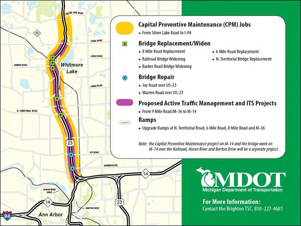
31
32 Park and Ride Lots Substantial Vertical Alteration
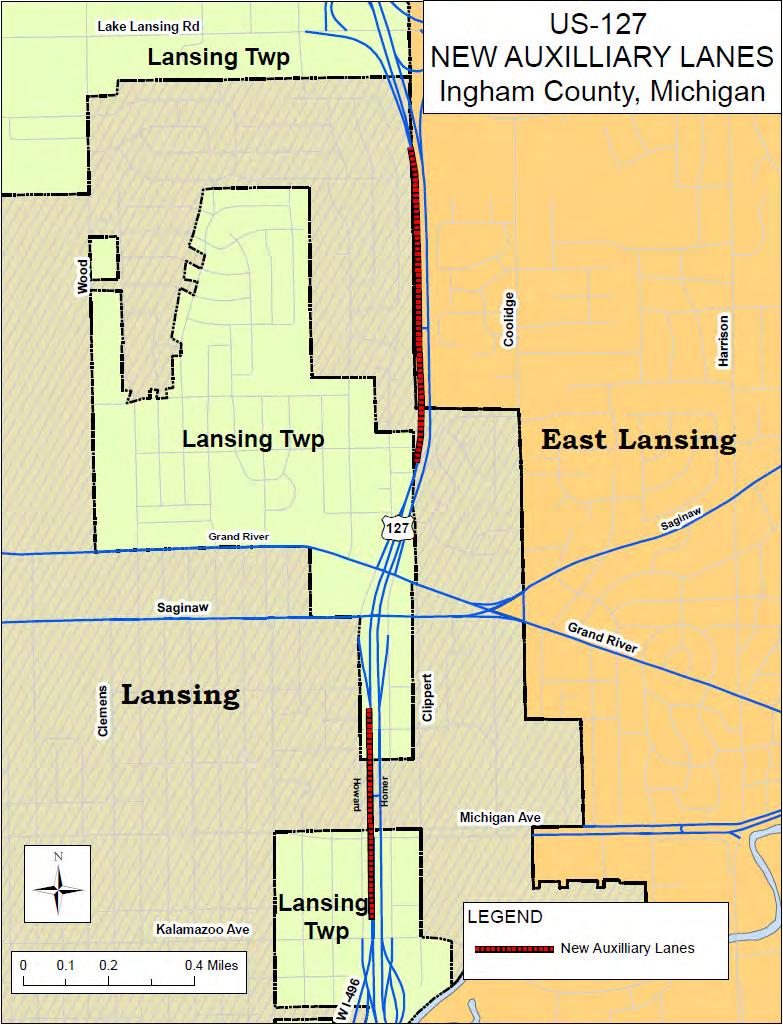
33


34 Type I Project Definitions Considerations 2 NC Projects for Consideration CEE Noise Summit Session 1 Baltimore, MD October 21, 2015
35 Morrisville-Carpenter Road Safety Improvements Power Substation Mixed Residential Commercial 228 Total Receptors 69 Existing Impacts 69 No-Build Impacts 91 Build Impacts 2.0 db(a) Average NL Increase 3 db(a) Maximum NL Increase

36 Morrisville-Carpenter Road Safety Improvements Proposed Additional Lane
37 Morrisville-Carpenter Road Safety Improvements Right Turn Only Auxiliary Lane
38 Morrisville-Carpenter Road Safety Improvements 6 Feasible & Reasonable Noise Walls
39 Morrisville-Carpenter Road Safety Improvements Estimated Project Construction = $ 1,015,000 Estimated Total Wall Cost = $ 560,000 - $ 830,000 or % of Construction Cost Project Abandoned


40 I-40 Between Interchanges Approximately 4500 ft. Lane Between Interchange Ramps To Provide Safer Weave Pattern Ends in Exit Ramp (Right Turn)
41 I-40 Between Interchanges Per FHWA Online FAQ, an auxiliary lane should classify the project as Type I if the auxiliary lane is 2,500 feet or longer. Per 23 CFR 772, A Type I project is required with the addition of an auxiliary lane, except for when the auxiliary lane is a turn lane. Per FHWA Analysis & Abatement Guidance, for interstates, limit consideration to auxiliary lanes between two closely spaced interchanges to accommodate weaving traffic and auxiliary lanes carried through one or more interchanges. Type I Project?
42 Session 1 - Questions Jordahl-Larson, MN: How to determine the substantial vertical alteration without having to conduct a full noise impact analysis? Guidance on existing barriers on Type I projects Tedford, CT: How are Type III Projects defined? Runkle, IL: We get pushback from our districts wanting a threshold length on the addition of a through-traffic lane before it is considered Type I. Is IL unique in this?
43 Session 1 - Questions Burgin, KY: Will any other project types be added to the definition of Type I? (such as where traffic volumes and speeds are especially light/slow) Hanf, MI: Where do manage use lanes that are only scheduled open during peak periods fit in the definition? Auxiliary lanes, through-traffic lanes? Burcham, MO: Under the topic Issues when an entire project is considered Type I if only part of it is Type I. increased project costs?
44 Session 1 - Questions Moch, ND: NDDOT has included provision to in Noise Policy Manual to exclude turn lanes or passing lanes that are equal to or less than 2 miles long. Evans, NH: Should rumble strip installation projects be added to Type I project definition. Of particular concern is the installation of centerline rumble strips within passing zones adjacent to residential neighborhoods. If included as Type I, what procedures/methods are there for predicting noise levels and determining impacts. Dougherty, WV: Should raising the speed limit on an existing FA highway be considered a Type 1 project?
45 Session 1 - Questions Alcala, OH : Issues with the NEPA study area being the noise study area Shellenberger, PA: How to handle Type I projects that will only be in place for a limited time until they are reconstructed and will require another analysis. For example, we are restriping to add a lane and mitigation is feasible and reasonable. In a year we are doing a widening to the same roadway. Can we defer the noise analysis or abatement until the second project is completed? Polcak, MD: Avoidance of impacts via alignment shift, parapet, etc. vs. analysis and implementation of abatement.
Joshua Jester, E.I., Florida Department of Transportation, District One
 MEMORANDUM To: From: Joshua Jester, E.I., Florida Department of Transportation, District One Michael Garau, P.E., Kimley-Horn and Associates, Inc. Date: October 5, 2018 Subject: at Gulfstream Avenue Intersection
Figure 3B-1. Examples of Two-Lane, Two-Way Marking Applications
 Figure 3B-1. Examples of Two-Lane, Two-Way Marking Applications A - Typical two-lane, two-way marking with passing permitted in both directions B - Typical two-lane, two-way marking with no-passing zones
Section 3A.04 Colors. Section 3B.10 Approach Markings for Obstructions
 Section 3A.04 Colors Markings shall be yellow, white, red, or blue, or purple. The colors for markings shall conform to the standard highway colors. Black in conjunction with one of the above colors shall
RE: 2007 NPA Text (Clean Version)
") 1 2 3 4 5 6 7 8 9 10 11 12 13 14 15 16 17 18 19 21 20 22 23 24 25 26 27 28 29 30 31 32 33 34 35 36 RE: 2007 NPA Text (Clean Version) P. 230, Lines 29-30 SECTION 3B.04 White Lane Line Pavement Markings
1 2 3 4 5 6 7 8 9 10 11 12 13 14 15 16 17 18 19 21 20 22 23 24 25 26 27 28 29 30 31 32 33 34 35 36 RE: 2007 NPA Text (Clean Version) P. 230, Lines 29-30 SECTION 3B.04 White Lane Line Pavement Markings
Dr. Naveed Anwar Executive Director, AIT Consulting Affiliated Faculty, Structural Engineering Director, ACECOMS
 Dr. Naveed Anwar Executive Director, AIT Consulting Affiliated Faculty, Structural Engineering Director, ACECOMS Overview Highway Functions and Classifications Highway Design Components Design Control
INDEX. Geometric Design Guide for Canadian Roads INDEX
 Acceleration lane, see Lanes, Acceleration Access, 8.1 Access Management and Functional Classification 8.2 Access Management by Design Classification 8.3 Access Configuration 8.4 Building Set-Back Guidelines
FREEWAY AND SERVICE ROAD CONNECTIONS
 EDGE LINE WHITE STOP BAR SERVICE ROAD EDGE LINE DOTTED LINE (5 MARK, 20 GAP) EDGE LINE 4" WHITE BROKEN LINE 12" WHITE DOTTED LINE (5 MARK, 20 GAP) LINE LINE EDGE LINE 300 SERVICE ROAD 1/2 X (500 MAX) CHANNELIZING
5. RUNNINGWAY GUIDELINES
 5. RUNNINGWAY GUIDELINES These guidelines should be considered collectively when making runningway decisions. A runningway is the linear component of the transit system that forms the right-of-way reserved
WYDOT DESIGN GUIDES. Guide for. Non-NHS State Highways
 WYDOT DESIGN GUIDES Guide for Non-NHS State Highways 2014 GUIDE FOR Non-NATIONAL HIGHWAY SYSTEM (Non-NHS) STATE HIGHWAYS PRESERVATION REHABILITATION RECONSTRUCTION INTRODUCTION This Guide is directed to
WYDOT DESIGN GUIDES. Guide for. NHS Arterial (Non-Interstate)
") WYDOT DESIGN GUIDES Guide for NHS Arterial (Non-Interstate) 2014 GUIDE FOR NATIONAL HIGHWAY SYSTEM (NHS) HIGHWAYS (NHS ARTERIALS, Non-Interstate) PRESERVATION REHABILITATION RECONSTRUCTION INTRODUCTION
WYDOT DESIGN GUIDES Guide for NHS Arterial (Non-Interstate) 2014 GUIDE FOR NATIONAL HIGHWAY SYSTEM (NHS) HIGHWAYS (NHS ARTERIALS, Non-Interstate) PRESERVATION REHABILITATION RECONSTRUCTION INTRODUCTION
MANUAL ON UNIFORM TRAFFIC CONTROL DEVICES INTRODUCTION
 2011 Edition Page I-1 MANUAL ON UNIFORM TRAFFIC CONTROL DEVICES INTRODUCTION 01 Traffic control devices shall be defined as all signs, signals, markings, and other devices used to regulate, warn, or guide
CHAPTER 2G. PREFERENTIAL AND MANAGED LANE SIGNS
 2011 Edition - Revision 2 Page 275 Section 2G.01 Scope CHAPTER 2G. PREFERENTIAL AND MANAGED LANE SIGNS 01 Preferential lanes are lanes designated for special traffic uses such as high-occupancy vehicles
Alberta Infrastructure HIGHWAY GEOMETRIC DESIGN GUIDE AUGUST 1999
 Alberta Infrastructure HIGHWAY GEOMETRIC DESIGN GUIDE AUGUST 1999,1'(; A ACCELERATION Data on acceleration from stop D-29 Effects of grade D-35 Intersections D-97, D-99 Lanes D-97, F-5, F-7, F-15, F-21,
THE FUTURE OF THE TxDOT ROADWAY DESIGN MANUAL
 THE FUTURE OF THE TXDOT ROADWAY DESIGN MANUAL Kenneth Mora, P.E. (Design Division) 10/10/2017 Table of contents 1 2 Reduction in FHWA design controlling criteria Innovative Intersection Guidance 3-7 8-42
MUTCD Part 6G: Type of Temporary Traffic Control Zone Activities
 MUTCD Part 6G: Type of Temporary Traffic Control Zone Activities 6G.01 Typical Applications Each temporary traffic control (TTC) zone is different. Many variables, such as location of work, highway type,
PRESENTATION OUTLINE
 November 8, 2017 PRESENTATION OUTLINE Regional Express Lanes Network Purpose/Benefits of Express Lanes 95 Express Phase 3C Project Video and Overview 95 Express Phase 3C Schedule 2 SOUTH FLORIDA REGIONAL
Freeway System Considerations
 Session 11 Jack Broz, PE, HR Green May 5-7, 2010 Freeway System Considerations Mainline Transit: Shoulder Operations, BRT, Stations HOV, HOT, UPA Interchanges Exit Ramps Entrance Ramps Bridges Local Crossings
Clackamas County Comprehensive Plan
 ROADWAYS The County s road system permits the movement of goods and people between communities and regions, using any of a variety of modes of travel. Roads provide access to virtually all property. They
Minnesota Manual on Uniform Traffic Control Devices
 Minnesota Manual on Uniform Traffic Control Devices MN MUTCD January 2014 MINNESOTA MANUAL ON UNIFORM TRAFFIC CONTROL DEVICES MN MUTCD January 2014 Minnesota Department of Transportation Office of Traffic,
Gordon Proctor Director Policy on Accommodating Bicycle and Pedestrian Travel on ODOT Owned or Maintained Facilities
 Approved: Policy: 20-004(P) Responsible Office: Planning Gordon Proctor Director Policy on Accommodating Bicycle and Pedestrian Travel on ODOT Owned or Maintained Facilities I. POLICY STATEMENT: This policy
PENNDOT HPMS DATA COLLECTION GUIDE. Bureau of Planning and Research Transportation Planning Division April 2016 (Updated March 2018)
") PENNDOT HPMS DATA COLLECTION GUIDE Bureau of Planning and Research April 2016 (Updated March 2018) State Street Dauphin County NOTES INTRODUCTION The purpose of this document is to provide you with some
PENNDOT HPMS DATA COLLECTION GUIDE Bureau of Planning and Research April 2016 (Updated March 2018) State Street Dauphin County NOTES INTRODUCTION The purpose of this document is to provide you with some
Developed by: The American Traffic Safety Services Association (ATSSA) 15 Riverside Parkway, Suite 100 Fredericksburg, VA
 15 Riverside Parkway, Suite 100 Fredericksburg, VA") Addendum Developed by: The American Traffic Safety Services Association (ATSSA) 15 Riverside Parkway, Suite 100 Fredericksburg, VA 22406-1022 800-272-8772 This material is based upon work supported by
Addendum Developed by: The American Traffic Safety Services Association (ATSSA) 15 Riverside Parkway, Suite 100 Fredericksburg, VA 22406-1022 800-272-8772 This material is based upon work supported by
I-90 ALLSTON INTERCHANGE A MULTIMODAL TRANSPORTATION PROJECT MEPA CONSULTATION MEETING NOVEMBER 20, 2014 BRIGHTON HIGH SCHOOL
 I-90 ALLSTON INTERCHANGE A MULTIMODAL TRANSPORTATION PROJECT MEPA CONSULTATION MEETING NOVEMBER 20, 2014 BRIGHTON HIGH SCHOOL Today s Agenda 1. 2. 3. 4. 5. Overview of the MEPA Process Project Overview
FM #: ETDM #: 11241
 SR 826/Palmetto Expressway PD&E Study From SR 93/I 75 to the Golden Glades Interchange FM #: 418423 1 22 01 ETDM #: 11241 Agency/ Kick Off Meeting October 27, 2011 2 Location Map From SR 93/I 75 to Golden
OBJECTIVE: Improve safety by designing all bicycle facilities to the latest AASHTO bicycle guidelines and 2009 MUTCD Standards.
 DESIGN AND APPLICATION OF GUIDELINES AND STANDARDS The Citizen Advisory and Technical Advisory Committees identified improving safety by providing consistent bicycle facilities throughout the region as
ADA & Public Rights of Way
 ADA & Public Rights of Way Overview of Current and Up-coming Requirements FDOT Design Training Expo 2012 Orlando, FL Dean Perkins, RA - ADA Coordinator Florida Department of Transportation Office of Design,
DESIGN MEMORANDUM WITH DESIGN EXCEPTIONS SP SP
 DRAFT NOT FINAL (Note: document was not finalized due to an eastbound stopping site distance design issue that requires more detailed bridge and roadway design considerations. This discussion starts on
Ch Driving on Expressways. Characteristics of Expressway Driving. Expressway. Types of Expressways. Why do they have fewer collisions?
 Ch 11 Driving on Expressways 11.1 Characteristics of Expressway Driving Expressway Is a limited-access or controlled-access highway. Types of Expressways Interstate highways Freeways Parkways * Most of
San Tomas Expressway
 Implementation Plan San Tomas Expressway Roads and Airports Department August 19, 2003 Implementation Plan San Tomas Expressway County of Santa Clara Roads and Airports Department 101 Skyport Drive San
PENNDOT HPMS DATA COLLECTION GUIDE
 PENNDOT HPMS DATA COLLECTION GUIDE Bureau of Planning and Research April 2016 (Updated September 2017) State Street Dauphin County INTRODUCTION The purpose of this document is to provide you with some
Appendix C. TRAFFIC CALMING PROGRAM TOOLBOX
 Appendix C. TRAFFIC CALMING PROGRAM TOOLBOX PHASE I...2 Do Not Enter Sign...3 One-Way Sign...4 Turn Prohibition...5 Pavement Markings...6 Speed Monitoring Trailer...7 Neighborhood Speed Watch...8 Police
October 2004 REVISIONS (2) SUPERELEVATION DEVELOPMENT 11.3(2)
 SUPERELEVATION DEVELOPMENT 11.3(2)") October 2004 REVISIONS (2) Chapter 11 HORIZONTAL ALIGNMENT SUPERELEVATION DEVELOPMENT 11.3(2) Chapter 12 VERTICAL ALIGNMENT VERTICAL CURVES PASSING SIGHT DISTANCE 12.5(2) VERTICAL CURVES STOPPING SIGHT
October 2004 REVISIONS (2) Chapter 11 HORIZONTAL ALIGNMENT SUPERELEVATION DEVELOPMENT 11.3(2) Chapter 12 VERTICAL ALIGNMENT VERTICAL CURVES PASSING SIGHT DISTANCE 12.5(2) VERTICAL CURVES STOPPING SIGHT
SECTION 1A NEW JERSEY TURNPIKE GEOMETRIC DESIGN
 SECTION 1A NEW JERSEY TURNPIKE GEOMETRIC DESIGN Table of Contents Page No 1A.1 GENERAL...1 1A.1.1 DESIGN CONTROLS...1 1A.2 MAINLINE ROADWAYS...4 1A.2.1 ROADWAY DESIGNATION...4 1A.2.2 DESIGN SPEED...4 1A.2.3
Design Criteria. Design Criteria
 F Design Criteria Design Criteria Ministry of Transportation Ministère des Transports DESIGN CRITERIA Page: 1 of 13 WORK PROJECT NO. N/A GO Bloomington Station TYPE OF PROJECT LOCATION Bloomington Road
11.2 Detailed Checklists CHECKLIST 1: FEASIBILITY STAGE AUDIT. 1.1 General topics Scope of project; function; traffic mix
 11.2 Detailed Checklists CHECKLIST 1: FEASIBILITY STAGE AUDIT 1.1 General topics 1.1.1 Scope of project; function; traffic mix What is the intended function of the scheme? Is the design consistent with
FREEWAY, WEAVING LANE, AND SERVICE ROAD CONNECTIONS
 EDGE LINE WHITE STOP LINE SERVICE ROAD EDGE LINE 6" X 5 WHITE DOTTED LINE WITH 20 GAPS EDGE LINE 4" WHITE BROKEN LINE EDGE LINE 1/3 Y v SERVICE ROAD Y 900 X ( 5 0 12" SOLID WHITE CHANNELIZING LINE X EDGE
On Road Bikeways Part 1: Bicycle Lane Design
 On Road Bikeways Part 1: Bicycle Lane Design Presentation by: Nick Jackson Bill Schultheiss, P.E. September 04, 2012 FOLLOW THE CONVERSATION ON TWITTER Toole Design Group is live tweeting this webinar
Modern Roundabouts: a guide for application
 Modern Roundabouts: a guide for application Kentucky Community Transportation Innovation Academy 2005 The contents of this booklet reflect the views of the authors who are responsible for the facts and
Markings Technical Committee Chapter 3H: Roundabout Markings APPROVED IN NCUTCD COUNCIL ON JANUARY 20, 2006
 ATTACHMENT NO. 30 Markings Technical Committee Chapter 3H: Roundabout Markings APPROVED IN NCUTCD COUNCIL ON JANUARY 20, 2006 Roundabouts are becoming an increasingly utilized form of intersection design
Appendix C. Bicycle Route Signage
 Appendix C Bicycle Route Signage This page intentionally left blank. APPENDIX C - BICYCLE ROUTE AND WAYFINDING SIGNAGE Bicycle route signs are wayfinding signs that guide bicyclists along preferred, designated
Recommended Roadway Plan Section 2 - Land Development and Roadway Access
 Recommended Roadway Plan Section 2 - Land Development and Roadway Access SECTION 2 Land Development and Roadway Access 2.1 Land Use and Access Management The Federal Highway Administration (FHWA) defines
City of Prince Albert Statement of POLICY and PROCEDURE. Department: Public Works Policy No. 66. Section: Transportation Issued: July 14, 2014
 Page: 1 of 8 1 POLICY 1.01 The City shall follow all of the specifications in the Manual of Uniform Traffic Control Devices for Canada, prepared by the National Committee of Uniform Traffic Control, and
Attachment No. 13. National Committee on Uniform Traffic Control Devices RWSTC RECOMMENDATION FOLLOWING SPONSOR COMMENTS
 1 2 3 4 Attachment No. 13 5 6 7 8 9 10 11 12 13 14 15 16 17 18 19 20 21 22 23 24 25 26 27 28 29 30 31 32 33 34 35 36 37 38 39 40 41 42 43 RWSTC agenda item IV. 2 June 2011 National Committee on Uniform
CHAPTER 2F. TOLL ROAD SIGNS. Table 2F-1. Toll Road Sign and Plaque Minimum Sizes
 2011 Edition Page 249 Section 2F.01 Scope CHAPTER 2F. TOLL ROAD SIGNS 01 Toll highways are typically limited-access freeway or expressway facilities. A portion of or an entire route might be a toll highway,
Interstate Route 77 / US Route 62 / State Route 687 (Fulton Road) Transportation Improvement Project. Prepared September 6, 2017
 Transportation Improvement Project. Prepared September 6, 2017") EODOT Project: ODOT Project: STA-IR 77-.50; PID 00290 Interstate Route 77 / US Route 62 / State Route 687 (Fulton Road) Transportation Improvement Project Summary of Public Comments Received and Responses
EODOT Project: ODOT Project: STA-IR 77-.50; PID 00290 Interstate Route 77 / US Route 62 / State Route 687 (Fulton Road) Transportation Improvement Project Summary of Public Comments Received and Responses
Table of Contents. Introduction. Prompt List Arterials and Streets. Prompt List Interchange. Prompt List Intersections. Prompt List Limited Access
 Table of Contents Introduction Prompt List Arterials and Streets Prompt List Interchange Prompt List Intersections Prompt List Limited Access Prompt List MOT Prompt List Pedestrian Bicyclist Prompt List
I-290 Phase I Study Area OAK PARK AVE AUSTIN BLVD. Reconstruction Area (9 miles) Oak Park RIDGELAND AVE CENTRAL AVE HARLEM AVE. Cicero.
 Oak Park RIDGELAND AVE CENTRAL AVE HARLEM AVE. Cicero.") RIDGELAND AVE OAK PARK AVE AUSTIN BLVD UP-RR BRC-RR ASHLAND AVE Study Area Map I-290 Phase I Study Area 294 UP RR Metra UP-W Illinois Prairie Path 38 Berkeley WOLF RD Hillside MANNHEIM RD Bellwood 290
RIDGELAND AVE OAK PARK AVE AUSTIN BLVD UP-RR BRC-RR ASHLAND AVE Study Area Map I-290 Phase I Study Area 294 UP RR Metra UP-W Illinois Prairie Path 38 Berkeley WOLF RD Hillside MANNHEIM RD Bellwood 290
FY STATEWIDE TRANSPORTATION IMPROVEMENT PROGRAM New Jersey Department of Transportation Projects
 Barclay Street Viaduct NS9807 NS9807 This project will provide for the rehabilitation of the Barclay Street Viaduct, from Route 19 to Marshall Street, in order to increase the weight load of the structure.
Overview. Illinois Bike Summit IDOT Complete Streets Policy Presentation. What is a Complete Street? And why build them? And why build them?
 Overview Illinois Bike Summit IDOT Complete Streets Policy Presentation Aren Kriks, P.E. District One Bicycle Coordinator and Bureau of Programming Project Engineer History of Complete Streets IDOT Policy
FOR HISTORICAL REFERENCE ONLY
 To: From: Subject: Electronic Distribution Recipients MINNESOTA DEPARTMENT OF TRANSPORTATION Engineering Services Division Technical Memorandum No. 12-14-B-03 December 18, 2012 Jon M. Chiglo, P.E. Division
INTERSECTIONS AT GRADE INTERSECTIONS
 INTERSECTIONS 1 AT GRADE INTERSECTIONS INTERSECTIONS INTERSECTIONS = INTERRUPTED FACILITIES Definitions and key elements An intersection is defined as an area where two or more roadways join or cross.
Guidance. ATTACHMENT F: Draft Additional Pages for Bicycle Facility Design Toolkit Separated Bike Lanes: Two-Way to One-Way Transitions
 ATTACHMENT F: Draft Additional Pages for Bicycle Facility Design Toolkit Separated Bike Lanes: Two-Way to One-Way Transitions This treatment provides a transition from two-way separated bike lanes to one-way
section 4 Existing Conditions, Issues, and Options
 section 4 Existing Conditions, Issues, and Options 4.0 Existing Conditions, Issues, and Options This section analyzes each segment of the corridor on a street to street basis. Each segment is discussed
U.S. Route 45 (IL 132 to IL 173 and Millburn Bypass) Frequently Asked Questions
 Frequently Asked Questions") U.S. Route 45 (IL 132 to IL 173 and Millburn Bypass) Frequently Asked Questions This document provides responses to the frequently asked questions pertaining to the U.S. Route 45; IL Route 132 to IL Route
U.S. Route 45 (IL 132 to IL 173 and Millburn Bypass) Frequently Asked Questions This document provides responses to the frequently asked questions pertaining to the U.S. Route 45; IL Route 132 to IL Route
I-264 CORRIDOR EVALUATION STUDY. September 7, 2016 Eric Stringfield VDOT Planning Director Chris Lawrence AECOM Senior Transportation Engineer
 I-264 CORRIDOR EVALUATION STUDY September 7, 2016 Eric Stringfield VDOT Planning Director Chris Lawrence AECOM Senior Transportation Engineer Study Overview Interchange Locations Study Context Follow-up
Grade Separated Intersection
 Grade Separated Intersection Lecture Notes in Transportation Systems Engineering Prof. Tom V. Mathew Contents 1 Overview 1 2 Classification of Intersection 2 2.1 Grade Separated Intersection...........................
Roadway Design Manual
 Roadway Design Manual Revised December 2013 2013 by Texas Department of Transportation (512) 302-2453 all rights reserved Manual Notice 2013-1 From: Manual: Mark A. Marek, P.E Roadway Design Manual Effective
APPENDIX G: INTERSECTION NEEDS AT OKEECHOBEE BOULEVARD
 APPENDIX G: INTERSECTION NEEDS AT OKEECHOBEE BOULEVARD INTERSECTION NEEDS AT SR 7 and OKEECHOBEE BOULEVARD SR 7 Extension Project Development and Environment (PD&E) Study From Okeechobee Boulevard (SR
Cycle Track Design Best Practices Cycle Track Sections
 Design Best Practices Sections It is along street segments where the separation and protection methods of cycle tracks offer more comfort than conventional bicycle lanes, and are more attractive to a wide
CHAPTER 3A. GENERAL PAGE CHAPTER 3B. PAVEMENT AND CURB MARKINGS PAGE
 Virginia Supplement to the 2009 MUTCD Revision 1 Page TC-3-1 PART 3. MARKINGS CHAPTER 3A. GENERAL PAGE Section 3A.01 Functions and Limitations Section 3A.02 Standardization of Application Section 3A.03
Town of Mooresville, North Carolina Neighborhood Traffic Calming and Control Device Policy
 Town of Mooresville, North Carolina Neighborhood Traffic Calming and Control Device Policy Adopted January 6, 2014 Town of Mooresville Development Services Department TOWN OF MOORESVILLE NEIGHBORHOOD TRAFFIC
Environmental Assessment Findings & Recommendations. Public Hearing November 13, 2014
 Environmental Assessment Findings & Recommendations Public Hearing November 13, 2014 Welcome! Welcome and Introductions Project and Environmental Assessment Overview Public Comments Adjourn Purpose of
Los Altos Hills Town Council - June 18, 2015 Palo Alto City Council June 22, AGENDA ITEM #2.B Presentation
 Los Altos Hills Town Council - June 18, 2015 Palo Alto City Council June 22, 2015 AGENDA ITEM #2.B Presentation Previous Presentations Los Altos Hills Town Council in May 2014 and February 2015 Palo Alto
Multimodal Analysis in the 2010 Highway Capacity Manual
 Multimodal Analysis in the 2010 Highway Capacity Manual It s not just cars anymore! Jamie Parks, AICP HCAT Conference May 9-10, 2011 Multimodal LOS in the 2010 HCM History and background Overview of methods
Chapter 33. Grade Separated Intersection Overview Classification of Intersection Grade Separated Intersection
 Chapter 33 Grade Separated Intersection 33.1 Overview An intersection is the area shared by the joining or crossing of two or more roads. Since the main function of an intersection is to enable the road
Chapter 4 On-Road Bikeways
 Chapter 4: 4-1.0 Introduction On-Road Bikeways This chapter provides guidelines to help select and design safe on-road bikeways. On-road bikeways include bicycle lanes, shared lanes, shoulders, and wide
Roadway Design Manual
 Roadway Design Manual Manual Notice Archive by Texas Department of Transportation (512) 302-2453 all rights reserved Manual Notice 2009-1 From: Manual: Mark A. Marek, P.E Roadway Design Manual Effective
This guidance applies to all five scenarios for toll facility implementation:
 Introduction This guidance is specifically intended for use in the early stages of planning/development of a toll road project or for associated toll road feasibility studies -- before the beginning of
Part-time Shoulder Use Guide
 1 Part-time Shoulder Use Guide FHWA Guide AASHTO SCOD, Baltimore, MD June 2016 DOTs Face Increasing Challenges 2 Performance Based Practical Design 3 PBPD is a decision making approach that helps agencies
Module 5: Navigating Roadways
 Module 5: Navigating Roadways Topic 1: Intersections 1. One out of FATAL crashes occur at intersections. 2. Label the intersection warning signs: 3. When possible, begin searching seconds ahead of the
Characteristics of. Entering & Exiting High Speed Considerations
 Mod 6 Characteristics of Expressways Entering & Exiting High Speed Considerations Characteristics of an Expressway Controlled access (limited entry and exit) High speed (up to 65 mph) Divided by a barrier
Managed Lanes. Steve Schilke, P.E. Major Projects Unit Head District 1. Illinois Traffic Engineering and Safety Conference October 2016
 Managed Lanes Steve Schilke, P.E. Major Projects Unit Head District 1 Illinois Traffic Engineering and Safety Conference October 2016 Agenda Managed Lanes Projects I-55 (Stevenson Expressway) Express Toll
Innovative Intersections
 Innovative Intersections Things You Need to Know About FDOT D-7 Safety Academy October 19, 2016 Mark Doctor FHWA Resource Center Atlanta, GA HOW DO YOU FEEL??? about innovative intersections??? Why is
JCE 4600 Transportation Engineering. Traffic Control
 JCE 4600 Transportation Engineering Traffic Control Human Factors Primary Driving Tasks NAVIGATION GUIDANCE CONTROL What makes a Traffic Control Device Effective? Fulfill a need Command Attention Convey
EXECUTIVE SUMMARY... vii 1 STUDY OVERVIEW Study Scope Study Area Study Objectives
 Contents EXECUTIVE SUMMARY... vii 1 STUDY OVERVIEW... 1-1 1.1 Study Scope... 1-1 1.2 Study Area... 1-1 1.3 Study Objectives... 1-3 2 EXISTING CONDITIONS... 2-1 2.1 Existing Freeway Conditions... 2-4 2.1.1
Maryland State Highway Mobility Report. Morteza Tadayon
 Maryland State Highway Mobility Report Morteza Tadayon Background Mobility is a Key Performance Area (KPA) in the SHA Business Plan SHA adopts a performance based approach Monitors Highway System to identify
Frequently Asked Questions
 Frequently Asked Questions Business US 190 in Copperas Cove From Avenue D to Constitution Drive What is access management? A. Access Management is a growing effort by government agencies to improve how
FY 2004 TRANSPORTATION CAPITAL PROGRAM New Jersey Department of Transportation Projects
 Avenue P Bridge 03315 This project will address potential construction in the vicinity of the Avenue P Bridge. SPONSOR: City of Newark Bridge Preservation - Local Bridges NJTPA 288 DES STATE $400,000 CARGOMATE
Defining Purpose and Need
 Advanced Design Flexibility Pilot Workshop Session 4 Jack Broz, PE, HR Green May 5-6, 2010 Defining Purpose and Need In your agency s project development process, when do design engineers typically get
FOR LOOP RAMPS-TAPERED DECELERATION LANE
 6" WHITE DOTTED LINE: 5 MARK, 20 SKIP 6" WHITE CRYSTAL MONO-DIRECTIONAL MAIN LINE END (EVERY 50 FEET) 50 FEET BEYOND LAST CRYSTAL PAVEMENT MARKER 5 AMBER MONO-DIRECTIONAL 50 FEET BEFORE LAST CRYSTAL PAVEMENT
STANLEY STREET December 19, 2017
 STANLEY STREET December 19, 2017 Welcome Mike Wiza, Mayor Scott Beduhn, Director of Public Works Agenda 1. Introduction 2. Existing Roadway Conditions 3. Current Alternative Improvements 4. Summary of
FY STATEWIDE TRANSPORTATION IMPROVEMENT PROGRAM New Jersey Department of Transportation Projects
 ROUTE/ Project ID No. TIP No. Electrical Load Center Replacement - North 04324 04324 This project will provide for the betterment of the existing highway lighting facilities located along Routes 3, 17
Who is Toole Design Group?
 2018 AASHTO Bike Guide Status Update NCHRP 15 60 Amalia Leighton Cody, PE, AICP & Kenneth Loen, PE Washington APWA October 4, 2018 Who is Toole Design Group? TDG is a full service engineering, planning
Safety Evaluation at Innovative Geometric Designs Gilbert Chlewicki, PE Advanced Transportation Solutions
 2016 ITE Mid-Colonial District Annual Conference Wilmington, Delaware Safety Evaluation at Innovative Geometric Designs Gilbert Chlewicki, PE Advanced Transportation Solutions April 18, 2016 WHY INNOVATIVE
Bay to Bay Boulevard Complete Streets Project
 Bay to Bay Boulevard Complete Streets Project Dale Mabry Highway to Bayshore Boulevard February 08, 2018 Photo Source: Tampa Bay Times Alessandra Da Pra Meeting Format Introduction Resurfacing Information
Washington DC Section of ITE Project Briefing
 Washington DC Section of ITE Project Briefing November 5, 2015 Renée Hamilton, VDOT, Deputy District Administrator I-66 Outside the Beltway Improvement Area Project Location Virginia 2 Purpose and Need
Description: Improve I-71 corridor from I-64 to I-265. Approximately 9.1 miles.
 I-71 KIPDA ID # 130 Project Type: ROADWAY CAPACITY Description: Improve I-71 corridor from I-64 to I-265. Approximately 9.1 miles. Purpose: Improve capacity and level of service along I-71 in the project
Truck Climbing Lane Traffic Justification Report
 ROUTE 7 (HARRY BYRD HIGHWAY) WESTBOUND FROM WEST MARKET STREET TO ROUTE 9 (CHARLES TOWN PIKE) Truck Climbing Lane Traffic Justification Report Project No. 6007-053-133, P 101 Ι UPC No. 58599 Prepared by:
Regional Transportation Needs Within Southeastern Wisconsin
 Regional Transportation Needs Within Southeastern Wisconsin #118274 May 24, 2006 1 Introduction The Southeastern Wisconsin Regional Planning Commission (SEWRPC) is the official areawide planning agency
Final Project Prioritization Plan
 Final Project Prioritization Plan For the NM 599 Corridor Executive Summary I. EXECUTIVE SUMMARY NM 599 serves as a North/South by-pass for vehicles traveling through Santa Fe and a WIPP route for low
City of Wayzata Comprehensive Plan 2030 Transportation Chapter: Appendix A
 A1. Functional Classification Table A-1 illustrates the Metropolitan Council s detailed criteria established for the functional classification of roadways within the Twin Cities Metropolitan Area. Table
Geometric Design Strategic Research Program
 Geometric Design Strategic Research Program J OINT M EETING OF TRB COMMITTEES ON G EOMETRIC D ESIGN AND O PERATIONAL E FFECTS OF G EOMETRICS and AASHTO TECHNICAL C OMMITTEE ON G EOMETRIC D ESIGN I RVINE,
BOSTON REGION METROPOLITAN PLANNING ORGANIZATION MEMORANDUM. DATE June 2, 2011
 BOSTON METROPOLITAN PLANNING ORGANIZATION State Transportation Building Ten Park Plaza, Suite 2150 Boston, MA 02116-3968 Tel. (617) 973-7100 Fax (617) 973-8855 TTY (617) 973-7089 www.bostonmpo.org Jeffrey
Traffic Control Devices
 533372 Highway Engineering Traffic Control Devices Traffic Control Devices o The media by which traffic engineers communicate with drivers o Every traffic law, regulation, or operating instruction must
FLORIDA DEPARTMENT OF TRANSPORTATION DISTRICT 7 DISTRICT WIDE BICYCLE/PEDESTRIAN ACCESS TO TRANSIT SAFETY ASSESSMENT AND IMPROVEMENT PLAN
 FLORIDA DEPARTMENT OF TRANSPORTATION DISTRICT 7 DISTRICT WIDE BICYCLE/PEDESTRIAN ACCESS TO TRANSIT SAFETY ASSESSMENT AND IMPROVEMENT PLAN TRANSIT SAFETY ASSESSMENT SR 55/US 19 AT 80 TH AVE N DRAFT JUNE
Access Management Regulations and Standards
 Access Management Regulations and Standards January 2014 Efficient highway operation Reasonable property access Concept of Access Management The way to manage access to land development while preserving
Memorandum. Exhibit 60 SSDP To: Jenny Bailey, Senior Planner. From: Bill Schultheiss, P.E. (WA. P.E. #46108) Date: June 20, 2017
 Date: June 20, 2017") Memorandum To: Jenny Bailey, Senior Planner From: Bill Schultheiss, P.E. (WA. P.E. #46108) Date: June 20, 2017 Re: East Lake Sammamish Trail, Segment 2B Review King County has asked Toole Design Group
Memorandum To: Jenny Bailey, Senior Planner From: Bill Schultheiss, P.E. (WA. P.E. #46108) Date: June 20, 2017 Re: East Lake Sammamish Trail, Segment 2B Review King County has asked Toole Design Group
CHAPTER 1 GENERAL DESIGN
 CHAPTER 1 GENERAL DESIGN 1.0 INTRODUCTION The purpose of this Manual is to provide its users with the current, uniform procedures and guidelines for the application and design of safe, convenient, efficient
CITY OF SASKATOON COUNCIL POLICY
 ORIGIN/AUTHORITY Clause 1, Report No. 1-1980 and Clause 4, Report No. 22-1990 of the Works and Utilities Committee; Clause 6, Report No. 17-2004 of the Planning and Operations Committee; and Clause D5,
Designing Pedestrian Facilities for Accessibility. Module 8 Maintenance of Pedestrian Facilities and Alternate Pedestrian Access Routes in Work Zones
 Designing Pedestrian Facilities for Accessibility Module 8 Maintenance of Pedestrian Facilities and Alternate Pedestrian Access Routes in s Maintenance of Accessible Features Title II (28 CFR 35.133(a))