Rolling Out Measures of Non-Motorized Accessibility: What Can We Now Say? Kevin J. Krizek University of Colorado
|
|
|
- Percival Freeman
- 6 years ago
- Views:
Transcription

1 Rolling Out Measures of Non-Motorized Accessibility: What Can We Now Say? Kevin J. Krizek University of Colorado


2 Acknowledgements Mike Iacono Ahmed El-Geneidy Chen-Fu Liao
3 Outline I ) Why important? II) What measures of accessibility can offer? III) What we did (walking, cycling, transit) IV) What some measures show
4
5
6 Measurement / Evaluation Criteria: Focus on Urban Areas Performance measures (how are we doing?) Captures pressing needs Transportation (being one of them).don t we have such already?
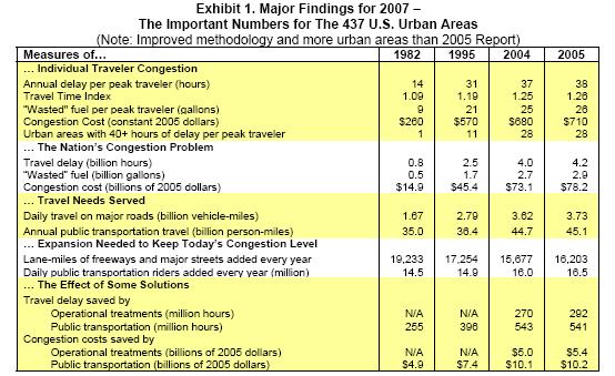
7 TTI Congestion Index
8
9
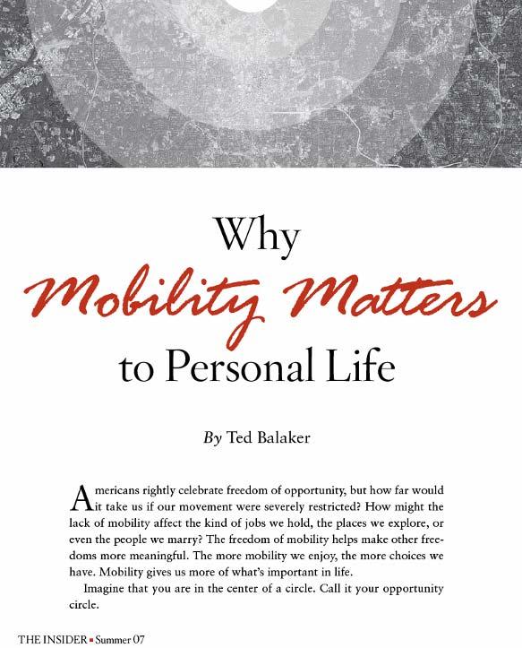
10 Why Mobility Matters (to personal life and in the context of transportation planning) It provides: - potential for movement, - ability to get from one place to another - ability to move around Measures: - level-of-service - higher volume-to-capacity ratios Predominant Policy Solutions
11
12
13 Measurement / Evaluation Criteria: Focus on Urban Areas Performance measures (how are we doing?) Captures pressing needs Transportation & Land Use? Synergistically addresses: opportunities demand function behavior
14 Accessibility: Ease by which destinations can be reached j A im = O j f (C ijm ) A im = accessibility at i by mode m 1. O j = opportunities at j 2. C = measure of travel cost 3. ij m = measure of the ease or attractiveness of travel between i & j Knowing travel times Knowing behaviors
15 Accessibility opens additional policy prescriptions 1a. Build Infrastructure 1b. Enhance service &/or infrastructure 2a. Intensify land use 2b. Change land use
16
17
18
19 Source: League of American Bicyclists

20 Source: League of American Bicyclists

21 Source: League of American Bicyclists
22
23
24 Source: Don Shoup

25 Source: Don Shoup


26 Accessibility opens additional policy prescriptions 1a. Build Infrastructure 1b. Enhance service &/or infrastructure 2a. Intensify land use 2b. Change land use
27 1995 Jobs Schools Parks Shopping Automobile 2000Transit Jobs Schools Parks Shopping Automobile Bicycling Transit Walking 2005 Jobs Schools Parks Shopping Automobile Bicycling Transit Walking Bicycling Walking
28
29
30 Distance Decay: Walking 40% 30% Work Shopping Restaurant Entertainment Expon. (Work) Expon. (Entertainment) Expon. (Shopping) Expon. (Restaurant) Percent of Trips 20% 10% 0% Distance (km)
31 Distance Decay: Bicycling 50% 40% 30% Work Shopping School Entertainment Trail Expon. (Work) Expon. (Shopping) Expon. (School) Expon. (Entertainment) Expon. (Trail) Percent of Trips 20% 10% 0% Distance (km)
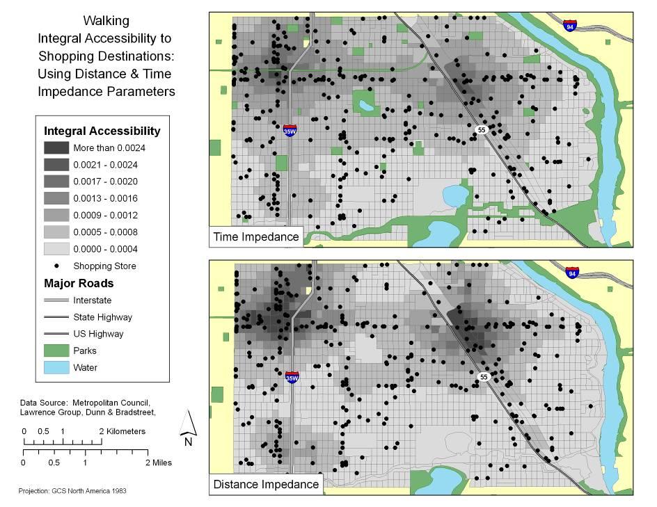
32 Impedance Functions Distance Time Work Walk y =.486e x y =.511e -.106x Bike y =.402e -.203x y =.146e -.040x Transit y =.667e -.093x y = e -.1*t_min Shopping W y =.469e x y =.368e -.094x B y =.343e -.514x y =.434e -.107x T y =.346e -.092x y = e -.1*t_min School W y = e -.1*t_dist y =.524e -.106x B y =.458e -.122x y =.424e -.100x T y =.406e -.116x y = e -.1*t_min Restaurant W y =.388e x y =.373e -.093x B y = e -.1*t_min T y = e -.1*t_min Recreation W y =.327e -.769x y =.556e -.100x B y =.367e -.375x y =.293e -.071x T y = e -.1*t_min

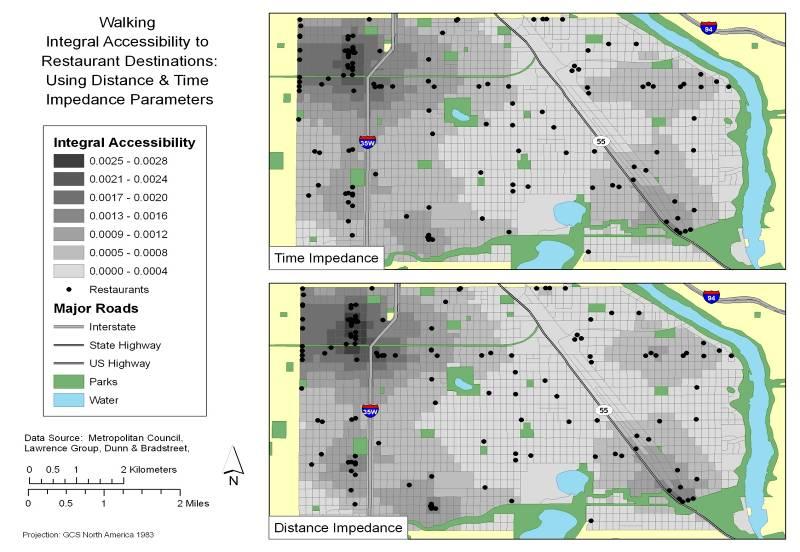
33 1995 Restaurant Accessibility by Bicycle
34 2000 Restaurant Accessibility by Bicycle
35 2005 Restaurant Accessibility by Bicycle

36 1995 Retail Accessibility by Walking

37 2000 Retail Accessibility by Walking

38 2005 Retail Accessibility by Walking
39 2000 Restaurant Accessibility by Bicycle 2000 Restaurant Accessibility by Bicycle

40 2005 Restaurant Accessibility by Bicycle
 1995 Retail Accessibility by")
41 1995 Retail Accessibility by Transit (bw 4:00 4:15) 1995 Retail Accessibility by Transit
42 2000 Retail Accessibility by Transit (bw 4:00 4:15) 2000 Retail Accessibility by Transit
 2005 Retail Accessibility by")
43 2005 Retail Accessibility by Transit (bw 4:00 4:15) 2005 Retail Accessibility by Transit

44 2000 retail opportunity

45 2005 retail opportunity
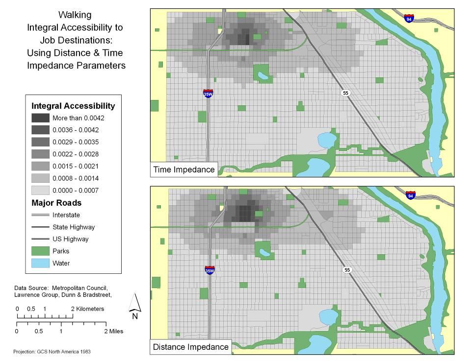
46 1995 Employment Accessibility by Transit 1995 employ transit

47 2000 Employment Accessibility by Transit 2000 employ transit
48 2005 Employment Accessibility by Transit employ transit
49
50 What we now can understand? Robust measures for measuring the performance of urban areas Measures can account for: Mode Destinations Demand Understand performance vis-à-vis array of policy prescriptions
51 Kevin J. Krizek University of Colorado
52 Employment (# of employees) Retail (overall annual sales of establishment) Restaurant (same) Public park access (sqm of park) Elementary (MCA test scores)
53 Questions How many block groups? What does the impedance function mean What is the significance of if/how/when they are measured differently? 6 am to 9pm (in 15 min increments) 60 intervals What was the bicycling cut off? What was the walking cut off? Transit restrictions?
54 Simplifying Dealing with 120 min bicycle cut off 5 mile walking cut off 1 transit transfer Using some decay functions

55 1995 Employment Accessibility by Transit (bw 4:00 4:15)
56 2000 Employment Accessibility by Transit (bw 4:00 4:15)

57 2005 Employment Accessibility by Transit (bw 4:00 4:15)
58 a L O T of D A T A Census blocks 42,240 of them Assumptions Transit frequency Cyclist distance Walking distance
59 Units are in minutes
60 What destinations? Mode Shopping Neighborhood retail Employment Recreatio n/ Parks Education -University -Primary Entertainme nt (includes bars) Gym/Heal th Club Airport Restaurant Walk Bicycle Transit Auto
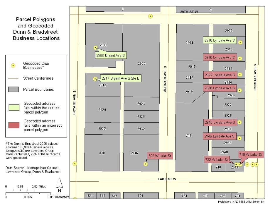
 Records for 135,928 Metro area businesses Detailed business data includes: Location Industry classification (NAICS and SICS) Sales")
61 Data Sources for Land use Database Metropolitan Council Land use Parcel points and polygons Dunn & Bradstreet Business locations and types (2005) Records for 135,928 Metro area businesses Detailed business data includes: Location Industry classification (NAICS and SICS) Sales Employees
62 General Destination Categories Shopping Food, Groceries, and Restaurants Fitness and Recreation Entertainment Education Health Care Parks Post Offices Financial Services Other Personal Services Professional Services Airports Transportation Other Based on North American Industrial Classification System codes and land use classification
63 Example of Specific Destinations Food, Groceries, and Restaurants Supermarkets and Grocery Stores (Retail, 5-digit) Convenience Stores (Retail, 5-digit) Warehouse Clubs and Supercenters (Retail, 5-digit) Specialty Food Stores (Retail, Manufacturing, 6-digit) Full-Service Restaurant (Accommodation & Food Service, 6-digit) Snack and Nonalcoholic Beverage Bars (i.e. coffee shops) (Accommodation & Food Service, 6-digit) Other Food Service (Accommodation & Food Service, 4-digit) Bars/Nightclubs (Accommodation & Food Service, 4-digit) (NAICS industries and level of disaggregation used in parenthesis)

64 Data Cleaning Fixed Records - Many misspellings & abbreviations - Assign street address to mall businesses Removed Records P.O. Boxes - 8,377 Not in 7-County Metro Area - 7,000 Bad / Missing Address Data (no zip code, street name, building number, etc.)
65
66 Understanding Measures of Accessibility they are: Relative to Mode specific Destination specific

67 Matching Summary

68 Detailed Land Use Data
69 but is Accessibility all about supply? NO! A hypothetical Ideally, accessibility measures should incorporate BOTH supply AND demand.
70 Estimating Decay Functions Fitting decay curves Modes: Auto, transit, bike, walk Purposes: Work, shopping, school, restaurant, recreation, trail access (bicycling)
71 Functional Form Types of decay functions Negative power: f(c) = c (-β) Negative exponential: f(c) = e (-βc) Combined: f(c) = c (α) e (-βc) We focus on the negative exponential function Definition of impedance Time vs. network distance

72 Flexible Forms
73 Impedance: Distance vs. Time Both have limitations as impedance measures Distance Cannot validate route choice, shortest path Difficult to validate speeds Time Duration data are self-reported, subject to perception error
74 Data Sources 4 Data sources used for analysis in Twin Cities: Met Council TBI HIS files Met Council transit on-board survey Hennepin County trail use survey Non-Motorized Pilot Project (NMPP) survey
75 Work Shopping School Distance Time Distance Time Distance Time Walk y =.486e x y =.511e -.106x y =.469e x y =.368e -.094x y =.524e -.106x Bike y =.402e -.203x y =.146e -.040x y =.343e -.514x y =.434e -.107x y =.458e -.122x y =.424e -.100x Transit y =.667e -.093x y =.346e -.092x y =.406e -.116x Drive Alone y =.504e -.088x y =.379e -.117x y =.371e -.122x Shared Ride y =.237e -.076x y =.381e -.130x y =.160e -.096x Notes: 1) For impedance functions where distance is the measure of separation, kilometers are the relevant units. Where time is the measure of separation, units are in minutes. 2) The dependent variable (y) measures the fraction of trips covering a given distance. 3) All grayed cells represent impedance functions that could not be estimated due to limited data. 4) Cells shaded blue can be calculated given available data, but have not been needed thus far. 5) Cells shaded red represent the recently acquired health care data. An impedance function can be calculated with these data, but the mode cannot be specified. Restaurant Recreation Trail Access Health Care Distance Time Distance Time Distance Time Distance Time y =.388e x y =.373e -.093x y =.327e -.769x y =.556e -.100x y =.367e -.375x y =.293e -.071x y =.119e -.333x y =.318e -.119x y =.426e -.140x y =.336e -.103x y =.333e -.093x


76 Impedance Functions e -0.1*dist_m e -0.1*t_min e -0.1*t_min e -0.1*t_min e -0.1*t_min e -0.1*t_min e -0.1*t_min
77
78 How we proceeded New networks GIS street layer; assumptions about speeds New zones Census block level Detailed land use/activity data Parcel-level land use merged with: Establishment level (D & B) business data Contains location, sales, employment, industrial classification
79
80
81
82
83
84 What s unique about measuring access for Transit, Walking, Cycling? Peculiarities: -Scale of analysis -Availability of data Balance: Useful measures w/ policy relevance Robust & reliable science
85 Accessibility: a HOT topic in policy circles has the potential to radically inform how we think about the structure of metropolitan areas loosely throw around terms and concepts without further refinement, however, run the risk of focusing on a topic w/o much meaning
Exhibit 1 PLANNING COMMISSION AGENDA ITEM
 Exhibit 1 PLANNING COMMISSION AGENDA ITEM Project Name: Grand Junction Circulation Plan Grand Junction Complete Streets Policy Applicant: City of Grand Junction Representative: David Thornton Address:
Kevin Manaugh Department of Geography McGill School of Environment
 Kevin Manaugh Department of Geography McGill School of Environment Outline Why do people use active modes? Physical (Built environment) Factors Psychological Factors Empirical Work Neighbourhood Walkability
APPENDIX E BIKEWAY PRIORITIZATION METHODOLOGY
 APPENDIX E BIKEWAY PRIORITIZATION METHODOLOGY INTRODUCTION The network of bikeways recommended in the Bicycle Master Plan is extensive and is likely to be only partially completed during the 25-year life
92% COMMUTING IN THE METRO. Congested Roadways Mode Share. Roadway Congestion & Mode Share
 COMMUTING IN THE METRO Roadway Congestion & Mode Share The majority of major roadways in Greater Des Moines are without congestion and have underutilized capacity. This surplus capacity could be used for
Operationalizing Accessibility
 Operationalizing Accessibility March 30, 2017 Chris McCahill State Smart Transportation Initiative Matt Pettit Citilabs State Smart Transportation Initiative A network of reform-oriented state DOTs, founded
2010 Pedestrian and Bicyclist Special Districts Study Update
 2010 Pedestrian and Bicyclist Special Districts Study Update Pedestrian and Bicyclist Special Districts Program Overview H-GAC s Special Districts Program aims to provide strategic investments in pedestrian
Eric Sundquist Managing Director State Smart Transportation Initiative (SSTI) Urban Sustainability Accelerator
 Urban Sustainability Accelerator") New tools for making better transportation system decisions Eric Sundquist Managing Director State Smart Transportation Initiative (SSTI) Urban Sustainability Accelerator Accessibility and trip-making
New tools for making better transportation system decisions Eric Sundquist Managing Director State Smart Transportation Initiative (SSTI) Urban Sustainability Accelerator Accessibility and trip-making
NM-POLICY 1: Improve service levels, participation, and options for non-motorized transportation modes throughout the County.
 Transportation PRINCE WILLIAM COUNTY 2008 COMPREHENSIVE PLAN NON-MOTORIZED PLAN CONTENTS Goals, Policies, and Action Strategies Table 4 (Bike Facility Classifications and Descriptions) Table 5 (Bike Facility
Introduction to Sugar Access. Sugar Access - Measuring Accessibility (Robert Kohler, Citilabs) Slide 1 of 21
 Slide 1 of 21") Introduction to Sugar Access Sugar Access - Measuring Accessibility (Robert Kohler, Citilabs) Slide 1 of 21 Walkability, Livability, Accessibility http://www.citilabs.com/sugaraccess Sugar Access - Measuring
Introduction to Sugar Access Sugar Access - Measuring Accessibility (Robert Kohler, Citilabs) Slide 1 of 21 Walkability, Livability, Accessibility http://www.citilabs.com/sugaraccess Sugar Access - Measuring
San Mateo County Comprehensive Bicycle and Pedestrian Plan Open House
 San Mateo County Comprehensive Bicycle and Pedestrian Plan Open House October 28, 2010 Presented to San Mateo County residents and interested parties by Lauren Ledbetter, Alta Planning + Design Matt Haynes,
The Impact of Placemaking Attributes on Home Prices in the Midwest United States
 The Impact of Placemaking Attributes on Home Prices in the Midwest United States 2 0 1 3 C O N S T R U C T E D E N V I R O N M E N T C O N F E R E N C E M A R Y B E T H G R A E B E R T M I C H I G A N
Tulsa Metropolitan Area LONG RANGE TRANSPORTATION PLAN
 Tulsa Metropolitan Area LONG RANGE TRANSPORTATION PLAN Indian Nations Council of Governments August 2005 CONTACTING INCOG In developing the Destination 2030 Long Range Transportation Plan, INCOG s Transportation
Bicycle Demand Forecasting for Bloomingdale Trail in Chicago
 Bicycle Demand Forecasting for Bloomingdale Trail in Chicago Corresponding Author: Zuxuan Deng Arup Water Street, New York, NY 000 zuxuan.deng@arup.com Phone:.. Fax:..0 Matthew Sheren Arup Water Street,
Bike Routes Assessment: 95 Ave, 106 St & 40 Ave. Replace with appropriate image in View > Master.
 Bike Routes Assessment: 95 Ave, 106 St & 40 Ave Replace with appropriate image in View > Master. Transportation Committee October 15, 2014 City Council Direction What we are trying to achieve The Way Ahead:
Webinar: Development of a Pedestrian Demand Estimation Tool
 Portland State University PDXScholar TREC Webinar Series Transportation Research and Education Center (TREC) 2-18-2016 Webinar: Development of a Pedestrian Demand Estimation Tool Kelly Clifton Portland
CONNECTING PEOPLE TO PLACES
 CONNECTING PEOPLE TO PLACES 82 EAST BENCH MASTER PLAN 07 Introduction The East Bench transportation system is a collection of slow moving, treelined residential streets and major arteries that are the
Roadway Bicycle Compatibility, Livability, and Environmental Justice Performance Measures
 Roadway Bicycle Compatibility, Livability, and Environmental Justice Performance Measures Conference on Performance Measures for Transportation and Livable Communities September 7-8, 2011, Austin, Texas
June 3, Attention: David Hogan City of San Mateo 330 W. 2oth Avenue San Mateo, CA 94403
 June 3, 2015 Attention: David Hogan City of San Mateo 330 W. 2oth Avenue San Mateo, CA 94403 Regarding: PA # 15-030, Bridgepointe Shopping Center 2202 Bridgepointe Parkway, APN 035-466-10 Dear David: Enclosed
TRANSIT & NON-MOTORIZED PLAN DRAFT FINAL REPORT Butte County Association of Governments
 1 INTRODUCTION Maintaining a high quality of life is the essence of this plan for transit and non-motorized transportation in Butte County. Curbing greenhouse gas emissions (GHG) by reducing congestion,
Chapter 14 PARLIER RELATIONSHIP TO CITY PLANS AND POLICIES. Recommendations to Improve Pedestrian Safety in the City of Parlier (2014)
") Chapter 14 PARLIER This chapter describes the current status and future plans for biking and walking in the City of Parlier. RELATIONSHIP TO CITY PLANS AND POLICIES The Parlier General Plan is the primary
Chapter 14 PARLIER This chapter describes the current status and future plans for biking and walking in the City of Parlier. RELATIONSHIP TO CITY PLANS AND POLICIES The Parlier General Plan is the primary
PRINCE GEORGE S PLAZA METRO AREA PEDESTRIAN PLAN
 PRINCE GEORGE S PLAZA METRO AREA PEDESTRIAN PLAN May 28, 2008 Agenda Welcome and introductions Project overview and issue identification Planning context and strengths Design challenges and initial recommendations
CITY OF BLOOMINGTON COMPLETE STREETS POLICY
 CITY OF BLOOMINGTON COMPLETE STREETS POLICY POLICY OBJECTIVE: The City of Bloomington will enhance safety, mobility, accessibility and convenience for transportation network users of all ages and abilities,
Transportation Master Plan Advisory Task Force
 Transportation Master Plan Advisory Task Force Network Alternatives & Phasing Strategy February 2016 BACKGROUND Table of Contents BACKGROUND Purpose & Introduction 2 Linking the TMP to Key Council Approved
Hennepin County Pedestrian Plan Public Comment Report
 Hennepin County Pedestrian Plan Public Comment Report On May 31, 2013, the draft Hennepin County Pedestrian Plan was released for a 45-day public comment period ending July 15, 2013. The county received
Introduction. Mode Choice and Urban Form. The Transportation Planner s Approach. The problem
 Introduction The table below shows transit s share in the urban US (all trip purposes) and the 10 urban areas where it is most popular (2008 data): Mode Choice and Urban Form Philip A. Viton April 4, 2014
BICYCLE SHARING SYSTEM: A PROPOSAL FOR SURAT CITY
 BICYCLE SHARING SYSTEM: A PROPOSAL FOR SURAT CITY Vishal D. Patel 1, Himanshu J. Padhya 2 M.E Student, Civil Engineering Department, Sarvajanik College of Engineering and Technology, Surat, Gujarat, India
Planning Guidance in the 2012 AASHTO Bike Guide
 Planning Guidance in the 2012 AASHTO Bike Guide Presentation by: RJ Eldridge Peter Lagerwey August 22, 2012 WEBINAR 2: PLANNING GUIDANCE IN THE 2012 AASHTO BIKE GUIDE Today s Webinar Significant Updates
SANTA CLARA COUNTYWIDE BICYCLE PLAN August 2008
 SANTA CLARA COUNTYWIDE BICYCLE PLAN August 2008 To assist VTA and Member Agencies in the planning, development and programming of bicycle improvements in Santa Clara County. Vision Statement To establish,
Applying Bi-objective Shortest Path Methods to Model Cycle Route-choice
 Applying Bi-objective Shortest Path Methods to Model Cycle Route-choice Chris Van Houtte, Judith Y. T. Wang, and Matthias Ehrgott September 30, 2009 Outline Commuter Cyclists Motivation Choice Set Route
Identification of Bicycle Demand from Online Routing Requests
 445 Identification of Bicycle Demand from Online Routing Requests Hartwig H. HOCHMAIR Abstract Governments at all levels aim to increase cycling and walking within the mix of transportation modes. Accurate
CPC Parking Lot Riverside Drive. Transportation Rationale
 CPC Parking Lot Transportation Rationale Prepared By: NOVATECH Suite 200, 240 Michael Cowpland Drive Ottawa, Ontario K2M 1P6 September 2015 Novatech File: 114093 Ref: R-2015-153 Table of Contents 1.0 INTRODUCTION...
Sixth Line Development - Transit Facilities Plan
 Memorandum Date: November 13, 2012 To: From: c.c. Subject: Rob Freeman (Freeman Planning) Kevin Phillips Sixth Line Development - Transit Facilities Plan 33016631 This memo was prepared to review the transit
The previous chapters in this plan have established the value of this plan (Chapter 1), the
, the") 4 Making Madison an Even Better Place to Walk: Vision, Goals, Objectives The previous chapters in this plan have established the value of this plan (Chapter 1), the importance of walking (Chapter 2), and
4 Making Madison an Even Better Place to Walk: Vision, Goals, Objectives The previous chapters in this plan have established the value of this plan (Chapter 1), the importance of walking (Chapter 2), and
Bicycle and Pedestrian Connectivity Study. Old Colony Planning Council
 Bicycle and Pedestrian Connectivity Study Old Colony Planning Council Outline Why consider bike/peds in road designs? Why are measures needed? Connecting Land Use with Transportation Evaluation Tools:
Memorandum. Drive alone
 Memorandum To: Cc: From: Kimberly Kerr, Assistant Chief Administrative Officer Natalie Porter, PE, TE Shawna Purvines Claudia Wade, PE Michael Schmitt, AICP CTP, PTP Re: Technical Memorandum #2: Model
Madison Urban Area and Dane County. Bicycle Transportation Plan Summary. September Introduction. Bicycle Plan Scope and Planning Process
 Bicycle Transportation Plan Summary Madison Urban Area and Dane County Introduction September 2000 Bicycling is an important mode of transportation in the Madison urban area and countywide that is available
MAG Town of Cave Creek Bike Study Task 6 Executive Summary and Regional Significance Report
 Page 1 MAG Town of Cave Creek Bike Study Task 6 Executive Summary and Regional Significance Report August 1, 2012 MAG Project #481 Page 2 Task 6 Executive Summary and Regional Significance Report Introduction
Public Meeting #1 January 30, 2018
 Public Meeting #1 January 30, 2018 Meeting Outline Mayor s Introduction Presentation Q&A Group Activities Wrap-up Presentation Outline Introduction Existing Conditions Market Assessment Break-out Setup
Asking the Right Questions About Transportation and Land Use
 Getting There: Access and the Future of the Twin Cities Region Asking the Right Questions About Transportation and Land Use Access to Destinations Study Research Summary No. 1 March 2007 CTS 07-03 Preface
Guidelines for Providing Access to Public Transportation Stations APPENDIX C TRANSIT STATION ACCESS PLANNING TOOL INSTRUCTIONS
 APPENDIX C TRANSIT STATION ACCESS PLANNING TOOL INSTRUCTIONS Transit Station Access Planning Tool Instructions Page C-1 Revised Final Report September 2011 TRANSIT STATION ACCESS PLANNING TOOL INSTRUCTIONS
NACTO Designing Cities Conference Project Evaluation: Tools for Measuring Success and Building Support. October 29, 2015
 NACTO Designing Cities Conference Project Evaluation: Tools for Measuring Success and Building Support October 29, 2015 The case for evaluation: Have a social contract with City Council, staff and community
CHAPTER 1 INTRODUCTION
 CHAPTER 1 INTRODUCTION Chapter Table of Contents THE 2017 HOUSTON BIKE PLAN 1-1 HOUSTON BIKEWAYS PROGRAM 1-2 HISTORY OF BICYCLE PLANNING IN HOUSTON 1-3 BICYCLE LEVEL OF COMFORT 1-3 EXISTING PLANS, PROGRAMS
Pedestrian Demand Modeling: Evaluating Pedestrian Risk Exposures
 Pedestrian Demand Modeling: Evaluating Pedestrian Risk Exposures Kelly J. Clifton National Center for Smart Growth University of Maryland May 19, 2008 Study Team University of Maryland National Center
Regional Bicycle Barriers Study
 Regional Bicycle Barriers Study Executive Summary Background and Purpose The 2040 Transportation Policy Plan (TPP) sets policies for planning and investment direction in the transportation system in the
Summary Report: Built Environment, Health and Obesity
 Research and education Built Environment Edmonton Project Summary Report: Built Environment, Health and Obesity Introduction In 2007 the Canadian Institutes of Health Research and the Heart and Stroke
GIS Based Data Collection / Network Planning On a City Scale. Healthy Communities Active Transportation Workshop, Cleveland, Ohio May 10, 2011
 The Purpose of GIS Based Network Planning GIS Based Data Collection / Network Planning Healthy Communities Active Transportation Conference Tuesday, May 10, 2011 10:00 AM Norman Cox, LLA, ASLA. Ann Arbor,
City of Novi Non-Motorized Master Plan 2011 Executive Summary
 City of Novi Non-Motorized Master Plan 2011 Executive Summary Prepared by: February 28, 2011 Why Plan? Encouraging healthy, active lifestyles through pathway and sidewalk connectivity has been a focus
GIS Based Non-Motorized Transportation Planning APA Ohio Statewide Planning Conference. GIS Assisted Non-Motorized Transportation Planning
 The Purpose of GIS Assisted Network GIS Assisted Non-Motorized Transportation 2011 APA Ohio Statewide Conference Friday, 10:45 AM to Noon Focus on near-term projects wwwgreenwaycollabcom The purpose of
NEWS-CFA: Confirmatory Factor Analysis Scoring for Neighborhood Environment Walkability Scale (Updated: March 15, 2011)
") NEWS-CFA: Confirmatory Factor Analysis Scoring for Neighborhood Environment Walkability Scale (Updated: March 15, 2011) The NEWS is a self-report perceived environment survey originally developed by Saelens
NEWS-CFA: Confirmatory Factor Analysis Scoring for Neighborhood Environment Walkability Scale (Updated: March 15, 2011) The NEWS is a self-report perceived environment survey originally developed by Saelens
El Paso County 2040 Major Transportation Corridors Plan
 El Paso County 2040 Major Transportation Corridors Plan Connect-our-County Online Transportation User Survey Preliminary Results June 24, 2010 Years of Residence 2. How many years have you LIVED HERE?
21.07 TRANSPORT CONNECTIVITY AND INFRASTRUCTURE
 21.07 TRANSPORT CONNECTIVITY AND INFRASTRUCTURE 21.07-1 Connectivity and Choice Transport connectivity and mode choice are critical to achieving productive, sustainable and socially just cities. Travel
Agenda. Overview PRINCE GEORGE S PLAZA METRO AREA PEDESTRIAN PLAN
 PRINCE GEORGE S PLAZA METRO AREA PEDESTRIAN PLAN May 28, 2008 Agenda Welcome and introductions Project overview and issue identification Planning context and strengths Design challenges and initial recommendations
Creating walkable, bikeable and transit-supportive communities in Halton
 Creating walkable, bikeable and transit-supportive communities in Halton By presenting current research and best practices, the information in this paper is meant to support and broaden discussion on how
WHITE PAPER: TRANSIT SERVICE FOR SOUTH SHAGANAPPI
 9/27/2012 TRANSIT PLANNING WHITE PAPER: TRANSIT SERVICE FOR SOUTH SHAGANAPPI 2012 Calgary Transit 1 Table of Contents Purpose... 3 Area of Change... 3 Background... 3 Access to destinations... 5 Connecting
LEED Pilot Credit Library
 Pilot Credit 13: Bicycle Network, Storage, and Shower Rooms Applicable Rating Systems >> Requirements >> Submittals >> Additional Questions >> Background Information >> Changes >> Applicable Rating Systems
A Traffic Operations Method for Assessing Automobile and Bicycle Shared Roadways
 A Traffic Operations Method for Assessing Automobile and Bicycle Shared Roadways A Thesis Proposal By James A. Robertson Submitted to the Office of Graduate Studies Texas A&M University in partial fulfillment
WILMAPCO Public Opinion Survey Summary of Results
 Wilmington Area Planning Council WILMAPCO Public Opinion Survey Summary of Results Prepared by: 2955 Valmont Road, Suite 300 Boulder, Colorado 80301 t: 303-444-7863 f: 303-444-1145 www.n-r-c.com Table
El Centro Mobility Hub
 The El Centro drive shed comprises a major portion of the El Centro downtown area, which is well served by bus routes. The proposals intend to promote use of public transit through improvements and enhancements
REGIONAL HOUSEHOLD TRAVEL SURVEY:
 Defining the Vision. Shaping the Future. REGIONAL HOUSEHOLD TRAVEL SURVEY: Profile Why we travel How we travel Who we are and how often we travel When we travel Where we travel How far and how long we travel
NASHUA REGIONAL PLANNING COMMISSION REGIONAL BICYCLE AND PEDESTRIAN PLAN
 NASHUA REGIONAL PLANNING COMMISSION REGIONAL BICYCLE AND PEDESTRIAN PLAN June, 2005 Prepared by the Nashua Regional Planning Commission 2005 NRPC Regional Bicycle and Pedestrian Plan- JUNE 2005 ACKNOWLEDGEMENTS
Connecting cyclists to work. Syracuse Metropolitan Transportation Council
 Connecting cyclists to work Syracuse Metropolitan Transportation Council Overview Prepared at request: NYS Department of Transportation (NYSDOT) Project Achievements Target group Purpose Process Recommendations
We support several of Regional Municipality of Durham Transportation Master Plan Directions such as
 OATAC-17-26 Relates to Item 1 of the O.A.T.A.C. Report (DS-17-164) We support several of Regional Municipality of Durham Transportation Master Plan Directions such as Direction 3: Make walking and cycling
COLUMBUS AVENUE NEIGHBORHOOD TRANSPORTATION STUDY
 COLUMBUS AVENUE NEIGHBORHOOD TRANSPORTATION STUDY Pedestrian Survey Findings Survey Main Findings: Transit and walking are the main two modes used by both visitors and residents of the area, regardless
TOWN OF PORTLAND, CONNECTICUT COMPLETE STREETS POLICY
 TOWN OF PORTLAND, CONNECTICUT COMPLETE STREETS POLICY I. VISION, GOALS & PRINCIPLES VISION To improve the streets of Portland making them safer and more accessible for all users including pedestrians,
Key objectives of the survey were to gain a better understanding of:
 3 COMMUNITY INPUT Community input is an essential part of corridor studies. For the SR 87 corridor study, VTA staff conducted an extensive online survey of people living and commuting along the corridor.
Transport attitudes, residential preferences, and urban form effects on cycling and car use.
 Downloaded from orbit.dtu.dk on: Mar 10, 2019 Transport attitudes, residential preferences, and urban form effects on cycling and car use. Nielsen, Thomas Alexander Sick; Olafsson, Anton Stahl; Carstensen,
University of Victoria Campus Cycling Plan Terms of Reference. 1.0 Project Description
 University of Victoria Campus Cycling Plan Terms of Reference 1.0 Project Description The Campus Cycling Plan, a first for the University, will provide a comprehensive and coordinated approach to support
Property Owner Survey Results
 Property Owner Survey Results 1. What are the most positive aspects of the Golden Mile? (check all that apply) Response Response Existing mix of businesses 50.0% 20 Good access to major roads 85.0% 34
Chapter 2. Bellingham Bicycle Master Plan Chapter 2: Policies and Actions
 Chapter 2 Bellingham Bicycle Master Plan Chapter 2: Policies and Actions Chapter 2: Policies and Actions The Bicycle Master Plan provides a road map for making bicycling in Bellingham a viable transportation
Measuring and Communicating Mobility:
 Measuring and Communicating Mobility: The District Mobility Project Stephanie Dock, District Department of Transportation TRB Transportation Issues in Major Cities Committee May 2, 2017 Deconstructing
Temporal and Spatial Variation in Non-motorized Traffic in Minneapolis: Some Preliminary Analyses
 Temporal and Spatial Variation in Non-motorized Traffic in Minneapolis: Some Preliminary Analyses Spencer Agnew, Jason Borah, Steve Hankey, Kristopher Hoff, Brad Utecht, Zhiyi Xu, Greg Lindsey Thanks to:
Midtown Corridor Alternatives Analysis
 Midtown Corridor Alternatives Analysis Ridership Forecast Methodology and Results December 2013 Prepared by the SRF Consulting Group Team for Table of Contents Introduction... 1 Methodology... 1 Assumptions...
Preliminary Transportation Analysis
 Preliminary Transportation Analysis Goals of a Robust, Multimodal Transportation Network Safe Accessible/Connected Efficient Comfortable Context-Sensitive Motor Vehicle: Continue to analyze the data to
Do New Bike Share Stations Increase Member Use?: A Quasi-Experimental Study
 Do New Bike Share Stations Increase Member Use?: A Quasi-Experimental Study Jueyu Wang & Greg Lindsey Humphrey School of Public Affairs University of Minnesota Acknowledgement: NSF Sustainable Research
Proposed. City of Grand Junction Complete Streets Policy. Exhibit 10
 Proposed City of Grand Junction Complete Streets Policy Exhibit 10 1 City of Grand Junction Complete Streets Policy Vision: The Complete Streets Vision is to develop a safe, efficient, and reliable travel
Categorizing Cyclists: What Do We Know? Insights from Portland, OR
 Categorizing Cyclists: What Do We Know? Insights from Portland, OR Jennifer Dill, Ph.D. Professor, Urban Studies & Planning Director, Oregon Transportation Research & Education Consortium (OTREC) Portland
Hamilton Transportation Master Plan Public Consultation. Public Information Centre One Summary
 Hamilton Transportation Master Plan Public Consultation Public Information Centre One Summary Table of Contents Introduction 1 Purpose 2 What Was Presented 2 Who Came to the Meeting 2 The Breakout Sessions
Gardiner East. Gardiner Expressway & Lake Shore Boulevard Reconfiguration Environmental Assessment & Urban Design Study
 Gardiner East Gardiner Expressway & Lake Shore Boulevard Reconfiguration Environmental Assessment & Urban Design Study Press Conference February 5, 2014 1 What area are we studying? 2 Gardiner East in
NOTICE OF AVAILABILITY/NOTICE OF COMMENT PERIOD OF A DRAFT EIR/EIS/EIS FOR PUBLIC REVIEW AND HEARINGS
 Tahoe Transportation District 128 Market Street, Suite 3F Stateline, NV 89449 Phone: (775) 589-5500 www.tahoetransportation.org Federal Highway Administration 650 Capitol Mall, Suite 4-100 Sacramento,
THE 2010 MSP REGION TRAVEL BEHAVIOR INVENTORY (TBI) REPORT HOME INTERVIEW SURVEY. A Summary of Resident Travel in the Twin Cities Region
 REPORT HOME INTERVIEW SURVEY. A Summary of Resident Travel in the Twin Cities Region") THE 2010 MSP REGION TRAVEL BEHAVIOR INVENTORY (TBI) REPORT HOME INTERVIEW SURVEY A Summary of Resident Travel in the Twin Cities Region October 2013 WHAT IS THE TBI? The Travel Behavior Inventory (TBI)
THE 2010 MSP REGION TRAVEL BEHAVIOR INVENTORY (TBI) REPORT HOME INTERVIEW SURVEY A Summary of Resident Travel in the Twin Cities Region October 2013 WHAT IS THE TBI? The Travel Behavior Inventory (TBI)
Traffic Safety Barriers to Walking and Bicycling Analysis of CA Add-On Responses to the 2009 NHTS
 Traffic Safety Barriers to Walking and Bicycling Analysis of CA Add-On Responses to the 2009 NHTS NHTS Users Conference June 2011 Robert Schneider, Swati Pande, & John Bigham, University of California
RESOLUTION NO ?? A RESOLUTION OF THE CITY OF NEPTUNE BEACH ADOPTING A COMPLETE STREETS POLICY
 RESOLUTION NO. 2018-?? A RESOLUTION OF THE CITY OF NEPTUNE BEACH ADOPTING A COMPLETE STREETS POLICY WHEREAS, safe, convenient, and accessible transportation for all users is a priority of the City of Neptune
Appendix C. Corridor Spacing Research
 Appendix C. Corridor Spacing Research Task 3 of the Twin Cities Bicycle Study called for the development of bicycle corridor spacing guidelines. This section summarizes research of the spacing of planned
Strategic Plan for Active Mobility Phase I: Bicycle Mobility
 Strategic Plan for Active Mobility Phase I: Bicycle Mobility City of Corpus Christi February 9, 2016 Jeff Pollack, AICP Transportation Planning Director Vision Active Mobility Plan Vision The metropolitan
Clackamas County Comprehensive Plan
 ROADWAYS The County s road system permits the movement of goods and people between communities and regions, using any of a variety of modes of travel. Roads provide access to virtually all property. They
PEDALING FORWARD. A Glance at the SFMTA s Bike Program for SFMTA.COM
 PEDALING FORWARD A Glance at the SFMTA s Bike Program for 2017-2021 SFMTA.COM INTRODUCTION About This Booklet More people from all walks of life see their bicycle as a more convenient way to get where
Anne Arundel County BICYCLE, PEDESTRIAN, TRANSIT ASSESSMENT GUIDELINES
 Anne Arundel County BICYCLE, PEDESTRIAN, TRANSIT ASSESSMENT GUIDELINES December 2018 TABLE OF CONTENTS I. Executive Summary 3 II. When Is A Bicycle Pedestrian Transit Assessment (BPTA) Required? 4 III.
Engagement Summary: Round 1
 Engagement Summary: Round 1 June 21, 2018 REPORT FOR: City of Courtenay 830 Cliff Avenue Courtenay, BC V9N 2J7 PREPARED BY: Urban Systems Ltd. 550 1090 Home Street Vancouver, BC V6B 2W9 ALONG WITH: Kathleen
Mumford Terminal Replacement Opportunities Neighbourhood Open House. we are here. PHASE 2 Identifying and Evaluating Candidate Sites
 Welcome Replacement Opportunities Neighbourhood Open House. AGENDA PURPOSE 1. REVIEW the information boards 2. DISCUSS aspects of the project with the project team 3. SHARE your thoughts on replacement
Chapter 9: Pedestrians and Bicyclists
 Chapter 9: Pedestrians and Bicyclists Walking and bicycling are essential modes of transportation. These modes allow people to travel without contributing to congestion and air pollution, to access other
Living Streets Policy
 Living Streets Policy Introduction Living streets balance the needs of motorists, bicyclists, pedestrians and transit riders in ways that promote safety and convenience, enhance community identity, create
A New Approach in the GIS Bikeshed Analysis Considering of Topography, Street Connectivity, and Energy Consumption
 A New Approach in the GIS Bikeshed Analysis Considering of Topography, Street Connectivity, and Energy Consumption ACSP Conference, Cincinnati, OH November 1, 2012 Hiroyuki Iseki, Ph.D. & Matthew Tingstrom
Rochester Downtown Bicycle Study 2009
 Rochester Downtown Bicycle Study 2009 Relationship of ROCOG Long Range Transportation Plan to Rochester Comprehensive Plan Regional Long Range Transportation Plan (LRTP) is prepared under the auspices
Gordon Proctor Director Policy on Accommodating Bicycle and Pedestrian Travel on ODOT Owned or Maintained Facilities
 Approved: Policy: 20-004(P) Responsible Office: Planning Gordon Proctor Director Policy on Accommodating Bicycle and Pedestrian Travel on ODOT Owned or Maintained Facilities I. POLICY STATEMENT: This policy
WHEREAS, the New Jersey Department of Transportation' s Complete Streets
 WHEREAS, the State Department of Transportation adopted a Complete Streets Policy ( Policy No. 703), effective December 3, 2009, for all projects funded through the Department' s Capital Program and strongly
Goodlettsville Bicycle and Pedestrian Plan Executive Summary
 Goodlettsville Bicycle and Pedestrian Plan July 2010 In Cooperation with the Nashville Area Metropolitan Planning Executive Organization Summary Introduction Progressive and forward thinking communities
The best indicator of an individual s and expanding access to parks and open space.
 Health & Wellness Create a Safe and Healthy Built Environment Artist s rendering, 2014 Health is important to Loveland residents, and stakeholders see the many strong connections between quality of life,
Proposed White Flint Separated Bike Lane Network September 2015
 Proposed White Flint Separated Bike Lane Network September 2015 Abstract This report includes a proposed separated bike lane network for the White Flint Sector Plan area. Separated bike lanes create a
Cityworks FC Moves Paul Sizemore 1
 Cityworks 2018- FC Moves Paul Sizemore 1 Mission Providing safe, convenient, sustainable transportation choices for residents and visitors of all ages and abilities through planning, advocacy, and community
Defining Purpose and Need
 Advanced Design Flexibility Pilot Workshop Session 4 Jack Broz, PE, HR Green May 5-6, 2010 Defining Purpose and Need In your agency s project development process, when do design engineers typically get