Design of Turn Lane Guidelines
|
|
|
- Delphia Parks
- 6 years ago
- Views:
Transcription

1 Design of Turn Lane Guidelines CTS Transportation Research Conference May 24, 2012 Howard Preston, PE Minnesota Department of Transportation Research Services Office of Policy Analysis, Research & Innovation July 2010 Final Report #
2 Agenda 1. Problem Statement 2. Basic Approach 3. Basic Objective 4. Factors that Affect Turn Lane Design 1. Volume 2. Speed 3. Grade & Heavy Commercial 4. Roadway Geometry 5. Analytical Process 1. Tapers 2. Deceleration 3. Storage 4. Adjustments 6. Checklist 7. Examples 8. Questions Agenda

3 Problem Statement MnDOT s Road Design Manual (S ) basic objective is to be long enough to account for both Storage and Deceleration. Turn Lanes may be longer or shorter based on Speed or Volume characteristics. Guidance has been in place for 35 years and has produced a high level of consistency but there are growing concerns about designers reliance on the 300 foot value. Is it always the best answer? Typical Length = 300 feet foot taper + adjustment for down grade 1
4 Basic Approach Analytical Encourage Designers t go away from the One Size Fits All Step 1 Collect Data Demand Factors - Speed - Forecast Volumes - Seasonal Variations - Grade - Heavy Commercial % Design Factors - Distance to Adjacent s - Roadway Geometry (Horizontal Curve) Step 2 Determine Facility Type - Facility type in Figure B-1 - control Step 3 Calculate Turn Lane Demand - Calculate deceleration based on Tables B-1 & B-2 - Calculate storage needs based on Tables B-3 to B-6 - Suggested signal cycle lengths on Table B-7 Step 4 Calculate Turn Lane Design - Determine taper length based on Table B-8 - Calculate turn lane design (turn lane demand length from Step 3 minus taper) - Determine appropriate adjustments based on list. Step 5 Document Turn Lane Length - Depending on constraints of the area, characteristics of the intersection and their applicability to the stated assumptions, and engineering judgment, determine final length of turn lane. 2
5 Factors that Affect Turn Lane Length Expressways Rural Conventional Roadways All Mn/DOT Facilities Expressways Urban Conventional Roadways The primary factors affecting the suggested length of turn lanes along Mn/DOT facilities include: Location: Rural vs. Urban Facility Type: Expressway vs. Conventional Type: Uncontrolled or Signalized Speed: 30 mph to 65 mph Traffic Volumes Unsignalized Signalized Unsignalized Signalized Figure A-1 Mn/DOT Facilities Unsignalized Signalized Unsignalized Signalized Other Factors Include: Grade Vehicle Mix: passenger vehicles or heavy commercial Proximity to Horizontal Curves Single vs. Dual Turn Lane operation Consistency Along Corridor 3

6 Basic Objective Demand Design Example of Turn Lane Design Deceleration + Storage = Functional Turn Lane Length Taper + Full Width = Geometric Turn Lane + Adjustments Turn Lane Length The basic objective of a turn lane is to reasonably accommodate deceleration plus storage. The design process involves first computing the expected DEMAND, which is based on vehicle speeds and volume and is considered to be the FUNCTIONAL TURN LANE LENGTH. The next step in the design process involves determining the DESIGN side of the equation, how to distribute the available space in the corridor between the taper and the full width portion of the turn lane. The DESIGN is considered to be the GEOMETRIC TURN LANE LENGTH. Adjustments may need to be applied to the design components of the turn lane length determination. Source: AASHTO Green Book Geometric Design of Highways and Streets,

, the designer should make a decision is the turn lane going to be designed to accommodate the seasonal peak or the yearly")
 should be calculated by one of the following methods (in order")

7 Forecast Traffic Volumes Source: CH2M HILL Seasonal Peak Yearly Average Example of Different Forecast Methods Source: Mn/DOT State Aid, 20-Year Traffic Projection Factors If the segment of highway is subject to large seasonal variations (recreational routes, primary farm to market routes, etc.), the designer should make a decision is the turn lane going to be designed to accommodate the seasonal peak or the yearly average? Forecast Traffic Volumes (both turning and mainline volumes) should be calculated by one of the following methods (in order of preference): 1. Design Year Volumes (provided by District/ Central Office Planning Staff) 2. Historic Volumes extrapolated to estimate 20 Year forecast volumes Year Multiplier as documented by State Aid and found at the following website under County Reference Data: stateaid/sa_csah.html In no case should existing volumes be used in computing the estimated future demand. Example of Seasonal Variation 5

 In no case should the posted speed limit be used in determining the estimated deceleration length.")
8 Vehicle Speed Example of Design Speed from Standard Plans Understanding vehicle speeds along a segment of highway is a key factor affecting the recommended deceleration component of the ultimate turn lane length. There are a variety of measures of related vehicle speed. For determining turn lane lengths, the suggested order of preference is: 1. Design Speed of the facility th percentile Speed of facility 3. Statewide Average 85 th percentile for Facility Type (see Figure B-1) In no case should the posted speed limit be used in determining the estimated deceleration length. Figure B-1 - Statewide Average Speed Trends Example of Spot Speed ed (85 th Percentile) Study 6

 is much less than for commercial vehicles single unit trucks (30 feet), buses (up to 45 feet) and")
9 Grade and Heavy Commercial Heavy Commercial Size Example Example of on Grade Grade at what is the roadway grade at the intersection? Downhill grades in excess of 3% increase deceleration distances by 20% to as much as 35%. Uphill grades in excess of 3% shorten deceleration distances by 10% to 20%. Heavy Commercial - what is the fraction of heavy commercial in the traffic stream? Determining a storage length requires an understanding of the composition of the traffic stream. The distance required to store a platoon of passenger cars (at 20 feet/ vehicle) is much less than for commercial vehicles single unit trucks (30 feet), buses (up to 45 feet) and interstate semi trailers (75 feet). Source: AASHTO Green Book, WB-19 [WB-62] Design Vehicle 7


10 Roadway Geometry & Adjacent s Influence Areas Example of Turn Lane on Horizontal Curve Roadway Geometry Is the intersection located near or in a horizontal curve? The use of 15:1 tapers to transition into turn lanes has been observed to result in erratic maneuvers on the part of some drivers when the beginning of the turn lanes is located near or on the outside of a horizontal curve. The 15:1 taper can look very much like the tangent extended and the entrance to the turn lane is, therefore, not well define. In this case, the designer is encouraged to use a sharper taper to better identify the entrance to the turn lane. Distance to Adjacent s How constrained are the conditions in terms of distances to adjacent intersections and driveways? The distance to adjacent intersections can have a significant effect on the recommended turn lane length. s have influence areas both upstream and down and basic access management principles suggest that to optimize safety these influence areas should not overlap. In addition, an effort should be made to avoid the placement of private driveways anywhere along the length of either the full width turn lane or taper. 8
 has a significant effect on the determination of turn lane lengths.")
11 Control Source: CH2M HILL Figure B-3 - Estimated Probability of Meeting the Volume Warrant for Traffic Signal Installation Assigning a type of intersection control (Thru/STOP, All-Way STOP or Traffic Signal) has a significant effect on the determination of turn lane lengths. Controlled intersections which require vehicles to stop, increase storage lengths while vehicles wait for their turn to enter the intersection. It is important to remember that turn lanes are designed for a point in time 20 years in the future. As a result, it is NOT sufficient to document the existing intersection control. An effort should be made to estimate the type of control that would likely be in place in the design year. Discussion with District Traffic Engineering staff can provide insight. In addition, plotting the forecast traffic volumes on the adjacent graph results in an estimate of the probability of the combination of major and minor road forecast volumes exceeding the warrants for signalization in the Minnesota Manual on Uniform Traffic Control Devices (MNMUTCD). 9
12 Analytical Process - Deceleration Table B-1 Deceleration Distances for Lower Speed Urban Conventional Roadways Design Speed (mph) (No Deceleration in Through Lane) Stop Condition (feet) To 15 mph (feet) (10 mph Deceleration in Through Lane) Stop Condition (feet) To 15 mph (feet) Table B-2 Deceleration Distances for High Speed Urban & Rural Roadways Design Speed (mph) (No Deceleration in Through Lane) Stop Condition (feet) To 15 mph (feet) (10 mph Deceleration in Through Lane) Stop Condition (feet) To 15 mph (feet) The deceleration component of the turn lane length is a function of the design speed of the facility and the amount of deceleration that is allowed in the through lanes. Deceleration lengths are provided for both a stop condition that would apply to left turn lanes and to 15 mph that would apply to right turn lanes. Table B-1 Urban Conventional Roadway assumes 10 mph deceleration in through lane Table B-2 Urban/Rural Expressway Roadway assumes no deceleration in through lane Italicized values within the tables are interpolated. The 15 mph values were calculated by subtracting 35 feet from the stop condition column. Table Source: ITE Traffic Engineering Handbook (2009), Table 10-2, Page
13 Analytical Process Storage (Unsignalized ) Table B-3 Storage Length for Unsignalized s Left- Turning Volume 0 5% Heavy Commercial Storage Length (feet) >5 10% Heavy Commercial >10 15% Heavy Commercial The storage length computation for left turn lanes at unsignalized intersections is based on accommodating the average number of arrivals in the turn lane during a two-minute period. The two minute period represents the upper range of the typical delay incurred by a left turning vehicle waiting for opposing vehicles to clear the intersection. The recommended practice assumes a minimum storage length for 2 vehicles equals 50 feet. The storage length requirements for right turn lanes at unsignalized intersections is assumed to be zero since, in virtually all cases, these vehicles would have the right-of-way entering the intersection and would incur no delay. Storage Length = ((Turn Lane Peak Hour Volume / 60)*2) * ((% Passenger Vehicles * 25 feet) + (% HC * 75 feet)) Average number of cars in 2-minute arrival period Weighted average between passenger cars and heavy commercial 11
14 Analytical Process Storage (Signalized ) Method 1 Basic Equation Note: The following method for estimating the storage length requirements at signalized intersections should only be used when the output from computer models (Synchro, VISSM, etc.) are not available. The storage length requirements for both right and left turn lanes at signalized intersections are based on the premise that vehicles only need to be stored during the red portion of the signal cycle. As a result, the basic equation includes the following mathematical operations: Dividing the design hour approach volume by the number of signal cycles/hour. Multiplying the vehicles per signal cycle by the fraction of the cycle that is red for that movement. Multiplying by the average of 25 feet per vehicle and adjusting for the fraction of heavy commercial and the number of turning lanes. Multiplying the results by 2 to account for the random arrival of vehicles. DHV = Design Hourly Volume for turn lane 1-G/C = Identifies the fraction of the signal cycle that is red for a particular movement. Two key points the formula assumes that vehicles only need to be stored during the red portion of the signal phase and that ALL vehicles in that arrival on red clear the intersection on the following green phase. Storage Length (ft) = Adjustment to hourly volume to account for heavy commercial traffic. Average storage length for a passenger vehicle Randomness factor that converts the average storage length to a 95 th percentile storage length % Heavy Commercial (1-G/C)(DHV)( ) (25 x 2) (# cycles per hour)(# traffic lanes) 60 sec cycle length = 60 cycles per hour 90 sec cycle length = 40 cycles per hour 120 sec cycle length = 30 cycles per hour # of Turn lanes (single or dual turn lanes) 12
15 Analytical Process Storage (Signalized ) Method 2 Look Up Tables A second method for determining the storage length at a signalized intersection involves using Tables B-4, B-5 and B-6. The storage lengths in these tables are the output from the basic equation and represent the recommended left turn storage lengths in a single left turn lane for three common cycle lengths. The tables assume 5% heavy commercial and one turn lane. Storage Length Determination - Use of the tables require estimation of cycle length and the percent of left turn green time. Designers are encouraged to coordinate with District traffic signal operations staff for assistance. If signal operations staff are not available, Mn/DOT s Traffic Signal Timing and Coordination Manual, Section 3.7 Critical Lane Analysis, should be reviewed to estimate cycle length and percent of green time for left turn movements. See Page B-15 for the Sum of Critical Movement approach for determining cycle length and percent of left turn green time. Table B-4 60 Second Signal Cycle Length Table B-5 90 Second Signal Cycle Length Table B Second Signal Cycle Length Storage Length in Feet (60 second cycle) Storage Length in Feet (90 second cycle) Storage Length in Feet (120 second cycle) Percent Left-Turn Green Time Percent Left-Turn Green Time Percent Left-Turn Green Time 10% 20% 30% 40% 50% 60% 70% 80% 10% 20% 30% 40% 50% 60% 70% 80% 10% 20% 30% 40% 50% 60% 70% 80% Left-Turning Volume Left-Turning Volume Left-Turning Volume 13
 provides a reasonable estimate of signal cycle lengths and the percent of left turn")

16 Analytical Process Storage (Signalized ) Sum of Critical Movements Estimating Cycle Lengths and Percent Left Turning Green Time The process of summing critical movements at a signalized intersection (basically the addition of the left turn and opposing through volume on the N/S and E/W legs of intersections) provides a reasonable estimate of signal cycle lengths and the percent of left turn green time. The estimated cycle lengths are obtained from Table B-7 and the percent of left turn green time is computed by dividing the left turn volume on any given approach by the total sum of the critical movements Table B-7 Suggested Signal Cycle Lengths The image cannot be displayed. Your computer may not have enough memory to open the image, or the image may have been corrupted. Restart your computer, and then open the file again. If the red x still appears, you may have to delete the image and then insert it again. Sum of Critical Volume 2 Phase Signal 5 Phase Signal 8 Phase Signal Source: Mn/DOT Traffic Signal Timing and Coordination Manual


17 Taper Lengths Facility Type Taper Length Unconstrained Conventional/Expressway 1: feet Constrained Expressway Roadway 1:8 100 feet Constrained Conventional Roadway 1:5 60 feet Table B-8 Taper Lengths Example of Constrained Urban Environment The image cannot be displayed. Your computer may not have enough memory to open the image, or the image may have been corrupted. Restart your computer, and then open the file again. If the red x still appears, you may have to delete the image and then insert it again. Tapers are the transition from the through lanes to the full width portion of the left or right turn lane. The basic taper length that should be used in most cases is 1:15 or 180 feet for a twelve foot wide turn lane. The two most common cases where consideration should be given to reducing the length of the taper include: Beginning turn lanes near or in horizontal curves. At many curves, the 1:15 taper does not provide enough of a visual cue to drivers and they may end up following the taper because it can appear to be the tangent extended. If a shorter taper is used it is the recommended practice to add the difference to the full width portion so that the overall turn lane length remains sufficient to accommodate both deceleration and storage. In constrained urban environments where the distance between adjacent intersections is insufficient to provide both the recommended taper and full width storage distances. In these constrained conditions, the recommended practice is to provide as much of the full width storage as possible and to sacrifice taper lengths to the extent necessary to make the design fit the available space. However, in all cases the length of the full width turn lane should exceed the taper length. 15


18 Adjustments - Summary Grade Heavy Commercial Horizontal Curves Dual Left Turn Lanes Location Constraints Corridor Consistency The image cannot be displayed. Your computer may not have enough memory to open the image, or the image may have been corrupted. Restart your computer, and then open the file again. If the red x still appears, you may have to delete the image and then insert it again. The image cannot be displayed. Your computer may not have enough memory to open the image, or the image may have been corrupted. Restart your computer, and then open the file again. If the red x still appears, you may have to delete the image and then insert it again. The image cannot be displayed. Your computer may not have enough memory to open the image, or the image may have been corrupted. Restart your computer, and then open the file again. If the red x still appears, you may have to delete the image and then insert it again. The image cannot be displayed. Your computer may not have enough memory to open the image, or the image may have been corrupted. Restart your computer, and then open the file again. If the red x still appears, you may have to delete the image and then insert it again. Is the grade greater than 3%? See Page B-19 Is there more than 10% heavy commercial? See Page B-20 Is the intersection located in or near a horizontal curve? See Page B-21 Is there a need for dual left turn lanes (more than 300 turning vehicles in the peak hour)? Is there existing constraints and not enough space to provide the recommended turn lane lengths? Is this design consistent with adjacent intersection turn lanes? Adjust deceleration based on Table B-9. Adjust deceleration based on Tables B-1 and B-2. Adjust Storage lengths based on Tables B-3 through B-6. Adjust taper to 1:8 to better delineate the entrance to the turn lane, adding the difference back to the full width length. See Page B-22 Adjust storage based on Tables B-4 through B-6. See Page B-23 Adjust taper, storage and deceleration based on operations, safety and cost. See Page B-24 Adjust taper, storage and deceleration based on operations, safety and cost. 16


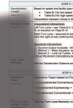
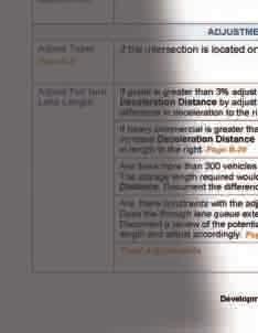
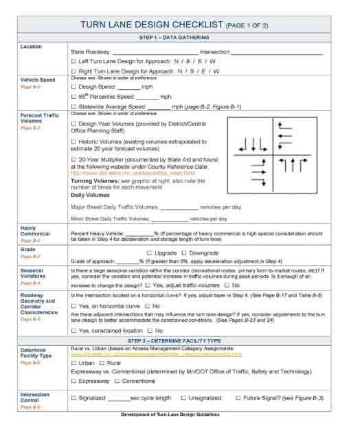
19 Checklist 17
20 Examples Part C - Examples All Mn/DOT Facilities Examples are provided for each of the eight Mn/DOT facility type situations Expressways Unsignalized Signalized Rural #1 #2 Conventional Roadways Unsignalized Signalized #3 #4 Expressways Unsignalized Signalized Urban #5 #6 Conventional Roadways Unsignalized Signalized #7 #8 Table C-1 Turn Lane Calculation Examples Roadway Location Rural Urban Roadway Expressway Type Conventional Unsignalized Type Signalized Grade Heavy Commercial Adjustments Horizontal Curve Dual Left Location Constraints Corridor Consistency Different adjustments are used in each example Example 1 x x x x x Example 2 x x x x Example 3 x x x x x Example 4 x x x x Example 5 x x x x Example 6 x x x X Example 7 x x x X X Example 8 x x x x x x 18

 82 (total adjustments) = 668 The")
 of full width turn")
 is shortened by 82 feet based on 10% reduction (90% of")
21 Example 1 Rural Expressway Unsignalized Road curves to the right, the left turn lane would be considered on the outside of the curve so an adjustment is necessary. 750 (full width from Step 4) 82 (total adjustments) = 668 The recommended design of this turn lane would be 100 feet taper and 670 feet (rounding to the nearest 10 foot) of full width turn lane. 4% upgrade, so the deceleration length determined in Step 3 (820 ) is shortened by 82 feet based on 10% reduction (90% of the length) shown in Table B-9 19

 + 17 (total adjustments) = 1,032 The recommended design of")


22 Example 2 Urban Expressway Signalized Use the Storage Length equation for the 180 second cycle length. Storage Length = (1 G/C) (DHV) (25) (2) / (cycles/hr) = (1 20/180) ( 200) (25) (2) / 20 = 445 feet 1015 (full width from Step 4) + 17 (total adjustments) = 1,032 The recommended design of this turn lane would be 180 feet taper and 1,040 feet (rounding to the nearest 10 foot) of full width turn lane. Check for blockage by queues in the through lane the through lane queue is 1,212 feet, more than the full width plus taper turn lane length. Consideration should be given to extending the left turn lane 17 feet to have the taper start at the end of the through lane queue. Queue Through = (1 G/C) (DHV) (25) (2) / (cycles/hr) = (1 50/180) (970) (25) (2) / 20 = 1,212 feet 20
23 Questions? Find full Design of Turn Lane Guidelines at: 21
Chapter Twenty-eight SIGHT DISTANCE BUREAU OF LOCAL ROADS AND STREETS MANUAL
 Chapter Twenty-eight SIGHT DISTANCE BUREAU OF LOCAL ROADS AND STREETS MANUAL Jan 2006 SIGHT DISTANCE 28(i) Chapter Twenty-eight SIGHT DISTANCE Table of Contents Section Page 28-1 STOPPING SIGHT DISTANCE
Figure 1: Vicinity Map of the Study Area
 ARIZONA TEXAS NEW MEXICO OKLAHOMA May 5, 2016 Mr. Anthony Beach, P.E. BSP Engineers 4800 Lakewood Drive, Suite 4 Waco, Texas 76710 Re: Intersection and Access Analysis along Business 190 in Copperas Cove
Traffic Impact Study. Westlake Elementary School Westlake, Ohio. TMS Engineers, Inc. June 5, 2017
 TMS Engineers, Inc. Traffic Impact Study Westlake Elementary School Westlake, Ohio June 5, 2017 Prepared for: Westlake City Schools - Board of Education 27200 Hilliard Boulevard Westlake, OH 44145 TRAFFIC
DESIGN BULLETIN #66/2010
 DESIGN BULLETIN #66/2010 Highway Geometric Design Guide Chapter B, Climbing Lane Warrants for Two Lane Undivided and Four Lane Divided Highways - Revised Summary This Design Bulletin is being issued as
Practical Application of Turn Lane Design Criteria in Developing Suburban & Urban Corridors
 Practical Application of Turn Lane Design Criteria in Developing Suburban & Urban Corridors Presented by Gilmer D. Gaston, P.E., PTOE October 14, 2014 San Antonio Austin Houston Fort Worth Dallas When
Access Location, Spacing, Turn Lanes, and Medians
 Design Manual Chapter 5 - Roadway Design 5L - Access Management 5L-3 Access Location, Spacing, Turn Lanes, and Medians This section addresses access location, spacing, turn lane and median needs, including
TABLE OF CONTENTS LIST OF FIGURES. Figure Title
 TABLE OF CONTENTS Table of Contents... 1 List of Figures... 1 Chapter Forty-two... 2 42-1.0 STOPPING SIGHT DISTANCE... 2 42-1.01 Theoretical Discussion...2 42-1.02 Passenger Car Stopping Sight Distance...
FORM A PASCO COUNTY ACCESS CONNECTION PERMIT APPLICATION
 FORM 901.3.A PASCO COUNTY ACCESS CONNECTION PERMIT APPLICATION The following information is required from all applicants directly or indirectly accessing any collector or arterial road or as otherwise
General References Definitions. (1) Design Guidance. (2) Supporting Information
 Design Guidance. (2) Supporting Information") Chapter 1240 Turning Roadways 1240.01 General 1240.02 References 1240.03 Definitions 1240.04 Turning Roadway Widths 1240.05 Documentation 1240.01 General The roadway on a curve may need to be widened to
Chapter 1240 Turning Roadways 1240.01 General 1240.02 References 1240.03 Definitions 1240.04 Turning Roadway Widths 1240.05 Documentation 1240.01 General The roadway on a curve may need to be widened to
Defining Purpose and Need
 Advanced Design Flexibility Pilot Workshop Session 4 Jack Broz, PE, HR Green May 5-6, 2010 Defining Purpose and Need In your agency s project development process, when do design engineers typically get
INDUSTRIAL BUILDING 3009 HAWTHORNE ROAD CITY OF OTTAWA TRANSPORTATION OVERVIEW REVISED. Prepared for: Canada Inc.
 INDUSTRIAL BUILDING 3009 HAWTHORNE ROAD CITY OF OTTAWA TRANSPORTATION OVERVIEW REVISED Prepared for: 7849648 Canada Inc. Octiober 1, 2015 114-598 Overview_2.doc D. J. Halpenny & Associates Ltd. Consulting
Turn Lane Warrants: Concepts, Standards, Application in Review
 Turn Lane Warrants: Concepts, Standards, Application in Review David J. DeBaie P.E., P.T.O.E. 2004 ITE, District 1 Annual Meeting Burlington, Vermont Introduction Turning lanes at intersections reduce
Issues Relating to the Geometric Design of Intersections Vergil G. Stover
 Introduction Issues Relating to the Geometric Design of Intersections Vergil G. Stover This paper presents five issues, or topics, that the author suggests be addressed in the design of intersections.
2.0 LANE WIDTHS GUIDELINE
 2.0 LANE WIDTHS GUIDELINE Road Engineering Design Guidelines Version 2.0.1 May 2018 City of Toronto, Transportation Services City of Toronto Page 0 Background In early 2014, Transportation Services initiated
Technical Memorandum. Subject: Interchange Ramp Terminal Configuration. Expiration. Implementation. Introduction
 Minnesota Department of Transportation Engineering Services Division Technical Memorandum To: Electronic Distribution Recipients From: Nancy T. Daubenberger, P.E. Assistant Commisioner, Engineering Services
Truck Climbing Lane Traffic Justification Report
 ROUTE 7 (HARRY BYRD HIGHWAY) WESTBOUND FROM WEST MARKET STREET TO ROUTE 9 (CHARLES TOWN PIKE) Truck Climbing Lane Traffic Justification Report Project No. 6007-053-133, P 101 Ι UPC No. 58599 Prepared by:
Chapter Capacity and LOS Analysis of a Signalized I/S Overview Methodology Scope Limitation
 Chapter 37 Capacity and LOS Analysis of a Signalized I/S 37.1 Overview The Highway Capacity Manual defines the capacity as the maximum howdy rate at which persons or vehicle can be reasonably expected
Figure 1: Graphical definitions of superelevation in terms for a two lane roadway.
 Iowa Department of Transportation Office of Design Superelevation 2A-2 Design Manual Chapter 2 Alignments Originally Issued: 12-31-97 Revised: 12-10-10 Superelevation is the banking of the roadway along
FINAL DESIGN TRAFFIC TECHNICAL MEMORANDUM
 FINAL DESIGN TRAFFIC TECHNICAL MEMORANDUM July 2014 FINAL (SR 43) Project Development and Environment Study From State Road 60 (Adamo Drive) to I-4 (SR 400) Hillsborough County, Florida Work Program Item
OTTAWA TRAIN YARDS PHASE 3 DEVELOPMENT CITY OF OTTAWA TRANSPORTATION IMPACT STUDY. Prepared for:
 OTTAWA TRAIN YARDS PHASE 3 DEVELOPMENT CITY OF OTTAWA TRANSPORTATION IMPACT STUDY Prepared for: The Ottawa Train Yards Inc. 223 Colonnade Road South, Suite 212 Nepean, Ontario K2E 7K3 January 17, 2012
10.0 CURB EXTENSIONS GUIDELINE
 10.0 CURB EXTENSIONS GUIDELINE Road Engineering Design Guidelines Version 1.0 March 2017 City of Toronto, Transportation Services City of Toronto Page 0 Background In early 2014, Transportation Services
REDEVELOPMENT TRAFFIC IMPACT STUDY
 REDEVELOPMENT TRAFFIC IMPACT STUDY For Wendy s Parker, Colorado January 215 Prepared for: Sterling Design Associates, LLC 29 W. Littleton Boulevard #3 Littleton, Colorado 812 Prepared by: 1233 Airport
3-13 UFC - GENERAL PROVISIONS AND GEOMETRIC DESIGN FOR ROADS, STREETS, WALKS, AND OPEN
 maintenance, and erosion. Stability is required to maintain the integrity of the pavement structure, and a slope stability analysis should be conducted for cuts and fills greater than 15 feet. For lower
2009 PE Review Course Traffic! Part 1: HCM. Shawn Leight, P.E., PTOE, PTP Crawford Bunte Brammeier Washington University
 2009 PE Review Course Traffic! Part 1: HCM Shawn Leight, P.E., PTOE, PTP Crawford Bunte Brammeier Washington University sleight@cbbtraffic.com Topic Areas Highway Capacity Manual Highway Capacity Analysis
ROUNDABOUTS/TRAFFIC CIRCLES
 GENERAL 1. Description This standard identifies minimum requirements that shall be met for Roundabouts and Neighborhood Traffic Circles in the design and construction of elements for Arlington County Horizontal
5858 N COLLEGE, LLC N College Avenue Traffic Impact Study
 5858 N COLLEGE, LLC nue Traffic Impact Study August 22, 2016 Contents Traffic Impact Study Page Preparer Qualifications... 1 Introduction... 2 Existing Roadway Conditions... 5 Existing Traffic Conditions...
Transportation Knowledge
 FE REVIEW COURSE SPRING 2017 Transportation Engineering 4/26/2017 Transportation Knowledge 8-12 problems Traffic safety Traffic capacity Traffic flow theory Traffic control devices Transportation planning
CROSSING GUARD PLACEMENT CONSIDERATIONS AND GAP ASSESSMENT
 CROSSING GUARD PLACEMENT CONSIDERATIONS AND GAP ASSESSMENT Many factors contribute to the need for a Crossing Guard. General federal guidance, provided by the FHWA MUTCD, states that adult crossing guards
Traffic Impact Analysis Chatham County Grocery Chatham County, NC
 Chatham County Grocery Chatham County, NC TABLE OF CONTENTS 1. INTRODUCTION... 1 1.1. Location and Study Area... 1 1.2. Proposed Land Use and Access... 2 1.3. Adjacent Land Uses... 2 1.4. Existing ways...
I-95 Northbound at US 1 (Exit 126) Design and Study Final Report
 Design and Study Final Report") I-95 Northbound at US 1 (Exit 126) Design and Study Final Report July 2018 Prepared by: Prepared for: TABLE OF CONTENTS 1 Introduction... 1 Study Area Limits... 1 Purpose and Need of the Study... 1 Safety
I-95 Northbound at US 1 (Exit 126) Design and Study Final Report July 2018 Prepared by: Prepared for: TABLE OF CONTENTS 1 Introduction... 1 Study Area Limits... 1 Purpose and Need of the Study... 1 Safety
Alberta Highway 881. Corridor Management Plan. Session Forum 1 - Highways. Tri-Party Transportation Conference Moving Alberta Into the Future
 Tri-Party Transportation Conference Moving Alberta Into the Future Alberta Highway 881 Corridor Management Plan Lac La Biche to Anzac Session Forum 1 - Highways March 2017 INTRODUCTION + 241 km long, 2
TRAFFIC ASSESSMENT River Edge Colorado
 TRAFFIC ASSESSMENT River Edge Colorado Submitted by: Fehr & Peers 621 17th Street, Ste. 231 Denver, CO 8293 (33) 296-43 December, 21 App. M-2 Traffic Assessment River Edge Colorado December 21 TABLE OF
Traffic Academy: IJS & IMS FAQ/RULES OF THUMB
 FAQ/RULES OF THUMB HCS intersection analysis criteria See LDM Figure 401-14aE Cycle lengths between 60 to 120 seconds No impractical phases, i.e., 1 second green time Yellow + All Red must be no less than
TRAFFIC STUDY GUIDELINES Clarksville Street Department
 TRAFFIC STUDY GUIDELINES Clarksville Street Department 9/1/2009 Introduction Traffic studies are used to help the city determine potential impacts to the operation of the surrounding roadway network. Two
TRANSPORTATION ANALYSIS REPORT US Route 6 Huron, Erie County, Ohio
 TRANSPORTATION ANALYSIS REPORT US Route 6 Huron, Erie County, Ohio December 12, 2012 Prepared for: The City of Huron 417 Main Huron, OH 44839 Providing Practical Experience Technical Excellence and Client
Traffic Impact Study WestBranch Residential Development Davidson, NC March 2016
 Traffic Impact Study WestBranch Residential Development Davidson, NC March 216 TRAFFIC IMPACT STUDY FOR THE WestBranch Residential Development LOCATED IN DAVIDSON, NC Prepared For: Lennar Carolinas, LLC
Subject: Use of Pull-off Areas in Work Zones Page: 1 of 13. Brief Description: Guidance for the use and placement of pull-off area in work zones.
 6 - G2 Subject: Use of Pull-off Areas in Work Zones Page: 1 of 13 MdMUTCD REF. NO. None Date Issued: 09/09 Effective Date: 09/09 Brief Description: Guidance for the use and placement of pull-off area in
OFFICE/RETAIL DEVELOPMENT 1625 BANK STREET OTTAWA, ONTARIO TRANSPORTATION BRIEF. Prepared for: Canada Inc.
 OFFICE/RETAIL DEVELOPMENT 1625 BANK STREET OTTAWA, ONTARIO TRANSPORTATION BRIEF Prepared for: 9402209 Canada Inc. December 15, 2015 115-625 Report_2.doc D. J. Halpenny & Associates Ltd. Consulting Transportation
Traffic Engineering and Highway Safety Bulletin June Overview
 Traffic Engineering and Highway Safety Bulletin 18-03 June 2018 INTERSECTION GEOMETRIC DESIGN In This Issue Overview... 1 Intersection Types... 2 Traffic Control Selection... 3 Capacity Analysis... 6 Design
Traffic Impact Analysis (TIA) Process and Procedures Manual. September 2017
 Process and Procedures Manual. September 2017") Traffic Impact Analysis (TIA) Process and Procedures Manual Post Office Box 664 101 Huntersville-Concord Road Huntersville, NC 28070 Phone 704-766-2220 Fax 704-992-5528 www.huntersville.org (c) 2017, Town
Traffic Impact Analysis (TIA) Process and Procedures Manual Post Office Box 664 101 Huntersville-Concord Road Huntersville, NC 28070 Phone 704-766-2220 Fax 704-992-5528 www.huntersville.org (c) 2017, Town
This Technical Memorandum extends the expiration date of Technical Memorandum TS-07 to August 1, 2021 unless superseded prior to that date.
 Minnesota Department of Transportation Engineering Services Division Technical Memorandum No. 18-08-TS-06 August 1, 2018 Technical Memorandum To: Electronic Distribution Recipients From: Nancy T. Daubenberger,
Shawn Leight, P.E., PTOE, PTP CBB Transportation Engineers + Planners ITE International President Washington University
 JCE 3460 Traffic! Shawn Leight, P.E., PTOE, PTP CBB Transportation Engineers + Planners ITE International President Washington University sleight@cbbtraffic.com Primary Traffic References AASHTO Green
Technical Memorandum TRAFFIC IMPACT STUDY. RIDLEY ROAD CONVENIENCE STORE Southampton County, VA. Prepared for: Mr. David Williams.
 Technical Memorandum TRFFIC IMPCT STUDY RIDLEY ROD CONVENIENCE STORE Southampton County, V Prepared for: Mr. David Williams By: Charles Smith, P.E., PTOE EPR Charlottesville, V July 2014 1 TBLE OF CONTENTS
Intersection Traffic Control Feasibility Study
 Intersection Traffic Control Feasibility Study CSAH 9 at CSAH 60 (185th Avenue) Prepared For: Dakota County Transportation Department Western Service Center 14955 Galaxie Avenue, 3rd Floor Apple Valley,
Highway 111 Corridor Study
 Highway 111 Corridor Study June, 2009 LINCOLN CO. HWY 111 CORRIDOR STUDY Draft Study Tea, South Dakota Prepared for City of Tea Sioux Falls Metropolitan Planning Organization Prepared by HDR Engineering,
Roadway Design Manual
 Roadway Design Manual Manual Notice Archive by Texas Department of Transportation (512) 302-2453 all rights reserved Manual Notice 2009-1 From: Manual: Mark A. Marek, P.E Roadway Design Manual Effective
Glenn Avenue Corridor Traffic Operational Evaluation
 Glenn Avenue Corridor Traffic Operational Evaluation PREPARED FOR: THE CITY OF AUBURN PREPARED BY: DECEMBER 2007 Glenn Avenue Corridor Study--Auburn, Alabama TABLE OF CONTENTS Introduction... 1 Background
Topic No January 2000 Manual on Uniform Traffic Studies Revised July Chapter 8 GAP STUDY
 Chapter 8 8.1 PURPOSE GAP STUDY (1) The Gap Study is used to determine the size and the number of gaps in the vehicular traffic stream for unsignalized intersections and access points, pedestrian studies,
BASIC FREEWAY CAPACITY STUDIES Definitions
 Definitions A freeway is a divided highway facility having two or more lanes in each direction for the exclusive use of traffic with full control of access and egress. Freeway is the only facility that
1.3.4 CHARACTERISTICS OF CLASSIFICATIONS
 Geometric Design Guide for Canadian Roads 1.3.4 CHARACTERISTICS OF CLASSIFICATIONS The principal characteristics of each of the six groups of road classifications are described by the following figure
Subject: Solberg Avenue / I-229 Grade Separation: Traffic Analysis
 MEMORANDUM Transportation Bill Troe, AICP Jason Carbee, AICP 12120 Shamrock Plaza Suite 300 Omaha, NE 68154 (402) 334-8181 (402) 334-1984 (Fax) To: Project File Date: Subject: Solberg Avenue / I-229 Grade
ENHANCED PARKWAY STUDY: PHASE 2 CONTINUOUS FLOW INTERSECTIONS. Final Report
 Preparedby: ENHANCED PARKWAY STUDY: PHASE 2 CONTINUOUS FLOW INTERSECTIONS Final Report Prepared for Maricopa County Department of Transportation Prepared by TABLE OF CONTENTS Page EXECUTIVE SUMMARY ES-1
HILTON GARDEN INN HOTEL HOTEL EXPANSION 2400 ALERT ROAD, OTTAWA TRANSPORTATION BRIEF. Prepared for:
 HILTON GARDEN INN HOTEL HOTEL EXPANSION 2400 ALERT ROAD, OTTAWA TRANSPORTATION BRIEF Prepared for: Bona Building & Management Co. Ltd. Place Vanier, 333 North River Road Vanier, Ontario K1L 8B9 October
THE FUTURE OF THE TxDOT ROADWAY DESIGN MANUAL
 THE FUTURE OF THE TXDOT ROADWAY DESIGN MANUAL Kenneth Mora, P.E. (Design Division) 10/10/2017 Table of contents 1 2 Reduction in FHWA design controlling criteria Innovative Intersection Guidance 3-7 8-42
FEBRUARY, 2001 ROAD DESIGN MANUAL (ENGLISH) 6-0(1)
 6-0(1)") FEBRUARY, 2001 ROAD DESIGN MANUAL (ENGLISH) 6-0(1) CHAPTER 6 INTERCHANGES AND GRADE SEPARATIONS 6-1.0 GENERAL 6-1.01 Definitions 6-1.02 Warrants 6-1.03 Types of Interchanges 6-1.03.01 General 6-1.03.02
FEBRUARY, 2001 ROAD DESIGN MANUAL (ENGLISH) 6-0(1) CHAPTER 6 INTERCHANGES AND GRADE SEPARATIONS 6-1.0 GENERAL 6-1.01 Definitions 6-1.02 Warrants 6-1.03 Types of Interchanges 6-1.03.01 General 6-1.03.02
T R A N S P O R T A T I O N M E M O R A N D U M
 WILKINSON LLC t raffic engineering and t ransportation p lanning 3405 Harbor Way Fort Collins, CO 80524 phone: 970-988-0143 fax: 970-472-0223 martinawilkinson@msn.com T R A N S P O R T A T I O N M E M
Traffic Signal Warrant Analysis Report
 Traffic Signal Warrant Analysis Report US26: Springwater At-Grade Intersection key# 15773 US26 at SE 267 th Avenue (M.P. 16.24) and US26 at SE Stone Road (M.P. 16.77) Prepared by Katherine Carlos, E.I.
A Traffic Operations Method for Assessing Automobile and Bicycle Shared Roadways
 A Traffic Operations Method for Assessing Automobile and Bicycle Shared Roadways A Thesis Proposal By James A. Robertson Submitted to the Office of Graduate Studies Texas A&M University in partial fulfillment
INDUSTRIAL BUILDING 1660 COMSTOCK ROAD CITY OF OTTAWA TRANSPORTATION OVERVIEW. Prepared for:
 INDUSTRIAL BUILDING 1660 COMSTOCK ROAD CITY OF OTTAWA TRANSPORTATION OVERVIEW Prepared for: Simluc Contractors Limited 2550 Blackwell Street, Ottawa K1B 5R1 October 18, 2013 113-584 Overview_1.doc D. J.
MEDICAL/OFFICE BUILDING 1637 BANK STREET OTTAWA, ONTARIO TRANSPORTATION OVERVIEW. Prepared for:
 MEDICAL/OFFICE BUILDING 1637 BANK STREET OTTAWA, ONTARIO TRANSPORTATION OVERVIEW Prepared for: 2434984 Ontario Inc. 13-5510 Canotek Road Ottawa, Ontario K1J 9J5 June 4, 2015 115-613 Report_2.doc D. J.
Chapter 4 Traffic Analysis
 Chapter 4 Traffic Analysis PURPOSE The traffic analysis component of the K-68 Corridor Management Plan incorporates information on the existing transportation network, such as traffic volumes and intersection
400 Intersection Design
 400 Intersection Design Table of Contents 401 Intersections At-Grade... 4-1 401.1 Intersection Locations... 4-1 401.2 Intersection Traffic Control and Operational Analysis... 4-1 401.2.1 Signals.4-1 401.2.2
Chapter 5 5. INTERSECTIONS 5.1. INTRODUCTION
 Chapter 5 5. INTERSECTIONS 5.1. INTRODUCTION Intersections are the physical component of the roadways where two highways intersect. They are the most complex element of roadways, since it requires more
TRAFFIC SIGNAL WARRANT STUDY
 TRAFFIC SIGNAL WARRANT STUDY 5 th STREET & ENCHANTED PINES DRIVE JANUARY 2013 TRAFFIC OPERATIONS ENGINEERING SERVICES/PUBLIC WORKS DEPARTMENT TABLE OF CONTENTS INTERSECTION LOCATION MAP ii INTRODUCTION
CIRCLE DRIVE TRAFFIC AND ACCESS MANAGEMENT POLICY GUIDE. Management Principles and Implementation Concepts
 CIRCLE DRIVE TRAFFIC AND ACCESS MANAGEMENT POLICY GUIDE A. PREFACE Management Principles and Implementation Concepts The intent of this policy guide is to provide interim guidance on the implementation
Arterial Traffic Analysis Actuated Signal Control
 Arterial Traffic Analysis Actuated Signal Control Dr. Gang-Len Chang Professor and Director of Traffic Safety and Operations Lab. University of Maryland-College Park Actuated Signal Control Fully Actuated
Traffic Impact Study Little Egypt Road Development Denver, North Carolina June 2017
 Traffic Impact Study Little Egypt Road Development Denver, North arolina June 2017 N. Little Egypt Road DQ\ QDQFLQJ VDOHV RU RWKHU SHUIRUPDQFH EDVHG FULWHULD Proposed Site Driveways Site Driveway 1 TRAFFI
Operational Comparison of Transit Signal Priority Strategies
 Operational Comparison of Transit Signal Priority Strategies Revision Submitted on: November, 0 Author: Adriana Rodriguez, E.I Assistant Engineer Parsons Brinckerhoff 0 South Orange Avenue, Suite 00 Orlando,
Best Practices for the Design and Operation of Reduced Conflict Intersections
 Best Practices for the Design and Operation of Reduced Conflict Intersections OCTOBER 2016 Prepared By: Table of Contents INTRODUCTION... 5 Purpose... 5 Definition... 5 Advantages... 6 Disadvantages...
PINESTONE TRAFFIC IMPACT STUDY Travelers Rest, South Carolina
 PINESTONE TRAFFIC IMPACT STUDY Travelers Rest, South Carolina Prepared for Longbranch Development Prepared by January 13, 219 ii Table of Contents Subject Page Signature Page... i Table of Contents...
Traffic Impact Analysis Walton Acres at Riverwood Athletic Club Clayton, NC
 Traffic Impact Analysis Walton Acres at Riverwood Athletic Club Clayton, NC 1. TABLE OF CONTENTS INTRODUCTION...1 1.1. Site Location and Study Area...1 1.2. Proposed Land Use and Site Access...2 1.3.
Harrah s Station Square Casino
 Transportation Analysis Harrah s Station Square Casino Pittsburgh, Pennsylvania Submitted To: City of Pittsburgh and Pennsylvania Gaming Control Board Prepared By: DKS Associates GAI Consultants December
ATTACHMENT NO. 18 GMI-C. National Committee on Uniform Traffic Control Devices GMI SIGNS TECHNICAL COMMITTEE RECOMMENDATION
 1 2 3 ATTACHMENT NO. 18 GMI-C 4 5 6 7 8 9 10 11 12 13 14 15 16 17 18 19 20 21 22 23 24 25 26 27 28 29 30 31 32 33 34 35 36 37 38 39 GMI agenda item II.H.2., January 19, 2012 National Committee on Uniform
Walmart (Store # ) 60 th Street North and Marion Road Sioux Falls, South Dakota
 60 th Street North and Marion Road Sioux Falls, South Dakota") Walmart (Store #4865-00) 60 th Street North and Marion Road Sioux Falls, South Dakota Prepared for: Wal-Mart Stores, Inc. Bentonville, Arkansas Prepared by: Kimley-Horn and Associates, Inc. ã2013 Kimley-Horn
Walmart (Store #4865-00) 60 th Street North and Marion Road Sioux Falls, South Dakota Prepared for: Wal-Mart Stores, Inc. Bentonville, Arkansas Prepared by: Kimley-Horn and Associates, Inc. ã2013 Kimley-Horn
MUTCD Part 6G: Type of Temporary Traffic Control Zone Activities
 MUTCD Part 6G: Type of Temporary Traffic Control Zone Activities 6G.01 Typical Applications Each temporary traffic control (TTC) zone is different. Many variables, such as location of work, highway type,
CITY OF SASKATOON COUNCIL POLICY
 ORIGIN/AUTHORITY Clause 1, Report No. 1-1980 and Clause 4, Report No. 22-1990 of the Works and Utilities Committee; Clause 6, Report No. 17-2004 of the Planning and Operations Committee; and Clause D5,
Washington St. Corridor Study
 FIGURE 7.17 Bridge Alternatives - Cross Sections 86 Discarded Alternative: Short-Term Bridge Repair Short-term repairs and west bridge span replacement were considered during analysis. Short-term repairs
MEETING FACILITY 2901 GIBFORD DRIVE CITY OF OTTAWA TRANSPORTATION BRIEF. Prepared for: Holiday Inn Express 2881 Gibford Drive Ottawa, ON K1V 2L9
 MEETING FACILITY 2901 GIBFORD DRIVE CITY OF OTTAWA TRANSPORTATION BRIEF Prepared for: Holiday Inn Express 2881 Gibford Drive Ottawa, ON K1V 2L9 December 18, 2012 112-566 Brief_1.doc D. J. Halpenny & Associates
City of Wayzata Comprehensive Plan 2030 Transportation Chapter: Appendix A
 A1. Functional Classification Table A-1 illustrates the Metropolitan Council s detailed criteria established for the functional classification of roadways within the Twin Cities Metropolitan Area. Table
QUICKIE C STORE AND GAS BAR 1780 HERON ROAD OTTAWA, ONTARIO TRANSPORTATION BRIEF. Prepared for:
 QUICKIE C STORE AND GAS BAR 1780 HERON ROAD OTTAWA, ONTARIO TRANSPORTATION BRIEF Prepared for: Quickie Convenience Stores Larny Holdings Ltd. c/o PBC Group April 15, 2015 115-615 Report_1.doc D. J. Halpenny
CHAPTER 1 STANDARD PRACTICES
 CHAPTER 1 STANDARD PRACTICES OBJECTIVES 1) Functions and Limitations 2) Standardization of Application 3) Materials 4) Colors 5) Widths and Patterns of Longitudinal Pavement Marking Lines 6) General Principles
KDOT Access Management Policy (AMP)
") KDOT Access Management Policy (AMP) (January 2013 Edition) Errata KDOT intends to correct these errors during the next revision to the Policy. Corrections are denoted in red text with a solid line through
KDOT Access Management Policy (AMP) (January 2013 Edition) Errata KDOT intends to correct these errors during the next revision to the Policy. Corrections are denoted in red text with a solid line through
DUNBOW ROAD FUNCTIONAL PLANNING
 DUNBOW ROAD FUNCTIONAL PLANNING Final Report August 3, 216 #31, 316 5th Avenue NE Calgary, AB T2A 6K4 Phone: 43.273.91 Fax: 43.273.344 wattconsultinggroup.com Dunbow Road Functional Planning Final Report
EFFICIENCY OF TRIPLE LEFT-TURN LANES AT SIGNALIZED INTERSECTIONS
 EFFICIENCY OF TRIPLE LEFT-TURN LANES AT SIGNALIZED INTERSECTIONS Khaled Shaaban, Ph.D., P.E., PTOE (a) (a) Assistant Professor, Department of Civil Engineering, Qatar University (a) kshaaban@qu.edu.qa
Highway Capacity and LOS. Reading Assignment: pgs
 Highway Capacity and LOS Reading Assignment: pgs. 170-200 We know from the previous section that traffic flows fairly well when Demand < Capacity. However, when demand approaches capacity, we begin to
Safety Impacts: Presentation Overview
 Safety Impacts: Presentation Overview The #1 Theme How Access Management Improves Safety Conflict Points The Science of Access Management By Treatment Studies Themes for Texas Access Management Improve
List of Attachments. Location Map... Site Plan... City of Lake Elsinore Circulation Element... City of Lake Elsinore Roadway Cross-Sections...
 List of Attachments Exhibits Location Map... Site Plan... City of Lake Elsinore Circulation Element... City of Lake Elsinore Roadway Cross-Sections... Existing Lane Geometry and Traffic Controls... Existing
CHAPTER 3A. GENERAL PAGE CHAPTER 3B. PAVEMENT AND CURB MARKINGS PAGE
 Virginia Supplement to the 2009 MUTCD Revision 1 Page TC-3-1 PART 3. MARKINGS CHAPTER 3A. GENERAL PAGE Section 3A.01 Functions and Limitations Section 3A.02 Standardization of Application Section 3A.03
Attachment No. 17 GMI No. 1. National Committee on Uniform Traffic Control Devices GMI SIGNS TECHNICAL COMMITTEE RECOMMENDATION
 1 2 3 Attachment No. 17 GMI No. 1 4 5 6 7 8 9 10 11 12 13 14 15 16 17 18 19 20 21 22 23 24 25 26 27 28 29 30 31 32 33 34 35 36 37 GMI agenda item II.H.2., January 19, 2012 National Committee on Uniform
Roundabout Design Aid PREPARED BY TRAFFIC AND SAFETY
 Roundabout Design Aid PREPARED BY TRAFFIC AND SAFETY May 2018 Engineering Manual Preamble This manual provides guidance to administrative, engineering, and technical staff. Engineering practice requires
Basic Freeways and Multilane Highways (LOS) CIVL 4162/6162
 CIVL 4162/6162") Basic Freeways and Multilane Highways (LOS) CIVL 4162/6162 Learning Objectives Define uninterrupted facilities Determine LOS of Basic freeway segments Multilane highways Uninterrupted Flow Facilities Pure
Basic Freeways and Multilane Highways (LOS) CIVL 4162/6162 Learning Objectives Define uninterrupted facilities Determine LOS of Basic freeway segments Multilane highways Uninterrupted Flow Facilities Pure
Off-road Trails. Guidance
 Off-road Trails Off-road trails are shared use paths located on an independent alignment that provide two-way travel for people walking, bicycling, and other non-motorized users. Trails specifically along
400 Intersection Design
 400 Intersection Design Table of Contents 401 Intersections At-Grade... 4-1 401.1 Intersection Locations... 4-1 401.2 Intersection Traffic Control and Operational Analysis... 4-1 401.2.1 Signals. 4-1 401.2.2
Focus of activity - The land near intersections often contains a concentration of travel destinations.
 Chapter 6 Intersection Design 6.1 Introduction An intersection is the area where two or more streets join or cross at-grade. The intersection includes the areas needed for all modes of travel: pedestrian,
MEMORANDUM TERESA MCCLISH, COMMUNITY DEVELOPMENT DIRECTOR SUBJECT: CONSIDERATION OF RESTRICTING PARKING ADJACENT TO 170 AND 171 BRISCO ROAD
 MEMORANDUM TO: FROM: BY: TRAFFIC COMMISSION TERESA MCCLISH, COMMUNITY DEVELOPMENT DIRECTOR MATT HORN, CITY ENGINEER SUBJECT: CONSIDERATION OF RESTRICTING PARKING ADJACENT TO 170 AND 171 BRISCO ROAD DATE:
TRAFFIC AND SAFETY NOTE 608A. Spacing for Commercial Drives and Streets. To Promote a Uniform Practice in Determining Access Spacing
 TRAFFIC AND SAFETY NOTE 608A SUBJECT: PURPOSE: Spacing for Commercial Drives and Streets To Promote a Uniform Practice in Determining Access Spacing COORDINATING UNIT: Geometric Design Unit INFORMATION:
1609 E. FRANKLIN STREET HOTEL TRAFFIC IMPACT STUDY EXECUTIVE SUMMARY
 1609 E. FRANKLIN STREET HOTEL TRAFFIC IMPACT STUDY EXECUTIVE SUMMARY Prepared for: The Town of Chapel Hill Public Works Department Traffic Engineering Division Prepared by: HNTB North Carolina, PC 343
THIS PAGE LEFT BLANK INTENTIONALLY
 GA SR 25 Spur at Canal Road Transportation Impact Analysis PREPARED FOR GLYNN COUNTY, GEORGIA 1725 Reynolds Street, Suite 300 Brunswick, Georgia 31520 PREPARED BY 217 Arrowhead Boulevard Suite 26 Jonesboro,
Volume-to-Capacity Estimation of Signalized Road Networks for Metropolitan Transportation Planning
 Volume-to-Capacity Estimation of Signalized Road Networks for Metropolitan Transportation Planning Hao Xu (Corresponding Author) Research Associate Department of Civil & Environmental Engineering Texas
Roundabouts along Rural Arterials in South Africa
 Krogscheepers & Watters 0 0 Word count: 00 text + figures = 0 equivalent words including Title and Abstract. Roundabouts along Rural Arterials in South Africa Prepared for: rd Annual Meeting of Transportation