Chapter 7 Nonmotorized Facilities
|
|
|
- Lesley Hood
- 6 years ago
- Views:
Transcription
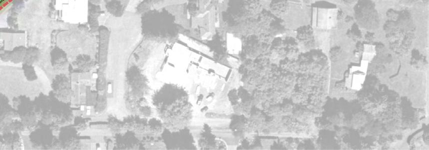
1 Chapter 7 Nonmotorized Facilities What is in this chapter? This chapter discusses existing and proposed pedestrian and bicycle facilities referred to as nonmotorized facilities along the SR 520 corridor. Because the Medina to SR 202: Eastside Transit and HOV Project provides opportunities to connect pedestrian, bicycle, and transit systems throughout the region, the chapter also discusses how the project would fit into regional nonmotorized planning efforts, as well as how nonmotorized facilities interact with existing and proposed transit facilities. The SR 520 Bridge Replacement and HOV Program Draft Environmental Impact Statement (Draft EIS), published in August 2006, included an evaluation of nonmotorized facilities and description of proposed improvements. As part of this evaluation, transportation analysts conducted the following activities: Reviewed existing conditions Solicited public input through participation in community design workshops and open houses Coordinated with local bicycle/pedestrian organizations and nonmotorized transportation plans, including Puget Sound Regional Council, Seattle Department of Transportation, Seattle Bicycle Advisory Board, Seattle Pedestrian Advisory Board, Redmond Parks Department, Redmond Public Works Department, University of Washington, King County Department of Natural Resources and Parks, Bellevue Transportation Department, and the Bike Alliance Developed requirements and design standards for a shared-use path system Since publication of the Draft EIS, the project team has continued its community coordination efforts to keep the project consistent with city and town infrastructure planning and construction. During 2007 and 2008, the project team conducted workshops with the mayors of Medina, Hunts Point, Clyde Hill, Yarrow Point, Kirkland, and Bellevue EA_DR_TRAN_CH07_NONMOTORIZED.DOC 7-1
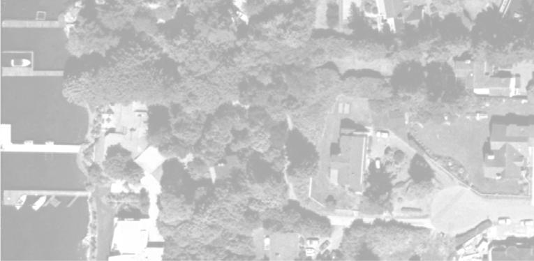
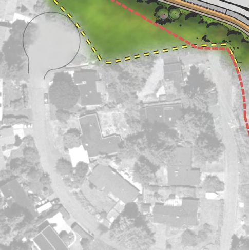
2 and their technical staff to provide opportunities to define the Eastside highway section of the project from the edge of Lake Washington to South Bellevue Way. Design guidelines for nonmotorized facilities were also evaluated. This chapter identifies the proposed changes to nonmotorized design since the 2006 Draft EIS. What is the nonmotorized experience like today? Although there are existing Class I, II, and III bicycle trails (see side box) along the SR 520 corridor in the project vicinity, there are gaps in the combined system of exclusive off-street and shared on-street facilities that do not encourage long-distance nonmotorized travel. Currently, there is no continuous Class I trail within the project limits to serve commuters or recreational users. Because there is no pedestrian or bicycle access across the Evergreen Point Bridge to connect nonmotorized traffic on the Eastside to Seattle, cyclists must mount their bicycles on buses (which have limited bike-rack capacity) to cross the bridge. The Points Loop Trail is one of the longest nonmotorized trails in the project vicinity today. The trail is paved with asphalt and varies from 8 to 10 feet wide; it extends from Evergreen Point Road to 96th Avenue NE, parallel and along the north side of SR 520 through the project site. The trail also loops south through Medina, Hunts Point, and Yarrow Point. It has both on-street and offstreet portions, including an on-street segment between 92nd Avenue NE and 96th Avenue NE. Along SR 520, the trail is separated from the highway and adjacent properties by a chain link fence, although the trail also winds through a vegetative buffer in places that contributes to the trail experience. The trail has grades that exceed 5 percent in several areas and is not compliant with the American with Disabilities Act (ADA). It is designed to follow the area s rolling topography, not as a direct transportation facility, reducing its effectiveness as a route for bicycle commuter traffic. Bicyclists and pedestrians can access existing bus stops from the trail and transfer bicycles to buses for transport along SR 520 if needed and if bike space is available on the desired bus. Along its route, the Points Loop Trail can be accessed from 84th and 92nd Avenues NE, where it crosses those roads at-grade. A footbridge Class I bicycle facilities are paved and have exclusive rights-of-way for the principal use of bicycles, pedestrians, and other nonmotorized means of travel and they are required to be at least 10 feet wide. Class II bicycle facilities are established within the paved area of arterials for the preferential use of bicycles. These paved bicycle areas, or bike lanes, are striped in widths varying between 4 and 12 feet and are signed as designated bikeways. Class III bicycle facilities are located along existing arterials (without striping) and are intended to provide continuity within the bikeway system. EA_DR_TRAN_CH07_NONMOTORIZED.DOC 7-2
3 provides a local north-south neighborhood bicycle and pedestrian connection to the Points Loop Trail. The footbridge spans SR 520 from Bellevue Christian School/Three Points Elementary School to the Fairweather Nature Preserve just east of Evergreen Point Road. The footbridge is not ADA compliant and is not accessible to wheelchairs. NE Points Drive serves as a bicycle connection between Lake Washington Boulevard NE/Bellevue Way NE and the Points Loop Trail. The Points Loop Trail begins at the Yarrow Point city limit where NE Points Drive is closed to vehicular through-traffic by a brick and bollard barrier. There are no dedicated Class I, II, or III bicycle facilities between South Bellevue Way and 108th Avenue NE. From north to south, a Class II /III bicycle route begins on 108th Avenue NE, just south of its intersection with SR 520. Within the project site, pedestrians can use sidewalks or shoulders along all of the major roadways in the interchange areas (i.e., Evergreen Point Road, 84th Avenue NE, 92nd Avenue NE, South Bellevue Way, and 108th Avenue NE). At Evergreen Point Road, a narrow pedestrian path is located along the east side of the roadway through the project site, and there are narrow raised walkways on each side of the street across the SR 520 overpass. There are no marked or signalized crosswalks on the project site. At 84th Avenue NE, there are raised, narrow walkways on both sides of the street across the SR 520 overpass. At the intersection of 84th Avenue NE and NE 28th Street, just south of SR 520, there are marked and unsignalized crosswalks across all legs of the intersection. At 92nd Avenue NE, there is a sidewalk on the west side of the street across the SR 520 overpass. There is a shoulder along the roadway north and south of the bridge and a raised walkway on the east side of the overpass. South of SR 520, at the intersection of NE 32nd Street, 92nd Avenue NE, and Points Drive NE, there is a sidewalk along the west side of 92nd Avenue NE. Crosswalks are marked on the west side of 92nd Avenue NE through this multi-leg intersection. At South Bellevue Way, there is a sidewalk on the west side of the interchange area and across the SR 520 overpass. There is no crosswalk or pedestrian signal on South Bellevue Way to cross the EA_DR_TRAN_CH07_NONMOTORIZED.DOC 7-3
4 westbound SR 520 on-ramp. There are no pedestrian or bicycle facilities on the east side of the road through the interchange. Pedestrians and bicycles generally have a difficult time moving through the South Bellevue Way interchange area. There is a crossing signal north of the interchange at the Northup Way intersection with South Bellevue Way. At 108th Avenue NE there is a sidewalk along the west side of the roadway through the interchange area but not on the east side. In the interchange area itself, there is no crosswalk or pedestrian signal on the west side of 108th Avenue NE at the intersection with the westbound SR 520 on-ramp. Pedestrians can cross over 108th Avenue NE in this area by moving west to east across 108th using a crosswalk at the southwest corner of the interchange, then using a crosswalk and pedestrian signal in place at the off-ramp intersection on the east side of the road to cross the SR 520 westbound off-ramp. North of SR 520, there are sidewalks on both sides of 108th Avenue NE, and there are crosswalks and pedestrian signals at the intersection of 108th Avenue NE with Northup Way. There are currently two sets of freeway transit stations along the outside shoulders of SR 520 along the project corridor: the eastbound and westbound Evergreen Point freeway stations and the 92nd Avenue NE Freeway Transit Station. Cyclists waiting to board buses at these locations sometimes have relatively long waits if they need to access specific bus routes across the lake and the bike racks on those buses are full. Nonmotorized traffic on the Points Loop Trail has direct access to the westbound Evergreen Point Freeway Transit Station near Evergreen Point Road. However, to reach the eastbound transit stop near Evergreen Point Road, nonmotorized traffic from the trail crosses over SR 520 on Evergreen Point Road or uses a non-ada-accessible footbridge, located approximately at 78th Avenue NE, to cross to the east side of the freeway, then enters the park-and-ride lot and uses a paved path to reach the transit stop at the freeway. A stairway at the northwest corner of the 92nd Avenue NE overpass provides access to the westbound freeway transit stop at this location. Pedestrians must walk down this stairway and along the SR 520 shoulder behind a jersey barrier to reach the transit stop. There is no wheelchair access at the westbound stop. The eastbound transit stop is EA_DR_TRAN_CH07_NONMOTORIZED.DOC 7-4
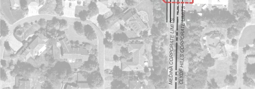
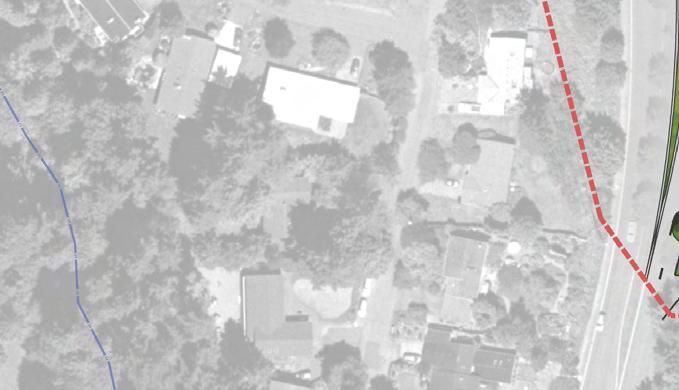
5 accessed using a paved path from 92nd Avenue NE between the freeway on ramp and the freeway. Exhibit 7-1 shows the location of existing Class I nonmotorized features both in and outside of the project site. The exhibit also shows the nonmotorized features, other than sidewalks, that would be built with the project, as well as one trail proposed by others the Burlington Northern Santa Fe Railroad right-of-way/trail that would extend south from north Kirkland to through Bellevue. There is a substantial network of interconnected trails in the region, which the project would supplement. The Burke-Gilman, Sammamish River, SR 520, and I-90 trails are four facilities that provide critical regional linkages. The Burke-Gilman and Sammamish River trails are connected and function as one 27-mile-long trail, extending from the Fremont neighborhood in Seattle, around the north end of Lake Washington to Marymoor Park in Redmond. The trail is paved and is part of the Locks to Lakes Corridor. It is used by commuters and recreational traffic. The SR 520 trail is a multiuse, asphalt-paved pathway. It is 10 feet wide, grade-separated, and runs along the north side of SR 520 from the vicinity of the NE 20th Street/124th Avenue NE intersection in Bellevue to the SR 520/West Lake Sammamish Parkway interchange in Redmond. The I-90 trail extends from Seattle to south Bellevue along I-90. It connects to the North Lake Washington Loop Trail, which is a 42-milelong facility around the northern end of the lake, with both Class II and Class I segments. The I-90 trail also connects to the South Lake Washington Loop, which is 48 miles of Class I and Class II trails around the south end of Lake Washington. All of these trails connect to other regional and local facilities. For more detailed information on existing and planned trails in the region, refer to the King County Bicycling Guide Map (King County Department of Transportation 2009), City of Bellevue s Pedestrian and Bicycle Transportation Plan (City of Bellevue 2007), and City of Kirkland s Active Transportation Plan (City of Kirkland 2009). EA_DR_TRAN_CH07_NONMOTORIZED.DOC 7-5
6 Sammamish River Trail NE 80TH ST UV 908 NE REDMOND WAY NE UNION HILL RD North Lake Washington Trail LAKE WASHINGTON BLVD NE NE 70TH ST 140TH AVE NE UV 202 UV 520 BNSF Right-of-Way K I R K L A N D Lake Washington WEST LAKE SAMMAMISH PKWY NE TH AVE NE 132ND AVE NE R E D M O N D Freeway Transit Stop at Evergreen Pt. Rd. Points Loop Trail AREA OF DETAIL Reconstructed Portion of Points Loop Trail EVERGREEN POINT RD!( ")!( M E D I N A!( Existing Footbridge H U N T S P O I N T Footbridge Over SR 520 (to be removed) C L Y D E H I L L Y A R R O W P O I N T!( ") 92ND AVE NE Existing Trail Freeway Transit Stop at 92nd Ave NE Points Loop Trail Extension Existing Local Street Connection Bellevue Way Shared Use Bike Path 108th Ave NE Bicycle Lane BELLEVUE WAY NE SR 520 Regional Bicycle Path NORTHUP WAY Northup Way Bicycle Pedestrian Facility 112TH AVE NE 116TH AVE NE Bike lane on Northup Way planned by others (City of Bellevue 2009) 124TH AVE NE B E L L E V U E NE 40TH ST NE 24TH ST NE 20TH ST 140TH AVE NE SR 520 Bikeway 148TH AVE NE UV TH AVE NE NE BELLEVUE REDMOND RD WEST LAKE S AMMAMISH PKWY NE Source: King County (2008) GIS Data (Existing Trails, Streams, Streets, Water Bodies), Seattle Bike Touring Club (2005) GIS Data (Existing Trails), City of Kirkland (2008) GIS Data (Trail Proposed by Others), CH2M HILL (2008) GIS Data (Parks). Horizontal datum for all layers is NAD83(91), vertical datum for layers is NAVD88. Note: Existing and proposed sidewalks not shown. Lake Sammamish Lake Washington 405 UV 520 UV202 Lake Sammamish!( Transit Stop ") Project Proposed Transit Stop Project Proposed Trail Trail Proposed by Others Bike Lane Proposed by Others 0 Off-street Path Proposed by Others 1,000 2,000 4,000 Feet Exhibit 7-1. Existing and Proposed Nonmotorized Facilities Medina to SR 202: Eastside Transit and HOV Project \\SIMBA\PROJ\PARAMETRIX\180171\GIS\MAPFILES\EA\TRANSPORTATION\EA_DR_TRAN_SP515_NONMOTORIZED.MXD RGRABARE 11/11/ :17:34
7 How are the project s nonmotorized facilities being designed? In keeping with the project s design goals and guidelines, nonmotorized facilities are considered an integral part of the landscape. The facilities are being designed to consider the context of the surrounding area, especially where they provide transitions from the highway corridor to the local community. The project s nonmotorized facilities will have a recognizable look and distinctive character to match the design theme of the full project, with project components flowing seamlessly into one another and blending into the surrounding terrain. Intersections between the path/trail and lid plazas will be designed to accommodate safe flow among pedestrians, bicyclists, and transit passengers. During the Eastside Community Design Collaboration (ECDC) workshops, the following regional and local trail goals were identified: Regional trail design should: Connect trails to communities, street systems, and urban centers without interrupting the regional trail, where possible Connect to existing and planned facilities Provide direct paths, where possible Be ADA-compliant Local trail design should: Preserve the rural character of the Points Loop Trail Primarily serve recreational trips Create opportunities for family bicycle/walking trips Employ flexibility in design To achieve these goals, design guidelines were developed to address the form and function of lids, landscaping, trails, and other project components. Details of these guidelines are available in the SR 520 Bridge Replacement and HOV Project 10 percent Update Eastside Urban Design Technical Memorandum (WSDOT 2008e). Each lid would be designed to fit the context and character of the surrounding area and maintain connections to the adjacent communities. Lids would include plazas, landscape, walls, paths and EA_DR_TRAN_CH07_NONMOTORIZED.DOC 7-7
8 trails, and edge treatments. Plazas would be designed using materials that are natural in appearance. Design elements include bollards at edges of plazas to prevent unauthorized vehicular access and use of materials and finishes that are easy to maintain. Visibility would be maintained between the street and plazas and design would avoid creating spaces that might allow hiding places. Lighting would be provided in all areas. ADA accessibility would be maintained with clearly defined pedestrian circulation flows from street to plaza, plaza to transit stop, and plaza to pedestrian path. Access points to the plazas would be paved. For trails, noise walls would be used and placed, where practical, between the regional path and the highway to create greater comfort and protect cyclists and pedestrians from noise and flying objects. Tall walls, where needed, would be sloped away from trails to create a more open feeling, and landscaping could be provided. Crime Prevention through Environmental Design practices would be used for trails, including providing lighting, although nighttime light and glare impacts to local land uses would be avoided. Trails would be designed to maintain visibility. Signage would be an important part of trail design, both in terms of information conveyed as well as how the signs look. Intersections between the path/trail and lid plazas would be designed to facilitate safe flow between pedestrians, bicyclists, and transit passengers. Agreements for facility design and maintenance are under discussion with local jurisdictions. Specific standards and coordination processes would be included in the project construction contract to ensure that the character of the project, once constructed, would meet the expectations from the planning and conceptual design processes. What nonmotorized facilities are included in the project? As shown on Exhibit 7-1, the Build Alternative includes construction of the SR 520 regional bicycle path along the north side of SR 520, reconstruction of the Points Loop Trail from Evergreen Point Road to 92nd Avenue NE, and on-street connections to sidewalks and facilities currently used by bicycles and pedestrians in the project vicinity. Specific sidewalk locations are not shown on this exhibit, but are described in this section. EA_DR_TRAN_CH07_NONMOTORIZED.DOC 7-8
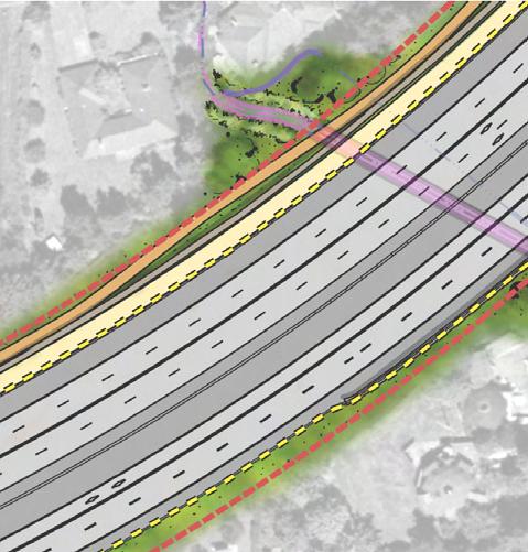
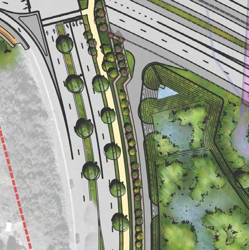
9 SR 520 Regional Bicycle Path The SR 520 regional bicycle path would be a 14-foot-wide, Class I, paved regional trail that would comply with the ADA. The path would originate from an at-grade connection with Evergreen Point Road (which would also connect to the existing Points Loop Trail at this location) and extend east to South Bellevue Way. The path would cross 84th Avenue NE at-grade. At both South Bellevue Way and 92nd Avenue NE, switchbacks onto the elevated crossings would be constructed to access the local streets. In addition, undercrossings would be provided at South Bellevue Way and 92nd Avenue NE for the nonmotorized traffic continuing east. As part of a separate project, WSDOT would extend the SR 520 regional bicycle path west from Evergreen Point Road across the Evergreen Point Bridge. Lids and Overcrossings Lids or overcrossings over SR 520 would be constructed at Evergreen Point Road, 84th Avenue NE, 92nd Avenue NE, and South Bellevue Way. Lids would incorporate pedestrian plazas and open spaces and integrate the new bicycle and pedestrian facilities into the surrounding communities. Exhibits 7-2 through 7-5 show early concepts for the lid designs, including how the project s nonmotorized facilities would be incorporated into the lids and overcrossing. Points Loop Trail The Points Loop Trail would be reconstructed between Evergreen Point Road and 92nd Avenue NE, parallel to and north of SR The reconstructed and new trail sections would be 9 feet wide, with 2-footwide gravel shoulders on each side. The gradient of the reconstructed and new trail portions would match to the existing trail. Like the existing trail, the final trail configuration would not be ADA-compliant. The trail would be reconstructed directly adjacent to the new SR 520 regional bicycle pedestrian path along most of its length and share access and connection points with that new path at street crossings. This cross-connectivity is part of the reason why a non-ada compliance facility is considered acceptable for the project. The trail is intended to serve community recreational purposes with generally slower speeds than would occur on the SR 520 bicycle path. EA_DR_TRAN_CH07_NONMOTORIZED.DOC 7-9


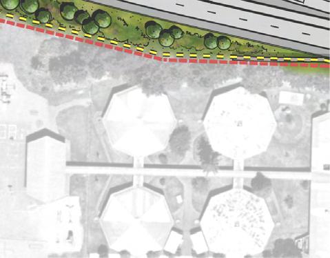
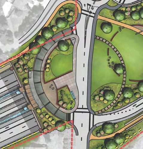
10 EVERGREEN POINT RD V 520 SR 520 regional bike/ pedestrian path Transit station Park-and-ride \\simba\proj\parametrix\180171\graphics\x_ea_eastside\tran\ea_dr_tran_ex07-02_gr000_evergreenptrdinterchangeliddesignconcept_final.ai Exhibit 7-2. Evergreen Point Road Interchange and Lid Design Concept Medina to SR 202: Eastside Transit and HOV Project


11 84TH AVE NE Connection to local and regional bike/ pedestrian path SR 520 regional bike/pedestrian path V 520 \\simba\proj\parametrix\180171\graphics\x_ea_eastside\tran\ea_dr_tran_ex07-03_gr000_84thaveneinterchangeliddesignconcept_final.ai Exhibit th Avenue NE Interchange and Lid Design Concept Medina to SR 202: Eastside Transit and HOV Project


12 92ND AVE NE SR 520 regional bike/pedestrian path New pickup/ drop-off area Transit station V 520 \\simba\proj\parametrix\180171\graphics\x_ea_eastside\tran\ea_dr_tran_ex07-04_gr000_92ndinterchangeliddesignconcept_final.ai Exhibit nd Avenue NE Interchange and Lid Design Concept Medina to SR 202: Eastside Transit and HOV Project


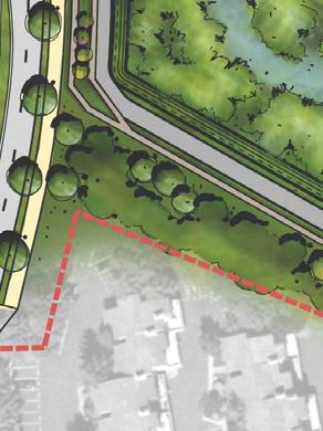
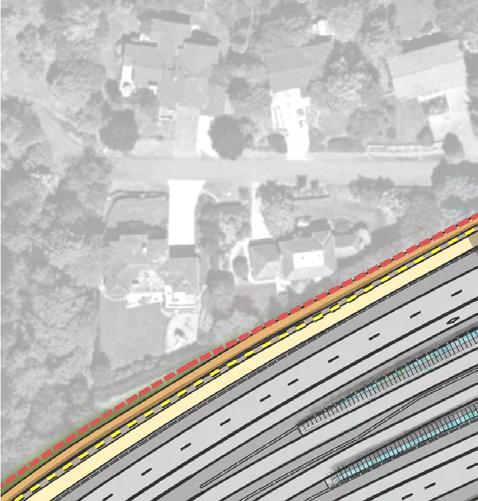
13 SR 520 regional bike/ pedestrian path Connection to local/regional bike/pedestrian path POINTS DR NE NORTHUP WAY V 520 BELLEVUE WAY NE \\simba\proj\parametrix\180171\graphics\x_ea_eastside\tran\ea_dr_tran_ex07-05_gr000_sobellwyinterchngdesignconcept_final.ai Exhibit 7-5. South Bellevue Way Interchange and Overcrossing Design Concept Medina to SR 202: Eastside Transit and HOV Project
14 Local Street and Trail Connections and Pedestrian Facilities Sidewalks would be reconstructed to meet local design codes on both sides of 84th Avenue NE, 92nd Avenue NE, and Evergreen Point Road to match the SR 520 overcrossings that would be constructed. A 12- foot wide shared-use path (i.e., Class I facility) would be constructed on the east side of South Bellevue Way, extending from approximately 300 feet south of SR 520 to Northup Way. This facility would place all pedestrian and bicycle traffic on the east side of South Bellevue Way to improve safety for facility users and allow efficient movement of local and freeway traffic with the reconfigured interchange. A 14-foot-wide Class I bicycle/pedestrian facility would be constructed on the south side of Northup Way from the intersection with 108th Avenue NE to South Bellevue Way. East of 108th Avenue NE, 5-footwide bicycle lanes would be added to both sides of Northup Way, extending to the existing bike lanes on Northup Way. Five-foot wide on-street bicycle lanes (i.e., Class II facility) would be constructed on both sides of 108th Avenue NE, extending from approximately 300 feet south of SR 520 to approximately 100 feet north of Northup Way. An existing park-and-ride lot south of SR 520 at Evergreen Point Way would be reconstructed and a drop-off and pick-up area located north of SR 520 on 92nd Avenue NE would be reconfigured to improve vehicle access and traffic flow. Improvements to these bus access points could facilitate transfer of bicycles and pedestrians to buses. Design and location of these lots would be incorporated into the proposed lid configurations to create safe and effective nonmotorized access. How have the nonmotorized concepts changed since the Draft EIS? While the scope of the nonmotorized project work has remained generally unchanged since the project was evaluated as part of the Draft EIS, there have been changes to design concepts. These changes have been incorporated into the project after ongoing coordination with local jurisdictions. Changes to SR 520 Regional Bicycle Path To enhance connections to local communities and create a more light and open nonmotorized travel experience, the SR 520 regional bicycle EA_DR_TRAN_CH07_NONMOTORIZED.DOC 7-14
15 path would be constructed at approximately the same grade as SR 520. The new path design includes an at-grade crossing of both Evergreen Point Road and 84th Avenue NE, while maintaining a slope not greater than 5 percent. The previous design placed the path at a lower elevation than SR 520 in places at the base of relatively tall freeway retaining walls, which would create a canyon effect. The previous design also terminated the path at 100th Lane NE, whereas now the path extends to South Bellevue Way. Changes to Lid and Overcrossing Access and Design Early concepts of the nonmotorized facilities included undercrossings at the proposed lids but no access to the top of the lids. Surface trails and overcrossings have now been added to the design concepts that would enhance bicycle and pedestrian access to local streets and transit facilities at two locations. The SR 520 regional bicycle path would continue underneath the lids to maintain a regional nonmotorized transportation connection, and design now incorporates access to local streets via switchbacks that are part of the lid design. The alignment of the Evergreen Point Road lid was changed to allow a street-level connection to the SR 520 regional bicycle path. This change maintains better connections to local communities. The alignment of the lid at 84th Avenue NE has been shifted to the east to provide better trail connectivity and new open space area. Open space allowing connection to Hunts Point Park over the lid is now proposed where a freeway loop ramp was previously to be constructed. The loop ramp has been replaced with a half-diamond conceptual design. At 92nd Avenue NE, a roundabout and improvements to the drop-off and pick-up lot have been added. The interchange at South Bellevue Way has been reconfigured from a loop ramp to a half-diamond design, changing the overcrossing to facilitate better vehicle operations and bicycle and pedestrian access to and from the SR 520 bicycle path. The new concept would shift all nonmotorized traffic to the east side of 84th Avenue NE for greater pedestrian and bicycle safety and to separate freeway and local traffic. At 108th Avenue NE, no changes have been made to nonmotorized design concepts since the Draft EIS. EA_DR_TRAN_CH07_NONMOTORIZED.DOC 7-15
16 Changes to Points Loop Trail The Points Loop Trail would originally have replaced the existing trail north of SR 520 as the alignment of SR 520 shifted to the north. Now, the trail between Evergreen Point Road and 92nd Avenue NE would be reconstructed to accommodate the shift in SR 520. The City of Bellevue would be able to extend the Points Loop Trail farther east if so desired. What would the nonmotorized experience be like under the No Build Alternative? With or without the project, there could be some improvements to regional nonmotorized connectivity along the SR 520 corridor. Other trails and trail segments are proposed to be constructed in the region, which would enhance the experience of local trail users by providing newer trails in more locations for recreational activities such as bicycling, walking, or jogging. These other trails could also create shortdistance commute opportunities. Trails that other jurisdictions construct could also create additional regional connectivity and opportunities for local bicycling and walking; however, the SR 520 regional bicycle path and other nonmotorized facilities through the project corridor would remain critical components of full-trail connectivity in the region, and these facilities would not be constructed if the proposed project is not built. Pedestrians would continue to use the same trails and area sidewalks and crosswalks that they do now if the proposed project is not built. Through the Evergreen Point Road and 84th and 92nd Avenue NE interchanges, relatively low traffic volumes combined with existing features would continue to provide adequate pedestrian facilities. Pedestrian movements through the South Bellevue Way interchange area would continue to be challenging or nonexistent. On 108th Avenue NE, existing sidewalks would continue to accommodate pedestrian traffic. If the proposed project is not built, none of the project s proposed improvements would be made to bus stops or trails near bus stops, and the current ability to combine nonmotorized transportation with bus transit would remain unchanged. Within the project site, commuting bicyclists would continue to rely on the existing non-ada-compliant Points Loop Trail and area roadways to reach transit stops. EA_DR_TRAN_CH07_NONMOTORIZED.DOC 7-16
17 Opportunities for pedestrian access to transit would remain in place using area streets, the Points Loop Trail, and the reconstructed parkand-ride lot at Evergreen Point Road. What would the nonmotorized experience be like under the Build Alternative? With the project, the bicycle commute experience along the project corridor would be enhanced by the new SR 520 regional bicycle path, improvements to the Points Loop Trail, and other proposed facilities that would accommodate commuting bicyclists and recreational users. The new facilities would improve bicycle and pedestrian connections to existing trails, and another link would be created in a series of regional bicycle facilities. Although a nonmotorized facility crossing the SR 520 floating bridge would not be constructed by this project, the new path would provide better access to transit service for cyclists and pedestrians at the Evergreen Point Freeway Transit Station. With new bicycle facilities provided as part of the proposed project, cyclists would have access to wider paths, improved (i.e., less steep) grades, and more clearly signed routes. Once bicyclists reach the transit stations, they would also have improved waiting areas that are separated from the main freeway traffic with a noise buffer. When crossing Bellevue Way, cyclists and pedestrians would no longer need to wait for the traffic signal to change, because there would be a tunnel under Bellevue Way which would improve travel time for bicyclists and remove bicycles from the motorized traffic stream, thus improving safety. Overall, recreational bicycle and pedestrian safety and convenience would be improved through the project site along the SR 520 corridor with the addition of the new SR 520 regional bicycle path adjacent to the Points Loop Trail for bicyclists traveling at higher speeds. The Points Loop Trail would remain as a more scenic facility, following the existing terrain consistent with ECDC guidelines for local trails. The SR 520 regional bicycle path would be a direct route through the SR 520 corridor. It would be ADA compliant, including generally less steep grades than the Points Loop Trail. Elevations of the SR 520 regional bicycle path would be about the same as SR 520. The path would be designed to allow efficient travel through intersections, with grade separation at each intersection. Switchbacks from the path onto the new EA_DR_TRAN_CH07_NONMOTORIZED.DOC 7-17
18 street overcrossings would allow access to local streets. The path and trail would fit into the landscape at each local street overcrossing, with wayfinding signs, seating areas, lighting, and other features and amenities, consistent with design guidelines. Access to both the Points Loop Trail and SR 520 regional bicycle path would be provided at Evergreen Point Road. The lid over SR 520 at this location would incorporate a plaza setting and transportation facilities. The lid would be landscaped, including use of trees, and the landscaping would tie the look and feel of the lid to that of the Fairweather Park open space on the northeast corner of the lid. An overlook to the west would be maintained, and seating would be created. The Evergreen Point Road Park and-ride lot would be incorporated into the lid design and would be easily accessible, with elevators and stairs between the plaza and the transit station. Wayfinding signs would be provided to orient passengers to transit options. Bicycle lockers allowing bicyclists to securely park their bikes and take a bus to their final destination would also be provided to increase bicycle commute flexibility. The new lid at 84th Avenue NE would create bicycle and pedestrian connectivity and access between neighborhoods on each side of SR 520, especially to the Hunts Point Town Hall and Hunts Point Park. A landscaped plaza and seating would be created, with a walking path incorporated into the lid design. Wayfinding signs would be incorporated for the SR 520 regional bicycle path. At 92nd Avenue NE, the connection between the SR 520 regional bicycle path and the Points Loop Trail would be clearly marked. The reconstructed portion of the Points Loop Trail would merge smoothly back into the existing trail in this vicinity. An overlook with a view of Yarrow Bay wetlands would be provided, and the lid over SR 520 would be landscaped. As with Evergreen Point Road, transit facilities would be incorporated into the 92nd Avenue NE lid design, including a transit station with elevator and stair access, wayfinding signs for transit passers, and bike lockers. The South Bellevue Way overcrossing of SR 520 would provide separated bicycle and pedestrian movement through the area with incorporation of the new Class I trail along the east side of the roadway. EA_DR_TRAN_CH07_NONMOTORIZED.DOC 7-18
19 The facility would be landscaped to create visual separation from vehicular traffic. The new bicycle lanes in both directions at 108th Avenue NE would create a link to existing bicycle facilities and improve the ability of bicyclists to move safely through the area. EA_DR_TRAN_CH07_NONMOTORIZED.DOC 7-19
20
C C C
 C-012-001 Thank you for your support for the creation of new public space and nonmotorized access between downtown and the waterfront through the Overlook Walk, the East-West Connections, and the Promenade.
5. RUNNINGWAY GUIDELINES
 5. RUNNINGWAY GUIDELINES These guidelines should be considered collectively when making runningway decisions. A runningway is the linear component of the transit system that forms the right-of-way reserved
RZC Appendix 8A Marymoor Subarea Street Requirements
 RZC Appendix 8A Marymoor Subarea Street Requirements For additional design details for Marymoor Subarea infrastructure, refer to the 2017 Marymoor Subarea Infrastructure Planning Report. STREET REQUIREMENTS
MAG Town of Cave Creek Bike Study Task 6 Executive Summary and Regional Significance Report
 Page 1 MAG Town of Cave Creek Bike Study Task 6 Executive Summary and Regional Significance Report August 1, 2012 MAG Project #481 Page 2 Task 6 Executive Summary and Regional Significance Report Introduction
See Figure 38, Existing Nonmotorized Connections.
 Nonmotorized Connections Existing Nonmotorized Connections Pedestrian, vehicle and bike traffic access and movements are confined primarily to Penny Drive on campus. Due to the steep slope along the length
APPENDIX A: Complete Streets Checklist DRAFT NOVEMBER 2016
 APPENDIX A: Complete Streets Checklist DRAFT NOVEMBER 2016 Complete Streets Checklist MetroPlan Orlando s Complete Streets Checklist is an internal planning tool for staff to further implementation of
CITY OF SEATTLE RESOLUTION. WHEREAS, the Washington State Department of Transportation (WSDOT) led the Seattle
 led the Seattle") SDOT SR0 Design Refinements RES August, 0 Version #D 0 CITY OF SEATTLE RESOLUTION..title A RESOLUTION relating to the State Route 0, Interstate to Medina Bridge Replacement and High Occupancy Vehicle Project;
SDOT SR0 Design Refinements RES August, 0 Version #D 0 CITY OF SEATTLE RESOLUTION..title A RESOLUTION relating to the State Route 0, Interstate to Medina Bridge Replacement and High Occupancy Vehicle Project;
Existing Transportation System
 < Open for Additional Text Transportation System Existing Transportation System This section describes vehicular transportation associated with Children s. transportation are described in a separate section
Appendix T CCMP TRAIL TRAFFIC & TRANSPORTATION DESIGN STANDARD
 Appendix T CCMP 3.3.4 TRAIL TRAFFIC & TRANSPORTATION DESIGN STANDARD 3.3.4 Trail Traffic and Transportation Design Multi-use trails have certain design standards, which vary depending on the agency that
General Design Factors
 Chapter 3: 3-1.0 Introduction General Design Factors Mn/DOT s goals include encouraging and accommodating safe bicycling. From a design perspective, these goals are achieved by first having an understanding
ACTIVE TRANSPORTATION
 ACTIVE TRANSPORTATION Mobility 2040 Supported Goals Improve the availability of transportation options for people and goods. Support travel efficiency measures and system enhancements targeted at congestion
What Is a Complete Street?
 Session 5 Charleen Zimmer, AICP, Zan Associates May 5-7, 2010 What Is a Complete Street? May 2010 5-1 Not a Complete Street More of a Complete Street May 2010 5-2 Benefits of Complete Streets Safety for
2.0 Existing Conditions
 20 2.0 Existing Conditions 2.1 Land Use, Future Growth Patterns, Physical Barriers Geographic Overview Sutter County s land use pattern is characterized by extensive agricultural areas, significant natural
Off-road Trails. Guidance
 Off-road Trails Off-road trails are shared use paths located on an independent alignment that provide two-way travel for people walking, bicycling, and other non-motorized users. Trails specifically along
Clackamas County Comprehensive Plan
 ROADWAYS The County s road system permits the movement of goods and people between communities and regions, using any of a variety of modes of travel. Roads provide access to virtually all property. They
Appendix 3 Roadway and Bike/Ped Design Standards
 Appendix 3 Roadway and Bike/Ped Design Standards OTO Transportation Plan 2040 4/20/2017 Page A3-1 Adopted Standards The adopted OTO Design Standards and Major Thoroughfare Plan are contained herein.
NM-POLICY 1: Improve service levels, participation, and options for non-motorized transportation modes throughout the County.
 Transportation PRINCE WILLIAM COUNTY 2008 COMPREHENSIVE PLAN NON-MOTORIZED PLAN CONTENTS Goals, Policies, and Action Strategies Table 4 (Bike Facility Classifications and Descriptions) Table 5 (Bike Facility
Active Transportation Facility Glossary
 Active Transportation Facility Glossary This document defines different active transportation facilities and suggests appropriate corridor types. Click on a facility type to jump to its definition. Bike
Duwamish Way-finding and CTR Report
 V. North Tukwila When the North Tukwila Manufacturing and Industrial Center was designated in 1992 as part of the region s land use and transportation plan, the plan called for the area to set a light-rail
FOCUS AREA 1 - Alberta Avenue Pocket Park 3 (121 Ave and 92 St)
") FOCUS AREA 1 - Alberta Avenue Pocket Park 3 (121 Ave and 92 St) New benches Plant evergreen trees Widen existing sidewalk from 1.5m to 1.8m Marked crosswalk 1.8m wide sidewalk Add pedestrian oriented lights
FOCUS AREA 1 - Alberta Avenue Pocket Park 3 (121 Ave and 92 St) New benches Plant evergreen trees Widen existing sidewalk from 1.5m to 1.8m Marked crosswalk 1.8m wide sidewalk Add pedestrian oriented lights
Chapter 6 Transportation Plan
 Chapter 6 Transportation Plan Transportation Plan Introduction Chapter 6 Transportation Plan Transportation Plan Introduction This chapter describes the components of Arvada s transportation system, comprised
Safe Streets. City of Lake Forest Park. March 21, 2017
 Safe Streets City of Lake Forest Park March 21, 2017 1 01 WELCOME 2 Agenda WELCOME WHAT IS THIS PROJECT? CONTEXT DRAFT CITYWIDE PROJECTS EXERCISE INTRODUCTION 3 02 WHAT IS THIS PROJECT? 4 WHAT IS THIS
CHAPTER 16 PEDESTRIAN FACILITIES DESIGN AND TECHNICAL CRITERIA TABLE OF CONTENTS
 CHAPTER 16 PEDESTRIAN FACILITIES DESIGN AND TECHNICAL CRITERIA TABLE OF CONTENTS Section Title Page 16.1 General... 16-1 16.1.1 AASHTO Reference... 16-1 16.1.2 ADA Requirements... 16-1 16.2 Sidewalks...
Roosevelt Estates Neighborhood Improvements
 Roosevelt Estates Neighborhood Improvements Transportation Alternatives Application May 5 th, 2016 Qualifying Activities Construction of on-road and off-road trail facilities for pedestrians, bicyclists,
CURBSIDE ACTIVITY DESIGN
 5 CURBSIDE ACTIVITY DESIGN This chapter provides design guidance for separated bike lanes adjacent to curbside activities including parking, loading and bus stops. Typical configurations are presented
Non-Motorized Transportation 7-1
 Non-Motorized Transportation 7-1 Transportation facilities no longer mean just accommodating a vehicle powered by a combustion engine. Pedestrian and non-motorized facilities are important modes of travel
Gordon Proctor Director Policy on Accommodating Bicycle and Pedestrian Travel on ODOT Owned or Maintained Facilities
 Approved: Policy: 20-004(P) Responsible Office: Planning Gordon Proctor Director Policy on Accommodating Bicycle and Pedestrian Travel on ODOT Owned or Maintained Facilities I. POLICY STATEMENT: This policy
NJDOT Complete Streets Checklist
 Background The New Jersey Department of Transportation s Complete Streets Policy promotes a comprehensive, integrated, connected multi-modal network by providing connections to bicycling and walking trip
Multimodal Through Corridors and Placemaking Corridors
 68 Multimodal Through Corridors and Placemaking Corridors Corridors have different functions in a region. Some corridors are used to get smoothly and rapidly through a region or to get quickly to major
INDOT Complete Streets Guideline & Policy
 INDOT Complete Streets Guideline & Policy INTRODUCTION The Complete Streets guidelines build upon multiple efforts and promote a multimodal transportation system that is integrated and sustains land use
Chapter 9: Pedestrians and Bicyclists
 Chapter 9: Pedestrians and Bicyclists Walking and bicycling are essential modes of transportation. These modes allow people to travel without contributing to congestion and air pollution, to access other
Chapter 3 DESIGN SPECIFICATIONS
 Brampton PathWays Planning and Design Guidelines 27 Chapter 3 DESIGN SPECIFICATIONS 3.1 CLASS 1 MULTI-USE PATH Off-road multi-use trails are the backbone of the Brampton PathWays Network. They are typically
5 CIRCULATION AND STREET DESIGN
 5 CIRCULATION AND STREET DESIGN This chapter describes circulation and streetscape improvements proposed for the Northwest Chico Specific Plan Area. It includes detailed design specifications for existing
St. Francis Drive through the City of Santa Fe Corridor Study
 VII. ENGINEERING AND ENVIRONMENTAL EVALUATION TRAIL CONNECTIVITY In the southern portion of the Corridor there is a lack of a sidewalk, trail or bicycle facility within the right-ofway. However, the City
Lee s Summit Road Improvement Study Public Open House June 7, 2007 Summary of Comment Card Responses
 Lee s Summit Road Improvement Study Public Open House June 7, 2007 Summary of Comment Card Responses Introduction At the Lee s Summit Road Improvement Study Public Open House held Thursday, June 7, 2007
Agenda. Overview PRINCE GEORGE S PLAZA METRO AREA PEDESTRIAN PLAN
 PRINCE GEORGE S PLAZA METRO AREA PEDESTRIAN PLAN May 28, 2008 Agenda Welcome and introductions Project overview and issue identification Planning context and strengths Design challenges and initial recommendations
PRINCE GEORGE S PLAZA METRO AREA PEDESTRIAN PLAN
 PRINCE GEORGE S PLAZA METRO AREA PEDESTRIAN PLAN May 28, 2008 Agenda Welcome and introductions Project overview and issue identification Planning context and strengths Design challenges and initial recommendations
Board-Approved Funding Awards for Cycle 4 Active Transportation Grant Program Projects (in Order of Project Rankings) Approved on
 Approved on") CAPITAL Large Category Projects Board-Approved Funding Awards for Cycle 4 Active Transportation Grant Program Projects (in Order of Project Rankings) Approved on 07-27-18 1 La Mesa University Ave Pedestrian
CAPITAL Large Category Projects Board-Approved Funding Awards for Cycle 4 Active Transportation Grant Program Projects (in Order of Project Rankings) Approved on 07-27-18 1 La Mesa University Ave Pedestrian
Make Lincoln Highway an economically vibrant corridor that is safe, efficient, and beautiful for local residents and visitors.
 Lincoln Highway Streetscape Plan Stakeholder Workshop #2 Handout Contents Introduction and Project Vision Planning Principles Specific Recommendations including a Proposed Typical Roadway Section Renderings
Anne Arundel County BICYCLE, PEDESTRIAN, TRANSIT ASSESSMENT GUIDELINES
 Anne Arundel County BICYCLE, PEDESTRIAN, TRANSIT ASSESSMENT GUIDELINES December 2018 TABLE OF CONTENTS I. Executive Summary 3 II. When Is A Bicycle Pedestrian Transit Assessment (BPTA) Required? 4 III.
Alaskan Way, Promenade, and Overlook Walk Final EIS
 I-065-001 As described in Section 3.7.2 of the Draft EIS, the loss of on-street and off-street parking may require drivers to park off-street or travel farther to find available on-street or off-street
10A. DATE: October 5, Pedestrian and Bicycle Advisory Committee. Kevin Colin, Deputy Planning Manager Curt Bates, City Engineer
 10A DATE: October 5, 2016 TO: PREPARED BY: SUBJECT: Pedestrian and Bicycle Advisory Committee Kevin Colin, Deputy Planning Manager Curt Bates, City Engineer Discussion and Provide Comments, Associated
REGIONAL BICYCLE AND PEDESTRIAN DESIGN GUIDELINES
 REGIONAL BICYCLE AND PEDESTRIAN DESIGN GUIDELINES November 16, 2011 Deb Humphreys North Central Texas Council of Governments Bicycle and Pedestrian Advisory Committee Snapshot of the Guide 1. Introduction
ROUTE 81 CORRIDOR STUDY DESIGN CONCEPTS
 RT 81 Corridor Study CLINTON ROUTE 81 CORRIDOR STUDY DESIGN CONCEPTS View north on High Street, with potential improvements to the streetscape Draft Recommendations November 8 th, 2018 TOWN OF CLINTON
o n - m o t o r i z e d transportation is an overlooked element that can greatly enhance the overall quality of life for the community s residents.
 N o n - m o t o r i z e d transportation is an overlooked element that can greatly enhance the overall quality of life for the community s residents. 84 Transportation CHAPTER 11 INTRODUCTION Transportation
Solana Beach Comprehensive Active Transportation Strategy (CATS)
") Solana Beach Comprehensive Active Transportation Strategy (CATS) 3.0 Goals & Policies The Solana Beach CATS goals and objectives outlined below were largely drawn from the Solana Beach Circulation Element
Solana Beach Comprehensive Active Transportation Strategy (CATS) 3.0 Goals & Policies The Solana Beach CATS goals and objectives outlined below were largely drawn from the Solana Beach Circulation Element
ACTIVE TRANSPORTATION/NONMOTORIZED TRANSPORTATION
 ACTIVE TRANSPORTATION/NONMOTORIZED TRANSPORTATION BACKGROUND Active transportation, also known as nonmotorized transportation, is increasingly recognized as an important consideration when planning and
2.0 LANE WIDTHS GUIDELINE
 2.0 LANE WIDTHS GUIDELINE Road Engineering Design Guidelines Version 2.0.1 May 2018 City of Toronto, Transportation Services City of Toronto Page 0 Background In early 2014, Transportation Services initiated
TRANSPORTATION COMMISSION Agenda Staff Report
 TRANSPORTATION COMMISSION Agenda Staff Report Agenda Item No. 5.a DATE: JULY 31, 2014 TO: FROM: SUBJECT: TRANSPORTATION COMMISSION COMMUNITY DEVELOPMENT DEPARTMENT - PLANNING DRAFT OLYMPIC CORRIDOR PREFERRED
Chapter 3: Multi-Modal Circulation and Streetscapes
 CHAPTER 3: MULTI-MODAL CIRCULATION AND STREETSCAPES Chapter 3: Multi-Modal Circulation and Streetscapes Overview Streetscape improvements have already been completed for Depot Street between Main Avenue
section 4 Existing Conditions, Issues, and Options
 section 4 Existing Conditions, Issues, and Options 4.0 Existing Conditions, Issues, and Options This section analyzes each segment of the corridor on a street to street basis. Each segment is discussed
LANCASTER CITY BICYCLE NETWORK
 LANCASTER CITY BICYCLE NETWORK Downtown Merchants Meeting Wednesday, July 19, 2017 http://www.lancasteratp. DOWNTOWN WALKABILITY ANALYSIS What changes can be made, in the least amount of time, and for
Bicycle and Pedestrian Chapter TPP Update Overview. TAB September 20, 2017
 Bicycle and Pedestrian Chapter TPP Update Overview TAB September 20, 2017 Bicycling & Walking in the Twin Cities Where are we now? The Bike-Pedestrian system Current trends New developments Where are we
Bike San Mateo County San Mateo County Bicycle Plan Recommendations August 30, 2010
 Policy and Procedures Develop and Implement a Complete Streets Policy to comply with DD-64-R1 and AB1358 Commencing January 1, 2011, AB1358 requires that the legislative body of a city or county, upon
Cycle Track Design Best Practices Cycle Track Sections
 Design Best Practices Sections It is along street segments where the separation and protection methods of cycle tracks offer more comfort than conventional bicycle lanes, and are more attractive to a wide
HARRISON STREET/OAKLAND AVENUE COMMUNITY TRANSPORTATION PLAN
 HARRISON STREET/OAKLAND AVENUE Community Workshop #4: Draft Plan Review December 3, 2009 D E S I G N, C O M M U N I T Y & E N V I R O N M E N T INTRODUCTIONS Key Project Staff: Alisa Shen, Project Manager,
Dear Mayor Murray, Top SR-520 Design Innovations and Remaining Opportunities
 Dear Mayor Murray, Thank you for your leadership building a transportation system that moves people efficiently throughout the region, and creates healthy places to live, work, and play. We are glad you
George Washington Bridge Restoring the George Construction Program Supplemental Information on Bicycle and Pedestrian Access
 George Washington Bridge Restoring the George Construction Program Supplemental Information on Bicycle and Pedestrian Access The replacement of the George Washington Bridge suspender ropes is part of the
10.0 CURB EXTENSIONS GUIDELINE
 10.0 CURB EXTENSIONS GUIDELINE Road Engineering Design Guidelines Version 1.0 March 2017 City of Toronto, Transportation Services City of Toronto Page 0 Background In early 2014, Transportation Services
3.9 Recreational Trails and Natural Areas
 3.9 Recreational Trails and Natural Areas 3.9.1 Introduction Parks and other recreational facilities such as trails, bicycle routes, and open space are important community resources. This section discusses
Bicycle and Pedestrian Facilities Toolbox (Excerpt from Figure 3.1)
") Appendix B Neighborhood Connections Summaries This Appendix is a supplement to the information presented in Chapter 3 Connect People. The Appendix includes a summary or profile for each of the proposed
Appendix B Neighborhood Connections Summaries This Appendix is a supplement to the information presented in Chapter 3 Connect People. The Appendix includes a summary or profile for each of the proposed
Corpus Christi Metropolitan Transportation Plan Fiscal Year Introduction:
 Introduction: The Safe, Accountable, Flexible, Efficient Transportation Equity Act: A Legacy for Users (SAFETEA-LU) has continued the efforts started through the Intermodal Surface Transportation Efficiency
Chapter 2: Standards for Access, Non-Motorized, and Transit
 Standards for Access, Non-Motorized, and Transit Chapter 2: Standards for Access, Non-Motorized, and Transit The Washtenaw County Access Management Plan was developed based on the analysis of existing
2018 Pedestrian and Bicycle and Safe Routes to School Application for Funding Page 1 of 31
 2018 Pedestrian and Bicycle and Safe Routes to School Application for Funding Page 1 of 31 2018 Pedestrian and Bicycle and Safe Routes to School Application for Funding Part 1: General Information Funding
Accommodating Pedestrians in the Work Zone
 Accommodating Pedestrians in the Work Zone Guidance for Section C Plan Preparers Some impacts cannot be avoided and those impacts apply to residents, businesses, motorists, and pedestrians alike. However,
Transportation Improvement Plan SECTION2
 The transportation improvement plan, in combination with the land use concept plan, provides the framework for development in Romeoville s East Side TOD Area. Components included in this plan address:
Tonight is for you. Learn everything you can. Share all your ideas.
 Strathcona Neighbourhood Renewal Draft Concept Design Tonight is for you. Learn everything you can. Share all your ideas. What is Neighbourhood Renewal? Creating a design with you for your neighbourhood.
9/25/2018. Multi-Modal Level of Service (MMLOS) Bianca Popescu, Transportation Planner
 Bianca Popescu, Transportation Planner") Multi-Modal Level of Service (MMLOS) Bianca Popescu, Transportation Planner 1 What is MMLOS? Is this a nice place to walk? Is this a nice place to bike? Is transit convenient? Bottom line - Are there options
Multi-Modal Level of Service (MMLOS) Bianca Popescu, Transportation Planner 1 What is MMLOS? Is this a nice place to walk? Is this a nice place to bike? Is transit convenient? Bottom line - Are there options
Physical Implications of Complete Streets Policies
 Presentation Overview Physical Implications of Complete Norm Cox, ASLA, LLA Landscape Architect Ann Arbor, Michigan, 10:45 to Noon What Are Complete Streets? What Matters to Bicyclists and Pedestrians
Land Use Bicycle Spaces Required Type Residential
 SAMPLE ORDINANCES AND RESOLUTIONS APPENDIX B SAMPLE BICYCLE PARKING ORDINANCE Land Use Bicycle Spaces Required Type Residential Single Family/Two Family N/A N/A Apartment/Townhome 1 per unit plus 6 space
UNIVERSITY OF WASHINGTON TO SOUND TRANSIT U-LINK PEDESTRIAN CONNECTION PROJECT EIS ADDENDUM
 UNIVERSITY OF WASHINGTON TO SOUND TRANSIT U-LINK PEDESTRIAN CONNECTION PROJECT EIS ADDENDUM UNIVERSITY OF WASHINGTON SOUND TRANSIT January 2011 EIS Addendum for the University of Washington to Sound Transit
Memorandum. Exhibit 60 SSDP To: Jenny Bailey, Senior Planner. From: Bill Schultheiss, P.E. (WA. P.E. #46108) Date: June 20, 2017
 Date: June 20, 2017") Memorandum To: Jenny Bailey, Senior Planner From: Bill Schultheiss, P.E. (WA. P.E. #46108) Date: June 20, 2017 Re: East Lake Sammamish Trail, Segment 2B Review King County has asked Toole Design Group
Memorandum To: Jenny Bailey, Senior Planner From: Bill Schultheiss, P.E. (WA. P.E. #46108) Date: June 20, 2017 Re: East Lake Sammamish Trail, Segment 2B Review King County has asked Toole Design Group
Montgomery County Life Sciences Center Loop Trail
 Montgomery County Life Sciences Center Loop Trail Advisory Committee Meeting #1 February 10, 2015 Agenda 1. Project Background 2. Existing Conditions Analysis 3. Examples from Elsewhere 4. Discussion Project
Operations -- Transit From: N/A To: N/A. Improvement Type: Regionally Significant: No
 Central Puget Sound Regional 2017-2020 Transportation Improvement Program Amendments and Corrections to be included in the 2017-20 STIP PSRC's Amendment 2017-08 County: King List of 17-08 Amendment Projects:
Item No. 14 Town of Atherton
 Item No. 14 Town of Atherton CITY COUNCIL STAFF REPORT CONSENT AGENDA TO: THROUGH: FROM: HONORABLE MAYOR AND CITY COUNCIL GEORGE RODERICKS, CITY MANAGER MICHAEL KASHIWAGI, COMMUNITY SERVICES DIRECTOR MARTY
ADA on Construction. Guidance for Section C Plan Preparers
 ADA on Construction Guidance for Section C Plan Preparers Some impacts cannot be avoided and those impacts apply to residents, businesses, motorists, and pedestrians alike. However, good planning can minimize
Lincoln Highway Streetscape Plan Concept Plan
 Lincoln Highway Streetscape Plan Concept Plan November 14, 2014 Introduction This report provides a summary of conceptual transportation, land use, and design recommendations in the Lincoln Highway Streetscape
SECTION 1 - TRAFFIC PLANNING
 SECTION 1 - TRAFFIC PLANNING 1.1 TRAFFIC OPERATIONS 1.1.1 Roadway Functional Classification The Multnomah County Comprehensive Framework Plan s Policy 34: Trafficways and the Functional Classification
BETHEL ROAD AND SEDGWICK ROAD CORRIDOR STUDY
 DRAFT PLAN City Council Meeting August 14, 2017 STUDY AREA Sedgwick Corridor State Route 160, principal arterial with Class 3 access management designation, commuter and freight route, connection to SR
General Plan Circulation Element Update Scoping Meeting April 16, 2014 Santa Ana Senior Center, 424 W. 3rd Street, Santa Ana, CA 92701
 General Plan Circulation Element Update Scoping Meeting April 16, 2014 Santa Ana Senior Center, 424 W. 3rd Street, Santa Ana, CA 92701 Meeting Agenda 1. Purpose of Scoping Meeting 2. Project Overview 3.
Appendix F: Wayfinding Protocol and Best Practices
 Appendix F: Wayfinding Protocol and Best Practices Table of Contents Introduction... 259 Current Practice... 259 Policy and Regulatory Framework... 260 Best Practices... 262 Chicago, IL... 262 Seattle,
STONY PLAIN ROAD STREETSCAPE
 Jasper Place Revitalization Strategy: Vision The people involved in the Jasper Place Revitalization Strategy envision: Goal 1: Feeling safe in our community Create a community where feeling safe is common--where
SOLANA BEACH BICYCLE TRANSPORTATION PLAN SECOND ADDENDUM
 SOLANA BEACH BICYCLE TRANSPORTATION PLAN SECOND ADDENDUM Prepared by the City of Solana Beach January 2005 Introduction In June of 1993, the Solana Beach City Council adopted a Bikeway Master Plan as directed
7/23/2017 VIA . Michael Hanebutt City of Sacramento Community Development Department 300 Richards Boulevard, 3 rd Floor Sacramento, CA 95811
 7/23/2017 VIA EMAIL Michael Hanebutt City of Sacramento Community Development Department 300 Richards Boulevard, 3 rd Floor Sacramento, CA 95811 RE: 65 th Street Apartments (DR17-220) Dear Mr. Hanebutt:
This chapter describes the proposed circulation system and transportation alternatives associated with
 5.0 Circulation 5.1 OVERVIEW This chapter describes the proposed circulation system and transportation alternatives associated with West Landing, and summarize the information contained in the Existing
Exhibit 1 PLANNING COMMISSION AGENDA ITEM
 Exhibit 1 PLANNING COMMISSION AGENDA ITEM Project Name: Grand Junction Circulation Plan Grand Junction Complete Streets Policy Applicant: City of Grand Junction Representative: David Thornton Address:
Watertown Complete Streets Prioritization Plan. Public Meeting #1 December 14, 2017
 Watertown Complete Streets Prioritization Plan Public Meeting #1 December 14, 2017 Goals for Public Meeting Overview of MassDOT Complete Streets Funding Program Educate the community on Complete Streets
Active Transportation Access to Transit
 Active Transportation Access to Transit Introduction COMO Connect customers access transit service in many ways, including walking, bicycling, riding in a car and being dropped off, and directly boarding
2012 by the American Association of State Highway and Transportation Officials. All rights reserved. Duplication is a violation of applicable law.
 Table of Contents Chapter 1: Introduction... 1-1 1.1 Design Imperative... 1-1 1.2 Purpose... 1-1 1.3 Scope... 1-2 1.4 Definitions... 1-2 Chapter 2: Bicycle Planning... 2-1 2.1 Background... 2-1 2.2 Why
Perryville TOD and Greenway Plan
 Perryville TOD and Greenway Plan Greenway Glossary Pathway: A bicycle and pedestrian path separated from motorized vehicular traffic by an open space, barrier or curb. Multi-use paths may be within the
Bikeway action plan. Bicycle Friendly Community Workshop March 5, 2007 Rochester, MN
 Bikeway action plan Summary The was held on March 5, 2007 at the Rochester Mayo Civic Center. The workshop was hosted by Rochester-Olmsted County Planning Department in collaboration with the League of
INDEX. Geometric Design Guide for Canadian Roads INDEX
 Acceleration lane, see Lanes, Acceleration Access, 8.1 Access Management and Functional Classification 8.2 Access Management by Design Classification 8.3 Access Configuration 8.4 Building Set-Back Guidelines
Complete Streets Checklist Process
 Complete Streets Policies and Procedures Complete Streets Checklist Process Background MTC Resolution 3765 calls for all projects funded through MTC s programs and fund sources to consider the accommodations
City of Davis East Covell Corridor Plan
 Community Open House #2 January 22, 2014 6:00 8:00 p.m. Veterans Memorial Center, Club Room City of Davis Introduction The (ECCP) is a taking a comprehensive look at the existing transportation systems
Improvements Infrastructure Gap Assessment and Improvements Street Striping
 Infrastructure Project Proposal The federal-aid Safe Routes to School program funds infrastructure/engineering projects that fall into two categories: Design (available only to School Development Authority
NON-MOTORIZED TRANSPORTATION
 NON-MOTORIZED TRANSPORTATION This chapter discusses bicycle and pedestrian initiatives, non-motorized goals and objectives, safety, education, and regional enforcement efforts, key area infrastructure,
MASTER BICYCLE AND PEDESTRIAN PLAN
 VILLAGE OF NORTHBROOK MASTER BICYCLE AND PEDESTRIAN PLAN DRAFT PLAN OPEN HOUSE May 2, 2018 AGENDA 1. Community Engagement 2. Vision and Goals 3. General Structure of Plan 4. Recommendations Overview 5.
Living Streets Policy
 Living Streets Policy Introduction Living streets balance the needs of motorists, bicyclists, pedestrians and transit riders in ways that promote safety and convenience, enhance community identity, create
ACTION TRANSMITTAL No
 Transportation Advisory Board of the Metropolitan Council of the Twin Cities ACTION TRANSMITTAL No. 2016-15 DATE: January 14, 2016 TO: TAC Planning Committee PREPARED BY: Steven Elmer (651) 602-1756 SUBJECT:
Broad Street Bicycle Boulevard Design Guidelines
 Broad Street Bicycle Boulevard Design Guidelines Building from the strategies introduced in the 2013 Bicycle Transportation Plan and community input received thus far, City Transportation Staff have identified