CPED STAFF REPORT Prepared for the City Planning Commission
|
|
|
- Edward Gibbs
- 6 years ago
- Views:
Transcription
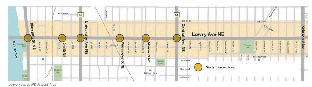
1 CPED STAFF REPORT Prepared for the City Planning Commission CPC Agenda Item #14 July 6, 2015 SMALL AREA PLAN SUMMARY Project Name: Lowry Avenue Northeast Corridor Plan and Implementation Framework Prepared By: Haila Maze, Principal Planner, (612) Wards: 1 & 3 Neighborhoods: Audubon Neighborhood Association Bottineau Neighborhood Association Holland Neighborhood Improvement Association Concerned Citizens of Marshall Terrace Windom Park Citizens in Action Existing Land Use Features: Activity Center: Central & Lowry Community Corridor: Lowry Ave NE Neighborhood Commercial Nodes: Lowry Ave NE & Marshall St NE Lowry Ave NE & University Ave NE Zoning Plate Numbers: 9, 10, & 11 BACKGROUND AND PROCESS The Lowry Avenue Northeast Corridor Plan and Implementation Framework (available on the project website) covers the Lowry Avenue NE corridor, from the bridge over the Mississippi River to the city limits. The plan focuses on bicycle and pedestrian improvements along the entire corridor, with more specific guidance for improvements and redevelopment at six key intersections along Lowry Avenue NE: Marshall Street NE 2 nd Street NE University Avenue NE Washington Street NE Monroe Street NE Central Avenue NE
2 Department of Community Planning and Economic Development This plan was developed by Hennepin County as part of the Lowry Avenue Community Works project. Lowry Avenue Community Works is County-led effort established in 1999 to improve transportation options, offer housing choice, and support business growth in the Lowry Avenue communities. Lowry Avenue Community Works is collaboration between Hennepin County Public Works, the City of Minneapolis, the Minnesota Department of Transportation, the Minneapolis Parks and Recreation Board, Metro Transit and the ten Lowry Avenue Corridor neighborhoods. The City of Minneapolis was a partner in the planning process, and is now bringing this plan through the City approval process, prior to Hennepin County action on the plan. While this does not have all the same content as a typical small area plan, it has similar standing as a policy document, and can be used in a similar way to guide development and investment. This plan updates the Lowry Avenue NE portion of the Lowry Avenue Corridor Plan, which was completed by Hennepin County in 2002 and subsequently adopted by the City Council. A portion of the 2002 plan has already been implemented, in the form of the reconstruction of Lowry Avenue North, and the replacement of the Lowry Avenue Bridge over the Mississippi River. However, the 2002 plan s recommendations for the Northeast portion have remained unimplemented to date. Moreover, significant concerns have been raised by the City and the community about the vision for the Northeast portion in that plan which included large-scale property acquisition and demolition for a road widening along the corridor. This new plan presents a different vision for Lowry Avenue NE, based on updated technical analysis and community engagement. Property acquisition is limited to at most a couple of key intersections. It proposes sidewalk and road improvements for walkers, bicyclists, transit users and drivers, and explores redevelopment options that would support business and housing growth in the area. Existing Conditions and Issues The Lowry Avenue NE corridor is currently four lanes west of Central Avenue NE and two lanes east of Central. Sidewalks are typically narrow and located at the back of curb. Obstructions in the sidewalk, including signs and utilities, mean that the pedestrian way is often very limited. Furthermore, there is a lack of room for snow storage, meaning that sidewalks and travel lanes are further narrowed in the winter months. Lowry Avenue NE is in the City s Bicycle Master Plan as a planned bicycle route. However, the limited right-of-way means that fully accommodating bicycle and pedestrian improvements to City and County standards is not possible without major property acquisition. As such, the planning process focused on how to prioritize modes for various segments of the corridor. Lowry Avenue is also a truck route, with the portion between University Avenue NE and 2 nd Street North serving as an intermodal connector between Shoreham Yards and Interstate 94. As such, the street must accommodate truck traffic. The geometry of some key intersections, particularly University Avenue, present challenges for large truck turning movements. 2
3 Department of Community Planning and Economic Development Planning Process and Community Engagement The planning process was initiated in early 2014, staffed by the County with assistance from the City. The process was guided by a Steering Team, and advised by a Community and Advisory Team and Technical Advisory Team. The teams met regularly throughout the planning process. There were also numerous public engagement activities, which incorporated artists who worked as sub-consultants to the main consultant. These including a series of public workshops, an online survey, participation in an Open Streets event, various neighborhood meetings, and outreach to Edison High School students (the school is just a short distance from Lowry and many students travel to school along the corridor). The planning process lasted about a year. The plan was drafted by late 2014, with final internal review and revisions in early Review and Approval Process Upon completion of the plan and review by County and City leadership and staff, the plan was made available for a 45-day public review April 20 to June 4, This was completed as part of the City approval process, but the comments were also provided to the County for their review. At the conclusion of the public review period, the plan was brought to the City Planning Commission Committee of the Whole (CPC COW) on June 18, 2015, to provide an overview of the plan and the public comments received. The plan was presented jointly by County and City staff. Since then, the plan has been amended to reflect comments from the 45 day review and from the CPC COW meeting. After review and action by the Minneapolis City Planning Commission on July 6, 2015, it will be jointly reviewed by both the Zoning and Planning Committee and the Transportation and Public Works Committee of City Council, prior to City Council action. Once the plan has completed the City approval process, it will be brought before the County Board of Commissioners for their review. Pending full adoption of the plan by the CPC and Council, it will be submitted subsequently to the Metropolitan Council for amendment to the Minneapolis Plan for Sustainable Growth (the City s comprehensive plan). PLAN OVERVIEW As stated above, the plan focuses on bicycle and pedestrian improvements along the length of the corridor, with more detailed guidance for six key intersections. This scope was defined by the County Commissioners, reflected previously identified priorities for improvements to Lowry Avenue NE. The plan focuses on accommodating all modes including bicycle, pedestrian, truck, transit, and parking within a limited right-of-way, in a way that supports the corridor and encourages investment and development. Some key highlights of the Lowry Avenue NE plan: Between Marshall Street NE and Central Avenue NE, the plan proposes reducing vehicle travel lanes from four lanes to three: a westbound travel lane, an eastbound travel lane and a center left-turn lane. Dropping a travel lane provides up to twelve feet in the right-of-way for pedestrian improvements, including wider sidewalks and treed boulevards. 3
4 Department of Community Planning and Economic Development Between Central Avenue NE and the City limits, the plan proposes a two vehicle travel lanes and two on-street bicycle lanes, and optional parking at selected locations. It proposes removing parking for most of this segment and reallocates this space for the bicycle lanes and wider sidewalks and boulevards. On-street parking will be included at critical areas. Streetscape improvements are proposed along the entire corridor, with some illustrations of potential improvements included. The plan clarifies that these will be partly dependent on the ability to secure funding commitments for both up-front work and ongoing maintenance. The plan proposes potential redevelopment scenarios for six key intersections identified above. These scenarios are shown as potential examples of desired development along the corridor. However, for the most part, they assume privately initiated redevelopment. The exception is some properties that are already publicly owned, or which might be assembled for limited rightof-way expansion (see next bullet). While most of the planned improvements will take place in the existing right-of-way, the plan proposes some limited acquisition at the University Avenue NE and Central Avenue NE intersections to allow for widening the road to better accommodate vehicle turn movements. This is particularly true for University Avenue NE, which has heavy truck turning movements from Shoreham Yards. The plan includes some suggested use of the remaining land left from right-of-way acquisition for redevelopment. The planning process did include some preliminary layouts and cost estimates for the infrastructure improvements. However, these are not included as part of the plan that will be adopted which focuses on the broader vision and principles. As the project moves forward, particularly once it is added to the County and City capital improvement plans, these will be further developed. While there were some preliminary timelines for implementation drafted as part of the planning process, at present there is no funding for Lowry Avenue NE in either the County or City capital improvement plans. Future action on plan recommendations will depend for the most part on identifying resources for implementation (with the possible exception of some private redevelopment opportunities). In addition to up-front capital expenditures, the enhanced streetscapes shown in the plan may need dedicated maintenance funds on an ongoing basis. COMPREHENSIVE PLAN CONSISTENCY This plan will be consistent with the following applicable policies of The Minneapolis Plan for Sustainable Growth: Land Use Policy 1.1: Establish land use regulations to achieve the highest possible development standards, enhance the environment, protect public health, support a vital mix of land uses, and promote flexible approaches to carry out the comprehensive plan Develop small area plans for designated land use features, particularly Activity Centers, Growth Centers, and Major Retail Centers, in consultation with neighborhood associations, residents, and other stakeholders. 4
5 Department of Community Planning and Economic Development Land Use Policy 1.5: Promote growth and encourage overall city vitality by directing new commercial and mixed use development to designated corridors and districts Support an appropriate mix of uses within a district or corridor with attention to surrounding uses, community needs and preferences, and availability of public facilities. Land Use Policy 1.8: Preserve the stability and diversity of the city's neighborhoods while allowing for increased density in order to attract and retain long-term residents and businesses Promote a range of housing types and residential densities, with highest density development concentrated in and along appropriate land use features. Land Use Policy 1.9: Through attention to the mix and intensity of land uses and transit service, the City will support development along Community Corridors that enhances residential livability and pedestrian access Support the continued presence of existing small-scale retail sales and commercial services along Community Corridors. Land Use Policy 1.11: Preserve and enhance a system of Neighborhood Commercial Nodes that includes a mix of housing, neighborhood-serving retail, and community uses Support the continued presence of small-scale, neighborhood-serving retail and commercial services in Neighborhood Commercial Nodes. Land Use Policy 1.12: Support Activity Centers by preserving the mix and intensity of land uses and by enhancing the design features that give each center its unique urban character Encourage mixed use buildings, with commercial uses located on the ground floor and secure entrances for residential uses. Transportation Policy 2.1: Encourage growth and reinvestment by sustaining the development of a multi-modal transportation system Continue addressing the needs of all modes of transportation, emphasizing the development of a more effective transit network. Transportation Policy 2.2: Support successful streets and communities by balancing the needs of all modes of transportation with land use policy Identify modal priorities on each street to improve the overall effectiveness of each element of the transportation network Establish and use guidelines for the design and use of streets based on both transportation function and adjoining land use Promote street and sidewalk design that balances handling traffic flow with pedestrian orientation and principles of traditional urban form. Transportation Policy 2.3: Encourage walking throughout the city by ensuring that routes are safe, comfortable, pleasant, and accessible Ensure that there are safe and accessible pedestrian routes to major destinations, including transit corridors, from nearby residential areas Identify and encourage the development of pedestrian routes within Activity Centers, Growth Centers, and other commercial areas that have superior pedestrian facilities. 5
6 Department of Community Planning and Economic Development Transportation Policy 2.5: Ensure that bicycling throughout the city is safe, comfortable and pleasant Complete a network of on- and off-street primary bicycle corridors Provide public bicycle parking facilities in major destinations such as Downtown, Activity Centers and Growth Centers. Transportation Policy 2.6: Manage the role and impact of automobiles in a multi-modal transportation system Encourage the design and completion of needed improvements to the street network, including the freeway system, which promote the efficient, safe movement of traffic. Transportation Policy 2.7: Ensure that freight movement and facilities throughout the city meet the needs of the local and regional economy while remaining sensitive to impacts on surrounding land uses Maintain a network of truck routes that ensures the safe and efficient delivery of goods to Minneapolis businesses and that directs truck traffic to a limited number of streets with appropriate weight limits. Transportation Policy 2.8: Balance the demand for parking with objectives for improving the environment for transit, walking and bicycling, while supporting the city s business community Encourage management of on-street parking in commercial areas primarily for short-term use by adjoining land uses. Housing Policy 3.1: Grow by increasing the supply of housing Support the development of new medium- and high-density housing in appropriate locations throughout the city Use planning processes and other opportunities for community engagement to build community understanding of the important role that urban density plays in stabilizing and strengthening the city. Housing Policy 3.2: Support housing density in locations that are well connected by transit, and are close to commercial, cultural and natural amenities Encourage and support housing development along commercial and community corridors, and in and near growth centers, activity centers, retail centers, transit station areas, and neighborhood commercial nodes Engage in dialogue with communities about appropriate locations for housing density, and ways to make new development compatible with existing structures and uses. Economic Development Policy 4.9: Focus economic development efforts in strategic locations for continued growth and sustained vitality Prioritize economic development efforts around designated neighborhood commercial nodes, commercial corridors, activity centers, and growth centers. Arts and Culture Policy 9.1: Integrate and utilize arts and culture as a resource for economic development Encourage the implementation of the Northeast Arts Action Plan, and the creation of cultural plans for other neighborhoods and districts Make Minneapolis a more livable place for artists through support for arts initiatives that contribute to the city s community development priorities. 6
7 Department of Community Planning and Economic Development Urban Design Policy 10.5: Support the development of multi-family residential dwellings of appropriate form and scale Smaller-scale, multi-family residential development is more appropriate along Community Corridors and Neighborhood Commercial Nodes Medium-scale, multi-family residential development is more appropriate along Commercial Corridors, Activity Centers, Transit Station Areas and Growth Centers outside of Downtown Minneapolis. Urban Design Policy 10.9: Support urban design standards that emphasize traditional urban form with pedestrian scale design features at the street level in mixed-use and transit-oriented development Encourage both mixed-use buildings and a mix of uses in separate buildings where appropriate. This plan s land use and transportation guidance is largely consistent with existing comprehensive plan guidance for the applicable land use features. The plan is also largely consistent in terms of its guidance on other topics, including housing, art, and urban design This plan overlaps with (and is for the most part is compatible with) adopted small area plans that address portions of Lowry including the Central Avenue Small Area Plan (adopted in 2008), Audubon Park Neighborhood Master Plan (2008), Above the Falls Master Plan (2013), and Holland Neighborhood Small Area Plan (2015). The Holland plan in particular identifies some additional Neighborhood Commercial Nodes, which are supported in this plan as well. There are some possible differences regarding the exact road layout at key intersections, especially at University Avenue NE. However, since these layouts are still preliminary will be refined prior to implementation, they are not seen as necessarily incompatible. FUTURE RELATED ACTIONS Implementation of the plan recommendations is part of Planning staff s 2015 work plan and will likely continue into the future. Elements of this include: Comprehensive plan changes. This plan will be incorporated into the City s comprehensive plan. This requires Metropolitan Council review for consistency with regional systems plans, in accordance with state law. As this review follows City approvals, City adoption of the plan as part of the comprehensive plan will be contingent on the pending Metropolitan Council review. This will move forward after plan adoption, possibly bundled with other pending comprehensive plan updates. Potential text amendment or rezoning. While the plan does not propose major land use changes that would necessarily impact base zoning (at least not immediately), it does suggest some potential zoning code changes. These may be accommodated through a future rezoning study again, perhaps handled jointly with other pending changes. They may also occur as part of individual land use applications which include a request for a rezoning. 7
8 Department of Community Planning and Economic Development Development review. Future development proposals for property Lowry Avenue NE corridor will require Planning Commission review of development applications such as rezonings, conditional use permits, and site plan review. In this way, the Planning Commission has a role in the incremental implementation of the plan. Environmental impact assessments and/or transportation demand management studies will be undertaken as necessary. While this plan does not include a full future land use map, it does provide some development guidance at the key intersections identified. Capital project prioritization. The capital improvements process (through the City, County, and other public entities) provides an important way to implement recommended projects in the comprehensive plan. This plan s identification of these projects provides additional priority and weight to them in project review and ranking. It also allows for proposals to be made when funding opportunities (such as grants) emerge. Many improvements along Lowry, particularly to the sidewalks and roadway, will need to be funded capital projects to advance. Redevelopment of publicly owned lands. A number of County and City owned properties are located on or near the Lowry Avenue NE corridor. Some of these have been held in anticipation of this plan s development, with the intent to use them to catalyze private development along the corridor. Since many sites are small and/or noncontiguous, more resources may be needed for additional land assembly in order to have larger scale redevelopment sites. Streetcar planning. Additional transportation and design work will be necessary for development and implementation of the plan for the Nicollet-Central Streetcar. While this only overlaps the corridor at the intersection with Central Avenue NE, it has the potential for transit benefits to the Lowry Avenue NE corridor, and connections to bus routes which run along Lowry Avenue NE. PUBLIC COMMENT A number of comments were received during the 45-day comment period from individuals, community organizations, and government staff. The compiled comments received during this time period are attached. Some common themes in the comments include: Support for the proposed pedestrian improvements, including sidewalk and boulevard expansion Concerns about maintaining or improving traffic flow on road and at key intersections, especially if number of lanes decreases Concerns about accommodating various needs if lanes decrease, including buses stopping, emergency vehicles, and snow storage Some opposition to planned widening of intersections at Central Avenue NE and University Avenue NE, with concerns regarding pedestrian accessibility 8
9 Department of Community Planning and Economic Development Interest in having more focus in the plan near Johnson Street NE, particularly with regards to pedestrian crossing and overall traffic safety Calling out removal of parking at some locations as a hardship (e.g. around Hayes and Stinson) Needed improvements to traffic signal timing at various locations Mixed feedback on lack of bicycle lane west of Central Avenue NE with some supporting and others saying bicycles should use safer alternate routes Needs for accessible (audible) signals for visually impaired, and for pedestrian countdown signals There were a number of changes and updates made to the draft plan as a result of these comments, including adding detail and clarification around topics and concepts in the plan. A table listing the comments and the responses to them is attached. RECOMMENDATIONS Recommendation of the Department of Community Planning and Economic Development: The Department of Community Planning and Economic Development recommends that the City Planning Commission and City Council approve the Lowry Avenue Northeast Corridor Plan and Implementation Framework and amend the policy guidance for the area into the City s comprehensive plan with the following conditions: The comprehensive plan amendment is subject to final review and approval by the Metropolitan Council. Additional transportation planning and design work will be necessary for development and implementation of the Nicollet-Central Streetcar. The features and recommendations of this plan will be referenced in that planning process and reevaluated in conjunction with the larger project. They may be adjusted, refined, or updated if necessary. The features and recommendations of this plan will be used to guide preparation of an updated comprehensive plan in upcoming years. As with all small area plans, features and recommendations of this plan will be reevaluated and may be adjusted or updated in the next update to the Comprehensive Plan. ATTACHMENTS Study area map and recommendations chapter Table of 45 day public comments submitted and responses Lowry Avenue Northeast Corridor Plan and Implementation Framework (online) The plan is available online at: 9
10

11 Intersection of Lowry Avenue NE and 2nd Street NE CORRIDOR PLAN RECOMMENDATIONS The Project Team was charged with creating a plan for redevelopment of the Lowry Avenue NE six study intersections; making recommendations for improving the pedestrian and biking environments; improving the streetscape with such items as pedestrian lighting; and improving the natural environment by providing stormwater treatment, storage, and retention in the corridor. This section explains the plans and designs that were created during the planning process. PEDESTRIAN AND BICYCLE IMPROVEMENTS Walking and biking are critical transportation modes in corridors such as Lowry Avenue NE and a major component of a livable community. Currently, sidewalks on Lowry Avenue NE are substandard: they are narrow, adjacent to the roadway, and obstructed by utility poles and street signs. Dedicated bicycle facilities do not currently exist, and the four-lane segment of Lowry Avenue NE is not a bikeable street for most people. Following are recommendations to promote safe and inviting pedestrian and bicycle experiences by creating or strengthening connections to nearby bicycle facilities, neighboring points of interests, shopping, the Mississippi River, trails and open spaces. Pedestrian Recommendations Provide a minimum of 6-foot-wide sidewalks (8 feet is preferred) throughout the corridor where feasible. Create boulevards to serve as a buffer from traffic, a planting space for trees, and a space to store snow. Improve intersections to provide safe and accessible areas for pedestrian and bicycle crossings. Improvements could include enhanced crosswalks, improved signalization, signage and design techniques that encourage drivers to operate at an appropriate speed. LOWRY AVENUE NE CORRIDOR PLAND AND IMPLEMENTATION FRAMEWORK 3/25/2015 DRAFT Corridor Plan Recommendations 69
12 Sidewalk bump outs are also recommended on adjacent side streets where possible to decrease crosswalk distances, moderate vehicular speeds, provide more sidewalk space, and to define on-street parking bays. Incorporate streetscape elements such as monuments, public art, kiosks and benches to create a more inviting and comfortable sidewalk environment and promote sidewalk activity. Bicycle Recommendations Install on-street bicycle lanes on Lowry Avenue NE east of Central Avenue NE. Use signs to direct Lowry Avenue NE bicycle traffic between Marshall Street NE and Central Avenue NE to and from parallel bicycle routes along 22nd Street NE, 18th Street NE and the proposed future 27th Street NE connections. Stripe bicycle lanes to the left of on-street parking provided near Central Avenue NE, Windom Park and Stinson Boulevard. Create safe and visible connections between Lowry Avenue NE and alternative bicycle routes. Provide centralized, easy to access bicycle parking (such as on-street bicycle corrals) at convenient locations for bicyclists to park their bikes and walk to places along Lowry Avenue NE. Expand the city s wayfinding system to Lowry Avenue NE and highlight access to the parallel and perpendicular bicycle routes ROADWAY SECTIONS It was necessary to look holistically at the Lowry Avenue NE public right-ofway and to study the motorized traffic to see if it was feasible to convert space currently used for travel lanes and parking to pedestrian and bicycle facilities. The Project Team developed a number of scenarios, called sections, that demonstrated how the right-of-way could be dedicated to pedestrian, bicycle and motor vehicle uses. Currently, Lowry Avenue NE is a four-lane roadway west of Central Avenue NE and two-lane roadway east of Central Avenue NE. Because of the traffic volumes, current number of lanes and different right-of-way widths between the segment east of Central Avenue NE and west of Central, the Project Team made recommendations specific to these varied roadway segments. The Team developed Sections A-C for the segment West of Central Avenue NE and Sections A-F for the segment east of Central Avenue NE. These conceptual sections can be found in Appendix F. It was determined early during the analysis phase that it was possible to convert the four-lane roadway west of Central Avenue NE to a to a three-lane segment with one eastbound lane, one westbound lane, and a continuous left-turn lane. This dropping of a travel lane provided extra space for bicycle and pedestrian improvements. As a result, all sections studied west of Central Avenue NE included the conversion of a four-lane roadway to a three-lane roadway. Some of the sections incorporated on-street parking and others removed it. The parking analysis completed in April 2014 showed parking was not heavily used on Lowry Avenue NE except for at the Central Avenue NE intersection during Friday afternoon prayer service and in the vicinity of the Fillmore intersection during Sunday morning worship service. This limited use of parking allowed for the removal of on-street parking in most sections of Lowry Avenue NE, freeing up space for bicycle and pedestrian improvements. In addition to studying parking use, the Project Team forecasted traffic needs until 2035 and the associated intersection level of service with the selected roadway and intersection improvements. The findings were that all of the key intersections will continue to operate at an acceptable overall intersection level of service (LOS) D or better during the morning and afternoon peak travel hours, assuming proposed intersection and roadway section improvements. LOS is a measure of the effectiveness of an intersection. The LOS system rates the intersection using 70 Corridor Plan Recommendations HENNEPIN COUNTY
13 the letters A through F, with A being the least congested and F being the most congested. At LOS C, roads remain safely below, but efficiently close to capacity, and posted speed is maintained. LOS D is a common design goal for urban streets during peak hours. The proposed intersection and roadway sections will be able to accommodate the forecast year 2035 Build traffic volumes. This detailed analysis is available in Appendix D. Based on stakeholder and Community and Technical Advisory Team input, the Steering Committee selected the following preferred roadway sections from the nine options that were considered. West of Central Avenue NE: Wider Sidewalks (Concept C) This recommended roadway section consists of a three-lane roadway (one 11-foot lane in each direction separated by a 12-foot center two-way left-turn lane) between Marshall Street NE and Central Avenue NE. By narrowing the existing roadway section from four lanes to the recommended three-lane section, the sidewalk and boulevard areas on each side of the roadway can be expanded to approximately 11 feet to provide a better pedestrian realm along Lowry Avenue NE to the west of Central Avenue NE. This option does not include a dedicated bicycle facility on Lowry Avenue NE and relies on parallel bicycle boulevards about a quarter mile to the north and south to accommodate through bicycle traffic. The Project Team through the community outreach effort determined that improving the pedestrian function of Lowry Avenue NE was more critical than creating dedicated bicycle facilities. Even without dedicated space, the four-to-three-lane conversion will improve the biking environment, and more people will be comfortable biking the corridor. See Figure 1 for this section. East of Central Avenue NE: Wider Sidewalks and Bicycle Facilities (Concept E). This recommended roadway section consists of a two-lane roadway with bicycle lanes (one 11-foot travel lane and one 6-foot bicycle lane in each direction), and optional parking at selected locations. This section removes parking for most of this segment of the corridor and reallocates this space to on-street bicycle lanes and wider sidewalks and boulevards. On-street parking will be included at critical areas, including the commercial area at Stinson Boulevard, Windom Park and near Central Avenue NE. See Figure 2 for this section. LOWRY AVENUE NE CORRIDOR PLAND AND IMPLEMENTATION FRAMEWORK 3/25/2015 DRAFT Corridor Plan Recommendations 71

14 Figure 14: Recommended roadway section west of Central Avenue NE 72 Corridor Plan Recommendations HENNEPIN COUNTY


15 Existing and proposed view at 3rd Street NE and Lowry Avenue NE LOWRY AVENUE NE CORRIDOR PLAND AND IMPLEMENTATION FRAMEWORK 3/25/2015 DRAFT Corridor Plan Recommendations 73


16 Existing and proposed view at Monroe Street NE and Lowry Avenue NE 74 Corridor Plan Recommendations HENNEPIN COUNTY


17 Existing and proposed view at 2nd Street NE and Lowry Avenue NE LOWRY AVENUE NE CORRIDOR PLAND AND IMPLEMENTATION FRAMEWORK 3/25/2015 DRAFT Corridor Plan Recommendations 75

18 Figure 15: Recommended roadway section west of Central Avenue NE 76 Corridor Plan Recommendations HENNEPIN COUNTY


19 Existing and proposed view near Polk Street NE and Lowry Avenue NE LOWRY AVENUE NE CORRIDOR PLAND AND IMPLEMENTATION FRAMEWORK 3/25/2015 DRAFT Corridor Plan Recommendations 77


20 Existing and proposed view near Cleveland Street NE and Lowry Avenue NE 78 Corridor Plan Recommendations HENNEPIN COUNTY

21 To convert the roadway from a four-lane section to a three-lane section, to make pedestrian safety improvements, and to accommodate truck turns, two of the six study intersections are recommended for improvements. These intersections are: Lowry Avenue NE at University Avenue NE. Lowry Avenue NE at Central Avenue NE. The reconstruction of these intersections provides an opportunity to design the intersections with bicycle and pedestrian improvements and stormwater management. Where possible, include wayfinding, pedestrian lighting, bump-outs, pedestrian countdown timers, bicycle parking, and public art in the intersection designs. The following intersection designs are in concept form only, and detailed geometrics and intersection analysis will need to be performed later. Lowry Avenue NE at Marshall Street NE Figure 16 shows the recommended intersection improvements at the Lowry Avenue NE intersection with Marshall Street NE. As shown in Figure 16, the east leg of the Lowry Avenue intersection with Marshall Street NE would be reconfigured to provide one lane of traffic in each direction on Lowry Avenue NE as well as a westbound left-turn lane. The sidewalk and boulevard on both sides of Lowry Avenue NE (east of Marshall Street) would be widened to approximately 11 feet. The radius in the northeast corner of the intersection would be increased to facilitate westbound to northbound truck movements from Lowry Avenue NE to Marshall Street NE. The proposed lane configuration on the Marshall Street NE approaches to the Lowry Avenue NE intersection would remain unchanged. Following these changes to the intersection, it would function at a level of service B during the morning peak travel time and C during the afternoon peak travel time. A description of the recommended improvements to these intersections follows. Figure 16: Recommended Improvements Lowry Avenue NE at Marshall Street NE LOWRY AVENUE NE CORRIDOR PLAND AND IMPLEMENTATION FRAMEWORK 3/25/2015 DRAFT Corridor Plan Recommendations 79

22 Lowry Avenue NE at University Avenue NE Figure 17 shows the recommended intersection improvements at the Lowry Avenue NE intersection with University Avenue NE. The alignment of Lowry Avenue NE would be shifted to the south to facilitate the trucks making the southbound to westbound right turns. The Lowry Avenue NE approaches to the intersection would be revised to provide one lane of traffic in each direction as well as westbound and eastbound left-turn lanes. The sidewalk and boulevard on both sides of Lowry Avenue NE would be widened and parking bays or bus stops will be provided in all four quadrants of the intersection with near-side bus pullouts on the Lowry Avenue NE approaches to the intersection. The corner radii, particularly in the northwest quadrant, also will be increased to facilitate truck turning movements. The proposed lane configuration on the University Avenue NE approaches to the Lowry Avenue NE intersection are recommended to remain unchanged. This intersection redesign would require the full acquisition of some parcels and partial acquisition of other parcels to provide additional roadway right-of-way. The traffic forecast to 2035 found that this intersection would function at a level of service C during both the morning and afternoon peak travel times. Figure 17: Recommended Improvements Lowry Avenue NE at University Avenue NE 80 Corridor Plan Recommendations HENNEPIN COUNTY

23 Lowry Avenue NE at Central Avenue NE Figure 18 shows the recommended intersection improvements at the Lowry Avenue NE intersection with Central Avenue NE. As shown, the alignment of Lowry Avenue NE would be shifted slightly to the north on the west side of Central Avenue NE and slightly to the south on the east side. The Lowry Avenue NE approaches to the intersection would be revised to provide one lane of traffic in each direction as well as left-turn lanes at the Central Avenue NE intersection. The sidewalk and boulevard area on both sides of Lowry Avenue NE would be widened, a parking bay would be provided in the southeast quadrant, and far side bus pull-outs would be provided on Lowry Avenue NE. The corner radii in three of the four quadrants, would also be increased to facilitate truck turning movements. The proposed lane configuration on the Central Avenue NE approaches to the Lowry Avenue NE intersection would remain unchanged. The traffic forecast to 2035 finds that this intersection would function at a level of service C during the morning and afternoon peak travel times following reconstruction. Safety will be improved at the Lowry Avenue NE intersection with Central Avenue NE with the addition of left-turn lanes on the west- and eastbound Lowry Avenue NE approaches to the intersection. The proposed left-turn lanes on Lowry Avenue NE will remove left-turning vehicles from through traffic, thus reducing conflicts. The proposed center left-turn lanes on Lowry Avenue NE will also improve safety by improving sight distance for left-turn turning vehicles. Figure 18: Recommended Improvements Lowry Avenue NE at Central Avenue NE LOWRY AVENUE NE CORRIDOR PLAND AND IMPLEMENTATION FRAMEWORK 3/25/2015 DRAFT Corridor Plan Recommendations 81
24 INTERSECTION DEVELOPMENT SCENARIOS Six nodes on Lowry Avenue NE were identified for this planning study intersections with Marshall Street NE, 2nd Street NE, University Avenue NE, Washington Street NE, Monroe Street NE and Central Avenue NE. These intersections were analyzed for redevelopment opportunities, bicycle and pedestrian safety improvements and enhancements to traffic flow. The transportation improvements to these intersections were previously presented in earlier segments of this plan. This section describes the redevelopment scenarios identified for each of the six study intersections. All scenarios are thought to be long term taking up to 20 years to see the recommended changes. Whether the scenarios are pursued is dependent on the ability to purchase land from willing sellers. A recommendation of the 2002 Lowry Avenue Corridor Plan was the consolidation of existing services, retail and office space around transit-served intersections to create intensified mixed-use, transit-friendly developments at primary intersections. It also envisioned that the obsolete commercial uses interspersed among residential areas of the corridor would eventually relocate to the transitfriendly new developments. These recommendations remain applicable to Lowry Avenue NE today and play out in the scenarios presented within this section of the plan. The market study completed as a part of this planning process evaluated the six study intersections for their potential to support new development. The market assessment found the following strengths and challenges to creating new housing, retail, and offices along Lowry Avenue NE. Corridor-wide Development Strengths Strong forecasted growth. Strengthening of favorable demographics. Proximity to Mississippi River. Transit access. Proximity to downtown. Development momentum. Eclectic stock of buildings. Relatively low property valuation. Corridor-wide Development Challenges Predominance of small, shallow lots. Site assembly. Incompatible uses. Incompatible zoning. Limited parking opportunities. Traffic volumes at certain intersections. Narrow sidewalks. Lack of space to accommodate people biking The matrix on the following page lists the probable developer interest for each study node for the three feasible land uses of retail, office, and housing. 82 Corridor Plan Recommendations HENNEPIN COUNTY

25 PROBABLE DEVELOPER INTEREST Plan new construction in relation to the surrounding buildings. Using common elements from the façade and architecture of neighboring buildings will create a harmonious feel to the streetscape. Building size, height and materials all factor into a coherent sense of place. Encourage the reuse of buildings where possible rather than new construction. Incorporate existing historical or character enhancing elements into redevelopment. Design the first level to have a human scale with attention to items including the building entries, first floor storefronts, lighting, signage and windows. Highlight major building entries. Create a sense of security by having building windows look onto the street. Private investment in the corridor can be spurred by an attractive destination with a strong sense of place, human scale, architectural cohesion and vibrant neighborhoods. Scale, character, massing and ethos of the corridor s buildings contribute significantly to these elements. A project initiative is to promote sustainable design excellence in new development so that new buildings architecturally fit into the surroundings, are energy and water efficient, and respond to neighborhood transitions with building massing. Specific recommendations for development follow. Redevelopment recommendations: Create mixed-use, multi-story buildings with first floor uses that activate the street. Positively relate new construction to the street with building elements yet not infringe on the streetscape. Appropriate building setbacks will depend on building use. Consider a building setback from the sidewalk to provide a broader area for pedestrian activities. Where existing sidewalks are less than 10 feet wide, set buildings back a minimum of four feet (within the frontage zone) to create wider sidewalks for outdoor seating and streetscape elements. Create and adhere to guidelines and standards for site design, building massing, façade treatments, building materials, signs and sustainable design practices. Reserve space for stormwater retention or detention needs, and bicycle circulation. Treat one-inch rainfall events on site by, for example, infiltrating rainwater in ponds, swales and rain gardens or storing it for reuse in cisterns. Use permeable pavers to infiltrate water in parking lots. Screen at-grade parking lots with vegetation such as hedges and trees. Consider these parking lot screens as potential zones for stormwater treatment and infiltration. Use LED or other energy-efficient lighting. Consider solar-powered LED lighting to light exterior spaces. Provide space for organics composting and, for residential uses, on-site or nearby gardening. Incorporate bicycle parking and facilities into the first floor. Encourage constructing and renovating buildings to meet Leadership in Energy & Environmental Design (LEED) certification standards of silver or better. LOWRY AVENUE NE CORRIDOR PLAND AND IMPLEMENTATION FRAMEWORK 3/25/2015 DRAFT Corridor Plan Recommendations 83
26 REDEVELOPMENT CONCEPTS LOWRY AVENUE NE AND MARSHALL STREET NE This node presents a great opportunity to create a mixed-use node by providing additional housing choices, restaurants and businesses that serve surrounding residential neighborhoods. The roadway intersection improvements are minimal at this location and do not require building removal. As a result, any redevelopment at this location will be driven by the private sector and some development is underway. As of 2014, Betty Danger s Country Club restaurant and bar is being built in the northeast quadrant of this intersection. The owner of the southeast quadrant of the intersection is considering redevelopment of the property owned at this location, which includes most properties between Marshall Street NE and Grand Street NE and three singlefamily properties along Marshall Street NE. The single family homes are zoned R2B with the remaining parcels zoned C2. Rezoning of the entire site would be required to accommodate the proposed development. This plan recommends a four-story mixed-use building (labeled A) with 12,000 square feet of commercial space on the first floor, approximately 34 to 38 units on three upper floors, one level of underground parking with 32 stalls and approximately 70 surface parking stalls behind the building. Parking could be shared with adjacent commercial uses off peak. The current building at the intersection of Lowry Avenue NE and Grand Street NE is proposed to remain. Note: Drawing does not illustrate this. To the west of this existing building is proposed a new two-story commercial building (labeled B) with 2,300 square feet commercial /restaurant space on the first floor and a second floor with office or residential uses. Parking for the building would be behind the building in a surface parking lot of with about 28 stalls. It is recommended that a minimum of 12 feet is dedicated to sidewalks and boulevard space along the south side of Lowry Avenue NE adjacent to the proposed redevelopment. 84 Corridor Plan Recommendations HENNEPIN COUNTY

27 LEGEND Commercial / Retail Mixed Use Residential Lowry Avenue NE A B Parking Proposed Redevelopment at Lowry Avenue NE and Marshall Street NE Intersection LOWRY AVENUE NE CORRIDOR PLAND AND IMPLEMENTATION FRAMEWORK 3/25/2015 DRAFT Corridor Plan Recommendations 85


28 Marshall Street NE Lowry Avenue NE Existing View Bird s-eye View of proposed redevelopment at Lowry Avenue NE and Marshall Street NE intersection 86 Corridor Plan Recommendations HENNEPIN COUNTY
29 LOWRY AVENUE NE AND UNIVERSITY AVENUE NE This node has the greatest opportunity to evolve into a mixed-use urban village providing more housing choices, restaurants and businesses that serve the neighborhoods. The roadway is proposed to shift south to gain additional rightof-way needed to make the intersection improvements, including on-street parking and bus pull-offs. While detailed roadway design is not complete, initial conceptual design shows that additional right-of-way may be needed from approximately 9 parcels. Preliminary analysis identified the need to relocate the restaurant occupants in the southwest quadrant of the intersection and the smoke shop in the southeast quadrant of the intersection. The southeast corner of the intersection is currently an automotive use zoned C2. It is recommended this area redevelop as a mix of commercial and office in a two-story building (labeled C). Approximately 60 parking stalls could be installed behind the building. This parking should be buffered from the adjacent residential properties with at least a 10-foot buffer planting strip that could also manage stormwater. The northwest corner of the intersection is currently a smoke shop zoned C2. Consider redeveloping this site with a two-story commercial/office mixed-use building with approximately 10,000 square feet per floor and a 44-stall surface parking lot behind the building. A 10-foot wide planting strip would buffer the parking lot from adjacent residential properties and facilitate stormwater management. It is recommended that a minimum of 12 feet is dedicated to sidewalks and boulevard space along the south side of Lowry Avenue NE adjacent to the proposed redevelopment sites. Buses will use a dedicated pull-off space at this intersection in parking bays. Onstreet parking at this location will be limited to six stalls as a result. This block could also support a new residential building (labeled D). This site is currently zoned R-4 and could accommodate approximately 24 units in a threestory building. Parking could be underground with 22 stalls and in a surface lot that is shared with the adjacent commercial uses. The southwest corner of the intersection is currently a restaurant zoned C1. This site is recommended to be redeveloped with four-story mixed-use buildings (labeled D) with first-floor commercial occupying 9,800 square feet. The existing restaurant should consider relocating into this first-floor space. Approximately 32 residential units could be located on the three upper floors. Parking would be provided with one level of underground parking with 30 stalls and approximately 60 surface parking stalls behind the building that could be shared with adjacent commercial uses. LOWRY AVENUE NE CORRIDOR PLAND AND IMPLEMENTATION FRAMEWORK 3/25/2015 DRAFT Corridor Plan Recommendations 87


30 LEGEND Commercial / Retail Mixed Use Residential Lowry Avenue NE Stanley s A LEGEND Commercial / Retail Mixed Use Residential Parking B C D Parking Proposed redevelopment at Lowry and University Avenue intersection 88 Corridor Plan Recommendations HENNEPIN COUNTY


31 University Avenue NE Lowry Avenue NE Existing View Bird s-eye View of proposed redevelopment at Lowry and University Avenue intersection LOWRY AVENUE NE CORRIDOR PLAND AND IMPLEMENTATION FRAMEWORK 3/25/2015 DRAFT Corridor Plan Recommendations 89
32 LOWRY AVENUE NE AND CENTRAL AVENUE NE Lowry Avenue NE and Central Avenue NE intersection also will undergo a transformation. The new recommended roadway section shifts the road into the northwest quadrant of the intersection west of Central Avenue NE and into the southeast quadrant of the intersection east of Central Avenue NE. These shifts will require the acquisition of land in both quadrants. The southeast corner of the intersection, commonly referred to as the fire site, provides a unique opportunity to create a significant mixed use development providing more housing choices, restaurants, businesses and shared parking that will serve Central Avenue NE and adjacent neighborhoods. This potential development will maximize the currently underdeveloped parcels, remove blighted parcels, and increase the tax base while preserving the residential character. The current zoning is C1 near Central Avenue NE and R5 near Polk Street NE. redeveloped with a 9,000 square foot commercial and office mixed use building (labeled A) or the adjacent commercial building to the north should expand onto this parcel. The current zoning is C1. New surface parking with six stalls can be provided behind the buildings. A minimum 10-foot-wide buffer planting strip should be installed between the parking lot and adjacent residential properties. This buffer strip could also facilitate stormwater management. It is recommended that a minimum of 12 feet is dedicated to sidewalks and boulevard space along the southeast and northwest quadrants of the intersection adjacent to the proposed redevelopment sites. Bus pull-off spaces will be provided along Lowry Avenue NE west of Central Avenue NE. Three buildings are proposed within this block: Two-story, 3,000-square-foot commercial building along Central Avenue (labeled B). Four-story mixed-use building (labeled C) with first-floor commercial/office space occupying 26,000 square feet and approximately 72 units on three upper floors. One level of underground parking could accommodate 65 stalls. Fourstory residential building (labeled D) with approximately 80 units and one level of underground parking with 70 stalls. Proposed four-story residential building (labeled D) with approximately 80 units and one level of underground parking with 70 stalls. Parking for the above buildings and the larger commercial area is proposed to be provided in a two-story structured parking deck with approximately 160 parking stalls in the middle of the mixed-use development. The proposed roadway improvements will require the purchase of a parcel currently occupied by a linen store in the northwest quadrant of the intersection. A portion of this acquired property will remain following the reconstruction of the intersection, offering an opportunity to develop the site. This parcel should be 90 Corridor Plan Recommendations HENNEPIN COUNTY


33 A Lowry Avenue NE B C Parking Ramp D LEGEND Commercial / Retail Mixed Use Residential Proposed redevelopment at Lowry Avenue NE and Central Avenue NE intersection LOWRY AVENUE NE CORRIDOR PLAND AND IMPLEMENTATION FRAMEWORK 3/25/2015 DRAFT Corridor Plan Recommendations 91


34 Lowry Avenue NE Central Avenue NE Existing View Bird s-eye View of proposed redevelopment at Lowry Avenue NE and Central Avenue NE intersection 92 Corridor Plan Recommendations HENNEPIN COUNTY
 and southeast (zoned R1-A and C1) quadrants of the intersection.")


35 LOWRY AVENUE NE AND WASHINGTON STREET NE The short-term redevelopment strategy for the Lowry Avenue NE and Washington Street NE intersection is to replace single-family homes in poor condition on the northwest (zoned R-1A) and southeast (zoned R1-A and C1) quadrants of the intersection. The single family homes should be replaced with 12 rowhomes that reinforce the character and image of the corridor. Long-term redevelopment strategies for this intersection can be found in Appendix G. LEGEND Commercial / Retail LOWRY AVENUE NE AND MONROE STREET NE The short-term redevelopment strategy for the Lowry Avenue NE and Monroe Street NE intersection is to remove outdated buildings to increase the tax base while preserving the residential character to the north. The northwest corner of the intersection is zoned C-1 and the northeast corner of the intersection is zoned R2B. The northwest corner of the intersection is proposed to be redeveloped with a commercial building. A new transit shelter and plaza to serve transit riders, particularly the Edison High School students, should be a part of this development. The northeast corner shows seven new townhomes. In the southeast corner, the gas station and Dairy Queen remain in this concept. A new location for the gas station building is being shown farther south on the current site. Driveways for all three of these businesses could be consolidated and parking could be shared between the businesses. Mixed Use Residential Existing to Remain Existing to Remain DQ Proposed redevelopment at Lowry Avenue NE and Washington Street NE intersection Proposed redevelopment at Lowry Avenue NE and Monroe Street NE intersection LOWRY AVENUE NE CORRIDOR PLAND AND IMPLEMENTATION FRAMEWORK 3/25/2015 DRAFT Corridor Plan Recommendations 93

 with 26,000 square feet of commercial or office space on")
36 LOWRY Avenue NE AND 2ND STREET NE INTERSECTION Buildings currently occupy all four corners of the intersection. The buildings vary in condition and use. The northwest corner is zoned I-2, the northeast corner is zoned C-2, the southeast corner is zoned C-1 and R-3 and the southwest corner is zoned C-2. The proposed short-term redevelopment consists of three new buildings. LEGEND Commercial / Retail Mixed Use Residential In the northwest quadrant of the intersection is a four- story mixed-use building (labeled A) with 26,000 square feet of commercial or office space on the first floor, 40 units of housing on the upper floors, 46 stalls of parking in one level of underground parking and approximately 58 stalls of surface parking behind the building. The surface parking could be shared with surrounding commercial uses. A three-story mixed-use building (labeled B) with 9,200 square foot of first floor commercial/office space is proposed for the southwest quadrant of the intersection. It would include 18 units of housing on the upper floors and 40 surface parking stalls to the rear. Lowry Avenue NE B A Existing to Remain Town Hall Brewery C A two story building with 9,000 square feet commercial/office space (labeled C) is proposed for the southeast quadrant of the intersection, with 32 stalls of surface parking behind the building. 2nd Street NE 94 Corridor Plan Recommendations HENNEPIN COUNTY
Exhibit 1 PLANNING COMMISSION AGENDA ITEM
 Exhibit 1 PLANNING COMMISSION AGENDA ITEM Project Name: Grand Junction Circulation Plan Grand Junction Complete Streets Policy Applicant: City of Grand Junction Representative: David Thornton Address:
CITY OF BLOOMINGTON COMPLETE STREETS POLICY
 CITY OF BLOOMINGTON COMPLETE STREETS POLICY POLICY OBJECTIVE: The City of Bloomington will enhance safety, mobility, accessibility and convenience for transportation network users of all ages and abilities,
Ann Arbor Downtown Street Plan
 1 Ann Arbor Downtown Street Plan Public Workshop #1 We know that. 2 Public right-of-way (streets, sidewalks, and alleys) make up 30% of the total District area of downtown. Streets need to provide mobility
Proposed. City of Grand Junction Complete Streets Policy. Exhibit 10
 Proposed City of Grand Junction Complete Streets Policy Exhibit 10 1 City of Grand Junction Complete Streets Policy Vision: The Complete Streets Vision is to develop a safe, efficient, and reliable travel
CONNECTING PEOPLE TO PLACES
 CONNECTING PEOPLE TO PLACES 82 EAST BENCH MASTER PLAN 07 Introduction The East Bench transportation system is a collection of slow moving, treelined residential streets and major arteries that are the
STONY PLAIN ROAD STREETSCAPE
 Jasper Place Revitalization Strategy: Vision The people involved in the Jasper Place Revitalization Strategy envision: Goal 1: Feeling safe in our community Create a community where feeling safe is common--where
Tonight is for you. Learn everything you can. Share all your ideas.
 Strathcona Neighbourhood Renewal Draft Concept Design Tonight is for you. Learn everything you can. Share all your ideas. What is Neighbourhood Renewal? Creating a design with you for your neighbourhood.
HARRISON STREET/OAKLAND AVENUE COMMUNITY TRANSPORTATION PLAN
 HARRISON STREET/OAKLAND AVENUE Community Workshop #4: Draft Plan Review December 3, 2009 D E S I G N, C O M M U N I T Y & E N V I R O N M E N T INTRODUCTIONS Key Project Staff: Alisa Shen, Project Manager,
Executive Summary Route 30 Corridor Master Plan
 Route Corridor Master Plan Project Overview The Route Corridor Master Plan is a coordinated multimodal transportation and land use plan for the entire stretch of Route through East Whiteland Township,
Environment and Public Works Committee Presentation
 Mixed Use Centers Complete Streets Guidelines Project Environment and Public Works Committee Presentation December 10, 2008 Project Objectives: Conduct an inter-departmental and agency process to study
Vision: Traditional hamlet with an attractive business/pedestrian friendly main street connected to adjacent walkable neighborhoods
 N D. Focus Area II Vision: Traditional hamlet with an attractive business/pedestrian friendly main street connected to adjacent walkable neighborhoods Transit Road Focus Area II is located in the Hamlet
Omaha s Complete Streets Policy
 Omaha s Complete Streets Policy (Adopted August 2015) VISION To create great places and enhance our quality of life, the City of Omaha will provide safe, accessible streets for all users. Complete Streets
Agenda. Overview PRINCE GEORGE S PLAZA METRO AREA PEDESTRIAN PLAN
 PRINCE GEORGE S PLAZA METRO AREA PEDESTRIAN PLAN May 28, 2008 Agenda Welcome and introductions Project overview and issue identification Planning context and strengths Design challenges and initial recommendations
Transportation Master Plan Advisory Task Force
 Transportation Master Plan Advisory Task Force Network Alternatives & Phasing Strategy February 2016 BACKGROUND Table of Contents BACKGROUND Purpose & Introduction 2 Linking the TMP to Key Council Approved
A CHANGING CITY. of Edmonton, it is essential that it reflects the long-term vision of the City.
 A CHANGING CITY By the year 2040, Edmonton will be home to more than 1 million people. To accommodate growth and support a healthy and compact city, we need a new approach to development/redevelopment
summary of issues and opportunities
 1 summary of issues and opportunities EXECUTIVE SUMMARY CHAPTER 2: HISTORY - 3: LAND USE This first chapter is an overview of lessons learned from analysis of the existing conditions on El Camino as well
Corpus Christi Metropolitan Transportation Plan Fiscal Year Introduction:
 Introduction: The Safe, Accountable, Flexible, Efficient Transportation Equity Act: A Legacy for Users (SAFETEA-LU) has continued the efforts started through the Intermodal Surface Transportation Efficiency
Bicycle and Pedestrian Advisory Committee (BPAC) November 21, 2013
 November 21, 2013") Bicycle and Pedestrian Advisory Committee (BPAC) November 21, 2013 OVERALL LAND USE CONCEPT Overall Broadway Valdez District: 95.5 acres (35.1 acres right-of ways + 60.4 acres developable land) Plan Subareas:
Bicycle and Pedestrian Advisory Committee (BPAC) November 21, 2013 OVERALL LAND USE CONCEPT Overall Broadway Valdez District: 95.5 acres (35.1 acres right-of ways + 60.4 acres developable land) Plan Subareas:
Arterial Transitway Corridors Study. Ave
 Arterial Transitway Corridors Study Ave January 2012 Arterial Transitway Corridors Study Overview Corridor Features and Demographics 11 study corridors, 95 route miles 86,000 daily rides and half of existing
Comments EXECUTIVE SUMMARY
 Comments 1. Under any Alternatives, MCDOT should provide better at-grade pedestrian crossing of Georgia Avenue and Forest Glen Road, including improved crosswalks with wider medians and adequate signal
University of Victoria Campus Cycling Plan Terms of Reference. 1.0 Project Description
 University of Victoria Campus Cycling Plan Terms of Reference 1.0 Project Description The Campus Cycling Plan, a first for the University, will provide a comprehensive and coordinated approach to support
Chapter 7. Transportation. Transportation Road Network Plan Transit Cyclists Pedestrians Multi-Use and Equestrian Trails
 Chapter 7 Transportation Transportation Road Network Plan Transit Cyclists Pedestrians Multi-Use and Equestrian Trails 7.1 TRANSPORTATION BACKGROUND The District of Maple Ridge faces a number of unique
Public Workshop #2. September 14, 2016
 Public Workshop #2 September 14, 2016 Agenda Welcome Project Overview Where We Have Been Alternatives for State Street Land Use Street Design Next Steps 2 Project Overview Create a Vibrant State Street
PRINCE GEORGE S PLAZA METRO AREA PEDESTRIAN PLAN
 PRINCE GEORGE S PLAZA METRO AREA PEDESTRIAN PLAN May 28, 2008 Agenda Welcome and introductions Project overview and issue identification Planning context and strengths Design challenges and initial recommendations
City of Seattle Edward B. Murray, Mayor
 City of Seattle Edward B. Murray, Mayor Department of Transportation Scott Kubly, Director Eastlake Community Council 117 E Louisa St. #1 Seattle, WA 98102-3278 January 28, 2016 RE: Roosevelt to Downtown
Item to be Addressed Checklist Consideration YES NO N/A Required Description Complete Streets Guidelines
 Passaic County Complete Streets Checklist - Concept Development Project Name Item to be Addressed Checklist Consideration YES NO N/A Required Description Complete Streets Guidelines Existing Plans Have
Main-McVay Transit Study: Phase 2 Options Definition and High Level Constraints Evaluation
 Main-McVay Transit Study: Phase 2 Options Definition and High Level Constraints Evaluation APRIL 2016 A collaborative study between: For Additional Information or to Comment If you would like additional
TRAVEL PLAN: CENTRAL EUROPEAN UNIVERSITY CAMPUS REDEVELOPMENT PROJECT TRAVEL PLAN. Central European University Campus Redevelopment Project.
 TRAVEL PLAN Central European University Campus Redevelopment Project Page 1 Table of Contents Introduction... 3 Background... 7 Building Users... 7 Transportation in Community Consultation... 7 Summary
REGIONAL BICYCLE AND PEDESTRIAN DESIGN GUIDELINES
 REGIONAL BICYCLE AND PEDESTRIAN DESIGN GUIDELINES November 16, 2011 Deb Humphreys North Central Texas Council of Governments Bicycle and Pedestrian Advisory Committee Snapshot of the Guide 1. Introduction
City of Wilsonville 5 th Street to Kinsman Road Extension Project
 City of Wilsonville 5 th Street to Kinsman Road Walking Tour & Neighborhood Workshop Summary Report Public Outreach Overview On July 18 th, 2017, the City of Wilsonville hosted a neighborhood walking tour
APPENDIX A: Complete Streets Checklist DRAFT NOVEMBER 2016
 APPENDIX A: Complete Streets Checklist DRAFT NOVEMBER 2016 Complete Streets Checklist MetroPlan Orlando s Complete Streets Checklist is an internal planning tool for staff to further implementation of
Make Lincoln Highway an economically vibrant corridor that is safe, efficient, and beautiful for local residents and visitors.
 Lincoln Highway Streetscape Plan Stakeholder Workshop #2 Handout Contents Introduction and Project Vision Planning Principles Specific Recommendations including a Proposed Typical Roadway Section Renderings
2014/2015 BIKE ROUTE PLAN 83 AVENUE PROTECTED BIKE LANE
 About the Project 2014/2015 BIKE ROUTE PLAN The City of Edmonton is planning a major bike route on the south side of Edmonton. This bike route is one part of a plan to provide citizens with transportation
Living Streets Policy
 Living Streets Policy Introduction Living streets balance the needs of motorists, bicyclists, pedestrians and transit riders in ways that promote safety and convenience, enhance community identity, create
CITY OF COCOA BEACH 2025 COMPREHENSIVE PLAN. Section VIII Mobility Element Goals, Objectives, and Policies
 CITY OF COCOA BEACH 2025 COMPREHENSIVE PLAN Section VIII Mobility Element Goals, Objectives, and Policies Adopted August 6, 2015 by Ordinance No. 1591 VIII MOBILITY ELEMENT Table of Contents Page Number
Southview Blvd & 3 rd Avenue Improvement Project. Public Open House December 4, to 7pm
 Southview Blvd & 3 rd Avenue Improvement Project Public Open House December 4, 2014 5 to 7pm Southview Blvd & 3 rd Avenue Public Information Meeting Agenda Presentation 5:30 to 6:15 pm Purpose of Project
5 CIRCULATION AND STREET DESIGN
 5 CIRCULATION AND STREET DESIGN This chapter describes circulation and streetscape improvements proposed for the Northwest Chico Specific Plan Area. It includes detailed design specifications for existing
City of Novi Non-Motorized Master Plan 2011 Executive Summary
 City of Novi Non-Motorized Master Plan 2011 Executive Summary Prepared by: February 28, 2011 Why Plan? Encouraging healthy, active lifestyles through pathway and sidewalk connectivity has been a focus
5. RUNNINGWAY GUIDELINES
 5. RUNNINGWAY GUIDELINES These guidelines should be considered collectively when making runningway decisions. A runningway is the linear component of the transit system that forms the right-of-way reserved
Complete Streets. Designing Streets for Everyone. Sarnia
 Complete Streets Designing Streets for Everyone Sarnia Complete Streets ~ Sarnia ~ 2018 Introduction Our City is made up of a network of streets that we use to go for a walk, cycle to work, drive to the
APPENDIX G: INTERSECTION NEEDS AT OKEECHOBEE BOULEVARD
 APPENDIX G: INTERSECTION NEEDS AT OKEECHOBEE BOULEVARD INTERSECTION NEEDS AT SR 7 and OKEECHOBEE BOULEVARD SR 7 Extension Project Development and Environment (PD&E) Study From Okeechobee Boulevard (SR
TRANSPORTATION COMMISSION Agenda Staff Report
 TRANSPORTATION COMMISSION Agenda Staff Report Agenda Item No. 5.a DATE: JULY 31, 2014 TO: FROM: SUBJECT: TRANSPORTATION COMMISSION COMMUNITY DEVELOPMENT DEPARTMENT - PLANNING DRAFT OLYMPIC CORRIDOR PREFERRED
PEDESTRIAN ACTION PLAN
 ATTACHMENT 2 CITY OF SANTA MONICA PEDESTRIAN ACTION PLAN CITY OF SANTA MONICA PEDESTRIAN ACTION PLAN This page intentionally left blank EXECUTIVE SUMMARY CHAPTER 1 EXECUTIVE SUMMARY Setting the Stage
Hennepin County Bicycle and Pedestrian Planning
 Hennepin County Bicycle and Pedestrian Planning 1 Value of bicycle and sidewalk systems Safety Livability Mobility Health Personal Finances Economic Sustainability Clean Air Recreation Parking and congestion
MAG Town of Cave Creek Bike Study Task 6 Executive Summary and Regional Significance Report
 Page 1 MAG Town of Cave Creek Bike Study Task 6 Executive Summary and Regional Significance Report August 1, 2012 MAG Project #481 Page 2 Task 6 Executive Summary and Regional Significance Report Introduction
EXECUTIVE SUMMARY. Vision
 Vision Walking and bicycling in Salt Lake City will be safe, convenient, comfortable, and viable transportation options that connect people to places, foster recreational and economic development opportunities,
East Burke Transportation, Safety and Capacity Improvements
 East Burke Transportation, Safety and Capacity Improvements The purpose of this project is to increase mobility and improve safety for pedestrians, cyclists, and motor vehicles along VT Route 114 in the
Lincoln Neighborhood Corridor Plan The LiNC
 CITY OF SANTA MONICA Lincoln Neighborhood Corridor Plan The LiNC PLANNING COMMISSION September 2, 2015 COMMUNITY DESIGN + ARCHITECTURE TEAM: Community Design + Architecture Iteris Studio 111 Urban Place
Circulation in Elk Grove includes: Motor vehicles, including cars and trucks
 Circulation, as it is used in this General Plan, refers to the many ways people and goods move from place to place in Elk Grove and the region. Circulation in Elk Grove includes: Motor vehicles, including
Solana Beach Comprehensive Active Transportation Strategy (CATS)
") Solana Beach Comprehensive Active Transportation Strategy (CATS) 3.0 Goals & Policies The Solana Beach CATS goals and objectives outlined below were largely drawn from the Solana Beach Circulation Element
Solana Beach Comprehensive Active Transportation Strategy (CATS) 3.0 Goals & Policies The Solana Beach CATS goals and objectives outlined below were largely drawn from the Solana Beach Circulation Element
Chapter 5 Future Transportation
 Chapter 5 Future Transportation The Future Land Use Plan identifies the desired land use designations. The land uses desired for Crozet depend, in large part, on the success of the transportation system,
Moving Cambridge. City of Cambridge Transportation Master Plan Public Consultation Centre. March 7, :00 8:00 PM.
 City of Cambridge Transportation Master Plan Public Consultation Centre March 7, 2018 5:00 8:00 PM Region of Waterloo City of Cambridge Transportation Master Plan Public Consultation Centre March 7, 2018
RESOLUTION NO ?? A RESOLUTION OF THE CITY OF NEPTUNE BEACH ADOPTING A COMPLETE STREETS POLICY
 RESOLUTION NO. 2018-?? A RESOLUTION OF THE CITY OF NEPTUNE BEACH ADOPTING A COMPLETE STREETS POLICY WHEREAS, safe, convenient, and accessible transportation for all users is a priority of the City of Neptune
WHEREAS delivery trucks also pass through the Narrows, into the northern parking lot, to loading docks in the back of the building.
 CEDAR-ISLES-DEAN NEIGHBORHOOD ASSOCIATION ( CIDNA ) RESOLUTION OPPOSING A DRUG STORE DRIVE THRU, AND COMMENDING DORAN COMPANIES FOR PROPOSING MITIGATING AMENITIES INCLUDING NEW LANDSCAPING AND A DEDICATED
RZC Appendix 8A Marymoor Subarea Street Requirements
 RZC Appendix 8A Marymoor Subarea Street Requirements For additional design details for Marymoor Subarea infrastructure, refer to the 2017 Marymoor Subarea Infrastructure Planning Report. STREET REQUIREMENTS
Table #6 VISION CHARACTERISTICS
 Table #6 VISION White Flint is a place to live, work, play, shop, and walk with sufficient density to encourage quality redevelopment. Vibrant streets and consistent streetscapes are important. CHARACTERISTICS
NEWMARKET UPHAM S CORNER
 SOUTH STATION Planning Initiative NEWMARKET UPHAM S CORNER COLUMBIA ROAD (P) FOUR CORNERS/GENEVA Working Advisory Group (WAG) Meeting #5 TALBOT AVENUE MORTON STREET BLUE HILL AVE/CUMMINS HWY (P) RIVER
SANTA MONICA BOULEVARD CORRIDOR
 CIRCULATION ELEMENT WHITE PAPER NO. 3 SANTA MONICA BOULEVARD CORRIDOR INTRODUCTION From the 1930s to the beginning of Los Angeles freeway era, Santa Monica Boulevard, (previously Route 66, the Beverly
City of Gainesville Transportation/Roadway Needs PROJECT SUMMARY
 A1 Roadway Resurfacing $23,846,000 TYPE: Preservation of existing system Roadway resurfacing A2 Signal Replacement $6,000,000 TYPE: Preservation of existing system Replace traffic signals. B1 W 6th St
CONNECTIVITY PLAN. Adopted December 5, 2017 City of Virginia Beach
 CONNECTIVITY PLAN Adopted December 5, 2017 City of Virginia Beach CONTENTS 1.0 Background & Purpose... 2 2.0 Existing Inventory & Analysis... 3 ViBe District Existing Walking Conditions... 4 3.0 ViBe District
North Shore Transportation Improvement Strategy
 North Shore Transportation Improvement Strategy Preliminary, Near-term Recommendation 2016 April Transportation Improvement Strategy (TIS) Comprehensive and Analytical A multi-modal transportation strategy
Chapter 3: Multi-Modal Circulation and Streetscapes
 CHAPTER 3: MULTI-MODAL CIRCULATION AND STREETSCAPES Chapter 3: Multi-Modal Circulation and Streetscapes Overview Streetscape improvements have already been completed for Depot Street between Main Avenue
C C C
 C-012-001 Thank you for your support for the creation of new public space and nonmotorized access between downtown and the waterfront through the Overlook Walk, the East-West Connections, and the Promenade.
In station areas, new pedestrian links can increase network connectivity and provide direct access to stations.
 The Last Mile Planning for Pedestrians Planning around stations will put pedestrians first. Making walking to stations safe and easy is important; walking will be a part of every rapid transit Accessible
APPENDIX 2 LAKESHORE ROAD TRANSPORTATION REVIEW STUDY EXECUTIVE SUMMARY
 APPENDIX 2 LAKESHORE ROAD TRANSPORTATION REVIEW STUDY EXECUTIVE SUMMARY Appendix 2 City of Mississauga Lakeshore Road FINAL REPORT Transportation Review Study December 2010 EXECUTIVE SUMMARY Study Purpose
Working Group Meeting
 Working Group Meeting February 6, 2018 Parks and Natural Resources Operations Building Transportation Analysis Draft Policy Framework Agenda 7:05 pm Welcome 7:10 pm Follow-up from Previous Meetings Schedule
Basalt Creek Transportation Refinement Plan Recommendations
 Basalt Creek Transportation Refinement Plan Recommendations Introduction The Basalt Creek transportation planning effort analyzed future transportation conditions and evaluated alternative strategies for
Chapter 2: Standards for Access, Non-Motorized, and Transit
 Standards for Access, Non-Motorized, and Transit Chapter 2: Standards for Access, Non-Motorized, and Transit The Washtenaw County Access Management Plan was developed based on the analysis of existing
Lincoln Highway Streetscape Plan Concept Plan
 Lincoln Highway Streetscape Plan Concept Plan November 14, 2014 Introduction This report provides a summary of conceptual transportation, land use, and design recommendations in the Lincoln Highway Streetscape
PEDESTRIAN CIRCULATION & STREETSCAPE DESIGN
 CHAPTER 4 Chapter 4 Pedestrian Circulation & Trails PEDESTRIAN CIRCULATION & STREETSCAPE DESIGN In recent years, the City has constructed new sidewalks and enhanced existing ones in the downtown with brick
Wyldewood Estates. Pre-Application Public Engagement Summary of Issues and Responses
 Wyldewood Estates Pre-Application Public Engagement Summary of Issues and Responses March 2016 Executive Summary Morguard Residential Properties has been thoughtfully planning the redevelopment of Wyldewood
Paoli Road Improvement Feasibility Study
 Paoli Road Improvement Feasibility Study & Public Participation Project March 24, 2015 Prepared for: Tredyffrin Township Prepared by: McMahon Associates, Inc. with Town Planning Partnership, LLC Glackin
Bikeway action plan. Bicycle Friendly Community Workshop March 5, 2007 Rochester, MN
 Bikeway action plan Summary The was held on March 5, 2007 at the Rochester Mayo Civic Center. The workshop was hosted by Rochester-Olmsted County Planning Department in collaboration with the League of
Mainstreet Master Plan Land Use
 Mainstreet Master Plan 04 Land Use Top Recommendations Active Uses: Promote active ground-floor uses such as retail, restaurants, galleries and personal services with interactive storefronts for Mainstreet
Citizen Advisory Group Meeting #8 May 5, Welcome. Today s meeting will focus on: Land Use & Transportation CHARLOTTEPLANNING.
 Citizen Advisory Group Meeting #8 May 5, 2010 Welcome. Today s meeting will focus on: Land Use & Transportation CHARLOTTEPLANNING.ORG Meeting Agenda Handouts: o Meeting Agenda o Summary of East Seventh
City of Charlottesville Bicycle and Pedestrian Master Plan Update
 City of Charlottesville Bicycle and Pedestrian Master Plan Update September 17, 2014 I. Welcome and meeting overview II. Project status update III. Network overview IV. Break-out groups Pedestrian Network
CITY OF VAUGHAN EXTRACT FROM COUNCIL MEETING MINUTES OF OCTOBER 30, 2012
 CITY OF VAUGHAN EXTRACT FROM COUNCIL MEETING MINUTES OF OCTOBER 30, 2012 Item 31, Report No. 39, of the Committee of the Whole, which was adopted without amendment by the Council of the City of Vaughan
Complete Streets Successes, Opportunities, and Challenges
 Complete Streets Successes, Opportunities, and Challenges Juliet Walker, Transportation Planner, City of Portsmouth Rob Houseman, Director of Planning and Development, Town of Wolfeboro Chris Parker, Director
2014/2015 BIKE ROUTE PLAN 83 AVENUE PROTECTED BIKE LANE
 About the Project The City of Edmonton is planning a major bike route on the southside of Edmonton. The Strathcona Bike Route will connect the communities of Strathcona, Garneau and the University area,
CURBSIDE ACTIVITY DESIGN
 5 CURBSIDE ACTIVITY DESIGN This chapter provides design guidance for separated bike lanes adjacent to curbside activities including parking, loading and bus stops. Typical configurations are presented
Summary: Mercer County Princeton Avenue & Spruce Street Study January 2009
 Summary: Several recent studies have assessed potential development and redevelopment opportunities in the Mercer Crossing area of Trenton, Ewing, and Lawrence. This Princeton Avenue and Spruce Street
WELCOME TO OPEN HOUSE # 1 June 14, 2017
 Langstaff Road Weston Road to Highway 7 Class Environmental Assessment Study WELCOME TO OPEN HOUSE # 1 June 14, 2017 Please sign in and join our mailing list Purpose of Open House #1 & Study Area York
Welcome. If you have any questions or comments on the project, please contact:
 Welcome This drop-in public open house is intended to provide information about the Bay Street bike lanes project. This project proposes a dedicated cycling facility along Bay Street between Aberdeen Avenue
Standing Committee on Policy and Strategic Priorities. Potential Granville Bridge Connector Public Engagement
 ADMINISTRATIVE REPORT Report Date: January 22, 2019 Contact: Paul Storer Contact No.: 604.873.7693 RTS No.: 12877 VanRIMS No.: 08-2000-20 Meeting Date: January 30, 2019 TO: FROM: SUBJECT: Standing Committee
City of Wayzata Comprehensive Plan 2030 Transportation Chapter: Appendix A
 A1. Functional Classification Table A-1 illustrates the Metropolitan Council s detailed criteria established for the functional classification of roadways within the Twin Cities Metropolitan Area. Table
NM-POLICY 1: Improve service levels, participation, and options for non-motorized transportation modes throughout the County.
 Transportation PRINCE WILLIAM COUNTY 2008 COMPREHENSIVE PLAN NON-MOTORIZED PLAN CONTENTS Goals, Policies, and Action Strategies Table 4 (Bike Facility Classifications and Descriptions) Table 5 (Bike Facility
Giles Run Connector Road
 Giles Run Connector Road Laurel Hill Adaptive Reuse Area to Laurel Crest Drive South County Federation Meeting June 14, 2016 History Connector road included in the Laurel Hill Comprehensive Plan amendment
Land Use and Transportation Town Hall September 17, 2018
 Land Use and Transportation Town Hall September 17, 2018 Welcome! Tonight s Agenda: 7:00-7:30 OVERVIEW PRESENTATIONS 7:30-8:15 BREAKOUT SESSIONS 8:15 - End TOWN HALL CITIZEN S TIME Purpose of Tonight s
Transportation Assessment
 Transportation Assessment Midtown Open House February 10, 2018 Overview Midtown in Focus Overview & Purpose of Today Transportation Assessment overview Summary of Transportation work to date Review & Analysis
5.0 Roadway System Plan
 Southwest Boise Transportation Study Page 16 5.0 Roadway System Plan The Roadway System Plan outlines roadway improvements in the Initial Study Area. It forecasts future deficiencies on the arterial system,
o n - m o t o r i z e d transportation is an overlooked element that can greatly enhance the overall quality of life for the community s residents.
 N o n - m o t o r i z e d transportation is an overlooked element that can greatly enhance the overall quality of life for the community s residents. 84 Transportation CHAPTER 11 INTRODUCTION Transportation
102 Avenue Corridor Review
 February 26, 2015 102 Avenue Corridor Review Transportation Association of Canada Road Safety Engineering Award Submission for the City of Edmonton Introduction Transportation Association of Canada Road
Brooklyn Boulevard (County Road 152) Reconstruction Project Phase I. OPEN HOUSE June 20, 2017
 Reconstruction Project Phase I. OPEN HOUSE June 20, 2017") Brooklyn Boulevard (County Road 152) Reconstruction Project Phase I OPEN HOUSE June 20, 2017 Brooklyn Boulevard (County Road 152) Phase I Project Partners Project Lead Other Project Partners include Brooklyn
Brooklyn Boulevard (County Road 152) Reconstruction Project Phase I OPEN HOUSE June 20, 2017 Brooklyn Boulevard (County Road 152) Phase I Project Partners Project Lead Other Project Partners include Brooklyn
Feasibility Study. Expo-Downtown Bicycle Connector
 Feasibility Study Expo-Downtown Bicycle Connector May 2017 Table of Contents Introduction... 2 Project Goals... 2 Study Scope... 2 Community Engagement... 3 Project Description... 6 Considerations... 6
FONTAINE AVENUE STUDY Final Report
 FONTAINE AVENUE STUDY Final Report March 28, 2005 FONTAINE AVENUE STUDY City of Charlottesville March 28, 2005 Renaissance Planning Group Kenneth Schwartz, FAIA, AICP Director of Design Leigh Wilkerson,
complete streets design and construction standards public primer City of Edmonton
 complete streets design and construction standards public primer City of Edmonton introduction Complete Streets are streets for everyone: people who walk, wheel, bike, take transit, or drive. They are
WELCOME. Purpose of the Open House. Update you on the project. Present a draft recommended plan. Receive your input
 WELCOME Purpose of the Open House The Town of Smiths Falls has initiated the Beckwith Street Redevelopment Plan that includes the preparation of a streetscape functional design for the renewal of Beckwith
Monroe Street Reconstruction
 Total participants: 45+ Monroe Street Reconstruction Cross Section Workshop Notes September 29, 2016, Wingra School Workshop Orientation, Technical and Functional Considerations: The workshop began with
EXECUTIVE SUMMARY: TRANSIT-ORIENTED DEVELOPMENT IN SMITHS FALLS, ONTARIO; A COMPARISON BETWEEN TWO SITES
 EECUTIVE SUMMARY: TRANSIT-ORIENTED DEVELOPMENT IN SMITHS FALLS, ONTARIO; A COMPARISON BETWEEN TWO SITES Topic and Purpose In 2007, the Mayor of Ottawa s Task Force on Transportation suggested adding a
Providence Downtown Transit Connector STAKEHOLDER MEETING #2. Stakeholder Meeting #1 October 24, 2016
 Providence Downtown Transit Connector STAKEHOLDER MEETING #2 Stakeholder Meeting #1 October 24, 2016 February 2017 1 AGENDA 1 DTC Goals and Expectations 2 Street Design Concepts 3 Potential Benefits and