SUDA. A Transit End to the Gardiner Expressway. February 15, 2013 For Immediate Release
|
|
|
- Damon Parrish
- 6 years ago
- Views:
Transcription
1 Sustainable Urban Development Association 2637 Council Ring Road, Mississauga, Ontario L5L 1S6 Tel: ; SUDA February 15, 2013 For Immediate Release A Transit End to the Gardiner Expressway Expanding transit options can enable the removal of the Gardiner Expressway in its entirety east of the Humber River, according to the Sustainable Urban Development Association. SUDA put forward the idea in a report released today, entitled Transforming Transportation Across the Toronto Waterfront: A Transit-Supported Option for Removing the Gardiner Expressway. The opportunity would come once the once the Downtown Relief Subway Line (DRL) is operational, and a new light rail transit line extending westward to Islington Avenue and the Gardiner Expressway is built. The document also identifies a number of expansions and adjustments to Lakeshore Boulevard will be needed to enable residual road traffic to access the downtown Toronto core. The need for continued access by car and truck to and from the downtown core is essential, said John Stillich, who headed the project for SUDA, but it s also clear that many drivers are forced to use the expressway because rapid transit options are inadequate to serve their needs. Being able to access the DRL via a new West Commute LRT changes that for many thousands of people who currently must bear the frustration and expense of navigating through traffic and parking in the downtown area. The possibility that the Gardiner Expressway can be removed over the longer term means that shorter term options for the Gardiner, such as those presented by Waterfront Toronto to Improve, Rebuild or Remove the expressway east of Jarvis Street, may need to be revisited. There s no sense in building new ramps or rebuilding parts of the elevated expressway if the whole thing can be removed a few years later, said Stillich. SUDA suggests that the Environmental Assessment for the eastern portion of the Gardiner that has been recently approved by Toronto City Council to proceed should include recognition of a future option to remove the entire expressway east of the Humber. SUDA estimates that the cost of dismantling the expressway, building the new LRT, and making necessary adjustments to road infrastructure would cost $2.16 billion. This would compare to roughly
2 $2.5 billion to rebuild the expressway, and $1.2 billion to remove it both of which only deal with the portion east of Jarvis Street. SUDA has been concerned that existing options for the disposition of the Gardiner Expressway have been environmentally poor, in that they assume that existing road capacities must be maintained, said John Banka, President of SUDA. Our Transformation proposal suggests that significant transfers to rapid transit including approximately a third or more of traffic coming in from the West can be achieved, reducing greenhouse gases and other pollutants on an annual basis. Benefits to the urban environment would be significant, according to SUDA. The ugliness, noise and constraints to development in the core would be replaced by sunlight, openness, increased value of downtown properties, and better use of land. A component of the proposal is to shift Lakeshore Boulevard onto the Gardiner roadbed as it rounds Humber Bay. This would double the size of the waterfront park around the bay, said Stillich. The Transforming Transportation Across the Toronto Waterfront document can be accessed at SUDA s website at For more information, contact John Stillich at mail@suda.ca or by telephone at The Sustainable Urban Development Association is a registered charitable corporation formed in 2005, and whose mission is to promote a healthy natural environment by providing information about sustainable city-building. Its focus is land use and transportation in the Greater Toronto and Hamilton Area. 1

3 Transforming Transportation Across the Toronto Waterfront: A Transit-Supported Option for Removing the Gardiner Expressway February 15, 2013 Sustainable Urban development Association 2

4 Sustainable Urban Development Association Tel: ; SUDA February 4, 2013 Transforming Transportation Across the Toronto Waterfront: A Transit-Supported Option for Removing the Gardiner Expressway The proposal presented in this document was prepared by the Sustainable Urban Development Association (SUDA), a charitable organization whose mission is to help foster a healthy natural environment by providing information about sustainable city-building. Introduction The City of Toronto is examining transportation options for the downtown area of the city, including options for the disposition of the Gardiner Expressway, and the construction of a Downtown Relief Subway Line. Given the permanence of transportation infrastructure, the long term planning for these projects should be integrated to maximize overall benefits to the city. Currently, the need to address crowding on subway lines is not linked with the proposed solutions to the expressway issue. This paper proposes an effective measure to link these two issues in a manner than can significantly transform transportation and improve liveability in the downtown Toronto area. Downtown Relief Subway Line Toronto s Yonge-University subway line is highly congested during rush hours. Northward extensions of the Spadina and Yonge subway lines will increase crowding. As more urban residential and employment growth occurs across the downtown area, travel demand will grow. Toronto has asked that the implementation of a downtown relief subway line (DRL) a rapid transit project on Metrolinx s Big Move priority list be moved from a 15-to-20 year horizon to a 10-to-15 year horizon. The DRL is planned to run from the Pape subway station southward and across the downtown core to Roncesvalles Avenue, and from there northward to the existing Dundas West subway station. The new line will not only offer alternative access to and from the downtown core, but will increase transit ridership overall by bringing more trip origins and destinations closer to rapid transit in Toronto. 3

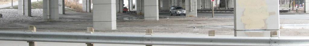
5 The DRL is currently proposed to be constructed in two phases, with the first phase being a subway line from Pape Station on the Bloor-Danforth line southward and then westward to St. Andrew Station on the University subway line. Given the need to deal effectively with growing travel demand to and from the west end, growth in the downtown area west of University Avenue, the need to reduce congestion, and the need to reduce long term environmental damage, the complete DRL should be a single phase project within the current timetable. The F.G. Gardiner Expressway The prospect of a relief line within 15 years should stimulate a re-consideration of current options for the disposition of the Gardiner Expressway. The expressway carries somewhat less than 100,000 vehicles per day in each direction through the downtown area east of Dufferin Street. The expressway has been considered a visual barrier to the waterfront, and is now plagued with structural and maintenance problems related to its age. Proposals for the removal or replacement of the expressway have existed since the 1980 s. The City has recently approved a resumption of an environmental assessment (EA) of four options presented by Waterfront Toronto for addressing the Gardiner problem. Unfortunately, there has been no option for the expressway that would significantly reduce the need for road capacity and demand by encouraging the use of public transit and active transportation. The four options in the EA terms of reference are limited to the portion of the expressway and Lakeshore Boulevard east of Jarvis Street, and are as follows: 1. Do Nothing except undertake basic maintenance. Cost estimated at $50,000,000 over ten years 2. Improve the Expressway by adding architectural wrappers, reconfiguring or realigning some structural pillars to improve pedestrian flow, and removing one or more ramps to reduce the barrier effect of the expressway. Environmental Assessment Study Area, focusing on Expressway east of Jarvis Street only 3. Replace the Expressway with a new elevated (e.g. above the rail corridor), at-grade, or tunnelled expressway. 4. Remove the Expressway east of Jarvis Street and reconfiguring Lakeshore Boulevard to be a grand street albeit that is lower-capacity than current for both Lakeshore and the expressway combined. This option assumes greater transit modal share of trips east of Jarvis Street. However, the need to achieve significant reductions in overall travel by motor vehicle to/from the downtown core remains, for reasons of congestion, environmental health, and liveability, even as downtown employment and residential populations increase. 4
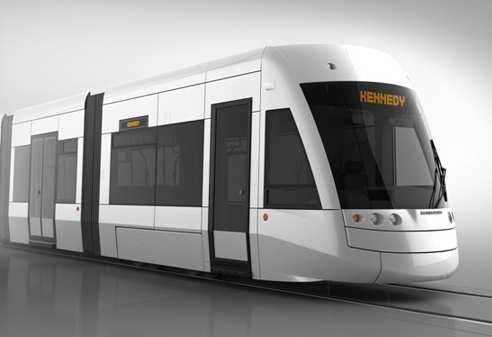
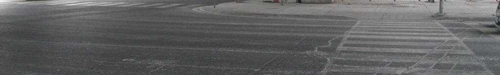
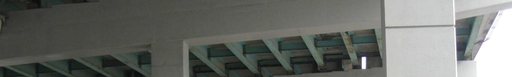
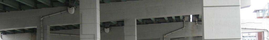
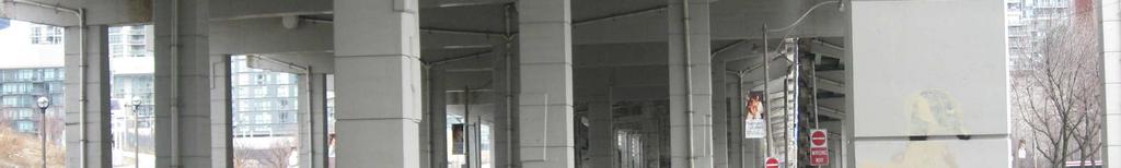
6 Sustainability measures that are more than tokenism need to be a requisite criterion for transportation planning in the Greater Toronto Area. While environmental concerns have taken a back seat to other priorities in recent years, the problems of transportation-based greenhouse gas emissions and pollution remain, and are growing. Investing in environmental protection is not a cost to the economy, but a redirection of economic activity within the economy, and a contributor to overall long-term well-being. Financially, transportation that is dependent on travel by automobile is expensive to drivers and to households, and imposes very high external costs in terms of public subsidy, environmental damage, land losses, congestion costs and other impacts. A Vancouver study estimated this cost to be about $2,700 per vehicle annually. ( The Transportation Transformation Project Proposal An additional long term option, not included in the current EA, is to divert enough automobile traffic from the Gardiner Expressway onto rapid transit that the expressway can be closed I its entirety east of the Humber River. This option is made possible once the downtown relief subway line becomes operational, if an additional light rail transit line is built from Islington Avenue at the Gardiner Expressway to the planned relief line, at Roncesvalles Avenue. The option also includes road adjustments to Lakeshore Boulevard between the Humber River and east of the Don Valley Parkway. This option can be called the Transportation Transformation Project (or simply Transformation ). Components of the Transformation proposal are: 1. Construct a 7.6-kilometre West Commute LRT line to divert a significant number of drivers from traveling all the way to downtown by automobile. Construction would include: An at-grade LRT in the centre of the Gardiner Expressway, from Islington Avenue to west of the Toronto Transit Commission s Humber Loop; LRT stations at Islington, Royal York Road, Parklawn Road and the TTC s Humber Loop; A transition of the LRT from at-grade in the Gardiner corridor down to the Humber Loop; A continuation of the LRT at grade along an upgraded Queensway right-of-way; A tunnelling of the LRT from west of Roncesvalles eastward to intersect with the Queen/Roncesvalles station of the Downtown Relief line; Double-ended light rail vehicles that can avoid the need for turning loops; A multi-level parking garage above the Expressway and the LRT stations at each station, to accommodate between 5,000 to 6,000 vehicles in total (for comparison, Toronto City Hall underground parking capacity is 2,089 spaces). 2. Make road adjustments to enable residual road traffic to access the downtown Toronto area: Adjust express and collector road lanes of the Gardiner Expressway to accommodate LRT stations and access to parking garages. This would involve a transfer of shoulder lanes to the transit right-of-way between LRT stations, plus the transfer of an express 5
7 road lane at stations, compensated by reduced road traffic from the Islington LRT station eastward, and/or an additional collector lane; Immediately east of the Humber River, divert Lakeshore Blvd. traffic onto the Gardiner roadbed and back to its current alignment between the Boulevard Club and Dowling Avenue; Remove Lakeshore Boulevard between these two points, and convert the closed portion of Lakeshore Boulevard to parkland; provide a minimal access road to the parkland around Humber Bay; Add additional lanes to Lakeshore Boulevard where needed to accommodate residual traffic from the Gardiner Expressway; Demolish the Gardiner Expressway from Dowling Avenue to the Don Valley Parkway and to west of Leslie Street; Improve access to downtown Toronto from the Don Valley Parkway, via improvements to existing ramps and roadways. 3. Improve pedestrian access to the waterfront across the core, with safety barriers and covered walkways, and other measures to improve ambience. Parking Level Parking Level Westboun d ramp to expwy here Parking Level 1 Islington Ave. roadway - West of LRT Stati EB ramp to parking & expwy here Embankment 2 Collector Lanes + 2 Shoulders 3 Express Lanes LRT Station 3 Express Lanes 3 Collector Lanes + 2 Shoulders Embankment CENTRE Not included in the Transportation Transformation Project proposal is an option to expand the busy heavy rail right-of-way around Humber Bay to enable additional tracks to be constructed. This could be accomplished by moving the Gardiner Expressway roadbed towards the bay by two or three lanes, and reconstructing overpasses accordingly. This opportunity is not included in the current proposal but may provide important advantages from a long term transportation perspective. Capital Cost Estimates The initial estimated cost of building the West Commute Light Rail Transit line is $700 million. Changes to road alignments and additional lanes, and the demolition of the expressway, are estimated to cost another $1,460 million, for a total of $2.16 billion. This figure includes $1,245 million for expressway demolition, and is net of an estimate of $66 million in revenue from the sale of some expressway lands no longer needed. Refer to Appendix A for more detail. 6
8 Drawing by Sustainable Urban Development Association
9 Drawing by Sustainable Urban Development Association
10 Accurate cost figures for options presented by Waterfront Toronto are not available. The cost comparisons shown in the table below between the Transformation option and other options are presented here only to provide a very broad indication of differences between options. The Improve, Replace, and Remove option capital costs are based only on news reports updated to estimated 2013 values. Detailed costings would be prepared as part of the environmental assessment. Transportation Transformation option $2,200,000,000 Waterfront EA proposal (East of Jarvis Only): Do Nothing option (per Waterfront Toronto) $50,000,000* Per news reports (figures updated to 2013): Improve the Expressway Not available Replace the Expressway 2,500,000,000 Remove the Expressway 1,200,000,000 *Ten-year estimate The options do not include major structural rehabilitation recently approved by Toronto City Council at $505,000,000 over ten years. If the Transformation option is adopted, some of the structural rehabilitation components of the expressway may be avoided or be less extensive. Diversion of Traffic Road traffic coming into the downtown Toronto area can be reduced in a number of ways. An initial estimate of how traffic could be diverted is presented below (a full traffic study would need to be completed as part of the EA process. For travelers using the Gardiner Expressway and Lakeshore Boulevard from the west, an AM Peak Hour scenario is shown in the table below. Diversion % Expressway Lakeshore 2006 EB volume (per City cordon counts) 5,135 3,189 Estimated distribution of diversions: Toronto bypass traffic to 427/401 10% -514 To local roads (from 427 and from the GE) 10% -514 To Go Transit (rail& bus) 10% -514 To Gardiner LRT (based on number of cars only) 35% -1, * To other TTC (Kipling subway, Eglinton LRT, etc.) 10% -514 To Lakeshore Blvd. 25% -1,284 1,284 Residual road traffic 0 4,173 *To Humber Loop LRT parking lot The number of trips diverted to transit can be measured before a decision is made to demolish the Gardiner Expressway. For example, once the LRT is operational, an expressway lane and a Lakeshore Boulevard lane in each direction can be closed off for a year to simulate conditions that would exist after the expressway is closed. 9
11 After the removal of the expressway, the almost 4,200 peak hour motor vehicles will require 4 road lanes in each direction on Lakeshore Boulevard, based on a lane capacity of 1,200 vehicles per hour. The cost of adding a lane in each direction around Humber Bay has been included in the overall proposal costing, as have additions and adjustments to other roads. The use of a reversible lane at some locations, such as between Jameson Avenue and Dan Leckie Way (east of Bathurst Street), and special diversions for some left turns from Lakeshore as a result, can be accommodated. As an option, additional transit use can be encouraged in a number of ways, including not adding road lanes, discouraging parking in the downtown core, and by implementing financial disincentives to driving. As shown above, the West Commute LRT would carry about 2,500 passengers per peak hour (1,800 cars transferred x 1.2 people per car, plus transfers from Lakeshore Boulevard at the Humber loop), which is in the volume range appropriate for light rail. It should be noted that a large portion of travelers to the downtown core from the West come from beyond Toronto s borders. The 2006 eastbound cordon count on the Gardiner Expressway east of the border with Peel Region was 8,316 during the AM peak hour; the eastbound count just east of Highway 427 was 8,189. For travelers coming into the downtown area from the Don valley Parkway and from Lakeshore Boulevard east of the parkway, a scenario for westbound AM peak hour volumes and diversions is as follows: Diversion % Lakeshore Expressway 2006 WB volumes (per City cordon counts) West of DVP Diversion to Richmond Street 10% Through traffic, to 401/427 5% -225 To GO Transit 5% -225 To other TTC (e.g. downtown relief subway line and other) 5% Residual expressway volumes to be diverted (subtotal) 3,368 From Expressway to Lakeshore Blvd. 3,368-3,368 Total scenario WB volume on Lakeshore Blvd. 3,963 0 The residual traffic of almost 4,000 westbound trips during the AM peak hour can be accommodated by four lanes in each direction on Lakeshore Boulevard. During off-peak hours, diversions from use of the expressway and Lakeshore Boulevard to public transit would be less, due to better highway and road speeds. The Transportation Transformation Project proposal includes the construction of three to four multi-level garages at LRT stations at Islington, Royal York, Parklawn Road, and at the Humber Loop. The garages would extend above and across the Gardiner Expressway, LRT stations, 10
12 and intersecting roads. Parking capacities should consider the 2,100 peak hour vehicle diversion to the LRT, plus additional capacity for the remaining peak period, and off-peak diversions to the LRT, for a total of about 5,000 to 6,000 parking spaces. The cost of the garages are not included in the cost estimations identified above, because they are assumed to be separately financed and supported by parking fees. The price set for parking will determine demand, and whether public subsidies will be needed. A $25,000 construction cost per space, amortized at 5% over 20 years, plus operating costs, would require an average of about $42.00 per space per week to break even. Travel Times and Costs Differences in costs for travelers taking the LRT and the DRL compared to driving can be significant. Driving from Islington to Jarvis and King Streets costs about $25.00 (round trip), based on $0.58 per kilometre (CAA Driving Costs report; mid-sized car) and a $10.00 downtown parking charge. Taking the TTC, via the West Commute LRT and Downtown Relief Line, would cost $12.00 per day, based o a $6.00 parking charge and two $3.00 TTC fares. Over a 48-week work year, the differential totals $3,000 in after-income tax dollars. Savings in travel costs compare to increases in travel times resulting from the closure of the Gardiner Expressway. While travel times using the West Commute LRT and DRL are relatively constant, travel times on the Gardiner Expressway and Lakeshore Blvd. are highly variable. The table below shows one possible scenario for off-peak and peak hour travel times for access to and from Jarvis Street at King Street. The figures shown are a mix of theoretical and experienced times. (Additional details are in Appendix B) Compared to driving in 2013 on an uncongested the Gardiner Expressway from Islington Avenue to the Jarvis ramp and then via local streets to Jarvis at King Street, traveling on the West Commute LRT and the Downtown Relief Subway Line may take 19 minutes longer on average, during off-peak hours. During the PM peak hour, this differential is reduced to under 10 minutes, as a result of downtown road congestion. However, transit riders are freed from navigating through traffic, and gain time for other activities while riding (reading, de-stressing, texting). Compared to driving on the Gardiner Expressway in 2013, driving time on the transformed Lakeshore Boulevard between Jarvis and Islington during the PM peak hour is estimated to be about 5 minutes longer. Travel Times Off-Peak PM Peak Hr. From the West - Islington to/from Jarvis & King Using Gardiner Expressway in Using Transformed Gardiner & Lakeshore Blvd Using LRT & Downtown Relief Subway Line (Transfer & wait time = 8 minutes; train running time = 25.4 minutes) From the East - DVP to Jarvis & King Using Gardiner Expressway in Using transformed Lakeshore Blvd
13 System Operating Costs Public operating costs for the Do Nothing and Improve options presented by Waterfront Toronto will not be materially different from current maintenance costs for the expressway and Lakeshore Boulevard east of Jarvis Street. Maintenance costs for the Remove option will be lower than current due to the elimination of the elevated portion of the expressway. The Replace option will result in operating costs similar to those of today except that structural repairs will be largely avoided for at least a decade. The private costs of operating cars and trucks will remain largely unchanged for all options. The Transformation option will result in operating costs and revenues for the West Commute LRT. The revenue-to-cost ratio and net operating subsidies (if any) have not been estimated. Because most of the Gardiner Expressway is maintained in all of the Waterfront Toronto options, the road maintenance costs of the Transformation option will be comparatively much less because the elevated portion of the expressway will no longer exist. Some relatively minor at-grade road maintenance costs will increase where lanes are added. Measuring Effectiveness The most appropriate disposition of the Gardiner Expressway should be determined by a formal application of evaluation criteria across all options. Waterfront Toronto s planned environmental assessment is incomplete in that it includes only four options, all of which are focused on maintaining all or much of the existing motor vehicle traffic volumes, and include very little focus on alternative transportation modes. The Transportation Transformation Project proposal and other transit-oriented options should be included in the environmental assessment, because initial indications are of very substantial benefits of the Transformation option to city residents, compared to the Waterfront Toronto options. A listing of some of the outcomes for the Transportation Transformation option that can be considered are included below. Please note that the list does not focus on impacts of the Downtown Relief Line, in that the DRL is a separate project to which the Transformation project is additional, other than to say here that the Transformation proposal is dependent on the existence of the DRL. Benefits: Transportation Integration of long term transportation strategies (the DRL and the Transformation Project); Reduced core congestion on downtown streets as a result of overall reductions in the number of motor vehicle trips to/from the downtown core; the WT options offer little or no change from current congestion levels on downtown streets; 12
14 Increased transit ridership from the west and from the east/northeast, including ridership on the West Commute LRT, the Downtown Relief Line and, to lesser degree increased GO Transit ridership; Travel mode choices are increased, with the additional West Commute LRT transit option in the West end. This compares to today s forced use of travel by car due to poor transit alternatives; Travelers using the West Commute LRT and DRL will avoid the frustrations of navigating through traffic, and be able to relax on transit vehicles; The inevitability of structural demise of the expressway is fully addressed; North-South pedestrian movement is enhanced by opening up the overhead environment to the sun, reduced noise levels (no reverberations from above) and by providing measures to enhance the walking experience across Lakeshore Boulevard. Urban Environment The need for parking lots in core is reduced; repurposing of these lands to more buildings or to public open space is possible; The Transformation option removes the visual and structural barrier completely, opening up the sky to the ground below; Although Lakeshore Blvd would be widened in some of the downtown area, it may be seen as friendlier than options which retain all or parts of the elevated expressway. Adjacent residential buildings would be free of the expressway s visual obstruction and noise compared to options limited to east of Jarvis Street; The dominating and overshadowing effect of the urban expressway on the Fort York historical site is removed, enhancing its openness and attractiveness; Public lands under the expressway that are sold can enable new structures to be built; excess public lands under the expressway can be transformed into parkland; Environment and Greenspaces Air pollution is likely to be significantly reduced as the West Commute LRT reduces the number of car trips to/from the downtown area. Although slower travel on Lakeshore will increase emissions from residual traffic, reduced congestion to/from removed expressway ramps will reduce emissions; About 3,800 metric tons of greenhouse gas emissions are avoided anually from transfers to transit by travelers to/from the West; The pollution caused by road salt in winter on the expressway will be ended; Overall positive environmental impact as more than 25% of trips by automobile are diverted to transit; Additional sunlight at grade will encourage plantings and green open space; The amount of usable parkland around Humber Bay will be more than doubled. 13
; The sale of some public lands beneath the existing expressway can be")
15 Diversion of Lakeshore Blvd. around Humber Bay (photo) onto the Gardiner roadbed would more than double the usable size of Sunnyside Park. Economic Significant cost savings to travelers using the West Commute LRT and DRL (about $3,000 per year, Islington to Jarvis); The sale of some public lands beneath the existing expressway can be assigned as an offset to capital costs; The desirability and value of residential buildings near the expressway will increase as it is removed; there is little or no such benefit for the WT options. Removal of the expressway improves the attractiveness of the waterfront across the downtown area; Future expressway maintenance costs east of the Humber River are avoided. Negatives: Travel times to/from and through the downtown area will increase. For example, a trip from Islington to Jarvis and King Streets will increase; Disruption of road traffic during demolition of the expressway will be more severe with the Transformation option due to the demolition of the expressway west of Jarvis Street. The period of disruption would depend on the amount of resources applied to do the work. However, the additional transit options that will available at that time (DRL, West Commute LRT, Eglinton LRT, more GO Rail services) would significantly reduce overall impacts; The costs of the Transformation option are additional to the transportation agenda of Metrolinx s Big Move. Waterfront Toronto Options: Timing and Integration If the downtown relief subway line is built within 15 years, the addition of a West Commute LRT would make some of the Waterfront Toronto EA options for the Gardiner Expressway east of Jarvis Street less appropriate or desirable. 14
16 The Improve option, which would include architectural beautification, greening the expressway, and possibly relocating some expressway ramps and pillars, would have a relatively temporary benefit, and may not be worth the cost. The Replace option would not make economic sense if the DRL and West Commute LRT exist, because a redesigned Lakeshore Boulevard should be able to accommodate the residual road traffic. A decision to rebuild the Gardiner Expressway East of Jarvis Street is environmentally inappropriate. If it can be removed in 15 years, why rebuild it now? The Remove option, which would involve a rebuilding of Lakeshore Boulevard East into a Grand Street, plus ramps up to and down from the expressway at Jarvis Street and expansion of the Don Roadway, is most closely aligned with the Transformation option s proposal for transportation east of Jarvis Street. The question is whether the cost of building the ramps is worthwhile if they would be removed a decade or so later. Recommendations The Sustainable Urban Development Association (SUDA) recommends that Metrolinx, the City of Toronto, and/or Waterfront Toronto undertake to refine the information presented in the Transforming Transportation Across the Toronto Waterfront report and that, in addition, SUDA recommends that: 1. The City of Toronto recognize the potential differences in scope and value for money of the options for the disposition of the Gardiner Expressway: An initial capital cost estimate of between $1.2 billion and 2.5 billion for Waterfront Toronto s Remove and Replace options east of Jarvis Street only, compared to an initial cost estimate of $2.16 billion to Transform the entire Gardiner-Lakeshore corridor east of Humber River and including a new light rail transit line; 2. The City of Toronto amend the terms of reference of the Environmental Assessment of Waterfront Toronto s options for the Gardiner Expressway to include the Transportation Transformation Project described above; 3. The City of Toronto request that Metrolinx add the estimated $700 million West Commute LRT as a sub-component of the Downtown Relief Line project that is included in Metrolinx s list of transportation projects; 4. Waterfront Toronto s Do Nothing option, plus basic structural maintenance, be recognized as the best option until longer-term decisions are made regarding the downtown relief subway line and the West Commute LRT. Respectfully submitted. 15

17 John Banka President, SUDA John Stillich Project Lead 16
18 Appendix A Estimate of Capital Costs Unit Cost m$ Transportation Transformation LRT stations under Islington at Queensway and Norseman Islington South LRT station on Gardiner ROW (Includes elimination of shoulder lanes and 75.0 some widening of roadway) Parking garage at Islington South station above Gardiner self-financing Gardiner ramps to/from Islington remain intact. Royal York South LRT station on Gardiner ROW (Includes elimination of shoulder lanes and 75.0 some widening of roadway). Parking garage at Royal York South stn, above Gardiner self-financing Gardiner ramps to/from Parklawn remain intact. LRT alignment, at grade, from east of Islington to west of Humber streetcar loop Descent to Humber streetcar loop Modern enclosed transfer station to/from Lakeshore streetcars 25.0 LRT station at Parklawn, on Gardiner ROW (Includes elimination of shoulder lanes and some 75.0 widening of roadway) Parking garage above Gardiner and RR tracks at Parklawn self-financing GE lane adjustments to accommodate LRT tracks et al 20.0 Upgrade LRT tracks on Queensway around Humber Bay, to East of Parkside Drive (necessary??) Tunnel and underground loop to Roncesvalles subway stn. (Transfers here to DRL and Queen streetcar) Subtotal - Cost of West Commute LRT Road and land Improvements: Immediately east of Ellis Avenue, divert eastbound Lakeshore Blvd. onto the existing Gardiner roadbed Between the Boulevard Club and Dowling Ave., divert Lakeshore traffic from the Gardiner back to the existing Lakeshore Boulevard. Adjustments to Dufferin and Jameson at Lakeshore Blvd Closure of Dowling S. of Springhurst. Bridge removal?? Remove Lakeshore Blvd. from Humber River to east of Boulevard Club Construct 2-lane road S of Gardiner roadbed btwn Humber and E of Parkside Dr., for access to parkland and existing bldgs Access to Queensway via GE and S Kingsway exists; access to Queensway from Parklawn 0.0 unchanged. Convert removed Lakeshore roadbed to parkland 10.0 Remove Expwy roadbed from E of Blvd Club to Dufferin Street Sell the at-grade Gardiner land between the Boulevard Club and Dufferin Street (approx 16 (16.0) acres). Reconfigure access. Bring the separated segments of Lakeshore Blvd. btwn Dowling Ave. & CNE together Add an additional road lane in each direction on Lakeshore Blvd where it is separated btwn Dowling Ave. and BC Rd
19 East of British Columbia Road, where EB and WB lanes rejoin, create a reversible lane from there to Dan Leckie Way (east of Bathurst) Remove the elevated Gardiner Expwy from Dufferin Street ,245.0 to Leslie Street, + ramp to DVP Realign Don River channel/mouth + naturalization/remediation not available Repave/Remediate Lakeshore blvd beneath Expwy after expwy removal (portion directly under GE, east of Spadina) Sell all or parts of unneeded land beneath the former Gardiner Expwy right-of-way for (50.0) development. Btwn Strachan and Spadina, could be 5,000 lin.ft. (Desirable land!) Bring westbound Lakeshore lanes south to join with Lakeshore eastbound lanes, from Dan Leckie Way to Rees Street (E. of Spadina) Create access to Queens Quay from westbound Bathurst Street via detour to Dan Leckie Way 0.5 Add a road lane in each direction from Dan Leckie Way to the Don Roadway Improve pedestrian access across Lakeshore Blvd at all points, with safety barriers, covered 15.0 walkways, elevated walkways where possible, and pedestrian priority where appropriate. Add a lane in each direction to the Don Roadway Create sidewalks and separated bicycle lanes on either side of Lakeshore Blvd., from east of Coronation Park to Leslie Street. Transportation Transformation Project Total Gross Capital Cost 2,161.8 Cost of Downtown Relief Subway Line 7,
20 Appendix B Travel Times To/From the West Non-Peak Hours PM Peak Hour Km. Speed Minutes Speed Minutes Using LRT & DRL: Park & wait & board LRT at Islington LRT - Islington to Roncesvalles via Queensway (incl. stop times Wait time - transfer LRT to subway DRL - Roncesvalles to Jarvis & King Total Time - Using LRT using Expressway: Islngton to/from E. of Humber E.of Humber to/from Jarvis Jarvis - GE to King Park & walk Total time using GE Note: For PM Peak Hour, add at least 5 minutes for congestion accessing the Gardiner. Using the Transformed Lakeshore & Gardiner: Expressway - Islington to E of Humber River Lakeshore using expwy - E of Humber to Jameson Lakeshore - Jameson to Strachan Lakeshore - East of Strachan to Jarvis Jarvis - Lakeshore to King Park & walk Note: For PM Peak Hour, add at least 5 minutes for congestion accessing the Gardiner. When measured over longer distances (e.g. from Hurontario or Oakville), the differential is proportionately less, but higher if travel distance is shorter. 19
Gardiner East. Gardiner Expressway & Lake Shore Boulevard Reconfiguration Environmental Assessment & Urban Design Study
 Gardiner East Gardiner Expressway & Lake Shore Boulevard Reconfiguration Environmental Assessment & Urban Design Study Press Conference February 5, 2014 1 What area are we studying? 2 Gardiner East in
The following notes describe comments received that were written/drawn on maps by workshop participants.
 Stakeholder Workshop Additional Feedback Received Maps and Comment Forms October 5, 2016 The following notes describe comments received that were written/drawn on maps by workshop participants. MAP 1 MAP
Transportation Master Plan Advisory Task Force
 Transportation Master Plan Advisory Task Force Network Alternatives & Phasing Strategy February 2016 BACKGROUND Table of Contents BACKGROUND Purpose & Introduction 2 Linking the TMP to Key Council Approved
Public Event 1 Community Workshops
 Public Event 1 Community Workshops Nov. 24 & Dec. 3, 2016 Welcome Workshop Purpose We re looking to you for ideas and insights to help guide future transportation infrastructure planning in the Park Lawn
APPENDIX 2 LAKESHORE ROAD TRANSPORTATION REVIEW STUDY EXECUTIVE SUMMARY
 APPENDIX 2 LAKESHORE ROAD TRANSPORTATION REVIEW STUDY EXECUTIVE SUMMARY Appendix 2 City of Mississauga Lakeshore Road FINAL REPORT Transportation Review Study December 2010 EXECUTIVE SUMMARY Study Purpose
Appendix 1 Transit Network Analysis
 Appendix 1 Transit Network Analysis APPENDIX 1 TRANSIT NETWORK ANALYSIS The purpose of this appendix is to provide an update on the transit network analysis as it pertains to: i. SmartTrack ii. Scarborough
Moving Cambridge. City of Cambridge Transportation Master Plan Public Consultation Centre. March 7, :00 8:00 PM.
 City of Cambridge Transportation Master Plan Public Consultation Centre March 7, 2018 5:00 8:00 PM Region of Waterloo City of Cambridge Transportation Master Plan Public Consultation Centre March 7, 2018
EXECUTIVE SUMMARY OF CALEDON TRANSPORTATION NEEDS STUDY
 EXECUTIVE SUMMARY OF CALEDON TRANSPORTATION NEEDS STUDY The Caledon Transportation Needs Study has been undertaken as a joint project by the Town of Caledon and the Region of Peel to determine the existing
Submission to Metrolinx on Eglinton LRT - East End. Response to December 2012 Public Meeting
 Submission to Metrolinx on Eglinton LRT - East End Project Response to December 2012 Public Meeting Prepared by: Cycle Toronto, cycleto.ca Authors: John Taranu, Michael Black January 21, 2013 1 Introduction
Appendix A-K Public Information Centre 2 Materials
 Appendix A-K Public Information Centre 2 Materials Our Rapid Transit Initiative Make an impact on the future of transit Join the discussion on Rapid Transit in London You re invited to a Public Information
Markham Sports, Entertainment and Cultural Centre Transportation Overview
 Markham Sports, Entertainment and Cultural Centre Transportation Overview ARENA LOCATION 2 3 TRANSPORTATION VISION IN MARKHAM On April 12, 2011, Markham Council adopted a long-term Transportation Vision
Purpose and Need. Chapter Introduction. 2.2 Project Purpose and Need Project Purpose Project Need
 Chapter 2 Purpose and Need 2.1 Introduction The El Camino Real Bus Rapid Transit (BRT) Project (Project) would make transit and other transportation improvements along a 17.6-mile segment of the El Camino
Regional Transportation Needs Within Southeastern Wisconsin
 Regional Transportation Needs Within Southeastern Wisconsin #118274 May 24, 2006 1 Introduction The Southeastern Wisconsin Regional Planning Commission (SEWRPC) is the official areawide planning agency
WEST AND SOUTH WEST RING ROAD DOWNSTREAM TRAFFIC IMPACTS
 Page 1 of 9 EXECUTIVE SUMMARY Alberta Transportation ( AT ) is preparing to construct the final sections of the Calgary Ring Road. This includes the South West Ring Road ( SWRR ) (from Lott Creek Blvd
Road Alterations - Wellington Street East, Church Street, and Front Street Intersection
 REPORT FOR ACTION Road Alterations - Wellington Street, Church Street, and Front Street Intersection Date: November 1, 2016 To: Toronto and York Community Council From: Director, Public Realm Section,
CITY OF VAUGHAN EXTRACT FROM COUNCIL MEETING MINUTES OF OCTOBER 30, 2012
 CITY OF VAUGHAN EXTRACT FROM COUNCIL MEETING MINUTES OF OCTOBER 30, 2012 Item 31, Report No. 39, of the Committee of the Whole, which was adopted without amendment by the Council of the City of Vaughan
# Southeastern Wisconsin Regional Freeway System Reconstruction Study and Preliminary Recommended Plan
 #70421 Southeastern Wisconsin Regional Freeway System Reconstruction Study and Preliminary Recommended Plan Public Information Meetings and Hearings May June 2002 1 Reason for Freeway System Study 270-mile
York Region Population and Employment Growth
 March 1, 2016 1 York Region Population and Employment Growth York Region needs to comply with The Provincial Growth Plan and new forecasts introduced to 2036 and 2041 2 Regional Official Plan Review York
4 DISRUPTION MANAGEMENT PLAN HIGHWAY 7 RAPIDWAY CONSTRUCTION BETWEEN BAYVIEW AVENUE AND WARDEN AVENUE TOWNS OF MARKHAM AND RICHMOND HILL
 4 DISRUPTION MANAGEMENT PLAN HIGHWAY 7 RAPIDWAY CONSTRUCTION BETWEEN BAYVIEW AVENUE AND WARDEN AVENUE TOWNS OF MARKHAM AND RICHMOND HILL The Transportation Services Committee recommends the adoption of
DON MILLS-EGLINTON Mobility Hub Profile
 Mobility Hub Profile Dundas Don Mills-Eglinton West-Bloor Anchor Hub Gateway Hub N MOBILITY HUBS: Places of connectivity between regional and rapid transit services, where different modes of transportation
DUNDAS WEST-BLOOR Mobility Hub Profile
 Mobility Hub Profile Dundas West-Bloor Anchor Hub Gateway Hub N MOBILITY HUBS: Places of connectivity between regional and rapid transit services, where different modes of transportation come together
Climate Change Action Plan: Transportation Sector Discussion Paper: Cycling
 Climate Change Action Plan: Transportation Sector Discussion Paper: Cycling ontario.ca/climatechange Contents 1. Minister of Transportation s message... 3 2. Introduction... 5 3. Sector Overview and Support
Public Consultation Centre
 Region of Waterloo Transportation Master Plan Update Public Consultation Centre See the Information Package on how to contact the Project Team and complete the Comment Sheet www.regionofwaterloo.ca/en/exploring-the-region/transportation-master-plan.aspx
Transportation Assessment
 Transportation Assessment Midtown Open House February 10, 2018 Overview Midtown in Focus Overview & Purpose of Today Transportation Assessment overview Summary of Transportation work to date Review & Analysis
Harbord Street and Hoskin Avenue Bicycle Lane Upgrades
 STAFF REPORT ACTION REQUIRED and Bicycle Lane Upgrades Date: April 22, 2014 To: From: Wards: Reference Number: Public Works and Infrastructure Committee General Manager, Transportation Services 19 and
Appendix B Workshop Materials
 Appendix B Workshop Materials Public Event 1 Community Workshops Nov. 24 & Dec. 3, 2016 Welcome Workshop Purpose We re looking to you for ideas and insights to help guide future transportation infrastructure
Welcome. The Brooklin Secondary Plan and Transportation Master Plan are collectively referred to as the Brooklin Study.
 Welcome The Town of Whitby is undertaking a study to prepare a Secondary Plan and Transportation Master Plan to guide and manage growth in the Brooklin area. The Brooklin Secondary Plan and Transportation
Building a Toronto that Moves
 Building a Toronto that Moves Image courtesy of the City of Toronto Setting Election Priorities for Walking, Cycling & Public Transit Toronto is a fast-paced, dynamic city. It s a city that moves except
Executive Summary BEYOND THE B-LINE: RAPID TRANSIT LINE PHASE II - COMMERCIAL DRIVE WEST. Final Draft December 13, Appendix B BROADWAY/LOUGHEED
 BEYOND THE B-LINE: BROADWAY/LOUGHEED RAPID TRANSIT LINE PHASE II - COMMERCIAL DRIVE WEST Appendix B Executive Summary Final Draft December 13, 1999 UMA Lloyd Lindley Davidson Yuen Simpson Architects BROADWAY/LOUGHEED
SMARTTRACK RIDERSHIP ANALYSIS
 SMARTTRACK RIDERSHIP ANALYSIS EXECUTIVE SUMMARY Prepared for the City Manager, City of Toronto by: Eric J. Miller, Ph.D. Professor, Department of Civil Engineering Director, Transportation Research Institute
Corporate. Report COUNCIL DATE: June 26, 2006 NO: C012 COUNCIL-IN-COMMITTEE. TO: Mayor & Council DATE: June 22, 2006
 Corporate NO: C012 Report COUNCIL DATE: June 26, 2006 COUNCIL-IN-COMMITTEE TO: Mayor & Council DATE: June 22, 2006 FROM: General Manager, Engineering FILE: 0410-20(MoT/Gate) SUBJECT: Surrey Response on
INTRODUCTION DISCUSSION
 INTRODUCTION A study released by the Toronto Board of Trade reports that Toronto s traffic congestion has grown into a serious and costly problem. It states that Toronto commuters spend about 80 minutes
Hurontario-Main Light Rail Transit (LRT) Project
 Project") Hurontario-Main Light Rail Transit (LRT) Project Credit Reserve Association Annual General Meeting Fausto Natarelli Director, Hurontario-Main LRT Jamie Robinson Communications & Community Relations June
Hurontario-Main Light Rail Transit (LRT) Project Credit Reserve Association Annual General Meeting Fausto Natarelli Director, Hurontario-Main LRT Jamie Robinson Communications & Community Relations June
TRANSPORTATION & MOBILITY
 TRANSPORTATION & MOBILITY ROADWAY SYSTEM There are approximately 40 miles of roadways in Manitou Springs. For planning purposes, roadways are typically assigned a functional classification which defines
Transportation Corridor Studies: Summary of Recommendations
 Transportation Corridor Studies: Summary of Recommendations Route 4 Corridor Study: Route 10 Corridor Study: Route 44 Corridor Study: Route 175 Corridor Study: Route 5/15 Corridor Study: Rentschler Field
Chapter 7. Transportation. Transportation Road Network Plan Transit Cyclists Pedestrians Multi-Use and Equestrian Trails
 Chapter 7 Transportation Transportation Road Network Plan Transit Cyclists Pedestrians Multi-Use and Equestrian Trails 7.1 TRANSPORTATION BACKGROUND The District of Maple Ridge faces a number of unique
INNER LOOP EAST. AIA Rochester Annual Meeting November 13, 2013 TRANSFORMATION PROJECT. Bret Garwood, NBD Erik Frisch, DES
 INNER LOOP EAST TRANSFORMATION PROJECT AIA Rochester Annual Meeting November 13, 2013 Bret Garwood, NBD Erik Frisch, DES Why? We are building a city that encourages walking, biking and enjoying the outdoor
CITY OF HAMILTON PLANNING AND ECONOMIC DEVELOPMENT DEPARTMENT Transportation Planning and Parking Division
 CITY OF HAMILTON PLANNING AND ECONOMIC DEVELOPMENT DEPARTMENT Transportation Planning and Parking Division TO: Chair and Members Public Works Committee COMMITTEE DATE: June 18, 2018 SUBJECT/REPORT NO:
MCTC 2018 RTP SCS and Madera County RIFP Multi-Modal Project Eval Criteria GV13.xlsx
 MCTC 8 RTP SCS and Madera County RIFP Multi-Modal Project Eval Criteria GV.xlsx Madera County Transportation Commission Regional Transportation Plan / Sustainable Communities Strategy Multi-Modal Project
Public Works and Infrastructure Committee. General Manager, Transportation Services. P:\2016\Cluster B\TRA\TIM\pw16009tim.docx
 Ten Year Cycling Network Plan Date: May 3, 2016 STAFF REPORT ACTION REQUIRED PW13.11 To: From: Wards: Reference Number: Public Works and Infrastructure Committee General Manager, Transportation Services
Cutting Canada s Slowest Rush Hour with Public Transportation
 Cutting Canada s Slowest Rush Hour with Public Transportation Denny Yip September 30 th, 2011 1. Introduction Transportation is a key issue in Canada. In the province of Ontario, the Greater Toronto Area
Environmental Assessment Findings & Recommendations. Public Hearing November 13, 2014
 Environmental Assessment Findings & Recommendations Public Hearing November 13, 2014 Welcome! Welcome and Introductions Project and Environmental Assessment Overview Public Comments Adjourn Purpose of
ROUTES 55 / 42 / 676 BUS RAPID TRANSIT LOCALLY PREFERRED ALTERNATIVE
 ROUTES 55 / 42 / 676 BUS RAPID TRANSIT LOCALLY PREFERRED ALTERNATIVE April, 2012 1 INTRODUCTION The need for transit service improvements in the Routes 42/55/676 corridor was identified during the Southern
Scarlett Road Bridge & Road Improvements Lambton Park Community School - Gymnasium Tuesday November 28 th, 2017
 Scarlett Road Bridge & Road Improvements Lambton Park Community School - Gymnasium Tuesday November 28 th, 2017 PROJECT LOCATION 2 SCARLETT ROAD BRIDGE Constructed in 1912, the bridge carries 4 active
Fitting Light Rail through Well-established Communities
 Fitting Light Rail through Well-established Communities San Francisco 2008 Michael D. Madden Chief, Project Development, Maryland Transit Administration Project Setting Located inside the Capital Beltway
DON MILLS-SHEPPARD Mobility Hub Profile
 DON MILLS-SHEPPARD Mobility Hub Profile Dundas Don Mills-Sheppard West-Bloor Anchor Hub Gateway Hub N MOBILITY HUBS: Places of connectivity between regional and rapid transit services, where different
NORTH YORK CENTRE Mobility Hub Profile
 Mobility Hub Profile Dundas North York West-Bloor Centre Anchor Hub Gateway Hub N MOBILITY HUBS: Places of connectivity between regional and rapid transit services, where different modes of transportation
WELCOME TO OPEN HOUSE # 1 June 14, 2017
 Langstaff Road Weston Road to Highway 7 Class Environmental Assessment Study WELCOME TO OPEN HOUSE # 1 June 14, 2017 Please sign in and join our mailing list Purpose of Open House #1 & Study Area York
SANTA CLARA COUNTYWIDE BICYCLE PLAN August 2008
 SANTA CLARA COUNTYWIDE BICYCLE PLAN August 2008 To assist VTA and Member Agencies in the planning, development and programming of bicycle improvements in Santa Clara County. Vision Statement To establish,
NEWMARKET CENTRE Mobility Hub Profile
 Mobility Hub Profile Dundas Newmarket West-Bloor Centre Anchor Hub Gateway Hub N MOBILITY HUBS: Places of connectivity between regional and rapid transit services, where different modes of transportation
SANTA MONICA BOULEVARD CORRIDOR
 CIRCULATION ELEMENT WHITE PAPER NO. 3 SANTA MONICA BOULEVARD CORRIDOR INTRODUCTION From the 1930s to the beginning of Los Angeles freeway era, Santa Monica Boulevard, (previously Route 66, the Beverly
4 Ridership Growth Study
 Clause 4 in Report No. 15 of Committee of the Whole was adopted, without amendment, by the Council of The Regional Municipality of York at its meeting held on November 16, 2017. 4 Ridership Growth Study
Congestion Evaluation Best Practices
 Congestion Evaluation Best Practices Todd Litman Victoria Transport Policy Institute Presented International Transportation and Economic Development Conference 10 April 2014 Congestion Indicators Indicator
to the Public Information Centre for the Downtown Traffic Study
 to the Public Information Centre for the Downtown Traffic Study City of Sault Ste. Marie July 25, 2018 Purpose of Study Determine if changes to one-way corridors can enhance downtown s character and spaces
Southwest Bus Rapid Transit (SW BRT) Functional Planning Study - Executive Summary January 19 LPT ATTACHMENT 2.
 Functional Planning Study - Executive Summary January 19 LPT ATTACHMENT 2.") Southwest Bus Rapid Transit (SW BRT) Functional Planning Study - Executive Summary 2011 January 19 1 of 19 Introduction This executive summary presents the results of the Southwest Bus Rapid Transit (SW
Southwest Bus Rapid Transit (SW BRT) Functional Planning Study - Executive Summary 2011 January 19 1 of 19 Introduction This executive summary presents the results of the Southwest Bus Rapid Transit (SW
Pattullo Bridge Replacement Project Community Connections Phase 2 Consultation. Appendix 3: Open House Display Boards
 Replacement Project Community Connections Phase 2 Consultation Appendix 3: Open House Display Boards November 2016 Welcome! Welcome to the Replacement Project Public Open House We Want to Hear from You
Terwillegar Drive Expressway Draft Concept Plan
 Terwillegar Drive Expressway Draft Concept Plan Anthony Henday Drive to Whitemud Drive November 28 5:00-8:00 p.m. December 1 10:00 a.m. - 3:00 p.m. Let s Talk Today you can: Learn about the new direction
PERFORMANCE ANALYSIS of The Draft 2015 CLRP
 Item 9 PERFORMANCE ANALYSIS of The Draft CLRP Presentation to the Transportation Planning Board September 16, CLRP Performance Analysis 1 What is the Long-Range Transportation Plan (CLRP)? The CLRP identifies
Route 79/Davol Street Corridor Study
 Route 79/Davol Street Corridor Study Fall River, MA Public Information Meeting #2 November 21, 2013 Fall River Heritage State Park Fall River, MA Agenda Welcome and Introductions Overview of Study Process
WHITE PAPER: TRANSIT SERVICE FOR SOUTH SHAGANAPPI
 9/27/2012 TRANSIT PLANNING WHITE PAPER: TRANSIT SERVICE FOR SOUTH SHAGANAPPI 2012 Calgary Transit 1 Table of Contents Purpose... 3 Area of Change... 3 Background... 3 Access to destinations... 5 Connecting
South King County High-Capacity Transit Corridor Study
 HIGH-CAPACITY TRANSIT CORRIDOR STUDY South King County Corridor South King County High-Capacity Transit Corridor Study Corridor Report August 2014 South King County High Capacity Transit Corridor Report
GET TORONTO MOVING TRANSPORTATION PLAN SUMMARY REPORT TABLE OF CONTENTS. Rapid Transit Subways 5. Findings of the 1985 Network 2011 TTC Study 6
 2 GET TORONTO MOVING TRANSPORTATION PLAN SUMMARY REPORT TABLE OF CONTENTS Who we are 4 Policy 4 Rapid Transit Subways 5 Findings of the 1985 Network 2011 TTC Study 6 Transit Projects Around The World 6
DRAFT BUENA VISTA 2020 TRANSPORTATION PLAN
 DRAFT BUENA VISTA 2020 TRANSPORTATION PLAN DEVELOPED BY THE TRANSPORTATION PLANNING DIVISION OF THE VIRGINIA DEPARTMENT OF TRANSPORTATION IN COOPERATION WITH THE U.S. DEPARTMENT OF TRANSPORTATION, FEDERAL
Public Consultation Centre For. Transportation Master Plan Update. Information Package
 Public Consultation Centre For Transportation Master Plan Update Information Package Date Location Hours Tuesday, September 12, 2017 Wednesday, September 13, 2017 Tuesday, September 19, 2017 Cambridge
Complete Streets. Designing Streets for Everyone. Sarnia
 Complete Streets Designing Streets for Everyone Sarnia Complete Streets ~ Sarnia ~ 2018 Introduction Our City is made up of a network of streets that we use to go for a walk, cycle to work, drive to the
CHAPTER 3. Transportation and Circulation
 CHAPTER 3 Transportation and Circulation 3.0 TRANSPORTATION AND CIRCULATION This chapter evaluates traffic circulation, transit, parking, pedestrian, bicycle, and rail operational conditions in the Project
Guildwood Village Traffic Response Prepared by City of Toronto Transportation Department
 Guildwood Village Traffic Response Prepared by City of Toronto Transportation Department 1. Traffic Impacts Associated With Improvements to the Lake Shore East GO Transit Rail Corridor Proposed by Metrolinx
2 BOLTON COMMUTER RAIL SERVICE FEASIBILITY STUDY
 2 BOLTON COMMUTER RAIL SERVICE FEASIBILITY STUDY The Planning and Economic Development Committee recommends the adoption of the recommendations contained in the following report dated April 15, 2011 from
2.2 TRANSIT VISION 2040 FROM VISION TO ACTION. Emphasize transit priority solutions STRATEGIC DIRECTION
 TRANSIT VISION 2040 FROM VISION TO ACTION TRANSIT VISION 2040 defines a future in which public transit maximizes its contribution to quality of life with benefits that support a vibrant and equitable society,
Standing Committee on Policy and Strategic Priorities
 POLICY REPORT Report Date: January 15, 2019 Contact: Steve Brown Contact No.: 604.873.9733 RTS No.: 12955 VanRIMS No.: 08-2000-20 Meeting Date: January 30, 2019 TO: FROM: SUBJECT: Standing Committee on
TRANSPORTATION NEEDS ASSESSMENT
 TRANSPORTATION NEEDS ASSESSMENT A travel demand analysis was carried out to determine the operational issues and the potential benefit that adding traffic capacity would have on the road network. All the
City of Wayzata Comprehensive Plan 2030 Transportation Chapter: Appendix A
 A1. Functional Classification Table A-1 illustrates the Metropolitan Council s detailed criteria established for the functional classification of roadways within the Twin Cities Metropolitan Area. Table
State Road 54/56 Tampa Bay s Northern Loop. The Managed Lane Solution Linking I-75 to the Suncoast Parkway
 State Road 54/56 Tampa Bay s Northern Loop The Managed Lane Solution Linking I-75 to the Suncoast Parkway SUNCOAST PARKWAY Both I 75 and the Suncoast Parkway are planning, or in the process of constructing,
ITEM 2.3 South of Fraser Rapid Transit Surrey-Langley technology decision. That the Mayors Council on Regional Transportation receive this report.
 TO: FROM: Mayors Council on Regional Transportation Geoff Cross, Vice President of Planning and Policy DATE: September 27, 2017 SUBJECT: ITEM 2.3 South of Fraser Rapid Transit Surrey-Langley technology
Chapter 4 Transportation Strategies to Support Growth
 City of Brantford Chapter 4 Transportation Strategies to Support Growth TABLE OF CONTENTS 4.1 DESIGNING A TRANSPORTATION STRATEGY... 1 4.2 STRATEGIES TO INCREASE SUPPLY... 2 4.2.1 Optimizing the Existing
APPENDIX D: SACRAMENTO URBAN AREA TRANSPORTATION PRIORITIES
 1 County County County County 2 Yolo Arterial Roadway Collector Roadway Urban Residential Street Rural Residential Roadway I-80 / U.S. 50 Bus/Carpool Lanes in both directions Richards Blvd PM Yol 80 0.237
VOLUME 5 Technology and Option Evaluation
 VICTORIA REGIONAL RAPID TRANSIT Victoria / West Shore Link VOLUME 5 Technology and Option Evaluation August 2011 Prepared for BC Transit by SNC-Lavalin Inc McElhanney Consulting Services Ltd Errata 1.
CPC Parking Lot Riverside Drive. Transportation Rationale
 CPC Parking Lot Transportation Rationale Prepared By: NOVATECH Suite 200, 240 Michael Cowpland Drive Ottawa, Ontario K2M 1P6 September 2015 Novatech File: 114093 Ref: R-2015-153 Table of Contents 1.0 INTRODUCTION...
PG29.6 REPORT FOR ACTION. Downtown Mobility Strategy SUMMARY
 PG29.6 REPORT FOR ACTION Downtown Mobility Strategy Date: April 17, 2018 To: Planning and Growth Management Committee From: Chief Planner and Executive Director, City Planning and General Manager, Transportation
Roads and Vehicular Traffic Design Principles. Roads and Vehicular Traffic Recommendations
 CIRCULATION AND PARKING roads and vehicular traffic The Campus Master Plan updates the campus transportation network through a multi-modal approach that encourages walking and biking while improving vehicular
Welcome. Thank you for your interest in the Lewis & Clark Viaduct Concept Study
 Welcome Thank you for your interest in the Lewis & Clark Viaduct Concept Study Please use the arrows in the upper left hand corner to navigate through the presentation. Use the envelope icon to ask a question
2011 Transportation Tomorrow Survey. Data Presentation
 2011 Transportation Tomorrow Survey Data Presentation Participating Agencies Conduct of the Survey Supporting Agencies of TTS Agency 1986 1991 1996 2001 2006 2011 Mininstry of Transportation, Ontario Y
North Coast Corridor:
 North Coast Corridor: Connecting People, Transportation & Environment Legislative Hearing: 11.8.10 1 North Coast Corridor Region s Lifeline A Regional Strategy Mobility, Economy & Environment North Coast
US 19 Pedestrian and Bicycle Safe Access to Transit Corridor Study
 US 19 Pedestrian and Bicycle Safe Access to Transit Corridor Study DRAFT Technical Memorandum #6 Cost and Benefit Evaluation Methodology August 2016 Prepared for: FLORIDA DEPARTMENT OF TRANSPORTATION DISTRICT
West Dimond Blvd Upgrade Jodhpur Street to Sand Lake Road
 West Dimond Blvd Jodhpur St to Sand Lake CSS Transportation Project Summary Municipality of Anchorage Project # 05 005 Project Manager: John Smith, P.E. (MOA PM&E) Project Administrator: Julie Makela,
McKenzie Interchange Project Fall 2015 Engagement. Appendix 2: Engagement Materials and Feedback Form
 Fall 2015 Engagement Appendix 2: Engagement Materials and Feedback Form Welcome to the McKenzie Interchange Project Open House! Purpose of Open House To provide you with information regarding the project
Nomination. Halton Region in Context
 Transportation Association of Canada Sustainable Urban Transportation Award Nomination of: Region of Halton Regional Transportation Master Plan Study March 2005 Nominated by: Nomination The TAC Sustainable
TRASBURG RANSPORTATION
 TRASBURG RANSPORTATION LAN DEVELOPED BY THE TRANSPORTATION PLANNING DIVISION OF THE VIRGINIA DEPARTMENT OF TRANSPORTATION IN COOPERATION WITH THE U.S. DEPARTMENT OF TRANSPORTATION, FEDERAL HIGHWAY ADMINISTRATION
Chapter 5 Future Transportation
 Chapter 5 Future Transportation The Future Land Use Plan identifies the desired land use designations. The land uses desired for Crozet depend, in large part, on the success of the transportation system,
APPENDIX B.2 TABLE 2 CITY OF TORONTO PRELIMINARY DRAFT DEVELOPMENT-RELATED CAPITAL PROGRAM TRANSIT (BALANCE) Grants/ Subsidies/Other Recoveries
 Grants/ Subsidies/Other Recoveries") PRELIMINARY DRAFT DEVELOPMENTRELATED CAPITAL PROGRAM Description 0 Related s 2.0 2.1 STREETCAR RELATED INFRASTRUCTURE 2.1.1 Surface Track 2.1.1.1 King/Queen/Roncesvalles Modifications Subtotal Surface
PRELIMINARY DRAFT DEVELOPMENTRELATED CAPITAL PROGRAM Description 0 Related s 2.0 2.1 STREETCAR RELATED INFRASTRUCTURE 2.1.1 Surface Track 2.1.1.1 King/Queen/Roncesvalles Modifications Subtotal Surface
STREET AND HIGHWAY PLAN
 STREET AND HIGHWAY PLAN Introduction The street and highway system in the Winston-Salem Urban Area consists of thousands of miles of traffic carrying facilities, ranging from short local residential streets
MOUNTAIN HOUSE SPECIFIC PLAN I 9.1 INTRODUCTION ASSUMPTIONS TRANSPORTATION FACILITIES TRANSPORTATION IMPROVEMENTS PHASING 9.
 CHAPTER NINE: TRANSPORTATION AND CIRCULATION 9.1 INTRODUCTION 9.1 9.2 ASSUMPTIONS 9.1 9.3 TRANSPORTATION FACILITIES 9.1 9.4 TRANSPORTATION IMPROVEMENTS PHASING 9.3 LIST OF FIGURES LIST OF TABLES Figure
Access BART: TOD and Improved Connections. October 29, 2008
 Access BART: TOD and Improved Connections October 29, 2008 1 Access BART Study Goals Evaluate at the system-level land use and access scenarios to optimize ridership Identify station clusters that provide
BUS RAPID TRANSIT. A Canadian Perspective. McCormick Rankin International. John Bonsall P.Eng
 BUS RAPID TRANSIT A Canadian Perspective Why choose BRT? Because it is a practical and cost effective rapid transit solution for the most common types of land use in urban Canada Operating experience shows
Topics To Be Covered. Summarize Tier 2 Council Direction Discuss Mill and Ash Alternatives Next Steps
 Topics To Be Covered Summarize Tier 2 Council Direction Discuss Mill and Ash Alternatives Next Steps Tier 2 Council Direction Dismiss Bus Rapid Transit along the Union Pacific Railroad Dismiss Bus Rapid
5/7/2013 VIA . RE: University Village Safeway Expansion (P13-019)
") 5/7/2013 VIA EMAIL David Hung, Associate Planner Community Development Department, Current Planning Division City of Sacramento 300 Richards Boulevard, 3 rd Floor Sacramento, CA 95811 RE: University Village
5/7/2013 VIA EMAIL David Hung, Associate Planner Community Development Department, Current Planning Division City of Sacramento 300 Richards Boulevard, 3 rd Floor Sacramento, CA 95811 RE: University Village
Corridor Advisory Group and Task Force Meeting #10. July 27, 2011
 Corridor Advisory Group and Task Force Meeting #10 July 27, 2011 1 Agenda Recap CAG/TF #9 Public Meeting #2 Summary Single Mode Alternatives Evaluation Results Next Steps 2 3 CAG/TF #9 Recap CAG /TF #9
Frequently Asked Questions (FAQ)
") Frequently Asked s (FAQ) Study Process... 2 Rapid Transit Service and Operations... 5 Public Consultation... 8 Business Impacts... 8 Design and Property Impacts... 9 Construction Impacts...12 Traffic,
Frequently Asked s (FAQ) Study Process... 2 Rapid Transit Service and Operations... 5 Public Consultation... 8 Business Impacts... 8 Design and Property Impacts... 9 Construction Impacts...12 Traffic,
Evaluation and Changes to Pedestrian Priority Phase Signal (Scramble Crossing) at Bay Street and Bloor Street
 at Bay Street and Bloor Street") PW2.2 STAFF REPORT ACTION REQUIRED Evaluation and Changes to Pedestrian Priority Phase Signal (Scramble Crossing) at Bay Street and Bloor Street Date: February 12, 2015 To: From: Public Works and Infrastructure
PW2.2 STAFF REPORT ACTION REQUIRED Evaluation and Changes to Pedestrian Priority Phase Signal (Scramble Crossing) at Bay Street and Bloor Street Date: February 12, 2015 To: From: Public Works and Infrastructure
WHAT IFS: Over the course of
 WHAT IFS: Over the course of the 422plus Project certain questions have arisen multiple times at meetings, briefings and on-line at the website. Most of these questions start with WHAT IF. WHAT IF vehicle