SR-714 (Monterey Road) Martin County, Florida
|
|
|
- Lionel Clarke
- 6 years ago
- Views:
Transcription
1 S-714 (Monterey oad) Martin County, Florida Financial Project ID: Work Program Item No. (Old): Federal Project ID:FL Grade Separation Feasibility at Dixie Highway and FEC ailroad Prepared by H. J. oss Associates, Inc. for Florida Department of Transportation Office of Planning and Environmental Management District IV May 2001
2 S-714 (Monterey oad) Grade Separation Feasibility at Dixie Highway and FEC ailroad TABLE OF CONTENTS INTODUCTION 1 EXISTING CONDITIONS 1 CONSTAINTS 2 ALTENATE 1 4 ALTENATE 2A 6 ALTENATE 2B 9 ALTENATE 3 11 ALTENATE 4 14 APPENDIX A PELIMINAY COST ESTIMATES APPENDIX B FIGUES
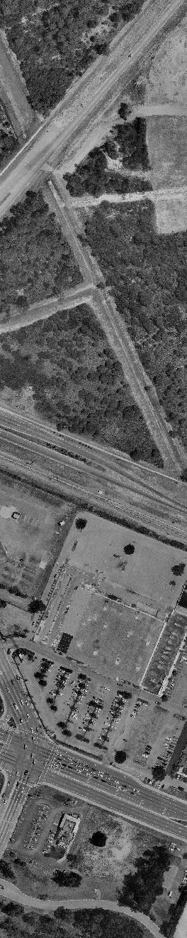
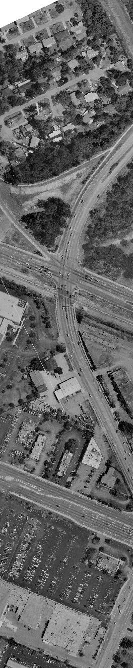
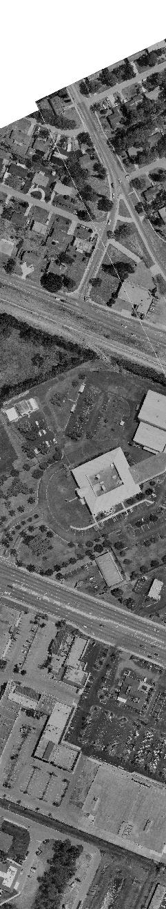
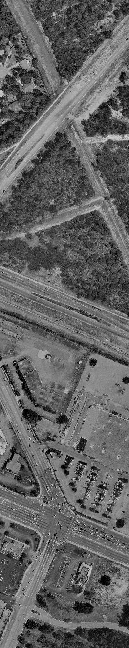
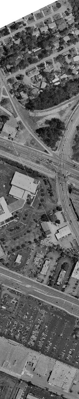
3 S-714 (Monterey oad) Grade Separation Feasibility at Dixie Highway and FEC ailroad INTODUCTION The Florida Department of Transportation is investigating alternates for intersection improvements to S-714 (Monterey oad) at US-1 and Dixie Highway. These improvements include raising Monterey oad over the existing Florida East Coast (FEC) railroad or tunneling under the tracks in the City of Stuart. The main purpose of this study is to investigate the feasible alternates in having a grade separation of Monterey oad, Dixie Highway and the railroad to minimize delays to vehicular traffic. The study area extends east of Dixie Highway by a sufficient distance to bring the roadway back to grade from a new bridge/tunnel to the proposed 4-lane roadway section. The Dixie Highway limits are to 16 th Street on the north and approximately 800 feet south of Monterey oad. The US-1 limits are approximately 300 feet north and south of the intersection with Monterey oad. The following four (4) principal alternatives are part of the evaluation: Alternative 1: Improve the US-1 and the Dixie Highway/FEC intersections with Monterey oad while maintaining the existing at-grade railroad crossing. This would include lane widening, intersection reconstruction, adding turn lanes, and general improvements for access management. However, this alternative will not improve the present railroad crossing condition. Alternative 2A/AB: Plateau the Monterey oad and Dixie Highway intersection in order to provide a bridge above the FEC railroad. This alternative brings Monterey oad and Dixie Highway traffic over the railroad and eliminates all at-grade crossings. Alternative 3: aise only Monterey oad with a bridge over the FEC ailroad and Dixie Highway. This alternate has frontage roads connecting Dixie Highway to US-1 that cross the railroad at grade. Alternative 4: Provide a tunnel for Monterey oad beneath Dixie Highway and the FEC ailroad. This is similar to the third alternate, but requires fewer impacts to Monterey oad because the roadway clearance below the railroad is less than the clearance required by placing a roadway above the railroad. This alternate has frontage roads connecting Dixie Highway to US-1 that cross the railroad at grade. EXISTING CONDITIONS Monterey oad is an undivided urban typical 4-lane roadway, which reduces to 2 lanes east of Dixie Highway in this section. There is an at-grade crossing with the FEC ailroad between US-1 and Dixie Highway. The at-grade condition is where the roadway and railroad physically intersect and the vehicles must drive over the railroad tracks in order to continue along Monterey oad. The trains typically cross this intersection every hour, 1
4 S-714 (Monterey oad) Grade Separation Feasibility at Dixie Highway and FEC ailroad creating traffic congestion on Monterey oad which backs up in both directions. Along with the general delays to motorists attempting to reach a destination east or west of this area, the condition is worsened by traffic backups along US-1 and Dixie highway since no turning movements can be made onto Monterey oad when a train is crossing. US-1 is a major arterial roadway with three (3) lanes in each direction plus dual-left turn lanes and single right-turn lanes at the intersection with Monterey oad. Dixie Highway is a 2-lane roadway that parallels the FEC ailroad and serves as a collector road for the adjacent residential community. Dixie Highway widens at Monterey oad for right and left turn lanes. CONSTAINTS The constraints that are imposed on the various alternatives, which limit the extent of improvements are the following: 1. The 34:1 sloped Approach Surface to unway at Witham Field (airport). The approach surface imposes height restrictions on vehicles, light poles, traffic signals, and any other appurtenance that could penetrate this airspace surface. The Approach Surface begins 200 feet from the end of unway and slopes upward at a rate of 34:1. The width of the surface is 500 feet at its beginning and widens to 1,700 feet at a point 30,000 feet from the beginning. Outside of this envelope are side slopes of 7:1, which extend up to 150 feet above the airport elevation. No penetrations are allowed into this surface unless specifically approved by a waiver from the Federal Aviation Administration. 2. Palm Beach oad also poses a constraint since it presently causes a 5-point intersection at Dixie Highway and Monterey oad. This 5 th point is undesirable from a traffic standpoint. 3. Driveway access to many adjacent businesses along Monterey oad between US-1 and Dixie Highway imposes constraints on improvements given the desire to maintain access. Current access management criteria and geometric improvements for the Monterey oad project preclude having many of these access points continue in their present location. 4. Access management for FDOT roadways requires that current traffic control criteria be implemented. This requirement impacts the current Palm Beach oad where it intersects Dixie Highway. This intersection is too close to the Monterey oad/dixie Highway intersection according to the roadway classification and the traffic conditions on Dixie Highway. 2
5 S-714 (Monterey oad) Grade Separation Feasibility at Dixie Highway and FEC ailroad 5. Other constraints are the proximity of US-1 to Dixie Highway in terms of geometrically providing a raised roadway over the railroad and bringing the roadway back to grade at the US-1 intersection. This creates many issues concerning roadway design speed, sight distances, weaving and turning movements. 3
6 S-714 (Monterey oad) Grade Separation Feasibility at Dixie Highway and FEC ailroad ALTENATE 1 ETAIN AT-GADE AILOAD COSSING AND POVIDE OADWAY IMPOVEMENTS DESCIPTION This alternate involves improvements to the existing S-714 (Monterey oad), US-1, and Dixie Highway roadways to enhance traffic movement. The railroad crossing would remain in its present location as an at-grade crossing with Monterey oad. As a result, vehicles must stop for all train movements through the crossing. Appendix B - Figure 1 shows a plan view of Alternative 1. ADVANTAGES 1. Two (2) additional lanes on Monterey oad improve traffic flow by allowing more vehicles to pass through the intersections on green lights. 2. estricted movements from driveways at adjacent properties allow enhanced traffic flow along Monterey oad since fewer vehicles may pull in and out of driveways. 3. There are minimal impacts to airport property resulting from a small piece of rightof-way being taken. 4. Overall, only minor right-of-way acquisition is necessary for the entire improvement under this alternate. 5. The cost of the improvement is the least of the four (4) alternates. DISADVANTAGES 1. This alternate does not alleviate the inconvenience of an at-grade railroad crossing and the associated traffic back-ups from trains crossing Monterey oad. IMPACTS TO ADJACENT POPETIES 1. Minor right-of-way acquisitions are needed. 2. It is necessary to reconfigure eleven (11) parking spaces at the United Way building on the south side of Monterey oad. 4
7 S-714 (Monterey oad) Grade Separation Feasibility at Dixie Highway and FEC ailroad 3. Along the south side of its property, the Stuart Chase Bank loses its driveway access to the drive-up tellers. 4. Bonos restaurant loses thirteen (13) parking spaces for the new right turn lane from Monterey oad to US-1. MINO VAIATIONS TO THIS ALTENATE None FATAL FLAWS None COST ANALYSIS The approximate construction cost for the intersection improvement only with this alternate is $3,200,000. The total cost of the right-of-way and the remainder of the roadway improvement in the full PD&E study is $31,020,000. efer to Appendix A for a detailed estimate of the construction cost (Table A-1) and full PD&E study cost (Table A-6). 5
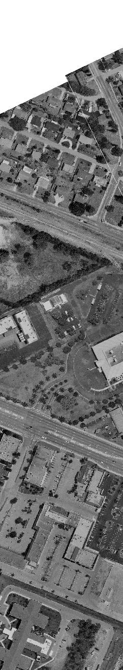
8 S-714 (Monterey oad) Grade Separation Feasibility at Dixie Highway and FEC ailroad ALTENATE 2A AISED INTESECTION AND BIDGE OVE AILOAD DESCIPTION This alternate involves plateauing the entire Monterey oad and Dixie Highway intersection and providing a bridge structure over the FEC ailroad. All movements are elevated thereby eliminating all at-grade crossing of the roadway and the railroad. A signalized intersection is provided at Monterey oad and Dixie Highway. Appendix B - Figure 2A shows a plan view of Alternative 2A. ADVANTAGES 1. Elimination of the at-grade railroad crossing allows traffic on Monterey oad and Dixie Highway to avoid waiting for trains. 2. A single span bridge over the railroad incurs the least cost compared to Monterey oad spanning Dixie Highway and the railroad with two (2) bridge spans. 3. By eliminating the at-grade railroad crossing, uninterrupted access is provided for emergency vehicles. 4. There is minimal impact to airport property requiring only minor right-of-way acquisition. 5. This alternate uses the narrowest corridor width for Monterey oad improvements versus having a bridge or a tunnel that widens the corridor by having frontage roads along Monterey oad. 6. Additional lanes on Monterey oad improve traffic flow by allowing more vehicles to pass through the intersections on the green lights. DISADVANTAGES 1. Access from Monterey oad is eliminated to many businesses. All but two (2) of the businesses have an alternate access point. These impacts are described in detail under Impacts to Adjacent Properties. 2. Access is eliminated to the convenience store/office building from Dixie Highway. 3. The intersection at Palm Beach oad with Dixie Highway is eliminated. Local residents access Palm Beach oad from 16 th Street approximately ¼-mile north of 6
9 S-714 (Monterey oad) Grade Separation Feasibility at Dixie Highway and FEC ailroad this intersection. This is a residential street that is not configured to accommodate highway traffic. 4. Five (5) homes along Dixie Highway are needed to accommodate the new profile for Dixie Highway. 5. Access to the FPL property is limited to right turn in and out only. IMPACTS TO ADJACENT POPETIES 1. Stuart News/TV Station loses its driveway access from the north side of Monterey oad. 2. Mosley & Son Construction loses its only driveway access from the north side of Monterey oad and becomes landlocked. 3. The Atlantic Tire Center loses its only driveway access from the north side of Monterey oad and becomes landlocked. 4. The office/shop building loses its driveway access from the north side of Monterey oad; however, it retains access from US Along the south side of its property, the Stuart Chase Bank loses its driveway access to the drive-up tellers. 6. Bonos restaurant loses thirteen (13) parking spaces for the new right turn lane from Monterey oad to US Property acquisition and driveway reconfigurations are required to continue access to the FPL and United Way properties from the south side of Monterey oad. 8. Parking at the United Way building requires reconfiguration. 9. Acquisition of the convenience store/office building on Dixie Highway is required. 10. Acquisition of five (5) residential homes north of the Palm Beach oad intersection is required in order to bring Dixie Highway down to grade. MINO VAIATIONS TO THIS ALTENATE 1. Provide the right-turn movements at ground level (still crossing the railroad) and only elevate the through movements for Monterey oad and Dixie Highway. Access to 7
10 S-714 (Monterey oad) Grade Separation Feasibility at Dixie Highway and FEC ailroad businesses along Monterey oad will be provided in this variation by the at-grade right turn movements. FATAL FLAWS None COST ANALYSIS The approximate construction cost for the intersection improvement only with this alternate is $22,000,000. The total cost of the right-of-way and the remainder of the roadway improvement in the full PD&E study is $60,060,000. efer to Appendix A for a detailed estimate of the construction cost (Table A-2) and full PD&E study cost (Table A-6). 8
11 S-714 (Monterey oad) Grade Separation Feasibility at Dixie Highway and FEC ailroad ALTENATE 2B AISED INTESECTION AND BIDGE OVE AILOAD DESCIPTION This alternate is the same as Alternate 2A with the addition of an exit ramp from eastbound Monterey oad and northbound Dixie Highway to northbound Palm Beach oad. Appendix B - Figure 2B shows a plan view of Alternative 2B. ADVANTAGES The advantages are the same as Alternate 2A with the following additional advantage: 1. The exit ramp allows traffic movement to northbound Palm Beach oad and reduces amount of traffic using 16 th Street through the neighborhood. DISADVANTAGES The disadvantages are the same as Alternate 2A with the following additional disadvantage(s): 1. Acquisition of more airport land is required when compared to Alternate 2A. 2. This alternate cost $8.5 million more than Alternate 2A. IMPACTS TO ADJACENT POPETIES The impacts to adjacent properties are the same as Alternate 2A with the following additional impact: 1. Acquisition of more airport land is required. MINO VAIATIONS TO THIS ALTENATE 1. Provide the right-turn movements at ground level (still crossing the railroad) and only elevate the through movements for Monterey oad and Dixie Highway. Access to businesses along Monterey oad will be provided in this variation by the at-grade right turn movements. 9
12 S-714 (Monterey oad) Grade Separation Feasibility at Dixie Highway and FEC ailroad FATAL FLAWS None COST ANALYSIS The approximate construction cost for the intersection improvement only with this alternate is $30,500,000. The total cost of the right-of-way and the remainder of the roadway improvement in the full PD&E study is $70,450,000. efer to Appendix A for a detailed estimate of the construction cost (Table A-3) and full PD&E study cost (Table A-6). 10
13 S-714 (Monterey oad) Grade Separation Feasibility at Dixie Highway and FEC ailroad ALTENATE 3 ELEVATE MONTEEY OAD OVE DIXIE HIGHWAY AND FEC AILOAD DESCIPTION This alternate provides a bridge on Monterey oad that goes over Dixie Highway and the FEC ailroad. The through traffic on Monterey oad continues uninterrupted since it does not intersect Dixie Highway or the railroad. All turning movements are at ground level with crossings at the railroad. Frontage roads are provided along the sides of the elevated through-lanes of Monterey oad to connect entrance and exit movements from adjacent properties. Frontage roads also allow turning movements at Dixie Highway. Bike lanes and sidewalks are provided at grade. Dixie Highway traffic functions similar to the way it does in its present condition. However; traffic will flow more smoothly since there is not a full intersection with the mainline of Monterey oad. Only the turning movements to and from Monterey oad will stop traffic along Dixie Highway under this scenario. Trains moving through this area will continue to delay turning movements from Dixie Highway to westbound Monterey oad. Appendix B - Figure 3 shows a plan view of Alternative 3. ADVANTAGES 1. Through traffic movement for Monterey oad is provided over the railroad tracks without interruptions from trains crossing. 2. Traffic flow along the mainline of Monterey oad is improved by eliminating a traffic signal. 3. Frontage roads along Monterey oad allow access to adjacent properties on Monterey oad. However, the movements at these driveways will be restricted to right turns in and out only. 4. Palm Beach oad can function in its present condition with access from northbound Dixie Highway. 5. Property acquisition is unnecessary along Dixie Highway as access to businesses and residences is not disturbed. 11
14 S-714 (Monterey oad) Grade Separation Feasibility at Dixie Highway and FEC ailroad DISADVANTAGES 1. This alternates requires two (2) bridge spans to go over Dixie Highway and the railroad at a higher cost. 2. Monterey oad is required to be wider due to sight distances along the curve where it crosses Dixie Highway and the railroad. 3. Intricate signing and markings on US-1 is required to direct traffic onto Monterey oad as well as the frontage road and vice versa. 4. A complex traffic signal phasing and signal timing for the two (2) separate left-turns is required. There is inadequate room for weaving movements at the end of the Monterey oad ramp bridge. 5. More right-of-way acquisition is necessary on the south side of Monterey oad (at FPL property) to accommodate the wider mainline road. 6. ailroad grade crossings for frontage roads are necessary for all vehicular, bicyclist, and pedestrian movements. 7. No access is provided to Monterey oad from the adjacent properties. ight turns in and out of the frontage road are the only movement possible. IMPACTS TO ADJACENT POPETIES 1. The Stuart News, Mosley & Son Construction, Atlantic Tire, and the #1989 Building properties are affected. These sites are limited to right turns in and out from their properties to the frontage road along the north side of Monterey oad. 2. Access to the FPL and United Way properties on the south side of Monterey oad is only achieved through right turns in and out of the frontage road. Vehicles entering these properties could not return to US-1 via Monterey oad, but would have to travel either east on Monterey and make a U-turn to return to US-1 or to US-1 via Dixie Highway. 3. The United Way building loses its driveway and front parking. MINO VAIATIONS TO THIS ALTENATE 1. The existing northbound Dixie Highway turn-off to Palm Beach oad is removed. The north leg of Palm Beach oad that is 600 feet north the Monterey oad and Dixie Highway intersection is converted to a 2-way traffic scenario accommodating the right turn movement from Dixie Highway onto Palm Beach oad. 12
15 S-714 (Monterey oad) Grade Separation Feasibility at Dixie Highway and FEC ailroad 2. The bridge that goes over the railroad further to the west is extended and a U-turn roadway is provided beneath Monterey oad on the west side of the tracks. This enables vehicles exiting from Scotty s, United Way, and FPL to return to US The westbound frontage road is limited to a northbound movement onto US-1. This eliminates the left turn movement onto US-1 from this lane. FATAL FLAWS 1. estricting or eliminating the left turn movements from westbound Monterey oad to southbound US-1 because of the lack of weaving space makes this alternative undesirable. The weaving involves a vehicle traveling westbound on the frontage road along the north side of Monterey oad cutting across three (3) lanes of traffic within a short distance in order to get into the left-turn lanes on Monterey oad to turn left onto US-1. This situation does not meet with FDOT criteria and is hazardous to drivers. This left turn restriction forces motorists to access US-1 from Dixie Highway at Decker Avenue, which is approximately 2/3 mile north of Monterey oad, or at Indian Street, which is approximately 1¼-miles south of Monterey oad. 2. Left turns from the westbound frontage road and from Monterey oad onto southbound US-1 require a 5-phase signal similar to a 5-point intersection. This reduces traffic capacity. 3. At-grade railroad crossings remain for the frontage roads, which does not comply with the overall intent of eliminating the at-grade crossings. COST ANALYSIS The approximate construction cost for the intersection improvement only this alternate is $9,700,000. This does not include the right-of-way cost or the remainder of the roadway improvements in the full PD&E study. efer to Appendix A for a detailed estimate of the intersection construction cost (Table A-4). 13
16 S-714 (Monterey oad) Grade Separation Feasibility at Dixie Highway and FEC ailroad ALTENATE 4 TUNNEL MONTEEY OAD BENEATH DIXIE HIGHWAY AND THE AILOAD DESCIPTION This alternate provides a tunnel structure allowing only the Monterey oad through-lanes to pass beneath Dixie Highway and the railroad. All turning movements are at grade with crossings at the railroad. Frontage roads are provided along the sides of the depressed through-lanes to connect Monterey oad to Dixie Highway and to allow turning movements from the adjacent properties. Bike lanes and sidewalks are provided at grade. This alternate is similar to the bridge alternate in terms of traffic movement. Because the frontage roads and turning movements are still at-grade and not connected to the tunnel, the turning vehicles, pedestrians, and bicyclists will have to wait for trains to cross the intersection. Appendix B - Figure 4 shows a plan view of Alternative 4. ADVANTAGES 1. The frontage roads provide access to properties along Monterey oad (right turn in and out only). 2. Palm Beach oad functions in its present condition. 3. Businesses and residences along Dixie Highway are unaffected. DISADVANTAGES 1. A wider roadway is required in comparison to the bridge alternative due to the horizontal sight distance requirements of the tunnel. This causes more right-of-way to be acquired along the Monterey oad corridor. 2. Turning movements from the westbound frontage road on the north side of Monterey oad to southbound US-1 requires a separate signal phase since there is not enough room for weaving movements at the end of the Monterey oad tunnel. 3. Frontage roads require at-grade railroad crossings. This includes vehicular, bicyclist, and pedestrian movements, which stop for all train crossings. 4. The tunnel is the most costly alternate to construct. 14
17 S-714 (Monterey oad) Grade Separation Feasibility at Dixie Highway and FEC ailroad IMPACTS TO ADJACENT POPETIES 1. The Stuart News, Mosley & Son Construction, Atlantic Tire, and the #1989 Building properties only have right turns in and out of their sites to the frontage road along the north side of Monterey oad. 2. Access to the FPL and United Way properties on the south side of Monterey oad is through right turns in and out of the frontage road. Vehicles entering these properties do not return to US-1 via Monterey oad, but travel either east on Monterey oad and make a U-turn to return to US-1 or travel to US-1 via Dixie Highway. 3. The United Way building loses its driveway and front parking. MINO VAIATIONS TO THIS ALTENATE 1. The existing northbound Dixie Highway turn-off to Palm Beach oad is deleted. The leg of Palm Beach oad that is 600 feet north of the Monterey oad and the Dixie Highway intersection is converted to a 2-way traffic scenario to accommodate the right turn movement from Dixie Highway onto Palm Beach oad. 2. Elevated ramps and flyovers are provided for right and left turns from Dixie Highway to Monterey oad. This appends bridge costs to an already expensive tunnel. 3. The tunnel is extended further west beyond the railroad to allow a U-turn road that would connect the two (2) frontage roads on the west side of the tracks. This allows vehicles exiting from Scotty s, United Way, and FPL to return to US-1. FATAL FLAWS 1. estricting or eliminating the left turn movements from westbound Monterey oad to southbound US-1 because of the lack of weaving distance makes this alternative undesirable. The weaving involves a vehicle traveling westbound on the frontage road along the north side of Monterey oad cutting across three (3) lanes of traffic in a short distance to get into the left turn lanes on Monterey oad to turn left onto US-1. This situation does not meet with FDOT criteria and is hazardous to drivers. 2. This left turn restriction forces motorists to access US-1 from Dixie Highway at Decker Avenue, which is approximately 2/3 mile north of Monterey oad, or at Indian Street, which is approximately 1¼-miles south of Monterey oad. 3. Left turns from the westbound frontage road and from Monterey oad onto southbound US-1 require a 5-phase signal similar to a 5-point intersection. This reduces traffic capacity. 15
18 S-714 (Monterey oad) Grade Separation Feasibility at Dixie Highway and FEC ailroad 4. At-grade railroad crossings remain for the frontage roads, failing to comply with the overall intent of eliminating such crossings. COST ANALYSIS The approximate construction cost for the intersection improvement only this alternate is $45,100,000. This does not include the right-of-way cost or the remainder of the roadway improvements in the full PD&E study. efer to Appendix A for a detailed estimate of the intersection construction cost (Table A-5). 16
19 APPENDIX A List of Tables Table A-1 Preliminary Construction Cost Estimate (Intersection only) Alt. 1 Table A-2 Preliminary Construction Cost Estimate (Intersection only) Alt. 2A Table A-3 Preliminary Construction Cost Estimate (Intersection only) Alt. 2B Table A-4 Preliminary Construction Cost Estimate (Intersection only) Alt. 3 Table A-5 Preliminary Construction Cost Estimate (Intersection only) Alt. 4 Table A-6 Preliminary Project Cost Estimate
20 FDOT POJECT NUMBE TABLE A-1 PELIMINAY CONSTUCTION COST ESTIMATE (Intersection only) S (MONTEEY OAD) GADE SEPAATION AT FEC / AND DIXIE HIGHWAY ALTENATE 1 (AT-GADE INTESECTION) P e m e n t a v Units Quantities Unit Price Total emark MONTEEY OAD (S 714) Stab. base SC 3" FC-5 M /S US1 TO DIXIE SF $ 0.10 $ 0.83 $ 0.78 $ 1.00 $ 0.50 $ 3.21 $ 534, EAST OF DIXIE HIGHWAY SF $ 0.10 $ 0.83 $ 0.78 $ 1.00 $ 0.50 $ 3.21 $ 337, DIXIE HIGHWAY SF $ 0.10 $ 0.83 $ 0.78 $ 1.00 $ 0.50 $ 3.21 $ 88, UNIT PICE = Price of Stabilization + Base + Structural Course + Friction Course + Pavement Marking S T U C T U E S Bridge Area S 714 (Over / tracks) SF 0 $ $ - Walls 1 SF 0 $ $ - Wall average height 15' 2 SF 0 $ $ - 3 SF 0 $ $ - 4 SF 0 $ $ - Drainage Structures EA 60 $ 10, $ 600, Includes Pipe Lighting EA 40 $ 5, $ 200, Poles spaced at 70' Signalization EA 1 $ 40, $ 40, EA 1 $ 40, $ 40, Clearing and Grubbing AC 7.15 $ 20, $ 143, E A T H W O K Embankment Area prof. Scale oad MONTEEY OAD (S 714) CY $ $ - DIXIE HIGHWAY US1 TO DIXIE CY $ $ - EAST OF DIXIE HIGHWAY CY $ $ - SOUTH OF S 714 CY $ $ - NOTH OF S 714 CY $ $ - Embankment volume = Area Under prolile X Scale convertion Factor X oad width Subtotal $ 1,983, TCP 20% $ 396, Mobilization 20% $ 396, Contingency 20% $ 396, Total $ 3,172,918.49
21 FDOT POJECT NUMBE TABLE A-2 PELIMINAY CONSTUCTION COST ESTIMATE (Intersection only) S (MONTEEY OAD) GADE SEPAATION AT FEC / AND DIXIE HIGHWAY ALTENATE 2A (AISED INTESECTION) P a v e m e n t Units Quantities Unit Price Total emark MONTEEY OAD (S 714) Stab. base SC 3" FC-5 M /S US1 TO DIXIE SF $ 0.10 $ 0.83 $ 0.78 $ 1.00 $ 0.50 $ 3.21 $ 526, EAST OF DIXIE HIGHWAY SF $ 0.10 $ 0.83 $ 0.78 $ 1.00 $ 0.50 $ 3.21 $ 262, DIXIE HIGHWAY SF $ 0.10 $ 0.83 $ 0.78 $ 1.00 $ 0.50 $ 3.21 $ 567, UNIT PICE = Price of Stabilization + Base + Structural Course + Friction Course + Pavement Marking S T U C T U E S Bridge Area S 714 (Over / tracks) SF $ $ 1,036, Walls 1 SF $ $ 569, Wall average height 15' 2 SF $ $ 448, SF $ $ 1,208, SF $ $ 370, SF 5068 $ $ 152, Drainage Structures EA 40 $ 10, $ 400, Includes Pipe Lighting EA 145 $ 5, $ 725, Poles spaced at 70' Signalization EA 1 $ 120, $ 120, EA 1 $ 40, $ 40, Clearing and Grubbing AC 12.4 $ 20, $ 248, E A T H Embankment Plan Area Avg. Ht. MONTEEY OAD (S 714) US1 TO DIXIE CY $ 8.00 $ 1,468, EAST OF DIXIE HIGHWAY CY $ 8.00 $ 1,529, DIXIE HIGHWAY CY $ 8.00 $ 2,801, Embankment volume = Plan Area X Avg.Height Along Profile (roadway area) Plan Area X Avg. Height Along Profile / 2 (sloped embankment) W O K Embankment (2:1 Slope) S.E. Corner CY $ 8.00 $ 656, N.E. Corner CY $ 8.00 $ 586, Subtotal $ 13,718, TCP 20% $ 2,743, Mobilization 20% $ 2,743, Contingency 20% $ 2,743, Total $ 21,948,837.30
22 FDOT POJECT NUMBE TABLE A-3 PELIMINAY CONSTUCTION COST ESTIMATE (Intersection only) S (MONTEEY OAD) GADE SEPAATION AT FEC / AND DIXIE HIGHWAY ALTENATE 2B (AISED INTESECTION W/ AMPS TO PALM BEACH OAD) P a v e m e n t Units Quantities Unit Price Total emark MONTEEY OAD (S 714) Stab. base SC 3" FC-5 M /S US1 TO DIXIE SF $ 0.10 $ 0.83 $ 0.78 $ 1.00 $ 0.50 $ 3.21 $ 526, EAST OF DIXIE HIGHWAY SF $ 0.10 $ 0.83 $ 0.78 $ 1.00 $ 0.50 $ 3.21 $ 262, EASTBOUND AMP TO PALM BCH. D. SF $ 0.10 $ 0.83 $ 0.78 $ 1.00 $ 0.50 $ 3.21 $ 49, WESTBOUND AMP TO PALM BCH. D. SF $ 0.10 $ 0.83 $ 0.78 $ 1.00 $ 0.50 $ 3.21 $ 53, DIXIE HIGHWAY SF $ 0.10 $ 0.83 $ 0.78 $ 1.00 $ 0.50 $ 3.21 $ 567, NOTHBOUND AMP TO PALM BCH. D. SF $ 0.10 $ 0.83 $ 0.78 $ 1.00 $ 0.50 $ 3.21 $ 73, UNIT PICE = Price of Stabilization + Base + Structural Course + Friction Course + Pavement Marking S T U C T U E S Bridge Area S 714 (Over / tracks) SF $ $ 1,036, Walls 1 SF $ $ 569, Wall average height 15' 2 SF $ $ 448, SF $ $ 1,208, SF $ $ 1,195, SF 5068 $ $ 152, Drainage Structures EA 50 $ 10, $ 500, Includes Pipe Lighting EA 145 $ 5, $ 725, Poles spaced at 70' Signalization EA 1 $ 120, $ 120, EA 1 $ 40, $ 40, Clearing and Grubbing AC 12.4 $ 20, $ 248, E A T H Embankment Plan Area Avg. Ht. MONTEEY OAD (S 714) US1 TO DIXIE CY $ 8.00 $ 1,468, EAST OF DIXIE HIGHWAY CY $ 8.00 $ 1,529, DIXIE HIGHWAY CY $ 8.00 $ 2,801, Embankment volume = Plan Area X Avg.Height Along Profile (roadway area) Plan Area X Avg. Height Along Profile / 2 (sloped embankment) W O K AMPS (2:1 SLOPE) EASTBOUND AMP TO PALM BCH. D. CY $ 8.00 $ 5,492, Subtotal $ 19,068, TCP 20% $ 3,813, Mobilization 20% $ 3,813, Contingency 20% $ 3,813, Total $ 30,510,304.14
23 FDOT POJECT NUMBE TABLE A-4 PELIMINAY CONSTUCTION COST ESTIMATE (Intersection only) S (MONTEEY OAD) GADE SEPAATION AT FEC / AND DIXIE HIGHWAY ALTENATE 3 (BIDGE OVE / AND DIXIE HWY) P a v e m e n t Units Quantities Unit Price Total emark MONTEEY OAD (S 714) Stab. base SC 3" FC-5 M /S US1 TO DIXIE SF $ 0.10 $ 0.83 $ 0.78 $ 1.00 $ 0.50 $ 3.21 $ 648, EAST OF DIXIE HIGHWAY SF $ 0.10 $ 0.83 $ 0.78 $ 1.00 $ 0.50 $ 3.21 $ 440, FONTAGE OADS INCLUDED ABOVE DIXIE HIGHWAY SF 0 $ 0.10 $ 0.83 $ 0.78 $ 1.00 $ 0.50 $ 3.21 $ - NOTH BOUND AMP TO PALM BCH. OAD SF 0 $ 0.10 $ 0.83 $ 0.78 $ 1.00 $ 0.50 $ 3.21 $ - UNIT PICE = Price of Stabilization + Base + Structural Course + Friction Course + Pavement Marking S T U C T U E S Bridge Area S 714 (Over / tracks & Dixie Hwy) SF $ $ 1,209, Walls 1 SF $ $ 555, Wall average height 15' 2 SF $ $ 462, SF $ $ 473, SF $ $ 563, Drainage Structures EA 20 $ 10, $ 200, Includes Pipe Lighting EA 38 $ 5, $ 190, Poles spaced at 70' Signalization EA 2 $ 40, $ 80, Clearing and Grubbing AC 8.5 $ 20, $ 170, E A T H W O K Embankment Area prof. Scale oad MONTEEY OAD (S 714) US1 TO DIXIE CY $ 8.00 $ 168, EAST OF DIXIE HIGHWAY CY $ 8.00 $ 93, DIXIE HIGHWAY CY $ 8.00 $ 1, CY $ 8.00 $ 179, CY $ 8.00 $ 147, CY $ 8.00 $ 255, CY $ 8.00 $ 233, Embankment volume = Area Under prolile X Scale convertion Factor X oad width Subtotal $ 6,071, TCP 20% $ 1,214, Mobilization 20% $ 1,214, Contingency 20% $ 1,214, Total $ 9,714,760.94
24 10/28/02 FDOT POJECT NUMBE TABLE A-5 PELIMINAY CONSTUCTION COST ESTIMATE (Intersection only) S (MONTEEY OAD) GADE SEPAATION AT FEC / AND DIXIE HIGHWAY ALTENATIVE 4 (TUNNEL UNDE / AND DIXIE HWY) P a v e m e n t Units Quantities Unit Price Total emark MONTEEY OAD (S 714) Stab. base SC 3" FC-5 M /S US1 TO DIXIE SF $ 0.10 $ 0.83 $ 0.78 $ 1.00 $ 0.50 $ 3.21 $ 437, EAST OF DIXIE HIGHWAY SF $ 0.10 $ 0.83 $ 0.78 $ 1.00 $ 0.50 $ 3.21 $ 510, FONTAGE OADS INCLUDED ABOVE DIXIE HIGHWAY SF $ 0.10 $ 0.83 $ 0.78 $ 1.00 $ 0.50 $ 3.21 $ 76, UNIT PICE = Price of Stabilization + Base + Structural Course + Friction Course + Pavement Marking S T U C T U E S Tunnel Area S 714 (Under / tracks & Dixie Hwy) LF 250 $ 10, $ 2,500, Walls US1 TO DIXIE SF $ $ 548, Wall average height 15' EAST OF DIXIE HIGHWAY SF $ $ 653, Drainage Structures EA 20 $ 10, $ 200, Includes Pipe Drainage Pump System LS 1 $ 250, $ 250, Lighting EA 38 $ 5, $ 190, Poles spaced at 70' Signalization EA 2 $ 40, $ 80, Clearing and Grubbing AC 8.65 $ 20, $ 173, E A T H Excavation Plan Area Avg. Ht. MONTEEY OAD (S 714) US1 TO DIXIE CY $ $ 7,664, EAST OF DIXIE HIGHWAY CY $ $ 9,216, WITHIN LIMITS OF TUNNEL CY $ $ 5,701, Excavation volume = Plan Area X Avg.Height Along Profile W O K Subtotal $ 28,201, TCP 20% $ 5,640, Mobilization 20% $ 5,640, Contingency 20% $ 5,640, Total $ 45,122,214.40
25 TABLE A-6 PELIMINAY POJECT COST ESTIMATE S (MONTEEY OAD) GADE SEPAATION AT FEC / AND DIXIE HIGHWAY Alternative 1 2A 2B oadway Construction w/out Intersection 5,573,000 5,573,000 5,573,000 Intersection Construction 3,172,000 21,950,000 30,510,000 Subtotal 8,745,000 27,523,000 36,083,000 Engineering (5%) 437,250 1,376,150 1,804,150 CEI (10%) 874,500 2,752,300 3,608,300 Subtotal 1,311,750 4,128,450 5,412,450 ight-of-way roadway w/out Intersection 7,745,000 7,745,000 7,745,000 ight-of-way Intersection only 13,215,000 20,662,000 21,202,000 Subtotal 20,960,000 28,407,000 28,947,000 Total 31,016,750 60,058,450 70,442,450
26 APPENDIX B List of Figures Figure 1 Alternate 1 Plan Figure 2A Alternate 2A Plan Figure 2B Alternate 2B Plan Figure 3 Figure 4 Figure 5 Figure 6 Figure 7 Figure 8 Figure 9 Alternate 3 Plan Alternate 4 Plan Alternate 2A & 2B (Proposed Profiles) Alternate 3 & 4 (Proposed Profiles) Alternate 2A & 2B (Typical Section) Alternate 3 (Typical Section) Alternate 4 (Typical Section)
27
28
29
30
31
32
33
34
35
36
APPENDIX G: INTERSECTION NEEDS AT OKEECHOBEE BOULEVARD
 APPENDIX G: INTERSECTION NEEDS AT OKEECHOBEE BOULEVARD INTERSECTION NEEDS AT SR 7 and OKEECHOBEE BOULEVARD SR 7 Extension Project Development and Environment (PD&E) Study From Okeechobee Boulevard (SR
Municipal Class EA To Address Traffic Congestion On The Ontario Street Corridor (Grand Bend) Public Information Meeting June 4, 2018
 Public Information Meeting June 4, 2018") Municipal Class EA To Address Traffic Congestion On The Ontario Street Corridor (Grand Bend) Public Information Meeting June 4, 2018 Background Agenda Traffic Study Update Class EA Alternatives Bridge
Municipal Class EA To Address Traffic Congestion On The Ontario Street Corridor (Grand Bend) Public Information Meeting June 4, 2018 Background Agenda Traffic Study Update Class EA Alternatives Bridge
Route 29 Solutions Projects
 Route 29 Solutions Route 29 Solutions Projects www.route29solutions.org October 10, 2014 Route 29 Widening to Six Lanes Albemarle County This project will widen a 1.8-mile segment of Route 29 from four
Grade Separated Intersection
 Grade Separated Intersection Lecture Notes in Transportation Systems Engineering Prof. Tom V. Mathew Contents 1 Overview 1 2 Classification of Intersection 2 2.1 Grade Separated Intersection...........................
DUNBOW ROAD FUNCTIONAL PLANNING
 DUNBOW ROAD FUNCTIONAL PLANNING Final Report August 3, 216 #31, 316 5th Avenue NE Calgary, AB T2A 6K4 Phone: 43.273.91 Fax: 43.273.344 wattconsultinggroup.com Dunbow Road Functional Planning Final Report
Access Management Regulations and Standards
 Access Management Regulations and Standards January 2014 Efficient highway operation Reasonable property access Concept of Access Management The way to manage access to land development while preserving
FY STATEWIDE TRANSPORTATION IMPROVEMENT PROGRAM New Jersey Department of Transportation Projects
 ROUTE/ Project ID No. TIP No. Electrical Load Center Replacement - North 04324 04324 This project will provide for the betterment of the existing highway lighting facilities located along Routes 3, 17
Summary: Mercer County Princeton Avenue & Spruce Street Study January 2009
 Summary: Several recent studies have assessed potential development and redevelopment opportunities in the Mercer Crossing area of Trenton, Ewing, and Lawrence. This Princeton Avenue and Spruce Street
TRANSPORTATION ANALYSIS REPORT US Route 6 Huron, Erie County, Ohio
 TRANSPORTATION ANALYSIS REPORT US Route 6 Huron, Erie County, Ohio December 12, 2012 Prepared for: The City of Huron 417 Main Huron, OH 44839 Providing Practical Experience Technical Excellence and Client
Brian McHugh, Buckhead Community Improvement District. SUBJECT: Wieuca Road at Phipps Boulevard Intersection Improvements Project
 MEMO TO: FROM: Brian McHugh, Buckhead Community Improvement District Jagan Kaja, AICP, WSP Parsons Brinckerhoff SUBJECT: Wieuca Road at Phipps Boulevard Intersection Improvements Project DATE: October
Highway 49, Highway 351 and Highway 91 Improvements Feasibility Study Craighead County
 Highway 49, Highway 351 and Highway 91 Improvements Feasibility Study Craighead County Executive Summary March 2015 Highway 49, Highway 351 and Highway 91 Improvements Feasibility Study Craighead County
Design Criteria. Design Criteria
 F Design Criteria Design Criteria Ministry of Transportation Ministère des Transports DESIGN CRITERIA Page: 1 of 13 WORK PROJECT NO. N/A GO Bloomington Station TYPE OF PROJECT LOCATION Bloomington Road
Interstate Route 77 / US Route 62 / State Route 687 (Fulton Road) Transportation Improvement Project. Prepared September 6, 2017
 Transportation Improvement Project. Prepared September 6, 2017") EODOT Project: ODOT Project: STA-IR 77-.50; PID 00290 Interstate Route 77 / US Route 62 / State Route 687 (Fulton Road) Transportation Improvement Project Summary of Public Comments Received and Responses
EODOT Project: ODOT Project: STA-IR 77-.50; PID 00290 Interstate Route 77 / US Route 62 / State Route 687 (Fulton Road) Transportation Improvement Project Summary of Public Comments Received and Responses
Multi-Modal Traffic Analysis. Parisi and Associates
 Mill Valley to Corte Madera Bicycle and Pedestrian Corridor Study Appendix D: Multi-Modal Traffic Analysis Prepared by Parisi and Associates August 2009 Appendix D - Multi-Modal Traffic Analysis Table
Comments EXECUTIVE SUMMARY
 Comments 1. Under any Alternatives, MCDOT should provide better at-grade pedestrian crossing of Georgia Avenue and Forest Glen Road, including improved crosswalks with wider medians and adequate signal
SECTION 2 ALTERNATIVES INCLUDING PROPOSED ACTION 2.0 ALTERNATIVES INCLUDING PROPOSED ACTION 2.1 INTRODUCTION 2.2 ALTERNATIVES CONSIDERED BUT REJECTED
 2.0 ALTERNATIVES INCLUDING PROPOSED ACTION 2.1 INTRODUCTION The City of Starke is currently a bottleneck for traffic traveling along U.S. 301 in Bradford County. Local urban traffic combined with increasing
Non-Motorized Overpass at SR 5/US1
 Non-Motorized Overpass at SR 5/US1 And SR 97/SW th Street (Bird Road) Executive Summary March 9, 17 Prepared By: MARLIN Engineering Inc 17 NW th Avenue, Ste. 1 Plantation, FL 33313 P: 35.77.7575 www.marlinengineering.com
Blair/Williamson Intersection Expressed Needs
 Blair/Williamson Intersection Expressed Needs NORTH Blair Street is a barrier for pedestrians and bicycles Relocate Capitol City Trail crossing from Blair Street and John Nolen Drive intersection to Williamson
APPENDIX E GRADE CROSSING LOCATIONS
 APPENDIX E GRADE CROSSING LOCATIONS 1 2 3 Citrus Avenue Riverside County and City Palmyrita Avenue Columbia Avenue MP 0.57 002X-0.6 027301Y MP 1.00 002X-1.0 027302F MP 1.24 002X-1.3 027303M 1. Existing
Improving Cyclist Safety at the Dundas Street West and Sterling Road Intersection
 STAFF REPORT ACTION REQUIRED Improving Cyclist Safety at the Dundas Street West and Sterling Road Intersection Date: August 17, 2012 To: From: Wards: Reference Number: Public Works and Infrastructure Committee
Recommended Roadway Plan Section 2 - Land Development and Roadway Access
 Recommended Roadway Plan Section 2 - Land Development and Roadway Access SECTION 2 Land Development and Roadway Access 2.1 Land Use and Access Management The Federal Highway Administration (FHWA) defines
Driveway Design Criteria
 Design Manual Chapter 5 - Roadway Design 5L - Access Management 5L-4 Driveway Design Criteria A. General For efficient and safe operations, access drives and minor public street intersections can be improved
AGENDA REPORT. Issue: Discussion of potential improvements on Barnwell Road at Niblick Drive
 AGENDA REPORT To: From: By: Honorable Mayor and City Council Members Warren Hutmacher, City Manager Tom Black, Public Works Director Date: March 23, 2016 Agenda: March 28, 2016 WORK SESSION AGENDA: Barnwell
INTRODUCTION THOROUGHFARE SYSTEM CLASSIFICATIONS
 INTRODUCTION The thoroughfare plan will assist public officials in the development of a specialized system for efficient and safe movement of vehicular traffic while minimizing potential conflicts with
DESIGN MEMORANDUM WITH DESIGN EXCEPTIONS SP SP
 DRAFT NOT FINAL (Note: document was not finalized due to an eastbound stopping site distance design issue that requires more detailed bridge and roadway design considerations. This discussion starts on
Route 79/Davol Street Corridor Study
 Route 79/Davol Street Corridor Study Fall River, MA Public Information Meeting #2 November 21, 2013 Fall River Heritage State Park Fall River, MA Agenda Welcome and Introductions Overview of Study Process
#!! "$% ##! &! # '#! % $ #!
 Executive Summary US Highway 16 (US 16) is the primary corridor connecting Rapid City to the Black Hills region. It serves a growing population of commercial and residential traffic, as well as seasonal
Joshua Jester, E.I., Florida Department of Transportation, District One
 MEMORANDUM To: From: Joshua Jester, E.I., Florida Department of Transportation, District One Michael Garau, P.E., Kimley-Horn and Associates, Inc. Date: October 5, 2018 Subject: at Gulfstream Avenue Intersection
HIGHBURY AVENUE/HAMILTON ROAD INTERSECTION IMPROVEMENTS PUBLIC INFORMATION CENTRE 1 MAY 14, 2015
 HIGHBURY AVENUE/HAMILTON ROAD INTERSECTION IMPROVEMENTS Municipal Class Environmental Assessment PUBLIC INFORMATION CENTRE 1 MAY 14, 2015 ACCESSIBILITY Under the Accessibility Standards 2015 for Customer
Intersection Traffic Control Feasibility Study
 Intersection Traffic Control Feasibility Study CSAH 9 at CSAH 60 (185th Avenue) Prepared For: Dakota County Transportation Department Western Service Center 14955 Galaxie Avenue, 3rd Floor Apple Valley,
Chapter 33. Grade Separated Intersection Overview Classification of Intersection Grade Separated Intersection
 Chapter 33 Grade Separated Intersection 33.1 Overview An intersection is the area shared by the joining or crossing of two or more roads. Since the main function of an intersection is to enable the road
Corporate. Report COUNCIL DATE: May 25, 1998 NO: R1500 REGULAR COUNCIL. TO: Mayor & Council DATE: April 27, 1998
 R1500 : Traffic Safety at 25 Avenue and 128 Street Intersection Corporate NO: R1500 Report COUNCIL DATE: May 25, 1998 REGULAR COUNCIL TO: Mayor & Council DATE: April 27, 1998 FROM: General Manager, Engineering
Access Management Regulations and Standards
 Access Management Regulations and Standards Efficient highway operation Reasonable property access Concept of Access Management The way to manage access to land development while simultaneously preserving
Washington St. Corridor Study
 FIGURE 7.17 Bridge Alternatives - Cross Sections 86 Discarded Alternative: Short-Term Bridge Repair Short-term repairs and west bridge span replacement were considered during analysis. Short-term repairs
Trans-Canada Highway 1 RW Bruhn Bridge Replacement
 Trans-Canada Highway 1 RW Bruhn Bridge Replacement May 2016 RW Bruhn Bridge Project Objectives Improve safety, traffic flow and movement of goods Improve safety for pedestrians and cyclists Replace the
ROUTE 22 CORRIDOR STUDY: CORRIDOR MANAGEMENT PLAN APPENDIX A A-12
 ROUTE 22 CORRIDOR STUDY: CORRIDOR MANAGEMENT PLAN APPENDIX A A-12 3.0 HARLEM VALLEY TRANSPORTATION PLAN Incorporates transportation systems management and safety improvements. Location: Route 22 corridor
CHAPTER 3 STUDY AREA OPERATIONAL OVERVIEW
 HPTER 3 STUY RE OPERTIONL OVERVIEW This chapter describes the overall traffic operations within the study area under existing and future conditions and focuses on individual intersections not directly
Scarlett Road Bridge & Road Improvements Lambton Park Community School - Gymnasium Tuesday November 28 th, 2017
 Scarlett Road Bridge & Road Improvements Lambton Park Community School - Gymnasium Tuesday November 28 th, 2017 PROJECT LOCATION 2 SCARLETT ROAD BRIDGE Constructed in 1912, the bridge carries 4 active
Access Management Regulations and Standards for Minor Arterials, Collectors, Local Streets
 Access Management Regulations and Standards for Minor Arterials, Collectors, Local Streets September 2009 Paul Grasewicz Access Management Administrator Concept of Access Management The way to manage access
Public Information Centre
 WELCOME Public Information Centre Father Tobin Road Lougheed Middle School - Library Wednesday November 7, 2012 7:00 p.m.to 9:00 p.m. Please sign in Neighbourhood Traffic Calming Guide Background The City
Glenn Avenue Corridor Traffic Operational Evaluation
 Glenn Avenue Corridor Traffic Operational Evaluation PREPARED FOR: THE CITY OF AUBURN PREPARED BY: DECEMBER 2007 Glenn Avenue Corridor Study--Auburn, Alabama TABLE OF CONTENTS Introduction... 1 Background
FDOT Treasure Coast Traffic Impact Report April 7 through April 14, 2017
 April 7, 2017 Chuck McGinness, 954 777 4302 chuck.mcginness@dot.state.fl.us FDOT Treasure Coast Traffic Impact Report April 7 through April 14, 2017 TREASURE COAST Construction and maintenance related
M-58 HIGHWAY ACCESS MANAGEMENT STUDY Mullen Road to Bel-Ray Boulevard. Prepared for CITY OF BELTON. May 2016
 M-58 HIGHWAY ACCESS MANAGEMENT STUDY Prepared for CITY OF BELTON By May 2016 Introduction Missouri State Highway 58 (M-58 Highway) is a major commercial corridor in the City of Belton. As development has
State Road 54/56 Tampa Bay s Northern Loop. The Managed Lane Solution Linking I-75 to the Suncoast Parkway
 State Road 54/56 Tampa Bay s Northern Loop The Managed Lane Solution Linking I-75 to the Suncoast Parkway SUNCOAST PARKWAY Both I 75 and the Suncoast Parkway are planning, or in the process of constructing,
122 Avenue: 107 Street to Fort Road
 : 107 Street to Fort Road November 24, 2015 4:30 8:00 p.m. Meeting Purpose Summarize project work completed to date Share results of public input from Phase 1 Share the draft concept plan and proposed
CITY OF WEST LAKE HILLS. Forest View Neighborhood Traffic Calming Study
 CITY OF WEST LAKE HILLS 901 South Mopac Expressway Building V, Suite 220 Austin, Texas 78746 Texas P.E. Firm Registration No. F-929 Klotz Associates Final Report Submittal: March 20, 2015 Revised Final
FINAL DESIGN TRAFFIC TECHNICAL MEMORANDUM
 FINAL DESIGN TRAFFIC TECHNICAL MEMORANDUM July 2014 FINAL (SR 43) Project Development and Environment Study From State Road 60 (Adamo Drive) to I-4 (SR 400) Hillsborough County, Florida Work Program Item
Bay to Bay Boulevard Complete Streets Project
 Bay to Bay Boulevard Complete Streets Project Dale Mabry Highway to Bayshore Boulevard February 08, 2018 Photo Source: Tampa Bay Times Alessandra Da Pra Meeting Format Introduction Resurfacing Information
Access Location, Spacing, Turn Lanes, and Medians
 Design Manual Chapter 5 - Roadway Design 5L - Access Management 5L-3 Access Location, Spacing, Turn Lanes, and Medians This section addresses access location, spacing, turn lane and median needs, including
Approximately 360 trail users cross during a typical summer weekday and 420 cross during a typical summer
 5. PARKR ROAD AT MISSISSIPPI AVN CROSSIN xisting Conditions The High ine Canal trail crosses Parker Road near the Mississippi Avenue intersection (crossing location #3 on Figure 1). South of Parker, the
section 4 Existing Conditions, Issues, and Options
 section 4 Existing Conditions, Issues, and Options 4.0 Existing Conditions, Issues, and Options This section analyzes each segment of the corridor on a street to street basis. Each segment is discussed
Dr. M.L. King, Jr. Street North Complete Streets Resurfacing Opportunities HOUSING, LAND USE, AND TRANSPORTATION COMMITTEE MARCH 22, 2018
 Dr. M.L. King, Jr. Street North Complete Streets Resurfacing Opportunities HOUSING, LAND USE, AND TRANSPORTATION COMMITTEE MARCH 22, 2018 What s Happening The City plans to mill and resurface Dr. M.L.
Giles Run Connector Road
 Giles Run Connector Road Laurel Hill Adaptive Reuse Area to Laurel Crest Drive South County Federation Meeting June 14, 2016 History Connector road included in the Laurel Hill Comprehensive Plan amendment
Parks Highway: MP Lucus Road to Big Lake Road
 2 Purpose and Need 2.1 Corridor History The Parks Highway is a 324-mile long Rural Interstate Highway that extends from its intersection with the Glenn Highway north to Fairbanks, Alaska. The Parks Highway
Access requests to County streets and roadways are processed through one of the following methods:
 13.1 GENERAL APPLICATION PROCESS Access requests to County streets and roadways are processed through one of the following methods: A. Planned Developments may set general locations for access points.
54 th Avenue North Complete Streets Concept Plan
 54 th Avenue North Complete Streets Concept Plan June 2018 TABLE OF CONTENTS Introduction and Purpose...1 Existing Conditions...5 Stakeholder and Public Outreach...15 Preferred Options West Segment...19
US 19 Pedestrian and Bicycle Safe Access to Transit Corridor Study
 US 19 Pedestrian and Bicycle Safe Access to Transit Corridor Study DRAFT Technical Memorandum #6 Cost and Benefit Evaluation Methodology August 2016 Prepared for: FLORIDA DEPARTMENT OF TRANSPORTATION DISTRICT
East Downtown Tax Increment Reinvestment Zone (TIRZ) No. 15 Infrastructure Assessment Study
 No. 15 Infrastructure Assessment Study") East Downtown Tax Increment Reinvestment Zone (TIRZ) No. 15 Infrastructure Assessment Study Houston, TX Technical Memorandum April 15 th, 2009 Prepare by: 2950 North Loop West, Ste. 900 Houston, TX 77092
East Downtown Tax Increment Reinvestment Zone (TIRZ) No. 15 Infrastructure Assessment Study Houston, TX Technical Memorandum April 15 th, 2009 Prepare by: 2950 North Loop West, Ste. 900 Houston, TX 77092
Paul Huston, P.E., Design-Build Coordinator Chuck Gonderinger, HDR Engineering. Minnesota Department of Transportation (the Department)
") To: From: Paul Huston, P.E., Design-Build Coordinator Chuck Gonderinger, HDR Engineering Date: March 20, 2001 Subject: Roadway Geometric Design Criteria Project: TH 14/218 Design-Build Project, SP 7408-29,
To: From: Paul Huston, P.E., Design-Build Coordinator Chuck Gonderinger, HDR Engineering Date: March 20, 2001 Subject: Roadway Geometric Design Criteria Project: TH 14/218 Design-Build Project, SP 7408-29,
FY 2006 TRANSPORTATION CAPITAL PROGRAM
 Eden Lane Bridge over Whippany River NS9908 The existing structure was built in 1972 as a temporary single-span structure. The bridge consists of simply supported steel acrow panel trusses and is supported
Report. Typical Sections. City of Middleton, WI
 Report Typical Sections City of Middleton, WI December 2006 Report for City of Middleton, Wisconsin Typical Sections repared by: Traffic Associates LLC and STRAND ASSOCIATES, INC. 910 West Wingra Drive
JCRD-521: URBAN COUNTY ROADWAY SPECIFICATIONS
 UBAN COUNTY STEET STANDADS AND SPECIFICATIONS Local Street Industrial Local Industrial Collector Minor Collector Major Collector Minor Arterial Major Arterial Typical ADT (Average Daily Traffic) 0-2,000
May 10, 2013 Meredith Cruz, (561) Palm Beach County Traffic Report May 10 through May 17, 2013
 Palm Beach County Traffic Report May 10 through May 17, 2013") May 10, 2013 Meredith Cruz, (561) 641-6440 mcruz@corradino.com Palm Beach County Traffic Report May 10 through May 17, 2013 Palm Beach County Palm Beach County traffic will be affected this week by ongoing
May 10, 2013 Meredith Cruz, (561) 641-6440 mcruz@corradino.com Palm Beach County Traffic Report May 10 through May 17, 2013 Palm Beach County Palm Beach County traffic will be affected this week by ongoing
FDOT Treasure Coast Traffic Impact Report
 September 29, 2017 Chuck McGinness, 954 777 4302 chuck.mcginness@dot.state.fl.us FDOT Treasure Coast Traffic Impact Report September 29 through October 6, 2017 TREASURE COAST Construction and maintenance
10.0 CURB EXTENSIONS GUIDELINE
 10.0 CURB EXTENSIONS GUIDELINE Road Engineering Design Guidelines Version 1.0 March 2017 City of Toronto, Transportation Services City of Toronto Page 0 Background In early 2014, Transportation Services
Roadway Design Manual
 Roadway Design Manual Manual Notice Archive by Texas Department of Transportation (512) 302-2453 all rights reserved Manual Notice 2009-1 From: Manual: Mark A. Marek, P.E Roadway Design Manual Effective
List of Display Boards
 List of Display Boards Welcome Introduction Municipal Class Environmental Assessment (EA) Process Need and Justification for an Interchange Alternatives for Evaluation Vertical and Horizontal Alignments
Appendix D: Concept Screening
 Concept Description Concept #1 Route 288 Roadway Widening This concept consists of constructing a third lane on northbound and southbound Route 288 between Powhite Parkway and US 360. This improvement
8 PROPOSED ROUNDABOUT DUFFERIN STREET AND KING VAUGHAN ROAD INTERSECTION CITY OF VAUGHAN
 8 PROPOSED ROUNDABOUT DUFFERIN STREET AND KING VAUGHAN ROAD INTERSECTION CITY OF VAUGHAN The Transportation Services Committee recommends the adoption of the recommendation contained in the following report
Existing Conditions. Date: April 16 th, Dan Holderness; Coralville City Engineer Scott Larson; Coralville Assistant City Engineer
 Date: April 16 th, 2015 To: From: Re: Dan Holderness; Coralville City Engineer Scott Larson; Coralville Assistant City Engineer Darian Nagle-Gamm, Traffic Engineering Planner Highway 6 (2 nd Street) /
THIS PAGE LEFT BLANK INTENTIONALLY
 GA SR 25 Spur at Canal Road Transportation Impact Analysis PREPARED FOR GLYNN COUNTY, GEORGIA 1725 Reynolds Street, Suite 300 Brunswick, Georgia 31520 PREPARED BY 217 Arrowhead Boulevard Suite 26 Jonesboro,
FDOT Treasure Coast Traffic Impact Report
 January 20, 2017 Chuck McGinness, 954 777 4302 chuck.mcginness@dot.state.fl.us FDOT Treasure Coast Traffic Impact Report January 20 through January 27, 2017 TREASURE COAST Construction and maintenance
Public Information Meeting. Orange Camp Road. Dr. Martin Luther King Jr. Beltway to I-4. Presented by: Volusia County August 2, 2018
 Public Information Meeting Orange Camp Road Dr. Martin Luther King Jr. Beltway to I-4 Presented by: Volusia County August 2, 2018 1 Project Goals To improve the operations and safety for Orange Camp Road
WELCOME Public Information Centre
 WELCOME Public Information Centre Fernforest Drive Brampton Soccer Centre Community Room #2 Tuesday January 19, 2016 6:30 p.m.to 9:00 p.m. Please sign in Neighbourhood Traffic Calming Guide Background
Draft North Industrial Area-Wide Traffic Plan
 Summary of North Industrial and Hudson Bay Industrial Recommended Improvements Table 1. Summary of s Item Location 1 2 3 4 5 6 7 8 9 10 11 12 Millar Ave north of 51st St Super 8 Motel back lane 400 Block
FDOT Treasure Coast Traffic Report
 July 6, 2018 Barbara Kelleher, 954 777 4090 Barbara.Kelleher@dot.state.fl.us FDOT Treasure Coast Traffic Report July 6 through July 13, 2018 TREASURE COAST Construction and maintenance related lane closures
Caltrans Sloat Boulevard Pedestrian Safety Project Response to Community Questions, Comments & Concerns
 Caltrans Sloat Boulevard Pedestrian Safety Project Response to Community Questions, Comments & Concerns Revised: May 10, 2016 The California Department of Transportation (Caltrans) is planning various
LANE ELIMINATION PROJECTS
 PRESENTATION OUTLINE Lane Elimination Considerations Districts 4 & 7 Draft Lane Elimination Processes FDOT Lane Elimination Guidelines Example Projects D4 Case Study: SR A1A (Ft. Lauderdale) D7 Case Study:
INDEX. Geometric Design Guide for Canadian Roads INDEX
 Acceleration lane, see Lanes, Acceleration Access, 8.1 Access Management and Functional Classification 8.2 Access Management by Design Classification 8.3 Access Configuration 8.4 Building Set-Back Guidelines
Welcome! San Jose Avenue Open House August 25, 2015
 Welcome! San Jose Avenue Open House August 25, 2015 Vision Zero The City and County of San Francisco adopted Vision Zero San Francisco Vision Zero High Injury Network as a policy in 2014, committing an
31st Street Corridor Study Iowa Street to County Route 1057
 Iowa Street to County Route 1057 January 28, 2003 Prepared for: City of Lawrence, Kansas Douglas County, Kansas Prepared by: TranSystems Corporation 2400 Pershing Road, Suite 400 Kansas City, MO 64108
General Design Factors
 Chapter 3: 3-1.0 Introduction General Design Factors Mn/DOT s goals include encouraging and accommodating safe bicycling. From a design perspective, these goals are achieved by first having an understanding
Chapter V Transportation Concept Alternatives
 Chapter V Transportation Concept Alternatives Three (3) fundamentally different approaches to meeting vehicular travel needs in the corridor were considered. One approach is to leave the road as it is
APPENDIX L. Design Criteria
 APPENDIX L Design Criteria DRAFT PRELIMINARY DESIGN CRITERIA Page 1 of 18 APPROVALS MANAGER, ENGINEERING CITY OF HAMILTON MANAGER, ENGINEERING REGION OF HALTON DATE This Design Criteria for the New East-West
Road Diets FDOT Process
 Florida Department of TRANSPORTATION Road Diets FDOT Process Humberto Castillero, PE, PTOE Roadway Design Office Purpose of Guide Develop a statewide lane elimination review process Balance state & local
David Agacinski FDOT District One Bicycle & Pedestrian Coordinator Daniels Parkway Ft. Myers, Florida 33913
 Meeting Notes Date: December 20, 2018 Project #: 20166 To: David Agacinski FDOT District One Bicycle & Pedestrian Coordinator 10041 Daniels Parkway Ft. Myers, Florida 33913 From: Project: Subject: Patty
Roadway Classification Design Standards and Policies. Pueblo, Colorado November, 2004
 Roadway Classification Design Standards and Policies Pueblo, Colorado November, 2004 Table of Contents Page Chapter 1. General Provisions 1.1 Jurisdiction 3 1.2 Purpose and Intent 3 1.3 Modification 3
Ottawa Beach Road Study
 Ottawa Beach Road Study Prepared For: Park Township September 30, 2014 Project No. G140303 OTTAWA BEACH ROAD STUDY PREPARED FOR: PARK TOWNSHIP SEPTEMBER 30, 2014 PROJECT NO. G140303 TABLE OF CONTENTS 1.0
APPENDIX 2 LAKESHORE ROAD TRANSPORTATION REVIEW STUDY EXECUTIVE SUMMARY
 APPENDIX 2 LAKESHORE ROAD TRANSPORTATION REVIEW STUDY EXECUTIVE SUMMARY Appendix 2 City of Mississauga Lakeshore Road FINAL REPORT Transportation Review Study December 2010 EXECUTIVE SUMMARY Study Purpose
Completing the Vision
 Villas of Positano Completing the Vision North A1A Lane Reconfiguration N. Surf Rd. Redirection of Traffic Margaritaville Resort March 4, 2014 1 Completing The Vision Project Limits Hollywood Blvd. to
180 Grand Avenue, Suite x117 Dowling Associates, Inc.
 180 Grand Avenue, Suite 250 510.839.1742 x117 Oakland, CA 94612 510.839.0871 fax www.dowlinginc.com mbowman@dowlinginc.com Dowling Associates, Inc. Date: Memorandum To: CC: From: Ms. Leah Greenblat City
TRAFFIC ACTION PLAN. Laurie Meadows Neighborhood CITY OF SAN MATEO
 TRAFFIC ACTION PLAN Laurie Meadows Neighborhood CITY OF SAN MATEO Draft January 2017 Table of Contents Introduction... 2 The Traffic Forum Process... 5 Neighborhood Traffic Issues... 7 Neighborhood Recommendations
Evaluation of M-99 (Broad Street) Road Diet and Intersection Operational Investigation
 Road Diet and Intersection Operational Investigation") Evaluation of M-99 (Broad Street) Road Diet and Intersection Operational Investigation City of Hillsdale, Hillsdale County, Michigan June 16, 2016 Final Report Prepared for City of Hillsdale 97 North Broad
Evaluation of M-99 (Broad Street) Road Diet and Intersection Operational Investigation City of Hillsdale, Hillsdale County, Michigan June 16, 2016 Final Report Prepared for City of Hillsdale 97 North Broad
FY STATEWIDE TRANSPORTATION IMPROVEMENT PROGRAM New Jersey Department of Transportation Projects
 Barclay Street Viaduct NS9807 NS9807 This project will provide for the rehabilitation of the Barclay Street Viaduct, from Route 19 to Marshall Street, in order to increase the weight load of the structure.
Legislative Update. Frederick County Fall Staunton District. Interstate 81 - Exit 300 at Interstate 66 Southbound Acceleration Lane Extension
 Interstate 81 - Exit 300 at Interstate 66 Southbound Acceleration Lane Extension Application ID 1643 Northern Shenandoah Valley Regional Commission (NSVRC) $3,437,423 This project extends the Interstate
CHAPTER 16 PEDESTRIAN FACILITIES DESIGN AND TECHNICAL CRITERIA TABLE OF CONTENTS
 CHAPTER 16 PEDESTRIAN FACILITIES DESIGN AND TECHNICAL CRITERIA TABLE OF CONTENTS Section Title Page 16.1 General... 16-1 16.1.1 AASHTO Reference... 16-1 16.1.2 ADA Requirements... 16-1 16.2 Sidewalks...
Readington Road (C.R. 637) Construction
 Construction") Public Information Meeting Thursday, August 2, 2012 Readington Road (C.R. 637) Construction from Dreahook Road to Harlan School Road Branchburg Township, Somerset County Readington Township, Hunterdon
Public Information Meeting Thursday, August 2, 2012 Readington Road (C.R. 637) Construction from Dreahook Road to Harlan School Road Branchburg Township, Somerset County Readington Township, Hunterdon
Purpose: Financial Implications and Impact Statement: It is estimated that the cost to implement:
 Various Modifications Lower Jarvis Street and Lake Shore Boulevard East; Lower Jarvis Street, east side, between Lake Shore Boulevard East and The Esplanade - 45-77 Lower Jarvis Street; and Lower Jarvis
5. RUNNINGWAY GUIDELINES
 5. RUNNINGWAY GUIDELINES These guidelines should be considered collectively when making runningway decisions. A runningway is the linear component of the transit system that forms the right-of-way reserved
This Chapter sets forth the minimum design, technical criteria and specifications to be used in the preparation of all roadway plans.
 4.1 GENERAL This Chapter sets forth the minimum design, technical criteria and specifications to be used in the preparation of all roadway plans. These Roadway Standards are for new construction and modification