Possible Bike Sharing Stations in UCLA. -Given the Arriving Purple Line Subway UP M206A. March Tsai-wei Wen. Department of Public Policy
|
|
|
- Maurice Ferguson
- 6 years ago
- Views:
Transcription
1 Possible Bike Sharing Stations in UCLA -Given the Arriving Purple Line Subway UP M206A March 2011 Tsai-wei Wen Department of Public Policy

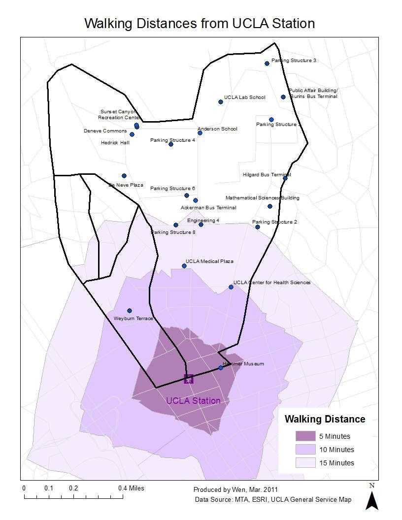
2 Introduction As the Westside Subway Extension program of Los Angeles Metro, so call purple line extension ongoing, in the future, there would be a subway station in Westwood, the future UCLA station. However, the future UCLA station would be on the Wilshire Boulevard. Assume people willingness to walk to the station is 1/4 mile to half mile. Then there is a transit problem between Wilshire Boulevard and UCLA campus. The distance between Wilshire Boulevard and UCLA main campus is about one mile and this creates a so-call Last-mile problem. Typically, bicycle is one of the solutions to solve the last-mile problem. This paper examines if bicycle could be the solution in the Westwood area, and analysis where should the public bicycle sharing station could be build? The Future UCLA Subway Station Where is the Future UCLA subway station? By the Westside Subway Extension program environmental impact report, the most possible location is on the north side of Wilshire Boulevard between Gayley and Veteran, right under UCLA parking lot 36. Map1 indicates the location of future UCLA station and the 5 minutes walking distances. From Map1, we can see that the subway station is not in walking distances from the UCLA main campus. However, the station cannot MAP 1 1

3 be build at any place near the UCLA campus either because of the huge cost making the subway line turn and the nearby cemetery. If the station is built near the UCLA; for example, on Le Conte Street, the subway line cannot avoid to go under through the cemetery and continue heading west. The Los Angeles County Metropolitan Transportation Authority (MTA) predicts the future UCLA station would be the busiest station in the whole Los Angeles Metro system. By the prediction, about 14,000 people per weekday would board at this station, and this number does not count the people who get off trains. The possible rider for the UCLA station includes people from the UCLA Medical Center, the high-rise business office building around, the nearby Federal Building and from the UCLA campus. Map 2 shows the maps of demography analysis for the possible riders near the UCLA station. The possible riders are people who live or work near UCLA. The map to the left shows the number of population who live around UCLA. And the map to the right shows the number of workers around UCLA. There are also two distance-buffers on the MAP 2 2
4 maps. The half mile buffer indicates the 10 minutes walking distances and the 1.5 mile buffer indicates the 8 to 10 minutes biking distances. population number of workers mile 1 mile 1.5 mile Figure 1 Figure 1 shows the chart of summary statistics about the population and number of workers around UCLA. We can find that the number of workers and population increase significantly from the half male buffer to the 1.5 miles buffer. That is, if a person who live or work 1.5 mile away from the station has easier access to the station, the usage of the public transit would increase. Transit Methods Analysis: Between UCLA Station and UCLA Campus From the future UCLA station; there is three quarter mile walk to Ackerman Plaza, 1 mile to Royce Hall and more than 1 mile to the UCLA Northern campus. Take the Public Affairs Building as the final destination for example. Table 1 shows the possible transit method to and from Wilshire Boulevard and The PA Building. From Table 1, we can find that using bicycle would cost 6-10 minutes to transit. Compared to other transit method, such as Public buses, school shuttle, bicycle could be one of the transit methods which save time. Also, the distance between UCLA station and the PA building is about 1.5 miles, if choose walk from the station, it would need 30 minutes to get to the final destination. Thus, the bike population should increase in the future when the UCLA subway arrive. To solve the last mile problem between UCLA subway station and UCLA campus, Public bike sharing system could a solution. 3
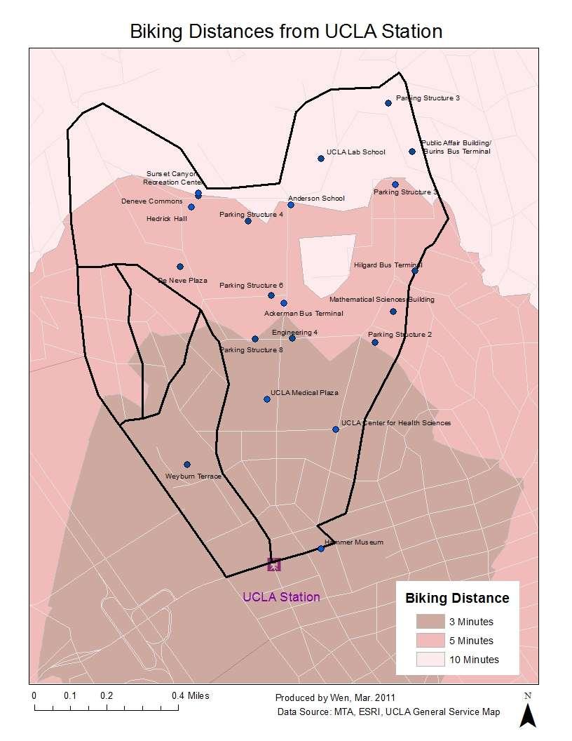
5 Table 1: The Alternative Transit Method Between UCLA Station and PA Building Transit Mode Distance (miles) Time for waiting (Bus Frequency) Transit Time Walking Time (from bus stop or parking) Total Time (Minutes) Bus (BBB1, 2, 8, 12, Metro 761) 1 to 5 minutes 5 minutes 5-8 minutes Bruin Bus 8 to 10 minutes 5 minutes 5 minutes Bicycle 1.5 None 6-10 minutes (15mph) 0-3 minutes 6-10 Walk 1.4 None 30 minutes(3mph) None 30 Drive None 5 minutes 5 minutes 10 The Public Bicycle Rental System The public rental bike system, also called smart bike program, is a system that people could rent a bike for short one-way trip. The public bike program uses an automatic management bike system; and provides a multiple locations bicycle rental service. People could unlock a bike from any bike station and put it back in any other stations in the system. Usually, users swipe their smart transit pass to unlock the bike in the stations, and after every trip, locked the bicycle back in the station near their destination. The smart bike program is now operating in big cities across world such as Paris, London, Barcelona, and Washington D.C. Walking and biking from the UCLA Station Map 3 and 4 shows map of service area analysis of the UCLA station. Map 3 shows the service area of UCLA station in 15 minutes walking distances. As we can see in the map, half of the main buildings in UCLA cannot be reached in 15 Minutes walking distances. This creates a serious last-mile problem. Half of the students and faculties can t reach the station in walking distances and will have less incentive to take the subway. Map 4 shows the service area of UCLA station in 10 minutes biking distance. From the map, we can see that the whole UCLA campus could be reached in 10 minutes biking distances, assume the biking speed is 15mph. 4
6 Map 3 5
7 Map 4 6

8 Location for the Potential Bike Stations on UCLA Campus We can predict that the bike population would increase if there is a UCLA subway station on Wilshire Boulevard. If the bike sharing system could solve the Last-mile problem, then where should we build the bike stations? Also, the bike accessibility in UCLA is also another issue. Map 5 shows the route analysis around UCLA main buildings. As we can see, bikers cannot bike through the campus directly because there are lots of stairs through south campus to north campus. Bikers only could ride around outside the UCLA campus. Map 5 7
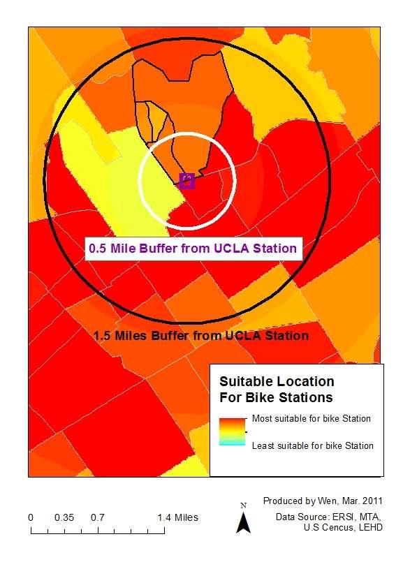
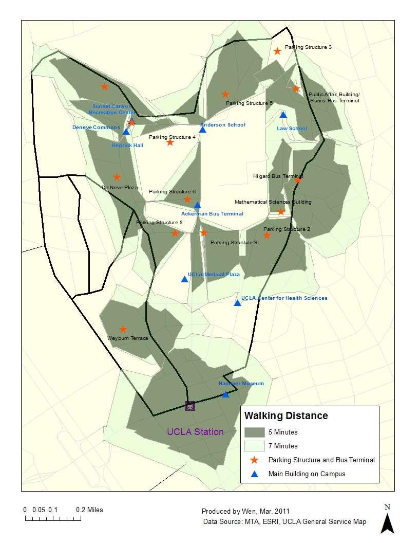
9 Next, I do the hot spot analysis. The hot spot analysis index is generated depend on the area population, the number of workers in the area, the existing number of public transit users and distance from the UCLA station. For the population, number of workers and number of transit users, higher number of people is associated with higher index score. For the distance, the score is distributed as following table: Distance mile mile miles miles 2-3 miles 3 miles and up Scores The reason of this score is that we don t want the bike station too far or too near to the UCLA station. Map 6 shows the result of hot spot analysis. From the map, we can suggest that we could start to build the bike station on the east side of UCLA. Also, set a public bike station need space. The easiest place to set a bike station is in the existing parking structure. Assume the future bike stations are set in the parking lot, Map 7 and 8 show the net work analysis of the possible bike station service area. The Map 7 indicates that the bike stations are in walking distance to the main building in UCLA. Map 8 shows that the biking distances between stations is no more than 3 minutes and almost every main building could be reached in 3 minutes by bike. However, the white spot on both net work analysis maps show that there are some no service areas on the north campus. This is because there are no bike friendly roads and also because of the data constrain. 8
10 Map 6 9
11 Map 7 10

12 No Service Area Map 8 11
13 Conclusion First of all, the bicycle population should increase if there is a UCLA subway station on Wilshire. So the public bike sharing system could be support in the future. But the existing bike lanes in UCLA still not enough, especially in north campus. Also, space for bike parking and set the bike station is still an issue. Setting the bike stations inside the existing UCLA parking structure could be a plausible solution according to the network analysis of service area. Public bike sharing system is a possible policy to solve the last-mile problem around the future UCLA subway station in the future. Data Sources: The US Census: Demography Data ESRI The United States Local Employment Dynamic Database The Los Angeles County Metropolitan Transportation Authority (MTA) 12
Westside Transportation Access Needs Assessment - Short and Long Term Improvements
 ABSTRACT The Los Angeles County Metropolitan Transportation Authority (MTA) adopted the 2001 Long Range Transportation Plan (LRTP), which sets out the County s transportation investments for the next 20-25
Cabrillo College Transportation Study
 Cabrillo College Transportation Study Planning and Research Office Terrence Willett, Research Analyst, Principle Author Jing Luan, Director of Planning and Research Judy Cassada, Research Specialist Shirley
TIMELINE OF ACHIEVEMENTS 04 INTRODUCTION 06 COMMUTER CHARACTERISTICS 08 VEHICLE TRIPS AND TRAFFIC 10 MODE SPLIT 12 COMMUTER BENEFITS 16
 TABLE OF CONTENTS December 2015 A LETTER FROM THE EXECUTIVE DIRECTOR It all started when the Olympic Games came to Los Angeles in summer 1984. With UCLA designated as an Olympic Village and host to several
Guidelines for Providing Access to Public Transportation Stations APPENDIX C TRANSIT STATION ACCESS PLANNING TOOL INSTRUCTIONS
 APPENDIX C TRANSIT STATION ACCESS PLANNING TOOL INSTRUCTIONS Transit Station Access Planning Tool Instructions Page C-1 Revised Final Report September 2011 TRANSIT STATION ACCESS PLANNING TOOL INSTRUCTIONS
Capital Bikeshare 2011 Member Survey Executive Summary
 Capital Bikeshare 2011 Member Survey Executive Summary Prepared by: LDA Consulting Washington, DC 20015 (202) 548-0205 June 14, 2012 EXECUTIVE SUMMARY Overview This report presents the results of the 2012
2016 Capital Bikeshare Member Survey Report
 2016 Capital Bikeshare Member Survey Report Prepared by: LDA Consulting Washington, DC 20015 (202) 548-0205 February 24, 2017 EXECUTIVE SUMMARY Overview This report presents the results of the November
CHAPTER 1 A 1 PURPOSE AND NEED
 CHAPTER 1 A 1 PURPOSE AND NEED The Federal Transit Administration (FTA) and the Los Angeles County Metropolitan Transportation Authority (Metro) propose the Westside Subway Extension Project (Project),
Flyaway Bus: GIS Analysis on Current and Potential Ridership, Revenue, and Prospective Stations
 ProfessorBarry Waite & Bonnie Shrewsbury Flyaway Bus: GIS Analysis on Current and Potential Ridership, Revenue, and Prospective Stations 1. Abstract The Flyaway Bus is a long distance non-stop shuttle
Transportation-Demand Management Community Presentation
 Transportation-Demand Management Community Presentation American University Office of Risk, Safety and Transportation programs Thursday, June 7, 2018 Program Objectives Improve transportation options for
Executive Summary. TUCSON TRANSIT ON BOARD ORIGIN AND DESTINATION SURVEY Conducted October City of Tucson Department of Transportation
 Executive Summary TUCSON TRANSIT ON BOARD ORIGIN AND DESTINATION SURVEY Conducted October 2004 Prepared for: City of Tucson Department of Transportation May 2005 TUCSON TRANSIT ON BOARD ORIGIN AND DESTINATION
Intermodal Connections with Light Rail in Phoenix, AZ Wulf Grote, P.E. Director, Planning & Development
 Intermodal Connections with Light Rail in Phoenix, AZ Wulf Grote, P.E. Director, Planning & Development 12th National LRT Conference Salt Lake City, UT November 12, 2012 Outline METRO Light Rail Overview
Eliminate on-street parking where it will allow for a dedicated bus only lane %
 Traffic Dashboard Priorities Survey Responses Introduction 1) Are you familiar with bus rapid transit (BRT)? a. No, BRT is new to me. 597 23.5% b. I ve heard of BRT, but I don t know much about it. 1,136
CAMPUS GUIDE TO BIKE SHARE. h o w t o p l a n a n d l a u n c h a s u c c e s s f u l u n i v e r s i t y b i k e s h a r e p r o g r a m
 CAMPUS GUIDE TO BIKE SHARE h o w t o p l a n a n d l a u n c h a s u c c e s s f u l u n i v e r s i t y b i k e s h a r e p r o g r a m 20151020 The bicycle is the most loved form of transportation. No
Bike share success factors
 Bike share success factors A guide to the types of locations where bike share can flourish January 2016 Bike share success factors A guide to the types of locations where bike share can flourish and how
Public bikesharing has emerged as one of the latest transportation
 Unraveling the Modal Impacts of Bikesharing S U S A N S H A H E E N A N D E L L I O T M A R T I N Public bikesharing has emerged as one of the latest transportation innovations, transforming North American
Tunnel Reconstruction Brooklyn CB 1 August 14, 2018
 Tunnel Reconstruction Brooklyn CB 1 August 14, 2018 Reconstructing the Tunnel 2 Service During Tunnel Reconstruction April 2019 through July 2020 3 Projected Cross River Travel Paths of Customers The Service
Demand Estimation Model for Park-and-Ride Service: Fort Bend County to Central Houston
 Demand Estimation Model for Park-and-Ride Service: Fort Bend County to Central Houston 1 Investigation of past and present methods/thoughts LITERATURE/SOURCE REVIEW RELATIVE DEMAND ESTIMATION 2 General
SNCC Demographic Trends
 Employment Population SNCC Demographic Trends In 1970 the SNCC population was 10,040, accounting for roughly 3% of the County population In 2015, SNCC grew to 60,567 people, roughly 11% of the County population
Metro Bike/Bus Interface Study
 Metro Bike/Bus Interface Study Agenda 1. Background & Process 2. Corridors & Metrics 3. General Findings 4. Training Recommendations 5. Design Guidelines 6. Questions L.A. County Bus Service LA Metro 1,433
PRINCE GEORGE S PLAZA METRO AREA PEDESTRIAN PLAN
 PRINCE GEORGE S PLAZA METRO AREA PEDESTRIAN PLAN May 28, 2008 Agenda Welcome and introductions Project overview and issue identification Planning context and strengths Design challenges and initial recommendations
Webinar- Importance of Multi- Modal Transit Connections and Fare Policy for Regional Transit Mobility & Equity
 Webinar- Importance of Multi- Modal Transit Connections and Fare Policy for Regional Transit Mobility & Equity Thomas Marchwinski Metro North RR (Previously with NJ Transit) Importance of Multi-Modal Transit
2014 Metro Transit Customer Survey Highlights
 2014 Metro Transit Customer Survey Highlights Metropolitan Council Transportation Committee - April 13, 2015 Presented by: Bruce Howard, Director of Customer Services and Marketing METHODOLOGY : Quantitative
Measuring and Communicating Mobility:
 Measuring and Communicating Mobility: The District Mobility Project Stephanie Dock, District Department of Transportation TRB Transportation Issues in Major Cities Committee May 2, 2017 Deconstructing
GOALS, OBJECTIVES, AND RECOMMENDATIONS
 GOALS, OBJECTIVES, AND RECOMMENDATIONS GOALS, OBJECTIVES, AND RECOMMENDATIONS ASSESSMENT CRITERIA Notes Status BIKES Goal 1: Increase the use of bikes as a clean and healthy method of transportation by
Bicycle Sharing (Public Bike) Li Shanshan Bradley Schroeder ITDP China 2010
 Li Shanshan Bradley Schroeder ITDP China 2010") Bicycle Sharing (Public Bike) Li Shanshan Bradley Schroeder ITDP China 2010 What is bicycle sharing (public bike) in China? A number of bicycles made available for shared use amongst individuals who do
Bicycle Sharing (Public Bike) Li Shanshan Bradley Schroeder ITDP China 2010 What is bicycle sharing (public bike) in China? A number of bicycles made available for shared use amongst individuals who do
Public Bicycle Sharing and Rental Programs 2014 Transportation Research Board Transportation and Federal Lands
 Public Bicycle Sharing and Rental Programs 2014 Transportation Research Board Transportation and Federal Lands Rebecca Gleason, PE Research Engineer Mobility & Public Transportation September, 2014 Background
2017 Florida Commuter Transportation Summit
 2017 Florida Commuter Transportation Summit Building Bicycle Friendly Universities Ron Fuller, Assistant Director Transportation and Parking Services University of Florida Achieving the Silver Level a
Los Angeles County Metropolitan Transportation Authority Metro Bicycle Roundtable
 Los Angeles County Metropolitan Transportation Authority Metro Bicycle Roundtable Metro Headquarters Tuesday, November 5, 2013 5:30 7 pm Bicycle Program History & Future Countywide Planning/ Transportation,
DON MILLS-SHEPPARD Mobility Hub Profile
 DON MILLS-SHEPPARD Mobility Hub Profile Dundas Don Mills-Sheppard West-Bloor Anchor Hub Gateway Hub N MOBILITY HUBS: Places of connectivity between regional and rapid transit services, where different
NEWMARKET CENTRE Mobility Hub Profile
 Mobility Hub Profile Dundas Newmarket West-Bloor Centre Anchor Hub Gateway Hub N MOBILITY HUBS: Places of connectivity between regional and rapid transit services, where different modes of transportation
TRANSPORTATION FACILITIES AND THEIR IMPACT ON HEALTH
 TRANSPORTATION FACILITIES AND THEIR IMPACT ON HEALTH Health and Transportation Air quality Climate change Safety Physical activity Access to food, medical care, employment Policy Link & Prevention Institute
TAC February 1, 2012 Prepared by Metro Bike Program
 Bike Share Concept Report/Strategy TAC February 1, 2012 Prepared by Metro Bike Program July 2011 Board Directive 1. Requires Metro to take a leadership role in implementing bike share in LA County. 2.
Kevin Proft NRS 509 Final Project: Written Overview & Annotated Bibliography GIS Applications in Active Transportation Planning
 Kevin Proft NRS 509 Final Project: Written Overview & Annotated Bibliography 12.13.16 GIS Applications in Active Transportation Planning Geographic Information Systems (GIS) play an important role in developing
DIRECTION REGARDING WEHO PEDALS BIKE SHARE PROGRAM AND DOCKLESS BIKE SHARE PILOT MAYOR PRO TEMPORE JOHN D' AMICO COUNCILMEMBER LAUREN MEISTER
 CITY COUNCIL DECEMBER 3, 2018 NEW BUSINESS SUBJECT: INITIATED BY: DIRECTION REGARDING WEHO PEDALS BIKE SHARE PROGRAM AND DOCKLESS BIKE SHARE PILOT MAYOR PRO TEMPORE JOHN D' AMICO COUNCILMEMBER LAUREN MEISTER
Bike-Sharing & the Built Environment
 Bike-Sharing & the Built Environment UT Austin School of Architecture s Urban Information Lab (UIL) Dr. Junfeng Jiao & Louis Alcorn Spring 2018 April 26, 2018 Big Picture: How does the built environment
Tunnel Reconstruction South 5 th Street Association October 16, 2018
 Tunnel Reconstruction South 5 th Street Association October 16, 2018 Reconstructing the Tunnel 2 Service During Tunnel Reconstruction April 2019 through July 2020 3 Projected Cross River Travel Paths of
Wilshire Boulevard Bus Rapid Transit Project
 Los Angeles County Metropolitan Transportation Authority Wilshire Boulevard Bus Rapid Transit Project COMMUNITY MEETINGS November 2008 Agenda Introduction Proposed Project Overview Participating Agencies
BEAR CREEK PARK AND RIDE
 BEAR CREEK PARK AND RIDE 7760 178th Pl NE, Redmond, WA 98052 700 Average weekday transit boardings 283 Parking spaces Owned by King County Metro Served by Sound Transit and King County Metro Bear Creek
Customer Satisfaction Tracking Report 2016 Quarter 1
 Customer Satisfaction Tracking Report 2016 Quarter 1 May 2016 Prepared by: NRG Research Group Project no. 317-15-1445 Suite 1380-1100 Melville Street Vancouver, BC V6E 4A6 Table of Contents Background
Agenda. Overview PRINCE GEORGE S PLAZA METRO AREA PEDESTRIAN PLAN
 PRINCE GEORGE S PLAZA METRO AREA PEDESTRIAN PLAN May 28, 2008 Agenda Welcome and introductions Project overview and issue identification Planning context and strengths Design challenges and initial recommendations
Washington DC Section of ITE Project Briefing
 Washington DC Section of ITE Project Briefing November 5, 2015 Renée Hamilton, VDOT, Deputy District Administrator I-66 Outside the Beltway Improvement Area Project Location Virginia 2 Purpose and Need
We're at Your Service. Parking, Transportation and Services
 We're at Your Service Parking, Transportation and Services Getting to Campus Getting Around Campus Parking Fleet Services Travel Services Mailing Services Getting to Campus Over 60% of people arrive to
Key objectives of the survey were to gain a better understanding of:
 3 COMMUNITY INPUT Community input is an essential part of corridor studies. For the SR 87 corridor study, VTA staff conducted an extensive online survey of people living and commuting along the corridor.
Strategic Plan for Active Mobility Phase I: Bicycle Mobility
 Strategic Plan for Active Mobility Phase I: Bicycle Mobility City of Corpus Christi February 9, 2016 Jeff Pollack, AICP Transportation Planning Director Vision Active Mobility Plan Vision The metropolitan
Addressing Bicycle Capacity Issues on Public Transportation
 Addressing Bicycle Capacity Issues on Public Transportation Advanced Transportation Technologies Clean Transportation Solutions SM Whitney Pitkanen Project Manager MISSION STATEMENT CALSTART is dedicated
BIKE TRANSIT INTEGRATION IN NORTH AMERICA. John Pucher & Ralph Buehler
 BIKE TRANSIT INTEGRATION IN NORTH AMERICA John Pucher & Ralph Buehler Synergies: Bicycling and Public Transport: Perfect Together? Cycling extends catchment areas of transit stops far beyond walking range
BOSTON REGION METROPOLITAN PLANNING ORGANIZATION
 PLANNING ORGANIZATIO BOSTON REGION MPO NMETROPOLITAN BOSTON REGION METROPOLITAN PLANNING ORGANIZATION Stephanie Pollack, MassDOT Secretary and CEO and MPO Chair Karl H. Quackenbush, Executive Director,
San Mateo County Comprehensive Bicycle and Pedestrian Plan
 San Mateo County Comprehensive Bicycle and Pedestrian Plan August 26, 2010 Presented to the San Mateo County BPAC by Lauren Ledbetter, Alta Planning + Design in association with: Fehr & Peers Eisen Letunic
INSIGHTS ON HOW BIKESHARING SUPPORTS URBAN DEVELOPMENT
 INSIGHTS ON HOW BIKESHARING SUPPORTS URBAN DEVELOPMENT INTRODUCTION Recent advances in mobile technology and big data analysis have enabled new opportunities to rethink how people live in and move through
The Broadway SkyTrain Extension
 The Broadway SkyTrain Extension Grandview Woodland Citizens Assembly Lon LaClaire Manager, Strategic Transportation Planning, City of Vancouver January 24, 2015 Commercial-Broadway is a Transit Crossroads
Bike Planner Overview
 Bike Planner Overview A Web-based Sketch Planning Tool for Los Angeles County presented by William E. Walter, GISP April 12, 2017 GIS-T Transportation leadership you can trust. Bike Planner Overview Guiding
DON MILLS-EGLINTON Mobility Hub Profile
 Mobility Hub Profile Dundas Don Mills-Eglinton West-Bloor Anchor Hub Gateway Hub N MOBILITY HUBS: Places of connectivity between regional and rapid transit services, where different modes of transportation
Presentation Comments and Questions
 Presentation Comments and Questions The community had a number of questions regarding the master plan process and operational issues in and around the MARC rail station areas. The bullet points below are
Sustainable Transportation Plan Draft 4/24/2012
 Sustainable Transportation Plan 2011-2012 Draft 4/24/2012 Contents I. Purpose... 3 II. Background... 3 III. Recent Accomplishments... 6 IV. Anticipated Changes... 8 V. Planning Process... 8 VI. Priorities...
304B Gordon- TTU Lubbock, TX April 6 th, 2011 Mr. Tyler Patton Office of the President 4952 Matador Avenue Lubbock, TX Dear Tyler Patton:
 304B Gordon- TTU Lubbock, TX 79406 April 6 th, 2011 Mr. Tyler Patton Office of the President 4952 Matador Avenue Lubbock, TX 79413 Dear Tyler Patton: Congratulations on your election as President of SGA!
TRANSPORTATION & ACCESS
 STATE OF CENTER CITY PHILADELPHIA TRANSPORTATION & ACCESS Matt Stanley Center City is well-positioned at the center of an extensive, multi-modal transportation system. It is located just seven miles from
Table #6 VISION CHARACTERISTICS
 Table #6 VISION White Flint is a place to live, work, play, shop, and walk with sufficient density to encourage quality redevelopment. Vibrant streets and consistent streetscapes are important. CHARACTERISTICS
Parking & Transportation Update Spring Parking
 Parking & Transportation Update Spring 2018 As the beginning of the Spring 2018 semester rapidly approaches, Mason students, faculty and staff are reminded that traffic on and around the Fairfax campus
SANTA MONICA BOULEVARD CORRIDOR
 CIRCULATION ELEMENT WHITE PAPER NO. 3 SANTA MONICA BOULEVARD CORRIDOR INTRODUCTION From the 1930s to the beginning of Los Angeles freeway era, Santa Monica Boulevard, (previously Route 66, the Beverly
EXECUTIVE SUMMARY... vii 1 STUDY OVERVIEW Study Scope Study Area Study Objectives
 Contents EXECUTIVE SUMMARY... vii 1 STUDY OVERVIEW... 1-1 1.1 Study Scope... 1-1 1.2 Study Area... 1-1 1.3 Study Objectives... 1-3 2 EXISTING CONDITIONS... 2-1 2.1 Existing Freeway Conditions... 2-4 2.1.1
Bicycle Count Corner of 116th Street & Broadway Manhattan, New York City
 Bicycle Count Corner of 116th Street & Broadway Manhattan, New York City Carried out on Monday, 19 November 212 Created by Annalisa Liberman (SIPA student) and Jonas Hagen (GSAPP student), for: PLAN 69
North Coast Corridor:
 North Coast Corridor: Connecting People, Transportation & Environment Legislative Hearing: 11.8.10 1 North Coast Corridor Region s Lifeline A Regional Strategy Mobility, Economy & Environment North Coast
CHAPTER 3. Transportation and Circulation
 CHAPTER 3 Transportation and Circulation 3.0 TRANSPORTATION AND CIRCULATION This chapter evaluates traffic circulation, transit, parking, pedestrian, bicycle, and rail operational conditions in the Project
CITY OF LOS ANGELES INTER-DEPARTMENTAL CORRESPONDENCE SUBJECT: UPDATE ON DODGER STADIUM SHUTTLE SERVICE FOR THE 2009 BASEBALL SEASON (CF )
") CITY OF LOS ANGELES INTER-DEPARTMENTAL CORRESPONDENCE Date: January 14, 2009 To: The Honorable City Council C/o City Clerk, Room 395, City Hall Attention: Wendy Greuel, Chair Transportation Committee From:
CITY OF LOS ANGELES INTER-DEPARTMENTAL CORRESPONDENCE Date: January 14, 2009 To: The Honorable City Council C/o City Clerk, Room 395, City Hall Attention: Wendy Greuel, Chair Transportation Committee From:
TRANSPORTATION & MOBILITY
 TRANSPORTATION & MOBILITY ROADWAY SYSTEM There are approximately 40 miles of roadways in Manitou Springs. For planning purposes, roadways are typically assigned a functional classification which defines
NORTH YORK CENTRE Mobility Hub Profile
 Mobility Hub Profile Dundas North York West-Bloor Centre Anchor Hub Gateway Hub N MOBILITY HUBS: Places of connectivity between regional and rapid transit services, where different modes of transportation
Typical Rush Hour Commute. PennyforTransportation.com
 Typical Rush Hour Commute In the News Overview of the Plan Collaborative plan with projects in every community Prioritizing connectivity and congestion relief Dedicated transportation-specific funding;
Bellevue Transportation: Challenges, Opportunities and Priorities Bellevue Downtown Association September 20, 2018
 Bellevue Transportation: Challenges, Opportunities and Priorities Bellevue Downtown Association September 20, 2018 Dave Berg Transportation Director City of Bellevue Traffic, traffic and more traffic!
Fitting Light Rail through Well-established Communities
 Fitting Light Rail through Well-established Communities San Francisco 2008 Michael D. Madden Chief, Project Development, Maryland Transit Administration Project Setting Located inside the Capital Beltway
WESTSIDE EXTENSION TRANSIT CORRIDOR STUDY Project No. PS Task 3.4 Final Initial Alternatives Screening Report (20c) Prepared for:
 Prepared for:") WESTSIDE EXTENSION TRANSIT CORRIDOR STUDY Project No. PS-4350-2000 Task 3.4 Final Initial Alternatives Screening Report (20c) Prepared for: Prepared by: Parsons Brinckerhoff 444 South Flower Street Suite
WESTSIDE EXTENSION TRANSIT CORRIDOR STUDY Project No. PS-4350-2000 Task 3.4 Final Initial Alternatives Screening Report (20c) Prepared for: Prepared by: Parsons Brinckerhoff 444 South Flower Street Suite
Air pollutants exposure while commuting in the Greater Paris Area
 Air pollutants exposure while commuting in the Greater Paris Area Sophie Moukhtar Airuse Life Conference - 27/09/2017 Summary 1. Commuting in Paris 2. Pollution exposure while commuting 3. Interactive
395 Express Lanes Extension
 395 Express Lanes Extension January 2016 Building a network of Express Lanes Project overview Add capacity on I-395 with addition of a third HOV lane and active traffic management Generate guaranteed transit
Midtown Corridor Alternatives Analysis
 Midtown Corridor Alternatives Analysis Ridership Forecast Methodology and Results December 2013 Prepared by the SRF Consulting Group Team for Table of Contents Introduction... 1 Methodology... 1 Assumptions...
Benefits for the Bronx, Brooklyn, Queens and Staten Island
 Congestion Pricing for New York: Benefits for the Bronx, Brooklyn, and Staten Island Prepared for the Coalition for Traffic Relief April 007 Schaller Consulting 94 Windsor Place, Brooklyn, NY (78) 768-3487
Roads and Vehicular Traffic Design Principles. Roads and Vehicular Traffic Recommendations
 CIRCULATION AND PARKING roads and vehicular traffic The Campus Master Plan updates the campus transportation network through a multi-modal approach that encourages walking and biking while improving vehicular
Copyright by Home by School.com (Third Conversion, LLC). All rights reserved. Published by Third Conversion, LLC
. All rights reserved. Published by Third Conversion, LLC") Copyright 2010-2012 by Home by School.com (Third Conversion, LLC). All rights reserved. Published by Third Conversion, LLC No part of this publication may be reproduced or transmitted in any form or by
Copyright 2010-2012 by Home by School.com (Third Conversion, LLC). All rights reserved. Published by Third Conversion, LLC No part of this publication may be reproduced or transmitted in any form or by
Capital and Strategic Planning Committee. Item III - B. April 12, WMATA s Transit-Oriented Development Objectives
 Capital and Strategic Planning Committee Item III - B April 12, 2018 WMATA s Transit-Oriented Development Objectives Page 24 of 76 Washington Metropolitan Area Transit Authority Board Action/Information
Bikestation. Connecting Cyclists with Transit
 Bikestation www.bikestation.org Connecting Cyclists with Transit Brand 05 Railvolution: Last Mile Workshop 2 Mission Bikestation is a non-profit organization that seeks to improve the quality of life in
Fiscal Year Big Blue Bus Year End Performance Report
 Information Item Date: October 25, 2016 To: From: Subject: Mayor and City Council Edward F. King, Director of Transit Services Fiscal Year 2015-16 Big Blue Bus Year End Performance Report Introduction
Making Dublin More Accessible: The dublinbikes Scheme. Martin Rogers Colm Keenan 13th November 2012
 : The dublinbikes Scheme Martin Rogers Colm Keenan 13th November 2012 Modal Splits for Dublin 2001-2011 Dublin Mode Share Summary - Persons Crossing Canal Cordon 07.00-10.00 Year Total All PT % Car % Walk
Bus Rapid Transit Plans
 Twin Cities Region Bus Rapid Transit Plans ULI Minnesota Workshop Connecting Bus Rapid Transit to the Community December 15, 2009 John Levin Director of Service Development Metro Transit Metropolitan Area
CASE STUDY City of Monrovia: Leveraging emerging ridesharing services to expand mobility options
 Advancing Mobility Management CASE STUDY City of Monrovia: Leveraging emerging ridesharing services to expand mobility options Agency: Location: Service Area: Modes: Community Context: Key Contacts: City
Planning Suburban Bike Networks
 Planning Suburban Bike Networks Stacey Meekins, AICP 28 October, 2015 Bikeway design guidance Different Cyclists Have Different Needs No interest 33% Strong and Fearless 1% Enthused and Confident 7% Interested,
Rail Station Fact Sheet CentrePort/DFW Airport Station
 Rail Station Fact Sheet CentrePort/DFW Airport Station Station Overview CentrePort/DFW Airport Station is located by Statler Boulevard at Breezewood Drive in Fort Worth. Free shuttles connect the station
CHAPTER 3: Vision Statement and Goals
 Davidson Walks & Rolls: Active Transportation Master Plan CHAPTER 3 Contents: Overview Vision Statement Measurable Goals Public Outreach CHAPTER 3: Vision Statement and Goals Overview The vision statement
Seoul Transportation. March Urban Transportation Division Seoul Metropolitan Government
 Seoul Transportation March 2016 Urban Transportation Division Seoul Metropolitan Government Conte nts Ⅰ. Pa st & Now 3 Ⅱ. Vision 1 5 Ⅲ. Imple me nta tion 1 9 Ⅰ. Pa st & Now 1. Pa st & Now Seoul transportation
MTA Surveys: Facts and Findings. NYMTC Brown Bag March 12, 2014 Julia Seltzer, MTA Planning
 MTA Surveys: Facts and Findings NYMTC Brown Bag March 12, 2014 Julia Seltzer, MTA Planning MTA Planning Survey Program Why survey? Who was surveyed? Challenges Methodologies Findings Uses for data 1 Why
Transportation Trends, Conditions and Issues. Regional Transportation Plan 2030
 Transportation Trends, Conditions and Issues Regional Transportation Plan 2030 23 Regional Transportation Plan 2030 24 Travel Characteristics Why Do People Travel? Over one-half of trips taken in Dane
Advanced Materials Research Vol
 Advanced Materials Research Online: 2013-09-04 ISSN: 1662-8985, Vol. 790, pp 510-514 doi:10.4028/www.scientific.net/amr.790.510 2013 Trans Tech Publications, Switzerland Public bicycle System Station Deployment
Urban planners have invested a lot of energy in the idea of transit-oriented
 DOES TRANSIT-ORIENTED DEVELOPMENT NEED THE TRANSIT? D A N I E L G. C H AT M A N Urban planners have invested a lot of energy in the idea of transit-oriented developments (TODs). Developing dense housing
Transit With Bikesharing: Overview of Practice and Potential March 14, 2012
 Transit With Bikesharing: Overview of Practice and Potential March 14, 2012 Darren Buck FTA Office of Research, Demonstration and Innovation (on detail) Why? First/ last mile trip importance Avoid line
Presentation Summary Why Use GIS for Ped Planning? What Tools are Most Useful? How Can They be Applied? Pedestrian GIS Tools What are they good for?
 1 2 Pedestrian GIS Tools What are they good for? Pro Walk / Pro Bike 2006 Presentation Summary Why Use GIS for Ped Planning? What Tools are Most Useful? How Can They be Applied? Matt Haynes Fehr & Peers
EL CAMINO REAL BUS RAPID TRANSIT (BRT) PROJECT
 PROJECT") Agenda Item #4.2 EL CAMINO REAL BUS RAPID TRANSIT (BRT) PROJECT VTA BOARD WORKSHOP MAY 1, 2015 ABOUT THIS PRESENTATION CONTEXT Existing conditions and planning for growth WHAT IS THE PROJECT? Project alternatives
Agenda Item #4.2 EL CAMINO REAL BUS RAPID TRANSIT (BRT) PROJECT VTA BOARD WORKSHOP MAY 1, 2015 ABOUT THIS PRESENTATION CONTEXT Existing conditions and planning for growth WHAT IS THE PROJECT? Project alternatives
92% COMMUTING IN THE METRO. Congested Roadways Mode Share. Roadway Congestion & Mode Share
 COMMUTING IN THE METRO Roadway Congestion & Mode Share The majority of major roadways in Greater Des Moines are without congestion and have underutilized capacity. This surplus capacity could be used for
Changing Commuting Patterns and Impacts on Planning & Infrastructure. William E. Frawley, AICP Texas A&M Transportation Institute October 3, 2013
 Changing Commuting Patterns and Impacts on Planning & Infrastructure William E. Frawley, AICP Texas A&M Transportation Institute October 3, 2013 Change is Constant... Various studies and data sources 1960
An Incentive-Based Approach to Curbing Automobile Use in the Washington, DC Metropolitan Area
 An Incentive-Based Approach to Curbing Automobile Use in the Washington, DC Metropolitan Area Emily Freimuth Daniel Selden Andrew Kimmel Brendan Shera The Problem Urban Sprawl Increased Commuting from
Purpose and Need. Chapter Introduction. 2.2 Project Purpose and Need Project Purpose Project Need
 Chapter 2 Purpose and Need 2.1 Introduction The El Camino Real Bus Rapid Transit (BRT) Project (Project) would make transit and other transportation improvements along a 17.6-mile segment of the El Camino
ALTERNATIVES ANALYSIS EXECUTIVE SUMMARY
 West Valley Connector Corridor ALTERNATIVES ANALYSIS EXECUTIVE SUMMARY FINAL September 2014 Ontario International Airport Ontario Mills Rancho Cucamonga Metrolink Station Kaiser Permanente PARSONS EXECUTIVE
Transit Choices December 8, 2016
 Transit Choices December 8, 2016 Agenda 1. Network Redesign Status 2. Public Hearings & Bus Stops 3. Public Education Plan 4. Capital Projects Update 1 st Draft Winter Outreach October 2015 February 2016
Transit Priority. Peter G Furth
 Transit Priority Peter G Furth Fourth in a series of Policy Briefings to Boston City Council s Committee on Parks, Recreation, & Transportation Feb 2, 2017 What Does Transit Priority Look Like? Zurich