UNIVERSITY OF WASHINGTON burke-gilman trail CORRIDOR STUDY
|
|
|
- Leona Lloyd
- 6 years ago
- Views:
Transcription

1 UNIVERSITY OF WASHINGTON burke-gilman trail CORRIDOR STUDY July 2011 \\fpse2\data2\2010projects\se _bu
2
3 UNIVERSITY OF WASHINGTON BURKE-GILMAN TRAIL CORRIDOR STUDY TABLE OF CONTENTS i TABLE OF CONTENTS Executive Summary... 1 Part I - Background and Policy Guidance... 5 Scope of Study Background Burke-Gilman History Policy Guidance UW Campus Master Plan - Montlake/SR 520 Bike Path Part II - Study Framework Part V - Trail Design A Note About Trees Conceptual Approaches Spatial Implications of Trail Design Approaches Recommended Approaches for Trail Segments Trail Surface Wayfinding Trail Landscape Lighting Other Design Elements Part III - Current Conditions Trail Segments Intersections Trail Counts Bicycle Volumes Pedestrian Volumes Comparison to Previous Counts Future Year Forecasts Potential Conflict Points Part IV - Level of Service Evaluation LOS Analysis Levels of Service SUPLOS Results Shared Use Path LOS By Segment Shared Use LOS Conclusions Pedestrian LOS Conclusions Application of SUPLOS Methodology to Analysis of Proposed Bicycle Facility Width Comparison to Other Trails Part VI - Intersection Design Motorized Intersections Approaches Recommendations Non-Motorized Intersections Approaches Major Non-Motorized Intersections Traffic Control Recommendations Minor Non-Motorized Intersections Part VII - Unit Cost Estimates and Phasing Unit Costing Estimates Phasing Implementation Guidance Appendices A. Trail Plan UNIVERSITY OF WASHINGTON SvR DESIGN COMPANY JULy, 2011
4
5 UNIVERSITY OF WASHINGTON BURKE-GILMAN TRAIL CORRIDOR STUDY EXECUTIVE SUMMARY 1 EXECUTIVE SUMMARY This planning study for the Burke-Gilman Trail (Trail) on the University of Washington (UW) campus reflects a growing awareness of the increasing role the Trail plays as a regional, municipal and campus transportation facility. Many changes have occurred on the UW campus since the Trail opened in 1974, and significant changes are coming to the Trail in the immediate future. These include development of the University LINK Light Rail station at Husky Stadium, UW Montlake Triangle, reconstruction of the Stadium itself, and construction of a new SR 520 Lake Washington Floating Bridge with a regional trail linking to Montlake Boulevard. City of Seattle plans envision a tripling of bicycle traffic city-wide by 2030, and the Trail is likely to remain a key linkage in the system that will experience this growth. Changes in transportation service to the Montlake Triangle will change how pedestrians and bicyclists use the Trail to access a variety of campus destinations, as well as serve to provide a regional multi-modal connection to many destinations in the Seattle area. The purpose of this study is to analyze current conditions on the Trail, define appropriate Levels Of Service (LOS) and growth projections to 2030, and based on this information provide recommendations for improvements. Depending on the existing conditions adjacent to the Trail, UW may choose to reduce the recommended LOS at particular sections. The study acknowledges that these recommendations must also take into consideration overall aesthetic and landscape values associated with the unique setting of the Trail and the University. Phase III: Trail improvements north of Hec Edmundson (Hec Ed) Bridge and west of 15th Avenue NE, including widening to 8 pedestrian path width and 12 bicycle path width, and any necessary right-of-way assignment revisions at Pend Oreille Road. Phase IV: Revisions to right-of-way assignments at Brooklyn Avenue NE. This study acknowledges that improvements to the Trail may need to be implemented in conjunction with projects. However, this study recommends that a 20-foot buffer on either side of the existing Trail centerline be preserved to accommodate future changes to Trail width and alignment, and allow for connections to adjacent edge conditions. Where adjacent development occurs, grading within this buffer area should be done to create a maximum of 2% slope. Ultimately, the planning level concepts presented in this document reflect a minimum LOS of C for pedestrians (assuming pulsing loads) and a minimum LOS of B for bicycles. Recommended Trail improvements include separation of bicycle and pedestrian users, with 8 to 10 pedestrian path width and 12 to 14 bicycle path width to accommodate anticipated growth in pedestrian and bicycle volumes. The full build-out separated Trail width would be 28 to 29 in congested areas between 15th Avenue NE and the Hec Ed Bridge and 24 west of 15th Avenue NE and north of the Hec Ed Bridge. Pend Oreille Rd This study recommends separation of pedestrian and bicycle traffic, traffic calming and management at key intersections (including right-ofway assignment revisions at Pend Oreille Road and Brooklyn Avenue NE), and improved access and mobility. Recommendations for general phasing and prioritization of design elements are: Phase I: Widening of the Trail to 10 pedestrian path width and 14 bicycle path width and vertical separation of the Trail between T-Wing Overpass and Hec Ed Bridge. Work in this section of the Trail should be done in collaboration with the Montlake Triangle Improvement Project. Phase II: Widening of the Trail to 10 pedestrian path width and 14 bicycle path width with horizontal separation (1 -wide divider) between T-Wing Overpass and 15th Avenue NE. Work should be done in anticipation of LINK light rail patrons. Context Map University Bridge Brooklyn Ave NE 15th Ave NE T-Wing Overpass Rainier Vista Montlake Triangle Hec Ed Bridge Univ UNIVERSITY OF WASHINGTON SvR DESIGN COMPANY JULy, 2011
6
7 part i BACKGROUND AND policy guidance
8
9 UNIVERSITY OF WASHINGTON BURKE-GILMAN TRAIL CORRIDOR STUDY PART I: BACKGROUND AND POLICY GUIDANCE 5 SCOPE OF STUDY The scope of the University of Washington Burke-Gilman Trail Corridor Study (the Study) is to develop a conceptual plan proposal for the portion of the Burke-Gilman Trail (the Trail) that passes through the University of Washington s Seattle campus from Pasadena Place NE to NE 47th Street. This study is intended to address conceptual design issues relating to both existing conditions on the Trail through the University of Washington campus, and to anticipate operational changes resulting from 1) Link Light Rail service to the University, 2) new West Campus student housing facilities; and 3) a new regional trail along a rebuilt SR-520 from the Eastside to Seattle via Montlake Boulevard NE and associated park at the Bryant Building (see Figure 1). The study is timed to coordinate with these major capital transportation projects in order to ensure the Trail is designed to be an integral element of a modern, comprehensive transportation system while also respecting the campus setting and unique requirements. The study uses traffic volume measurements and projections, as well as level of service (LOS) modeling as a foundation for a concept design that will maximize safety and efficiency for anticipated user growth, while addressing aesthetic and campus identity concerns. The University of Washington (UW) has outlined the following design objectives for this study: WEST CAMPUS HOUSING PEND OREILLE IMPROVEMENTS Accommodate demonstrated and forecasted growth in trail use by bicyclists and pedestrians; Design the future Trail to accommodate the transportation function (campus and regional); Improve lighting and wayfinding using best practices; Meet or exceed current (including proposed AASHTO) design guidelines; Identify and address conflict areas between user groups and other traffic; Reinforce the UW identity via landscape design and wayfinding; Develop design alternatives that incorporate Low Impact Development (LID) principles; Improve safety by separating bicycles and pedestrians in high volume areas; and Evaluate multiple intersection concepts for their ability to reduce conflicts and bicycle speed BRYANT BUILDING RAINIER VISTA / MONTLAKE TRIANGLE FOR LINK STATION W Universit Cam A 520 EXPANSION AND NEW TRAIL Figure 1. Major Development Projects Impacting the Burke-Gilman Trail UNIVERSITY OF WASHINGTON LINK LIGHT RAIL STATION UNIVERSITY OF WASHINGTON SvR DESIGN COMPANY JULy, 2011

10 6 UNIVERSITY OF WASHINGTON BURKE-GILMAN TRAIL CORRIDOR STUDY PART I: BACKGROUND AND POLICY GUIDANCE Figure 2. Opening Day Excursion on the Seattle Lake Shore and Eastern Railroad, site of the future Burke-Gilman Trail, c BACKGROUND Through the years, the Burke-Gilman Trail has become a cherished city and regional amenity. It serves a variety of users, including commuting bicyclists, recreational cyclists, students, pedestrians, runners and skaters. It is also a nationally recognized symbol of the value of preserving abandoned rail corridors for public use. Use of the Trail has grown over the years, yet while the campus community and transportation networks surrounding the Trail have been evolving to manage this growth, the Trail itself has not kept pace. There have been efforts to improve regional access to the Trail and to accommodate growing numbers of users; however, the Trail s oldest sections (including the segment through the UW campus) remain built to the guidelines established when the Trail first opened in 1974, almost 40 years ago. Today, the challenges of this region s growth and urbanization have led to a commitment to find effective and efficient means beyond automobiles to move people. Public perceptions of the importance of walking and bicycling for both transportation and health have driven a dramatic increase in the planning and implementation of bicycling and walking projects in the last 30 years. Non-motorized transportation has become a central component of transit planning; Federal transportation funding policy now requires the consideration of bicycle and pedestrian access and mobility. The new Sound Transit Link station at Husky Stadium (the University of Washington Link Station), expanded UW West Campus housing, and the development of a new regional trail alongside the rebuilt SR-520 along Montlake Boulevard NE will place new pressures on the Trail to accommodate commuters moving to and from the UW campus, within campus, and through the campus to other destinations. When originally conceived, the Trail was a parks facility; today it is a vital part of a campus, local and regional transportation network. Burke-Gilman History (SDOT/Friends of the Burke-Gilman) Born as a Railroad In 1885 Judge Thomas Burke, Daniel Gilman and ten other investors set out to establish a Seattle-based railroad so that the then-young City might win a place among major West Coast transportation centers and reap the economic benefits of trade. Their plan was to start along today s Burke-Gilman Trail route and go north to Sumas and connect with the Canadian Transcontinental line. Their Seattle, Lake Shore and Eastern Railroad, though it never got past Arlington, Washington, was a major regional line serving Puget Sound logging areas. The line was acquired by Northern Pacific in 1913 and continued in fairly heavy use until The Great Northern, Northern Pacific, and Burlington lines were merged in 1970 to become Burlington Northern Railroad. In 1971 Burlington Northern applied to abandon the line. From Rail to Multiple Use Trail Citizens quickly recognized the non-motorized transportation and recreational potential in the railroad line and launched a movement to acquire the right-of-way for a public biking and walking trail. Objections from residents living near the proposed trail were overcome and the City of Seattle, the University of Washington and King County cooperated in developing the route. Short sections of the trail were developed starting in 1974, and dedication of the original 12.1 miles of the trail connecting Seattle s Gas Works Park and King County s Tracy Owen Station in Kenmore occurred on August 19, The trail was subsequently extended west through Seattle s Fremont neighborhood to Eighth Avenue NW and later to 11th Avenue NE. Planning and design continues for the Trail to reach its western terminus at Golden Gardens Park in Ballard. Beyond Seattle, the Burke-Gilman Trail has served to establish the viability of rail-to-trail nationally, and is the backbone of the King County Regional Trail System. North and east of the campus, the Trail reaches through Bothell, and Woodinville to Redmond by means of the Sammamish River Trail, and continues south to Issaquah via the East Lake Sammamish Trail. Future connections will link the trail network to Snoqualmie Pass in what is collectively known as the Sound to Mountains Trail. Source: Burke-Gilman Trail History, JULy, 2011 UNIVERSITY OF WASHINGTON SvR DESIGN COMPANY
11 UNIVERSITY OF WASHINGTON BURKE-GILMAN TRAIL CORRIDOR STUDY PART I: BACKGROUND AND POLICY GUIDANCE 7 Policy Guidance The Burke-Gilman Trail has been referenced many times in UW, local and regional planning efforts over the years. This section summarizes the planning and design policies relevant to the Trail and how the Trail supports these polices. UW Campus Master Plan (2003) The UW Campus Master Plan guides all conservation and development on campus, including zoning, design and development standards, transportation and circulation. The plan is required by the 1998 City- University Agreement which continues the Major Institution Overlay district that assigns certain planning and development decisions from the City of Seattle (the City) to the UW. The Campus Master Plan has the following goals to support the UW s mission: Respect Stature The Campus Master Plan should honor the status of the campus as a national treasure, a work of art, and a triumph of environmental design, enriching life with a harmonious marriage of space, form and participation. Ensure Stewardship The Campus Master Plan should ensure good stewardship of the existing campus, maintaining and protecting the value of the University s physical resources and character, history, architecture and open space. Changes to the campus should improve and enhance, rather than detract from, the value and quality of the campus. The Campus Master Plan identifies and encourages preservation of historic resources and open space. Provide Facilities The Campus Master Plan should provide for the facility and infrastructure needs of the next decade. Maximize Flexibility The Campus Master Plan should provide the maximum amount of flexibility in order to best accommodate future growth and take advantage of unforeseen opportunities. Enhance the Campus The Campus Master Plan should create an aesthetic quality appropriate to the campus as a whole and to specific areas, conserving and improving existing buildings, open spaces, and views on campus, and looking for opportunities to create additional open spaces. Provide Accessibility The Campus Master Plan should ensure access to and within the campus, maximizing and promoting non-motorized vehicular travel, emphasizing pedestrian routes for all pedestrians, and promoting the design of environments to be usable by all people, to the greatest extent possible, without the need for special arrangements or adaptations. Promote Safety The Campus Master Plan should help create a safe and healthy environment, with personal and workplace safety considerations integral to planning and design of circulation elements, buildings, and open spaces. Respect the Environment The Campus Master Plan should value the environment and strive to promote the conservation of natural resources and goals of the Growth Management Act and Shoreline Management Act. Encourage Efficiency The Campus Master Plan should encourage efficiency and economy in University operations, with advantageous locations for facilities and advantageous adjacencies of uses. Value the Community The Campus Master Plan should recognize the importance of the surrounding communities and strive to achieve compatible working relationships with these communities to improve the quality of life and public benefits for all in the vicinity. The Trail supports all of these goals. As an early example of a rails-totrails project, the Trail itself is a national treasure. Because it passes through many sections of the campus with differing landscape design styles, the Trail s design can support a cohesive campus identity. The Trail s design also provides opportunities for conserving the environment and demonstrating the UW s commitment to sustainability and low impact development (LID). The Trail is a key circulation infrastructure feature within campus and between the UW and the rest of the region. Consequently, its improvement and maintenance supports efficiency, flexibility and accessibility for UW, the City and the region. Transportation and Circulation Objectives The Campus Master Plan s transportation and circulation objectives require the UW to ensure access to and within the campus by all modes of transportation, maximizing non-vehicular travel and encouraging a safe and pleasant environment for pedestrians and bicyclists. The UW s specific objectives include: Improve the pedestrian experience on campus; Increase access for pedestrians and bicyclists, both to and within the campus; Minimize conflicts between pedestrians, bicycles, and vehicles; Improve public transportation with the goal of minimizing vehicle trips to campus and related parking requirements; provide safe, convenient access for pedestrians to and from public transportation; Minimize the amount of new parking facilities while still providing parking for the variety of users on campus, including the disabled, with the least impact on the campus and the surrounding street system with particular care to street systems that are contiguous with residential neighborhoods; Maintain the cap of 12,300 parking stalls; Locate, landscape, and screen parking to prevent detracting from the overall quality of the campus environment while promoting safety and security; and Clearly identify entries into campus and improve signage around campus. UNIVERSITY OF WASHINGTON SvR DESIGN COMPANY JULy, 2011

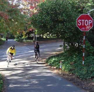
12 8 UNIVERSITY OF WASHINGTON BURKE-GILMAN TRAIL CORRIDOR STUDY PART I: BACKGROUND AND POLICY GUIDANCE General Circulation Policies The Campus Master Plan s General Circulation Policies include general design policies specific to pedestrian and bicycle facilities. As will be discussed later in this Study, while the Trail meets many of these design guidelines in some fashion, increased use of the Trail and growth on campus and beyond have pushed it to, and in some places above, its capacity. Anticipated future growth will only exacerbate the Trail s decreasing ability to meet both campus and regional transportation needs. UW s investment in a thoughtful redesign of the Trail now will allow it to provide improved service to the UW population and the region for the foreseeable future. Pedestrian Pathways Directly connect campus pedestrian routes to major external routes to facilitate commuting by walking. Generally align to serve origins and destinations as directly as possible. Facilitate finding one s way around campus by providing sight lines to destinations, intermediate places, and major landmarks from which a person can comprehend their relative location. Establish pathway widths adequate for unimpeded passage during peak pedestrian volumes. Widths must be a minimum of 6 feet wide and unobstructed with appurtenances, whether sidewalks are along streets or separated. Minimize conflicts with vehicles, service, and bicycles. Separate as much as feasible. All major pedestrian pathways will be well lighted to promote after-dark pedestrian travel on those paths. Surfaces should be nonslip, especially when wet; they should also drain well. Accommodate changing pedestrian circulation needs resulting from light rail entrance locations and related volume increases. Wherever possible, provide accessible grades. Where different travel modes intersect, incorporate design elements which provide clear distinction of right-of-way: -- Continue UW crosswalk marking standard on major roadways scored, tinted concrete paving tiles with reflective white markers on the side. -- Where driveways and service roads intersect with major roadways, maintain constant sidewalk elevation, providing driveway apron to bring vehicles up to sidewalk level. -- Pedestrian walks within service roads should be well marked. -- Provide texture distinction. Light Stevens Way and Columbia Road to 2.0 foot candles (fc) (20 LUX). At high-use pedestrian entrances to the campus, provide gateway features that announce entrance. At these and high volume internal crossings, provide appropriate signage and maps. Provide covered pathways by openings or walkways through buildings or colonnades on buildings. Provide enhanced pedestrian linkages across 15th Avenue NE into the University District at NE 45th Street, NE 43rd, NE 41st Street and NE 40th Street, especially at light rail stations and through the Hospital and Health Sciences complex and in the vicinity of the University Bridge and Campus Parkway. Bicycle Pathways Directly connect campus bicycle routes to external routes to facilitate commuting by bike, particularly in the vicinity of the University Bridge/Campus Parkway. Place and sign pathways so as to avoid conflicts with pedestrian circulation. Restrict circulation in most dense pedestrian areas within the Central Campus. Work with City to establish external routes and improve interfaces/continuity with internal routes. Establish bike routes on vehicular and service roads where possible, rather than on pedestrian pathways. Pursue additional bicycle routes to, and possible through and into, the heart of Central Campus if ways can be found to avoid pedestrian-bicycle conflicts. Dedicated bike lanes should be established on the uphill grades of vehicular roadways (specifically at Pend Oreille Road and 40th). Secure, covered bicycle storage will be provided with each new building project. Locate near entrances so as not to conflict with pedestrian access. If bicycle lockers are included, place as out of sight as possible (while still providing access) to avoid conflict with the landscape or buildings. Figure 3. Mixed traffic conditions on Burke-Gilman Trail at Hec Edmundson Bridge JULy, 2011 UNIVERSITY OF WASHINGTON SvR DESIGN COMPANY
13 UNIVERSITY OF WASHINGTON BURKE-GILMAN TRAIL CORRIDOR STUDY PART I: BACKGROUND AND POLICY GUIDANCE 9 Seattle Department of Transportation (SDOT) Urban Trails and Bikeways System The City of Seattle views multi-purpose trails as both a transportation and a recreational amenity. The City addresses the role of trails in a number of different policy arenas, including the Bicycle Master Plan and the creation of the Urban Trails and Bikeways System. The Urban Trails and Bikeways System was originally adopted as the Urban Trails System in SDOT s 2005 Transportation Strategic Plan. There are four major goals for the system: Facilitate bicycling as a viable transportation choice; Afford citizens the opportunity to experience the City s unique scenic and natural amenities; Provide access to healthful recreational activities; and Link major parks and open spaces with Seattle neighborhoods. City of Seattle Bicycle Master Plan Adopted in 2007, the Bicycle Master Plan provides specific policy guidance and direction for accommodating the growing demand for safe bicycle access throughout the City. The plan s two primary goals are ambitious: Goal 1: Increase use of bicycling in Seattle for all trip purposes. Triple the amount of bicycling in Seattle between 2007 and Goal 2: Improve safety of bicyclists throughout Seattle. Reduce the rate of bicycle crashes by one third between 2007 and The plan seeks to add 38 to 58 additional miles to the system by 2017, which would expand the Urban Trails and Bikeways System by almost one-third. UW Campus Master Plan (2003) Transportation Management Plan The Transportation Management Plan is an integral element of the 2003 Campus Master Plan. It spells out specific actions and strategies designed to guide implementation of the Campus Master Plan s transportation vision and goals. The Transportation Management Plan was last updated in It summarized existing bicycling and pedestrian conditions and listed the following needed improvements: Bicycling The University of Washington currently supplies bicyclists with multiple locations for securing and storing their bicycles on campus. The University has the largest inventory of bike lockers in the nation. Clothes lockers and showers are available at some campus locations for students, staff, and faculty. Bike lockers can be rented for a small fee on a quarterly basis; many have a waiting list. Bicycle routes such as the Burke-Gilman Trail and the University Bridge provide bike access to campus. The Trail provides excellent access to West, South and East Campus. Possible Bicycle Improvements: Improve interfaces between off-campus bike network, the Trail, and Central Campus. Provide additional covered, secured bike storage at high use locations. Program covered or secured bicycle parking into each new building. Provide additional clothes storage and shower facilities. Coordinate with the City on bicycle detection at signals along the primary bicycle corridors accessing campus. Encourage local transit agencies to accommodate the demand for bike use on transit. Implement a bike/pedestrian safety program. This could include selling discounted helmets and fluorescent vests and providing a map of high traffic accident locations. Coordinate with the City to create bicycle connectivity through the street network, particularly along the University Bridge, Montlake Bridge, north to Ravenna Park, and west over I-5. Coordinate with the City to enhance corridors identified in the UW Campus Master Plan for use by bicycles Walking Pedestrian transportation is the largest single way that students commute to and from campus and has the lowest negative impact. The University of Washington has pedestrian paths throughout the campus. Connectivity is in place through the local street network to access campus from multiple locations with sidewalks on nearly all streets. Possible Pedestrian Improvements: Coordinate with the City to identify improvements to the local pedestrian network, such as filling in gaps within the network, changing signal timing to establish pedestrian priority over vehicles, improving lighting, etc. Work with City and community groups to adequately maintain pedestrian network. Designate and improve on-campus pedestrian commuting corridors. Establish expectations for not blocking pedestrian pathways and enforce compliance. Improve maintenance on-campus pedestrian facilities. Work with transit agencies to improve pathways, transit stops, and pedestrian amenities for transit services. Require a pedestrian circulation plan with all new campus and off-campus development to assure pedestrian accessibility and barrier removal. Consider rain protection for new pathways. Identify and propose improvements to the local pedestrian network. The City will work with the University to review proposed improvements, such as filling in gaps in the pedestrian network, optimizing signal timing, improving lighting, and enhancing pathways/sidewalks (either by widening or a regular maintenance program). Designate and improve priority pedestrian commuting corridors Increase pedestrian safety through the use of better lighting and innovative roadway designs (such as raised crossings, curb extensions, and advanced warning signage). Increase marketing of walking as an alternative mode. UNIVERSITY OF WASHINGTON SvR DESIGN COMPANY JULy, 2011
14 10 UNIVERSITY OF WASHINGTON BURKE-GILMAN TRAIL CORRIDOR STUDY PART I: BACKGROUND AND POLICY GUIDANCE Sound Transit University Link The University Link is a 3.15 mile extension of the light rail system that will run in twin-bored tunnels from Downtown Seattle north to the University of Washington. It will have stations at Capitol Hill and on the University of Washington campus at Husky Stadium. (An additional light rail station to serve University area will be located at Brooklyn Ave NE between NE 43rd and NE 45th Streets, to be implemented as part of the North Link project.) The University Link will serve the three largest urban centers in the state of Washington Downtown Seattle, Capitol Hill and the University District. By 2030, the University Link line alone is projected to add 70,000 boardings a day to the light rail system. The underground University of Washington Link Station will provide regional access to the UW campus, UW Medical Center, nearby sports venues and surrounding neighborhoods. The entrance will be located adjacent to Husky Stadium. By the year 2030, it is estimated that approximately 27,000 riders will be using this station 1. Sound Transit s current plans for the station include a bridge over Montlake Boulevard NE and the Montlake Triangle which will connect the station and the Trail at a location on the upper campus side of the Trail. Sound Transit, the UW, and WSDOT are currently developing an alternative design that would land the bridge on Montlake Triangle. A land bridge over NE Pacific Place would allow bicyclists and pedestrians to safely cross over the street to reach the Trail and campus separated from vehicular traffic flows. 1. UW to Sound Transit Pedestrian Connection Project EIS Addendum, January 2011 JULy, 2011 UNIVERSITY OF WASHINGTON SvR DESIGN COMPANY
15 part ii study framework
16
17 UNIVERSITY OF WASHINGTON BURKE-GILMAN TRAIL CORRIDOR STUDY PART II: STUDY FRAMEWORK 13 study FRAMEWORK The UW prepared a technical paper entitled Proposed Bike Path Facilities on UW Campus Associated with Light Rail at Montlake and SR 520 Regional Bike Path, dated 8/28/10 (see inset at right). The paper addresses Sound Transit s determination that the new University of Washington Link Station would not impact the Trail s function because the Pedestrian LOS calculated using the method from the Highway Capacity Manual indicated that it would operate adequately. The paper provided a qualitative proposal for how the Trail should be changed based on expected volumes at different locations along the Trail. The paper s conclusion was that the trail width required could be up to 42 feet based on existing methods of analysis. This Study was conducted to provide a new method of analysis based on shared use trail behaviors and level of service analysis. As the manager of the portion of the Trail that runs through the campus, UW is responsible for the Trail s maintenance and how it serves internal campus circulation. The UW also wishes to accommodate this segment of the Trail s function as part of the larger regional transportation network. Past efforts to quantify the Trail s growth and to assign responsibilities for its improvement have not had the benefit of significant study or have looked at the Trail only through the prism of a single project. This Study considers cumulative impacts. The purpose of this Study is to apply new assessment tools to determine a trail width and develop a conceptual design. This will enable the portion of the Trail within the UW campus to accommodate the new travel patterns and higher user volumes that will result from the multiple major transportation and housing projects taking place across the area. Since the Trail is more than a transportation corridor, the conceptual designs in this Study take into account the Trail s contribution to the UW campus identity. The designs include elements to enhance this contribution, as well as approaches to embed the Trail within the existing campus context. This Study will inform UW s decisions with respect to the Trail s improvement and management over time. Evaluation of Current Conditions The Study begins with an evaluation of current conditions. This evaluation includes field observations, a video traffic count conducted in October 2010 and a Level of Service (LOS) analysis. Projected growth in the Trail s use was estimated using the most current and appropriate methodologies. LOS assessments were conducted using a refined LOS model designed specifically for urban trails. This model was selected to reflect the perceived needs and user growth issues facing the UW as Trail manager. Previously collected traffic counts were also included in the analysis. Impacts and conflict areas arising from projected growth were identified, including impacts on: Intersection design - both street & non-motorized intersections LOS efficiency for pedestrians and bicyclists Conflicts - areas requiring specific design attention Trail Concept Design Trail configurations, intersection designs, and Trail design elements were then explored to address the identified impacts and conflicts and provide the desired LOS. The UW s goals and policies described in Part I of this Study informed the conceptual design with specific attention to: Preserving the Trail s function as a major circulation path for intra-campus trips; Preserving and strengthening the Trail s contribution to the UW campus identity; Enhancing the Trail s function as a major regional transportation facility that will serve not only as a commuter trail, but also as a collector and distributor of trips from the University of Washington Link Station; and Incorporating best practices for LID, wayfinding and accessibility to ensure the Trail remains a safe and desirable corridor for all users. Recommendations were developed for each segment and intersection along the Trail in order to address the specific impacts, constraints and conflicts unique to each location. Costing Estimate A rough costing estimate was developed for the overall concept design. Phasing Lastly, recommendations were developed with respect to phasing the project in a way that would maximize benefits and allow the Trail to incrementally accommodate increased growth in use as adjacent major development projects are completed. Proposed Bike Path Facilities on UW Campus Associated with Light Rail at Montlake and SR 520 Regional Bike Path 8/28/10 Prior to this Study, UW Transportation Services prepared a technical paper describing potential implications on trail use and conflict created by the new University of Washington Link Station, the rebuilt SR-520 floating bridge and the construction of a new SR-520 trail to Montlake (Technical Paper). The Technical Paper estimated that these projects would increase volumes and congestion for bicyclists and pedestrians on the Trail between the Hitchcock Bridge and the Hec Edmundson Bridge, with somewhat more modest impacts north and west of this zone. The forecasted volumes were projected to fundamentally impact the Trail s planned and traditional function. The Technical Paper asserts that existing design guidelines, including AASHTO and the Washington State Department of Transportation (WSDOT) Design Manual were not developed for facilities experiencing the high volumes of a university campus trail with the Burke-Gilman Trail s transportation characteristics. The Technical Paper recommended separating pedestrian and bicycle uses on the Trail between Hitchcock Bridge and the Hec Edmundson Bridge, and proposed the conceptual trail widths and design standards described in the table below: Trail width 10 for bikes 12 for bikes 14 for bikes Median Crushed gravel shoulders (each side, BG Trail only) Clearance (each side) variable Total Width Add l lighting? No 8 for Peds 10 for peds 12 for peds Up to 4 Up to 4 Up to 4 2 (of ped path, BG Trail only) 2 (of ped path, BG Trail only) 2 (of ped path, BG Trail only) Up to 32 Up to 36 Up to 42 No Yes Yes Yes Note Existing UNIVERSITY OF WASHINGTON SvR DESIGN COMPANY JULy, 2011
18
19 part iii current conditions
20
21 UNIVERSITY OF WASHINGTON BURKE-GILMAN TRAIL CORRIDOR STUDY PART III: CURRENT CONDITIONS 17 CURRENT CONDITIONS While most of the trail network in King County has comparable levels of bicycle use, the UW section of the Burke-Gilman Trail has many more pedestrians than other sections, such that there is a relatively even mix of bicycles and pedestrians. In some cases, combined Trail user volumes approach or exceed vehicular volumes on the streets that cross the Trail. Field observations of the Trail s use were conducted on October 12, 2010 and March 3, Observers walked the entire UW campus section of the Trail, pausing at various locations and major intersections to observe user behavior and assess existing conditions. Pend Oreille Rd Whatcom Bridge Trail Segments The Trail has been divided into several segments for the purpose of this Study. The first segment lies between the University Bridge and 15th Avenue NE. In this area, the trail meanders in and out of proximity to the street, although there are few street crossings. The second segment extends from 15th Avenue NE to the edge of Rainier Vista/ Montlake Triangle. Most of the Trail in this area is separated from the street. The third segment comprises the portion of the Trail that travels through Rainier Vista/Montlake Triangle. This area is being redeveloped in conjunction with the new University of Washington Link Station project. The last trail segment lies between the Hec Edmundson (Hec Ed) Bridge and the Trail s intersection with Pend Oreille Road (see Figure 4). Pasadena Place NE to 15th Avenue NE East of Pasadena Place NE, the Trail transitions from City control to UW control. West of the University Bridge there are a number of UW buildings, however the UW facilities along this segment relate less to the Trail than along other sections of the Trail included in this Study. The segment of the Trail from the University Bridge to 15th Avenue NE travels through West Campus. It is in this area where pedestrian activity begins to increase relative to the segment west of University Bridge. Trail width is varies from 10 to 12 feet in this area, and in this segment the Trail does not incorporate shoulders or other facilities for runners. Pasadena Pl NE University Bridge Adams Lane Brooklyn Ave NE LEGEND Pasadena Place NE to 15th Avenue NE 15th Avenue NE to T-Wing Overpass T-Wing Overpass to Hec Ed Bridge Hec Ed Bridge to Pend Oreille Road University Way NE 15th Ave NE Hitchcock Bridge T-Wing Overpass Rainier Vista NE Pacific St Wahkiakum Bridge` Hec Ed Bridge Montlake Blvd NE W Universi Ca Figure 4. Trail Segments within the UW Campus UNIVERSITY OF WASHINGTON SvR DESIGN COMPANY JULy, 2011


22 18 UNIVERSITY OF WASHINGTON BURKE-GILMAN TRAIL CORRIDOR STUDY PART III: CURRENT CONDITIONS West Campus is under major redevelopment to add more student housing. As noted in Part II, the new housing facilities will add nearly 2200 new residents to this area, some of whom will be commuting to the main campus via the Trail. A new four-acre waterfront park near this new housing is also expected to be a destination for Trail users and resident students. This segment of the Trail is highly urbanized, with most of the adjacent land taken up by multi-story housing, roadways, parking and sidewalks. The lawn and vegetated slopes along the Trail provide a welcome respite from the buildings and concrete. Compared to other sections of the Trail through the UW campus, this segment has a large number of minor access trails feeding from adjacent residence halls and other campus buildings. The Trail is modestly disjointed, with frequent stops required at the stop controlled intersections with Brooklyn Avenue NE and University Way NE. The major new housing development adjacent to the Trail is Mercer Hall, where there is room on both sides of the Trail to accommodate trail expansion; however, there are some large conifers on the south side of the Trail and an allée of mature multi-stemmed trees along the north side. These trees could be impacted by the Trail s expansion, depending on trail configuration. There is an access road along the Trail s north edge that appears to be used infrequently. Between Brooklyn Avenue NE and University Way NE. The Trail passes through a small, grassy pocket park. The park contains a few picnic tables and is screened from the adjacent road and parking lot by large shrubs. Between University Way NE and 15th Avenue NE, the alley along the Trail s north edge appears to be little used. NE Pacific Street s north sidewalk lies close to the Trail down a short vegetated slope. Pedestrians use both facilities to access signals at NE Pacific. There are several large conifers on the Trail s north side. Clusters of healthy evergreen native and ornamental shrubs effectively screen portions of the Trail from adjacent uses and should be integrated into the new landscape design where possible while maintaining sight lines for trail users. The lower understory and ground cover are patchy and scraggly. Invasive English Ivy is the dominant ground cover in many places and is climbing the trunks of some of the trees and shrubs. In other locations, ground cover consists of mulch, strips of lawn or dirt. 15th Avenue NE to T-Wing Overpass The intersection with 15th Avenue NE is signalized. Reconstruction of the intersection in the 1990 s created a large waiting area on the east side that has improved queuing for westbound traffic waiting for the signal to change. The waiting area on the west side can create conflicts between pedestrians and bicyclists turning southbound. The portion of the Trail between 15th Avenue NE and the Hitchcock Bridge is fairly wide, ranging from the trail standard of 12 feet to over 16 feet in places. Landscape around the 15th Avenue NE intersection consists of fields of Lavender and clusters of Witch Hazel trees that provide splashes of color along the Trail s north side adjacent to the Physics/Astronomy buildings. The south side of the Trail is open to NE Pacific Street. There are several power poles and vaults along this edge, making expansion of the trail more challenging. Traveling east past the Physics Astronomy Building, the Trail climbs further above the road. Large evergreen shrubs and deciduous and coniferous trees screen the Trail from NE Pacific Street. An access road serving Kincaid and the Auditorium parallels the Trail on the opposite side. There is a narrow grass median between the Trail and the access road that contains a large, spreading conifer. The Trail narrows back to its original width as it moves east and changes alignment as it passes through the Hitchcock Bridge intersection and over the old railroad bridge. The bridge is not wide enough to accommodate an expanded trail. Pedestrians can access a bus stop and grade crossing of NE Pacific Street via stairs underneath the railroad bridge. Above, bicycle parking provided at the Hitchcock Bridge to the UW Medical Center is often at or beyond capacity, while vegetation near the bridge limits sight lines of crossing bicycle and pedestrian traffic, particularly for users approaching from the west. Past the bridge, the slope to the north rises somewhat steeply to the Botany greenhouses. A narrow access road runs along the top of the slope next to the greenhouses. The slope on the Trail s south side mounds slightly before dropping quite steeply to NE Pacific Street. While there are several nice, large trees on this south edge, the understory vegetation is rather scraggly. There are several informal access paths and steps feeding the trail from the north (upslope) side near the greenhouses. Past the greenhouses, the Trail approaches the T-Wing Overpass intersection and Bloedel Hall. The approaches from the feeder trails Figure 5. Heading east along the Mercer Hall segment of the Trail at Adams Road Figure 6. Just past the T-Wing Overpass looking east JULy, 2011 UNIVERSITY OF WASHINGTON SvR DESIGN COMPANY


23 UNIVERSITY OF WASHINGTON BURKE-GILMAN TRAIL CORRIDOR STUDY PART III: CURRENT CONDITIONS 19 to both the overpass and the Trail are quite awkward, narrow, and, in some instances, not universally accessible. A more formal access trail feeds transit users, bicycles, and pedestrians from the west end of the Montlake Triangle and accompanying transit stops to the Trail. The Trail s vertical clearance under the T-Wing Overpass is less than ten feet, which is under the minimums recommended for trail development in state and federal trail design guidelines. This area of campus is dominated by conifers interspersed with a few madrones and deciduous trees. T-Wing Overpass to Hec Ed Bridge The intersection of Rainier Vista/Montlake Triangle and the Trail is the key feature of this segment. This area is a major crossroads in the Regional Trail network for bicyclists seeking access to Bike and Ride service on SR-520 or continuing on the Lake Washington Loop south along Lake Washington Boulevard through the Arboretum, as well as to Montlake Playground, Interlaken and locations further north. It is also one of several major bicycle access points to campus within the UW-managed section. Bicyclists heading north from the Montlake Bridge will often cross Montlake Boulevard NE at the intersection with NE Pacific Place in order to reach the Montlake Triangle. They then pass through the Triangle on a wide concrete access path and make an at-grade crossing of NE Pacific Place to enter campus and meet up with the Trail. (This route will be replaced by the proposed bridge to the University of Washington Link Station.) Bicyclists heading south from campus to the Montlake Bridge appear to take more varied routes, with some heading through Montlake Triangle while others cross at the Hec Edmundson Bridge instead. Since the Rainier Vista/Montlake Triangle is undergoing a major redesign concurrent with the University of Washington Link Station s development, the Trail s existing conditions in this location are less relevant. The Trail s design in this section will need to respond to the area s overall future design. Hec Ed Bridge to Pend Oreille Road The segment of the trail north of Rainier Vista/Montlake Triangle past the Hec Ed Bridge has long been considered one of the most congested areas of the regional trail network due to the large number of students, transit commuters and recreational pedestrians that must share the 12-foot wide trail with large numbers of fitness and commuting bicyclists. While the number of crossings is limited in this area due to the steep slopes west of the Trail, the crossings are heavily used and have poor sight lines due to dense vegetation and stairs that end right at the Trail s edge. These conditions create conflicts and slow traffic on the Trail. The Hec Edmundson Bridge is a key access point for regional bicycle traffic crossing Montlake Boulevard NE. As noted above, southbound bicyclists use the bridge to access SR 520 and the Lake Washington Loop route in order to avoid waiting for signals at NE Pacific Street s atgrade crossings. The bridge itself is difficult to use, with steep grades and a very narrow turnback onto a ramp. The bridge intersection also sees large volumes of pedestrian crossing traffic accessing the sport fields and IMA. Yet even with these constraints, the location is a common meeting point for group rides on the Trail. It is also anticipated to be a focus point for bicyclists accessing the University of Washington Link Station. The intersection of the Trail with the Hec Ed Bridge needs to be further analyzed in the context of meeting the goals of continued crossing access for campus users crossing the Trail, Trail users and long-term transportation needs in the corridor. A gradeseparated option would be part of this analysis. Past the Hec Edmundson Bridge, the Trail maintains a generally uniform character to Pend Oreille Road although its width varies. There is a section near the Whatcom Lane Bridge that is over 16 feet wide, while other sections remain at their original 12-foot width. The west edge slopes steeply up to the main campus, while the east edge drops steeply to Montlake Boulevard NE. Clusters of mature conifers and deciduous trees dot the slopes. The trees provide a fairly effective screen between the Trail and Montlake Boulevard NE, although this screen could be improved. The main campus is visible through the vegetation on the Trail s west side, but the steep slope on this side provides an effective sense of separation. As elsewhere along the Trail, invasive plants have overtaken the understory. In addition to English ivy, Himalayan blackberries are predominant throughout this section. The segment of the Trail just before Pend Oreille Road passes through a very wet area. While the Trail itself doesn t appear to suffer from flooding or ill effects from groundwater seeps, the west slope contains several seeps, some of which flow regularly during the wet season. At present, the runoff is directed through a series of culverts and ditches into a storm drain. The Trail transitions back to City management north of Pend Oreille Road at NE 47th Street. At this point the Trail transitions back to user volumes and characteristics associated with other regional trails in King County. Figure 7. The Trail s current configuration within Rainier Vista/Montlake Triangle Figure 8. The Trail between Rainier Vista/Montlake Triangle and Pend Oreille Road UNIVERSITY OF WASHINGTON SvR DESIGN COMPANY JULy, 2011


24 20 UNIVERSITY OF WASHINGTON BURKE-GILMAN TRAIL CORRIDOR STUDY PART III: CURRENT CONDITIONS Intersections The portion of the Trail running through campus includes the following major intersections: University Bridge, Adams Lane, Brooklyn Avenue NE, 15th Avenue NE, Hitchcock Bridge, T-Wing Overpass, Rainier Vista/Montlake Triangle, Hec Edmundson, Wahkiakum Lane, Whatcom Lane and Pend Oreille Road. Several intersections involve a bridge that serves as an overpass relative to the Trail; in these intersections, a road or path passes over the Trail and does not involve direct contact between Trail users and motorized vehicles or bicycles/pedestrians using the crossing route. However, feeder trails in the area of these overpasses also impact the trail similar to intersections. Brooklyn Avenue NE Trail user volumes at the intersection appear to be at or near the level of the crossing motor vehicles on Brooklyn Avenue NE. The street crosses the trail at a slight grade. Vegetation along the trail creates constrained sight lines and lighting is set on high standards that create shadowing effects during the dark. This crossing is close to many student apartments and residence halls. Traffic on the Trail is managed by stop signs; motorized traffic on Brooklyn Avenue NE is not constrained by any traffic control devices except advisory/warning signs at the crossing itself. University Bridge The Trail passes underneath University Bridge. Bicyclists crossing the bridge from the south access the Trail by turning east onto the curving ramp that leads to NE 40th Street. Eastbound riders would then travel east to Brooklyn Ave NE in order to access the Trail eastbound at the mid-block crossing on Brooklyn Ave NE; westbound riders would travel west on NE 40th Street to the ramp at the recently reconfigured intersection of NE 40th Street and 7th Avenue NE. Pedestrians coming down from the bridge could descend via a ramp along the NE 40th Street bridge abutment and walking south to the Trail via one of several sidewalks or parking lot drives around Henderson Hall. Cyclists wishing to access the bridge to travel south would leave the Trail at the NE 40th Street and 7th Avenue NE intersection and along the upper portion of NE 40th Street, while pedestrians may use a path and stairway closer to the bridge itself. Adams Lane A small road that serves as a driveway leading to parking and service south of the trail between Stevens Court and Mercer, student housing buildings. Currently this location has relatively low vehicular and pedestrian volumes crossing the trail; however it may become a more significant crossing when planned work at Mercer is completed. Subsequent planning and design for projects in this area should apply the recommended implementation guidelines in this report (see Part VII, Phasing) to ensure that intersection design principles presented in this report remain viable. Figure 9. University Bridge Figure 10. Adams Lane. Another small drive, Adams Road, is visible in background Figure 11. Brooklyn Avenue NE JULy, 2011 UNIVERSITY OF WASHINGTON SvR DESIGN COMPANY


25 UNIVERSITY OF WASHINGTON BURKE-GILMAN TRAIL CORRIDOR STUDY PART III: CURRENT CONDITIONS 21 University Way NE The Trail crosses University Way at a signalized arterial. Trail users cross University Way NE on the north crosswalk using curb ramps that were widened to accommodate use across the Trail s full width. This intersection is the centerpoint of a two block stretch of trail that distributes pedestrian trips to a variety of destinations; both adjacent blocks provide a number of decision points and access paths for users. Neither block includes shoulders or a running path in the Trail s design. 15th Avenue NE The 15th Avenue NE intersection has been improved in recent years to accommodate waiting Trail users on the east side of the intersection heading west. There is no paired facility on the west side of the crosswalk. Trail users tend to merge and weave in the existing crosswalk to avoid traffic moving both in their direction and traffic which is approaching. The intersection is adjacent to busy transit stops. 15th Avenue NE is the main access route to South Campus and the south side of Health Sciences. The lack of a queuing area on the west side of the intersection creates conflicts between east-west travel and north-south travel. Hitchcock Bridge The Hitchcock Bridge is a key access point linking the UW central campus to south campus. Bicycle parking on the bridge is frequently at or beyond capacity, and sight lines approaching the intersection from the west are obscured by vegetation, a change in trail routing and the structure of the Hitchcock Bridge itself. Pedestrians use the bridge to cross over NE Pacific Street and then descend steps under the Trail to reach a transit stop on the street. T-Wing Overpass Like the Hitchcock Bridge, the T-Wing Overpass links the UW central campus to south campus. However, unlike at the Hitchcock Bridge, users cross over the Trail rather than crossing at grade. Trail users access the bridge via paths on either side of the Bridge. The paths are narrow and marginally accessible to individuals using mobility devices. As mentioned earlier, the bridge has less than 10 feet of vertical clearance above the Trail, which is less than that prescribed by state and federal trail design guidelines (10-foot minimum). Figure 12. University Way NE Figure th Avenue NE Figure 14. Eastbound approach to Hitchcock Bridge with limited sight lines Figure 15. T-Wing Overpass UNIVERSITY OF WASHINGTON SvR DESIGN COMPANY JULy, 2011


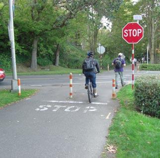
26 22 UNIVERSITY OF WASHINGTON BURKE-GILMAN TRAIL CORRIDOR STUDY PART III: CURRENT CONDITIONS Rainier Vista/Montlake Triangle The Trail intersects gravel pathways on the west and east sides of the Rainier Vista corridor. The Trail narrows where the it crosses the Rainier Vista access road using one of the old railroad bridges. Bicycle users of the Trail wishing to turn here are forced by the tight angles to slow down and make wide turns onto the gravel paths. Further complicating this movement is intersecting bicycle and pedestrian traffic connecting other bicycle routes from Montlake and Lake Washington and commuters from bus stops along SR 520. Hec Edmundson Bridge The intersection of the Trail with the pedestrian route to Hec Edmundson Pavilion will remain one of the most heavily used Trail crossings on campus. At present, steps lead from the bridge up to the main campus, connecting the Intramural Activities Building, Hec Edmundson Pavilion and Husky Stadium to the main campus. These steps end within one-foot of the Trail s edge in an area where sight lines are limited by vegetation. As previously discussed, bicyclists use this bridge extensively in order to access SR-520 and the Lake Washington Loop in order to avoid crossing Montlake Boulevard NE at grade. This creates conflict with pedestrians crossing the Trail as well as with other Trail users since these bicyclists must turn off the Trail, negotiate a steep descent of the bridge and make a tight, very slow speed 180 degree turn onto a ramp on the south side of the bridge. Trail traffic is governed by yield signs at this intersection. This intersection needs to be reconfigured to address the existing and continued congestion and conflicts as previously stated. A grade-separated option would be part of this analysis. Wahkiakum and Whatcom Lane Bridges North of the Hec Edmundson Bridge, the Wahkiakum and Whatcom Lane Bridges connect commuter parking lots north of the UW athletic facilities with the main campus. While sight lines are better at these intersections than those at the Hec Edmundson Bridge, there is an unmet need for better bicycle access up the stairs currently bicyclists must push their bikes up a worn footpath adjacent to the stairs. Trail traffic is governed by yield signs at this intersection. Figure 16. Looking west at the intersection of the Trail and Rainier Vista corridor Figure 17. Hec Edmundson Bridge (east end) Pend Oreille Road The Trail crossing at Pend Oreille Road is controlled by stop signs facing Trail traffic and is marked with a regular crosswalk. Observed bicyclist compliance with the stop signs is relatively low, as street traffic tends to be metered by the signals at 25th Avenue NE near the intersection. Pend Oreille Road has a slight grade, creating some sight line issues for both motorists and trail users. Figure 18. The stairs at Wahkiakum Lane Bridge Figure 19. Pend Oreille Road JULy, 2011 UNIVERSITY OF WASHINGTON SvR DESIGN COMPANY
27 UNIVERSITY OF WASHINGTON BURKE-GILMAN TRAIL CORRIDOR STUDY PART III: CURRENT CONDITIONS 23 Trail Counts A video count of pedestrian and bicycle volumes was taken on a sunny day, on October 12, 2010, at thirteen locations between 7:00AM and 6:00PM (see Figure 20) and analyzed by Fehr & Peers. In addition to trail volumes, where applicable, counts were obtained for bicycles and pedestrians crossing the trail at grade or using ramps or stairs to access the trail. The overall findings from the traffic count are as follows: The AM peak hour for combined pedestrian and bicycle traffic is between 7:45 8:45 AM; the PM peak is between 5:00 6:00 PM. Bicycle volumes show clear peaks in the AM and PM period, while pedestrian volumes are more evenly distributed, with small peaks from 12:00 1:00 PM and 5:00 6:00 PM. AM bicycle volumes are generally highest heading into and through campus from the north, and peak near the access point for the Montlake Bridge. Volumes are also high approaching from the west. They significantly decrease heading north from the Montlake Bridge. PM bicycle volumes show the opposite trend, with the highest volumes heading both north and west away from campus. Pedestrian volumes on the trail fluctuate between count locations, signifying a large number of short trips made using the trail. Overall, the highest pedestrian volumes are seen in the areas near the trail intersection with 15th Avenue NE, and at the Hec Ed and Wahkiakum Lane Bridges. Based on volumes of crossing traffic, the locations with the highest amount of potential bike and pedestrian conflicts are the Hitchcock Bridge, Hec Ed Bridge, and Wahkiakum Lane Bridge. NE 40th St NE 42nd St 185 (167) 107 (241) 60 (67) 29 (107) Lincoln Way NE Campus Pkwy NE 45th St!!!!!!!!!!!!!!!!!!!!!!!!!!!!!!!!!!!!!!!!!!!!!!!!!!!!!!!!!!!!!!!!!!!!!!!!!!!!!!!!!!!!!!!!!!!!!!!!!!!!!!!!!!!!!!!!!!!!!!!!!!!!!!!!!!!!!!!!!!!!!!!!!!!!!!!!!!!!!!!!!!!!!!!!!!!!!!!!!!!!!!!!!!!!!!!!!!!!!!!!!!!!!!!!!!!!!!!!!!!!!!!!!!!!!!!!!!!!!!!!!!!!!!!!!!!!!!!!!!!!!!!!!!!!!!!!!!!!! Brooklyn & Pacific West Eastlake Ave NE West of University Bridge Cowlitz Rd 162 (175) 111 (243) 106 (74) 30 (160) Burke Gilman Trail Portage Bay NE Pacific St 15th & Pacific West 203 (233) 139 (246) 137 (46) 38 (203) University Way NE 15th Ave NE Brooklyn & Pacific East Hitchcock Overpass 175 (251) 161 (208) 137 (117) 61 (126) 172 (229) 126 (272) 111 (74) 36 (166) 15th & Pacific East NE Pacific St J H Medical Center University of Washington 183 (242) 146 (255) 141 (89) 34 (226) T-Wing Overpass 103 (309) 197 (140) 30 (165) 58 (95) Rainier Vista West 237 (142) 71 (332) 109 (122) 49 (176) Pend Oreille North 278 (93) 27 (342) 74 (43) 18 (135) Pend Oreille South 278 (100) 30 (338) 71 (60) 13 (76) Wahkiakum Lane Overpass 262 (98) 33 (327) 44 (55) 23 (104) NE Paci fic Pl Mason Rd Pend Oreille Rd Montlake Blvd NE Burke Gilman Trail Rainier Vista East 25th Ave NE Hec Ed Overpass 277 (118) 75 (353) 120 (129) 58 (163) 250 (102) 51 (370) 100 (64) 33 (205) Montlake Bridge LEGEND Count Location Bicycle Pedestrian AM (PM) Count Volume Direction!!!!!!! Burke Gilman Trail N NOT TO SCALE Figure 21 outlines the average overall bicycle and pedestrian trail volumes at each hour throughout the day, while Table 2 shows volumes by location for the PM peak period. 0 Bike Ped Bike Ped Bike Ped Bike Ped Bike Ped Bike Ped Bike Ped 2010 West of University Bridge 15th Avenue Hitchcock Bridge Rainier Vista Corridor Hec Ed Wahkiakum Pend Oreille Figure 20. Trail count location and volumes with graph of counts, 2010 (PM peak hour). Top graphic lists through volumes (not crossing/turning) at peak hour. Bar chart reflects same numbers but also includes crossing/turning volumes at each respective point. UNIVERSITY OF WASHINGTON SvR DESIGN COMPANY JULy, 2011


28 24 UNIVERSITY OF WASHINGTON BURKE-GILMAN TRAIL CORRIDOR STUDY PART III: CURRENT CONDITIONS Bicycle Volumes There are clear AM and PM peaks in bicycle volume in the study area (see Figure 21 below). These trends are likely due to the high use of bikes commuting in the AM and PM periods. Between 10:00 AM and 2:00 PM the bicycle volume is flat at around 105 cyclists per hour, or less than half the peak volume. The highest volume of cyclists on the trail occurs in the AM peak hour entering the study area from the north, heading south. Based on count volumes between survey sites, it appears that these cyclists are heading to the UW Medical Center and the turnoff for the Montlake Bridge, rather than turning into campus During the PM peak hour, this trend is generally reversed, with a high volume of cyclists leaving the study area heading north. Pedestrian Volumes As seen in Figure 21, pedestrian volumes were generally flat during the survey, with the exception of higher volumes in the PM peak hour. Trail volumes varied from one observation point to the next (see Table 1), indicating that pedestrians primarily make use of the trail for short trips in and around campus, rather than using the trail as a through path to locations beyond campus. The highest overall trail pedestrian volumes were recorded around 15th Avenue and at the Hec Edmundson Bridge. The 15th Avenue area provides access to destinations near the south campus. The Hec Edmundson Bridge is a key pedestrian link to University sports facilities and large parking areas east of Montlake Boulevard. Due to a career fair on campus, pedestrian volumes at the Hec Edmundson Bridge were higher than they are likely to be under normal conditions. It is recommended that counts be conducted at regular intervals using this Study s methodology in order to more accurately determine normal volumes of pedestrians crossing at this location. Comparison to Previous Counts Between October 12th and 14th, 1999, peak hour pedestrian and bicyclist counts were made at eight locations on the Trail for the UW Campus Master Plan. On September 30, 2008, Sound Transit counted bicycle and pedestrian volumes on the Trail at the Rainier Vista Trestle, as cited in the report Pedestrian Report: University of Washington Station Pedestrian and Bicycle Evaluation by Grijalva Engineering, December 2008, prepared for Sound Transit. The results of both traffic JULy, 2011 counts were reported in the UW s 2010 technical paper, Proposed Bike Path Facilities on UW Campus Associated with Light Rail at Montlake and SR 520 Regional Bike Path. Table 1 compares these prior observations for the PM peak period with the findings from this study s October 2010 count. For the comparison, the bidirectional 2010 trail volume counts were merged (e.g. the two directions were added together) into a single number for bicyclists and a single number for pedestrians for each observation point, to be consistent with data from the previous studies. Bicycle volumes from the 2010 survey are higher at all locations than in previous studies. Average peak PM bicycle volume increased by 137% from the 1999 to the 2010 counts, with increases of almost 200% at the outer survey locations West of University Bridge and North of Pend Oreille. The higher volumes at the peripheral survey sites suggest an increased use of the Trail for commuting to and through campus. The University reported an increase of 10,000 students and employees during this time period. Pedestrian volumes show both decreases and increases from earlier studies, depending on location. These disparate results may reflect the impact of special events on campus pedestrian volumes, or may simply show that pedestrian volumes vary widely on a daily basis. During the 2010 survey, a career fair led to higher than normal volumes at the Hec Edmundson and Wahkiakum Lane Bridges. It is not known if any special circumstances or events affected the counts in 1999 or Average Hourly Bicycle and Pedestrian Volume Average Hourly Bicycle and Pedestrian Trail Volumes at Each Survey Site 7:00 AM 8:00 AM 9:00 AM 10:00 AM 11:00 AM 12:00 PM Survey Hour 1:00 PM 2:00 PM 3:00 PM 4:00 PM 5:00 PM Bicycles Pedestrians Figure 2. Average Bicycle and Pedestrian Volumes, Burke Gilman Trail, October 12, and Burke-Gilman Trail, October 12, Location Trail Approach Crossing Approach Potential Bicyclists Pedestrians Bicyclists Pedestrians Cross Conflict Area[a] Key Cycling Access/ Destination Location[b] West of University Bridge Brooklyn & Pacific West Brooklyn & Pacific East th & Pacific West th & Pacific East Hitchcock Overpass Bridge T Wing Overpass (on trail east of overpass) Rainier Vista West Rainier Vista East Hec Ed Overpass Bridge Wahkiakum Lane Overpass Bridge Pend Oreille South Pend Oreille North [a] Potential cross conflict areas are trail locations where more than 200 bicycle or pedestrian users crossed or accessed the trail during the PM Peak Hour. [b] Key access points are locations where the highest numbers of cyclists accessing or leaving the trail were observed. Table 1. October 12, 2010 PM Peak Hour Burke-Gilman Trail Crossing Volumes at Each Observed location Note: The Trail approach combines the users making a through movement and those turning right or left off of the Trail at each observation point. Likewise, the crossing approach includes users proceeding across both lanes of the Trail and those making a left or right turn onto the Trail at each observation point. UNIVERSITY OF WASHINGTON SvR DESIGN COMPANY

29 UNIVERSITY OF WASHINGTON BURKE-GILMAN TRAIL CORRIDOR STUDY PART III: CURRENT CONDITIONS 25 Future Year Forecasts Future Background Cycle Growth In order to understand the background growth in bicycle volumes due to land use changes and overall increases in local cycling rates, two methods were employed. First, using the City of Seattle Travel Demand Model, local land use changes were evaluated between now and This background growth, which is around 1.3%, was supplemented by data on bicycle volume growth rates on both the Trail and other areas of Seattle Households 2010 Employment 2030 Households 2030 Employment Annual HH Growth Table 2. Burke-Gilman Trail Study Area Household and Population Growth Annual Employment Growth Average Annual Growth % 1.6% 1.3% Source: City of Seattle Travel Demand Model, Fehr & Peers 2011 Land Use Evaluation To assist in understanding future growth in bicycle volume on the Trail in the study area, the expected land use changes surrounding the Trail in the study area were examined. While the University of Washington campus surrounds the immediate study area, bicycle volumes on the Trail are also affected by growth in the number of households and employment in the surrounding neighborhoods as the corridor is used for both recreation and commuting. In January 2011, a report that was prepared by the University of Washington s Department of Urban Design and Planning was published by the Puget Sound Regional Council (PSRC) 1. This report reviewed best practices and count methodology for bicycle planning, with a focus on the Puget Sound Region. As part of this they conducted a literature review of the main variables identified as affecting bicycling. To understand changes in land use in the study area corridor, this study evaluated the growth in the number of households and employment from 2010 to 2030 based on the City of Seattle Travel Demand Model within approximately one-half mile of the trail (see Table 2). The length of the study segment was approximately six miles. The western boundary was located 3 miles west of Rainier Vista at approximately 1st Avenue NW. The eastern boundary was located 3 miles north/ northeast of Rainier Vista at approximately NE 60th Street. Increased density and development is expected to increase the number of cyclists on the Trail in the study area Campus Master 2008 Sound Transit 2010 Fehr & Peers Survey Average Survey Survey* Annual Growth Rate Location Bicyclists Pedestrians Bicyclists Pedestrians Bicyclists Pedestrians Bicyclists Pedestrians W of University Bridge % 3.4% W of 15th % 2.5% Hitchcock Bridge % 2.2% T Wing Overpass Rainier Vista Trestle % 1.4% Hec Ed Bridge % 8.7% Wahkiakum Lane % 16.2% S of Pend Oreille % 4.7% N of Pend Oreille % 1.6% AVERAGE % 2.9% Table 3. Burke-Gilman Trail Bicycle and Pedestrian Volumes From 1999, 2008, and 2010 counts * 2008 Sound Transit survey data from December 2008 Grijalva Engineering report Figure 22. Data camera used in October 12, 2010 trail count 1. Bicycle Planning, Best Practices and Count Methodology. University of Washington Department of Urban Design & Planning - Transportation Planning Studio, Puget Sound Regional Council, April UNIVERSITY OF WASHINGTON SvR DESIGN COMPANY JULy, 2011
30 26 UNIVERSITY OF WASHINGTON BURKE-GILMAN TRAIL CORRIDOR STUDY PART III: CURRENT CONDITIONS For the purpose of this study, the Transportation Analysis Zones (TAZs) in the Seattle travel demand model that relate to this Trail corridor were selected. Using the selected TAZs, the number of households and employment in 2010 was compared with the number projected for While the background growth in cycling and walking as seen in Table 4 and Table 5 is limited, it is not expected that this rate of growth will stay low into the future. The benefits from having more diversity and density of land uses adjacent to the Trail will spur more cycling and walking as more origin and destination locations are sited adjacent to the Trail. This will further be increased by neighborhood design elements that make cycling and walking more attractive options for local residents and employees. Local Bicycle Volume Growth Rates A low growth estimate, consistent with background growth data, would likely understate the background growth in cycling. A report by the PSRC cited bicycle trail survey data from the Trail that volumes grew by 4.7% annually from 1985 to Additionally the portion of trips for commuting or shopping grew from 6% in 1985 to 38% in Study area counts on the Trail discussed in the previous section (obtained in 2010) show an overall annual increase of 7.9% based on counts obtained in 1999 for the Campus Master Plan. The same PSRC report cites bicycle counts in downtown Seattle showing an average annual growth rate of 5.8% from 1992 to More recent counts in downtown Seattle showed an annual increase of 7.2% from 2007 to Estimation of Background Bicycle Volume Growth Rate While study area growth in households and employment is expected to be relatively minor from 2010 to 2030, recent bicycle survey results show much higher regional growth in cycling rates. The central issue in forecasting future growth is whether or not recent increases in cycling rates are sustainable. Based on improvements identified in the Seattle Bicycle Master Plan, including extension of the Burke-Gilman Trail, increased cycling amenities are expected to encourage higher rates of 2. Regional Bicycle and Pedestrian Implementation Strategy, Puget Sound Regional Council, Bicycle Information, Seattle Department of Transportation. transportation/bikeinfo.htm Location Location 2010 PM Peak 2016 PM Peak Hour Pedestrians Hour Pedestrians 2030 PM Peak Hour Pedestrians W of Univ. Bridge W of 15th Hitchcock Bridge T Wing Overpass Rainier Vista Trestle Hec Ed Bridge 1,089 1,156 1,329 Wahkiakum Lane S of Pend Oreille N of Pend Oreille Source: Fehr & Peers, PM Peak Hour Cyclists 2016 PM Peak Hour Cyclists (High Estimate) 2030 PM Peak Hour Cyclists (High Estimate) W of Univ. Bridge ,309 W of 15th ,604 Hitchcock Bridge ,735 T Wing Overpass ,597 Rainier Vista Trestle ,629 Hec Ed Bridge ,738 Wahkiakum Lane ,376 S of Pend Oreille ,424 N of Pend Oreille ,418 Source: Fehr & Peers, 2011 Table 4. Future Burke-Gilman Trail Bicycle Volumes, PM Peak Hour Table 5. Future Burke-Gilman Trail Pedestrian Volumes, PM Peak Hour JULy, 2011 UNIVERSITY OF WASHINGTON SvR DESIGN COMPANY
31 UNIVERSITY OF WASHINGTON BURKE-GILMAN TRAIL CORRIDOR STUDY PART III: CURRENT CONDITIONS 27 cycling. Additionally as the cost of driving (parking, fuel, etc.) further increase, cycling may be an even more attractive option for the future. One issue that may hamper growth on the Trail in the study area is the effective capacity of the trail. Assuming mode separation (creating a separate pathway for pedestrians), the Trail in the study is expected to contain adequate capacity to accommodate future cycle growth. However, if such user separation is not created, growth in cycle volumes on the Trail may be limited by user-perceived trail congestion and its associated delay. Based on the above information, we anticipate an annual growth rate background growth in cycle volume to be 4.5% on the low end, and 6.0% on the high end. Recent counts show higher rates of increase in cycle volume, however it is our estimation that a slightly lower rate is more likely to occur over the next 6-20 years. Using this rate, the expected 2016 and 2030 PM Peak Hour Cycle volumes are presented in Table 4, using the higher estimate. As these estimates are based on October counts, these forecasted numbers estimate an average level of demand which is traditionally below the summer peak volumes. Future Background Growth Pedestrians Background growth in pedestrians is expected to be much more locally-driven than cycling, and to grow at a lower rate. The Seattle model predicts household and employment growth immediately surrounding the Trail in the study area as 0.8% between current rates and Related recent technical studies estimating background pedestrian volumes on the Trail for U-link construction assumed a background growth rate of 1%. 4,5 Based on the growth factor used elsewhere, coupled with the small forecasted change in local land use, this report assumes a 1% annual pedestrian growth rate to the 2010 counts. Growth Related to the University Link Transit Station In addition to the background growth in the PM peak hour cyclists and pedestrians on the Trail, the opening of the University LINK light Total Number of Patrons Patrons Traveling to UW LINK Station Patrons Traveling from UW LINK 2016 PM Peak Pedestrians Source: Grijalva Engineering, PM Peak Cyclists Table 6. UW LINK Station PM Peak Hour Patrons Location 2030 PM Peak Pedestrians 2030 PM Peak Cyclists 3, ,760 1,190 2, , , , PM Peak Pedestrian Trips to Station 2016 PM Peak Pedestrian Trips from Station 2016 PM Peak Bicycle Trips to Station 2016 PM Peak Bicycle Trips from Station W of Univ. Bridge W of 15th Hitchcock Bridge T Wing Overpass Rainier Vista Trestle Hec Ed Bridge Wahkiakum Lane S of Pend Oreille N of Pend Oreille Source: Fehr & Peers, 2011 Table LINK Bicycle and Pedestrian Trips (PM Peak Hour) 4. Pedestrian Report: University of Washington Station Pedestrian and Bicycle Evaluation, Grijalva Engineering, December Draft University of Washington Station Access Study, Jahns Engineering, May UNIVERSITY OF WASHINGTON SvR DESIGN COMPANY JULy, 2011
32 28 UNIVERSITY OF WASHINGTON BURKE-GILMAN TRAIL CORRIDOR STUDY PART III: CURRENT CONDITIONS Location 2030 PM Peak Pedestrian Trips to Station 2030 PM Peak Pedestrian Trips from Station 2030 PM Peak Bicycle Trips to Station 2030 PM Peak Bicycle Trips from Station rail station near the University of Washington stadium is expected to substantially increase bicycle and pedestrian volumes on certain segments of the Trail in the study area. Pedestrian and bicycle volumes for 2016 and 2030 were contained in the University of Washington Station Pedestrian and Bicycle Evaluation document, created in December 2008 by Grijalva Engineering. This document assumed that 80% of station patrons in the PM peak hour would be on foot and 20% would be on bicycle. The trip distributions were subsequently updated by Heffron Transportation in a December 2010 EIS Addendum that reflected an updated pedestrian connection project. For the purpose of this study, the 80%/20% split was used; however, this split will depend largely on facility and operating characteristics supporting bicycle access to LINK Light Rail. The projections assume that in 2016 the UW LINK Station is the northern system terminus and that in 2030 the Northgate LINK Station is the northern terminus. In the 2016 PM peak hour, 66% of overall patrons are expected to be travelling to the station with 34% travelling from the station. In 2030 during the PM peak hour, 72% of patrons are expected to be travelling to the station with 28% travelling from the station. Table 6 presents the total number of forecasted PM Peak patrons at the UW LINK station. Pedestrian Distribution The distribution of pedestrian trips in the area was revised from the original analysis and the update is contained within the December 2010 EIS Addendum. 2% of total station patrons are expected to use the Trail north of the Rainier Vista area. Additionally, 11% of station patrons are expected to use the Trail west of Rainier Vista at the T-Wing Overpass with 8% continuing on to the Hitchcock Overpass before leaving the trail. Bicycle Distribution The Heffron Transportation report did not directly address bicycle distribution; however it is assumed for the purpose of this study that their revisions around Rainier Vista for pedestrian flows will match those for bicycle volumes. West of Hitchcock Overpass it is assumed that 1% of station patrons will continue on the Trail out of the study area. Results Based on the above results, the main impact to the Trail during the PM peak hour is expected near the Hitchcock Bridge and T-Wing Overpass with the greatest impact being from the additional pedestrian volume. As discussed in the Shared-Use Path Level of Service section, trail W of Univ. Bridge W of 15th Hitchcock Bridge T Wing Overpass Rainier Vista Trestle Hec Ed Bridge Wahkiakum Lane S of Pend Oreille N of Pend Oreille Source: Fehr & Peers, 2011 Table LINK Bicycle and Pedestrian Trips (PM Peak Hour) 2016 Background Volume (High Estimate) 2016 Transit Station Volume 2016 Total Projected Volume Location Bicyclists Pedestrians Bicyclists Pedestrians Bicyclists Pedestrians W of University Bridge W of 15th Hitchcock Bridge T Wing Overpass Rainier Vista Trestle Hec Ed Bridge 769 1, ,232 Wahkiakum Lane S of Pend Oreille N of Pend Oreille Table 9. Future Burke-Gilman Trail Bicycle and Pedestrian Volumes for 2016 (PM Peak Hour) 2030 Background Volume (High Estimate) 2030 Transit Station Volume 2030 Total Projected Volume Location Bicyclists Pedestrians Bicyclists Pedestrians Bicyclists Pedestrians W of University Bridge 1, , W of 15th 1, , Hitchcock Bridge 1, ,830 1,045 T Wing Overpass 1, , Rainier Vista Trestle 1, , Hec Ed Bridge 1,738 1, ,762 1,424 Wahkiakum Lane 1, ,400 1,021 S of Pend Oreille 1, , N of Pend Oreille 1, , Table 10. Future Burke-Gilman Trail Bicycle and Pedestrian Volumes for 2030 (PM Peak Hour) JULy, 2011 UNIVERSITY OF WASHINGTON SvR DESIGN COMPANY
33 UNIVERSITY OF WASHINGTON BURKE-GILMAN TRAIL CORRIDOR STUDY PART III: CURRENT CONDITIONS 29 LOS is highly influenced by the number of pedestrians on the trail, as these users slow cyclist and necessitate more passing movements by cyclists. Based on future background growth estimation, the addition of the UW LINK light rail station is expected to have potential impacts at the following locations: The UW LINK station will more than double the number of pedestrians on the Trail at the T-Wing Overpass. The background pedestrian volume is expected to be 438 pedestrians, and the light rail station will add 524 pedestrians during the PM peak. At the Hitchcock Bridge, the LINK station will add 381 pedestrians by 2030, or an increase of 57% over 2030 baseline forecasts. On the north end of the study area, near Pend Oreille, the UW LINK light rail station will increase the volume of pedestrians by approximately 36% in Potential Conflict Points Trail segments and intersections with a high volume of pedestrians and bicycles are the locations most likely to be conflict points. There are numerous locations where bicyclists and pedestrians cross the Trail at grade. Conflict can be both physical conflict users running into one another or, more commonly, it can be the perception or threat of conflict. For pedestrians, the presence of faster moving traffic alone represents conflict, while to the bicyclist, it can be the potential for pedestrians unanticipated movements. Runners next to walkers, dogs on long leashes all represent either a real or perceived conflict. The volume of users on the Trail affects the perception of conflict and the ability to avoid it by reducing the room available to take action (turn, stop, slow) when a potential conflict presents itself.!!!!!!!!!!!!!!!!!!!!!!!!!!!!!!!!!!!!!!!!!!!!!!!!!!!!!!!!!!!!!!!!!!!!!!!!!!!!!!!!!!!!!!!!!!!!!!!!!!!!!!!!!!!!!!!!!!!!!!!!!!!!!!!!!!!!!!!!!!!!!!!!!!!!!!!!!!!!!!!!!!!!!!!!!!!!!!!!!!!!!!!!!!!!!!!!!!!!!!!!!!!!!!!!!!!!!!!!!!!!!!!!!!!!!!!!!!!!!!!!!!!!!!!!!!!!!!!!!!!!!!!!!!!!!!!! NE 40th St Brooklyn & Pacific West Eastlake Ave NE NE 42nd St West of University Bridge Lincoln Way Cowlitz Rd Burke Gilman Trail Portage Bay NE Pacific St 15th & Pacific West University Way NE 15th Ave NE NE Campus Pkwy Brooklyn & Pacific East Hitchcock Bridge NE 45th St th & Pacific East NE Pacific St J H Medical Center University of Washington ` 243 T-Wing Overpass Rainier Vista West Pend Oreille North Pend Oreille South Wahkiakum Lane Bridge l NE Pacific P Mason Rd Pend Oreille Rd Montlake Blvd NE Burke Gilman Trail 25th Ave NE Hec Ed Bridge Rainier Vista East Montlake Bridge LEGEND PM!!!!!! Count Location Bicycle Pedestrian Count Volume Direction Burke Gilman Trail N NOT TO SCALE Speed is also a factor. For pedestrians facing a bicyclist approaching or overtaking them, the faster the rider, the less time the pedestrians has to react. This situation is exacerbated if the bicyclist is moving at a speed consistent with or slower than other riders, but faster than the pedestrian, so that the pedestrian must take into account multiple potential conflicts when deciding upon evasive action. For bicyclists, the bicyclist s own speed is an additional factor influencing the bicyclist s ability to perceive and avoid conflict. The faster the speed, the less time is available to detect an obstacle, decide how to respond (change direction, apply brakes) and execute the maneuver Bike Ped West of University Bridge Bike Ped 15th Avenue Bike Ped Hitchcock Bridge Figure 23. Trail count location and volumes with graph of projected traffic counts, 2016 (PM peak hour). Top graphic lists projected through volumes (not crossing/turning) at peak hour, including both background growth and LINK generated traffic. Bar chart reflects same numbers but also includes crossing/turning volumes at each respective point. Bike Ped Bike Ped Bike Ped Bike Ped Rainier Vista Corridor Hec Ed Wahkiakum Pend Oreille UNIVERSITY OF WASHINGTON SvR DESIGN COMPANY JULy, 2011
34 30 UNIVERSITY OF WASHINGTON BURKE-GILMAN TRAIL CORRIDOR STUDY PART III: CURRENT CONDITIONS The intersections with poor sight lines and limited maneuvering space reduce this margin of error even further. As identified in Table 3, the locations with the highest pedestrian crossing volumes were at the Hec Edmundson and Wahkiakum Lane Bridges. Additionally a large number of pedestrians were observed crossing at the Hitchcock Bridge near UW south campus. As a result, management of potential and existing areas of conflict is a point of emphasis in Part V: Trail Design. The strategy is to provide both predictability in user movement and to improve potential conflict areas through a combination of a more formal traffic management system, separation of uses in high conflict areas, and design of intersections to passively control speed and improve user safety.!!!!!!!!!!!!!!!!!!!!!!!!!!!!!!!!!!!!!!!!!!!!!!!!!!!!!!!!!!!!!!!!!!!!!!!!!!!!!!!!!!!!!!!!!!!!!!!!!!!!!!!!!!!!!!!!!!!!!!!!!!!!!!!!!!!!!!!!!!!!!!!!!!!!!!!!!!!!!!!!!!!!!!!!!!!!!!!!!!!!!!!!!!!!!!!!!!!!!!!!!!!!!!!!!!!!!!!!!!!!!!!!!!!!!!!!!!!!!!!!!!!!!!!!!!!!!!!!!!!!!!!!!!!!!!!! NE 40th St Brooklyn & Pacific West Eastlake Ave NE NE 42nd St West of University Bridge Lincoln Way Cowlitz Rd Burke Gilman Trail Portage Bay NE Pacific St 15th & Pacific West University Way NE 15th Ave NE NE Campus Pkwy Brooklyn & Pacific East Hitchcock Bridge NE 45th St th & Pacific East NE Pacific St J H Medical Center University of Washington T-Wing Overpass 1, Rainier Vista West 455 1, Pend Oreille North 315 1, Pend Oreille South Wahkiakum Lane Bridge 338 1, , l NE Pacific P Mason Rd Pend Oreille Rd Montlake Blvd NE Burke Gilman Trail 25th Ave NE Hec Ed Bridge Rainier Vista East 378 1, Montlake Bridge 344 1, LEGEND PM!!!!!! Count Location Bicycle Pedestrian Count Volume Direction Burke Gilman Trail N NOT TO SCALE Bike Ped Bike Ped Bike Ped Bike Ped Bike Ped Bike Ped Bike Ped West of University Bridge 15th Avenue Hitchcock Bridge Rainier Vista Corridor Hec Ed Wahkiakum Pend Orielle Figure 24. Trail count location and volumes with graph of projected traffic counts, 2030 (PM peak hour). Top graphic lists projected through volumes (not crossing/turning) at peak hour, including both background growth and LINK generated traffic. Bar chart reflects same numbers but also includes crossing/turning volumes at each respective point. JULy, 2011 UNIVERSITY OF WASHINGTON SvR DESIGN COMPANY
35 part iv level of service evaluation
36
37 UNIVERSITY OF WASHINGTON BURKE-GILMAN TRAIL CORRIDOR STUDY PART IV: LEVEL OF SERVICE EVALUATION 33 Level of service EVALUATION Based on counts taken October 12, 2010, the study team calculated trail level of service (LOS) for two trail segments on the Burke-Gilman Trail using the Federal Highways Administration s Shared-Use Path Level of Service Calculator (SUPLOS). This LOS evaluation method analyzes segments, but not intersections. The segments received poor and failing grades by this method when analyzed as shared trails; however, these segments received excellent grades when analyzed as bicycle only trails. This suggests that a key potential service improvement for the trail is to separate the trail by user modes. LOS Analysis In 2006, the Federal Highway Administration, recognizing the increase and popularity in off-street shared use paths, created the SUPLOS calculator. This tool allows for a quantitative evaluation of current trail performance, as well as potential improvements. The tool also provides guidance on the number of additional users a trail can accommodate before trail conditions degrade. Prior to the creation of this tool, there was no consistent method for evaluating shared trail performance. The SUPLOS tool was developed from the perspective of cyclists. It is designed principally to evaluate bicycle mobility and to minimize conflicts and evasive maneuvers so that cyclists can maintain a constant speed. However, the tool s findings and recommended improvements will likely improve the trail condition for all users. The tool evaluates performance along segments of 1/4 mile or longer, but does not evaluate intersections. Thus, it does not factor in travel time or intersection-related delay, such as signals or stop signs at grade crossings. Additionally, the tool is not calibrated for trails wider than 20 feet due to a lack of trails wider than 20 feet available for testing; however, the model will provide a result for widths greater than 20 feet. A final note about the tool s performance related to centerlines. According to user surveys and observations, centerlines cause cyclists to feel constrained, so the addition of a centerline triggers the need for greater width to provide the same LOS. The SUPLOS tool s creators found that the primary factors influencing cyclists perceived LOS are: Path width Number of active passes (encountering other trail users travelling in the same direction and overtaking them) Number of meetings with users travelling in the opposite direction Presence of a striped centerline Further, the results showed that cyclists LOS was most affected by sharing a trail with slower users, with pedestrians having the most negative impact. Levels of Service The SUPLOS model uses six level of service categories with the letters A to F indicating best to worst. In general, grades A-C are considered acceptable levels of service. A: Excellent - Trail has optimum conditions for individual bicyclists and retains ample space to absorb more users of all modes, while providing a high-quality user experience. Some newly built trails will provide grade-a service until they have been discovered or until their ridership builds up to projected levels. B: Good - Trail has good bicycling conditions, and retains significant room to absorb more users, while maintaining an ability to provide a high-quality user experience. C: Fair - Trail has at least minimum width to meet current demand and to provide basic service to bicyclists. A modest level of additional capacity is available for bicyclists and skaters; however more pedestrians, runners, or other slow-moving users will begin to diminish LOS for bicyclists. D: Poor - Trail is nearing its functional capacity given its width, volume, and mode split. Peak period travel speeds are likely to be reduced by levels of crowding. The addition of more users of any mode will result in significant service degradation. Some bicyclists and skaters are likely to adjust their experience expectations or to avoid peak-period use. F: Failing - Trail significantly diminishes the experience for at least one, and most likely for all user groups. It does not effectively serve most bicyclists; significant user conflicts should be expected. SUPLOS Results As discussed above, using the SUPLOS model for calculating level of trail service for both bicycle and pedestrian use is difficult to correlate to actual performance. For the purpose of this study we recommend a minimum pedestrian LOS of C and a minimum LOS of B for bicycles. The two different categories are based on the anticipated steady growth of pedestrians through this area at 1% and a larger growth rate, Segment Time Period Overall LOS Score Overall LOS Grade LOS Score without Pedestrians LOS Grade without Pedestrians 15th Avenue to AM 1.89 F 4.17 A Rainier Vista PM 1.8 F 4.18 A Hec Edmundson Overpass to Wahkiakum Lane Overpass AM 2.84 D 4.37 A PM 1.77 F 4.41 A Table 3. Burke Gilman Trail Level of Service Based on October 12, 2010 Cou Table 11. Burke-Gilman Trail Level of Service Based on October 12, 2010 Counts. UNIVERSITY OF WASHINGTON SvR DESIGN COMPANY JULy, 2011
38 34 UNIVERSITY OF WASHINGTON BURKE-GILMAN TRAIL CORRIDOR STUDY PART IV: LEVEL OF SERVICE EVALUATION relative to that of pedestrians, in number of bicycle users, influenced by numerous factors including new connections created by nearby projects, such as SR 520. SUPLOS was calculated for two segments on the Trail in the study area. Due to the nature of the study area, long segments with no crossing points were not exclusively available for analysis. However, two segments were chosen with end points at busy intersections, and conditions on the trail in between these points were analyzed. The first segment was the 1/3 mile long segment between 15th Avenue and Rainier Vista/Montlake Triangle. This area has multiple access and crossing points. The second was the ¼ mile long segment between the Wahkiakum and Hec Edmundson Bridges. There are a limited number of trail access points in this corridor. The segment SUPLOS showed a poor or failing grade for the analyzed trail segments as shared trails. As shown in Table 11, the segment between 15th Avenue NE and Rainier Vista/Montlake Triangle received an F for both AM and PM peak periods. The peak period is the hour surrounding the AM or PM fifteen minute period with the highest traffic volumes. The segment between the Hec Edmundson Bridge and the Wahkiakum Lane Bridge, received a D for the AM period and an F for the PM period. The SUPLOS was then recalculated using bicycle volumes only. As a bicycle only trail, both segments analyzed received an A for all time periods. These results suggest that the Trail as currently configured is sufficient to serve bicyclists but is not configured to adequately serve both bicyclists and pedestrians. The SUPLOS model is sensitive to trail width, allowing for sensitivity testing of various width scenarios. However, due to future volumes of trail users related to both background growth and LINK users, there is a point where either Trail traffic is separated, or the Trail must be expanded to impractical widths to mitigate user conflict and maintain the Trail s transportation function. Shared Use Path LOS By Segment The Shared Use Path LOS (SUPLOS) Calculation tool is designed and calibrated for analyzing trail segments of one-quarter mile in length or longer with no major access points. However, to better understand operating conditions along various segments of the Trail, it is used in this section for an approximate measure of user-perceived LOS and delay for segment comparison purposes. Segment Wahkiakum Lane N (PM) Hec Ed - Rainier Vista West (PM) T-Wing Overpass Area (PM) Width Assumed (ft) Overall LOS Score Overall LOS Grade Bike-only LOS Score Bike-only LOS Grade E 4.19 A F 3.93 B F 3.98 B Hitchcock Bridge West (PM) E 4.00 B Source: Fehr & Peers, 2011 Table PM Peak Hour LOS, Burke-Gilman Trail, Background Volume Only Segment Wahkiakum Lane N (PM) Hec Ed - Rainier Vista West (PM) T-Wing Overpass Area (PM) Hitchcock Bridge West (PM) Width Assumed (ft) Overall LOS Score Overall LOS Grade Bike-only LOS Score Bike-only LOS Grade E 4.19 A F 3.93 B F 3.92 B F 3.99 B Source: Fehr & Peers, 2011 Table PM Peak Hour LOS, Burke-Gilman Trail, Background Volume Plus Montlake LINK Patrons Segment Wahkiakum Lane N (PM) Hec Ed - Rainier Vista West (PM) T-Wing Overpass Area (PM) Hitchcock Bridge West (PM) Width Assumed (ft) Overall LOS Score Overall LOS Grade Bike-only LOS Score Bike-only LOS Grade F 3.80 B F 3.44 C F 3.65 B F 3.56 B Source: Fehr & Peers, 2011 Table PM Peak Hour LOS, Burke-Gilman Trail, Background Volume Only JULy, 2011 UNIVERSITY OF WASHINGTON SvR DESIGN COMPANY
39 UNIVERSITY OF WASHINGTON BURKE-GILMAN TRAIL CORRIDOR STUDY PART IV: LEVEL OF SERVICE EVALUATION 35 The results in this section compare delay and LOS in 2016 and 2030 for four segments of the Trail, with and without the Montlake LINK Station (see Tables 12-15). Such analysis allows for a comparison of delay based on expected levels of background growth and the potential impact of additional bicycle and pedestrian trips to and from the LINK station. It uses ridership and patron distribution developed by Sound Transit, and updated by Heffron Transportation. The results of this analysis indicate that in all scenarios, the combined bicycle and pedestrian volumes on the Trail lead to LOS E or F in the four study corridors. In all scenarios, there is a large benefit seen from separating bicycle and pedestrian trail users. However, in 2030 conditions with the Montlake Link Station, two segments still experience LOS C during the PM peak hour. A further analysis of these segments indicates that expanding the bicycle-only trail width to 15 feet will result in LOS B operations. The largest increase in delay seen as a result of the additional LINK patrons is at the T-Wing Overpass in both 2016 and Shared Use LOS Conclusions Looking at the various LOS evaluations of existing Trail width (Tables 12-15), it is apparent that separation of bike/wheeled and pedestrian uses will accommodate planned and forecast growth in trail use through Without separation, both pedestrian and bicycle level of service fail at those areas (15th Avenue NE to Hec Ed Bridge) with the highest volumes of users. It is difficult to compare pedestrian and bicycle level of service directly, as the methodologies involved in both differ (as do the peak daily travel times), but both models reflect the impact of increased demands on the trail from new transit service, growth on the UW campus, and general forecast growth in bicycling activity throughout the City of Seattle. The combination of pedestrians and bicyclists at even the current volumes at higher volume segments cause the LOS on the current 12-foot wide trail to fail. Separating the pedestrians and bicyclists will improve LOS. While the existing 14-foot wide Trail would provide a good to excellent for bicyclists without pedestrian traffic, results from the LOS analysis show that a separate 10-foot wide parallel trail constructed to accommodate pedestrians, would provide an adequate Level of Service through 2030 for both pedestrians and bicyclists. Development of a 14-foot separated bicycle track will allow for Segment Width Assumed (ft) Overall LOS Score Overall LOS Grade Bike-only LOS Score Bike-only LOS Grade Wahkiakum Lane N (PM) F 3.79 B Hec Ed - Rainier Vista West (PM) F 3.29 C T-Wing Overpass Area (PM) F 3.32 C Hitchcock Bridge West (PM) F 3.55 B Source: Fehr & Peers, 2011 Table PM Peak Hour LOS, Burke-Gilman Trail, Background Volume Plus Montlake LINK Patrons Pedestrian Trail Width (ft) Pedestrianonly LOS Grade without Separation Pedestrian-only LOS Grade with Separation Bike Trail Width (ft) Bike-only LOS Grade without Separation Bike-only LOS Grade with Separation 6 F F F C F B 10 F F B F B A Source: Fehr & Peers, 2011 Table PM Peak Hour LOS, Burke-Gilman Trail, Background Volume Plus Montlake Link Patrons Pedestrian Trail Width (ft) Pedestrianonly LOS Grade without Separation Pedestrian-only LOS Grade with Separation Bike Trail Width (ft) Bike-only LOS Grade without Separation Bike-only LOS Grade with Separation 6 F F F D F C 10 F F C F B B Source: Fehr & Peers, 2011 Table PM Peak Hour LOS, Burke-Gilman Trail, Background Volume Plus Montlake Link Patrons UNIVERSITY OF WASHINGTON SvR DESIGN COMPANY JULy, 2011
40 36 UNIVERSITY OF WASHINGTON BURKE-GILMAN TRAIL CORRIDOR STUDY PART IV: LEVEL OF SERVICE EVALUATION continued anticipated growth in wheeled Trail use, while the separate pedestrian track will not only be able to accommodate the anticipated growth in pedestrian users but will also be able to manage the potential user conflicts arising from crossing to the University of Washington Link Station and rerouted ST Express and Metro Transit bus service that an increase trail width alone cannot accommodate. Pedestrian LOS Conclusions The 6-10-foot pedestrian width was analyzed using the Highway Capacity Manual formula for pedestrian level of service on uninterrupted walkway segments for the exclusive use of pedestrians. Projected pedestrian volumes for the 2030 PM peak hour were selected for analysis since all major development projects are expected to be completed by that date, including an extension of the University Link north to Northgate. Using the forecasted 2030 PM peak hour pedestrian volumes, widths are predicted to function at Level of Service A. However, if severe platooning (users travelling at a consistent speed in a clump) is factored into the equation, the LOS for a 10-foot wide trail in congested areas would be calculated as Level C. Special events on or near the Trail, such as football games and mass participation events, will also reduce LOS. Consequently, additional measures would need to be considered to meter or otherwise control the exceptional flows of pedestrians on event days. Application of SUPLOS Methodology to Analysis of Proposed Bicycle Facility Width 12 feet returns a value at the low end of LOS B with some sections functioning at C. Fourteen feet reflects a value of LOS B, while LOS A requires development of a bicycle facility at a somewhat unrealistic foot width. The application of the appropriate Level of Service Standard will occur in the formal design process of each specific segment. As the standard reflects peak hour conditions, it would be prudent to preserve sufficient right of way to accommodate the highest likely potential future user condition, even if the full width of the trail is not initially developed. Assuming eventual development of a path with LOS B bicycles and LOS C for pedestrians, a right of way width of 40 feet should be preserved to allow for future growth in user demand, allowing facility resilience and flexibility beyond Pedestrian LOS values are not as sensitive to localized changes in volumes the current methodology returns LOS E or F for widths less than 8 feet. As in the UW Study from August 2010, we recommend a pedestrian track width of 10 feet and bicycle track width of 14 feet in the highest volume areas of the Trail, specifically that between 15th Avenue NE and the Hec Ed Bridge. We recommend that Trail segments west of 15th Avenue NE and north of the Hec Ed Bridge have a minimum pedestrian track width of 8 feet and minimum bicycle track width of 12 feet. WIDTH OF 2-WAY CYCLE FACILITY LOS A B C D E F 14 TWO-WAY BIKE FACILITY 12 TWO-WAY BIKE FACILITY 10 TWO-WAY BIKE FACILITY LOS A B C D E F Using the SUPLOS model, the accompanying graph (see Figure 25) was developed to show how a separated bicycle facility would perform at different locations along the Trail corridor with different proposed widths. Utilizing modeled forecasts of bicycle traffic for peak hour in 2030, the graph shows how increased volumes of bicycle traffic would require additional width to mitigate the effects of additional user conflict. The results of the analysis correspond closely to the findings and recommendations of the University s study Proposed Bike Facilities on UW Campus Associated with Light Rail at Montlake and SR 520 Regional Bike Path (August 2010; see Part II, Page 13 inset box). Assuming a trail profile that separates pedestrian and bicycle traffic, LOS C is achieved with a 10 foot wide two way bicycle facility, while BROOKLYN 2 15TH 3 HITCH- COCK 4 T-WING 5 RV WEST LOCATION 6 RV EAST 7 HEC ED BRIDGE 8 WAHKIA- KUM LANE Figure Shared Use Path Level of Service Findings for Trail Locations on UW Campus (Bicycle Results by 2-Way Path Width) 9 PEND OREILLE JULy, 2011 UNIVERSITY OF WASHINGTON SvR DESIGN COMPANY
41 UNIVERSITY OF WASHINGTON BURKE-GILMAN TRAIL CORRIDOR STUDY PART IV: LEVEL OF SERVICE EVALUATION 37 Comparison To Other Trails - Width Trail widths in other areas Washington and around the country usually reflect the design guidelines that were used by the managing jurisdiction at the time the trail was developed. Many of the early trails in this region, including the Interurban Trail, Burke-Gilman Trail, and Sammamish River Trail were developed following AASHTO Guidelines for the Development of Bicycle Facilities. Over time, both AASHTO and local agencies have widened the recommended cross sections for new trails in response to the impacts of growth on older trails. While older trails were generally developed with a foot paved width, more recent projects have been built with widths of 14 feet and, in some cases, 16 feet. Note that these cross sections do not include the additional width of unpaved shoulders or separated pedestrian/ equestrian tracks. For example, over the years, the Sammamish River Trail has been expanded from 10 feet to 14 feet wide near the downtown Redmond core and parallel pedestrian paths have been developed on the other side of the river to passively separate uses. The relatively new SR- 520 Trail was built to a base 14-foot width, with expansion in areas of pronounced grade. As part of many improvements to existing trails, including the Sammamish River Trail, attempts are made to manage trail access points either by limiting the number of access points or by designing access points to accommodate the perceived conflict arising from turning movements, acceleration and braking, the tendency of all users to gather at particular rest locations, and so on. UNIVERSITY OF WASHINGTON SvR DESIGN COMPANY JULy, 2011
42 38 UNIVERSITY OF WASHINGTON BURKE-GILMAN TRAIL CORRIDOR STUDY PART IV: LEVEL OF SERVICE EVALUATION JULy, 2011 UNIVERSITY OF WASHINGTON SvR DESIGN COMPANY
43 part V trail design
44


 and trail bridge with separate areas for bicycles and pedestrians.")
45 UNIVERSITY OF WASHINGTON BURKE-GILMAN TRAIL CORRIDOR STUDY PART V: TRAIL DESIGN 41 Trail design As discussed in Part IV, it is recommended that the Burke-Gilman Trail be developed as a separated trail with a foot wide bicycle track and an 8-10-foot wide pedestrian track in order to achieve desired LOS performance. Part V explores various conceptual design options for the Trail s uninterrupted segments. The Trail s evolution represents an opportunity to enhance the UW identity and further the UW s commitment to LID. Figure 26. Brygge Broen (Wharf Bridge) split mode bicycle / pedestrian bridge in Copenhagen, Denmark. Figure 27. Low volume trail (above) and trail bridge with separate areas for bicycles and pedestrians. Figure 28. Low volume trail (above) and trail bridge with separate areas for bicycles and pedestrians. Part V also includes a suggested palette of design elements to integrate the Trail with the overall UW identity, improve safety and wayfinding and incorporate LID elements. Intersection design is addressed in Part VI. There are areas of the trail that under current traffic patterns can remain shared (between Hec Ed and Pend Oreille); however, with projected growth these sections should be separated by A Note About Trees Many segments of the Trail corridor through the UW Campus have existing trees of various sizes and significance that could be impacted by Trail improvements described in this document. As the next phase of design progresses, an arborist should conduct a tree evaluation and designation as described in the Campus Tree Care Plan. Based upon this assessment, the final alignment width and design should carefully consider and appropriately mitigate impacts to extraordinary, exemplary, or significant trees. Designers should also consider the merits of existing tree groves. Conceptual Approaches Street separation of bicycles and pedestrians within a multi-use trail has not been recently attempted in the Seattle area; and earlier attempts to separate with painted use zones have not proven particularly effective such as is seen at the Greenlake Trail in north Seattle. Here, the trail is divided into painted zones one for pedestrians that is two-way, and the other a one-way bike/wheels zone. The path is wide open to cross traffic, and compliance with the indicated zones is considered sporadic. Figures 26, 27, and 28 illustrate application of separated trail design principles in Copenhagen, Denmark. Rather than use paint to separate areas on the same paved surface, alternative means of creating separate tracks for wheeled uses and for pedestrians were considered. Two basic approaches were considered: UNIVERSITY OF WASHINGTON SvR DESIGN COMPANY JULy, 2011
46 42 UNIVERSITY OF WASHINGTON BURKE-GILMAN TRAIL CORRIDOR STUDY PART V: TRAIL DESIGN vertically separating the two tracks and laterally separating the two tracks. Earlier studies of the Trail have suggested adopting the vertical separation approach. Five different conceptual cross sections were explored. Per AASHTO design practice (and in locations where feasible), all sections include 2-foot wide soft shoulder on either side of the Trail. For bicycle tracks, a 2-foot shoulder is considered a normal clear zone for obstructions. It also serves as a pull-off area. On the pedestrian side of the Trail, a 2-foot gravel shoulder reduces perceived conflicts between runners and bicyclists by providing a more attractive surface to draw runners off the main pedestrian trail. Each conceptual section includes some type of separation between bicycle and pedestrian areas of the Trail. While this separation is shown as a curb or narrow band in these sections in order to minimize the overall Trail footprint, this separation could be wider in some areas and include a sloped median, as appropriate for conditions in specific areas of the Trail. 2 shoulder 8-10 pedestrian Section 1: Vertical separation of bicycles and pedestrians Preferred option for high volume and conflict areas 6 curb or slope separation cyclist 2 shoulder Section 1 vertically separates pedestrians on an adjacent track to the north and west of and 6-inches above the wheeled track. This option allows for improved pedestrian safety and more closely follows the predominate topography of the trail. One advantage to this approach is that it more easily allows for the development of traffic tables (raised areas) at key intersection and conflict areas. Wheeled traffic would travel up a 5-percent ramp into the intersection area, which would be further distinguished from the normal trail track with different paving material. Pedestrians would maintain the same grade on the path and in the intersection. The presence of a curb keeps bikes in their portion of the path to a greater extent than with a flat trail with a rumble divider. Pedestrians walking adjacent to the bike section have a greater confidence that conflict is minimized, thus improving the performance of the facility in both practical and LOS contexts. It is important that lighting on the Trail be improved on all sections with vertical separation, to mitigate potential night lighting tripping hazards. 2 shoulder cyclist 6 curb Section 2: Vertical separation with pedestrian facilities on south and east side of Trail Eliminated due to increased potential for user conflict at intersections 8-10 pedestrian 2 shoulder Section 2 also vertically separates uses, but places pedestrian uses on the south and east side of the bicycle track. While it has the same advantages as Section 1, Section 2 has a greater potential to create user conflicts at intersections, as pedestrians will be making turns from multiple locations, increasing the number of direct conflict points within the intersection and making corrective maneuvers on the part of bicyclists harder to anticipate and execute. JULy, 2011 UNIVERSITY OF WASHINGTON SvR DESIGN COMPANY
47 UNIVERSITY OF WASHINGTON BURKE-GILMAN TRAIL CORRIDOR STUDY PART V: TRAIL DESIGN 43 Section 3 includes two elevated pedestrian tracks that split users by travel direction. The disadvantage to this approach is that it limits the Trail s ability to handle the larger pedestrian volumes generated by special events. This section would also require pedestrians and bicyclists to look for conflicts from multiple directions. 6 curb 6 curb Section 4 keeps all users at the same grade, but laterally separate uses with a 1-foot granite paver strip, rails or other low vertical elements. The advantage to this approach is that while it may require more space, it may be less costly to develop. It also has more flexibility where there are a number of informal or low volume side access paths on both sides of the trail. This option also provides management flexibility for special events. It does not provide the same level of security for pedestrians, but can accommodate a more complex traffic pattern. 2 shoulder 5 pedestrian Section 3: Vertical separation with split pedestrian facilities Eliminated due to constrained ability to manage larger pedestrian volumes cyclist 5 pedestrian 2 shoulder Like Section 4, Section 5 keeps all users at the same grade but uses a rain garden to separate the pedestrian and bicycle tracks. While such a design feature can do much to mitigate the impacts of increased surface runoff (depending upon the paving material used), such an approach is more costly and requires more space. Section 5 may require more space than Section 4 and would likely be more costly. Section 1, basic vertical separation, and Section 4, basic lateral separation, were selected for further concept development due to the fact that they have the smallest footprint of the options explored. Because of its greater flexibility in integrating with different intersection design options, Section 1 was selected for use in higher volume areas where conflicts are more likely to occur. Section 4 was selected for use in areas with less available space and for locations which have lower traffic volume and less potential for user conflicts. Section 5 may also be appropriate in certain locations along the Trail where sufficient width exists, but it was not explored further at this time. 2 shoulder 8-10 pedestrian 1 divider cyclist Section 4: Lateral separation Preferred cross section for constrained space and locations with lower volume and less potential for user conflict 2 shoulder The two sections selected for further development rely on different types of separation to maintain an acceptable level of service. The vertical separation physically prevents most cyclists from encroaching onto the pedestrian track the choice of surface material can further encourage proper bicycle use by providing a smoother, more bicycle friendly asphalt surface on the cycle track while providing a rougher but very walkable pervious concrete surface on the pedestrian track. Additionally, signage can reinforce the operational regulations for these heavily utilized sections of the Trail. The ultimate selection of section type will occur in the formal design process for each Trail segment. 2 shoulder 8-10 pedestrian varies rain garden (3-4 MIN) Section 5: Lateral separation with LID drainage as median. Possible option in some segments along the Trail, but not explored further in this Study cyclist 2 shoulder UNIVERSITY OF WASHINGTON SvR DESIGN COMPANY JULy, 2011
48 44 UNIVERSITY OF WASHINGTON BURKE-GILMAN TRAIL CORRIDOR STUDY PART V: TRAIL DESIGN Spatial Implications of Trail Design Approaches The existing Trail is defined by a relatively small asphalt band and treed edges with sight lines to the adjacent roads. Expanding the Trail to improve service will impact both the Trail and the areas adjacent to it. At the level of this study, we conducted diagram-level testing of several sectional relationships between the trail and the surrounding landscape. This is meant to provide a menu of options for refinement in future design processes. Five different design approaches were explored for implementing the new trail design within the landscape. Approach 1 takes the straightforward approach of widening the Trail and steepening the adjacent slopes. In addition to there being few places along the Trail with sufficient space to accommodate this approach, Approach 1 has several disadvantages. The extensive regrading of adjacent slopes will result in the removal of more trees and adjacent vegetation than any other approach. The new, steeper slope will also provide the least sense of spatial enclosure, i.e., the sense that the Trail is its own unique environment that feels separated from the busy streets that flank it. This is because the steep slopes will maintain sight lines to the adjacent streets, particularly during the many years it will take for the revegetated slopes to leaf out. Since horizontal space is constrained in many places along the Trail, the remaining approaches employ retaining walls to manage Trail expansion. The approaches using retaining walls will require less regrading and will, consequently, have the ability to retain more existing trees and other vegetation. Using retaining walls, however, may be more expensive than steepening the slope in some locations. An additional concern with all approaches using retaining walls is the risk of graffiti and the resulting increase in maintenance costs. This concern should be considered in each location and addressed by revegetating in front of the wall and/or developing a maintenance plan. Approach 2 uses an outboard retaining wall between the Trail and the adjacent roadway. This approach has the advantage of screening roadways from view. The wall could potentially present a blank, unattractive face to the public along the road; however this could be overcome by revegetating the slope in front of the wall or using a surface treatment on the wall to provide visual interest. Approach 3 adds a mound to Approach 2 in order to provide more screening from the road and to provide a consistent feature to reinforce the sense of the Trail as a unique location. Adding the mound would increase costs, however. Typical Existing Condition Approach 1: Widen + Steepen Approach 2: Outboard Wall This typical existing cross section for the Trail shows some of the features that define it today: relatively small asphalt band treed edges sight lines to the adjacent roads Implications: revegetating slopes most trees likely cut down weak, inconsistent spatial enclosure* sight lines maintained to adjacent roads few places with enough space to accomplish this arrangement Implications: maintains some trees and vegetation biking and walking through the canopy stronger, inconsistent spatial enclosure* cost implications screens roadways from view a blank, unattractive wall would present a poor face to the public * Spatial enclosure refers to the overall visual effect of vegetation, walls and other landscape elements to create a distinct, separated space, defined by strong vertical edges and an overhead canopy. We ve evaluated both the strength of the enclosure and the consistency of treatment from side to side across the trail corridor. JULy, 2011 UNIVERSITY OF WASHINGTON SvR DESIGN COMPANY
49 UNIVERSITY OF WASHINGTON BURKE-GILMAN TRAIL CORRIDOR STUDY PART V: TRAIL DESIGN 45 Rather than employing an outboard wall, Approach 4 uses a wall placed inboard of the Trail. This approach would maintain the greatest amount of existing vegetation on the slope between the Trail and the road. The inboard wall could also include seating and lighting for the Trail. The disadvantage with this approach is that, as in Approach 1, Approach 4 will not provide a strong sense of spatial enclosure because it will maintain sight lines to the roadway. Approach 5 adds an outboard mound to Approach 4. Where space and existing vegetation allow for this approach, it provides many advantages. As in Approach 4, the inboard wall can be used for seating and lighting. The outboard mound provides visual interest and a consistent spatial enclosure that screens the trail from the road. Like Approach 3, Approach 5 would be more expensive due to the inclusion of both a retaining wall and a mound; however, the added contribution to the experience of the Trail as a unique feature of campus could make it worthwhile. Recommended Approaches for Trail Segments The following section describes a recommended section and spatial approaches for each trail segment. Pasadena Place NE to 15th Avenue Segment This segment entails development of a laterally separated trail from 15th Avenue NE to Pasadena Place NE. Along the Mercer Hall corridor, the large conifers on the south side of the trail and the allée of mature multi-stemmed trees along the north side should be preserved, if possible. Adding a retaining wall along the north side of the trail would provide greater width for the trail while minimizing impacts to the adjacent slope. The access road along the trail s north edge appears to be little used, and conflicts with the expansion of the trail. Narrowing or rerouting the roadway may be possible and would allow more options in expansion of the Trail. 15th Avenue to T-Wing Overpass Segment At Hitchcock Bridge, the development of the wider profile will require modification or replacement of the existing railroad trestle/bridge, while maintaining and improving pedestrian access to the bus stop on Pacific below. Approach 3: Outboard Wall + Mound Approach 4: Inboard Wall Approach 5: Inboard Wall + Outboard Mound Implications: maintain trees and vegetation outboard of the wall strong, consistent spatial enclosure* cost implications screens roadways from view inboard wall could be used for lighting and/or seating a blank, unattractive wall would present a poor face to the public Implications: maintains most outboard trees and vegetation inboard wall could be used for lighting and/or seating cost implications weak, inconsistent spatial enclosure* Implications: maintains some trees and vegetation strong, inconsistent spatial enclosure* cost implications screens roadways from view inboard wall could be used for lighting and/or seating * Spatial enclosure refers to the overall visual effect of vegetation, walls and other landscape elements to create a distinct, separated space, defined by strong vertical edges and an overhead canopy. We ve evaluated both the strength of the enclosure and the consistency of treatment from side to side across the trail corridor. UNIVERSITY OF WASHINGTON SvR DESIGN COMPANY JULy, 2011


50 46 UNIVERSITY OF WASHINGTON BURKE-GILMAN TRAIL CORRIDOR STUDY PART V: TRAIL DESIGN 6 curb T-Wing Overpass to Hec Ed Bridge Segment The development of a wider, separated trail in the area of Rainier Vista and the Montlake Triangle will involve the addition of retaining walls both along NE Pacific Street and along the Trail on the Montlake Boulevard NE side of the University of Washington campus. Northeast of Montlake Triangle, retaining wall development can occur on either side of the Trail, and can serve to assist in the development of better sight lines on the Trail s major pedestrian crossings. 2 shoulder 10 pedestrian 14 cyclist 2 shoulder As noted in Part III, to the northeast of the Rainier Vista area, the Trail s south or southeast slope contains several clusters of large trees and shrubs that should be preserved if possible. Due to the existing vegetation and steep slopes alongside the trail, this area should use the narrowest recommended section. In addition, separating the pedestrian and bicycle trails and/or using retaining walls along this segment could enable preservation of these trees and maximize the possible trail width. gravel Section 6: Grade-Separated Section pervious concrete regular concrete porous asphalt gravel Hec Ed Bridge to Pend Oreille Road Segment Retaining wall development could occur on either side of the Trail in this segment, allowing a wider section and improved sight lines especially at the Trail s major pedestrian crossings, including crossings at the Hec Edmundson, Hitchcock and Wahkiakum Bridges. Pend Oreille Road to NE 47th Street North of Pend Oreille Road, the Trail should transition to match the existing width, with selected traffic control devices incorporated into the area near the intersection. Trail Surface Currently, the Trail is paved with asphalt, the most common surface used for paving trails. Asphalt has the advantage of providing a smooth surface at reasonable cost; however, asphalt is subject to more frequent maintenance as the surface degrades and tree roots heave it up. Concrete is a longer lasting material, but has higher initial costs. Standard asphalt and concrete are both impermeable requiring management of surface runoff. Based on current City of Seattle code, reconstruction of the trail would require storm drainage mitigation. 2 shoulder 8-10 pedestrian 1 divider cyclist 2 shoulder In recent years, permeable versions of both asphalt and concrete have been developed that are highly suitable for trail applications. Permeable asphalt has a distinct advantage over traditional asphalt in gravel pervious concrete Section 7: Texture-Separated Section textured atgrade divider porous asphalt gravel JULy, 2011 UNIVERSITY OF WASHINGTON SvR DESIGN COMPANY

51 UNIVERSITY OF WASHINGTON BURKE-GILMAN TRAIL CORRIDOR STUDY PART V: TRAIL DESIGN 47 that it reduces puddling and winter freeze-over, both of which are spill hazards for cyclists. While permeable concrete surfaces are considered somewhat too rough for general cycling, they are appropriate for pedestrian paths. The difference in paving material can also serve to reinforce the Trail s separated pedestrian and bicycle tracks. Where the Trail s uses are laterally separated, a 1-foot wide strip paved with a material different in size and texture from both the pedestrian and the bicycle tracks is recommended, such as granite or pavers. Crushed limestone is commonly used for trail shoulders is recommended for the shoulders in this location as well. Wayfinding The 14-foot wide bicycle track would include a painted centerline to channel bicycle traffic. While centerlines divide and can thus constrain wheeled movement and LOS on a trail, LOS will not be affected if the Trail is wide enough to allow passing without forcing bicycles into the oncoming bicycle path of travel. The recommended 14-foot wide bicycle track for the Trail is wide enough to allow for a dashed centerline. Dashed centerlines reinforce the desired direction of travel while also permitting overtaking in the opposing lane if necessary, similar to two lane rural roads. It is also possible to use other pavement markings consistent with MUTCD practice to channelize turning movements, reinforce stop signs and other traffic control devices if so desired. Such markings are consistent with, but not required by current state and federal design guidelines for trails. Additional symbols and tactile warning strips at intersections are also used to reinforce traffic calming design elements. Since the Trail is both an intra-campus and a regional transportation facility, the Trail s wayfinding system should integrate with University, City and regional wayfinding systems. The UW campus portion of the Trail is currently covered by multiple wayfinding systems, a situation that is likely to continue in the future. These wayfinding systems include the UW campus wayfinding system, the City of Seattle s bicycle wayfinding system and regional trail signage defined by the Puget Sound Regional Council that is implemented at the municipal level. In addition, wayfinding signage associated with Sound Transit and King County Metro will be a part of the new University of Washington Link Station. There is a risk that applying so many wayfinding schemes to the Trail will be confusing and unsightly, resulting in complicated signs that require so much attention from the Trail user that safety is compromised. Since the priority use for the Trail within the UW campus is to enable movement around campus, it is recommended that wayfinding system prioritize UW wayfinding practices and protocols. While city, regional, and transit wayfinding schemes should be accommodated where appropriate, they should be incorporated in a manner that minimizes signage clutter and confusion. For example, signs at Rainier Vista/Montlake Triangle and Hec Edmundson Bridge to direct users to Husky Stadium could include an additional logo for the University of Washington Link Station. Trail Landscape The Trail is not only a transportation facility, it is also a beloved linear landscape. The Trail currently knits the campus together by reflecting the adjacent campus landscape along the Trail s sections while also maintaining its own unique identity. The Trail s contribution to the UW campus identity can be further reinforced through the improved Trail s landscape design. One of the landscape design s key functions will be to reinforce the sense of quiet disconnect from the surrounding urban infrastructures that is already discernible along the existing corridor. The forest along the segment between Hec Edmundson Bridge and Pend Oreille is particularly effective in creating both vertical edges and an overhead canopy that gives users the sense of escape from the city that traditional urban college campuses have provided. Careful attention to grading approaches, preservation of important existing trees, minimizing disturbance to adjacent areas and the appropriate placement of retaining walls will allow for a landscape design that incorporates trees, shrubs and ground covers in fairly close proximity to the Trail. As noted under Part III, much of the understory and ground cover along the Trail is overrun by invasive plants. The UW should use the Trail expansion as an opportunity to remove invasive plants and replace them with more appropriate native and ornamental species. The landscape design should be tailored to reflect the character of each campus area along the Trail and should integrate with the planting palette and design approach for the major development projects which will intersect with the Trail, including the Rainier Vista/Montlake Triangle project and the Pend Oreille Intersection project. Where trail widths Figure 29. Current wayfinding on trail west of University Bridge UNIVERSITY OF WASHINGTON SvR DESIGN COMPANY JULy, 2011


52 48 UNIVERSITY OF WASHINGTON BURKE-GILMAN TRAIL CORRIDOR STUDY PART V: TRAIL DESIGN allow, LID features may be incorporated within a median between pedestrians and bicyclists. Adding additional plants and revegetating the slopes adjacent to the Trail will help reduce slope erosion and manage stormwater flowing across the Trail and down to the roadway. However, care should be taken that plantings do not create unsafe conditions for trail users; planting design should adhere to Crime Prevention Through Environmental Design (CPTED) principles. At intersections, the Trail s landscape design should transition from creating a sense of enclosure to a more open design that allows for increased visibility and signals the need for a more careful awareness of one s surroundings. Not only will this create safer intersection conditions for all users, it will also provide yet another cue for trail users that the nodal mixing zones are to be negotiated in a more cautious manner than the rest of the corridor. Planting designs should consider national and local standards on sight triangles, and should maintain appropriate sight lines between Trail and intersecting roads and pathways. See Part VI for further discussion on intersection design. Lighting Regional trails in the Puget Sound traditionally have not been lighted facilities; such trails have traditionally been seen as parks facilities rather than transportation facilities. As such, they have been considered open from dawn to dusk, and, accordingly were not lit. Such an approach also was an acknowledgement that lighting the facility would represent acceptance of the facility as an all-hours transportation facility. Use of the trail both generally and specifically at the UW occurs around the clock, and as such should include design elements that provide a safe environment for users during all anticipated hours of operation and all seasons. The Trail on the UW campus is a vital corridor for campus residents, employees, and students, and users should be provided with a level lighting and security consistent with other campus locations. In recent years, trail segments in urban areas are being developed with lighting, acknowledging that these facilities serve populations travelling at night and in the early morning, as well as during low-light daytime hours in the winter months. While the UW campus portion of the Trail has some formal lighting, much of it is set on high posts which do not provide sufficient light for the Trail s pedestrian and bicycle scale activities. The Trail has low levels of lighting and areas of shadowing. Like sections of the Trail in other parts of Seattle, low light and shadows may make it difficult for users to see path direction, edges, surface conditions and obstacles, including other bicyclists and pedestrians; this may reduce the perception of safety for all users. In short, current lighting conditions on the Trail may create safety issues in some areas for bicyclists and pedestrians, which is critically important given its 24-hour-a-day use. Luminaires, standards and horizontal and vertical clearances from the Trail should follow recommendations for pedestrian use, including AASHTO and CPTED standards, since this user population has the greater need for lighting. Trail lighting recommendations include: Install fixed source lighting at the pedestrian scale per AASHTO guidelines; Install or improve pedestrian scale lighting as new Trail segments are developed Where special security problems exist, such as underpasses, tunnels or nighttime security issues, higher illumination levels should be considered (AASHTO); Design should be consistent with UW luminaires and standards; Consider use of lighting at intersections as a highlight feature to draw attention to high activity areas (i.e. pavement LEDs); Consider incorporating art into lighting as an element to reinforce the UW campus identity; and Coordinate lighting installation with sections installed by the City of Seattle. Implementation of improved lighting may also represent an opportunity to expand the network of security kiosks and telephones to a greater number of locations along the trail. Other Design Elements Other design elements can also be used to reinforce the Trail s role as an identifiable piece of the UW campus identity, such as materials, benches and other fixtures. Temporary banners and kiosks can be used to tie the Trail into special events on campus. Student art and other products from the UW s various programs could be displayed to further express the Trail s integration with the rest of the campus. Figure 30. Existing high mount luminaire on Burke-Gilman Trail (left). Newer pedestrian scale light on ramp near Burke-Gilman Trail (right). JULy, 2011 UNIVERSITY OF WASHINGTON SvR DESIGN COMPANY
53 part Vi intersection design
54

55 UNIVERSITY OF WASHINGTON BURKE-GILMAN TRAIL CORRIDOR STUDY PART VI: INTERSECTION DESIGN 51 Pend Oreille Rd Whatcom Bridge INTERSECTION DESIGN Trail intersections are key points of conflict under both the current Trail configuration and if the pedestrian and bicycle users are separated. These include intersections with roadways where bicyclists and pedestrians will encounter crossing vehicles, as well as non-motorized intersections along the Trail. Figure 31 identifies the Trail locations within the study area observed to have a high volume of cross-traffic. It is assumed that as Trail use grows, conflicts at intersections will also increase. Note that there are other minor intersections along the Trail that were not observed as part of this study. Pasadena Pl NE University Bridge Adams Lane LEGEND horizontally separated travel vertically separated travel transition major intersection minor intersection mixing area Brooklyn Ave NE University Way NE 15th Ave NE Hitchcock Bridge T-Wing Overpass Rainier Vista NE Pacific St Wahkiakum Bridge Hec Ed Bridge Montlake Blvd NE Intersection design for trails traditionally has not entailed the inclusion of particularly technical or complicated designs, as most trails do not have the volumes or speed to make such active control useful or effective. In the case of the Burke-Gilman Trail, volumes and turning movements do reach levels where the active management of these movements (and intersections) has practical design value. There are two basic types of intersections along the Trail on the UW campus. The first is represented by trail crossings of public streets and campus roads used by motor vehicles. Several of these (15th Avenue NE, University Way) are already managed by traffic signals, while those with lower volumes (Brooklyn Ave NE, Pend Oreille Road) are stop-sign controlled for Trail users. Several low-volume vehicular crossings that consist of small N roads, service drives, or driveways (e.g. Adams Lane) are marked with a crosswalk and Yield sign for Trail users. W The second type of E intersection is that where non-motorized traffic accesses or crosses the Trail. Some of these intersections are S essentially feeding pedestrian traffic only (Whatcom, Wahkiakum) while other crossings (e.g. Hec Ed, Rainier Vista) can involve large numbers of both pedestrians and bicyclists entering or crossing the Trail. Campus & Vicinity August 2007 University of Washington Figure 31. Conceptual Design Elements for the Burke-Gilman Trail Figure 32. Use of speed table on trail, Copenhagen, Denmark UNIVERSITY OF WASHINGTON SvR DESIGN COMPANY JULy, 2011


 and the crossing (Mixing zone).")
56 52 UNIVERSITY OF WASHINGTON BURKE-GILMAN TRAIL CORRIDOR STUDY PART VI: INTERSECTION DESIGN The design approach taken in this study is to identify specific types of conflicts to be managed in the proposed Trail design, and select a facility type and design that best meets these challenges while maintaining the UW s vision of the Trail. As discussed in the current conditions section, sight lines represent a significant issue to be managed in intersection design, along with the effects of a wide range of user speed on the Trail. Combined, the limited sight lines and speed of bike traffic forces bicyclists and pedestrians to react quickly at intersections. Sight lines can be managed through a review of Trail alignment (Brooklyn Ave NE, Hitchcock Bridge) and landscape treatment (Hec Ed, Whatcom, Wahkiakum). Figure 33. University Way Figure 34. T-Wing Overpass This study proposes an aggressive approach to controlling speed at major intersection crossings of the Trail, in a manner similar to onstreet traffic calming installations at crosswalks near schools and other pedestrian destinations. Motorized Intersections Approaches Tabling The primary device used to control motorized traffic speed at key Trail intersections involves tabling, or raising the level of the road to the higher level of the Trail. In essence, this creates a speed hump for motorized traffic. While this requires more design and construction effort, the design can increase compliance with posted speeds and also focus bicyclists attention on the crossing itself. Different pavement textures would be used to define the approach (transition zone) and the crossing (Mixing zone). This technique is applicable to both lateral and vertical separation designs. Signage Another easily added element is the more comprehensive adoption of traffic control devices that meet the specifications set out in the Manual of Uniform Traffic Control Devices (MUTCD). The selection of signs that meet the design specifications of this document (and Figure th Avenue NE Figure 37. Brooklyn Avenue Figure 36. Pend Oreille Drive Figure 38. Access path intersection to T-Wing Overpass JULy, 2011 UNIVERSITY OF WASHINGTON SvR DESIGN COMPANY


57 UNIVERSITY OF WASHINGTON BURKE-GILMAN TRAIL CORRIDOR STUDY PART VI: INTERSECTION DESIGN 53 placement according to the guidelines established in both the MUTCD and the AASHTO Guide) adds predictability and easier interpretation of expected conditions and regulations on the Trail. The disadvantage of signage as the primary control of intersections is that they are difficult to enforce in the Trail environment. Grade Separation with On-Street Traffic A more frequently seen grade separation on trails involves a grade separation over or under a street with motorized traffic. On most railtrails (and the Burke-Gilman Trail is certainly not an exception) much of this infrastructure is remnant from previous railroad operations. Trestles, bridges, tunnels and culvert crossings are seen on most regional trails in Washington State. Occasionally, a trail manager will consider adding a grade separation over roads in lieu of a signalized or stop-controlled crossing at grade. New grade separations can be expensive, and can have visual and security impacts. To develop a grade separation with 16-foot clearance for motorized traffic at a ridable grade, each approach can extend over 320 feet, with an overall length approaching 700 feet at a AASHTO compliant grade of 5%. Such a structure can create a significant visual impact, and the inclusion of a grade can reduce the utility of the facility to less-advanced bicyclists. While pedestrians may have reservations about using underpasses, cycling organizations tend to prefer them to climbing over a street. Underpasses require only going feet beneath the street, while overpasses require 16 feet as a minimum. By routing bicyclists through an underpass, the riders gain momentum before climbing away from the intersection, maintaining a steady speed with little additional effort. Climbing bicyclists, on the other hand, tend to slow considerably as grades get longer and steeper cyclists riding slowly (uphill) have a more difficult time riding in a straight line than those moving faster on level or descending terrain, and accordingly require more lateral space to minimize potential conflict. Right-of-Way Assignments As trails have grown in popularity and user volumes, traditional means of managing traffic at street intersections are being reviewed. Trails crossing streets have typically had stop signs facing trail users, without consideration of relative volumes of traffic. More recently, trails with higher volumes of traffic than the streets they cross have reversed the right-of-way, turning the stop signs towards the route with the least Figure 39. Hitchcock Bridge stair access to bus stop Figure 41. Eastbound approach with limited sight distance at Hitchcock Bridge Figure 43. Stairs at Wahkiakum Lane Bridge Figure 40. Hitchcock Bridge Figure 42. Hec Edmundson intersection Figure 44. Manson Road periodically operates with only one lane UNIVERSITY OF WASHINGTON SvR DESIGN COMPANY JULy, 2011


58 54 UNIVERSITY OF WASHINGTON BURKE-GILMAN TRAIL CORRIDOR STUDY PART VI: INTERSECTION DESIGN traffic, even if that is a street used by motor vehicles. This reversal of right-of-way is being implemented on the King County section of the Trail in Lake Forest park as part of a larger trail upgrade project. Within the UW section of the Trail, the intersection with Brooklyn Avenue NE has been considered for a reassignment of right-of way, while the respective Trail and motor vehicle volumes at Pend Oreille Road are also getting closer to one another. A reassignment of right-ofway involves not only changes to traffic signing, but also consideration of improvements in crosswalk markings, lighting and possibly tabling of the road crossing to further emphasize the change in operations. At street intersections with lower daily traffic volumes, tabled crossings for both pedestrians and bikes are recommended. With or without tabled crossings, growth in use associated with the Trail will demand increased attention to sight lines, making pedestrians and bicyclists more conspicuous and perhaps consideration of placing the right-ofway in the direction of the Trail at crossings with low motor vehicle volumes. At intersections with higher daily traffic volumes, signalization and enhanced pavement marking is recommended. Recommendations Recommendations for specific areas are as follows. Brooklyn Avenue NE Intersection The Trail crossing at Brooklyn Avenue NE is characterized by low motorized traffic volumes compared with University Way NE and 15th Avenue NE to the east. This study recommends a tabled crossing at this location, reflecting that the primary movement of traffic at this intersection is on the Trail and not on the street. Current traffic management through signage does not appear to be as effective as desired in managing cross traffic. We propose further traffic counts at this location to determine if this location would be a good candidate for right-of-way reassignment in favor of Trail traffic over on-street traffic. Note that during construction of the Brooklyn light rail station ( ), Brooklyn Avenue NE will be closed from 43rd Street to 45th Street. Automobile volumes are likely to decrease substantially during the construction phase, and right-of-way assignment should be monitored and adjusted as necessary. University Way NE Intersection This intersection is already functioning relatively well. Current signals controlling crossing should be maintained. The Trail s visibility within the intersection should be improved through enhanced pavement color (green) and markings. 15th Avenue NE Intersection The at-grade crossing already slows bicycle traffic at a busy, signalized intersection with ample queuing space on the east side of the intersection. Similar queuing space on the west side of the intersection would improve flow and is recommended. As at the University Way NE intersection, current signalization should be maintained and Trail visibility improved through enhanced pavement color (green) and markings. We propose modifications to the crosswalks at 15th Ave NE to establish a green pavement area for bikes parallel with the traditionally marked crosswalk Figure 46. Hec Edmundson bridge crossing Figure 47. Hec Edmundson intersection requires careful monitoring by users Figure 45. Proposed tabled intersection on vertically separated cross section Figure 48. Tight turns can be difficult to make at east end of Hec Edmundson bridge JULy, 2011 UNIVERSITY OF WASHINGTON SvR DESIGN COMPANY
59 UNIVERSITY OF WASHINGTON BURKE-GILMAN TRAIL CORRIDOR STUDY PART VI: INTERSECTION DESIGN 55 Pend Oreille Road Intersection Currently, bicyclists and pedestrians crossing this at-grade intersection must stop for Pend Oreille traffic. Pend Oreille Road has a slight grade, which creates some sight line issues for both motorists and Trail users. A four-way stop-controlled condition was analyzed in support of this study. The question being researched was whether or not right-of-way at the Trail s intersection with Pend Oreille Road should be changed in the face of growing Trail user volumes relative to the number of cars on the road. Using the Trail volumes counted in October, two simulations were modeled to assess the impact of various possible changes in traffic management at this location. Right-of-Way Simulations In the first simulation for both the AM and PM peak periods, it was assumed that bicyclists will obey the stop sign most of the time. The resulting additional vehicle delays and queues were not excessive, indicating that an all-way stop condition would work adequately from a traffic operations standpoint, so long as most or all cyclists stop at the stop sign. A second simulation was run in which cyclists stopped 50 percent of the time. Under this scenario, westbound vehicle queues would not directly interfere with the nearby Pend Oreille Road/25th Avenue NE intersection; however, the 95th percentile eastbound queue length would be about 630 feet. This queue would not back up to the pay booth but would be close to the booth many times over the day, potentially impacting operations near Padelford Parking Garage. The average eastbound vehicle delay would be about 100 seconds. This location is approaching the pedestrian peak hour volume warrant (190 pedestrians in the peak hour) as well as the four-hour warrant (100 pedestrians in any four hours) for changing right-of-way assignment in favor of Trail users at stop-controlled intersections. It is also close to the peak hour vehicle volume warrant for change, which will be met when the bicycle volume on the highest approach surpasses 400. It is currently at 338. There are other components to both the peak hour and pedestrian signal warrants, but for the purposes of this analysis, it appears that the University should continue to monitor the volumes and give consideration to a stop controlled condition for Pend Oreille Road when bicycle volumes generally match vehicle volumes. Grade Separation An alternative frequently considered at at-grade crossings with high traffic volumes is development of a grade-separated condition utilizing either a trail overpass or culvert underpass. As discussed in the section on Vehicular Intersections above, development of such separated facilities can be both expensive and have visual and other environmental impacts on the surrounding area. In the case of Pend Oreille, either an elevated or depressed structure would have to contend with consistently wet vegetated areas/soils near the intersection, as well as integrate a challenging topographic condition at the site for the roadway. An overpass would require development of a structure close to 700 feet long and up to 25 feet tall in order to accommodate transit and other service vehicles on Pend Oreille Road. Grade separation might be a workable option if the vertical shift in travel routes could be shared by both the road and trail. Considering the impact to wet areas, sight lines (diminished vertical crest sight lines) and the impact to casual trail users of a long 5% grade, it is our recommendation in the short-term not to pursue grade separation at this location, but rather focus attention on management of user behavior through traffic control devices as described above. As Trail volumes increase in proportion to traffic on Pend Oreille Road, consideration should then be given to development of a gradeseparated crossing at this location. Specifically, we recommend: Recommendations Short-Term Slight tabling of the intersection, consistent with paving and ramping practice envisioned in other transition and mixing zones on the Trail; Improvement of sight lines through thinning and pruning of vegetation on the vehicular approaches to the Trail crossing; and Reversal of right-of-way assignment to favor the Trail upon meeting the peak hour warrants for pedestrians and other vehicles as described above. Long-Term Develop a grade-separated crossing of Pend Oreille Road to both reduce conflict with motor vehicles and to preserve the quality of the Pend Oreille Road / 25th Avenue NE intersection. UNIVERSITY OF WASHINGTON SvR DESIGN COMPANY JULy, 2011

60 56 UNIVERSITY OF WASHINGTON BURKE-GILMAN TRAIL CORRIDOR STUDY PART VI: INTERSECTION DESIGN Non-motorized INTERSECTIONS The majority of the intersections along the UW segment of the Trail are non-motorized. These intersections create unique hazards of their own. Without the need to worry about running into vehicles, both bicyclists and pedestrians may be less attuned to crossing traffic. Trail conditions, such as vegetation obscuring sight lines, may enhance this lack of attention. Approaches Several options exist to improve intersection design, including: tabling, signage, roundabouts, grade separation, grade separation with traffic, right-of-way assignments; and diamonds. Tabling The primary device used to control motorized traffic speed at key Trail intersections involves tabling, or raising the level of the cycle track to the higher level of the pedestrian way. In essence, this creates a speed hump for bicycle traffic. While this requires more design and construction effort, the design can increase compliance with posted speeds and also focus bicyclists attention on the crossing itself. Different pavement textures would be used to define the approach (transition zone) and the crossing (mixing zone). This technique is applicable to both lateral and vertical separation designs. Roundabouts In this study, we evaluate and asses the use of roundabout intersection design for locations where trails cross trails, particularly in the context of the redesigned Rainier Vista crossing and at Hec Ed Bridge. See Table 18 for results of this analysis. Roundabouts have been added to bike- and pedestrian-only paths at University of California (UC) campuses at Davis and Santa Barbara and at Stanford University (see Figure 49). They have been also added on public trails in Denver, Anchorage, Minneapolis, and Cape Cod. The shared use paths at UC Davis contain more than a dozen roundabouts, some dating back to the 1970s. They were constructed because of heavy bicycle and pedestrian traffic during class change times at key intersections. In Denver, the 10-foot wide Mary Carter Greenway attracted a multitude of users from families with toddlers to high-speed cyclists. The conflicts between varying users led to diminished trail enjoyment and safety. When separating bicycle and pedestrian facilities did not resolve conflicts at key intersections, bicycle roundabouts were installed at the most congested intersections. The roundabouts successfully slowed bicycle traffic, allowing for observed safe pedestrian crossings. An FHWA bulletin on roundabout treatments for shared-use paths notes that such facilities are constructed for the same reason they are built on roadways: improved safety and traffic flow. As with roundabouts on roadways, fewer conflicts occur on shared-use paths that include roundabouts versus traditional intersections. There are currently no definitive guidelines on constructing bicycle roundabouts. The FHWA guide notes that designers should consider that speed reduction will likely have the most direct influence on the choice of the overall size and geometry of a roundabout due to the relationship between speed and curvature, with a tighter turn requiring slower user speeds. A minimum width of 6 feet is recommended for the roundabout path with an outside diameter of about feet. Fehr & Peers has recently designed several bicycle roundabouts on the UC Davis campus. They have found that roundabouts without vertical deflection elements do not work. UC Davis uses a variety of barrier elements, depending on the need for emergency vehicles to use the pathway. Grade Separation Grade separation is often used in non-motorized environments to allow a trail to gain elevation by turning back over itself to a degree, the proposed concept for connecting the University of Washington LINK station to the Trail does this, although the primary reason for the separation is to reduce conflict between users on both facilities. However this solution can be costly, and in most cases takes more space to implement than other at-grade solutions. Diamonds Diamond Interchanges (or ramped interchanges ) are used at trail crossings with high volumes of trail traffic that is departing from one trail and transitioning to another. As opposed to intersection or roundabout crossings, ramped intersections gradually move traffic off a high volume and/or high speed trail and gradually move it with minimal conflict to other trail traffic. Once on the ramp, the geometric Figure 49. Bicycle Roundabout at UC Davis. Image courtesy of Fehr & Peers. Trail Volume Crossing Volume Location Bicycles Pedestrians Bicycles Pedestrians Roundabout Suitability Brooklyn & Pacific W No 15th & Pacific W No Hitchcock Overpass No Rainier Vista W Yes Rainier Vista E Yes Hec Edmundson Overpass Potentially Wahkiakum Lane Overpass Potentially Table Bicycle and Pedestrian Volumes at at High-Volume Intersections from October, 12, 2010 counts. JULy, 2011 UNIVERSITY OF WASHINGTON SvR DESIGN COMPANY
Living Streets Policy
 Living Streets Policy Introduction Living streets balance the needs of motorists, bicyclists, pedestrians and transit riders in ways that promote safety and convenience, enhance community identity, create
Exhibit 1 PLANNING COMMISSION AGENDA ITEM
 Exhibit 1 PLANNING COMMISSION AGENDA ITEM Project Name: Grand Junction Circulation Plan Grand Junction Complete Streets Policy Applicant: City of Grand Junction Representative: David Thornton Address:
Chapter 7. Transportation. Transportation Road Network Plan Transit Cyclists Pedestrians Multi-Use and Equestrian Trails
 Chapter 7 Transportation Transportation Road Network Plan Transit Cyclists Pedestrians Multi-Use and Equestrian Trails 7.1 TRANSPORTATION BACKGROUND The District of Maple Ridge faces a number of unique
CITY OF SEATTLE RESOLUTION. WHEREAS, the Washington State Department of Transportation (WSDOT) led the Seattle
 led the Seattle") SDOT SR0 Design Refinements RES August, 0 Version #D 0 CITY OF SEATTLE RESOLUTION..title A RESOLUTION relating to the State Route 0, Interstate to Medina Bridge Replacement and High Occupancy Vehicle Project;
SDOT SR0 Design Refinements RES August, 0 Version #D 0 CITY OF SEATTLE RESOLUTION..title A RESOLUTION relating to the State Route 0, Interstate to Medina Bridge Replacement and High Occupancy Vehicle Project;
CONNECTING PEOPLE TO PLACES
 CONNECTING PEOPLE TO PLACES 82 EAST BENCH MASTER PLAN 07 Introduction The East Bench transportation system is a collection of slow moving, treelined residential streets and major arteries that are the
Solana Beach Comprehensive Active Transportation Strategy (CATS)
") Solana Beach Comprehensive Active Transportation Strategy (CATS) 3.0 Goals & Policies The Solana Beach CATS goals and objectives outlined below were largely drawn from the Solana Beach Circulation Element
Solana Beach Comprehensive Active Transportation Strategy (CATS) 3.0 Goals & Policies The Solana Beach CATS goals and objectives outlined below were largely drawn from the Solana Beach Circulation Element
CITY OF COCOA BEACH 2025 COMPREHENSIVE PLAN. Section VIII Mobility Element Goals, Objectives, and Policies
 CITY OF COCOA BEACH 2025 COMPREHENSIVE PLAN Section VIII Mobility Element Goals, Objectives, and Policies Adopted August 6, 2015 by Ordinance No. 1591 VIII MOBILITY ELEMENT Table of Contents Page Number
Proposed. City of Grand Junction Complete Streets Policy. Exhibit 10
 Proposed City of Grand Junction Complete Streets Policy Exhibit 10 1 City of Grand Junction Complete Streets Policy Vision: The Complete Streets Vision is to develop a safe, efficient, and reliable travel
APPENDIX A: Complete Streets Checklist DRAFT NOVEMBER 2016
 APPENDIX A: Complete Streets Checklist DRAFT NOVEMBER 2016 Complete Streets Checklist MetroPlan Orlando s Complete Streets Checklist is an internal planning tool for staff to further implementation of
University of Victoria Campus Cycling Plan Terms of Reference. 1.0 Project Description
 University of Victoria Campus Cycling Plan Terms of Reference 1.0 Project Description The Campus Cycling Plan, a first for the University, will provide a comprehensive and coordinated approach to support
Chapter 7 Nonmotorized Facilities
 Chapter 7 Nonmotorized Facilities What is in this chapter? This chapter discusses existing and proposed pedestrian and bicycle facilities referred to as nonmotorized facilities along the SR 520 corridor.
City of Novi Non-Motorized Master Plan 2011 Executive Summary
 City of Novi Non-Motorized Master Plan 2011 Executive Summary Prepared by: February 28, 2011 Why Plan? Encouraging healthy, active lifestyles through pathway and sidewalk connectivity has been a focus
C C C
 C-012-001 Thank you for your support for the creation of new public space and nonmotorized access between downtown and the waterfront through the Overlook Walk, the East-West Connections, and the Promenade.
Gordon Proctor Director Policy on Accommodating Bicycle and Pedestrian Travel on ODOT Owned or Maintained Facilities
 Approved: Policy: 20-004(P) Responsible Office: Planning Gordon Proctor Director Policy on Accommodating Bicycle and Pedestrian Travel on ODOT Owned or Maintained Facilities I. POLICY STATEMENT: This policy
Off-road Trails. Guidance
 Off-road Trails Off-road trails are shared use paths located on an independent alignment that provide two-way travel for people walking, bicycling, and other non-motorized users. Trails specifically along
Duwamish Way-finding and CTR Report
 V. North Tukwila When the North Tukwila Manufacturing and Industrial Center was designated in 1992 as part of the region s land use and transportation plan, the plan called for the area to set a light-rail
ACTIVE TRANSPORTATION
 ACTIVE TRANSPORTATION Mobility 2040 Supported Goals Improve the availability of transportation options for people and goods. Support travel efficiency measures and system enhancements targeted at congestion
Vision: Traditional hamlet with an attractive business/pedestrian friendly main street connected to adjacent walkable neighborhoods
 N D. Focus Area II Vision: Traditional hamlet with an attractive business/pedestrian friendly main street connected to adjacent walkable neighborhoods Transit Road Focus Area II is located in the Hamlet
City of Charlottesville Bicycle and Pedestrian Master Plan Update
 City of Charlottesville Bicycle and Pedestrian Master Plan Update September 17, 2014 I. Welcome and meeting overview II. Project status update III. Network overview IV. Break-out groups Pedestrian Network
Corpus Christi Metropolitan Transportation Plan Fiscal Year Introduction:
 Introduction: The Safe, Accountable, Flexible, Efficient Transportation Equity Act: A Legacy for Users (SAFETEA-LU) has continued the efforts started through the Intermodal Surface Transportation Efficiency
Broad Street Bicycle Boulevard Design Guidelines
 Broad Street Bicycle Boulevard Design Guidelines Building from the strategies introduced in the 2013 Bicycle Transportation Plan and community input received thus far, City Transportation Staff have identified
Perryville TOD and Greenway Plan
 Perryville TOD and Greenway Plan Greenway Glossary Pathway: A bicycle and pedestrian path separated from motorized vehicular traffic by an open space, barrier or curb. Multi-use paths may be within the
Clackamas County Comprehensive Plan
 ROADWAYS The County s road system permits the movement of goods and people between communities and regions, using any of a variety of modes of travel. Roads provide access to virtually all property. They
Chapter 5 Future Transportation
 Chapter 5 Future Transportation The Future Land Use Plan identifies the desired land use designations. The land uses desired for Crozet depend, in large part, on the success of the transportation system,
Item to be Addressed Checklist Consideration YES NO N/A Required Description Complete Streets Guidelines
 Passaic County Complete Streets Checklist - Concept Development Project Name Item to be Addressed Checklist Consideration YES NO N/A Required Description Complete Streets Guidelines Existing Plans Have
Executive Summary Route 30 Corridor Master Plan
 Route Corridor Master Plan Project Overview The Route Corridor Master Plan is a coordinated multimodal transportation and land use plan for the entire stretch of Route through East Whiteland Township,
Bicycle and Pedestrian Chapter TPP Update Overview. TAB September 20, 2017
 Bicycle and Pedestrian Chapter TPP Update Overview TAB September 20, 2017 Bicycling & Walking in the Twin Cities Where are we now? The Bike-Pedestrian system Current trends New developments Where are we
East Burke Transportation, Safety and Capacity Improvements
 East Burke Transportation, Safety and Capacity Improvements The purpose of this project is to increase mobility and improve safety for pedestrians, cyclists, and motor vehicles along VT Route 114 in the
NJDOT Complete Streets Checklist
 Background The New Jersey Department of Transportation s Complete Streets Policy promotes a comprehensive, integrated, connected multi-modal network by providing connections to bicycling and walking trip
Chapter 6 Transportation Plan
 Chapter 6 Transportation Plan Transportation Plan Introduction Chapter 6 Transportation Plan Transportation Plan Introduction This chapter describes the components of Arvada s transportation system, comprised
Chapter 2. Bellingham Bicycle Master Plan Chapter 2: Policies and Actions
 Chapter 2 Bellingham Bicycle Master Plan Chapter 2: Policies and Actions Chapter 2: Policies and Actions The Bicycle Master Plan provides a road map for making bicycling in Bellingham a viable transportation
TOWN OF PORTLAND, CONNECTICUT COMPLETE STREETS POLICY
 TOWN OF PORTLAND, CONNECTICUT COMPLETE STREETS POLICY I. VISION, GOALS & PRINCIPLES VISION To improve the streets of Portland making them safer and more accessible for all users including pedestrians,
Develop a Multi-Modal Transportation Strategy (Theme 6)
") DEVELOP A MULTI-MODAL TRANSPORTATION STRATEGY (THEME 6) WHY IS THIS THEME ADDRESSED? Develop a Multi-Modal Transportation Strategy (Theme 6) Statement of Ideal Reduce resident and visitor reliance on single
DEVELOP A MULTI-MODAL TRANSPORTATION STRATEGY (THEME 6) WHY IS THIS THEME ADDRESSED? Develop a Multi-Modal Transportation Strategy (Theme 6) Statement of Ideal Reduce resident and visitor reliance on single
Hennepin County Bicycle and Pedestrian Planning
 Hennepin County Bicycle and Pedestrian Planning 1 Value of bicycle and sidewalk systems Safety Livability Mobility Health Personal Finances Economic Sustainability Clean Air Recreation Parking and congestion
AMATS Complete Streets Policy
 AMATS Complete Streets Policy Table of Contents: Section 1. Definition of Complete Streets Section 2. Principles of Complete Streets Section 3. Complete Streets Policy Section 4. Consistency Section 5.
Bikeway action plan. Bicycle Friendly Community Workshop March 5, 2007 Rochester, MN
 Bikeway action plan Summary The was held on March 5, 2007 at the Rochester Mayo Civic Center. The workshop was hosted by Rochester-Olmsted County Planning Department in collaboration with the League of
What Is a Complete Street?
 Session 5 Charleen Zimmer, AICP, Zan Associates May 5-7, 2010 What Is a Complete Street? May 2010 5-1 Not a Complete Street More of a Complete Street May 2010 5-2 Benefits of Complete Streets Safety for
UNIVERSITY OF WASHINGTON TO SOUND TRANSIT U-LINK PEDESTRIAN CONNECTION PROJECT EIS ADDENDUM
 UNIVERSITY OF WASHINGTON TO SOUND TRANSIT U-LINK PEDESTRIAN CONNECTION PROJECT EIS ADDENDUM UNIVERSITY OF WASHINGTON SOUND TRANSIT January 2011 EIS Addendum for the University of Washington to Sound Transit
PEDESTRIAN ACTION PLAN
 ATTACHMENT 2 CITY OF SANTA MONICA PEDESTRIAN ACTION PLAN CITY OF SANTA MONICA PEDESTRIAN ACTION PLAN This page intentionally left blank EXECUTIVE SUMMARY CHAPTER 1 EXECUTIVE SUMMARY Setting the Stage
Memorandum. Exhibit 60 SSDP To: Jenny Bailey, Senior Planner. From: Bill Schultheiss, P.E. (WA. P.E. #46108) Date: June 20, 2017
 Date: June 20, 2017") Memorandum To: Jenny Bailey, Senior Planner From: Bill Schultheiss, P.E. (WA. P.E. #46108) Date: June 20, 2017 Re: East Lake Sammamish Trail, Segment 2B Review King County has asked Toole Design Group
Memorandum To: Jenny Bailey, Senior Planner From: Bill Schultheiss, P.E. (WA. P.E. #46108) Date: June 20, 2017 Re: East Lake Sammamish Trail, Segment 2B Review King County has asked Toole Design Group
St. Francis Drive through the City of Santa Fe Corridor Study
 VII. ENGINEERING AND ENVIRONMENTAL EVALUATION TRAIL CONNECTIVITY In the southern portion of the Corridor there is a lack of a sidewalk, trail or bicycle facility within the right-ofway. However, the City
ACTIVE TRANSPORTATION/NONMOTORIZED TRANSPORTATION
 ACTIVE TRANSPORTATION/NONMOTORIZED TRANSPORTATION BACKGROUND Active transportation, also known as nonmotorized transportation, is increasingly recognized as an important consideration when planning and
NM-POLICY 1: Improve service levels, participation, and options for non-motorized transportation modes throughout the County.
 Transportation PRINCE WILLIAM COUNTY 2008 COMPREHENSIVE PLAN NON-MOTORIZED PLAN CONTENTS Goals, Policies, and Action Strategies Table 4 (Bike Facility Classifications and Descriptions) Table 5 (Bike Facility
Goal 3: Foster an environment of partnerships and collaboration to connect our communities and regions to one another.
 Non-Motorized Transportation Plan (NMTP) Draft Vision, Goal and,, Tri-County Regional Planning Commission (TCRPC) Purpose The purpose of the Tri-County Regional Planning Commission (TCRPC) Non-Motorized
FOCUS AREA 1 - Alberta Avenue Pocket Park 3 (121 Ave and 92 St)
") FOCUS AREA 1 - Alberta Avenue Pocket Park 3 (121 Ave and 92 St) New benches Plant evergreen trees Widen existing sidewalk from 1.5m to 1.8m Marked crosswalk 1.8m wide sidewalk Add pedestrian oriented lights
FOCUS AREA 1 - Alberta Avenue Pocket Park 3 (121 Ave and 92 St) New benches Plant evergreen trees Widen existing sidewalk from 1.5m to 1.8m Marked crosswalk 1.8m wide sidewalk Add pedestrian oriented lights
REGIONAL BICYCLE AND PEDESTRIAN DESIGN GUIDELINES
 REGIONAL BICYCLE AND PEDESTRIAN DESIGN GUIDELINES November 16, 2011 Deb Humphreys North Central Texas Council of Governments Bicycle and Pedestrian Advisory Committee Snapshot of the Guide 1. Introduction
Active Transportation Facility Glossary
 Active Transportation Facility Glossary This document defines different active transportation facilities and suggests appropriate corridor types. Click on a facility type to jump to its definition. Bike
INDOT Complete Streets Guideline & Policy
 INDOT Complete Streets Guideline & Policy INTRODUCTION The Complete Streets guidelines build upon multiple efforts and promote a multimodal transportation system that is integrated and sustains land use
o n - m o t o r i z e d transportation is an overlooked element that can greatly enhance the overall quality of life for the community s residents.
 N o n - m o t o r i z e d transportation is an overlooked element that can greatly enhance the overall quality of life for the community s residents. 84 Transportation CHAPTER 11 INTRODUCTION Transportation
5 Circulation & Parking
 5 Circulation & Parking Downtown Parking & Circulation Strategy. Downtown Wayne has a somewhat disconnected system of local public streets to connect downtown with the residential neighborhoods, and primary
5 CIRCULATION AND STREET DESIGN
 5 CIRCULATION AND STREET DESIGN This chapter describes circulation and streetscape improvements proposed for the Northwest Chico Specific Plan Area. It includes detailed design specifications for existing
Chapter 2: Standards for Access, Non-Motorized, and Transit
 Standards for Access, Non-Motorized, and Transit Chapter 2: Standards for Access, Non-Motorized, and Transit The Washtenaw County Access Management Plan was developed based on the analysis of existing
Tonight is for you. Learn everything you can. Share all your ideas.
 Strathcona Neighbourhood Renewal Draft Concept Design Tonight is for you. Learn everything you can. Share all your ideas. What is Neighbourhood Renewal? Creating a design with you for your neighbourhood.
Transportation Master Plan Advisory Task Force
 Transportation Master Plan Advisory Task Force Network Alternatives & Phasing Strategy February 2016 BACKGROUND Table of Contents BACKGROUND Purpose & Introduction 2 Linking the TMP to Key Council Approved
South King County High-Capacity Transit Corridor Study
 HIGH-CAPACITY TRANSIT CORRIDOR STUDY South King County Corridor South King County High-Capacity Transit Corridor Study Corridor Report August 2014 South King County High Capacity Transit Corridor Report
Basalt Creek Transportation Refinement Plan Recommendations
 Basalt Creek Transportation Refinement Plan Recommendations Introduction The Basalt Creek transportation planning effort analyzed future transportation conditions and evaluated alternative strategies for
APPENDIX G: INTERSECTION NEEDS AT OKEECHOBEE BOULEVARD
 APPENDIX G: INTERSECTION NEEDS AT OKEECHOBEE BOULEVARD INTERSECTION NEEDS AT SR 7 and OKEECHOBEE BOULEVARD SR 7 Extension Project Development and Environment (PD&E) Study From Okeechobee Boulevard (SR
COWETA HIGH SCHOOL AND EAST HIGHWAY 51
 COWETA HIGH SCHOOL AND EAST HIGHWAY 51 Lack of sidewalks along Ben Lumpkin Rd. Lack of crosswalks and ramps at intersection. Hwy 51 is wide to cross as a pedestrian. No ADA compliance or connection to
Giles Run Connector Road
 Giles Run Connector Road Laurel Hill Adaptive Reuse Area to Laurel Crest Drive South County Federation Meeting June 14, 2016 History Connector road included in the Laurel Hill Comprehensive Plan amendment
MAG Town of Cave Creek Bike Study Task 6 Executive Summary and Regional Significance Report
 Page 1 MAG Town of Cave Creek Bike Study Task 6 Executive Summary and Regional Significance Report August 1, 2012 MAG Project #481 Page 2 Task 6 Executive Summary and Regional Significance Report Introduction
General Design Factors
 Chapter 3: 3-1.0 Introduction General Design Factors Mn/DOT s goals include encouraging and accommodating safe bicycling. From a design perspective, these goals are achieved by first having an understanding
CONNECTIVITY PLAN. Adopted December 5, 2017 City of Virginia Beach
 CONNECTIVITY PLAN Adopted December 5, 2017 City of Virginia Beach CONTENTS 1.0 Background & Purpose... 2 2.0 Existing Inventory & Analysis... 3 ViBe District Existing Walking Conditions... 4 3.0 ViBe District
Safe Streets. City of Lake Forest Park. March 21, 2017
 Safe Streets City of Lake Forest Park March 21, 2017 1 01 WELCOME 2 Agenda WELCOME WHAT IS THIS PROJECT? CONTEXT DRAFT CITYWIDE PROJECTS EXERCISE INTRODUCTION 3 02 WHAT IS THIS PROJECT? 4 WHAT IS THIS
City of Davis East Covell Corridor Plan
 Community Open House #2 January 22, 2014 6:00 8:00 p.m. Veterans Memorial Center, Club Room City of Davis Introduction The (ECCP) is a taking a comprehensive look at the existing transportation systems
5. RUNNINGWAY GUIDELINES
 5. RUNNINGWAY GUIDELINES These guidelines should be considered collectively when making runningway decisions. A runningway is the linear component of the transit system that forms the right-of-way reserved
CITY OF BLOOMINGTON COMPLETE STREETS POLICY
 CITY OF BLOOMINGTON COMPLETE STREETS POLICY POLICY OBJECTIVE: The City of Bloomington will enhance safety, mobility, accessibility and convenience for transportation network users of all ages and abilities,
Circulation in Elk Grove includes: Motor vehicles, including cars and trucks
 Circulation, as it is used in this General Plan, refers to the many ways people and goods move from place to place in Elk Grove and the region. Circulation in Elk Grove includes: Motor vehicles, including
DEPARTMENT OF ENVIRONMENTAL SERVICES. North Harrison Street (Lee Highway to Little Falls Road) Comparative Analysis. Prepared for:
 Comparative Analysis. Prepared for:") DEPARTMENT OF ENVIRONMENTAL SERVICES North Harrison Street (Lee Highway to Little Falls Road) Comparative Analysis Prepared for: Arlington County Department of Environmental Services 2100 Clarendon Boulevard,
DEPARTMENT OF ENVIRONMENTAL SERVICES North Harrison Street (Lee Highway to Little Falls Road) Comparative Analysis Prepared for: Arlington County Department of Environmental Services 2100 Clarendon Boulevard,
Transportation Corridor Studies: Summary of Recommendations
 Transportation Corridor Studies: Summary of Recommendations Route 4 Corridor Study: Route 10 Corridor Study: Route 44 Corridor Study: Route 175 Corridor Study: Route 5/15 Corridor Study: Rentschler Field
Planning Guidance in the 2012 AASHTO Bike Guide
 Planning Guidance in the 2012 AASHTO Bike Guide Presentation by: RJ Eldridge Peter Lagerwey August 22, 2012 WEBINAR 2: PLANNING GUIDANCE IN THE 2012 AASHTO BIKE GUIDE Today s Webinar Significant Updates
2.0 Existing Conditions
 20 2.0 Existing Conditions 2.1 Land Use, Future Growth Patterns, Physical Barriers Geographic Overview Sutter County s land use pattern is characterized by extensive agricultural areas, significant natural
Recommended Roadway Plan Section 2 - Land Development and Roadway Access
 Recommended Roadway Plan Section 2 - Land Development and Roadway Access SECTION 2 Land Development and Roadway Access 2.1 Land Use and Access Management The Federal Highway Administration (FHWA) defines
4. ENVIRONMENTAL IMPACT ANALYSIS 9. TRANSPORTATION AND TRAFFIC
 4. ENVIRONMENTAL IMPACT ANALYSIS 9. TRANSPORTATION AND TRAFFIC 4.9.1 INTRODUCTION The following section addresses the Proposed Project s impact on transportation and traffic based on the Traffic Study
Chapter 3 DESIGN SPECIFICATIONS
 Brampton PathWays Planning and Design Guidelines 27 Chapter 3 DESIGN SPECIFICATIONS 3.1 CLASS 1 MULTI-USE PATH Off-road multi-use trails are the backbone of the Brampton PathWays Network. They are typically
Welcome. Background. Goals. Vision
 Welcome The formal Public Information Centre (PIC) for the Transportation Master Plan How We GO will be held in early 2017. At that time we will present the recommended transportation system for Niagara
ROUNDABOUTS/TRAFFIC CIRCLES
 GENERAL 1. Description This standard identifies minimum requirements that shall be met for Roundabouts and Neighborhood Traffic Circles in the design and construction of elements for Arlington County Horizontal
Madison Urban Area and Dane County. Bicycle Transportation Plan Summary. September Introduction. Bicycle Plan Scope and Planning Process
 Bicycle Transportation Plan Summary Madison Urban Area and Dane County Introduction September 2000 Bicycling is an important mode of transportation in the Madison urban area and countywide that is available
Multimodal Through Corridors and Placemaking Corridors
 68 Multimodal Through Corridors and Placemaking Corridors Corridors have different functions in a region. Some corridors are used to get smoothly and rapidly through a region or to get quickly to major
Ocean Park Boulevard Green Street Project Alternatives & Trade Offs
 Planning Commission March 4, 2009 Ocean Park Boulevard Green Street Project Alternatives & Trade Offs Purpose of Tonight s Meeting Review concept plans and options Provide input on alternatives and trade-offs
Employment 8,881 17,975 9,094. Households 18,990 31,936 12,946
 This section describes the future transportation environment of the UW Tacoma campus and surrounding area. A description of the future conditions on campus in terms of the street system, traffic and intersection
Who is Toole Design Group?
 2018 AASHTO Bike Guide Status Update NCHRP 15 60 Amalia Leighton Cody, PE, AICP & Kenneth Loen, PE Washington APWA October 4, 2018 Who is Toole Design Group? TDG is a full service engineering, planning
Lee s Summit Road Improvement Study Public Open House June 7, 2007 Summary of Comment Card Responses
 Lee s Summit Road Improvement Study Public Open House June 7, 2007 Summary of Comment Card Responses Introduction At the Lee s Summit Road Improvement Study Public Open House held Thursday, June 7, 2007
TRANSPORTATION NEEDS ASSESSMENT
 TRANSPORTATION NEEDS ASSESSMENT A travel demand analysis was carried out to determine the operational issues and the potential benefit that adding traffic capacity would have on the road network. All the
Make Lincoln Highway an economically vibrant corridor that is safe, efficient, and beautiful for local residents and visitors.
 Lincoln Highway Streetscape Plan Stakeholder Workshop #2 Handout Contents Introduction and Project Vision Planning Principles Specific Recommendations including a Proposed Typical Roadway Section Renderings
Anne Arundel County BICYCLE, PEDESTRIAN, TRANSIT ASSESSMENT GUIDELINES
 Anne Arundel County BICYCLE, PEDESTRIAN, TRANSIT ASSESSMENT GUIDELINES December 2018 TABLE OF CONTENTS I. Executive Summary 3 II. When Is A Bicycle Pedestrian Transit Assessment (BPTA) Required? 4 III.
TRAVEL PLAN: CENTRAL EUROPEAN UNIVERSITY CAMPUS REDEVELOPMENT PROJECT TRAVEL PLAN. Central European University Campus Redevelopment Project.
 TRAVEL PLAN Central European University Campus Redevelopment Project Page 1 Table of Contents Introduction... 3 Background... 7 Building Users... 7 Transportation in Community Consultation... 7 Summary
SECTION 1 - TRAFFIC PLANNING
 SECTION 1 - TRAFFIC PLANNING 1.1 TRAFFIC OPERATIONS 1.1.1 Roadway Functional Classification The Multnomah County Comprehensive Framework Plan s Policy 34: Trafficways and the Functional Classification
EXECUTIVE SUMMARY. Vision
 Vision Walking and bicycling in Salt Lake City will be safe, convenient, comfortable, and viable transportation options that connect people to places, foster recreational and economic development opportunities,
Cross Street Corridor Non-Motorized Enhancement Project Project Description
 Cross Street Corridor Non-Motorized Enhancement Project Project Description A cooperative study of the Cross Street neighborhood was completed in May 2002 by the City of Ypsilanti, the Depot Town Downtown
CONTENTS INTRODUCTION... 1 PURPOSE AND SCOPE... 1 MOBILITY ELEMENT TRANSPORTATION REPORT... 2 ROADWAY COMPONENT... 3 OPPORTUNITY AREAS...
 CONTENTS INTRODUCTION... 1 PURPOSE AND SCOPE... 1 TRANSPORTATION REPORT... 2 ROADWAY COMPONENT... 3 OPPORTUNITY AREAS... 7 OTHER TRANSPORTATION MODES... 9 GOALS, POLICIES AND IMPLEMENTING ACTIONS... 13
September 2010 Review Project Concepts SCHEMATIC DESIGN NEGOTIATION CONSTRUCTION
 VII. STANDING COMMITTEES F 10 B. Finance, Audit and Facilities Committee Montlake Triangle Project (formerly Rainier Vista Pedestrian Land Bridge) Adopt Project Budget, Approve UW Funding Commitment, Approve
INDEX. Geometric Design Guide for Canadian Roads INDEX
 Acceleration lane, see Lanes, Acceleration Access, 8.1 Access Management and Functional Classification 8.2 Access Management by Design Classification 8.3 Access Configuration 8.4 Building Set-Back Guidelines
CITY OF SAINT JOHN TRAFFIC CALMING POLICY
 CITY OF SAINT JOHN TRAFFIC CALMING POLICY VERSION: 1.0 April 10, 2012 Pedestrians, Cyclists and Motorists Sharing Street Spaces CONTENTS INTRODUCTION... 3 POLICY GOAL... 3 POLICY OBJECTIVES... 3 GUIDING
SANTA MONICA BOULEVARD CORRIDOR
 CIRCULATION ELEMENT WHITE PAPER NO. 3 SANTA MONICA BOULEVARD CORRIDOR INTRODUCTION From the 1930s to the beginning of Los Angeles freeway era, Santa Monica Boulevard, (previously Route 66, the Beverly
City of Gainesville Transportation/Roadway Needs PROJECT SUMMARY
 A1 Roadway Resurfacing $23,846,000 TYPE: Preservation of existing system Roadway resurfacing A2 Signal Replacement $6,000,000 TYPE: Preservation of existing system Replace traffic signals. B1 W 6th St
CURBSIDE ACTIVITY DESIGN
 5 CURBSIDE ACTIVITY DESIGN This chapter provides design guidance for separated bike lanes adjacent to curbside activities including parking, loading and bus stops. Typical configurations are presented
DRAFT - CITY OF MEDFORD TRANSPORTATION SYSTEM PLAN Roadway Cross-Sections
 Roadway Cross-Sections Medford s roadway cross-section standards apply to new and reconstructed roads. The crosssections take into consideration roadway function and operational characteristics, including
12/4/2016 VIA . RE: Grocery Outlet Del Paso (DR16-328)
") 12/4/2016 VIA EMAIL Ethan Meltzer, Assistant Planner City of Sacramento Community Development Department 300 Richards Blvd, 3 rd Floor Sacramento, CA 95811 RE: Grocery Outlet Del Paso (DR16-328) Dear Mr.
12/4/2016 VIA EMAIL Ethan Meltzer, Assistant Planner City of Sacramento Community Development Department 300 Richards Blvd, 3 rd Floor Sacramento, CA 95811 RE: Grocery Outlet Del Paso (DR16-328) Dear Mr.
Community Transportation Plan
 Community Transportation Plan Appendix A: Traffic Calming CITY OF DECATUR COMMUNITY TRANSPORTATION PLAN Appendix A: City of Decatur City-wide Residential Traffic Calming Program Process & Procedures The
7/23/2017 VIA . Michael Hanebutt City of Sacramento Community Development Department 300 Richards Boulevard, 3 rd Floor Sacramento, CA 95811
 7/23/2017 VIA EMAIL Michael Hanebutt City of Sacramento Community Development Department 300 Richards Boulevard, 3 rd Floor Sacramento, CA 95811 RE: 65 th Street Apartments (DR17-220) Dear Mr. Hanebutt: