Bike Planner Overview
|
|
|
- Meghan Lucinda Fowler
- 6 years ago
- Views:
Transcription


1 Bike Planner Overview A Web-based Sketch Planning Tool for Los Angeles County presented by William E. Walter, GISP April 12, 2017 GIS-T Transportation leadership you can trust.
2 Bike Planner Overview
3 Guiding Principles Created web-based tool for city staff to evaluate projects Completed within 1 year (no new data collection) Impacts are sensitive to local conditions at block level» Demographics, density of bike facilities by type, land use mix Estimates impacts of:» Bikeways (Paths, Lanes, Tracks, Boulevards),» Transit Station Bike Parking Facilities, and» Workplace Bike Amenities (parking, showers) Sketch-level scenario analysis» Includes recreational and utilitarian bicycling impacts» Reduced VMT, new bike trips and BMT 3
4 Oversight Convened Peer Review Panel to review methods and results:» Jennifer Dill, PSU» Peter Furth, Northeastern U.» Jeremy Raw, FHWA» Bill Stein, Portland Metro» Susan Handy, UC Davis» David Ory, MTC» Thomas Götschi, U. Zürich Convened User Group to review interface / operations» City staff» LA County Bike Coalition» SCAG 4
5 Model Application Apply models to block level data» Population, employment, other demographics from ACS» Recreational trip from 2009 NHTS» 2035 population growth factors and density from SCAG forecasts (TAZlevel)» Land use and infrastructure (intersection and bike facility density) calculated based on one-mile buffer around block centroid Off-model adjustments» Workplace parking - Commute mode share increased based on # workers with improved parking» Transit parking Nonwork trips increased based on avg. transit boardings/alightings per station in jurisdiction * number of improved stations Results summarized at jurisdiction level for scenario analysis 5

6 Regional Context Existing Bicycle Facilities 6 Unweighted average across tracts: 1.1 mi/sq. mi. (mostly on-street)

7 Regional Context Existing Bicycle Mode Share 7 Average bicycle work-trip mode share = 0.75%
8 Bike Planner Framework Trip Purposes» Work» Other utilitarian (e.g., errands, visit friends)» Recreational (includes exercise) Approach» Work: Logistic regression model» Other utilitarian: Factored from work trips» Recreational: discrete choice + regression models 8
9 Work / Utilitarian Bike Trip Model Evaluated alternative data sources» Disaggregate NHTS and SCAG travel surveys insufficient observations» Aggregate Census (ACS) journey to work (tract level) Tested different model forms (linear, logistic, etc.) Tested numerous explanatory variables» Infrastructure bike facilities, road density, connectivity» Land use area type, population and employment densities» Sociodemographic income, auto ownership, etc.» Interactive terms (none significant) 9
 Socioeconomic Population Jobs Age Education Income Sex Car Ownership Land Use")

10 Methodology Bikeway Projects User-Defined Shapefile New Bikeway Type Bikeway Attributes Project Location GIS Calculation Areal Factors Influence Project Impact Fixed Census Tract (later block) Socioeconomic Population Jobs Age Education Income Sex Car Ownership Land Use & Facilities Density Grade Bike Facilities Car Traffic Cycling Conditions Work / Utilitarian Trip Prediction Model Bike Trip Models Predict change in bike travel Recreation Trip Prediction Model New Annual Bike Trips Due to bikeway investments (year 2035 vs. no build) 10
11 Bike Planner Models Work / Utilitarian Recreational Data Source Travel Purpose ACS ( ), LA County Work & non-work utilitarian NHTS (2009) LA & Orange Strictly recreational (no destination) Model Type Logistic regression 2-Step: binary logit + linear regression Logistic Regression Model Binary Logit Model Work Bike Trips Utilitarian Bike Trips (factor of 1:4) Persons who take at least 1 rec bike trip Linear Regression Model # New Recreational Bike Trips Benefits Calculation 11
12 Other projects evaluated by Bike Planner Other Projects» Workplace parking - Commute mode share increased based on # workers with improved parking» Transit parking Nonwork trips increased based on avg. transit boardings/alightings per station in jurisdiction * number of improved stations Bike Planner allows for scenario analysis to evaluate/prioritize packages of projects against performance. 12
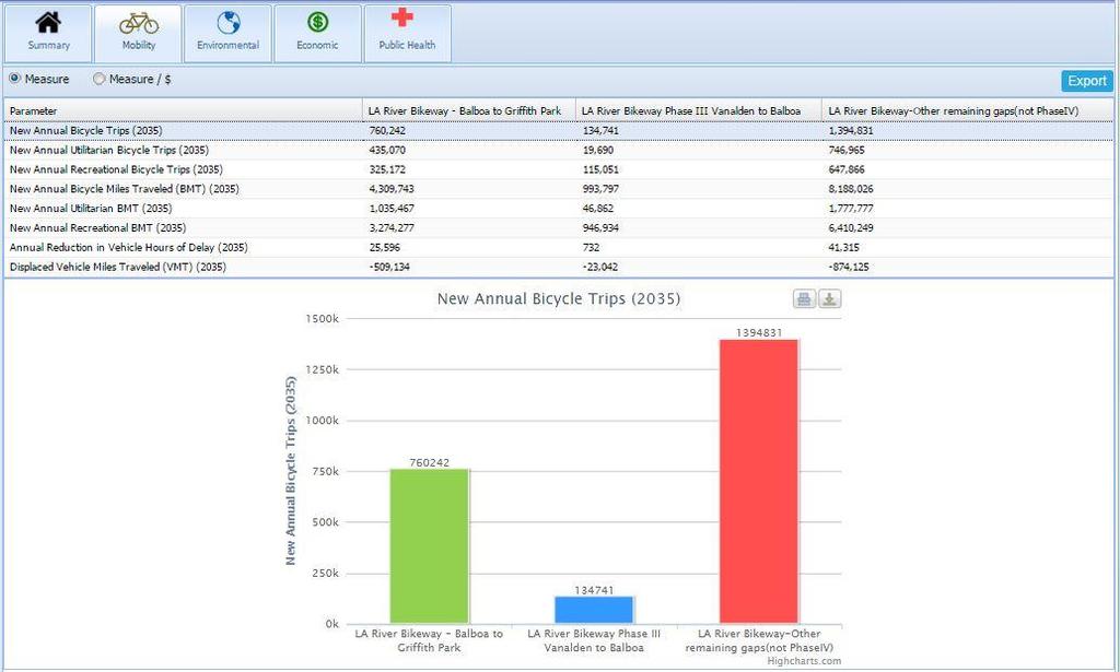
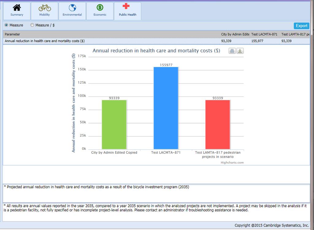
13 Benefits Estimation (2035 vs no build) Benefit Category Description Performance Measure Mobility New Trips New bike trips (work, non-work, rec) # annual trips by purpose New BMT New bicycle miles traveled (w, nw, r) # annual BMT by purpose Reduced VMT Reduction in vehicle miles traveled Reduction in annual VMT Environmental Energy Consumption Reduced vehicle fuel consumption Annual gallons of motor vehicle fuel reduced GHG Emissions Reduced carbon equivalent emissions Annual lbs of GHG reduced Air Pollution Damages Reduced cost of air pollution damages (public health, building repair, agriculture, ecosystems) Annual cost savings as a result of better air quality($) Economic Household Savings Household vehicle O&M cost savings Annual O&M savings ($) Public Health Fitness Benefits Reduced heath care & mortality costs due to increased physical activity & health Annual economic value of public health benefits of added physical activity
14

15 Jurisdiction view of all projects
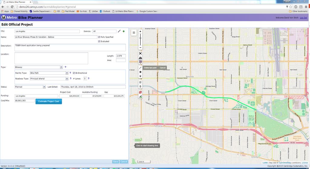
16 Creating/editing a project
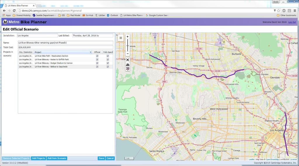
17 Creating/editing scenarios
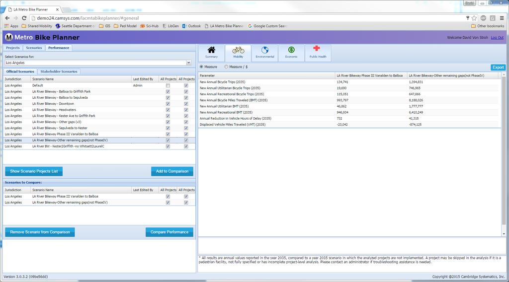
18 Evaluating Performance
19 Scenario Comparison
20 Scenario Comparison
21 Scenario Comparison

22 Export benefits report
 Also exports Esri Shapefile for")
23 Export benefits (cont.) Also exports Esri Shapefile for further offline analysis

24 Contact: William Walter, GISP Questions?
Assessment of socio economic benefits of non-motorized transport (NMT) integration with public transit (PT)
 integration with public transit (PT)") Assessment of socio economic benefits of non-motorized transport (NMT) integration with public transit (PT) Case study of Bike share (BS) system in Pune, India Parvesh Kumar Sharawat Department of Policy
Assessment of socio economic benefits of non-motorized transport (NMT) integration with public transit (PT) Case study of Bike share (BS) system in Pune, India Parvesh Kumar Sharawat Department of Policy
Rerouting Mode Choice Models: How Including Realistic Route Options Can Help Us Understand Decisions to Walk or Bike
 Portland State University PDXScholar TREC Friday Seminar Series Transportation Research and Education Center (TREC) 4-1-2016 Rerouting Mode Choice Models: How Including Realistic Route Options Can Help
Rail Station Fact Sheet CentrePort/DFW Airport Station
 Rail Station Fact Sheet CentrePort/DFW Airport Station Station Overview CentrePort/DFW Airport Station is located by Statler Boulevard at Breezewood Drive in Fort Worth. Free shuttles connect the station
Rail Station Fact Sheet UNT Dallas Station
 Rail Station Fact Sheet UNT Dallas Station Station Overview UNT Dallas Station is located on the east side of University Hills Boulevard in Dallas. t is connected by a walking path to the University of
The Case for New Trends in Travel
 The Case for New Trends in Travel The Future of Cities and Travel Steven E. Polzin, PhD. Center for urban Transportation Research University of South Florida October 19, 2008 Successful Strategies from
Bicycle Demand Forecasting for Bloomingdale Trail in Chicago
 Bicycle Demand Forecasting for Bloomingdale Trail in Chicago Corresponding Author: Zuxuan Deng Arup Water Street, New York, NY 000 zuxuan.deng@arup.com Phone:.. Fax:..0 Matthew Sheren Arup Water Street,
Rail Station Fact Sheet University of Dallas Station
 Rail Station Fact Sheet University of Dallas Station Station Overview University of Dallas Station is located on John Carpenter Freeway and west of Loop 12 across from the University of Dallas in Irving.
Health Impact Analysis for Integrated Regional Land Use and Transportation Plan
 Health Impact Analysis for Integrated Regional Land Use and Transportation Plan Hsi-Hwa Hu, Guoxiong Huang, Frank Wen, Simon Choi (Southern California Association of Governments) Margaret Shih (Los Angeles
Memorandum. Drive alone
 Memorandum To: Cc: From: Kimberly Kerr, Assistant Chief Administrative Officer Natalie Porter, PE, TE Shawna Purvines Claudia Wade, PE Michael Schmitt, AICP CTP, PTP Re: Technical Memorandum #2: Model
Planning Guidance in the 2012 AASHTO Bike Guide
 Planning Guidance in the 2012 AASHTO Bike Guide Presentation by: RJ Eldridge Peter Lagerwey August 22, 2012 WEBINAR 2: PLANNING GUIDANCE IN THE 2012 AASHTO BIKE GUIDE Today s Webinar Significant Updates
A Framework For Integrating Pedestrians into Travel Demand Models
 A Framework For Integrating Pedestrians into Travel Demand Models Kelly J. Clifton Intersections Seminar University of Toronto September 22, 2017 Portland, Oregon, USA Region Population~ 2.4 M Urban Growth
I-105 Corridor Sustainability Study (CSS)
") I-105 Corridor Sustainability Study (CSS) Metro Streets and Freeways Subcommittee March 21, 2019 Gary Hamrick Cambridge Systematics, Inc. I-105 CSS Project History & Background Funded by Caltrans Sustainable
I-105 Corridor Sustainability Study (CSS) Metro Streets and Freeways Subcommittee March 21, 2019 Gary Hamrick Cambridge Systematics, Inc. I-105 CSS Project History & Background Funded by Caltrans Sustainable
Webinar: Development of a Pedestrian Demand Estimation Tool
 Portland State University PDXScholar TREC Webinar Series Transportation Research and Education Center (TREC) 2-18-2016 Webinar: Development of a Pedestrian Demand Estimation Tool Kelly Clifton Portland
OC Healthy Communities Forum. The proportion of the population that live within a half mile of a major transit access point.
 OC Healthy Communities Forum Transit Access The proportion of the population that live within a half mile of a major transit access point. Use of public transit can result in decreased greenhouse gas emissions
An Assessment of Potential Greenhouse Gas Emissions Reductions from Proposed On Street Bikeways
 An Assessment of Potential Greenhouse Gas Emissions Reductions from Proposed On Street Bikeways Through the Sustainable Bethlehem Initiative, the Town of Bethlehem has identified both the improvement of
Multimodal Transportation Plan
 Multimodal Transportation Plan The Multimodal Transportation Plan will accommodate MILLENIALS ARE DRIVING LESS. WE CANNOT BUILD OUR WAY all modes of transportation by keeping pedestrians, OUT OF CONGESTION.
Categorizing Cyclists: What Do We Know? Insights from Portland, OR
 Categorizing Cyclists: What Do We Know? Insights from Portland, OR Jennifer Dill, Ph.D. Professor, Urban Studies & Planning Director, Oregon Transportation Research & Education Consortium (OTREC) Portland
2010 Pedestrian and Bicyclist Special Districts Study Update
 2010 Pedestrian and Bicyclist Special Districts Study Update Pedestrian and Bicyclist Special Districts Program Overview H-GAC s Special Districts Program aims to provide strategic investments in pedestrian
Strategic Plan for Active Mobility Phase I: Bicycle Mobility
 Strategic Plan for Active Mobility Phase I: Bicycle Mobility City of Corpus Christi February 9, 2016 Jeff Pollack, AICP Transportation Planning Director Vision Active Mobility Plan Vision The metropolitan
Bicycle Facilities Planning
 Bicycle Facilities Planning Overview Types of Cyclists Purpose for Riding Types of Facilities Bike Lanes Bicycle Boulevards Cycle Tracks Intersections Signals Signing and Marking Discussion Types of Bicyclists
SUSTAINABILITY, TRANSPORT, & HEALTH. Ralph Buehler, Virginia Tech
 SUSTAINABILITY, TRANSPORT, & HEALTH Ralph Buehler, Virginia Tech Prepared for National Academies Roundtable on Science and Technology for Sustainability 6 December 2013 Overview Trends in Motorization
2017 North Texas Regional Bicycle Opinion Survey
 2017 North Texas Regional Bicycle Opinion Survey Sustainable Development Program Kevin Kokes, AICP Public Meetings April, 2018 North Central Texas Council of Governments MPO for the Dallas-Fort Worth Region
APPENDIX W OFF-MODEL ADJUSTMENTS
 APPENDIX W OFF-MODEL ADJUSTMENTS The three-county travel demand model was used to evaluate the land use and transportation project scenarios for the Regional Transportation Plan Update. The model provided
Stress Bikeway Network
 Building Portland s Low- Stress Bikeway Network Photo credit: Michael Anderson Bikeportland.org Designing Streets 2015 Austin, TX October 29 2015 Roger Geller Portland Background Existing low- and lower-stress
San Mateo County Comprehensive Bicycle and Pedestrian Plan Open House
 San Mateo County Comprehensive Bicycle and Pedestrian Plan Open House October 28, 2010 Presented to San Mateo County residents and interested parties by Lauren Ledbetter, Alta Planning + Design Matt Haynes,
San Mateo County Comprehensive Bicycle and Pedestrian Plan
 San Mateo County Comprehensive Bicycle and Pedestrian Plan August 26, 2010 Presented to the San Mateo County BPAC by Lauren Ledbetter, Alta Planning + Design in association with: Fehr & Peers Eisen Letunic
Public Works AGENDA ITEM D-2 STAFF REPORT
 AGENDA ITEM D-2 Public Works STAFF REPORT Transportation Master Plan Oversight and Outreach Committee Meeting Date: 10/30/2017 Staff Report Number: 17-001-TMP Regular Business: Provide feedback on Performance
Determining bicycle infrastructure preferences A case study of Dublin
 *Manuscript Click here to view linked References 1 Determining bicycle infrastructure preferences A case study of Dublin Brian Caulfield 1, Elaine Brick 2, Orla Thérèse McCarthy 1 1 Department of Civil,
Impact of Shared Mobility and Technology on Public Transportation
 Impact of Shared Mobility and Technology on Public Transportation Susan Shaheen, PhD Email: sshaheen@berkeley.edu Twitter: SusanShaheen1 LinkedIn: Susan Shaheen Overview Defining shared mobility and impacts
Pedestrian Demand Modeling: Evaluating Pedestrian Risk Exposures
 Pedestrian Demand Modeling: Evaluating Pedestrian Risk Exposures Kelly J. Clifton National Center for Smart Growth University of Maryland May 19, 2008 Study Team University of Maryland National Center
DON MILLS-EGLINTON Mobility Hub Profile
 Mobility Hub Profile Dundas Don Mills-Eglinton West-Bloor Anchor Hub Gateway Hub N MOBILITY HUBS: Places of connectivity between regional and rapid transit services, where different modes of transportation
NEWMARKET CENTRE Mobility Hub Profile
 Mobility Hub Profile Dundas Newmarket West-Bloor Centre Anchor Hub Gateway Hub N MOBILITY HUBS: Places of connectivity between regional and rapid transit services, where different modes of transportation
Rail Station Fact Sheet DFW Airport North Station* (*station under construction with anticipated start of service in late 2018)
") Rail Station Fact Sheet DFW Airport North Station* (*station under construction with anticipated start of service in late 018) Station Overview DFW Airport North Station will be located on DFW nternational
Rail Station Fact Sheet DFW Airport North Station* (*station under construction with anticipated start of service in late 018) Station Overview DFW Airport North Station will be located on DFW nternational
Traffic Safety Barriers to Walking and Bicycling Analysis of CA Add-On Responses to the 2009 NHTS
 Traffic Safety Barriers to Walking and Bicycling Analysis of CA Add-On Responses to the 2009 NHTS NHTS Users Conference June 2011 Robert Schneider, Swati Pande, & John Bigham, University of California
Health, Transportation and Bicycling: Connecting the Dotted Lines
 Portland State University PDXScholar Urban Studies and Planning Faculty Publications and Presentations Nohad A. Toulan School of Urban Studies and Planning 11-17-2010 Health, Transportation and Bicycling:
TRANSIT & NON-MOTORIZED PLAN DRAFT FINAL REPORT Butte County Association of Governments
 1 INTRODUCTION Maintaining a high quality of life is the essence of this plan for transit and non-motorized transportation in Butte County. Curbing greenhouse gas emissions (GHG) by reducing congestion,
the 54th Annual Conference of the Association of Collegiate School of Planning (ACSP) in Philadelphia, Pennsylvania November 2 nd, 2014
 in Philadelphia, Pennsylvania November 2 nd, 2014") the 54th Annual Conference of the Association of Collegiate School of Planning (ACSP) in Philadelphia, Pennsylvania November 2 nd, 2014 Hiroyuki Iseki, Ph.D. Assistant Professor Urban Studies and Planning
the 54th Annual Conference of the Association of Collegiate School of Planning (ACSP) in Philadelphia, Pennsylvania November 2 nd, 2014 Hiroyuki Iseki, Ph.D. Assistant Professor Urban Studies and Planning
Urban planners have invested a lot of energy in the idea of transit-oriented
 DOES TRANSIT-ORIENTED DEVELOPMENT NEED THE TRANSIT? D A N I E L G. C H AT M A N Urban planners have invested a lot of energy in the idea of transit-oriented developments (TODs). Developing dense housing
Active and Green: Healthy Communities Are Sustainable Communities
 Active and Green: Healthy Communities Are Sustainable Communities James Sallis, PhD San Diego State University www.drjamessallis.sdsu.edu For LISC Webinar May 4, 2011 Goals of talk Physical inactivity
92% COMMUTING IN THE METRO. Congested Roadways Mode Share. Roadway Congestion & Mode Share
 COMMUTING IN THE METRO Roadway Congestion & Mode Share The majority of major roadways in Greater Des Moines are without congestion and have underutilized capacity. This surplus capacity could be used for
8403 Colesville Road, Silver Spring, Maryland USA Telephone: (240) Fax: (240)
 Fax: (240)") BENEFIT COST & ECONOMIC IMPACT ANALYSIS APPENDIX IN SUPPORT OF THE TIGER V APPLICATION ATLANTA BELTLINE COMMUNITY CONNECTOR CITY OF ATLANTA AND ATLANTA BELTLINE, INC. MAY 30, 2013 Page 1 PROJECT MANAGEMENT,
BENEFIT COST & ECONOMIC IMPACT ANALYSIS APPENDIX IN SUPPORT OF THE TIGER V APPLICATION ATLANTA BELTLINE COMMUNITY CONNECTOR CITY OF ATLANTA AND ATLANTA BELTLINE, INC. MAY 30, 2013 Page 1 PROJECT MANAGEMENT,
TR NEWS. Public Health and Transportation. Innovation, Intervention, and Improvements NUMBER 299 SEPTEMBER OCTOBER 2015
 TR NEWS NUMBER 299 SEPTEMBER OCTOBER 2015 Public Health and Transportation Innovation, Intervention, and Improvements Public Health and Transportation Measuring the Health Benefits of Walking and Bicycling
Toronto Complete Streets Guidelines
 88 90 5.1 Cycling Design Principles 92 5.2 Context-sensitive Cycling Facilities 96 5.3 Key Cycling Elements Cycling infrastructure provides choice in how people are able to move around the city. Cyclists
Bike Routes Assessment: 95 Ave, 106 St & 40 Ave. Replace with appropriate image in View > Master.
 Bike Routes Assessment: 95 Ave, 106 St & 40 Ave Replace with appropriate image in View > Master. Transportation Committee October 15, 2014 City Council Direction What we are trying to achieve The Way Ahead:
Bicycle and Pedestrian Connectivity Study. Old Colony Planning Council
 Bicycle and Pedestrian Connectivity Study Old Colony Planning Council Outline Why consider bike/peds in road designs? Why are measures needed? Connecting Land Use with Transportation Evaluation Tools:
DON MILLS-SHEPPARD Mobility Hub Profile
 DON MILLS-SHEPPARD Mobility Hub Profile Dundas Don Mills-Sheppard West-Bloor Anchor Hub Gateway Hub N MOBILITY HUBS: Places of connectivity between regional and rapid transit services, where different
Rail Station Fact Sheet Downtown Carrollton Station
 Rail Station Fact Sheet Downtown Carrollton Station Station Overview Downtown Carrollton Station is located at East Belt Line Road and Broadway Street near the historic Downtown Carrollton Square. The
How Travel Demand Has Been Changing. Susan Handy Asilomar 2015
 How Travel Demand Has Been Changing Susan Handy Asilomar 2015 Annual VMT per Capita in U.S. 12,000 10,000 8,000 6,000 4,000 2,000-1936 1940 1944 1948 1952 1956 1960 1964 1968 1972 1976 1980 1984 1988 1992
Roadway Bicycle Compatibility, Livability, and Environmental Justice Performance Measures
 Roadway Bicycle Compatibility, Livability, and Environmental Justice Performance Measures Conference on Performance Measures for Transportation and Livable Communities September 7-8, 2011, Austin, Texas
What s Health Got to Do With It? Health and Land Use Planning
 What s Health Got to Do With It? Health and Land Use Planning CANDACE RUTT, PH.D. EXECUTIVE DIRECTOR APRIL 13 TH, 2016 Planning and Public Health Planning + Public Health Healthy Communities Healthier
Climate Change Action Plan: Transportation Sector Discussion Paper: Cycling
 Climate Change Action Plan: Transportation Sector Discussion Paper: Cycling ontario.ca/climatechange Contents 1. Minister of Transportation s message... 3 2. Introduction... 5 3. Sector Overview and Support
Transportation Trends, Conditions and Issues. Regional Transportation Plan 2030
 Transportation Trends, Conditions and Issues Regional Transportation Plan 2030 23 Regional Transportation Plan 2030 24 Travel Characteristics Why Do People Travel? Over one-half of trips taken in Dane
Understanding Travel Modes to Non-work Destinations: Analysis of an Establishment Survey in Portland, Oregon
 Portland State University PDXScholar Dissertations and Theses Dissertations and Theses Spring 6-21-2013 Understanding Travel Modes to Non-work Destinations: Analysis of an Establishment Survey in Portland,
Matt Dykstra PSU MGIS Program
 Matt Dykstra PSU MGIS Program Outline Background Objective Existing Research Methodology Conclusions Significance and Limitations Two-way cycle track: Streetsblog.org Background What is bicycle infrastructure?
Transportation and Health Tool
 Working together to evolve the Transportation and Health Tool APHA Webinar March 22, 2016 Ann Steedly, PE Overview THT Development Context Development of Indicators Strategies, Interventions & Policies
Bike Score: Applying Research to Build Web-Based Tools to Promote Cycling
 Bike Score: Applying Research to Build Web-Based Tools to Promote Cycling Meghan Winters Faculty of Health Sciences Simon Fraser University mwinters@sfu.ca Matt Lerner, Kay Teschke, Mike Brauer Velo-City
Is St. Louis Ready for a Bike Share System? May 14, 2014 Public Open House
 Is St. Louis Ready for a Bike Share System? May 14, 2014 Public Open House PRESENTATION AGENDA 2 BIKE SHARE How does it work? What are the benefits? Who would use it? Will it be safe? Would it work in
Rail Station Fact Sheet CityLine/Bush Station
 Rail Station Fact Sheet CityLine/Bush Station Station Overview CityLine/Bush Station is located just south of the President George Bush Turnpike and east of US 75 in Richardson. The station opened in 00
South Bay Bicycle Master Plan American Planning Association National Conference Los Angeles, CA
 South Bay Bicycle Master Plan 2012 American Planning Association National Conference Los Angeles, CA April 17, 2012 Overview I. Background II. The Importance of Partnerships III. Approach and Success Stories
Active Travel and Exposure to Air Pollution: Implications for Transportation and Land Use Planning
 Active Travel and Exposure to Air Pollution: Implications for Transportation and Land Use Planning Steve Hankey School of Public and International Affairs, Virginia Tech, 140 Otey Street, Blacksburg, VA
Factors influencing choice of commuting mode
 Factors influencing choice of commuting mode Lin Yang J. Aaron Hipp, Deepti Adlakha, Christine Marx, Rachel Tabak, and Ross Brownson Active Living Research February 24, 2015 Active commuting Background
Town of Superior. Superior Trails Plan
 Part 1 Base Information 1. Project Title US 36 Bikeway Extension 2. Project Start/End points or Geographic Area Provide a map with submittal, as appropriate 3. Project Sponsor (entity that will construct/
Methodology for assessing the benefits of active transportation projects EXECUTIVE SUMMARY
 C L I M AT E -S M A R T C I T I E S Methodology for assessing the benefits of active transportation projects EXECUTIVE SUMMARY Written by Eliot Rose and James Choe, ICF International For The Trust for
Infrastructure and Programs. What does the data say? Advancing Non-motorized Transportation in Vermont 11/15/09
 Advancing Non-motorized Transportation in Vermont A reply from the university point of view Lisa Aultman-Hall Professor and Director Figure 4 Why Canadians Cycle more than Americans: A Comparative Analysis
Chapter 4. Gardena. Alta Planning + Design 75
 Chapter 4 Gardena Alta Planning + Design 75 Chapter Four Gardena 76 Alta Planning + Design Los Angeles County Bicycle Coalition and South Bay Bicycle Coalition South Bay Bicycle Master Plan - Draft 4 Gardena
Driverless Vehicles Potential Influence on Bicyclist Facility Preferences
 Driverless Vehicles Potential Influence on Bicyclist Facility Preferences MICHAEL BLAU, MCRP, LCI O T E C O C T O B E R 2 6, 2 0 1 6 S E S S I O N # 8 2 - E V A L U AT I N G T H E P E R F O R M A N C E
Rail Station Fact Sheet Buckner Station
 Rail Station Fact Sheet Buckner Station Station Overview Buckner Station is located at the intersection of Buckner Boulevard and Elam Road in Dallas. The station opened in 2010 and currently serves as
Kevin Manaugh Department of Geography McGill School of Environment
 Kevin Manaugh Department of Geography McGill School of Environment Outline Why do people use active modes? Physical (Built environment) Factors Psychological Factors Empirical Work Neighbourhood Walkability
SUITABILITY STUDY FOR A BICYCLE SHARING PROGRAM IN SACRAMENTO, CALIFORNIA LINDSAY KATHRYN MAURER
 SUITABILITY STUDY FOR A BICYCLE SHARING PROGRAM IN SACRAMENTO, CALIFORNIA by LINDSAY KATHRYN MAURER A Master s Project submitted to the faculty of the University of North Carolina at Chapel Hill in partial
City of Novi Non-Motorized Master Plan 2011 Executive Summary
 City of Novi Non-Motorized Master Plan 2011 Executive Summary Prepared by: February 28, 2011 Why Plan? Encouraging healthy, active lifestyles through pathway and sidewalk connectivity has been a focus
Using GIS and CTPP Data for Transit Ridership Forecasting in Central Florida
 Using GIS and CTPP Data for Transit Ridership Forecasting in Central Florida Xiaobo Liu, Jeffery Stiles Jacobs Engineering Group Mei Chen University of Kentucky For GIS in Transit Conference, 2009 St.
Pre-Plan Consultation Summary
 Transportation Master Plan Pre-Plan Consultation Summary Thursday July 7, 2011 Presentation ti Outline Consultation Objectives Scope of Consultation Who Responded? What did we hear? How well did we connect?
FACTS AND FIGURES: MAKING THE CASE FOR COMPLETE STREETS IN LEE COUNTY
 FACTS AND FIGURES: MAKING THE CASE FOR COMPLETE STREETS IN LEE COUNTY Safety: Close to 5,000 pedestrians and bicyclists die each year on U.S. roads, and more than 70,000 are injured. [Mean Streets, Surface
Update on Regional Bicycle, Pedestrian, & Trail Planning. Presented to TCC November 21, 2014
 Update on Regional Bicycle, Pedestrian, & Trail Planning Presented to TCC November 21, 2014 Survey Measure Assess Focus Area Performance- Driven Process Policy Policy Implement Plan Criteria Criteria Criteria
Community & Transportation Preferences Survey
 Community & Transportation Preferences Survey Webinar: August 5, 2015 Hugh Morris, AICP, LEED Realtor.org Jennifer Dill, Ph.D. trec.pdx.edu 1 Introduction National Association of Realtors Over 1,000,000
REGIONAL HOUSEHOLD TRAVEL SURVEY:
 Defining the Vision. Shaping the Future. REGIONAL HOUSEHOLD TRAVEL SURVEY: Profile Why we travel How we travel Who we are and how often we travel When we travel Where we travel How far and how long we travel
RE-CYCLING A CITY: EXAMINING THE GROWTH OF CYCLING IN DUBLIN
 Proceedings ITRN2013 5-6th September, Caulfield: Re-cycling a city: Examining the growth of cycling in Dublin RE-CYCLING A CITY: EXAMINING THE GROWTH OF CYCLING IN DUBLIN Brian Caulfield Abstract In the
Chapter 2. Bellingham Bicycle Master Plan Chapter 2: Policies and Actions
 Chapter 2 Bellingham Bicycle Master Plan Chapter 2: Policies and Actions Chapter 2: Policies and Actions The Bicycle Master Plan provides a road map for making bicycling in Bellingham a viable transportation
Erfurt, April
 Erfurt, 12.-13. April 2012 www.bicy.it www.bicy.it OVERALL GOAL: Increase & improve cycling in Central Europe Scope: Seven countries, 16 areas (14 cities), 3 years Diverse Strategy: Media, Resources, Events,
Attachment C: Benefit-Cost Analysis Spreadsheet
 Attachment C: Benefit-Cost Analysis Spreadsheet TIGER VII Application Collier Community Streets and Infrastructure Project (CCSIP) June 5 th, 2015 Vanderbilt Drive BCA Summary The Vanderbilt Drive Benefit
City of Jacksonville Mobility Fee Update
 City of Jacksonville Mobility Fee Update 2017 Preliminary Analysis May 3, 2017 Carnival Cruise lines photo credit Presentation Overview Public Outreach Process Pedestrian and Bicycle Master Plan Study
Factors Associated with the Bicycle Commute Use of Newcomers: An analysis of the 70 largest U.S. Cities
 : An analysis of the 70 largest U.S. Cities Ryan J. Dann PhD Student, Urban Studies Portland State University May 2014 Newcomers and Bicycles Photo Credit: Daveena Tauber 2 Presentation Outline Introduction
Low Carbon Mobility Plan For Indian Cities
 Low Carbon Mobility Plan For Indian Cities Data Requirement and BAU Scenario Workshop on Developing Policies and Strategies for Low Carbon Transport in India, 24-25 August, 2012 In Indian context NMT and
Cabrillo College Transportation Study
 Cabrillo College Transportation Study Planning and Research Office Terrence Willett, Research Analyst, Principle Author Jing Luan, Director of Planning and Research Judy Cassada, Research Specialist Shirley
Rail Station Fact Sheet Highland Village/Lewisville Lake Station
 ail Station Fact Sheet Highland Village/Lewisville Lake Station Station Overview Highland Village/Lewisville Lake Station is located on the IH 35 E Northbound Frontage oad at Garden idge Boulevard in Lewisville.
Bicycle Traffic Count Factoring: An Examination of National, State and Locally Derived Daily Extrapolation Factors
 Portland State University PDXScholar Dissertations and Theses Dissertations and Theses Spring 7-25-2013 Bicycle Traffic Count Factoring: An Examination of National, State and Locally Derived Daily Extrapolation
NASHUA REGIONAL PLANNING COMMISSION REGIONAL BICYCLE AND PEDESTRIAN PLAN
 NASHUA REGIONAL PLANNING COMMISSION REGIONAL BICYCLE AND PEDESTRIAN PLAN June, 2005 Prepared by the Nashua Regional Planning Commission 2005 NRPC Regional Bicycle and Pedestrian Plan- JUNE 2005 ACKNOWLEDGEMENTS
ADOT Statewide Bicycle and Pedestrian Program Summary of Phase IV Activities APPENDIX B PEDESTRIAN DEMAND INDEX
 ADOT Statewide Bicycle and Pedestrian Program Summary of Activities APPENDIX B PEDESTRIAN DEMAND INDEX May 24, 2009 Pedestrian Demand Index for State Highway Facilities Revised: May 29, 2007 Introduction
Bike/Multipurpose Trail Study for Glynn County, Georgia MAY 16, 2016
 Bike/Multipurpose Trail Study for Glynn County, Georgia MAY 16, 2016 Agenda» Project Status Update» Draft Recommendations Overview» Next Steps» Questions/Discussion Project Overview» Comprehensive Bikeway
Calculating the ROI of TDM for Physical Activity in Arlington, VA. Sonali Soneji, AICP Simple Solutions Planning & Design, LLC
 Calculating the ROI of TDM for Physical Activity in Arlington, VA Sonali Soneji, AICP Simple Solutions Planning & Design, LLC March 12, 2014 Research Question What is the Return on Investment of Arlington
Chapter 6. Lawndale. Alta Planning + Design 147
 Chapter 6 Lawndale Alta Planning + Design 147 Chapter Six Lawndale 148 Alta Planning + Design Los Angeles County Bicycle Coalition And South Bay Bicycle Coalition South Bay Bicycle Master Plan - Draft
Active Transportation Goals
 Active Transportation Goals - 2017 1. Update shared Regional Priority Bicycle Routes Plan/Map 2. Cities and counties adopt Local Active Transportation Plans [that align with Regional Priority Plan/Map]
National Association of REALTORS National Smart Growth Frequencies
 September 520, 2017 3,000 Weighted Online Respondents National Association of REALTORS National Smart Growth Frequencies Q.2 The first question is about the quality of life in your community. How satisfied
Flyaway Bus: GIS Analysis on Current and Potential Ridership, Revenue, and Prospective Stations
 ProfessorBarry Waite & Bonnie Shrewsbury Flyaway Bus: GIS Analysis on Current and Potential Ridership, Revenue, and Prospective Stations 1. Abstract The Flyaway Bus is a long distance non-stop shuttle
T1-A - Service Reduction (Re-sizing)
") Key T1-A Choice A Key T1-B Choice B Key T1-C Choice C Key T1-D Choice D Key T1-E Choice E Key T1-F Choice F Key Choice G T2 T1-A - Service Reduction (Re-sizing) Description This key choice would represent
Key T1-A Choice A Key T1-B Choice B Key T1-C Choice C Key T1-D Choice D Key T1-E Choice E Key T1-F Choice F Key Choice G T2 T1-A - Service Reduction (Re-sizing) Description This key choice would represent
Bicycle Corrals Portland Designing Streets NYC October 25, 2012 Roger Geller, Bicycle Coordinator Portland, OR
 Bicycle Corrals Portland 8-80 Designing Streets NYC October 25, 2012 Roger Geller, Bicycle Coordinator Portland, OR Build it and they will come 1990 2012 Build it better 2012 background With bike boxes
General Plan Circulation Element Update Scoping Meeting April 16, 2014 Santa Ana Senior Center, 424 W. 3rd Street, Santa Ana, CA 92701
 General Plan Circulation Element Update Scoping Meeting April 16, 2014 Santa Ana Senior Center, 424 W. 3rd Street, Santa Ana, CA 92701 Meeting Agenda 1. Purpose of Scoping Meeting 2. Project Overview 3.
DUNDAS WEST-BLOOR Mobility Hub Profile
 Mobility Hub Profile Dundas West-Bloor Anchor Hub Gateway Hub N MOBILITY HUBS: Places of connectivity between regional and rapid transit services, where different modes of transportation come together
Beyond First First Last Last Mile Strategies. APA National Conference April 3, 2016 Chelsea Richer, AICP Fehr & Peers
 Beyond First First Last Last Mile Strategies APA National Conference April 3, 2016 Chelsea Richer, AICP Fehr & Peers 1 Beyond First Last Mile Strategies APA National Conference Jeremy Klop, AICP, Fehr
Methodology for assessing the benefits of active transportation projects
 C L I M AT E -S M A R T C I T I E S Methodology for assessing the benefits of active transportation projects Written by Eliot Rose and James Choe, ICF International For The Trust for Public Land s Climate-Smart