MOBILE COUNTY COMMISSION DESIGN GUIDELINES for Improving. Existing County Maintained Unpaved Local Roads
|
|
|
- Ezra Pitts
- 6 years ago
- Views:
Transcription

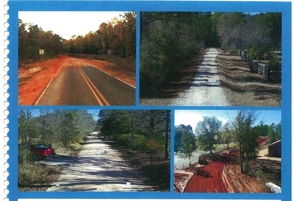
1 4 t MOBILE COUNTY COMMISSION DESIGN GUIDELINES for Improving Existing County Maintained Unpaved Local Roads 2012
2 FORWARD The Mobile County Commission is charged, by law, with authority in relation to the establishment, change or discontinuance of public roads in Mobile County, Code of Alabama, Section The Commission has general superintendence of public roads so as to render travel over such roads as safe and convenient as practicable, Code of Alabama, Section The Commission is vested with the authority to establish, promulgate and enforce rules and maintenance of its public roads, Code of Alabama, Section The Commission has found that existing design policies do not recognize or adequately address the uniqueness of the unpaved road system maintained by the Mobile County Commission. Existing policies often require design elements not suited for conditions found in Mobile County and often advocate expenditure of funds for design elements that neither improve the efficiency nor enhance the safety of the types of unpaved roads found in Mobile County. Therefore, the Mobile County Commission has found it to be in the public s best interest to promulgate a guide on roadway design for paving existing unpaved local roads within Mobile County. Pursuant to the direction of the Mobile County Commission, the Engineering Department has prepared a guide on roadway design for the purpose of paving existing unpaved roads. The intent of this guide is to set the general roadway design elements for roadway construction directed by the Mobile County Commission. The design elements contained within this guide come from various engineering sources, technical publications, research studies, applied engineering judgment and current public acceptance within Mobile County. The intent of this guide is to create a safe roadway system at a reasonable cost, to give the citizens of Mobile County the best benefit/cost ratio possible, and to serve all the areas within the county with the ultimate goal of paving all existing roadways in Mobile County. Aesthetic, historic, and cultural resource impacts of the roadway design are to be principal considerations within this guide. This guide does not apply to the general maintenance of roads, but does apply to the paving of existing county maintained unpaved roads. This guide does not constitute a fixed standard, rule or regulation. As with any guide, it is meant as a guide and is not intended to be a substitute for sound engineering judgment. This guide recognizes that deviations from the terms of this guide may be necessary and warranted in the exercise of sound engineering judgment. I
3 C -o 0) Cu C 0 C4 C I- a) C a) Ct Cl) -C I-


4 This guide will go into effect upon commission approval and will be applied to any project that is initiated after this date for the paving of an existing county maintained unpaved road in the unincorporated section of Mobile County. This guide will also be utilized for design of unpaved roadways accepted in Mobile County s Dirt Road Program (DRP). This guide will remain in effect pursuant to the direction of the Mobile County Commission and can only be altered, changed, or amended by a majority vote of the commission. Approved by the Mobile County Commission: On this 22. day of 2012 Commisserudgood Commiss oner Connie Hudson Commissioner Mike Dean 3
5 CD CD ( (c ((Cc( ( ( ( (.( ccc c ( c ( ( I I ( ( ( ( (
6 Mobile County Commission Design Guidelines for Paving Existing County Maintained Unpaved Local Roads Table of Contents Forward Chapter 1 11 General Terms! Elements for Design 1.1 ClearZone 1.2 Context Sensitive Solutions 1.3 Drainage Erosion Control Requirements.5 Functional Classification 1.6 LateralOffset 1.7 Roadway 1.8 Temporary Traffic Control 1.9 Traffic Calming 1.10 Traveled Way 1.11 Typical Traveled Way Cross Section 1.12 Vertical Clearance Chapter Elements of Design for Major Local Roads 2.1 Roadway Design 2.2 Stopping Sight Distance 2.3 Intersection Sight Distance 2.4 Horizontal Alignment 2.5 Vertical Alignment 2.6 Cross Slope 2.7 Drainage 5
7 Chapter Elements of Design for Minor Local Roads and Residential Roads 3.1 Roadway Design 3.2 Stopping Sight Distance 3.3 Intersection Sight Distance 3.4 Horizontal Alignment 3.5 Vertical Alignment 3.6 Cross Slope 3.7 Drainage Chapter Elements of Design for Access Roads 4.1 Roadway Design 4.2 Stopping Sight Distance 4.3 Intersection Sight Distance 4.4 Horizontal Alignment 4.5 Vertical Alignment 4.6 Cross Slope 4.7 Drainage Chapter Elements of Design for Access Ways 5.1 Roadway Design 5.2 Stopping Sight Distance 5.3 Intersection Sight Distance 5.4 Horizontal Alignment, Vertical Alignment and Cross Slope 5.5 Drainage 6
8 Chapter Functional Classification 6.1 Arterial and Collector Road General Characteristics 6.2 Local Road General Characteristics 6.21 Major Local Road 6.22 Minor Local Road 6.23 Residential Road 6.24 Access Road 6.25 Access Way 6.3 Reevaluation of the System Chapter Design Waiver References 61 7
9 H HJ )j) ))J) )L)J)H..0 Cu 0 C) C C) acu Cl) I-
 o 1 CD")
10 CD 3C) CD c_) CD C1) o 1 CD CD -
11 CHAPTER 1 1. General Terms I Elements for Design The following information will be included in the design for paving existing county maintained unpaved local roads. 1.1 ClearZone The clear zone is the traversable area provided beyond the edge of the traveled way for the recovery of errant vehicles. Any vertical obstructions in this area shall be breakaway devices or shall be shielded. For traveled ways with design speed greater than 30 mph the clear zone shall be the same as the shoulder widths as shown in this guide. For traveled ways with design speed 30 mph, clear zone criteria shall not apply. 1.2 Context Sensitive Solutions Context sensitive solutions (CSS) are theoretical and practical approaches to transportation decision-making and design that takes into consideration the communities and lands which streets and roads pass through ( the context ). These streets and roads should fit the physical setting and preserve scenic, aesthetic, historic, natural, and environmental resources, while maintaining safety and mobility (being sensitive to location). Projects involve efficient and effective use of resources (time, budget, community) with minimal disruption to the community. All stakeholders involved in a project should communicate and collaborate to achieve a design that meets most expectations. 1.3 Drainage All drainage design shall conform to the Mobile County Flood Damage Prevention Ordinance. The purpose of this ordinance is to promote public health, safety, and general welfare, and to minimize public and private losses due to flood conditions. 1.4 Erosion Control Requirements All projects shall include the current requirements of NPDES. Reference the current edition of the Alabama Handbook for Erosion Control, Sediment Control, and Stormwater Management on Construction Sites and Urban Areas. All devices shall be clearly defined and quantified, including all applicable directions, notes and associated references to perform the construction. 11
12 1.5 Functional Classification Functional classification is the grouping of streets, roads, and ways by the character of service they provide. The functional classification of each road shall be noted on the plans. 1.6 LateralOffset Lateral offset is the area adjacent to the traveled way clear of all vertical obstructions such as signs, utility poles, luminaire supports, fire hydrants, etc., including breakaway devices. For this guide the lateral offset shall be 1.5 feet from the traveled way. 1.7 Roadway The roadway is the total composition of all design elements including the traveled way, shoulder, and drainage system. I 8 Temporary Traffic Control All projects shall include a temporary traffic control plan and will conform to the current edition of the MUTCD, Manual on Uniform Traffic Control Devices, Part VI. All devices shall be clearly defined and quantified, including all applicable directions, notes and associated references to perform the construction. 1.9 Traffic Calming Traffic calming involves design elements that incorporate changes in street alignment, installation of barriers and other physical measures to reduce traffic speeds and/or cut-through volumes, in the interest of street safety, livability, and other public purposes Traveled Way Traveled way is the portion of the roadway, exclusive of the shoulders and drainage system, which is used for the movement of vehicles. 12
13 1.11 Typical Traveled Way Cross Section Roadways for this guide may include the following cross section types: Open Ditch Curb and Gutter Roll Curb Asphalt Wing Inverted Crown No-Crown I Single Slope 1.12 Vertical Clearance Shoulders and traveled way should be clear of obstructions 16 feet above their surface. Any locations that cannot achieve the required vertical clearance shall be marked with appropriate traffic control devices. For traveled ways with design speed 30 mph the vertical clearance criteria shall not apply. 13
14 - CD C) CD 0 C) C) CD U) )_) _) ) ) ) J 1) ) ) _) )) i ) ) J) ) ))

15 Chapter 2 Elements of Design for Major Local Roads
16 CHAPTER 2 2. Elements of Design for Major Local Roads The following roadway design criteria will be used for existing county maintained unpaved roads functionally classified as Major Local Roads. The design speed for this classification should be in the mph range. Under warranted situations lower design speeds may be used only with approval by Mobile County Engineering Department. Right-of-way width should be a minimum of 60 feet, unless the environment which it serves restricts the acquisition to a lesser width. 2.1 Roadway Design On some open-ditch type roadways I - 2 feet of paved shoulder may be approved by Mobile County Engineering Department. If approved, this paved area shall have the same cross slope as the traveled way, but would be considered as part of the shoulder width. I -750 ADT Design Speed Traveled Way Width Shoulder Width Clear Zone (mph) (feet) Minimum (feet) Minimum (feet) 15to n/a 35to For roadways with design speeds 30 mph clear zone shall not apply (n/a). Curb and gutter section roadways shall have a 1.5 feet clear zone measured from the face of curb ADT Design Speed Traveled Way Width Shoulder Width Clear Zone (mph) (feet) Minimum (feet) Minimum (feet) 15to n/a 35to For roadways with design speeds 30 mph clear zone shall not apply (n/a). Curb and gutter section roadways shall have a 1.5 feet clear zone measured from the face of curb. 17
17 Design Speed Traveled Way Width Shoulder Width Clear Zone (mph) (feet) Minimum (feet) Minimum (feet) 15to n/a For roadways with design speeds 30 mph clear zone shall not apply (n/a). Curb and gutter section roadways shall have a 1.5 feet clear zone measured from the face of curb. Design Stopping Sight Stopping Sight Stopping Sight Speed Distance for Distance for Distance for Level Roadways Downgrades Upgrades (feet) (feet) (feet) (mph) <3% 3% 6% 9% 3% 6% 9% Formula source: AASHTO, A Guide on Geometric Design of Highways and Streets (3-3) Stopping sight distance shall be calculated on a driver eye height of 35 feet to an object height of 2 feet. The shoulder area shall not be utilized to determine the sight distance length. Where a site specific location has a stopping sight distance less than the calculated distance condition. 18 based on the design speed, traffic control devices shall be installed to alert the driver of the 30((3:2)±G) d= Distances should be adjusted for grades steeper than those shown. 2.2 Stopping Sight Distance >2000 ADT
18 2.3 Intersection Sight Distance (mph) (feet) Distances shown are for a passenger (P) design vehicle making a left turn maneuver onto a main road and may require additional distance for a larger design vehicle. For reference use: Guide on Geometric Design of Highways and Streets, Chapter Table 9-6. AASHTO, A 9, Intersections, Speed shown (mph) is the speed the vehicle is traveling along the main road and the distance shown (feet) is from the side road to the vehicle on the main road. Intersections that do not meet minimum distance may require an advisory intersection and speed sign. Distances shall be adjusted for grades more than 3 %. For reference use: AASHTO, on Geometric Design of Highways and Streets, Table 9-4, Adjustment Factors for Sight Distance Based on Approach Grade. A Guide 2.4 Horizontal Alignment Rmin = V2 15 ( O.Olemax+fmax) Formula source: AASHTO, A Guide on Geometric Design of Highways and Streets (3-8) Centerline Radius (feet) Minimum Design Speed (mph) Cross Slope (%) fmax , , ,085 19
19 20 Maximum grade for traveled way shall be 12%. difference in intersecting grades (A). K = LIA Rate of vertical curvature, K, is the length (L) of curve divided by the percent algebraic Design Speed K Value for Crest K Value for Sag 2.5 Vertical Alignment Cross Slope (%) fmax (mph) Vertical Curves Vertical Curves Design Speed (mph) Centerline Radius (feet) Minimum emax =.06 (Urban Area) emax.08 (Rural Area) Superelevation
20 2.6 Cross Slope Pavement Cross Slope Open Ditch 2.0% - 2.5% Curb and Gutter 2.0% - 2.5% Roll Curb 2.0% - 2.5% Asphalt Wing 3.33% (typical) Grass Shoulder Cross Slope 4% - 6% 2% if adjacent to sidewalk Front Slope Desirable Maximum 3: 2: 1 1 Back Slope Desirable 1 Maximum I : 1 3: 2.7 Drainage Side Drain or Lateral Storm Sewer Minimum 10 yr. storm Crossing (Closed) Storm Sewer Minimum 10 yr. storm Sump Crossing (Closed) Storm Sewer Minimum 25 yr. storm Culvert (Open) Cross Drainage Minimum 25 yr. storm Bridge or Bridge Culvert * * All Bridge or Bridge Culvert requires Minimum 50 yr. storm HS-20 Structural Design. Drainage to 1 foot. designed than structures pass located within a federally 100 a minimum of a 100 storm without raising year designated year base the base elevation should be flood elevation more 21
21 ))): )) ))) )) ) )) ) ).).) )) -.0 a) C 0 C a) C 0) I-
 CD -I")
22 mi u) O0 C) CD -I CA) m m
23 CHAPTER 3 3. Elements of Design for Minor Local Roads and Residential Roads The following roadway design criteria will be used for existing county maintained unpaved roads functionally classified as Minor Local Roads and Residential Roads. The design speed for these classifications should be in the mph range. Traffic calming elements should be incorporated to keep roadway users from traveling at speeds higher than the design speed. Under warranted situations for Minor Local Roads only, higher design speeds >30 mph may be used, only with approval by Mobile County Engineering Department. Design speed for Minor Locals Roads >30 mph shall follow the guidelines of Chapter 2, Elements of Design for Major Local Roads. Context sensitive solutions should be incorporated in areas that are highly developed or that have an isolated location that should be preserved. Right-of-way width should be a minimum of 30 feet, unless the environment which it serves restricts the acquisition to a lesser width. The following criteria are intended to be designed within the existing right-of-way, but may require additional right-of-way at site-specific locations for roadway elements and/or for utility relocations adjacent to the roadway. 3.1 Roadway Design * Design Speed for Minor Locals Roads >30 mph shall follow the guidelines of Chapter 2, Elements of Design for Major Local Roads Design elements such as horizontal and vertical curves, traffic calming devices, short tangent lengths, etc., should be incorporated to reduce high running speeds. Some locations may require additional pavement width such as on the inside of horizontal curves with small radii or at site-specific locations that will reduce the need for future maintenance (drainage outfalls, driveways, intersections, etc.). 25
24 Maximum grade for traveled way shall be 16%. 28 difference in intersecting grades (A). K = L/A Rate of vertical curvature, K, is the length (L) of curve divided by the percent of algebraic K Value for Crest Vertical Curves K Value for Sag Vertical Curves (mph) Design Speed 3.5 Vertical Alignment f max Cross Slope (%) Design Speed (mph) Centerline Radius (feet) Minimum Formula source: AASHTO, A Guide on Geometric Design of Highways and Streets (3-8) 15 ( O.Olemax+ fmax) Rmin = V2 3.4 Horizontal Alignment
25 3.6 Cross Slope Pavement Cross Slope Open Ditch 2.0% - 2.5% Curb and Gutter 2.0% - 2.5% Roll Curb 2.0% - 2.5% Asphalt Wing 3.33% (typical) Inverted Crown 2.0% - 4.0% No-Crown I Single Slope 4.0% (max) Grass Shoulder Cross Slope 4% - 6% 2% if to sidewalk Should match No-Crown I Single Slope adjacent pavement cross slope for Front Slope: Desirable 3 : 1 Maximum 1 2: Back Slope: Desirable 3 : 1 Maximum 1 : Drainage Side Drain or Lateral Storm Sewer Minimum 10 yr. storm Crossing ( Closed ) Storm Sewer Minimum 10 yr. storm Sump Crossing (Closed) Storm Sewer Minimum 25 yr. storm Culvert ( Open ) Cross Drainage Minimum 25 yr. storm Bridge or Bridge Culvert * Minimum 50 yr. storm * All Bridge or Bridge Culvert requires HS-20 Structural Design. Drainage to 1 foot. designed than structures pass located within a federally 100 a minimum of a 100 storm without raising the year designated year base base elevation should be flood elevation more 29
26 ot: ueq gal AIIeuopua;u abed sq
 G) C.")
 I 0.")
27 - LU (I) C.) G) C.) I a) 0. 0 G) I 0.
28 CHAPTER 4 4. Elements of Design for Access Roads The following roadway design criteria will be used for existing county maintained unpaved roads functionally classified as Access Roads. Roads for this classification are typically twodirectional one-lane roads and should have an ADT of 400. The design speed for this classification should be in the mph range. Traffic calming elements should be incorporated to keep roadway users from traveling higher than the design speed. Context sensitive solutions should be incorporated in areas that are highly developed or that have an isolated location that should be preserved. In context sensitive areas, especially where an established path has been used by the community that it serves, right-of-way width should conform to the surroundings. Right-of-way width in some areas may be the same as the roadway width, and may only include the prescriptive area of the roadway. The following criteria are intended to be designed within the existing right-of-way currently available, but may require additional right-of way at site-specific locations for roadway elements and/or for utility relocations adjacent to the roadway. 33
29 4.1 Roadway Design Design Speed Traveled Way Width Shoulder Width (mph) (feet) Minimum (feet) Minimum The shoulder area may have paved turnouts that parallel the traveled way at sharp curves, at spacing intervals of approximately feet., or at other appropriate areas like driveways, for the purpose of allowing vehicles to pass with minimal backing. Wider shoulders should be used wherever possible unless right-of-way constraints, or context sensitive solutions restrict their use. Design elements along the roadway such as horizontal and vertical curves, traffic calming devices, short-tangent lengths, etc., should be considered to reduce high running speeds. Some locations may require additional pavement width such as on the inside of small-radii horizontal curves or at site-specific locations that will reduce the need for future maintenance (drainage outfalls, driveways, intersections), etc. Consideration should be given at intersections to widen to two-lane widths with appropriate radii to accommodate the vehicle design-type. 4.2 Stopping Sight Distance L Stopping Sight Sight Distance Sight Distance Distance for Adjustment for Adjustment for Level Roadway Downgrades Upgrades Design Speed (feet) (feet) (feet) (mph) Level 3% 6% 9% 3% 6% 9% Stopping Sight Distances are calculated based on the driver s eye height of 3.5 feet. to an object height of 2 feet. The shoulder shall not be used as part of the sight distance length. Under extreme circumstances, where a site-specific location has a stopping sight distance less than the design speed for the entire project, traffic control devices may be used to alert the driver of this condition. For grades steeper than those shown adjustment should be made. c 34
30 d 30(( a V \\ 32.2 / Formula source: AASHTO, A Guide on Geometric Design of Highways and Streets (3-3) 4.3 Intersection Sight Distance Posted Speed (mph) Limit Intersection Sight Distance (feet) Distances shown are for a passenger (P) design vehicle making a left turn maneuver onto a main road and may require additional distance for larger design vehicles. For reference use: AASHTO, Table 9-6. A Guide on Geometric Design of Highways and Streets, Chapter 9, Intersections, Speed shown (mph) is the speed the vehicle is traveling along the main road and the distance shown (feet) is from the side road to the vehicle on the main road. Intersections that do not meet minimum distance may require an advisory intersection and speed sign. Distances should be adjusted for grades more than 3 %. Intersection of the side road to the main road should be widened to allow two-lanes of operation for ingress and egress (to the side road). If both roadways are two-directional one lane roadways all directions should be considered to widen to two-lane widths, allowing a place to pull over and pass each other before continuing. 35
31 Horizontal Alignment Centerline Radius Design Speed (mph) Minimum Radius (feet) Minimum Additional Pavement Width Required for Curves If the road will have a school bus, garbage truck, other large single unit vehicles, or a vehicle pulling a trailer (boat, utility, etc) on a regular basis, additional width of pavement will be necessary to keep off-tracking onto the shoulder to a minimum. The additional pavement width should be considered to be placed on the inside area of the radius. Radius (feet) >950 loft.lane nla 12 ft. Lane 2 1 nla nla nla 4.5 Vertical Alignment Design Speed K Value for Crest K Value for Sag (mph) Vertical Curves Vertical Curves 10 2 n/a Rate of vertical curvature, K, is the length of curve divided by the percent algebraic difference in intersecting grades (A). K = LIA Maximum grade for traveled way shall be 16%. 36
32 4.6 Cross Slope Pavement Cross Slope Match existing topography (4.0% max) Grass Shoulder Cross Slope Match pavement cross slope Front Slope Desirable 3 Maximum 2: : 1 1 Back Slope Desirable 3: Maximum I : 1 I 4.7 Drainage determined that sensitive solution for the area. Some site-specific drainage improvements may be determined and incorporated into the design of the roadway by the engineer without a Drainage may match existing topography comprehensive drainage system. if it would be a context If drainage is used, the following should apply: Side Drain or Lateral Storm Sewer Minimum 2 yr. storm Crossing ( Closed ) Storm Sewer Minimum 2 yr. storm Sump Crossing (Closed) Storm Sewer Minimum 10 yr. storm Culvert ( Open ) Cross Drainage Minimum 10 yr. storm Bridge or Bridge Culvert * Minimum 50 yr. storm * All Bridge or Bridge Culvert requires HS-20 Structural Design. Drainage structures located within a federally designated 100 year base elevation should be designed to pass a minimum of a 100 year storm without raising the base flood elevation more than 1 foot. 37
33 RE ueq uai Aeuopua;u abed sq

34 Chapter 5 Elements of Design for Access Ways
35 CHAPTER 5 5. Elements of Design for Access Ways The following roadway functionally classified roads design criteria will be as Access Ways. used for existing county maintained unpaved An Access Way shall be paved only if it directly to an existing paved road. It may be paved if jointly with a roadway paving project will a continuous paved route to an existing paved road. associated connects that create Roads for this classification typically two-directional and should have an ADT of 200. ADT for this classification of roadway is an of trips by the local property and their If the of any property to this type of roadway is going to unfamiliar with this to travel with frequency, different criteria should be design users are guests. encourage users considered. purpose one-lane roads aggregate area repeated adjacent A moderate to high housing should be with this type of roadway and should 1 for every 125 linear feet of roadway, or (maximum of 18 Road length should be no than 1/3 mile (1700 feet). An Access Way may divide to different properties, or loop back onto itself. of the roadway may different road given for and may constitute a housing density. of roadway provide additional property and should be part of the Access Way. average have access house about names These segments considered density greater the about associated addressing purposes, less These segments adjacent lesser access houses). The design speed for this classification should be 10mph. Context sensitive solutions should be incorporated for this type of roadway. The and to property this type of road should be In context with a minimal history, especially where an Access Way by the community it right-of-way width should conform to the surroundings. nature access sensitive areas, established that crash that serves, serves preserved. secluded has been Right-of-way width in may be the roadway width, and may only include the prescriptive of retain the width that Mobile County intended to be within existing right-of-way, but may require additional right-of-way at site-specific locations for roadway for utility relocations to the way. designed the some areas area elements and/or same as the the Access Way. Prescriptive right-of-way roadways should are has maintained. The following criteria adjacent 41
36 5.1 Roadway Design Design Speed Traveled Way Shoulder Width Maximum Width 10 mph Existing Travel Width Existing Width (Maximum 14 feet) Areas along the Access Way may include additional site-specific paved areas wider than the maximum shown to aid possible conflicting traffic or roadway maintenance locations. Some locations may be at sharp curves, drainage structures, intersections, driveways, or at other appropriate areas. Some areas may be for the purpose of allowing vehicles to pass with minimal backing. 5.2 Stopping Sight Distance Stopping Sight Distances are calculated based on the driver s eye height of 3.5 feet to an object height of 2 feet. The shoulder area may be utilized to determine the sight distance length. The minimum stopping sight distance shall be 40 feet. Site specific locations may have traffic control devices installed to alert the driver. 5.3 Intersection Sight Distance Intersections shall be evaluated based on their functional classification and posted speed limit. An Access Way that intersects another Access Way should have the same intersection sight distance as stopping sight distance, 40 feet. On Access Ways that intersect roads which are functionally classified other than an Access Way, the following intersection sight distance table should be used. Posted Speed Limit Main Road Intersection Sight Distance Along Main Road (mph) (feet) Distances shown in the table are for a passenger (P) design vehicle making a left turn maneuver onto a main road and may require additional distance for larger design vehicles. Speed shown (mph) is the speed the vehicle is traveling along the main road and the distance 42
37 shown (feet) is from the centerline of side road to the vehicle on the main road. Intersections that do not meet minimum distance may require an advisory intersection and speed sign to be posted on the main road. 5.4 Horizontal Alignment, Vertical Alignment and Cross Slope Access Ways should match existing topography. 5.5 Drainage Drainage should match existing topography. Typically no drainage improvements are required. If determined that context sensitive drainage solutions for the area should be included, sitespecific drainage improvements may be incorporated. If the drainage system is improved, the design should accommodate the following drainage criteria: Side Drain or Lateral Storm Sewer Minimum 2 yr. storm Crossing ( Closed ) Storm Sewer Minimum 2 yr. storm Sump Crossing (Closed) Storm Sewer Minimum 10 yr. storm Culvert ( Open ) Cross Drainage Minimum 10 yr. storm Bridge or Bridge Culvert * Minimum 50 yr. storm * All Bridge or Bridge Culvert requires HS-20 Structural Design. Drainage structures located within a federally designated 100 year base elevation should be designed to pass a minimum of a 100 year storm without raising the base flood elevation more than 1 foot. 43
38 171 ueq je AIIeuo!ueu! abed sq
 Cu I")
39 l4 CD 4-0. ci E Cl) Cu I -r-r-rrr r -r
40 CHAPTER 6 Functional Classification The classification of local roadways into different functional classes is necessary for communication among engineers, local agencies, and the general public. Different classifications apply for different purposes in both the rural and urban environment. Functional classification, the grouping of streets / roads by the character of service they provide, is the main purpose in planning, designing, meeting social needs, and establishing funding. The functional classification of roads and streets is an important management tool in the establishment of realistic improvements both for individual roadways and for the county road system as a whole. The idea is to combine adequacy with economy and to attain a rural road or urban street system giving the highest overall level of service per dollar of investment. A complete functional roadway system provides the motoring public with a series of distinct travel movements. From main movement at the national level, to the termination movement at an isolated location at the rural level, the function of each type of roadway should be designed and planned in a distinctly different manner. According to the guidelines as established in AASHTO, A Guide on Geometric Design of Highways and Streets, Current Edition, the current concept of a complete highway system consists of six stages or movements. In most cases these stages are main, transition, distribution, collection, access, and termination. In some cases, the termination of a trip may exclude some of these movements. (See fig. 6.1) Main movement involves the transportation of the highest volumes of vehicular traffic on freeway and primary arterial systems at national and state levels. Examples of this include roads like the Interstate System (1-10 and 1-65), U.S. Highway System ( U.S. Hwy 45, U.S. Hwy 98, State Hwy 188). This level requires the highest design standards for mobility and safety, while limiting access points throughout its entire system. Transition movement is the first step in directing traffic from a national, state, or inter-county level roadway system to the local environment level. The transition movement includes minor arterial and collector systems. Examples of this include roads like Lott Rd., Airport Blvd., Schillinger Rd., and Cottage Hill Rd. Transition movement design requires the designer or planner to start allocating for the need of public access to property. However mobility at this level is still the primary focus. Distribution movement consists of a broad spectrum of vehicular traffic trying to access a wide variety of major and minor collector and various local roads in a county-wide system. Examples of this include roads like Prine Rd., Spice Pond Rd., Tanner Williams Rd., and Bellingrath Rd. The demand for public access to property becomes varied and is the main focus in design. Mobility is restricted at different levels and for different purposes. The collection movement, access movement and termination movement constitute the rest of the various local road systems. Transportation at this level involves the movement of a wide variety of vehicular types to and from a wide variety of destinations. Access is the main focus for the design, blending with the movement with the various types of design vehicles. Such movement can range from high-density work or school traffic, to a single vehicle destined for a boat ramp on an isolated rural road (way). The design of these roads may and will vary considerably. 47


41 MAIN MOVEMENT FREEWAYS - ART ERIALS High MobUity - to Restricted Access MINOR LOCAL ROADS RESIDEN11AL ROADS ACCESS ROADS ACCESS WAYS COLLECTION MOVEMENT VARIOUS MAJOR, MINOR LOCAL ROADS & RESIDENTIAL ROADS Moderate to Minimal Mobility - to Modemte Access MINIMAL ACCESS TERMINATION POINT TRANSITION MOVEMENT ARTERIALS - COLLECTORS MODERATE ACCESS TERMINATION POINT High to Moderate Mobility - to Limited Access DISTRIBUTION MOVEMENT COLLECTORS - MAJOR LOCAL ROADS HIGH ACCESS TERMINATION POINT Moderate Mobility - to Minimal Access ACCESS MOVEMENT MINOR LOCAL ROADS RESIDENTIAL ROADS ACCESS ROADS ACCESS WAYS Minimal to Restricted Mobility - Access Relationship of Functionally Classified Systems afficmobiiity MAIN ACCESS TERMINATION POINT HIGHWAY SYSTEM OF MOVEMENT (Hg. 61) 48 High Limited High Moderate Minimal
42 The first step roadway boundary areas. AASHTO, in developing road classifications is to determine limits of urban and rural A Guide on Geometric Design of Highways and Streets, Current Edition, defines urban areas as all areas which have a population greater than 5,000 or more. Urban areas are further subdivided into urbanized areas (population of 50,000 and over) and small urban areas (population between 5,000 and 50,000). All other areas which have a lesser population are rural. The Alabama Department of Transportation has established by code (Section 101 of Title 23, U.S. Code) the boundary of Mobile County that has an urbanized area. In both the rural or urban areas all the vehicular movement levels occur, but the vehicular densities and the access to properties vary considerably. The quantity of vehicular traffic does not determine an urban area iust as the use of land does not determine a rural area. The next step in developing road classifications is to determine the general characteristics of the road. Some of the general characteristics would include linkage with other roads, the service it provides to the area, design speeds, access to property, truck usage, and level of service. The current roadway system, as recognized by NACE and defined by AASHTO, designates four basic classifications: Principal Arterial, Minor Arterial, Collector (Major and Minor) and Local. (See fig.6.2) Functional Classification System Urban Area Urban Mileage (Percent) Rural Area Rural Mileage (Percent) Principal Arterial System 5-10 Principal Arterial System 2 4 Principal Arterial plus Minor Arterial System Principal Arterial plus 6 12 Minor Arterial System Collector System 5-10 Collector System Local System Local System (Source: AASHTO, A Guide on Geometric Design of Highways and Streets, Table 1-1 and Table 1-2) (Fig. 6.2) 6.1 Arterial and Collector Road General Characteristics N 6.11 Principal Arterial A. B. Major link from state to state Provide high mobility for longer trips C. Access is limited to other roads only and rarely to property D. Design speeds are high, mph E. Truck usage is high and will accommodate the largest vehicle type F. Level of Service B desirable 49
43 6.12 Minor Arterial A. Majorlinkwithin state orcounty level B. Serves as high traffic corridor to primary arterials C. Provide high to moderate mobility for moderate trips D. Access to abutting property should be limited and sometimes restricted E. Design speeds are moderate to high, mph F. Truck usage is high with possible restrictions in vehicle type G. Level of Service C desirable 6.13 Collector A. Major link within county B. Serves as major traffic generator not directly served by arterials C. Spaced at intervals that accumulate traffic for local road systems D. Provide moderate mobility within county E. Access to abutting property is minimal to limited F. Design speeds are moderate to low mph Note: low speeds mph should only be used in mountainous terrain G. Truck usage is moderate with some restrictions in vehicle type H. Level of Service C to D desirable 50
44 6.2 Local Road General Characteristics The Local Road functional classification is the next level and approximately 65-80% of total roadway mileage. on AASHTO this classification the criteria However, not all Local or should have the in design, function, and environment. of diversity in following local road classifications have County. fig. 6.3) by Mobile the design characteristics characteristics, the (See characteristics. Based Roads have Because constitutes the has been established Local Road Functional Classification same general same Local Roads Urban Rural Mileage Mileage (Percent) (Percent) Major Local Roads MinorLocaiRoads Residential Roads Access Roads Access Ways Major Local Road (Fig.6.3) This classification of roadway is the local level links to equal or higher functional classification at end. It may also include roadways link isolated or like subdivisions, industrial or recreational in urban or commercial farms, timberlands, small communities, residential industrial or recreational in rural to higher functional classification roadways. (developed areas roadways planned) areas sites highest each areas that that sites areas, A. Serves as a link equal or higher functional classification roadways, or may loop into an isolated and to the type of roadway between area reconnect same B. Serves as a link to communities or significant typically only connecting roadway from a higher classification roadway serves as the areas within a jurisdiction, or C. Access to abutting property is moderate to high D. Design Under speeds are moderate, some mph conditions a lower design speed may be considered E. Right-of-way width should be a minimum of 60 feet, environment which it restricts acquisition to a serves the unless the lesser width F. Truck usage is moderate to high G. The level of service should provide moderate traffic flow times of heavy and may have restrictions congestion 51 passing except during
45 6.22 Minor Local Road This classification of roadway links isolated areas to a higher functional classification roadway. Isolated areas may be areas where the road extends to; a business, recreational area, scenic place, agriculture / land management areas, industrial site, or to a minimal number of houses. A. Links isolated areas to higher functional classification roadways B. May serve as the only access point C. Access to abutting property is high (main function) In the urban geographical environment (city / urban community) it characteristically consists of small parcels of land serving various businesses In the rural geographical environment (country / rural community), it characteristically consists of possible large parcels of land serving a low population density and/or business D. Design speeds are low, mph For some locations, where greater than 30-mph operational speeds may need to be impeded, traffic calming elements should be considered in the design Under some warranted situations, only when the distance to travel is lengthy, higher design speeds >30 mph should be considered E. Right-of-way should be a minimum of 30 feet In context sensitive areas, especially where an established road has been used by the community that it serves, right-of-way width should conform to the surroundings F. Truck usage may be high in business areas G. The level of service for short distance travel length should characteristically provide slow traffic-speed flows 52
46 6.23 Residential Road This classification of roadway links developed or planned subdivisions, or isolated dwelling areas to a higher functional classification roadway. Isolated dwelling areas may be areas where the road extends to a number of houses that may be associated with a business or an agriculture / land management area. A. Links residential areas to higher functional classification roadways, or links isolated areas B. May be part of an internal grid of residential roadways, has a linkage system to parcels, or serves as the only access point C. Access to abutting property is high (main function) In the urban geographical environment (city / urban community) it consists of small parcels of land and a high population density In the rural geographical environment (country I rural community), it consists of possible large parcels of land and a low population density D. Design speeds are low, mph. For some locations, where greater than 30-mph operational speeds may need to be impeded, traffic calming elements should be considered in the design E. Right-of-way should be a minimum of 30 feet In context sensitive areas, especially where an established road has been used by the community that the surroundings it serves, right-of-way width should conform to F Truck usage is low G. The level of service should provide slow traffic-speed flows 53
47 6.24 Access Road This classification of roadway links isolated access areas to a higher functional classification roadway. Isolated access areas may be areas where the path extends to a minimal number of houses. Roads for this classification are typically two-directional one-lane roads and should have an ADT of 400. This classification is not intended to accommodate future developments. A. Links isolated areas to any functional class of roadway B. Serves as the only access point C. Access to properties is the only function D. Design speeds are very low, mph. E. Traffic calming elements should be considered in the design F. Right-of-way may be the same as the roadway width, and may only include the prescriptive area of the roadway In context sensitive areas, especially where an established path has been used by the community that it serves, right-of-way width should conform to the surroundings G. Truck usage is negligible and may require backing its entire length. H. The level of service should provide slow traffic-speed flows For some types of design the driver may be required to stop to allow opposing traffic to pass, or may require backing to allow opposing traffic to pass 54
48 6.25 Access Way This classification of roadway links limited housing to a higher functional classification roadway. Limited housing property I pathway a very low-volume of traffic, local traffic only, 200 ADT, with housing no than 18 units over 1/3 mile (1,700 feet)of travel. Travel on this type of roadway may divide, or loop unto itself to properties. This classification is not intended to future ingress user accommodate egress areas where the reach developments. has density access areas access areas are greater A. Links limited housing areas to any functional class of roadway B. Serves as the only access point C. Access to properties is the only function D. Design speeds should be 10 mph maximum E. Traffic users are the property users of the road and their guest F. Right-of-way may be include prescriptive the the same as area the roadway width, and may only of the roadway In context especially where an path by the community that it right-of-way width should conform to used the surroundings sensitive areas, serves, established has been G. Truck usage is negligible and may require backing its entire length H. The local property users should provide very slow traffic-speed flows I. For alignment turnouts, use some and/or (types of design) driver may be required to stop, back to allow opposing traffic to the pass 6.25 Reevaluation of the System The roadway functional classification should be at a local level by individuals who have the knowledge the distribution and location of the various environmental, industrial, residential, recreational, and commercial jurisdictional In most this would be having jurisdiction and control for design, construction and of the local roadway local should have good information to and by the traveling public. The reevaluation of the functional classification a management tool should be on an approximate ten to twenty-year cycle. to an existing functionally classified road can occur at any time if environment along the roadway boundaries. system about cases maintenance the as the frequency system as Change associated 55 developed those usage system. These areas within their dictates. those agencies updated
49 J ) JJ_J)} ) ) )H J )) }) ))j ) _)1j J )J)J JJ.1J ) - C.Q a) Co C C L() C C) Co U).C I-
50 CD - V CD -
51 CHAPTER 7 Design Waiver Design waivers shall be permitted in accordance with the following procedure. The engineer shall submit a written proposal that will detail the design change and outline the specific reasons and consequences of the change to the County Engineer. The County Engineer will submit the waiver with his recommendation to the County Commission for their consideration. For clear zone and lateral offset, the criteria in this design guide should be treated as guidance and not as a county standard requiring a design waiver if not numerically met. 59
52 Cu G) Cu C I CD C 4-I C a) cu.? -C I-
53 References 1. AASHTO. A Guide on Geometric Design of Highways and Streets. Washington, D. C.: AASHTO, Cost Effective Local Road Safety PlannIng and Implementation, National Association of County Engineers (NACE) and American Traffic Safety Services Association (ATSSA), NCHRP Report 500: Guide Series, National Cooperative Highway Research Program, Transportation Research Board, National Research Council. Determination of Stopping Sight Distances, NCHRP Report 400. Washington, D.C.: AASHTO, Guidelines for Geometric Design of Very Low-Volume Local Roads (ADT 400). AASHTO,
54
55 rr rrcrr rr rrrrrr r r*rr r rrrr ( I i r C1rrr(*ftf ((
This Chapter sets forth the minimum design, technical criteria and specifications to be used in the preparation of all roadway plans.
 4.1 GENERAL This Chapter sets forth the minimum design, technical criteria and specifications to be used in the preparation of all roadway plans. These Roadway Standards are for new construction and modification
Geometric Design Tables
 Design Manual Chapter 5 - Roadway Design 5C - Geometric Design Criteria 5C-1 Geometric Design Tables A. General The following sections present two sets of design criteria tables - Preferred Roadway Elements
Recommended Roadway Plan Section 2 - Land Development and Roadway Access
 Recommended Roadway Plan Section 2 - Land Development and Roadway Access SECTION 2 Land Development and Roadway Access 2.1 Land Use and Access Management The Federal Highway Administration (FHWA) defines
October 2004 REVISIONS (2) SUPERELEVATION DEVELOPMENT 11.3(2)
 SUPERELEVATION DEVELOPMENT 11.3(2)") October 2004 REVISIONS (2) Chapter 11 HORIZONTAL ALIGNMENT SUPERELEVATION DEVELOPMENT 11.3(2) Chapter 12 VERTICAL ALIGNMENT VERTICAL CURVES PASSING SIGHT DISTANCE 12.5(2) VERTICAL CURVES STOPPING SIGHT
October 2004 REVISIONS (2) Chapter 11 HORIZONTAL ALIGNMENT SUPERELEVATION DEVELOPMENT 11.3(2) Chapter 12 VERTICAL ALIGNMENT VERTICAL CURVES PASSING SIGHT DISTANCE 12.5(2) VERTICAL CURVES STOPPING SIGHT
Driveway Design Criteria
 Design Manual Chapter 5 - Roadway Design 5L - Access Management 5L-4 Driveway Design Criteria A. General For efficient and safe operations, access drives and minor public street intersections can be improved
Roadway Classification Design Standards and Policies. Pueblo, Colorado November, 2004
 Roadway Classification Design Standards and Policies Pueblo, Colorado November, 2004 Table of Contents Page Chapter 1. General Provisions 1.1 Jurisdiction 3 1.2 Purpose and Intent 3 1.3 Modification 3
Access Management Standards
 Access Management Standards Section 1: Application of Access Standards This chapter describes the Department's access management standards for access connections on the county roadway system. The standards
WYDOT DESIGN GUIDES. Guide for. Non-NHS State Highways
 WYDOT DESIGN GUIDES Guide for Non-NHS State Highways 2014 GUIDE FOR Non-NATIONAL HIGHWAY SYSTEM (Non-NHS) STATE HIGHWAYS PRESERVATION REHABILITATION RECONSTRUCTION INTRODUCTION This Guide is directed to
WYDOT DESIGN GUIDES. Guide for. NHS Arterial (Non-Interstate)
") WYDOT DESIGN GUIDES Guide for NHS Arterial (Non-Interstate) 2014 GUIDE FOR NATIONAL HIGHWAY SYSTEM (NHS) HIGHWAYS (NHS ARTERIALS, Non-Interstate) PRESERVATION REHABILITATION RECONSTRUCTION INTRODUCTION
WYDOT DESIGN GUIDES Guide for NHS Arterial (Non-Interstate) 2014 GUIDE FOR NATIONAL HIGHWAY SYSTEM (NHS) HIGHWAYS (NHS ARTERIALS, Non-Interstate) PRESERVATION REHABILITATION RECONSTRUCTION INTRODUCTION
Access requests to County streets and roadways are processed through one of the following methods:
 13.1 GENERAL APPLICATION PROCESS Access requests to County streets and roadways are processed through one of the following methods: A. Planned Developments may set general locations for access points.
3-13 UFC - GENERAL PROVISIONS AND GEOMETRIC DESIGN FOR ROADS, STREETS, WALKS, AND OPEN
 maintenance, and erosion. Stability is required to maintain the integrity of the pavement structure, and a slope stability analysis should be conducted for cuts and fills greater than 15 feet. For lower
City of Roseville Section 13 Design Standards. _Bikeways January 2016 SECTION 13 BIKEWAYS
 SECTION 13 BIKEWAYS 13-1 GENERAL The City of Roseville bikeway standards are designed to insure that transportation and recreational bikeways are constructed in a manner that would provide a safe and comfortable
City of Wayzata Comprehensive Plan 2030 Transportation Chapter: Appendix A
 A1. Functional Classification Table A-1 illustrates the Metropolitan Council s detailed criteria established for the functional classification of roadways within the Twin Cities Metropolitan Area. Table
Alberta Infrastructure HIGHWAY GEOMETRIC DESIGN GUIDE AUGUST 1999
 Alberta Infrastructure HIGHWAY GEOMETRIC DESIGN GUIDE AUGUST 1999,1'(; A ACCELERATION Data on acceleration from stop D-29 Effects of grade D-35 Intersections D-97, D-99 Lanes D-97, F-5, F-7, F-15, F-21,
SECTION 3 STREET DESIGN
 3.01 GENERAL SECTION 3 STREET DESIGN For purposes of geometric and structural design, streets shall be classified according to the following table. The City Engineer will determine the class of all proposed
APPENDIX A SECTION A-1-GEOMETRIC DESIGN STANDARDS
 APPENDIX A SECTION A-1-GEOMETRIC DESIGN STANDARDS Introduction... A-1 Flexibility In Design... A-1 Secondary Project Improvements... A-2 Roadway Width... A-3 Design Speed (V)... A-3 Operating Speed...
Access Location, Spacing, Turn Lanes, and Medians
 Design Manual Chapter 5 - Roadway Design 5L - Access Management 5L-3 Access Location, Spacing, Turn Lanes, and Medians This section addresses access location, spacing, turn lane and median needs, including
Appendix 3 Roadway and Bike/Ped Design Standards
 Appendix 3 Roadway and Bike/Ped Design Standards OTO Transportation Plan 2040 4/20/2017 Page A3-1 Adopted Standards The adopted OTO Design Standards and Major Thoroughfare Plan are contained herein.
INDEX. Geometric Design Guide for Canadian Roads INDEX
 Acceleration lane, see Lanes, Acceleration Access, 8.1 Access Management and Functional Classification 8.2 Access Management by Design Classification 8.3 Access Configuration 8.4 Building Set-Back Guidelines
CHAPTER 16 PEDESTRIAN FACILITIES DESIGN AND TECHNICAL CRITERIA TABLE OF CONTENTS
 CHAPTER 16 PEDESTRIAN FACILITIES DESIGN AND TECHNICAL CRITERIA TABLE OF CONTENTS Section Title Page 16.1 General... 16-1 16.1.1 AASHTO Reference... 16-1 16.1.2 ADA Requirements... 16-1 16.2 Sidewalks...
Clear Zone Conflicts in AASHTO Publications
 Clear Zone Conflicts in AASHTO Publications Dick Albin Washington State Department of Transportation Presented at the AASHTO Sub Committee on Design Meeting June 2007 Burlington, Vermont Clear Zone is
10.0 CURB EXTENSIONS GUIDELINE
 10.0 CURB EXTENSIONS GUIDELINE Road Engineering Design Guidelines Version 1.0 March 2017 City of Toronto, Transportation Services City of Toronto Page 0 Background In early 2014, Transportation Services
MUNICIPALITY OF ANCHORAGE Traffic Department MEMORANDUM
 MUNICIPALITY OF ANCHORAGE DATE: MEMORANDUM TO: FROM: SUBJECT: Anchorage Contractors, Builders, Designers, and Land Owners Robert E. Kniefel, P.E., Municipal Traffic Engineer Municipal Driveway Standards
SECTION A-1-GEOMETRIC DESIGN STANDARDS
 APPENDIX A SECTION A-1-GEOMETRIC DESIGN STANDARDS Introduction... A-1 Flexibility In Design... A-1 Secondary Project Improvements... A-2 Roadway Width... A-3 Design Speed (V)... A-3 Operating Speed...
SECTION A-1-GEOMETRIC DESIGN STANDARDS
 APPENDIX A SECTION A-1-GEOMETRIC DESIGN STANDARDS Introduction... A-1 Flexibility In Design... A-1 Secondary Project Improvements... A-2 Roadway Width... A-3 Design Speed (V)... A-3 Operating Speed...
Figure 1: Graphical definitions of superelevation in terms for a two lane roadway.
 Iowa Department of Transportation Office of Design Superelevation 2A-2 Design Manual Chapter 2 Alignments Originally Issued: 12-31-97 Revised: 12-10-10 Superelevation is the banking of the roadway along
Chapter Twenty-eight SIGHT DISTANCE BUREAU OF LOCAL ROADS AND STREETS MANUAL
 Chapter Twenty-eight SIGHT DISTANCE BUREAU OF LOCAL ROADS AND STREETS MANUAL Jan 2006 SIGHT DISTANCE 28(i) Chapter Twenty-eight SIGHT DISTANCE Table of Contents Section Page 28-1 STOPPING SIGHT DISTANCE
CHAPTER 1 GENERAL DESIGN
 CHAPTER 1 GENERAL DESIGN 1.0 INTRODUCTION The purpose of this Manual is to provide its users with the current, uniform procedures and guidelines for the application and design of safe, convenient, efficient
Roadway Design Manual
 Roadway Design Manual Manual Notice Archive by Texas Department of Transportation (512) 302-2453 all rights reserved Manual Notice 2009-1 From: Manual: Mark A. Marek, P.E Roadway Design Manual Effective
West Dimond Blvd Upgrade Jodhpur Street to Sand Lake Road
 West Dimond Blvd Jodhpur St to Sand Lake CSS Transportation Project Summary Municipality of Anchorage Project # 05 005 Project Manager: John Smith, P.E. (MOA PM&E) Project Administrator: Julie Makela,
Appendix T CCMP TRAIL TRAFFIC & TRANSPORTATION DESIGN STANDARD
 Appendix T CCMP 3.3.4 TRAIL TRAFFIC & TRANSPORTATION DESIGN STANDARD 3.3.4 Trail Traffic and Transportation Design Multi-use trails have certain design standards, which vary depending on the agency that
Paul Huston, P.E., Design-Build Coordinator Chuck Gonderinger, HDR Engineering. Minnesota Department of Transportation (the Department)
") To: From: Paul Huston, P.E., Design-Build Coordinator Chuck Gonderinger, HDR Engineering Date: March 20, 2001 Subject: Roadway Geometric Design Criteria Project: TH 14/218 Design-Build Project, SP 7408-29,
To: From: Paul Huston, P.E., Design-Build Coordinator Chuck Gonderinger, HDR Engineering Date: March 20, 2001 Subject: Roadway Geometric Design Criteria Project: TH 14/218 Design-Build Project, SP 7408-29,
Off-road Trails. Guidance
 Off-road Trails Off-road trails are shared use paths located on an independent alignment that provide two-way travel for people walking, bicycling, and other non-motorized users. Trails specifically along
County of Greenville South Carolina. Traffic Calming Program Neighborhood Traffic Education Program and Speed Hump Program
 County of Greenville South Carolina Traffic Calming Program Neighborhood Traffic Education Program and Speed Hump Program (rev) August 2008 I. PURPOSE The potential negative impacts from vehicular traffic
DESIGN MEMORANDUM WITH DESIGN EXCEPTIONS SP SP
 DRAFT NOT FINAL (Note: document was not finalized due to an eastbound stopping site distance design issue that requires more detailed bridge and roadway design considerations. This discussion starts on
Chapter 2: Standards for Access, Non-Motorized, and Transit
 Standards for Access, Non-Motorized, and Transit Chapter 2: Standards for Access, Non-Motorized, and Transit The Washtenaw County Access Management Plan was developed based on the analysis of existing
Roadway Design Manual
 Roadway Design Manual Revised December 2013 2013 by Texas Department of Transportation (512) 302-2453 all rights reserved Manual Notice 2013-1 From: Manual: Mark A. Marek, P.E Roadway Design Manual Effective
ENGINEERING STANDARD FOR GEOMETRIC DESIGN OF ROADS AND STREETS ORIGINAL EDITION MAR. 1996
 ENGINEERING STANDARD FOR GEOMETRIC DESIGN OF ROADS AND STREETS ORIGINAL EDITION MAR. 1996 This standard specification is reviewed and updated by the relevant technical committee on Dec. 2000(1) and July.
SECTION 1A NEW JERSEY TURNPIKE GEOMETRIC DESIGN
 SECTION 1A NEW JERSEY TURNPIKE GEOMETRIC DESIGN Table of Contents Page No 1A.1 GENERAL...1 1A.1.1 DESIGN CONTROLS...1 1A.2 MAINLINE ROADWAYS...4 1A.2.1 ROADWAY DESIGNATION...4 1A.2.2 DESIGN SPEED...4 1A.2.3
Off-Road Facilities Part 1: Shared Use Path Design
 Off-Road Facilities Part 1: Shared Use Path Design Presentation by: Eric Mongelli, P.E. Tom Huber October 9, 2012 FOLLOW THE CONVERSATION ON TWITTER Toole Design Group is live tweeting this webinar @tooledesign
Technical Memorandum. Shoulder Width Standards for State Highways. Expiration. Implementation. Introduction. Purpose
 Minnesota Department of Transportation Engineering Services Division Technical Memorandum No. 17-12-TS-05 Technical Memorandum To: Electronic Distribution Recipients From: Nancy T. Daubenberger, P.E. Divison
15. HIGHWAY IMPROVEMENT GUIDES AND POLICIES
 15. HIGHWAY IMPROVEMENT GUIDES AND POLICIES Introduction The design of roadways must ensure the safe and efficient movement of vehicles. In order to accomplish this objective, design should be based on
Shared Use Path Design
 12B-2 Design Manual Chapter 12 - Sidewalks and Bicycle Facilities 12B - Bicycle Facilities Shared Use Path Design A. Accessible Shared Use Path Design 1. General: Applicable portions from the following
TOWN OF CHAPEL HILL POLICY AND PROCEDURES FOR TRAFFIC CALMING MEASURES
 TOWN OF CHAPEL HILL POLICY AND PROCEDURES FOR TRAFFIC CALMING MEASURES (Adopted by the Town Council on June 30, 2004) (Revised December 6, 2010) (Revised February 8, 2016) POLICY AND PROCEDURES FOR TRAFFIC
FOR HISTORICAL REFERENCE ONLY
 To: From: Subject: Electronic Distribution Recipients MINNESOTA DEPARTMENT OF TRANSPORTATION Engineering Services Division Technical Memorandum No. 12-14-B-03 December 18, 2012 Jon M. Chiglo, P.E. Division
GEOMETRIC DESIGN STANDARDS FOR NEW RESIDENTIAL SUBDIVISION STREETS TABLE 1A CG-6 CURB AND GUTTER SECTION
 TABLE 1A CG-6 CURB AND GUTTER SECTION HORIZONTAL AND VERTICAL CONTROLS CURB AND GUTTER ROADWAYS MAXIMUM 3:1 CUT OR FILL SLOPE CURVE DATA MIN. SIGHT DISTANCE PROJECTED TRAFFIC VOLUME (ADT) MIN. DESIGN SPEED
Chapter 4 On-Road Bikeways
 Chapter 4: 4-1.0 Introduction On-Road Bikeways This chapter provides guidelines to help select and design safe on-road bikeways. On-road bikeways include bicycle lanes, shared lanes, shoulders, and wide
DEFINITIONS Activity Area - Advance Warning Area Advance Warning Sign Spacing Advisory Speed Approach Sight Distance Attended Work Space
 DEFINITIONS Activity Area - that part of a TTC zone activity area where the work actually takes place. It consists of the work space, traffic space and one or more buffer spaces. Advance Warning Area -
THE FUTURE OF THE TxDOT ROADWAY DESIGN MANUAL
 THE FUTURE OF THE TXDOT ROADWAY DESIGN MANUAL Kenneth Mora, P.E. (Design Division) 10/10/2017 Table of contents 1 2 Reduction in FHWA design controlling criteria Innovative Intersection Guidance 3-7 8-42
General Design Factors
 Chapter 3: 3-1.0 Introduction General Design Factors Mn/DOT s goals include encouraging and accommodating safe bicycling. From a design perspective, these goals are achieved by first having an understanding
TOWN OF PORTLAND, CONNECTICUT COMPLETE STREETS POLICY
 TOWN OF PORTLAND, CONNECTICUT COMPLETE STREETS POLICY I. VISION, GOALS & PRINCIPLES VISION To improve the streets of Portland making them safer and more accessible for all users including pedestrians,
CHAPTER 7 ACCESS MANAGEMENT. Background. Principles of Access Management. Hennepin County Transportation Systems Plan (HC-TSP)
") CHAPTER 7 ACCESS MANAGEMENT Background Principles of Access Management Hennepin County Transportation Systems Plan (HC-TSP) Chapter 7 Access Management 7.1 Background Access management has become an important
CHAPTER 7 ACCESS MANAGEMENT Background Principles of Access Management Hennepin County Transportation Systems Plan (HC-TSP) Chapter 7 Access Management 7.1 Background Access management has become an important
SECTION 14: LANDSCAPING AND BEAUTIFICATION
 SECTION 14: LANDSCAPING AND BEAUTIFICATION RULE 14.1 GENERAL PROVISIONS 14.1.1 The rules and guidelines contained in this section have been established to provide proper guidelines for the beautification
Access Management Regulations and Standards for Minor Arterials, Collectors, Local Streets
 Access Management Regulations and Standards for Minor Arterials, Collectors, Local Streets September 2009 Paul Grasewicz Access Management Administrator Concept of Access Management The way to manage access
Table of Contents. Introduction. Prompt List Arterials and Streets. Prompt List Interchange. Prompt List Intersections. Prompt List Limited Access
 Table of Contents Introduction Prompt List Arterials and Streets Prompt List Interchange Prompt List Intersections Prompt List Limited Access Prompt List MOT Prompt List Pedestrian Bicyclist Prompt List
MUTCD Part 6G: Type of Temporary Traffic Control Zone Activities
 MUTCD Part 6G: Type of Temporary Traffic Control Zone Activities 6G.01 Typical Applications Each temporary traffic control (TTC) zone is different. Many variables, such as location of work, highway type,
ACTIVE TRANSPORTATION
 ACTIVE TRANSPORTATION Mobility 2040 Supported Goals Improve the availability of transportation options for people and goods. Support travel efficiency measures and system enhancements targeted at congestion
Progress Report on the Design and Planning of an Infrastructure Improvement Project for the Sunnyside TIF District (Phase II)
") Presentation to the CNRC Board of Directors Regular Meeting March 11, 2015 1 Agenda Preferred Alternate Refinement for University Avenue, 3rd Street, and Beverly Avenue Intersection Improvements validate
Presentation to the CNRC Board of Directors Regular Meeting March 11, 2015 1 Agenda Preferred Alternate Refinement for University Avenue, 3rd Street, and Beverly Avenue Intersection Improvements validate
Chapter 3 - Local Urban Road System CHAPTER 3 LOCAL URBAN ROAD SYSTEM
 CHAPTER 3 LOCAL URBAN ROAD SYSTEM 3.0 INTRODUCTION As in Chapter 2 for the local rural road system, the local urban road system also utilizes the concepts of land use context, functional classification
City of Edinburg Department of Public Works 415 W. University Dr. Edinburg, TX (956) SPEED HUMPS INSTALLATION POLICY
 SPEED HUMPS INSTALLATION POLICY") City of Edinburg Department of Public Works 415 W. University Dr. Edinburg, TX 78541 (956) 388-8210 SPEED HUMPS INSTALLATION POLICY A. GENERAL Speed humps are an effective and appropriate device for safely
City of Edinburg Department of Public Works 415 W. University Dr. Edinburg, TX 78541 (956) 388-8210 SPEED HUMPS INSTALLATION POLICY A. GENERAL Speed humps are an effective and appropriate device for safely
INTRODUCTION THOROUGHFARE SYSTEM CLASSIFICATIONS
 INTRODUCTION The thoroughfare plan will assist public officials in the development of a specialized system for efficient and safe movement of vehicular traffic while minimizing potential conflicts with
Provides an extension of a road to the subdivision boundary or parcel to facilitate the continuity of possible adjacent development.
 SECTION 2 - ROADWAYS 2-1 Continuity of the Public Road System The continuity of a publicly maintained system is a prerequisite to the addition of any street into the County road system. A road or street
MEMORANDUM TERESA MCCLISH, COMMUNITY DEVELOPMENT DIRECTOR SUBJECT: CONSIDERATION OF RESTRICTING PARKING ADJACENT TO 170 AND 171 BRISCO ROAD
 MEMORANDUM TO: FROM: BY: TRAFFIC COMMISSION TERESA MCCLISH, COMMUNITY DEVELOPMENT DIRECTOR MATT HORN, CITY ENGINEER SUBJECT: CONSIDERATION OF RESTRICTING PARKING ADJACENT TO 170 AND 171 BRISCO ROAD DATE:
KITSAP COUNTY ROAD STANDARDS Chapter 1. Introduction
 KITSAP COUNTY ROAD STANDARDS 2017 Chapter 1 Introduction 1.1 Authority and Intent Chapter 36.75 RCW requires that County roads be established, laid out, constructed, altered, repaired, improved, and maintained
700 Multi-Modal Considerations
 700 Multi-Modal Considerations Table of Contents 701 Railroads... 7-1 701.1 Background... 7-1 701.2 Crossing At-Grade... 7-1 701.2.1 General... 7-1 701.2.2 Railroad Parallel to Highway... 7-1 701.3 Lateral
GDOT Elements of Design. Course ID: GDOT PDH Credits
 GDOT Elements of Design Course ID: GDOT-06 3 PDH Credits Civil Engineer Educators LLC 1026 Timberwolf Lane Juneau, AK 99801 Email: support@civilpdh.com Chapter 4 Contents 4. ELEMENTS OF DESIGN 1 4.1. Sight
Access Management Regulations and Standards
 Access Management Regulations and Standards January 2014 Efficient highway operation Reasonable property access Concept of Access Management The way to manage access to land development while preserving
Classification Criteria
 SCHEDULE D TO RECOMMENDED OFFICIAL PLAN AMENDMENT NO. 40 SCHEDULE C-4 Road Criteria Criteria Traffic Service Objective Land Service/Access Typical Daily Traffic Volume Flow characteristics Travel Speed
CHAPTER 1 STANDARD PRACTICES
 CHAPTER 1 STANDARD PRACTICES OBJECTIVES 1) Functions and Limitations 2) Standardization of Application 3) Materials 4) Colors 5) Widths and Patterns of Longitudinal Pavement Marking Lines 6) General Principles
GWINNETT COUNTY DEPARTMENT OF TRANSPORTATION
 GWINNETT COUNTY DEPARTMENT OF TRANSPORTATION 1 of 7 June 20, 2007 GENERAL: The following guidelines shall be used in the determination of the requirement for left turn lanes for development projects and
City of Margate, Florida. Neighborhood Traffic Management Manual
 City of Margate, Florida Neighborhood Traffic Management Manual Table of Contents Page No. I. INTRODUCTION... 1 II. TRAFFIC CALMING REQUEST AND PROCESSING PROCEDURES... 2 1. COMPLETE AND SUBMIT PROJECT
GDOT Cross Section Elements. Course ID: GDOT PDH Credits
 GDOT Cross Section Elements Course ID: GDOT-01 2 PDH Credits Civil Engineer Educators LLC 1026 Timberwolf Lane Juneau, AK 99801 Email: support@civilpdh.com Chapter 6 Contents 6. CROSS SECTION ELEMENTS
BDC07MR-05. Section 6
 BDC07MR-05 Section 6 6.1 General Most highways intersect at grade. To minimize the resulting conflicts and to provide adequately for the anticipated crossings and turning movements, the geometric design
Multimodal Through Corridors and Placemaking Corridors
 68 Multimodal Through Corridors and Placemaking Corridors Corridors have different functions in a region. Some corridors are used to get smoothly and rapidly through a region or to get quickly to major
APPENDIX A TWO-LANE RURAL ROADS ELEMENTS OF DESIGN CREST VERTICAL CURVES
 APPENDIX A TWO-LANE RURAL ROADS ELEMENTS OF DESIGN CREST VERTICAL CURVES 1. Two-lane Rural Roads 1.1 Introduction The definition of rural area can be derived from the definition of urban areas. Officially,
(This page left intentionally blank)
") (This page left intentionally blank) 2011 Edition - Revision 1 Page 553 Section 5A.01 Function CHAPTER 5A. GENERAL 01 A low-volume road shall be defined for this Part of the Manual as follows: A. A low-volume
(This page left intentionally blank) 2011 Edition - Revision 1 Page 553 Section 5A.01 Function CHAPTER 5A. GENERAL 01 A low-volume road shall be defined for this Part of the Manual as follows: A. A low-volume
TRAFFIC SIGNAL WARRANT STUDY
 TRAFFIC SIGNAL WARRANT STUDY 5 th STREET & ENCHANTED PINES DRIVE JANUARY 2013 TRAFFIC OPERATIONS ENGINEERING SERVICES/PUBLIC WORKS DEPARTMENT TABLE OF CONTENTS INTERSECTION LOCATION MAP ii INTRODUCTION
Multimodal Design Guidance. October 23, 2018 ITE Fall Meeting
 Multimodal Design Guidance October 23, 2018 ITE Fall Meeting Introductions Jessica Wilson TDOT Multimodal Division Office of Multimodal Planning Program Supervisor Jessica.L.Wilson@tn.gov Ali Hangul TDOT
Town of Mooresville, North Carolina Neighborhood Traffic Calming and Control Device Policy
 Town of Mooresville, North Carolina Neighborhood Traffic Calming and Control Device Policy Adopted January 6, 2014 Town of Mooresville Development Services Department TOWN OF MOORESVILLE NEIGHBORHOOD TRAFFIC
TRAFFIC CALMING GUIDE FOR TORONTO CITY OF TORONTO TRANSPORTATION SERVICES DIVISION
 TRAFFIC CALMING GUIDE FOR TORONTO CITY OF TORONTO TRANSPORTATION SERVICES DIVISION CITY OF TORONTO TRANSPORTATION SERVICES DIVISION 2016 TRAFFIC CALMING GUIDE FOR TORONTO TABLE OF CONTENTS Introduction
Clackamas County Comprehensive Plan
 ROADWAYS The County s road system permits the movement of goods and people between communities and regions, using any of a variety of modes of travel. Roads provide access to virtually all property. They
This update addresses several minor corrections and omissions in the English Road Design Manual (in dual units).
.") DISTRIBUTION: 91 MINNESOTA DEPARTMENT OF TRANSPORTATION DEVELOPED BY: Design Standards ISSUED BY: Office of Technical Support Design Services Section TRANSMITTAL LETTER NO. (11-01) MANUAL: Road Design
DISTRIBUTION: 91 MINNESOTA DEPARTMENT OF TRANSPORTATION DEVELOPED BY: Design Standards ISSUED BY: Office of Technical Support Design Services Section TRANSMITTAL LETTER NO. (11-01) MANUAL: Road Design
ROUNDABOUTS/TRAFFIC CIRCLES
 GENERAL 1. Description This standard identifies minimum requirements that shall be met for Roundabouts and Neighborhood Traffic Circles in the design and construction of elements for Arlington County Horizontal
Dr. Naveed Anwar Executive Director, AIT Consulting Affiliated Faculty, Structural Engineering Director, ACECOMS
 Dr. Naveed Anwar Executive Director, AIT Consulting Affiliated Faculty, Structural Engineering Director, ACECOMS Overview Highway Functions and Classifications Highway Design Components Design Control
Report. Typical Sections. City of Middleton, WI
 Report Typical Sections City of Middleton, WI December 2006 Report for City of Middleton, Wisconsin Typical Sections repared by: Traffic Associates LLC and STRAND ASSOCIATES, INC. 910 West Wingra Drive
Roadway Vertical Alignments
 Roadway Vertical Alignments by Gregory J. Taylor, P.E. INTRODUCTION This course summarizes and highlights the design of vertical alignments for modern roads and highways. The contents of this document
REGIONAL BICYCLE AND PEDESTRIAN DESIGN GUIDELINES
 REGIONAL BICYCLE AND PEDESTRIAN DESIGN GUIDELINES November 16, 2011 Deb Humphreys North Central Texas Council of Governments Bicycle and Pedestrian Advisory Committee Snapshot of the Guide 1. Introduction
APPENDIX L. Design Criteria
 APPENDIX L Design Criteria DRAFT PRELIMINARY DESIGN CRITERIA Page 1 of 18 APPROVALS MANAGER, ENGINEERING CITY OF HAMILTON MANAGER, ENGINEERING REGION OF HALTON DATE This Design Criteria for the New East-West
Access Management Regulations and Standards
 Access Management Regulations and Standards Efficient highway operation Reasonable property access Concept of Access Management The way to manage access to land development while simultaneously preserving
Developed by: The American Traffic Safety Services Association (ATSSA) 15 Riverside Parkway, Suite 100 Fredericksburg, VA
 15 Riverside Parkway, Suite 100 Fredericksburg, VA") Addendum Developed by: The American Traffic Safety Services Association (ATSSA) 15 Riverside Parkway, Suite 100 Fredericksburg, VA 22406-1022 800-272-8772 This material is based upon work supported by
Addendum Developed by: The American Traffic Safety Services Association (ATSSA) 15 Riverside Parkway, Suite 100 Fredericksburg, VA 22406-1022 800-272-8772 This material is based upon work supported by
Staff Report Text Amendment Case #: TA
 Staff Report Text Amendment Case #: TA 2017 03 00005 Attachments: Staff Report, Current Code Planning Commission Public Hearing: Thursday, April 6, 2017 City Council Introduction: Tuesday April 11, 2017
APPENDIX B(1) SUBDIVISION STREET DESIGN GUIDE. SECTION B(1) 1 INTRODUCTION Introduction... B(1)-1
 SUBDIVISION STREET DESIGN GUIDE. SECTION B(1) 1 INTRODUCTION Introduction... B(1)-1") APPENDIX B(1) SUBDIVISION STREET DESIGN GUIDE SECTION B(1) 1 INTRODUCTION Introduction... B(1)-1 SECTION B(1) 2 DESIGN REQUIREMENTS Projected Traffic / Operational / Capacity Analysis... B(1)-2 Functional
APPENDIX B(1) SUBDIVISION STREET DESIGN GUIDE SECTION B(1) 1 INTRODUCTION Introduction... B(1)-1 SECTION B(1) 2 DESIGN REQUIREMENTS Projected Traffic / Operational / Capacity Analysis... B(1)-2 Functional
o n - m o t o r i z e d transportation is an overlooked element that can greatly enhance the overall quality of life for the community s residents.
 N o n - m o t o r i z e d transportation is an overlooked element that can greatly enhance the overall quality of life for the community s residents. 84 Transportation CHAPTER 11 INTRODUCTION Transportation
Town of Orangetown Neighborhood Traffic Calming Program
 Town of Orangetown Neighborhood Traffic Calming Program Table of Contents I Introduction a. Purpose b. Key to successful projects c. What is Traffic Calming? II III IV V VI VII Definitions Street Classification
Part-time Shoulder Use Guide
 1 Part-time Shoulder Use Guide FHWA Guide AASHTO SCOD, Baltimore, MD June 2016 DOTs Face Increasing Challenges 2 Performance Based Practical Design 3 PBPD is a decision making approach that helps agencies
1.3.4 CHARACTERISTICS OF CLASSIFICATIONS
 Geometric Design Guide for Canadian Roads 1.3.4 CHARACTERISTICS OF CLASSIFICATIONS The principal characteristics of each of the six groups of road classifications are described by the following figure
Street Paving and Sidewalk Policy
 City Commission Policy 600 Street Paving and Sidewalk Policy DEPARTMENT: Public Works DATE ADOPTED: June 7, 1995 DATE OF LAST REVISION: December 10, 2014 Policy No. 600.01 AUTHORITY: PASS City of Tallahassee-Leon
MAG Town of Cave Creek Bike Study Task 6 Executive Summary and Regional Significance Report
 Page 1 MAG Town of Cave Creek Bike Study Task 6 Executive Summary and Regional Significance Report August 1, 2012 MAG Project #481 Page 2 Task 6 Executive Summary and Regional Significance Report Introduction
Circulation in Elk Grove includes: Motor vehicles, including cars and trucks
 Circulation, as it is used in this General Plan, refers to the many ways people and goods move from place to place in Elk Grove and the region. Circulation in Elk Grove includes: Motor vehicles, including
Cross Section Elements
 Chapter Four Cross Section Elements Many of the basic geometric criteria for design of the various cross section elements were described as design standards in Chapter Three. This chapter provides more