4.0 transport requirements
|
|
|
- Priscilla Hart
- 6 years ago
- Views:
Transcription

1 4.0 transport requirements
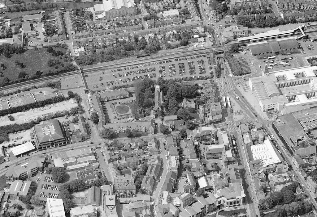
2 4.1 Transport Demand forecasting Arrival & departure models of people using oxford station For the purposes of this masterplanning work a time horizon of 2043 has been assumed for forecasts of future year usage of the station. Network Rail has provided the following emerging off-peak hourly service specification for the station: 3 Great Western trains at the station 3 Cross Country trains through the station 2 East West Rail trains through the station 2 Chiltern Railways trains terminating at the station from the north 3 freight trains through the station. Transport surveys were conducted at Oxford Station in 2008 to understand the transport modes used by Oxford Station passengers. The data collection shows that the majority of people accessing/departing from the station do so by foot. Below graphs provide summary from this data: AM Peak (08:00-09:00) Arrivals AM Peak (08:00-09:00) Departures Changes in passenger numbers are related to: Background growth of arrivals and departures from Oxford Station Growth associated with increased service provision for arrivals and departures Abstraction of trips to Oxford Parkway Station Rail interchanges trips. Forecasting work has been undertaken to inform the rail industry Long Term Planning Process, and for Oxfordshire County Council. From this it has been possible to create a number for forecast scenarios, as set out in Appendix 4. The demand forecasting indicates that the growth to 2043 will be 130%. A future scenario could also include Chiltern Railways operating 2tph through Oxford Station to serve Cowley and/or cross-city service utilising the Cowley Branch Line currently used for freight from BMW. Given the average forecast growth at Oxford Station and the increase in demand, for both passenger and freight traffic, investment is required to ensure this growth can be attained and unhindered by constraints of the current station. PM Peak (17:00-18:00) Arrivals PM Peak (17:00-18:00) Departures Peds Cyclists Bus (forecourt) Bus (other) Taxi Private car (drop off) Private car (Parking) Service Page 62
3 4.1 Transport Current modal provision and considerations Frideswide square Mode Current provision Considerations Pedestrians Access via station forecourt Pedestrian access through Frideswide Square is not intuitive/direct. Cyclists Car driver Access via entrance on Roger Dudman Way (peak times only) Provision for pedestrians under Botley Road is via a narrow enclosed walkway There are circa 600 (as of 2010) cycle stands, some of which are covered Cycle lockers and Brompton Docks are also provided There are a total of circa 531 car park spaces for passengers at the station (including circa 480 at the long stay car park on Becket Street. The long stay car park is well used at times (though not at capacity) Car drivers can use the long stay car park on Becket Street operated by Apcoa. Station entrance is not clearly visible for pedestrians Fully DDA compliant access is required as existing. Frideswide Square scheme will change pedestrian approach to the station. Development areas (Oxpens/ Westgate) will change pedestrian demand distribution Need for cycle storage on Roger Dudman Way Security/surveillance is to be considered Covered cycle storage is preferable Disabled bays are to be provided within 50 metres of the entrance(s) Potential for decking Becket Street car park Making Becket St two-way could remove some car parking spaces. Current wayfinding around the station area could be improved especially the legibility through Frideswide Square. The Oxford Station Masterplan provides an opportunity and platform to link all new developments and the city centre towards the focal point and main transport hub that provides the welcome point to the city for many residents and visitors alike. The proposal for Frideswide Square will allow traffic to move smoothly but slowly through the space which, coupled with the additional public space, will provide greater priority and freedom to pedestrians, cyclists and public transport users. This will change the pedestrian approach to the station from narrowly defined footpaths to numerous desire lines across the whole square. The redevelopment of the Westgate Centre and Oxpens will create new pedestrian movements from the south with a strong desire line entering Frideswide Square from Becket Street. A series of wayfinding points will be required to meet this new pedestrian demand. Car passenger (Kiss and Ride) Buses (within forecourt) Daily rate for the long stay car park is A footbridge over Botley Road links the Becket Street car park to the station forecourt 43 short stay parking spaces are available to the north of the station forecourt Kiss and Ride activity currently occurs in the station forecourt, long stay and short stay car parks. There are currently 6 bus stops (R1-R6) in the forecourt Bus layover activities take place at the forecourt. Bus replacement facilities at present use the forecourt interchange and provide additional pressure at peak times. Formal provision is required that minimises the need for vehicles to reverse Relocate long distance buses from Gloucester Green to Becket St. Consider additional bus services to northern areas of the City. Accommodate longer length buses than those which currently use the forecourt (up to 15m) Covered passenger facilities should be provided. Taxis There is currently space for 8 taxi bays in the forecourt (more is achieved when they double stack which is often the case) Better accommodate Bus replacement facilities. Covered passenger facilities are preferable Page 63
4 4.2 Pedestrian Movement & rail passengers Movement plans for the current station layout Access to the current station building is constrained, with pedestrian/vehicle conflicts occurring for many users of the station. Cyclists and car park users have the least conflicted route, being able to enter the station building by the southern entrance. Many bus passengers, taxi passengers and potentially some unauthorised drop off on the main forecourt all have to cross circulating vehicles to reach the eastern station door. Disabled parking spaces and short-stay parking users are able to use the footway round the northern and eastern side of the building to reach the entrance without conflict with other vehicles. Key Pavements Rail Passengers movement zone Potential cross over conflict between pedestrians, cyclists and vehicles Potential cross over conflict between pedestrians and cyclists. Pedestrian desire line Pedestrian and rail passenger movement diagram Page 64

5 4.3 Cyclists cyclists Cycling is central to the ethos of Oxford and due to the rich university history has a high percentage of residents and visitors who cycle. This is reflected in a large area of cycle parking at the station. First Great Western has undertaken a study to ascertain the volume of cycle users that use the parking area. There is a large expectation that the proportion of cycle users requiring parking compared to non-cyclists will grow due to the local policy to encourage cycle use above car use. There is a large network of cycle lanes around the city centre albeit immediately around the station, improvements can be made by extending or widening dedicated cycle ways. In particular the narrow cycle route along Botley Road is potentially unsafe and unpleasant and would greatly benefit from a dedicated and potentially elevated lane. An expanded cycle hire facility attached to the station would further encourage cycle use. The diagram opposite shows Oxford s dual cycle route network, with the main cycle routes highlighted in solid green line, and the quiet cycle routes in doted line. On the main cycle routes there are often cycle lanes or tracks but not always. The quiet cycle routes are on back streets or shared with pedestrians (who generally have priority). The current provision for cyclists varies on the approach to the station. On the immediate approaches to Frideswide Square on carriageway cycle lanes are provided and an off-carriageway dual-use path is provided for the length of Becket Street. Through Frideswide Square there is a mixture of on carriageway cycle lanes and bus lanes with ASLs at the junctions. A number of quiet/off-road paths link the station and the north of the city via Rewley Road and the canal tow path. There is a mixture of dual-use cycle path and bus lane along the Botley Road. Cyclists movement diagram Key Main Cycle routes Dedicated Cycle Lanes / Bus Lanes Off-road routes / Quiet Cycle routes Cycle Parking Page 65

6 4.4 Bus & Coach Movement & stops Buses Buses utilise the Transport Interchange directly outside of the station. This is convenient but the facility is inadequate because: Bus stops are limited to six bays and a larger number are required. The area is often congested Visually the clutter of bus connected street furniture and queuing buses do not provide the right image for the city for visitors and regular users. The crossover at the Transport Interchange entrance between buses and taxis with pedestrians is not as safe as it could be. Coaches Coaches in the city generally utilise the Gloucester Green Bus Station which is the Oxford terminus for long-distance coach services, including the very frequent services to London and route X5 to Cambridge. The station is too small to accommodate more than a few local bus services that also serve the rail station. Multi modal linking of services between buses, taxis, rail and coaches is hindered by the location of Gloucester Green services away from the station. Buses and coaches are often standard sized double deckers and these cannot travel under Botley Bridge as it is too low. This is a significant constraint. Page 66 Bus Stations: 1. Oxford Railway Station 2. Gloucester Green Bus Station Bus & coach movement diagram Key Bus Route Coach Route Bus Stop Transport Interchange
7 4.5 Replacement Coach, Taxi movement & PICK UP Replacement Coaches Replacement coaches are utilised if rail services are cancelled and passengers need to be redirected to the road network to complete their journeys. There is at present no dedicated Replacement Coach parking and when called upon coaches (that have been parked off site) double park within the existing Transport Interchange. This causes additional congestion. taxis Taxis pick up and drop off within the Transport Interchange directly outside of the station. There is 8 formal spaces. This is convenient but the facility is inadequate because: Taxis utilise bus bays and illegally park to gain a total of 24 spaces. The area is often congested Visually the clutter of queuing taxis does not provide the right image for the city for visitors and regular users. The crossover at the Transport Interchange entrance between buses and taxis with pedestrians is not as safe as it could be. Passenger public drop off There is short term parking behind the station to the north. There are 51 spaces including 8 dedicated disabled. This is generally adequate for present demand. Although located conveniently adjacent to the station its location can be hard to find to new users. Access to the short stay is via the front of the station and through the bus interchange. This causes disruption, confusion and safety issues with cross over with pedestrians. Key Taxi movement diagram Drop Off parking Taxi Rank Major Through Routes Restricted Access Roads Minor Roads Page 67
 and A420 meet, to Frideswide Square at the junction with the station. The road is designated the A420.")
8 4.6 car movement & parking Car Movement Botley Road is the main arterial road into Oxford from the west. It stretches from the Botley Interchange, where the Oxford Ring Road (A34) and A420 meet, to Frideswide Square at the junction with the station. The road is designated the A420. It becomes West Way at Botley Bridge over Seacourt Stream to the west. To the east past the station it becomes Park End Street. Botley Road is an important bus and commuter route to Oxford from Cumnor, and Seacourt Park and Ride is located near the junction with the A34. Eastbound, it has a bus lane from the ring road until just before Osney Island, at which point there is a set of bus advancement traffic lights. It has cycle lanes in both directions. The road passes under Botley Bridge and at this point further congestion occurs as the road dips down to gain head room (though not enough for standard double deckers). It is dark and dank under the bridge and in dire need of improvement to enhance the approach into the city centre. The improvement of Botley Road is a key element to the success of the redevelopment of this area. 480 spaces Car Parking Long term parking is off Becket Street. It is well located and it would seem not fully utilised. A study should be undertaken to ascertain usage. This car park has 480 spaces and is operated by Apcoa and is for railway commuters only. Becket Street Car Park provides a poor urban realm with a sea of parking, limited landscape and poor linkages to the station (access is required across the Botley Road pedestrian bridge which is convoluted and of poor design). Station car drop off/ short term parking is located behind the Transport Interchange directly to the side of the station. This area consists of 43 spaces, and 8 disabled spaces. Car movement diagram Key Rail Passengers Car Park long and short term parking Staff Car Park Controlled Parking Zone Major Through Routes Restricted Access Roads Minor Roads Page 68
9 5.0 option development

10 5.1 OPTION Development Strategic Options In response to the project Requirements and Analysis eight initial Strategic Options were developed. These were consulted upon and presented at: Presentations and discussion session with the West End Steering Group, held in June 2013 A series of Stakeholder Surgeries, including key Councillors, senior Council officers and representatives from key organisations (including the Train Operating Companies) also held in June 2013 The majority of the Options dealt with the issues of: The location of a new station The location and extent of improved Transport Interchange The eight options were assessed against the Mission Statement and Key Objectives by the Masterplan Working Group. A summary of the detailed evaluation is included at Appendix 1 Strategic Options. The options were: Option A: New track & island platform & enhanced Station. This was discounted due to lack of benefits. Option B: New & passive tracks with new Station & underpass. This was discounted due to lack of benefits. Option C: New & passive tracks with new Station on existing Station footprint & active bridge. This was discounted due to lack of benefits and issues of phasing. Option D: New & passive tracks with new Station in new key location. This provided some benefits but lacked great improvements to the Transport Interchange. Option E: New & passive tracks with new Station over Botley Road connecting to improved Transport Interchange on either side of Botley Road. This provided large benefits but English Heritage had concerns with regard to loss of view into the city from Botley Road approach. Option F: As above with additional platform expansion to north and south of Botley Road. Although this development was seen as good there are technical and operational issues that make this difficult and costly to achieve. Option G: As Option E but with the new station on Becket Street. This provided operational issues including extended travel distances to access the platforms. Option H: Station relocated to Oxpens Site. A separate assessment of this option was undertaken by the Masterplan Working Group and was published separately. The report demonstrated that relocation was not a cost effective solution and any benefits that could be provided by relocation could be achieved on the present site. Strategic Option A Strategic Option B Strategic Option C Strategic Option D Strategic Option E Strategic Option F Strategic Option G Strategic Option H Developed Option 1 Developed Option 2 Developed Option 2 Revised Developed Option 3 Page 70
11 5.2 options appraisal The Strategic Options were presented and discussed at the West End Steering Group and Stakeholder Surgeries. There were positive responses and the feedback was utilised to develop the Developed Options. Three typologies were chosen to be developed further encompassing the benefits of each of the Strategic Options and showing good comparative alternative solutions. These were called developed options. Developed Options The three Developed Options were: 1. Do Minimum - new Station (eastern Entrance only), enhanced Transport Interchange and Rail Enhancement Project 2. New Station (east and west Entrance), new Transport Interchange on present site and Rail Enhancement project 3. New Station (east and west Entrance), new Transport Interchange on Becket Street and Rail Enhancement project Each of the three options were developed further and presented at various Stakeholder events. Options were costed and financially appraised. Further detail of the options and their evaluation is at Appendix 2 Developed Options. Rail Enhancement Project The Masterplan Working Group has worked closely with Network Rail to establish the requirements set out in the Rail Enhancement Project. The requirements of EWR phase 1/ Bay platform extension and passive track allowance has been incorporated. Preferred Masterplan Proposal: Two freight tracks retained Four through platforms One Bay platform The incorporation of the Rail Enhancement Project ensures the Key Objective of meeting expected rail growth demand is met. Options were discussed of how best to incorporate passive track allowance and the effect on phasing. Options 2 and 3 allowed for the full incorporation of the works. Location of New Station The Strategic Options dealt with several potential locations for a potential replacement station. Proposed locations for a new station were: 1. On existing footprint - Early assessment discounted a rebuilt (on same footprint) station as this provided phasing issues and limited potential for new additional tracks. 2. Extended existing station - Early assessment discounted an extended station as this provided phasing issues and limited potential for new additional tracks. 3. Site of existing cycle storage area - this location provided a good flexible space to locate a new station building. The site is well placed to meet the Key Objective - it is in a high profile location, can improve wayfinding to and from the station, allows a link across the tracks to provide both east, west and south entrances, dovetail with planned work to improve Botley Road Bridge, allow a phased approach (albeit one that must consider the effect on the YHA early on in the project) and is the most economic solution considering ease of build. 4. New station built over the Botley Road Bridge - This solution provides many of the benefits of Site 3 option but met with some resistance from some stakeholders (English Heritage). Therefore there is a greater planning risk with this solution. There are some practical phasing issues that could mean greater disruption to Botley Road for longer. Funding for a new station would potentially need to be found at the same time as construction of the bridge improvements. 5. New station built on Becket Street - This solution provides many of the benefits of Site 3 option and in some ways would be easier to build early as it does not effect the YHA. However the intended track layout (Rail Enhancement Project) and constraints that exist to enable straight views along platforms and to minimise walking distances mean that this option was discounted as it would necessitate longer platform walk distances. It was concluded that building on the existing cycle store area would be favoured and has been included in all developed options. Location of New Transport Interchange The Key Objective to enable a multi-modal interchange has been central to the project. As the project progressed the exact requirements were finessed and developed to include a revised Brief. Parking requirements were agreed as shown in following table: MODE Existing Required Bus and Coach Replacement Coach 0 6 non dedicated Taxi Cycle MODE Existing Required Car Parking Short Term parking 43 plus 8 disabled 43 plus 8 disabled Long Term Parking Staff The Developed options considered improvement to the Transport Interchange in three ways: 1. Retention of existing Transport Interchange - this option came nowhere near meeting the Key Objective to facilitate a Transport Interchange. 2. Enhancement of Transport Interchange in existing location - this option enabled: Some very minor improvements to parking numbers for buses No improvement to taxi arrangements An improved solution of subterranean cycle parking A new MSCP on Becket Street Minor improvement to short term parking The overall objective to improve the facilities and urban realm was not met. 3. Moving and enhancement of the transport Interchange to Becket Street - this provided a greatly enhanced solution: A larger separate bus and coach facility away from the immediate entrance of the station Improvements to taxi arrangements An improved solution of subterranean cycle parking A new MSCP on Becket Street Improvements to short term parking The overall objective to improve the facilities and urban realm was met. This option provided improvements to safety for pedestrians navigating the station approach either from other forms of transport, on foot or passing through. New Transport Interchange on Becket Street (Option 3) was the preferred solution. Operational Buildings The redevelopment of the station, age and condition of existing accommodation, inclusion of new track and platforms will necessitate the need for replacement operational buildings. Each option considered Page 71
12 providing different solutions including new buildings and or re-use. The preferred solution will be led by the Key Objectives to ensure that an exemplary gateway is achieved, expected rail growth is achieved, wider regeneration is encouraged and the masterplan is deliverable. The overall location of operational building is not directly linked to these albeit the day to day operation of the station cannot be overtly compromised during construction or in the final solution. The preferred proposal will work with the phasing requirements of the masterplan and will ensure the overall quality of accommodation is enhanced. Option 1 was thought not to meet this criteria. Location of Cycle Facilities Cycle storage (racks and lockers), potential cycle hire and cycle maintenance is an important element to the success of the project. Options include: Secure manned cycle storage combined with maintenance and hire facilities - this is considered a large benefit and meet the Key Objective to enhance multi- modal facilities. At grade cycle parking - The present facilities work in this manner and provide an active cycle friendly image to the city. However an expected doubling of required cycles parking racks from circa 600 to 1200 could be unsightly if grouped in large blocks. The preferred masterplan proposal was to provide large secure cycle parking potentially partially underground alongside smaller pockets of cycle parking areas adjacent to key nodal points around the site. Botley Bridge and Road The Rail Enhancement Project includes an additional track to the west which in turn will require the bridge to be widened over Botley Road to accommodate. Some disruption to Botley Road is inevitable. To minimise the longevity of disruption and maximise cost effectiveness other engineering works associated with the bridge should be undertaken at the same time. These include: Widening of Botley Road to accommodate an additional city centre bound highway Widening of Botley Road to accommodate two full standard width cycles ways and pathways Widening of bridge to accommodate new potential passive track Upgrade and adaptation of flood alleviation pumping station Potential cycle facilities For this element of the project to meet Key Objectives, to be deliverable, flexible and represent good value all works should be enabled at the same time. The masterplan proposals incorporated in options 2 and 3 to undertake all engineering work concurrently was preferred. Commercial Development The redevelopment of the masterplan area will enable commercial development to be incorporated. This could include offices, hotel, retail, education, leisure, residential etc. A balance should be made between maximising the value of any commercial development and optimising the infrastructure and public realm requirements of the project. Opportunities exist as follows: Commercial development on Becket Street car park - This has potential and is desirable, however a balance is to be made with the need to fully relocate a Transport Interchange. The interchange will also need to be light and airy and provide a semi enclosed environment - not fully built upon. Development around the existing station Transport Interchange (which is to be moved) - This is desirable and many options exist for potential uses as the site is adjacent to the Saïd Business School and station entrance. The creation of quality public realm and a retail/ leisure offer is desirable and will maximise values and enhance revenue streams. Development around potential western entrance and Roger Dudman Way - This is desirable to increase footfall between the entrances and create a vibrant station. Development on the site of the Network Rail depot to the south west of the site - This provides small scale potential for student housing or similar. Development over the tracks and/ or station - This has been subject to a separate study (see later sections of this document). Detailed analysis has proven that development would need to greatly exceed the maximum height that can be built within the city centre by approximately four storeys to outweigh the inflated costs of building above rail infrastructure. There could also be phasing issues. Retail opportunities within the station - This should be maximised to enhance potential revenue streams and create a vibrant development proposal. Both options 2 and 3 maximised development around the station and Transport Interchange whilst ensuring development is realistic, flexible and deliverable. Option 2 focussed commercial development on Becket street and Option 3 around the station. option evaluation The options were assessed against the Mission Statement and Key Objectives by the Masterplan Working Group. The assessment is summarised in the graph below. The three options were presented to the City and County Council members in November Subsequent to some refinement the three options and their assessment were presented to the Oxford Station Project Board. The Board consists of DfT, Oxford City Council, Oxfordshire County Council, Network Rail, FGW and LCR Objective 1 Exemplary Gateway Objective 2 Ops, growth & passengers Objective 3 Regen Catalyst Objective 4 Deliverability VFM Option Option Option Option 1 Option 2 Option 3 Option 1 was discounted as it does not meet many or any of the Key Objectives. Option 2 went some way in meeting all the Key Objectives but it was considered that it fell short in all areas. Importantly Option 2 proposed only an enhanced Transport Interchange on its existing site and this was considered not to provide enough benefit when compared to option 3. Option 3 met all Key Objectives and notably construction costs were similar to Option 2 and potential development value was marginally higher. Importantly Option 3 proposes a new Transport Interchange on Becket Street which was considered key to the success of the option. Therefore Option 3 was ratified by the Oxford Station Project Board as the Preferred Option.
IAN WHITE ASSOCIATES. Crawley Station Gateway Public Realm
 IAN WHITE ASSOCIATES Crawley Station Gateway Public Realm contents 1. objectives & client brief 2. site appraisal 3. best practice guidance 4. design concept 1. objectives & client brief Crawley Train
E4 Cycle Route Exeter University to Redhayes Bridge. - Recommendations from Exeter Cycling Campaign
 E4 Cycle Route Exeter University to Redhayes Bridge - Recommendations from Exeter Cycling Campaign 1.0 Introduction Exeter Cycling Campaign has prepared this report to provide recommendations for Devon
ABERDEEN: CITY OF THE FUTURE
 ABERDEEN: CITY OF THE FUTURE A contribution towards discussions on a future transport strategy for Aberdeen and its Region Prepared by the Centre for Transport Research University of Aberdeen June 2010
A127/A130 Fairglen Interchange Improvement Schemes. Information Leaflet February 2017
 A127/A130 Fairglen Interchange Improvement Schemes Information Leaflet February 2017 1 2 Foreword By Councillor Kevin Bentley Essex is continuing to grow as a vibrant economic hub and as a fantastic place
Tel: Karime Hassan Chief Executive Exeter City Council Civic Centre Paris Street Exeter EX1 1JN
 Page 1 of 6 Karime Hassan Chief Executive Exeter City Council Civic Centre Paris Street Exeter EX1 1JN Dear Mr Hassan 14th September 2015 Re: Development of Bus & Coach Station Site Following the submission
Cabinet Member for Highways & Streetscene. Highway Infrastructure Manager
 LONDON BOROUGH OF RICHMOND UPON THAMES DATE: AUGUST 2015 DECISION MAKER: LEAD OFFICER: SUBJECT: WARDS: Cabinet Member for Highways & Streetscene Highway Infrastructure Manager PROPOSED CYCLING IMPROVEMENTS
Your views are important. Please fill in a form before you leave. Or alternatively
 Drum Property Group is delighted to welcome you to this exhibition which sets out our initial proposals for a mixed-use development at Stead s Place, Edinburgh. We are keen to hear the views of local people
LEA BRIDGE ROAD - A STREET FOR EVERYONE Public consultation document
 LEA BRIDGE ROAD - A STREET FOR EVERYONE Public consultation document TELL US Bakers Arms to Leyton Green Road (Section D, E, F) Leyton Green Road to Whipps Cross Roundabout (Section G) YOUR VIEWS www.enjoywalthamforest.co.uk
Appendix N(b): Portishead Station Outline Travel Plan
: Portishead Station Outline Travel Plan") Portishead Branch Lane (MetroWest Phase 1): Environment Impact Assessment Appendix N(b): Portishead Station Outline Travel Plan Prepared for West of England Councils September 2017 1 The Square Temple
Portishead Branch Lane (MetroWest Phase 1): Environment Impact Assessment Appendix N(b): Portishead Station Outline Travel Plan Prepared for West of England Councils September 2017 1 The Square Temple
Design Workshops Summary of all Feedback January 2017
 Histon Road Corridor Design Workshops Summary of all Feedback January 2017 CITY DEAL AND GROWTH Commitment to Growth: Government, County, City and District Emerging Local Plans: 33,000 new homes 45,000
Technical note. 1. Introduction
 Project: A428 study - Phase 2 To: Adrian Shepherd Subject: Park & Ride site locations From: Atkins Date: Jun 3, 2016 cc: Ashley Heller 1. Introduction 1.1. Purpose of Technical Note The purpose of this
TRANSPORT AND MOVEMENT
 TRANSPORT AND MOVEMENT Movement Strategy Public Transport Cycling and Walking Road Network Parking Standards Transport Impact Assessments Traffic Management Policies DRAFT POOLBEG PLANNING SCHEME Movement
1.5 On this basis it is fundamental that the Transport Strategy for the site focuses on the following key criteria,
 1.0 Introduction 1.1 The Transport Assessment has been prepared on behalf of Eon and Roger Bullivant Ltd in respect of the proposed mixed use sustainable urban extension of Drakelow Park. 1.2 The methodology
ENFIELD TOWN THE REVISED DESIGN
 TOWN THE REVISED DESIGN We re turning Enfield into a borough that encourages walking and cycling, a place that s easy for all of us to get around however we choose to travel. A greener place, with safer
Nottingham Cycle City Frequently Asked Questions
 Nottingham Cycle City Frequently Asked Questions About the scheme How much money is to be spent on cycling? And where is the money from? We have 6.1 million in Growth Fund which we will be investing directly
Douglas Land Use and Transportation Strategy (DLUTS) Summary. August 2013
 Summary. August 2013") Douglas Land Use and Transportation Strategy (DLUTS) Summary August 2013 Background Douglas is a large and popular residential suburb of approximately 30,000 persons on the periphery of Cork City along
Douglas Land Use and Transportation Strategy (DLUTS) Summary August 2013 Background Douglas is a large and popular residential suburb of approximately 30,000 persons on the periphery of Cork City along
March Maidstone Integrated Transport Strategy Boxley Parish Council Briefing Note. Context. Author: Parish Clerk 2 March 2016
 Context. Author: Parish Clerk 2 The Draft Integrated Transport Policy (DITS) sets out a vision and objectives, and identifies a detailed programme of interventions to support the Maidstone Borough Local
Appendix 12 Parking on footways and verges
 Appendix 12 Parking on footways and verges Legal position Parking on footways and verges whether wholly or partly is banned throughout London, unless signs are placed to allow parking. The ban requires
HISTON ROAD Have your say on better public transport, cycling and walking journeys
 HISTON ROAD Have your say on better public transport, cycling and walking journeys Have your say: Please complete the survey inside this leaflet or online at www.greatercambridge.org.uk/histonconsultation
21.07 TRANSPORT CONNECTIVITY AND INFRASTRUCTURE
 21.07 TRANSPORT CONNECTIVITY AND INFRASTRUCTURE 21.07-1 Connectivity and Choice Transport connectivity and mode choice are critical to achieving productive, sustainable and socially just cities. Travel
Strategy for Walking & Cycling Action Plan
 Strategy for Walking & Cycling Action Plan To achieve higher levels of walking and cycling activity, the destinations which people access have to be available within suitable distances and designed to
Chelmsford City Growth Package
 Chelmsford City Growth Package Public Consultation Document Volume 2 West Chelmsford July - August 2017 Chelmsford City Growth Package Public Consultation Document - Volume 2 - West Chelmsford Contents
High frequency bus services operating to Little Island; Creation of a new Park and Ride site and train station at North Esk;
 Cork County Council 7 th December 2018 Dear Adrian O Neill (aoneill@jbbarry.ie) The Transport and Mobility Forum, Cork (TMF) is a representative group of organisations who have a common interest in sustainable
REF. PE01595: MORATORIUM ON SHARED SPACE SCHEMES
 PE1595/RRR Sustrans submission of 17 March 2017 Following the Public Petitions Committee meeting on 9 th February 2017 you wrote to Sustrans Scotland requesting a clarification on our position on the use
SCHEME DESIGN AND ENGINEERING
 THE NORTH SOMERSET COUNCIL (SOUTH BRISTOL LINK CLASSIFIED ROAD) SIDE ROADS ORDER 2013 THE NORTH SOMERSET COUNCIL (SOUTH BRISTOL LINK) COMPULSORY PURCHASE ORDER 2013 THE NORTH SOMERSET COUNCIL (SOUTH BRISTOL
DESIGN CODE. Enterprise West Harlow London Road North Design Code 21
 DESIGN CODE Enterprise West Essex @ Harlow London Road North Design Code 21 4 MAXIMUM BUILDING HEIGHTS 4.1 Table 4A sets out maximum building height standards for each character area within the LDO boundary.
Joint Response to the Department for Transport Consultation on the Station Champions Report on Better Rail Stations. February 2010
 Joint Response to the Department for Transport Consultation on the Station Champions Report on Better Rail Stations Joint Response to the Better Rail Stations Consultation This response has been prepared
Map 1 shows the two roads, and how they fit into the public transport network in and around Cambridge.
 Milton Road and Histon Road corridors bus priority infrastructure 1. Purpose The County Council would like to understand in more detail, the options to deliver the most effective corridor-based public
Exhibit 1 PLANNING COMMISSION AGENDA ITEM
 Exhibit 1 PLANNING COMMISSION AGENDA ITEM Project Name: Grand Junction Circulation Plan Grand Junction Complete Streets Policy Applicant: City of Grand Junction Representative: David Thornton Address:
Bulwell Cycling Consultation
 Bulwell Cycling Consultation Image 1 Bulwell Bogs (Sutton, 2015) As part of a final year research project, I am seeking feedback on proposals for cycling improvements in Bulwell. This consultation is not
The Cabinet Member for Highways & Streetscene. Aurang Zeb - Head of Highways & Transport
 LONDON BOROUGH OF RICHMOND UPON THAMES Cabinet Member Decision DATE: January 2012 REPORT OF: LEAD OFFICER: SUBJECT: WARDS: The Cabinet Member for Highways & Streetscene Aurang Zeb - Head of Highways &
BYRES ROAD: PUBLIC REALM Public Consultation
 Public Consultation Introduction As a vibrant commercial, shopping and residential location within the heart of the West End Byres Road is an important destination. Its proximity to the University of Glasgow
MILTON ROAD LLF PROJECT UPDATE
 Greater Cambridge City Deal MILTON ROAD LLF PROJECT UPDATE 9 th May 2017 Project objectives Comprehensive priority for buses in both directions wherever practicable; Additional capacity for sustainable
WELCOME. Purpose of the Open House. Update you on the project. Present a draft recommended plan. Receive your input
 WELCOME Purpose of the Open House The Town of Smiths Falls has initiated the Beckwith Street Redevelopment Plan that includes the preparation of a streetscape functional design for the renewal of Beckwith
North West Non-Technical Summary of the Transport Assessment September 2011
 North West Non-Technical Summary of the Transport Assessment September 2011 Introduction This is a Non-Technical Summary of the findings of the Transport assessment work undertaken for the proposed North
TRAVEL PLAN: CENTRAL EUROPEAN UNIVERSITY CAMPUS REDEVELOPMENT PROJECT TRAVEL PLAN. Central European University Campus Redevelopment Project.
 TRAVEL PLAN Central European University Campus Redevelopment Project Page 1 Table of Contents Introduction... 3 Background... 7 Building Users... 7 Transportation in Community Consultation... 7 Summary
ONE SIZE DOESN T FIT ALL RECONCILING OVERLAPPING TRANSPORT NETWORKS IN A CONSTRAINED URBAN ENVIRONMENT
 One Size Doesn t Fit All S Corbett, C Chenery Page 1 ONE SIZE DOESN T FIT ALL RECONCILING OVERLAPPING TRANSPORT NETWORKS IN A CONSTRAINED URBAN ENVIRONMENT Authors/Presenters: Sam Corbett, Principal Transport
The Wincheap Society
 The Wincheap Society s on sections of: Thanington 4th Arm Slip Road, Walking, Cycling & Horse-Riding Assessment & Review Report, by Peter Brett Associates, October 2017, on behalf of Pentland Properties
2. Context. Existing framework. The context. The challenge. Transport Strategy
 Transport Strategy Providing quality connections Contents 1. Introduction 2. Context 3. Long-term direction 4. Three-year priorities 5. Strategy tree Wellington City Council July 2006 1. Introduction Wellington
Report to Cabinet. 18 May 2016
 Agenda Item 8 Report to Cabinet 18 May 2016 Subject: Presenting Cabinet Member: Proposed CCTV Enforcement of Traffic Contraventions in a Bus Lane (Key Decision Ref. No. HE030) Highways and Environment
UNDERSTANDING WALKING NETWORKS TO ENABLE SMARTER CHOICES IN TRANSPORT PLANNING IN DUNDEE. Gillian Iversen Atkins
 UNDERSTANDING WALKING NETWORKS TO ENABLE SMARTER CHOICES IN TRANSPORT PLANNING IN DUNDEE Gillian Iversen Atkins 1. INTRODUCTION 1.1. Smarter Choices, Smarter Places The Smarter Choices agenda encourages
Frascati Road and Temple Hill Route Improvements. Outline Design Report to Accompany Public consultation
 Frascati Road and Temple Hill Route Improvements Outline Design Report to Accompany Public consultation September 2013 Background: Dún Laoghaire-Rathdown is committed to providing high quality pedestrian
Transportation Master Plan Advisory Task Force
 Transportation Master Plan Advisory Task Force Network Alternatives & Phasing Strategy February 2016 BACKGROUND Table of Contents BACKGROUND Purpose & Introduction 2 Linking the TMP to Key Council Approved
APPENDIX 2 LAKESHORE ROAD TRANSPORTATION REVIEW STUDY EXECUTIVE SUMMARY
 APPENDIX 2 LAKESHORE ROAD TRANSPORTATION REVIEW STUDY EXECUTIVE SUMMARY Appendix 2 City of Mississauga Lakeshore Road FINAL REPORT Transportation Review Study December 2010 EXECUTIVE SUMMARY Study Purpose
The existing site constraints which may be encountered for the A428 scheme proposals are divided into sections as follows.
 Project: A428 Study To: Cambridgeshire County Council Subject: Tidal Bus lane Review From: Atkins Date: 24 May 2016 cc: Introduction As part of the A428 Corridor Study to improve the bus journey time between
9. Parking Supporting Statement
 9. Parking Supporting Statement Content 1. Setting the Scene 2. Vision 3. Parking and the Shared Priorities 4. Issues 5. Delivery Programme in the first Plan Period 2001/02 2005/06 6. Good Practice 7.
Walking and Cycling Action Plan Summary. A Catalyst for Change The Regional Transport Strategy for the west of Scotland
 Walking and Cycling Action Plan Summary A Catalyst for Change The Regional Transport Strategy for the west of Scotland 2007-2021 Strathclyde Partnership for Transport Contents Purpose...2 Issues, Constraints
Berwick Health and Education Precinct: Casey Amendment C207 (Part 1) Submission to Planning Panels Victoria
 Submission to Planning Panels Victoria") Berwick Health and Education Precinct: Casey Amendment C207 (Part 1) Submission to Planning Panels Victoria August 2018 CONTENTS 1 Executive summary... 1 2 Summary of the amendment... 2 3 Submission...
Berwick Health and Education Precinct: Casey Amendment C207 (Part 1) Submission to Planning Panels Victoria August 2018 CONTENTS 1 Executive summary... 1 2 Summary of the amendment... 2 3 Submission...
Chapter 7. Transportation. Transportation Road Network Plan Transit Cyclists Pedestrians Multi-Use and Equestrian Trails
 Chapter 7 Transportation Transportation Road Network Plan Transit Cyclists Pedestrians Multi-Use and Equestrian Trails 7.1 TRANSPORTATION BACKGROUND The District of Maple Ridge faces a number of unique
National Transport Awards Cambridge Park & Ride
 National Transport Awards Cambridge Park & Ride What Cambridgeshire has achieved q An award winning scheme focussed on quality. q Four sites, with a fifth site due to be built later this year. q 950,000
WEST AND SOUTH WEST RING ROAD DOWNSTREAM TRAFFIC IMPACTS
 Page 1 of 9 EXECUTIVE SUMMARY Alberta Transportation ( AT ) is preparing to construct the final sections of the Calgary Ring Road. This includes the South West Ring Road ( SWRR ) (from Lott Creek Blvd
CUERDEN TRANSPORT PROPOSALS
 1 CUERDEN TRANSPORT PROPOSALS The transport assessment, submitted with the Cuerden development planning application, looks at access to the site and the impact on the local road network in detail. This
BELFAST RAPID TRANSIT. Ciarán de Búrca Director, Transport Projects Division Department for Regional Development
 BELFAST RAPID TRANSIT Ciarán de Búrca Director, Transport Projects Division Department for Regional Development Objectives of Belfast Rapid Transit To provide a modern, safe, efficient and high quality
University of Victoria Campus Cycling Plan Terms of Reference. 1.0 Project Description
 University of Victoria Campus Cycling Plan Terms of Reference 1.0 Project Description The Campus Cycling Plan, a first for the University, will provide a comprehensive and coordinated approach to support
Part 3: Active travel and public transport planning in new housing developments
 1 Linking active travel and public transport to housing growth and planning Part 3: Active travel and public transport planning in new housing developments Active Travel Toolkit Slide Pack July 2017 Linking
C.A.R.S. Project Design Report.
 C.A.R.S. Project Design Report. PRODUCED BY: Browne, A. Kennedy, M. Dolan, N. Selman, C. STUDENT NO: DATE DUE: COURSE: LECTURER: C09365788-C09686908-D11125480-C08868352 20-April-2012 Dt004/3 Civil Engineering
Update June 2018 OUR 2017 PUBLIC ENGAGEMENT
 Update June 2018 Hi, Let s Get Wellington Moving (LGWM) is developing a Recommended Programme of Investment (RPI) that meets our programme objectives and supports the city s and region s growth. As part
Phone: Ref No: 06/2018/0884
 Development Directorate Preston City Council Town Hall Lancaster Road Preston PR1 2RL FAO Ben Sandover Phone: 01772 533855 Email: david.allen@lancashire.gov.uk Ref No: 06/2018/0884 Date: 20 September 2018
A7 Transportation and Access: Application 2 - LBHF
 A7 Transportation and Access: Application 2 - LBHF Addendum to the Environmental Statement Volume I January 2012 Introduction A7.1 This Chapter of the Addendum to the June 2011 Environmental Statement
Progress update on the Sustainable Movement Corridor scheme Guildford Borough Council, June 2016
 Progress update on the Sustainable Movement Corridor scheme Guildford Borough Council, June 2016 1. Introduction The concept of the Sustainable Movement Corridor (hereafter the SMC ) was first developed
Mumford Terminal Replacement Opportunities Neighbourhood Open House. we are here. PHASE 2 Identifying and Evaluating Candidate Sites
 Welcome Replacement Opportunities Neighbourhood Open House. AGENDA PURPOSE 1. REVIEW the information boards 2. DISCUSS aspects of the project with the project team 3. SHARE your thoughts on replacement
RAA Submission to: The City of Adelaide Draft Integrated Movement Strategy Moving Adelaide
 RAA Submission to: The City of Adelaide Draft Integrated Movement Strategy 2012-22 Moving Adelaide May 2012 RAA Submission to the City of Adelaide Draft Integrated Movement Strategy 2012-22 Moving Adelaide
Guildford Borough (Draft)
") ITEM Annex Page 7 Guildford Borough (Draft) Forward Programme Part A This is a work in progress and its completion is subject to the adoption of the Local Plan and Infrastructure Delivery Schedule November
ITEM Annex Page 7 Guildford Borough (Draft) Forward Programme Part A This is a work in progress and its completion is subject to the adoption of the Local Plan and Infrastructure Delivery Schedule November
City of Perth Cycle Plan 2029
 Bicycling Western Australia s response City of Perth Cycle Plan 2029 2012-2021 More People Cycling More Often ABOUT BICYCLING WESTERN AUSTRALIA Bicycling Western Australia is a community based, not-for-profit
A1307 Haverhill to Cambridge: Approval to consult on transport improvement concepts
 Report To: Greater Cambridge City Deal Executive Board 3 March 2016 Lead Officer: Graham Hughes, Executive Director of Economy, Transport and Environment, Cambridgeshire County Council A1307 Haverhill
M6 Junction 10 Public Consultation
 M6 Junction 10 Public Consultation December 2015 Introduction Walsall Council and Highways England are developing plans to provide a long term improvement to M6 junction 10. We are holding this non-statutory
Transit boulevard: A new road type for Sydney s Growth Centres
 Transit boulevard: A new road type for Sydney s Growth Centres Cleaver, M. A., de Roos, M. P., NSW Centre for Road Safety, Roads and Traffic Authority, NSW Collins, G., Network Services, Roads and Traffic
TRANSPORTATION NEEDS ASSESSMENT
 TRANSPORTATION NEEDS ASSESSMENT A travel demand analysis was carried out to determine the operational issues and the potential benefit that adding traffic capacity would have on the road network. All the
Rhebogue Neighbourhood Greenway. Road Safety Audit Stage 2
 Rhebogue Neighbourhood Greenway Road Safety Audit Stage 2 Report Number: 12/007/00/00057 July 2014 Mid West National Road Design Office Lissanalta House, Dooradoyle County Limerick Tel: 061 496 800 Fax:
EXECUTIVE SUMMARY Callan Park accommodates travel from a wide range of transport modes, including walking, cycling, bus and light rail.
 TRANSPORT AND ACCESS EXECUTIVE SUMMARY Callan Park accommodates travel from a wide range of transport modes, including walking, cycling, bus and light rail. Whilst there are some walking facilities within
4. Guided Bus Explained
 4. Guided Bus Explained Contents 1 INTRODUCTION... 2 Structure of this report... 2 2 KERB GUIDED BUS... 3 Overview... 3 Kerb guidance... 3 Figures Figure 2.1 Figure 2.2 Figure 2.3 Figure 2.4 Figure 2.5
University of Leeds Travel Plan
 University of Leeds Travel Plan 2015-2018 Contents 1: Introduction 1.1 What is a Travel Plan? 1.2 Why do we need one? 1.3 Sustainability Strategy 2: Overview 2.1 The bigger picture 2.2 The City scale 2.3
122 Avenue: 107 Street to Fort Road
 : 107 Street to Fort Road November 24, 2015 4:30 8:00 p.m. Meeting Purpose Summarize project work completed to date Share results of public input from Phase 1 Share the draft concept plan and proposed
Community engagement guide May 2018
 Community engagement guide May 2018 Greater Wellington Regional Council (GWRC), Hutt City Council (HCC) and the New Zealand Transport Agency (NZTA) are working together to achieve some big improvements
Maynooth Cycling Submission on North South Corridor
 Maynooth Cycling Submission on North South Corridor Maynooth Cycling welcomes the intention to improve facilities and quality of service for pedestrians and cyclists in Maynooth. In particular, we strongly
Derby Cycling Group, c/o 126, Station road, Mickleover, Derby, DE3 9FN. Date: 20 th November, 2018.
 Your Ref: Derby City Council Air Quality - Preferred Option Nov 2018 Derby Cycling Group, c/o 126, Station road, Mickleover, Derby, DE3 9FN Date: 20 th November, 2018. 1. Introduction: 1.1. Derby Cycling
Comments on the Hailsham to Eastbourne Sustainable Transport Corridor
 Comments on the Hailsham to Eastbourne Sustainable Transport Corridor Version 1.1 25/01/2015 Paul Humphreys 1 Table of Contents Version Control... 2 Summary... 2 Rationale provided by ESCC... 3 The ESCC
CAMBRIDGE SOUTH WEST PARK & RIDE
 CAMBRIDGE SOUTH WEST PARK & RIDE Have your say on: Extra Park & Ride spaces to the south west of Cambridge Bus priority measures into the city centre CREATING MORE PARK & RIDE SPACES The existing Park
WELCOME TO OPEN HOUSE # 1 June 14, 2017
 Langstaff Road Weston Road to Highway 7 Class Environmental Assessment Study WELCOME TO OPEN HOUSE # 1 June 14, 2017 Please sign in and join our mailing list Purpose of Open House #1 & Study Area York
1 This technical note considers the issues associated with the use of tidal flow bus lanes on key public transport corridors in Cambridge.
 TECHNICAL NOTE: TIDAL FLOW BUS LANE OPTION ASSESSMENT Purpose 1 This technical note considers the issues associated with the use of tidal flow bus lanes on key public transport corridors in Cambridge.
MANNERS/DIXON/VICTORIA/WlLLlS STREETS TRAFFIC AND STREETSCAPE IMPROVEMENTS
 I! ATTACHMENT 3 TO REPORT 03.481 PAGE 1 OF 13 CITY INFRASTRUCTURE COMMllTEE 6 AUGUST 2003 MANNERS/DIXON/VICTORIA/WlLLlS STREETS TRAFFIC AND STREETSCAPE IMPROVEMENTS REPORT 4 (I 215/48/IM) 1. Purpose of
DYNAMIC LANES FOR AUCKLAND
 Dynamic Lanes for Auckland MENEZES M. and INMAN R. Page 1 DYNAMIC LANES FOR AUCKLAND Authors: INMAN, Robert BA (Hons) Previously Auckland Transport Senior Traffic Engineer Now Aurecon Robert.Inman@aurecongroup.com
Bus and Transit Lane Review Update
 Board Meeting / 25 February 2013 Agenda Item no.8(i) Bus and Transit Lane Review Update Glossary Auckland Transport New Zealand Transport Agency Transit Two Transit Three (AT) (NZTA) (T2) (T3) Executive
Hopkins Architects. University of Nottingham. University Park Campus Masterplan Strategy. 13 th February 2009
 University of Nottingham University Park Campus Masterplan Strategy 13 th February 2009 Purpose of this Document The purpose of this document is to set out a new masterplan strategy for University Park
London Cycle Network Annual Report 2000
 London Cycle Network Annual Report 2000 A cycle network for London by 2005 A cycle network for London by 2005 The London Cycle Network will: provide local links between residential neighbourhoods, railway
Tonight is for you. Learn everything you can. Share all your ideas.
 Strathcona Neighbourhood Renewal Draft Concept Design Tonight is for you. Learn everything you can. Share all your ideas. What is Neighbourhood Renewal? Creating a design with you for your neighbourhood.
Introduction. Prince Street Cycling Ambition Fund Public Realm Project
 Introduction The (CAF) project will create a high quality, 8-80 s cycle route up the west side of Prince Street from Cumberland Road, over Prince Street bridge to the Centre. This is part of the City Centre
Lea Bridge Road A street for everyone Tell us
 Lea Bridge Road A street for everyone Tell us Public consultation document Section H your views 1 Lea Bridge Road: a street for everyone Introduction Mni-Holland is an exciting programme to improve walking
CHURCH ROAD. Public consultation document TELL US YOUR VIEWS.
 CHURCH ROAD Public consultation document YOUR TELL US VIEWS www.enjoywalthamforest.co.uk CHURCH ROAD Introduction Waltham Forest Council was one of three boroughs to be awarded 27million of funding from
Guide to the Cycle Enfield Public Consultation on Enfield Town. Produced by the Save Our Enfield Town Campaign Group
 Guide to the Cycle Enfield Public Consultation on Enfield Town Produced by the Save Our Enfield Town Campaign Group What s in this guide? Introduction Page 3 What Enfield Council says about Option 1 Page
Oxfordshire Local Transport Plan 4 Science Vale Cycle Network Project Proposal Didcot Ladygrove Link
 Overview of project: The Ladygrove Link will provide a modern, direct, off-road, active travel route from the new Didcot North East development and new leisure centre to the strategic Cow Lane Tunnel.
Kings Road, Herne Bay: Proposed Crash Remedial Measure
 Kings Road, Herne Bay: Proposed Crash Remedial Measure To: Canterbury Joint Transportation Board 17 February 2015 By: Classification: Ward: Tim Read - Head of Transportation Unrestricted Herne Bay Summary:
Living Streets response to the Draft London Plan
 Living Streets response to the Draft London Plan Contents Living Streets response to the Draft London Plan... 1 About Living Streets... 2 Summary... 2 Consultation response... 3 Chapter 1: Planning London
Temple Circus Consultation. Consultation Capture Report
 Temple Circus Consultation Consultation Capture Report February 2017 Contents Introduction... 2 Background to the scheme... 2 Wider context... 2 Methodology... 4 Consultation materials... 4 Leaflet...
Public Consultation on Braintree Integrated Transport Package (ITP) HAVE YOUR. Consultation open from 24 September to 5 November 2018 SAY
 HAVE YOUR. Consultation open from 24 September to 5 November 2018 SAY") Public Consultation on Braintree Integrated Transport Package (ITP) HAVE YOUR SAY Consultation open from 24 September to 5 November 2018 Contents Introduction 3 Background 4 Springwood Drive Roundabout
Public Consultation on Braintree Integrated Transport Package (ITP) HAVE YOUR SAY Consultation open from 24 September to 5 November 2018 Contents Introduction 3 Background 4 Springwood Drive Roundabout
TGSI Tactile Ground Surface Indicators
 TGSI Tactile Ground Surface Indicators Introduction: This Design Note, No 11, provides guidelines and requirements for the use and installation of Tactile Ground Surface Indicators (TGSI s). References
Frome Street Bicycle Route
 The Adelaide City Council invites engagement from the community about Frome Street Bicycle Route Project Summary Adelaide City Council is seeking feedback on design options to construct bicycle facilities
CHECKLIST 2: PRELIMINARY DESIGN STAGE AUDIT
 CHECKLIST 2: PRELIMINARY DESIGN STAGE AUDIT 2.1 General topics 2.1.1 Changes since previous audit Do the conditions for which the scheme was originally designed still apply? (for example, no changes to
Background. Caversham a vision for the future. Joint public meeting arranged by:
 Joint public meeting arranged by: Sharing our Streets Caversham a vision for the future and Caversham Traders Association This presentation followed a presentation by Simon Beasley, Network Manager for
Welcome. Background. Goals. Vision
 Welcome The formal Public Information Centre (PIC) for the Transportation Master Plan How We GO will be held in early 2017. At that time we will present the recommended transportation system for Niagara