TRAFFIC IMPACT STUDY COMPREHENSIVE UPDATE TOWN OF THOMPSON S STATION, TENNESSEE PREPARED FOR: THE TOWN OF THOMPSON S STATION
|
|
|
- Clifford King
- 6 years ago
- Views:
Transcription

1 TRAFFIC IMPACT STUDY COMPREHENSIVE UPDATE TOWN OF THOMPSON S STATION, TENNESSEE PREPARED FOR: THE TOWN OF THOMPSON S STATION Transportation Consultants, LLC TH AVENUE SOUTH NASHVILLE, TN SEPTEMBER 2015
2 TRAFFIC IMPACT STUDY COMPREHENSIVE UPDATE TOWN OF THOMPSON S STATION, TENNESSEE PREPARED FOR: THE TOWN OF THOMPSON S STATION PREPARED BY: RPM TRANSPORTATION CONSULTANTS, LLC th Avenue South Nashville, TN office fax
3 TABLE OF CONTENTS 1. INTRODUCTION Study Purpose and Need Methodology EXISTING CONDITIONS Existing Roadway Network Regional and Local Access Existing Traffic Volumes Existing Traffic Operations IMPACTS AND TRAFFIC OPERATIONS IN Establishing Background Traffic Volumes Trip Generation Trip Distribution and Traffic Assignment Projected Traffic Operations in CONCLUSIONS AND RECOMMENDATIONS STUDY ADDENDUM...41 APPENDICES... 42
4 LIST OF FIGURES FIGURE 1. LOCATION OF THE PROJECT SITE 4 FIGURE 2. EXISTING LANEAGE...6 FIGURE 3. EXISTING PEAK HOUR TRAFFIC VOLUMES 8 FIGURE 4. BACKGROUND PEAK HOUR TRAFFIC VOLUMES 15 FIGURE 5. ESTIMATED DAILY TRIPS TO BE GENERATED BY FUTURE PLANNED DEVELOPMENT...19 FIGURE 6. PROJECTED PEAK HOUR TRAFFIC VOLUMES 21 FIGURE 7. RECOMMENDED IMPROVEMENTS: COLUMBIA PIKE AND CRITZ LANE...31 FIGURE 8. RECOMMENDED IMPROVEMENTS: COLUMBIA PIKE AND THOMPSON STATION ROAD...32 FIGURE 9. RECOMMENDED IMPROVEMENTS: LEWISBURG PIKE AND CRITZ LANE..33 FIGURE 10. RECOMMENDED IMPROVEMENTS: THOMPSON S STATION ROAD AND BUCKNER LANE 34 FIGURE 11. RECOMMENDED IMPROVEMENTS: LEWISBURG PIKE AND WESTBOUND STATE ROUTE 840 ON/OFF RAMPS..35 FIGURE 12. RECOMMENDED IMPROVEMENTS: LEWISBURG PIKE AND EASTBOUND STATE ROUTE 840 ON/OFF RAMPS 36 FIGURE 13. RECOMMENDED IMPROVEMENTS: LEWISBURG PIKE AND THOMPSON S STATION ROAD 37 FIGURE 14. RECOMMENDED IMPROVEMENTS: THOMPSON S STATION ROAD AND PANTALL ROAD 38 FIGURE 15. RECOMMENDED IMPROVEMENTS: CRITZ LANE AND CLAYTON ARNOLD ROAD 39 FIGURE 16. RECOMMENDED IMPROVEMENTS: CRITZ LANE AND PANTALL ROAD.40
5 LIST OF TABLES TABLE 1: EXISTING FEATURES OF STUDY AREA ROADWAYS... 5 TABLE 2: DESCRIPTIONS OF LEVEL OF SERVICE FOR UNSIGNALIZED INTERSECTIONS... 9 TABLE 3: DESCRIPTIONS OF LEVEL OF SERVICE FOR SIGNALIZED INTERSECTIONS TABLE 4: EXISTING PEAK HOUR LEVELS OF SERVICE TABLE 5: SPECIFIC PROJECTS USED FOR DEVELOPMENT-GENERATED TRAFFIC ESTIMATES TABLE 6: PEAK HOUR LEVELS OF SERVICE 2020 PROJECTED CONDITIONS TABLE 7: PEAK HOUR LEVELS OF SERVICE 2020 PROJECTED CONDITIONS WITH RECOMMENDED IMPROVEMENTS... 26
6 1. INTRODUCTION In 2007, the Town of Thompson s Station was experiencing growth in all sectors of the town limits. Multiple large-scale residential and commercial developments had broken ground, others had been approved for construction, and some were in preliminary discussions. The Town s traffic study requirements were in effect, and each planned development was being required to submit a traffic study presenting the impact of their development. However, because of the number and rapid succession of these developments, the Town was concerned that no individual traffic study was able to estimate the cumulative and comprehensive impacts to the primary roadways in the Town of Thompson s Station. At that time, RPM Transportation Consultants, LLC (RPM) was directed to conduct a comprehensive traffic impact study, which provided an analysis of the effects of the ongoing developments in the town as well as recommendations for improvements to mitigate these impacts. Since RPM prepared the Town of Thompson s Station Comprehensive Traffic Impact Study in 2007, commercial and residential development has stalled, development has restarted, a major employer (Mars Petcare) has begun operations, and State Route 840 has been completed, connecting Thompson s Station to I-40 in Dickson. For these reasons, an update to the 2007 traffic impact study has been deemed necessary. 1.1 Study Purpose and Need The analyses and recommendations included in this study are based on future planned development. Some of the planned projects included are far along in the development process and the development plans are finalized. Other projects in the study area are in the preliminary, conceptual phases of the development process, and, thus, generalized traffic generation calculations are necessary. The number of projects included in this study that are in the preliminary, conceptual phases of development, however, has been minimized so that the findings of this study represent the infrastructure needs of a realistic growth forecast. It is also important to note that this study deals with growth impacts over a relatively short, five-year planning horizon. Even though this means less variability in the population forecasts, demographic changes that could impact transportation needs in the Town of Thompson s Station, and that are typically seen over a longer planning horizon, are not reflected in this study or its recommended improvements. A longer-term strategy for roads should be further developed in a local Major Thoroughfare Plan. 1.2 Methodology Initial traffic analyses were completed to determine the current operational characteristics of the network using existing traffic counts and roadway features within the study area. Then, additional sources of future projected traffic were added to the existing counts, and the study area was analyzed to identify deficiencies in the roadway 1 of 41
7 network. Two sources of travel demand were utilized in estimating the future traffic demand for roadways within the study area, which include the following: 1) Background Traffic This source includes existing and future traffic with origins or destinations outside of the study area. Background traffic also includes cut-through traffic utilizing study area roads to avoid congestion elsewhere. 2) Project-Generated Traffic This source includes new traffic that will be introduced with the completion of various developments in or adjacent to the study area. This study has identified 11 projects that are expected to generate traffic within the study area. The analyses of the projected traffic volumes during the 2020 horizon year provide indication as to which network improvements will be required to maintain efficient traffic operations within the study area in the next five years. The network improvements recommended in this study are in addition to those recommendations already made for each of the 11 developments. 2 of 41
8 2. EXISTING CONDITIONS 2.1 Existing Roadway Network The study area encompasses approximately one third of the Town of Thompson s Station s city limits. As shown by Figure 1, the study area is bound by Columbia Pike (US 31) to the west, Lewisburg Pike (US 431) to the east, State Route 840 to the north, and Thompson s Station Road to the south. Interstate 65 transverses the study area, but has no access point within it. Generally, land use patterns have remained unchanged since the 2007 traffic study was prepared. However, since 2007 many projects within the study area have been partially completed and occupied, including Bridgemore Village, Fields of Canterbury, Tollgate Farms, and Mars Petcare. 3 of 41

9 FIGURE 1. LOCATION OF THE PROJECT SITE 4 of 41
10 2.2 Regional and Local Access Table 1 presents existing features of the roadway segments included in the study area. The roadways included in the study area are the Town s main corridors, which have remained largely unchanged since the 2007 traffic study was prepared. Most large-scale developments within the study area are accessed on one or more of the roadways presented in Table 1. TABLE 1: EXISTING FEATURES OF STUDY AREA ROADWAYS Road From To Columbia Pike Lewisburg Pike Thompson s Station Road Critz Lane Clayton Arnold Road Pantall Road Northern study limit North of Critz Lane Northern study limit Columbia Pike Columbia Pike Critz Lane Critz Lane North of Critz Lane Southern study limit Southern study limit Lewisburg Pike Lewisburg Pike Thompson s Station Road Thompson s Station Road Width (feet) Number of Lanes Speed Limit (mph) Although roadway improvements within the study area since 2007 have been minor, it should be noted that Critz Lane roadway improvement plans have been prepared. Access to a number of future planned residential and commercial developments are planned to be located on Critz Lane; therefore, Critz Lane is forecasted to become an important corridor within the study area. Critz Lane provides connection between Columbia Pike to the west and Lewisburg Pike to the east, and travels through the center of the Town of Thompson s Station. The roadway improvement plans for Critz Lane include realignment and construction of shoulders. In addition, a number of intersections along Critz Lane are planned to be reconfigured with improved traffic control (traffic signals, roundabouts, etc.) to better accommodate future projected traffic volumes. The existing laneage at the study intersections are presented in Figure 2. 5 of 41
11 6 of 41
12 2.3 Existing Traffic Volumes In order to provide data for the traffic impact analysis, manual traffic counts were conducted at the following 14 intersections: Columbia Pike and SR 840 WB off ramp Columbia Pike and SR 840 EB off ramp Columbia Pike and Critz Lane Columbia Pike and Thompson s Station Road Lewisburg Pike and SR 840 WB ramps Lewisburg Pike and SR 840 EB ramps Lewisburg Pike and Critz Lane Lewisburg Pike and Harpeth-Peytonsville Road Lewisburg Pike and Thompson s Station Road Thompson s Station Road and Clayton Arnold Road Thompson s Station Road and Buckner Lane Thompson s Station Road and Pantall Road Critz Lane and Clayton Arnold Road Critz Lane and Pantall Road Traffic counts for the study intersections were conducted during a typical weekday in April 2015, with one exception. Traffic counts for the intersection of Lewisburg Pike and Critz Lane were conducted in April Specifically, the traffic counts were conducted from 6:30 8:30 AM and 4:00 6:00 PM while local schools were in session. The existing peak hour turning movement volumes are presented in Figure 3. In addition, tube count data was collected at locations on Thompson s Station Road, Critz Lane, Pantall Road, and Lewisburg Pike to determine road segment Level of Service (LOS) within the study area. A detailed summary of the tube data and the turning movement counts is included in Appendix A. 7 of 41
13 8 of 41
14 2.4 Existing Traffic Operations To determine the current operation of the study intersections, capacity analyses were performed for the AM and PM peak hours. The capacity calculations were performed according to the methods outlined in the Highway Capacity Manual, TRB Specifically, the study area was modeled using Vistro 3 capacity analysis software. The capacity analyses result in the determination of an LOS for each study intersection. The LOS is a concept used to describe how well an intersection or roadway operates. LOS A is the best, while LOS F is the worst. Typically, LOS D is considered the minimum acceptable LOS for a signalized intersection in a high-growth suburban area, such as the study area. It is typical for the stop-controlled approach to a major intersection to operate at LOS E or F during peak hours. Table 2 presents the descriptions of LOS for signalized intersections. The descriptions of LOS for unsignalized intersections are presented in Table 3. LEVEL OF SERVICE TABLE 2: DESCRIPTIONS OF LEVEL OF SERVICE FOR UNSIGNALIZED INTERSECTIONS DESCRIPTION CONTROL DELAY (sec/veh) A Little or no delay < 10.0 B Short traffic delay >10 and < 15 C Average traffic delay >15 and < 25 D Long traffic delay >25 and < 35 E Very long traffic delay >35 and < 50 F Extreme traffic delay > 50.0 Source: Highway Capacity Manual, TRB of 41
15 TABLE 3: DESCRIPTIONS OF LEVEL OF SERVICE FOR SIGNALIZED INTERSECTIONS LEVEL OF SERVICE DESCRIPTION Operations with very low delay. This occurs when A progression is extremely favorable. Most vehicles do not stop at all. Operations with stable flows. This generally occurs with good progression and/or short cycle lengths. B More vehicles stop than for LOS A, causing higher levels of average delay. Operations with stable flow. Occurs with fair progression and/or longer cycle lengths. The C number of vehicles stopping is significant, although many still pass through the intersection without stopping. Approaching unstable flow. The influence of congestion becomes more noticeable. Longer D delays may result from some combination of unfavorable progression, long cycle lengths, or high V/C ratios. Many vehicles stop. Unstable flow. This is considered to be the limit for acceptable delay. These high delays generally E indicate poor progression, long cycle lengths, and high V/C ratios. Unacceptable delay. This condition often occurs with over saturation or with high V/C ratios. Poor F progression and long cycle lengths may also cause such delay levels. Source: Highway Capacity Manual, TRB 2010 CONTROL DELAY (sec/veh) < 10 >10 and < 20 >20 and < 35 >35 and < 55 >55 and < 80 >80.0 The results of the capacity analyses for the existing conditions at the study area intersections are presented in Table 4. As shown in Table 4, capacity analyses indicate that all three signalized intersections in the study area (the intersections of Columbia Pike with 840 westbound, 840 eastbound, and Thompson s Station Road) operate at LOS D or better during both AM and PM peak hours. Overall, major thoroughfare routes in the study area operate at acceptable levels of service during peak periods. A number of minor road approaches to major routes experience long delays, which results in a LOS E or F, during one or more peak period. However, as was previously noted, this is typical. Capacity analyses worksheets are included in Appendix B. 10 of 41
16 INTERSECTION TABLE 4: EXISTING PEAK HOUR LEVELS OF SERVICE TURNING MOVEMENT AM Peak Hour LEVEL OF SERVICE Average Average PM Approach Approach Peak Delay Delay Hour (sec/veh) (sec/veh) Southbound B 13.7 B 11.3 Columbia Pike & Westbound Critz Lane F >180 F Westbound F >180 E 40.9 Northbound A 8.0 A 9.3 Lewisburg Pike & Eastbound 840 WB F 91.8 C 21.2 Eastbound B 11.9 F >180 Northbound B 13.2 C 15.1 Lewisburg Pike & Eastbound 840 EB F >180 F 81.4 Eastbound A 9.8 D 28.2 Northbound A 7.7 B 11.0 Lewisburg Pike & Eastbound Critz Lane F >180 D 31.6 Eastbound F >180 D 26.0 Southbound B 12.3 A 7.8 Lewisburg Pike & Westbound Harpeth Peytonsville E 44.2 D 33.0 Road Westbound E 37.3 C 24.5 Northbound A 7.7 A 9.4 Lewisburg Pike & Eastbound Thompson s Station F >180 C 23.6 Road Eastbound F >180 C 20.4 Note: For two-way stop controlled intersections, an LOS is presented for each critical turning movement. 11 of 41
17 TABLE 4: EXISTING PEAK HOUR LEVELS OF SERVICE (CONTINUED) INTERSECTION Thompson s Station Road & Pantall Road Thompson s Station Road & Buckner Lane Thompson s Station Road & Clayton Arnold Road Critz Lane & Clayton Arnold Road Critz Lane & Pantall Road TURNING MOVEMENT Eastbound Southbound Southbound Westbound Northbound Northbound Eastbound Southbound Southbound Westbound Northbound Northbound Westbound Northbound Northbound Overall Intersection AM Peak Hour LEVEL OF SERVICE Average Approach Delay (sec/veh) PM Peak Hour Average Approach Delay (sec/veh) A 7.9 A 8.0 C 17.2 C 21.3 A 9.3 C 18.2 A 7.8 B 11.8 F >180 F >180 F >180 F >180 A 8.5 A 7.5 B 12.4 B 11.9 B 11.0 A 9.0 A 7.4 A 7.8 B 10.4 B 10.3 A 9.7 A 9.4 A 7.5 A 8.3 B 11.3 D 27.2 B 10.1 A 9.7 Columbia Pike & 840 EB A 7.8 A 4.2 Columbia Pike & Overall Thompson s Station Intersection Road D 41.1 C 32.9 Columbia Pike & 840 Overall WB Intersection B 12.6 A 9.7 Note: For signalized intersections, an overall LOS is presented. For two-way stop controlled intersections, an LOS is presented for each critical turning movement. 12 of 41
18 TABLE 4: EXISTING PEAK HOUR LEVELS OF SERVICE (CONTINUED) INTERSECTION TURNING MOVEMENT AM Peak Hour LEVEL OF SERVICE Average Approach Delay (sec/veh) PM Peak Hour Average Approach Delay (sec/veh) Thompson s Station Road Segment A N/A A N/A Critz Lane Road Segment A N/A A N/A Pantall Road Road Segment A N/A B N/A Lewisburg Pike Road Segment E N/A E N/A Note: For roadway segments, an overall LOS is presented. 13 of 41
19 3. IMPACTS AND TRAFFIC OPERATIONS IN Establishing Background Traffic Volumes In order to account for the traffic growth prior to the completion of the planned projects within the study area, background traffic volumes were established. Historical daily traffic volumes were obtained from TDOT count data, which indicate that the average annual growth rate for the daily traffic on Thompson s Station Road for the five years between 2010 and 2015 was 2% per year, on Columbia Pike was 0% per year, and on Lewisburg Pike south of the study area was -1% per year. The TDOT count data is included in Appendix C. A growth factor was applied to the existing peak hour traffic volumes to account for general background growth for the background conditions for horizon year A general background growth rate of 2% per year for five years was conservatively applied to the existing traffic volumes in order to account for future traffic growth travelling through the study area. The background traffic volumes for horizon year 2020 are presented in Figure 4. These volumes represent the peak hour traffic that is expected to be on the roadway network in 2020 even if the 11 planned developments are not completed. 14 of 41
20 15 of 41
21 3.2 Trip Generation Traffic expected to be generated by the 11 planned developments within the study area was added to the background traffic to create the 2020 projected traffic volumes. These planned projects include the following: The Club at Pleasant Creek, Bridgemore Village Roderick Place, Canterbury Tollgate Farms Newport North Whistle Stop Mars Petcare Downtown Thompson s Station Former Walmart site Commercial Development site adjacent to Lewisburg Pike and State Route 840 A traffic impact study (TIS) has been prepared for each planned residential project included in the projected traffic volumes. The project-generated traffic volumes for each planned residential development were obtained from each project s TIS. Traffic studies have not been prepared for the former Walmart Site, the Commercial Development site adjacent to Lewisburg Pike and State Route 840, the buildout of Downtown Thompson s Station, or the Mars Petcare site. Therefore, a traffic generation process was used to estimate the amount of traffic expected to be generated by these projects based on their current concept/site plans. Trip generation data for daily and peak hour trips were identified from ITE s Trip Generation Manual, Ninth Edition. Trip generation calculations are included in Appendix D. A summary of each project s land use(s) and the expected daily traffic volumes generated by each site are presented in Table 5. The locations of the 11 planned developments are presented in Figure 5. Since these projects are in various stages of development, the trip generation calculations were based on the un-built and unoccupied portions of each development. 16 of 41
22 TABLE 5: SPECIFIC PROJECTS USED FOR DEVELOPMENT-GENERATED TRAFFIC ESTIMATES DEVELOPMENT LAND USES (size) NEW TRAFFIC The Club at Pleasant Creek Single-Family (309 d.u.) Multi-Family (94 d.u.) 3,576 daily trips Adams Property (Bridgemore Village) Single-Family (225 d.u.) 2,215 daily trips KMK Acres (Roderick Place) Hood Property (Canterbury) Tollgate Farms Whistle Stop Single-Family (198) Restaurant (32,890 s.f.) Spa (41,999 s.f.) Market (10,600 s.f.) Hotel (60 rooms) Single-Family (306 d.u.) Multi-Family (100 d.u.) Single-Family (324 d.u.) Multi-Family (201 d.u.) Office (30,000 s.f.) Medical Office (46,800 s.f.) Retail (54,000 s.f.) Hotel (50 rooms) Single-Family (278 d.u.) Ind. living facility (65 beds) 7,958 daily trips 3,582 daily trips 10,264 daily trips 2,826 daily trips Newport North Multi-Family (163 d.u.) 984 daily trips Ferrari Property(Mars Petcare) Phase 2 (850 employees) 2,567 daily trips Former Walmart Retail (325,000 s.f.) 8,767 daily trips Commercial Development Retail (500,000 s.f.) 11,599 daily trips Downtown Thompson's Station Single-Family (8 d.u.) Multi-Family (52 d.u.) Office (30,920 s.f.) Retail (279,850 s.f.) Institutional (22,830 s.f.) City Park (1.08 acres) 10,174 daily trips 17 of 41
23 3.3 Trip Distribution and Traffic Assignment The trip assignments for the planned residential developments were obtained from each projects TIS. Since the study area of the residential projects traffic studies differs from the study area of this comprehensive TIS, the project-generated traffic volumes for each planned residential project were distributed to the limits of the study area of this report. The trips expected to be generated by the planned commercial developments were distributed to the roadway network based on the proposed accesses, the existing roadway network, and the existing travel patterns developed from the existing peak hour traffic counts. Based on this directional distribution, the project-generated traffic was assigned to the roadway network. The project-generated traffic volumes for each of the 11 planned developments were summed together to obtain the total planned project-generated traffic volumes, which are presented in Figure 5. Figure 5 presents both the estimated daily trips and land uses for each of the 11 planned developments within the study area and the approximate location of the planned projects and their access and egress points to the roadway network. 18 of 41
24 19 of 41
25 3.4 Projected Traffic Operations in 2020 The peak hour traffic volumes generated by the planned projects were added to the 2020 background peak hour traffic volumes in order to obtain the total projected 2020 peak hour traffic volumes. Figure 6 presents the total projected AM and PM peak hour traffic volumes expected at the completion of the 11 planned projects for horizon year Capacity analyses were performed in order to determine the impacts of the planned developments on the roadways and intersections in the study area. The capacity calculations were performed according to the methods outlined in the Highway Capacity Manual, TRB The results of the capacity analyses for the projected conditions for horizon year 2020 at the study area intersections and roadway segments are presented in Table 6. For the analyses, the intersection configurations were the same as the existing conditions. Capacity analyses worksheets are included in Appendix B. These analyses were used to evaluate the need for roadway and traffic control improvements within this subarea of the Town of Thompson s Station. 20 of 41
26 21 of 41
27 TABLE 6: PEAK HOUR LEVELS OF SERVICE 2020 PROJECTED CONDITIONS INTERSECTION TURNING MOVEMENT AM Peak Hour LEVEL OF SERVICE Average Approach Delay (sec/veh) PM Peak Hour Average Approach Delay (sec/veh) Southbound E 35.1 F >180 Columbia Pike & Westbound Critz Lane F >180 F >180 Westbound F >180 F >180 Northbound A 8.3 B 11.0 Lewisburg Pike & Eastbound 840 WB F >180 F 66.9 Eastbound C 15.3 F >180 Northbound E 38.0 F Lewisburg Pike & Eastbound 840 EB F >180 F >180 Eastbound B 11.2 F >180 Northbound A 8.0 B 13.8 Lewisburg Pike & Eastbound Critz Lane F >180 F >180 Eastbound F >180 F >180 Southbound B 14.5 A 8.1 Lewisburg Pike & Westbound Harpeth Peytonsville F F Road Westbound F F Northbound A 8.3 B 11.8 Lewisburg Pike & Eastbound Thompson s Station F >180 F >180 Eastbound F >180 F >180 Note: For two-way stop controlled intersections, an LOS is presented for each critical turning movement. 22 of 41
28 TABLE 6: PEAK HOUR LEVELS OF SERVICE 2020 PROJECTED CONDITIONS (CONTINUED) INTERSECTION Thompson s Station & Pantall Road Thompson s Station & Buckner Lane Thompson s Station & Clayton Arnold Road Critz Lane & Clayton Arnold Road Critz Lane & Pantall Road TURNING MOVEMENT Eastbound Southbound Southbound Westbound Northbound Northbound Eastbound Southbound Southbound Westbound Northbound Northbound Westbound Northbound Northbound Overall Intersection AM Peak Hour LEVEL OF SERVICE Average Approach Delay (sec/veh) PM Peak Hour Average Approach Delay (sec/veh) A 8.9 A 9.3 E 48.8 F >180 D 30.2 F >180 A 8.3 C 22.8 F >180 F >180 F >180 F >180 A 9.3 A 8.3 C 18.2 E 47.0 B 13.7 B 10.8 A 7.6 A 8.3 B 13.1 B 13.4 B 11.7 B 11.1 A 7.8 A 9.6 C 15.4 F >180 B 13.2 F >180 Columbia Pike & 840 EB C 32.1 F Columbia Pike & Overall Thompson s Station Intersection Road F F >180 Columbia Pike & 840 Overall WB Intersection C 26.3 F Note: For signalized intersections, an overall LOS is presented. For two-way stop controlled intersections, an LOS is presented for each critical turning movement. 23 of 41
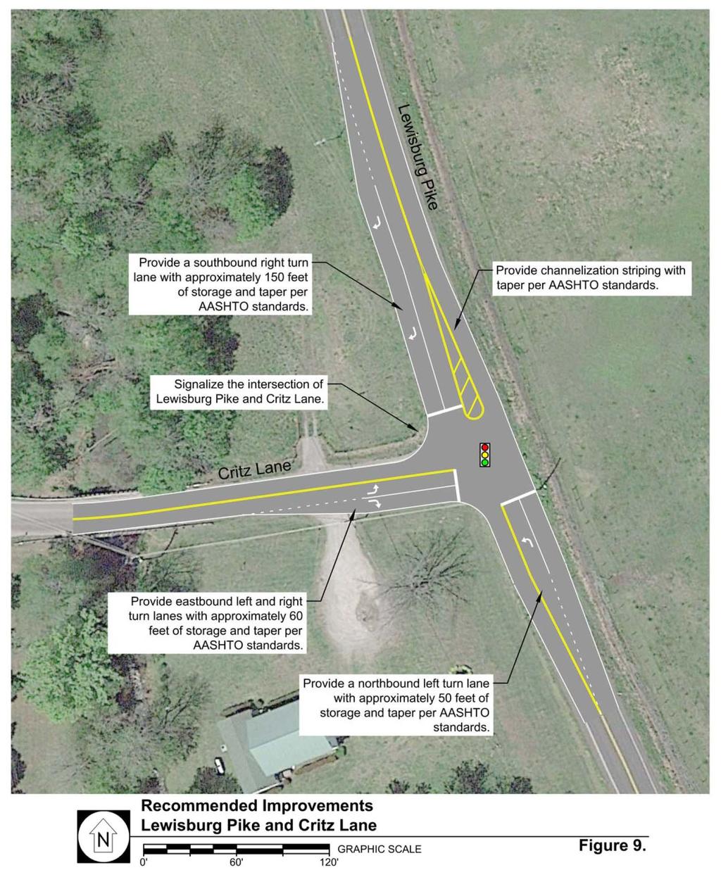
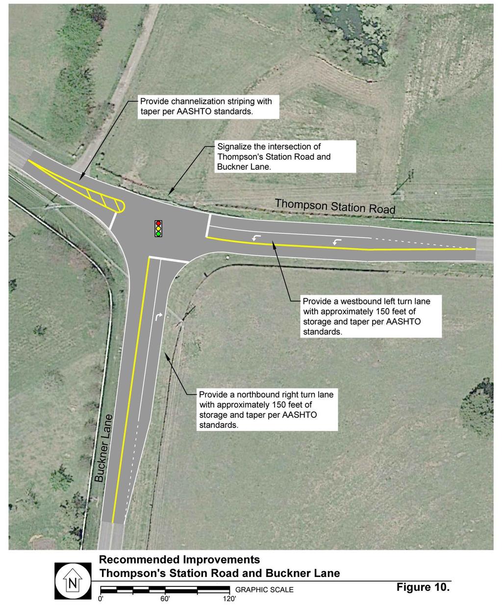
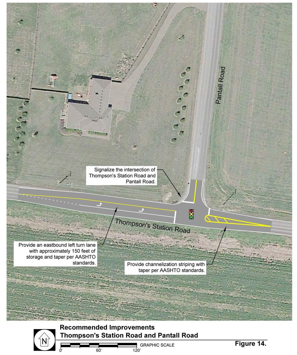
29 TABLE 6: PEAK HOUR LEVELS OF SERVICE 2020 PROJECTED CONDITIONS (CONTINUED) INTERSECTION TURNING MOVEMENT AM Peak Hour LEVEL OF SERVICE Average Approach Delay (sec/veh) PM Peak Hour Average Approach Delay (sec/veh) Thompson s Station Road Segment A N/A B N/A Critz Lane Road Segment A N/A B N/A Pantall Road Road Segment B N/A D N/A Lewisburg Pike Road Segment F N/A F N/A Note: For roadway segments, an overall LOS is presented. Based on the capacity analyses presented, various recommendations were explored in order to improve traffic operations at many key intersections within the study area. These improvements included the following: Widen Columbia Pike to five lanes throughout the study area. Signalize the intersection of Critz Lane and Columbia Pike. Construct a northbound shared through/right turn lane and a southbound through lane on Columbia Pike at Critz Lane. Construct a westbound right turn lane with approximately 250 feet of storage at the intersection of Critz Lane and Columbia Pike. Construct a southbound left turn lane with approximately 300 feet of storage at the intersection of Columbia Pike and Critz Lane. Signalize the intersection of Lewisburg Pike and Critz Lane. Construct a southbound right turn lane with approximately 150 feet of storage and a northbound left turn lane with approximately 50 feet of storage at the intersection of Lewisburg Pike and Critz Lane. Construct an eastbound right turn lane with approximately 60 feet of storage at the intersection of Critz Lane and Lewisburg Pike. Signalize the intersection of Buckner Lane and Thompson s Station Road. Construct a westbound left turn lane with approximately 150 feet of storage at the intersection of Thompson s Station Road and Buckner Lane. Construct a northbound right turn lane with approximately 150 feet of storage at the intersection of Buckner Lane and Thompson s Station Road. Widen Lewisburg Pike to four lanes starting at the 840 westbound ramps and extending approximately 1,500 feet south of the 840 eastbound ramps. Signalize the intersection of Lewisburg Pike and the westbound 840 ramps. Signalize the intersection of Lewisburg Pike and the eastbound 840 ramps. 24 of 41
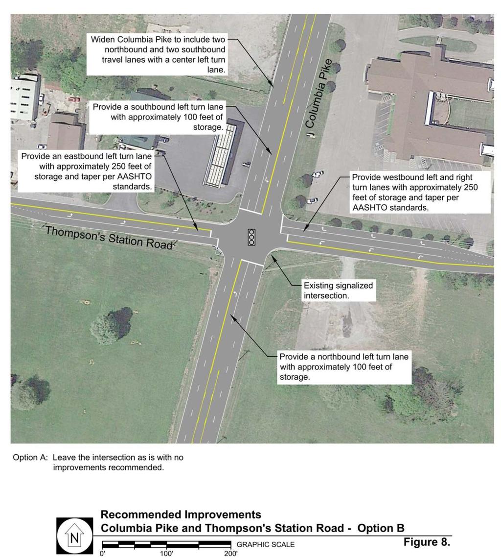
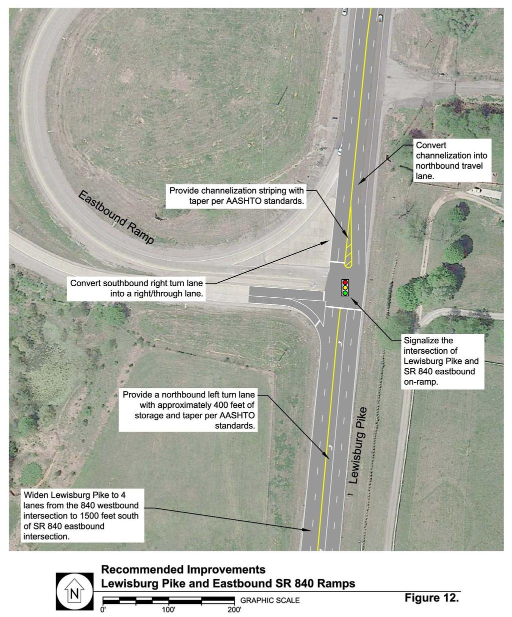
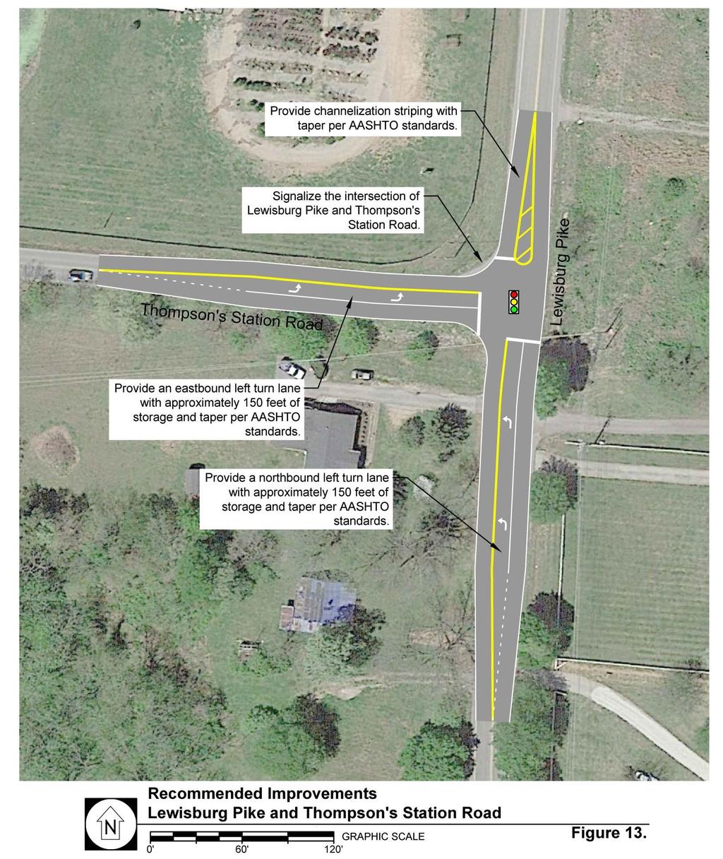
30 Construct a southbound shared through/right turn lane, a northbound left turn lane with approximately 400 feet of storage, and a northbound through lane at the intersection of Lewisburg Pike and the eastbound 840 ramps. Signalize the intersection of Lewisburg Pike and Thompson s Station Road. Construct a northbound left turn lane with approximately 150 feet of storage and an eastbound left turn lane with approximately 150 feet of storage at the intersection of Lewisburg Pike and Thompson s Station Road. Signalize the intersection of Thompson s Station Road and Pantall Road. Construct an eastbound left turn lane with approximately 150 feet of storage at the intersection of Thompson s Station Road and Pantall Road. Construct a roundabout at the intersection of Clayton Arnold Road and Critz Lane. Construct a roundabout at the intersection of Pantall Road and Critz Lane. Coordinate four successive signals on Columbia Pike. Implement coordination on four successive signals on Lewisburg Pike. Coordinate three successive signals on Thompson s Station Road within the study area. Intersection of Columbia Pike and Thompson s Station Road o Option A: The intersection is currently signalized with a left turn lane and a shared through/right turn lane provided on all approaches. Currently, the intersection operates at LOS D and C during the AM and PM peak hours, respectively, with a 30 to 40 second average delay per vehicle. Therefore, the intersection will operate with acceptable levels of service during peak hours with an average daily volume near 20,000 trips just north of the intersection on Columbia Pike. If no improvements are made to the intersection between now and 2020, the delay during the AM and PM peak periods at the intersection will continue to worsen and will be significantly increased with the buildout of Downtown Thompson s Station. However, keeping the number of lanes as existing will allow the intersection to remain more pedestrian friendly and in keeping with the Town s ideals for its downtown than would widening the intersection. o Option B: If the following improvements to the intersection are implemented, then the risk of increased unacceptable delay at the intersection will be mitigated: Widen Columbia Pike to include one left turn lane with approximately 100 feet of storage, one through lane, and one shared through/right turn lane for both northbound and southbound approaches to the intersection. Widen Thompson s Station Road to include one left turn lane with approximately 250 feet of storage and one shared through/right turn lane for the eastbound approach to the intersection. Widen Thompson s Station Road to include one left turn lane with approximately 250 feet of storage, one through lane, and one right turn lane with approximately 250 feet of storage for the westbound approach to the intersection. 25 of 41
31 Capacity analyses were also conducted for the study intersections, and Table 7 presents the operations of the intersections that are expected to be most affected by the recommended improvements. As shown in Table 7, the impacts of both the planned developments and the general traffic growth on the existing roadway network will be manageable by providing these recommended improvements. TABLE 7: PEAK HOUR LEVELS OF SERVICE 2020 PROJECTED CONDITIONS WITH RECOMMENDED IMPROVEMENTS INTERSECTION Columbia Pike & Critz Lane Lewisburg Pike & 840 WB Lewisburg Pike & 840 EB Lewisburg Pike & Critz Lane Columbia Pike & 840 EB Columbia Pike & Thompson s Station Road (Option A) Columbia Pike & Thompson s Station Road (Option B) Columbia Pike & 840 WB Lewisburg Pike & Thompson s Station Thompson s Station & Buckner Lane Thompson s Station & Pantall Road Critz Lane & Clayton Arnold Road Critz Lane & Pantall Road TURNING MOVEMENT Overall Intersection Overall Intersection Overall Intersection Overall Intersection Overall Intersection Overall Intersection Overall Intersection Overall Intersection Overall Intersection Overall Intersection Overall Intersection Roundabout Intersection Roundabout Intersection AM Peak Hour LEVEL OF SERVICE Average Approach Delay (sec/veh) PM Peak Hour Average Approac h Delay (sec/veh) D 48.1 E 58.9 C 24.9 C 33.8 D 38.4 C 30.7 D 51.0 B 13.6 B 16.9 D 39.8 F F >180 C 32.2 E 56.9 C 27.5 F 80.0 C 32.4 D 36.4 C 26.2 C 33.4 C 22.6 D 44.8 A 5.4 A 6.7 A 6.7 B 13.5 Note: For two-way stop controlled intersections, an LOS is presented for each critical turning movement. 26 of 41
32 TABLE 7: PEAK HOUR LEVELS OF SERVICE 2020 PROJECTED CONDITIONS WITH RECOMMENDED IMPROVEMENTS (CONTINUED) INTERSECTION Lewisburg Pike & Harpeth Peytonsville Road Thompson s Station & Clayton Arnold Road TURNING MOVEMENT Southbound Westbound Westbound Eastbound Southbound Southbound AM Peak Hour LEVEL OF SERVICE Average Approach Delay (sec/veh) PM Peak Hour Average Approach Delay (sec/veh) B 14.5 A 8.1 F F F F A 9.3 A 8.3 C 18.2 E 47.0 B 13.7 B 10.8 Thompson s Station Road Segment A N/A B N/A Critz Lane Road Segment A N/A B N/A Pantall Road Road Segment B N/A D N/A Lewisburg Pike Road Segment B N/A B N/A Note: For signalized intersections, an overall LOS is presented. For two-way stop controlled intersections, an LOS is presented for each critical turning movement. 27 of 41
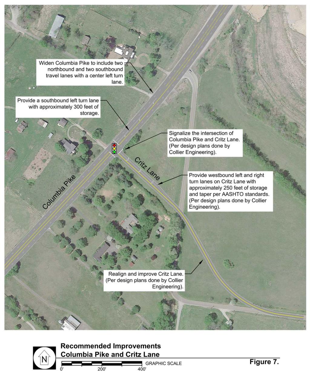
33 4. CONCLUSIONS AND RECOMMENDATIONS Since the previous comprehensive traffic study was prepared in 2007, the Town of Thompson s Station has experienced significant changes in land use and development growth. This study has analyzed the traffic impacts of 11 planned developments within the study area on the roadway network for horizon year The analyses presented in this study indicate that the impacts of the planned developments and the general traffic growth within the study area on the existing roadway network will be manageable by providing the recommendations below, along with the improvements identified in individual traffic impact studies for the planned developments. Ideally, coordination between the Town of Thompson s Station and private developers would allow construction of these improvements to occur simultaneously with private development. General Safety Two-lane roadways having a total width of 20 feet or less should be improved, particularly if new development will introduce additional traffic on the road. The Town of Thompson s Station s Major Thoroughfare Plan should provide cross-section standards for various roadway classifications that can be referenced as development occurs. The roadway geometry of Thompson s Station Road at its intersection with Clayton Arnold Road should be realigned as a means of addressing safety issues. While multiple realignment configurations exist, some may be more feasible as development occurs, creating opportunities for potential coordination regarding right-of-way or public utilities. Signal Warrants It is common for some turning movements, particularly on unsignalized driveways, to experience poor levels of service due to high delays, despite improvements that may be made to the major street. However, due to low side street volumes, these intersections will not likely meet signal warrants. Therefore, these intersections should be monitored in the future to determine if future improvements are needed. Columbia Pike Widen Columbia Pike to include five travel lanes throughout the study area. Signalize the intersection of Critz Lane and Columbia Pike. Construct a northbound shared through/right turn lane and a southbound through lane at the intersection of Columbia Pike and Critz Lane. Construct a westbound right turn lane with approximately 250 feet of storage at the intersection of Critz Lane and Columbia Pike. Construct a southbound left turn lane with approximately 300 feet of storage at the intersection of Columbia Pike and Critz Lane. Coordinate four successive signals along Columbia Pike within the study area. 28 of 41
34 Thompson s Station Road Signalize the intersection of Buckner Lane and Thompson s Station Road. Construct a westbound left turn lane with approximately 150 feet of storage at the intersection of Thompson s Station Road and Buckner Lane. Construct a northbound right turn lane with approximately 150 feet of storage at the intersection of Buckner Lane and Thompson s Station Road. Construct an eastbound left turn lane with approximately 150 feet of storage at the intersection of Thompson s Station Road and Lewisburg Pike. Signalize the intersection of Thompson s Station Road and Pantall Road. Construct an eastbound left turn lane with approximately 150 feet of storage at the intersection of Thompson s Station Road and Pantall Road. Coordinate three successive signals on Thompson s Station Road within the study area. Intersection of Columbia Pike and Thompson s Station Road Option A: The intersection is currently signalized with a left turn lane and a shared through/right turn lane provided on all approaches. Currently, the intersection operates at LOS D and C during the AM and PM peak hours, respectively, with a 30 to 40 second average delay per vehicle. Therefore, the intersection will operate with acceptable levels of service during peak hours with an average daily volume near 20,000 trips just north of the intersection on Columbia Pike. If no improvements are made to the intersection between now and 2020, the delay during the AM and PM peak periods at the intersection will continue to worsen and will be significantly increased with the buildout of Downtown Thompson s Station. However, keeping the number of lanes as existing will allow the intersection to remain more pedestrian friendly and in keeping with the Town s ideals for its downtown than would widening the intersection. Option B: If the following improvements to the intersection are implemented, then the risk of increased unacceptable delay at the intersection will be mitigated: Widen Columbia Pike to include one left turn lane with approximately 100 feet of storage, one through lane, and one shared through/right turn lane for both northbound and southbound approaches to the intersection. Widen Thompson s Station Road to include one left turn lane with approximately 250 feet of storage and one shared through/right turn lane for the eastbound approach to the intersection. Widen Thompson s Station Road to include one left turn lane with approximately 250 feet of storage, one through lane, and one right turn lane with approximately 250 feet of storage for the westbound approach to the intersection. 29 of 41
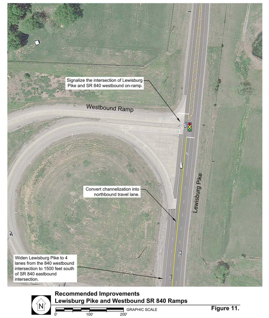
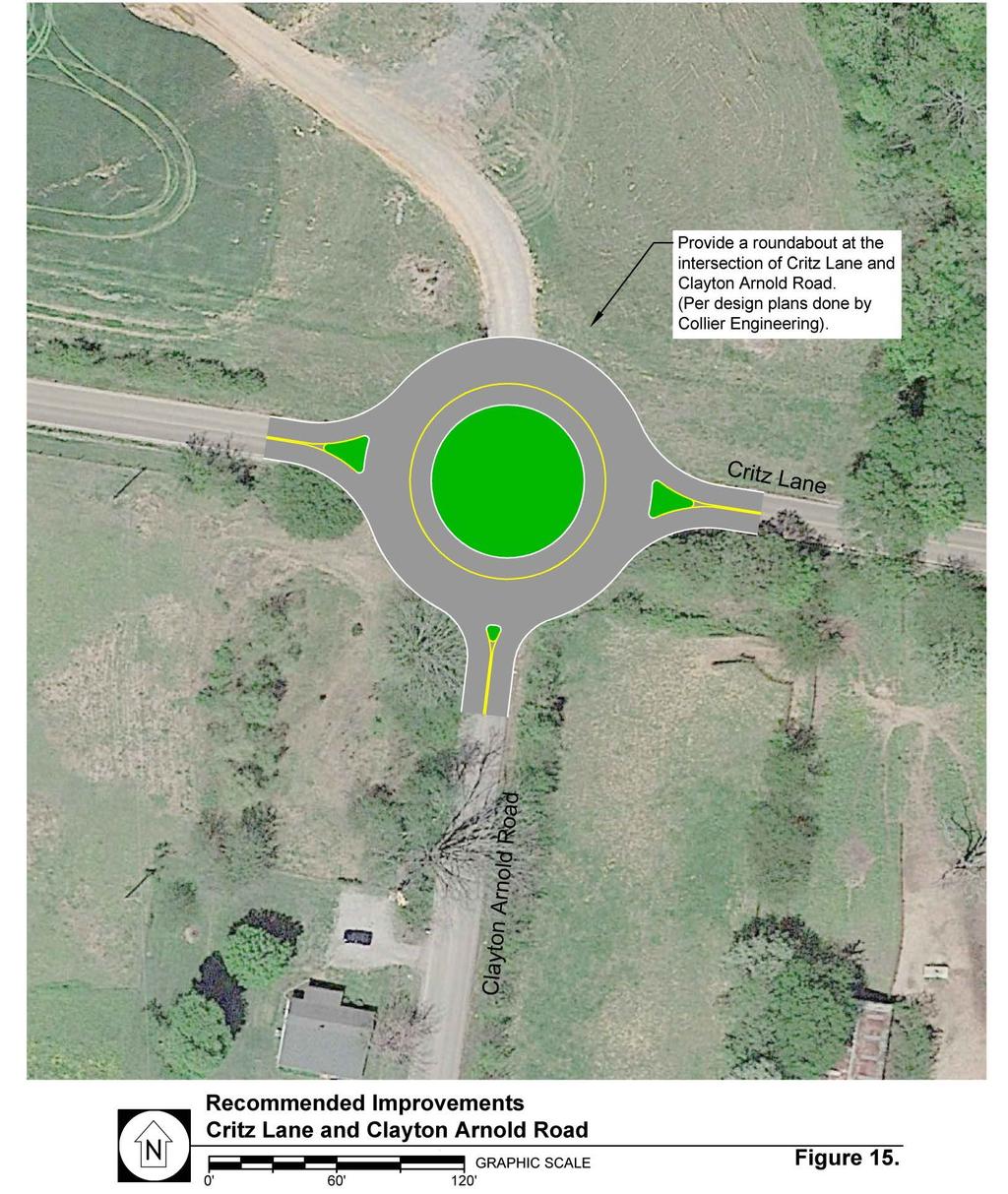
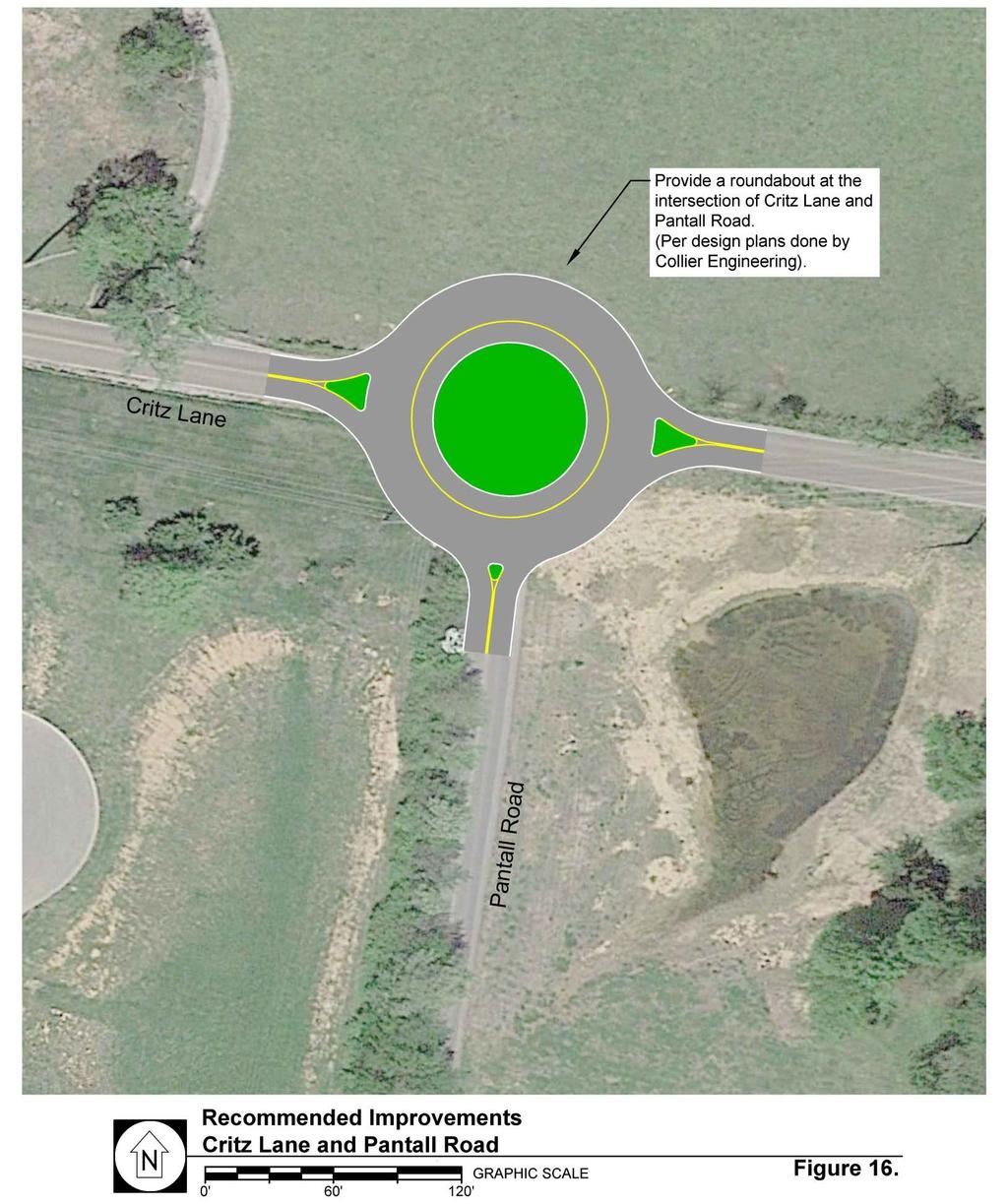
35 Lewisburg Pike Signalize the intersection of Lewisburg Pike and Critz Lane. Construct a southbound right turn lane with approximately 150 feet of storage and a northbound left turn lane with approximately 50 feet of storage at the intersection of Lewisburg Pike and Critz Lane. Construct an eastbound right turn lane with approximately 60 feet of storage at the intersection of Critz Lane and Lewisburg Pike. Widen Lewisburg Pike to include four travel lanes beginning at the 840 westbound ramps extending approximately 1,500 feet south of the 840 eastbound ramps. Signalize the intersection of Lewisburg Pike and the westbound 840 ramps. Signalize the intersection of Lewisburg Pike and the eastbound 840 ramps. Construct a southbound shared through/right turn lane, a northbound left turn with approximately 400 feet of storage, and a northbound through lane at the intersection of Lewisburg Pike and the eastbound 840 ramps. Signalize the intersection of Lewisburg Pike and Thompson s Station Road. Construct a northbound left turn lane with approximately 150 feet of storage at the intersection of Lewisburg Pike and Thompson s Station Road. Implement coordination on four successive signals on Lewisburg Pike within the study area. Critz Lane Construct a roundabout at the intersection of Clayton Arnold Road and Critz Lane. Construct a roundabout at the intersection of Pantall Road and Critz Lane. The recommended intersection improvements within the study area are shown in Figures As previously noted, this traffic study deals with growth impacts over a relatively short, 5-year planning horizon ( ). A longer-term strategy for the roadway network should be further developed in a local Major Thoroughfare Plan. When supplemented with long-term roadway improvements, the short-term recommended improvements included in this study are expected to meet the Town of Thompson s Station growing transportation needs. 30 of 41
36 31 of 41
37 32 of 41
38 33 of 41
39 34 of 41
40 35 of 41
41 36 of 41
42 37 of 41
43 38 of 41
44 39 of 41
45 40 of 41
46 STUDY ADDENDUM For information regarding the Intersection of Columbia Pike (SR 6) and Tollgate Boulevard Subsequent to the completion of the Town s Comprehensive Traffic Study Update, RPM was asked to provide additional information regarding the intersection of Columbia Pike and Tollgate Boulevard, located just north of the study area. While the Tollgate Village development was incorporated into the study (to determine what impact this development will have on roads and intersections within the study area), the Tollgate Boulevard intersection was not specifically analyzed. Specifically in question is whether signalization of the Tollgate Boulevard intersection is justified. The Manual on Uniform Traffic Control Devices (MUTCD) sets forth nine different warrants that have been developed by the traffic engineering profession to facilitate the determination of whether a signal is warranted. These warrants include minimum conditions that normally indicate when a traffic signal is justified at a particular location. The MUTCD states that "traffic control signals should not be installed unless one or more of the signal warrants in the manual are met." The meeting of a warrant does not require installation of a traffic signal. In August 2014, the Tennessee Department of Transportation conducted a signal warrant analysis at the intersection. The traffic counts made on August 13, 2014 confirmed that traffic volumes at the intersection met MUTCD s Warrant 2 for Four Hour Vehicle Volumes. Since that time, it is presumed that traffic has remained steady or grown and therefore installing signalized traffic control at the intersection remains warranted. The raw count and signal warrant analysis data obtained from TDOT are provided in Appendix E. 41 of 41
Traffic Impact Study. Roderick Place Columbia Pike Thompson s Station, TN. Transportation Group, LLC Traffic Engineering and Planning
 F i s c h b a c h Transportation Group, LLC Traffic Engineering and Planning Traffic Impact Study Roderick Place Columbia Pike Thompson s Station, TN Prepared March 2016 Ms. Gillian L. Fischbach, P.E.,
Traffic Impact Analysis Chatham County Grocery Chatham County, NC
 Chatham County Grocery Chatham County, NC TABLE OF CONTENTS 1. INTRODUCTION... 1 1.1. Location and Study Area... 1 1.2. Proposed Land Use and Access... 2 1.3. Adjacent Land Uses... 2 1.4. Existing ways...
Traffic Impact Analysis Walton Acres at Riverwood Athletic Club Clayton, NC
 Traffic Impact Analysis Walton Acres at Riverwood Athletic Club Clayton, NC 1. TABLE OF CONTENTS INTRODUCTION...1 1.1. Site Location and Study Area...1 1.2. Proposed Land Use and Site Access...2 1.3.
Glenn Avenue Corridor Traffic Operational Evaluation
 Glenn Avenue Corridor Traffic Operational Evaluation PREPARED FOR: THE CITY OF AUBURN PREPARED BY: DECEMBER 2007 Glenn Avenue Corridor Study--Auburn, Alabama TABLE OF CONTENTS Introduction... 1 Background
Shockoe Bottom Preliminary Traffic and Parking Analysis
 Shockoe Bottom Preliminary Traffic and Parking Analysis Richmond, Virginia August 14, 2013 Prepared For City of Richmond Department of Public Works Prepared By 1001 Boulders Pkwy Suite 300, Richmond, VA
King Soopers #116 Thornton, Colorado
 Traffic Impact Study King Soopers #116 Thornton, Colorado Prepared for: Galloway & Company, Inc. 1.0 EXECUTIVE SUMMARY King Soopers #116, a grocery marketplace anchored commercial development, is proposed
5858 N COLLEGE, LLC N College Avenue Traffic Impact Study
 5858 N COLLEGE, LLC nue Traffic Impact Study August 22, 2016 Contents Traffic Impact Study Page Preparer Qualifications... 1 Introduction... 2 Existing Roadway Conditions... 5 Existing Traffic Conditions...
Highway 111 Corridor Study
 Highway 111 Corridor Study June, 2009 LINCOLN CO. HWY 111 CORRIDOR STUDY Draft Study Tea, South Dakota Prepared for City of Tea Sioux Falls Metropolitan Planning Organization Prepared by HDR Engineering,
TRAFFIC IMPACT STUDY And A TRAFFIC SIGNAL WARRANT ANALYSIS FOR A SENIOR LIVING AND APARTMENT DEVELOPMENT
 TRAFFIC IMPACT STUDY And A TRAFFIC SIGNAL WARRANT ANALYSIS FOR A SENIOR LIVING AND APARTMENT DEVELOPMENT DEERFIELD TOWNSHIP, WARREN COUNTY, OHIO Nantucket Circle and Montgomery Road () Prepared for: ODLE
6060 North Central Expressway Mixed-Use Site Dallas, Texas
 Volume 1 Traffic Impact Analysis 6060 North Central Expressway Mixed-Use Site Dallas, Texas April 30, 2018 Kimley-Horn and Associates, Inc. Dallas, Texas Project #063238300 Registered Firm F-928 Traffic
DUNBOW ROAD FUNCTIONAL PLANNING
 DUNBOW ROAD FUNCTIONAL PLANNING Final Report August 3, 216 #31, 316 5th Avenue NE Calgary, AB T2A 6K4 Phone: 43.273.91 Fax: 43.273.344 wattconsultinggroup.com Dunbow Road Functional Planning Final Report
TRAFFIC ASSESSMENT River Edge Colorado
 TRAFFIC ASSESSMENT River Edge Colorado Submitted by: Fehr & Peers 621 17th Street, Ste. 231 Denver, CO 8293 (33) 296-43 December, 21 App. M-2 Traffic Assessment River Edge Colorado December 21 TABLE OF
Walmart (Store # ) 60 th Street North and Marion Road Sioux Falls, South Dakota
 60 th Street North and Marion Road Sioux Falls, South Dakota") Walmart (Store #4865-00) 60 th Street North and Marion Road Sioux Falls, South Dakota Prepared for: Wal-Mart Stores, Inc. Bentonville, Arkansas Prepared by: Kimley-Horn and Associates, Inc. ã2013 Kimley-Horn
Walmart (Store #4865-00) 60 th Street North and Marion Road Sioux Falls, South Dakota Prepared for: Wal-Mart Stores, Inc. Bentonville, Arkansas Prepared by: Kimley-Horn and Associates, Inc. ã2013 Kimley-Horn
Chapter 4 Traffic Analysis
 Chapter 4 Traffic Analysis PURPOSE The traffic analysis component of the K-68 Corridor Management Plan incorporates information on the existing transportation network, such as traffic volumes and intersection
TRAFFIC STUDY GUIDELINES Clarksville Street Department
 TRAFFIC STUDY GUIDELINES Clarksville Street Department 9/1/2009 Introduction Traffic studies are used to help the city determine potential impacts to the operation of the surrounding roadway network. Two
TRANSPORTATION ANALYSIS REPORT US Route 6 Huron, Erie County, Ohio
 TRANSPORTATION ANALYSIS REPORT US Route 6 Huron, Erie County, Ohio December 12, 2012 Prepared for: The City of Huron 417 Main Huron, OH 44839 Providing Practical Experience Technical Excellence and Client
Traffic Impact Study. Westlake Elementary School Westlake, Ohio. TMS Engineers, Inc. June 5, 2017
 TMS Engineers, Inc. Traffic Impact Study Westlake Elementary School Westlake, Ohio June 5, 2017 Prepared for: Westlake City Schools - Board of Education 27200 Hilliard Boulevard Westlake, OH 44145 TRAFFIC
List of Attachments. Location Map... Site Plan... City of Lake Elsinore Circulation Element... City of Lake Elsinore Roadway Cross-Sections...
 List of Attachments Exhibits Location Map... Site Plan... City of Lake Elsinore Circulation Element... City of Lake Elsinore Roadway Cross-Sections... Existing Lane Geometry and Traffic Controls... Existing
THIS PAGE LEFT BLANK INTENTIONALLY
 GA SR 25 Spur at Canal Road Transportation Impact Analysis PREPARED FOR GLYNN COUNTY, GEORGIA 1725 Reynolds Street, Suite 300 Brunswick, Georgia 31520 PREPARED BY 217 Arrowhead Boulevard Suite 26 Jonesboro,
Project Report. South Kirkwood Road Traffic Study. Meadows Place, TX October 9, 2015
 Meadows Place, TX October 9, 2015 Contents 1 Introduction... 1 2 Data Collection... 1 3 Existing Roadway Network... 2 4 Traffic Volume Development... 2 5 Warrant Analysis... 3 6 Traffic Control Alternative
Donahue Drive Corridor Traffic Operational Evaluation
 Donahue Drive Corridor Traffic Operational Evaluation PREPARED FOR: THE CITY OF AUBURN PREPARED BY: JANUARY 2007 Donahue Drive Corridor Study--Auburn, Alabama TABLE OF CONTENTS Introduction... 1 Background
TRAFFIC IMPACT STUDY. Creekside Thornton, Colorado. For. August 2015 November 2015 Revised: August Prepared for:
 TRAFFIC IMPACT STUDY For Creekside Thornton, Colorado August 215 November 215 Revised: August 216 Prepared for: Jansen Strawn Consulting Engineers 45 West 2 nd Avenue Denver, Colorado 8223 Prepared by:
Henderson Avenue Mixed-Use Development
 Zoning Case: Z145-3 Traffic Impact Analysis Henderson Avenue Mixed-Use Development Dallas, TX October 26 th, 216 Kimley-Horn and Associates, Inc. Dallas, Texas Project #644827 Registered Firm F-928 Traffic
Traffic Circulation Study for Neighborhood Southwest of Mockingbird Lane and Airline Road, Highland Park, Texas
 ARIZONA TEXAS NEW MEXICO OKLAHOMA February 13, 2015 Mr. Meran Dadgostar P.E., R.S. Town of Highland Park 4700 Drexel Dr. Highland Park, Texas 75205 Re: Traffic Circulation Study for Neighborhood Southwest
Traffic Impact Study WestBranch Residential Development Davidson, NC March 2016
 Traffic Impact Study WestBranch Residential Development Davidson, NC March 216 TRAFFIC IMPACT STUDY FOR THE WestBranch Residential Development LOCATED IN DAVIDSON, NC Prepared For: Lennar Carolinas, LLC
METHODOLOGY. Signalized Intersection Average Control Delay (sec/veh)
") Chapter 5 Traffic Analysis 5.1 SUMMARY US /West 6 th Street assumes a unique role in the Lawrence Douglas County transportation system. This principal arterial street currently conveys commuter traffic
Chapter 5 Traffic Analysis 5.1 SUMMARY US /West 6 th Street assumes a unique role in the Lawrence Douglas County transportation system. This principal arterial street currently conveys commuter traffic
Evaluation of M-99 (Broad Street) Road Diet and Intersection Operational Investigation
 Road Diet and Intersection Operational Investigation") Evaluation of M-99 (Broad Street) Road Diet and Intersection Operational Investigation City of Hillsdale, Hillsdale County, Michigan June 16, 2016 Final Report Prepared for City of Hillsdale 97 North Broad
Evaluation of M-99 (Broad Street) Road Diet and Intersection Operational Investigation City of Hillsdale, Hillsdale County, Michigan June 16, 2016 Final Report Prepared for City of Hillsdale 97 North Broad
3.2.2 Proposed Road Network within Phase 1B Lands
 3.2.2 Proposed Road Network within Phase 1B Lands Figure 3.1 also shows the proposed road network within the Premier Gateway Phase 1B Employment Area lands, which features two collector roads providing
Traffic Impact Study Little Egypt Road Development Denver, North Carolina June 2017
 Traffic Impact Study Little Egypt Road Development Denver, North arolina June 2017 N. Little Egypt Road DQ\ QDQFLQJ VDOHV RU RWKHU SHUIRUPDQFH EDVHG FULWHULD Proposed Site Driveways Site Driveway 1 TRAFFI
Walton Acres at Riverwood Athletic Club Clayton, North Carolina
 9. CONCLUSIONS This Traffic Impact Analysis Update was conducted to determine the potential traffic impacts of the proposed Walton Acres at Riverwood Athletic Club residential development, located east
Harrah s Station Square Casino
 Transportation Analysis Harrah s Station Square Casino Pittsburgh, Pennsylvania Submitted To: City of Pittsburgh and Pennsylvania Gaming Control Board Prepared By: DKS Associates GAI Consultants December
OTTAWA TRAIN YARDS PHASE 3 DEVELOPMENT CITY OF OTTAWA TRANSPORTATION IMPACT STUDY. Prepared for:
 OTTAWA TRAIN YARDS PHASE 3 DEVELOPMENT CITY OF OTTAWA TRANSPORTATION IMPACT STUDY Prepared for: The Ottawa Train Yards Inc. 223 Colonnade Road South, Suite 212 Nepean, Ontario K2E 7K3 January 17, 2012
TABLE OF CONTENTS TABLE OF CONTENTS... I APPENDICES... III LIST OF EXHIBITS... V LIST OF TABLES... VII LIST OF ABBREVIATED TERMS...
 TABLE OF CONTENTS TABLE OF CONTENTS... I APPENDICES... III LIST OF EXHIBITS... V LIST OF TABLES... VII LIST OF ABBREVIATED TERMS... IX 1 INTRODUCTION... 1 1.1 Project Overview... 1 1.2 Analysis Scenarios...
DRAFT. Corridor study. Honeysuckle Road. October Prepared for the City of Dothan, AL. Prepared by Gresham, Smith and Partners
 DRAFT Corridor study Honeysuckle Road October 2017 Prepared for the City of Dothan, AL Prepared by TABLE OF CONTENTS SECTION I... 1 STUDY SUMMARY... 1 INTRODUCTION... 1 CONCLUSIONS... 5 SECTION II... 7
ALLEY 24 TRAFFIC STUDY
 ALLEY 24 TRAFFIC STUDY in City of Frostburg, Maryland January 2013 3566 Teays Valley Road Hurricane, WV Office: (304) 397-5508 www.denniscorporation.com Alley 24 Traffic Study January 2013 Frostburg, Maryland
TABLE TRAFFIC ANALYSIS SCENARIOS
 4.11 TRANSPORTATION The potential traffic impacts of the proposed project are evaluated in the Buena Park Beach/Orangethorpe Mixed Use Project Traffic Analysis (Traffic Analysis) by Austin-Foust Associates
 TRAFFIC IMPACT STUDY CANYON HILLS PROJECT LOS ANGELES, CALIFORNIA INTRODUCTION This traffic analysis has been conducted to identify and evaluate the potential traffic impacts of the proposed Canyon Hills
Route 28 (South Orleans Road)/Route 39 (Harwich Road)/Quanset Road Intersection
/Route 39 (Harwich Road)/Quanset Road Intersection") TRAFFIC FEASIBILITY STUDY Route 28 (South Orleans Road)/Route 39 (Harwich Road)/Quanset Road Intersection Orleans, Massachusetts Prepared for: Town of Orleans Prepared by: Fay, Spofford & Thorndike, LLC
TRAFFIC FEASIBILITY STUDY Route 28 (South Orleans Road)/Route 39 (Harwich Road)/Quanset Road Intersection Orleans, Massachusetts Prepared for: Town of Orleans Prepared by: Fay, Spofford & Thorndike, LLC
REDEVELOPMENT TRAFFIC IMPACT STUDY
 REDEVELOPMENT TRAFFIC IMPACT STUDY For Wendy s Parker, Colorado January 215 Prepared for: Sterling Design Associates, LLC 29 W. Littleton Boulevard #3 Littleton, Colorado 812 Prepared by: 1233 Airport
PRELIMINARY DRAFT WADDLE ROAD / I-99 INTERCHANGE PROJECT ALTERNATIVE ANALYSIS FINAL TRAFFIC SUMMARY REPORT
 PRELIMINARY DRAFT WADDLE ROAD / I-99 INTERCHANGE PROJECT ALTERNATIVE ANALYSIS FINAL TRAFFIC SUMMARY REPORT Prepared by: In Association with: November 2013 EXECUTIVE SUMMARY Patton Township, in partnership
FINAL DESIGN TRAFFIC TECHNICAL MEMORANDUM
 FINAL DESIGN TRAFFIC TECHNICAL MEMORANDUM July 2014 FINAL (SR 43) Project Development and Environment Study From State Road 60 (Adamo Drive) to I-4 (SR 400) Hillsborough County, Florida Work Program Item
TRAFFIC IMPACT ANALYSIS
 TRAFFIC IMPACT ANALYSIS FOR THE CHAMPAIGN UNIT#4 SCHOOL DISTRICT PROPOSED HIGH SCHOOL (SPALDING PARK SITE) IN THE CITY OF CHAMPAIGN Final Report Champaign Urbana Urbanized Area Transportation Study 6/24/2014
Volume 1 Traffic Impact Analysis. Texas Odyssey TIA Dallas, Texas. Kimley-Horn and Associates, Inc. Dallas, Texas. May 23, 2018
 Volume 1 Traffic Impact Analysis Texas Odyssey TIA Dallas, Texas May 23, 2018 Kimley-Horn and Associates, Inc. Dallas, Texas Project #064529800 Registered Firm F-928 Traffic Impact Analysis Texas Odyssey
FRONT RANGE CROSSINGS TRAFFIC IMPACT STUDY
 FRONT RANGE CROSSINGS TRAFFIC IMPACT STUDY Prepared for: City of Thornton And Colorado Department of Transportation Prepared by: 11 Blake Street, Suite 2 Denver, Colorado 822 Contact: Brian Bern, PE, PTOE
City of Homewood Transportation Plan
 City of Homewood Transportation Plan Prepared for: City of Homewood, Alabama Prepared by: Skipper Consulting, Inc. May 2007 TABLE OF CONTENTS INTRODUCTION... 1 BACKGROUND INFORMATION... 1 EXISTING TRANSPORTATION
Transportation Impact Study for Abington Terrace
 Transportation Impact Study for Abington Terrace Abington Township, Montgomery County, PA Sandy A. Koza, P.E., PTOE PA PE License Number PE059911 Prepared by McMahon Associates, Inc. 425 Commerce Drive,
Technical Memorandum TRAFFIC IMPACT STUDY. RIDLEY ROAD CONVENIENCE STORE Southampton County, VA. Prepared for: Mr. David Williams.
 Technical Memorandum TRFFIC IMPCT STUDY RIDLEY ROD CONVENIENCE STORE Southampton County, V Prepared for: Mr. David Williams By: Charles Smith, P.E., PTOE EPR Charlottesville, V July 2014 1 TBLE OF CONTENTS
Appendix C. NORTH METRO STATION AREA TRAFFIC IMPACT STATEMENT 88th Avenue Station
 Appendix C NORTH METRO STATION AREA TRAFFIC IMPACT STATEMENT 88th Avenue Station Prepared for: Regional Transportation Department and URS Corporation as part of the North Metro EIS David Evans and Associates,
D.13 Transportation and Traffic
 This section addresses transportation and traffic issues and impacts related to the Proposed Project. Section D.13.1 provides a description of the affected environment for the Proposed Project. Applicable
Figure 1: Vicinity Map of the Study Area
 ARIZONA TEXAS NEW MEXICO OKLAHOMA May 5, 2016 Mr. Anthony Beach, P.E. BSP Engineers 4800 Lakewood Drive, Suite 4 Waco, Texas 76710 Re: Intersection and Access Analysis along Business 190 in Copperas Cove
Waterford Lakes Small Area Study
 Waterford Lakes Small Area Study Existing Traffic Conditions PREPARED FOR: ORANGE COUNTY PUBLIC WORKS DEPARTMENT TRAFFIC ENGINEERING DIVISION ORLANDO, FLORIDA PREPARED WITH: INWOOD CONSULTING ENGINEERS
Cricket Valley Energy Project Dover, NY Updated Traffic Impact Study
 Updated Traffic Impact Study Community Resources 6.3A Traffic and Transportation Amended This amended Traffic Study incorporates comments from NYSDOT, provided after their review of the original Traffic
PINESTONE TRAFFIC IMPACT STUDY Travelers Rest, South Carolina
 PINESTONE TRAFFIC IMPACT STUDY Travelers Rest, South Carolina Prepared for Longbranch Development Prepared by January 13, 219 ii Table of Contents Subject Page Signature Page... i Table of Contents...
Abrams Associates. Transportation Impact Analysis. City of Rocklin. Prepared for: David Mohlenbrok City of Rocklin 4081 Alvis Court Rocklin, CA 95677
 Transportation Impact Analysis Sierra College Boulevard Commercial Project City of Rocklin Prepared for: David Mohlenbrok City of Rocklin 081 Alvis Court Rocklin, CA 95677 Prepared by: 1875 Olympic Boulevard,
List of Exhibits...ii
 One Brickell Traffic Study TABLE OF CONTENTS List of Exhibits...ii EXECUTIVE SUMMARY...1 1. INTRODUCTION...2 1.1 Study Area...2 1.2 Study Objective...5 2. EXISTING TRAFFIC CONDITIONS...6 2.1 Data Collection...6
Date: September 7, Project #: Re: Spaulding Youth Center Northfield, NH Property. Traffic Impact Study
 To: Ms. Susan C. Ryan Spaulding Youth Center 72 Spaulding Road Northfield, NH 03276 Date: September 7, 2017 Project #: 52455.00 From: Robin Bousa Director of Transportation Systems Re: Spaulding Youth
TRAFFIC IMPACT STUDY CRITERIA
 Chapter 6 - TRAFFIC IMPACT STUDY CRITERIA 6.1 GENERAL PROVISIONS 6.1.1. Purpose: The purpose of this document is to outline a standard format for preparing a traffic impact study in the City of Steamboat
EXECUTIVE SUMMARY. Page 1 of 6
 EXECUTIVE SUMMARY The purpose of this report is to identify conformance with the original traffic impact study for the proposed retail development on Lot 5 of Riverdale Retail Filing No. 1 located on the
Intersection Traffic Control Feasibility Study
 Intersection Traffic Control Feasibility Study CSAH 9 at CSAH 60 (185th Avenue) Prepared For: Dakota County Transportation Department Western Service Center 14955 Galaxie Avenue, 3rd Floor Apple Valley,
Table of Contents FIGURES TABLES APPENDICES. Traffic Impact Study Hudson Street Parking Garage MC Project No.: A Table of Contents
 Traffic Impact Study Hudson Street Parking Garage MC Project No.: 151714A Table of Contents Table of Contents I. INTRODUCTION... 2 II. EXISTING CONDITIONS... 5 III. 215 EXISTING TRAFFIC CONDITIONS... 6
DIMARCO CANANDAIGUA PROPERTIES HOUSING PROJECT CANANDAIGUA, ONTARIO COUNTY, NEW YORK
 TRAFFIC IMPACT STUDY FOR THE DIMARCO CANANDAIGUA PROPERTIES HOUSING PROJECT CANANDAIGUA, ONTARIO COUNTY, NEW YORK MARCH 14, 2017 PREPARED FOR: 1950 Brighton Henrietta Town Line Rd Rochester, NY 14623 PREPARED
FINAL Albertville Business Park AUAR Update Traffic Study
 FINAL Albertville Business Park AUAR Update Traffic Study Prepared for City of Albertville, MN July 20, 2017 SRF No. 10060.00 Table of Contents Introduction... 1 Existing Conditions... 1 Data Collection...
Cheyenne Metropolitan Planning Organization
 Dell Range Boulevard Corridor Study PHASE II SECTION 20 DRAFT Prepared for: Cheyenne Metropolitan Planning Organization November 20, 2015 (Section 20 is bordered by Powderhouse Road on the west, Storey
Grant Avenue Streetscape
 REPORT TYPE GOES HERE Grant Avenue Streetscape PREPARED FOR City of Manassas 9027 Center Street Manassas, VA 20110 PREPARED BY 8300 Boone Boulevard Suite 700 Vienna, Virginia 22182 571.389.8121 July 31,
Meadowlake Ranch Traffic Impact Analysis (LSC #184600) August 27, 2018
 August 27, 2018") LSC TRANSPORTATION CONSULTANTS, INC. 545 East Pikes Peak Avenue, Suite 210 Colorado Springs, CO 80903 (719) 633-2868 FAX (719) 633-5430 E-mail: lsc@lsctrans.com Website: http://www.lsctrans.com Traffic
LSC TRANSPORTATION CONSULTANTS, INC. 545 East Pikes Peak Avenue, Suite 210 Colorado Springs, CO 80903 (719) 633-2868 FAX (719) 633-5430 E-mail: lsc@lsctrans.com Website: http://www.lsctrans.com Traffic
Chapter 16: Traffic and Parking A. INTRODUCTION
 Chapter 6: Traffic and Parking A. ITRODUCTIO This chapter examines the potential traffic and parking impacts of the proposed Fresh Kills Park roads. The analysis of transit and pedestrians is presented
Bridge Street Corridor Study Report
 Bridge Street Corridor Study Report Prepared for: Prepared by: BRIDGE STREET CORRIDOR STUDY REPORT PREPARED FOR: CITY OF ARROYO GRANDE COMMUNITY DEVELOPMENT DEPARTMENT 300 EAST BRANCH STREET ARROYO GRANDE,
4. ENVIRONMENTAL IMPACT ANALYSIS 9. TRANSPORTATION AND TRAFFIC
 4. ENVIRONMENTAL IMPACT ANALYSIS 9. TRANSPORTATION AND TRAFFIC 4.9.1 INTRODUCTION The following section addresses the Proposed Project s impact on transportation and traffic based on the Traffic Study
Magnolia Place. Traffic Impact Analysis. Prepared for: City of San Mateo. Prepared by: Hexagon Transportation Consultants, Inc.
 Magnolia Place Traffic Impact Analysis Prepared for: City of San Mateo Prepared by: Hexagon Transportation Consultants, Inc. Updated January 4, 2010 Table of Contents 1. Introduction...1 2. Existing Conditions...6
Northwest Corridor Project Interchange Modification, Interchange Justification and System Analysis Report Reassessment (Phase I)
") Northwest Corridor Project Interchange Modification, Interchange Justification and System Analysis Report Reassessment (Phase I) Introduction The Georgia Department of Transportation (GDOT) prepared a
Northwest Corridor Project Interchange Modification, Interchange Justification and System Analysis Report Reassessment (Phase I) Introduction The Georgia Department of Transportation (GDOT) prepared a
MEMORANDUM. Our project study area included the following locations:
 MEMORANDUM Date: To: From: Subject: Najib O. Habesch Nick M. Fomenko, PE, PTOE Bushnell Park North Traffic Assessment BETA Project #: 4461 As part of our contract to undertake the design of the Bushnell
TRANSPORTATION IMPACT STUDY PROPOSED RIVERFRONT 47 MIXED USE DEVELOPMENT
 November 2016 TRANSPORTATION IMPACT STUDY PROPOSED RIVERFRONT 47 MIXED USE DEVELOPMENT & Aspinwall Borough, Sharpsburg Borough & O Hara Township, Allegheny County, Pennsylvania Prepared for: Riverfront
INDUSTRIAL BUILDING 3009 HAWTHORNE ROAD CITY OF OTTAWA TRANSPORTATION OVERVIEW REVISED. Prepared for: Canada Inc.
 INDUSTRIAL BUILDING 3009 HAWTHORNE ROAD CITY OF OTTAWA TRANSPORTATION OVERVIEW REVISED Prepared for: 7849648 Canada Inc. Octiober 1, 2015 114-598 Overview_2.doc D. J. Halpenny & Associates Ltd. Consulting
Atlanta Braves Stadium and Mixed- Use Development
 Transportation Analysis Atlanta Braves Stadium and Mixed- Use Development DRI #2381 Cobb County, Georgia Prepared for: BRED Co., LLC Prepared by: Kimley-Horn and Associates, Inc. 817 West Peachtree Street
HILTON GARDEN INN HOTEL HOTEL EXPANSION 2400 ALERT ROAD, OTTAWA TRANSPORTATION BRIEF. Prepared for:
 HILTON GARDEN INN HOTEL HOTEL EXPANSION 2400 ALERT ROAD, OTTAWA TRANSPORTATION BRIEF Prepared for: Bona Building & Management Co. Ltd. Place Vanier, 333 North River Road Vanier, Ontario K1L 8B9 October
Truck Climbing Lane Traffic Justification Report
 ROUTE 7 (HARRY BYRD HIGHWAY) WESTBOUND FROM WEST MARKET STREET TO ROUTE 9 (CHARLES TOWN PIKE) Truck Climbing Lane Traffic Justification Report Project No. 6007-053-133, P 101 Ι UPC No. 58599 Prepared by:
Memorandum Pershing Road Suite 400 Kansas City, MO Tel Fax
 Memorandum 2400 Pershing Road Suite 400 Kansas ity, MO 64108 Tel 816 329 8600 Fax 816 329 8601 www.transystems.com To: Mr. avid Gurss Kansas epartment of Transportation wight. Eisenhower State Office ldg.
Traffic Study North Shore School District 112
 Traffic Study North Shore School District 112 Proposed Expansion of Northwood Junior High School Prepared By: May 1, 2015 1. Introduction Kenig, Lindgren, O Hara, Aboona, Inc. (KLOA, Inc.) has been retained
Clay Street Realignment Project Traffic Study
 Final Clay Street Realignment Project Traffic Study November 24, 2009 Prepared for: City of Placerville RS07-2466 2990 Lava Ridge Court, Suite 200 Roseville, CA 95661 (916) 773-1900 Fax (916) 773-2015
Gateway Transportation Study
 Gateway Transportation Study Amherst, Massachusetts SUBMITTED TO University of Massachusetts Amherst Town of Amherst SUBMITTED BY Vanasse Hangen Brustlin, Inc. Watertown, Massachusetts March 213 Back of
EAST AND SOUTH STREET CITY OF ANAHEIM, CALIFORNIA
 T R A F F I C I M P A C T A N A LY S I S EAST AND SOUTH STREET CITY OF ANAHEIM, CALIFORNIA April 217 T R A F F I C I M P A C T A N A LY S I S EAST AND SOUTH STREET CITY OF ANAHEIM, CALIFORNIA Submitted
Wesbrook Place Traffic Analysis of Redistributed Dwelling Units
 Wesbrook Place Traffic Analysis of Redistributed Dwelling Units 1 Summary This report presents an analysis of the changes in traffic volumes in the Wesbrook Place neighbourhood associated with a redistribution
University Hill Transportation Study Technical Memorandum Alternatives Modeling and Analysis May 2007
 Technical Memorandum May 2007 Syracuse Metropolitan Transportation Council Edwards and Kelcey with Wallace Roberts and Todd Alta Planning and Design CONTENTS SECTION ONE- INTRODUCTION...1 SECTION TWO-
Roundabout Feasibility Memorandum
 Roundabout Feasibility Memorandum To From Gwen Pipkin Bill Howell Date June 18, 2013 Subject Roundabout Feasibility Study SR 29 PD&E Study From Oil Well Road to SR 82 Collier County, FL FPID 417540-1-22-01
HOLIDAY INN HOTEL 235 KING EDWARD AVENUE CITY OF OTTAWA TRANSPORTATION BRIEF. Prepared for:
 HOLIDAY INN HOTEL 235 KING EDWARD AVENUE CITY OF OTTAWA TRANSPORTATION BRIEF Prepared for: Momentum Planning & Communications 1165 Greenlawn Crescent Ottawa, ON K1L 6C2 June 29, 2015 115-618 Brief_1.doc
Place Vanier 250 Montreal Road Transportation Impact Study Addendum. Prepared for Broccolini Construction September 20 th, 2012
 Update for the May 31 st, 2012 Traffic Impact Study Prepared for Broccolini Construction 111-23596-00 September 20 th, 2012 2611 Queensview Drive, Suite 300, Ottawa, Ontario CANADA K2B 8K2 Telephone: 613-829-2800
VIVA RETIREMENT COMMUNITIES OAKVILLE TRAFFIC IMPACT STUDY
 VIVA RETIREMENT COMMUNITIES OAKVILLE TRAFFIC IMPACT STUDY VIVA RETIREMENT COMMUNITIES OAKVILLE TRAFFIC IMPACT STUDY DECEMBER 2012 READ, VOORHEES & ASSOCIATES TORONTO, ONTARIO Read, Voorhees & Associates
1609 E. FRANKLIN STREET HOTEL TRAFFIC IMPACT STUDY EXECUTIVE SUMMARY
 1609 E. FRANKLIN STREET HOTEL TRAFFIC IMPACT STUDY EXECUTIVE SUMMARY Prepared for: The Town of Chapel Hill Public Works Department Traffic Engineering Division Prepared by: HNTB North Carolina, PC 343
Appendix B. Environmental Resource Technical Memorandum. Assessment on Travel Pattern and Access Impacts
 Appendix B Environmental Resource Technical Memorandum Assessment on Travel Pattern and Access Impacts TECHNICAL MEMORANDUM ENVIRONMENTAL RE-EVALUATION FOR UNION STATION TO OAK CLIFF DALLAS STREETCAR To:
TRAFFIC IMPACT STUDY
 TRAFFIC IMPACT STUDY for the GLEN ELLEN COUNTRY CLUB SENIOR RESIDENTIAL REDEVELOPMENT 84 Millis, Massachusetts Prepared by: McMahon Associates, Inc. Prepared for: Toll Brothers, Inc. August 216 DRAFT
2016 Church Street Access Study. 100 Clinton Square 126 North Salina Street, Suite 100 Syracuse, NY
 2016 Church Street Access Study 100 Clinton Square 126 North Salina Street, Suite 100 Syracuse, NY 13202 www.smtcmpo.org Syracuse Metropolitan Transportation Council Final Report February 23, 2016 This
AMEC Earth and Environmental. Bovaird Drive Environmental Assessment. Traffic Study Final Report. August Excellence in Transportation Planning
 AMEC Earth and Environmental Bovaird Drive Environmental Assessment Traffic Study Final Report August Excellence in Transportation Planning AMEC Earth and Environmental Bovaird Drive Class EA Traffic
Existing Conditions. Date: April 16 th, Dan Holderness; Coralville City Engineer Scott Larson; Coralville Assistant City Engineer
 Date: April 16 th, 2015 To: From: Re: Dan Holderness; Coralville City Engineer Scott Larson; Coralville Assistant City Engineer Darian Nagle-Gamm, Traffic Engineering Planner Highway 6 (2 nd Street) /
Los Altos Hills Town Council - June 18, 2015 Palo Alto City Council June 22, AGENDA ITEM #2.B Presentation
 Los Altos Hills Town Council - June 18, 2015 Palo Alto City Council June 22, 2015 AGENDA ITEM #2.B Presentation Previous Presentations Los Altos Hills Town Council in May 2014 and February 2015 Palo Alto
OFFICE/RETAIL DEVELOPMENT 1625 BANK STREET OTTAWA, ONTARIO TRANSPORTATION BRIEF. Prepared for: Canada Inc.
 OFFICE/RETAIL DEVELOPMENT 1625 BANK STREET OTTAWA, ONTARIO TRANSPORTATION BRIEF Prepared for: 9402209 Canada Inc. December 15, 2015 115-625 Report_2.doc D. J. Halpenny & Associates Ltd. Consulting Transportation
Troutbeck Farm Development
 Troutbeck Farm Development Willistown Township, Chester County PA For Submission To: Willistown Township Last Revised: October, 4 TPD# INLM.A. 5 E. High Street Suite 65 Pottstown, PA 9464 6.36.3 TPD@TrafficPD.com
Traffic Analysis and Design Report. NW Bethany Boulevard. NW Bronson Road to NW West Union Road. Washington County, Oregon
 Traffic Analysis and Design Report NW Bethany Boulevard NW Bronson Road to NW West Union Road Washington County, Oregon May 2011 Table of Contents Table of Contents Section 1 Executive Summary... 2 Section
Figure 1: East West Connector Alignment Alternatives Concept Drawing
 Page 2 of 9 Figure 1: East West Connector Alignment Alternatives Concept Drawing The Montebello Drive extension will run north south and connect Wilsonville Road to the Boones Ferry Road to Brown Road
Marina Loft (DRC 51-R-12)
") Marina Loft (DRC 51-R-12) traffic study prepared for: Cymbal Development OCtober 2012 Traf Tech October 1, 2012 Mr. Asi Cymbal - President Cymbal Development 3470 North Miami Avenue Upper Suite Miami,
Marina Loft (DRC 51-R-12) traffic study prepared for: Cymbal Development OCtober 2012 Traf Tech October 1, 2012 Mr. Asi Cymbal - President Cymbal Development 3470 North Miami Avenue Upper Suite Miami,
MoPac South: Impact on Cesar Chavez Street and the Downtown Network
 MoPac South: Impact on Cesar Chavez Street and the Downtown Network Prepared by: The University of Texas at Austin Center for Transportation Research Prepared for: Central Texas Regional Mobility Authority