DRAFT TRAFFIC STUDY BOULDER AVENUE BRIDGE REPLACEMENT CITY OF HIGHLAND SAN BERNARDINO COUNTY, CALIFORNIA
|
|
|
- Beverley Annice Todd
- 6 years ago
- Views:
Transcription
1 DRAFT CITY OF HIGHLAND SAN BERNARDINO COUNTY, CALIFORNIA August 8, 2006
2 DRAFT CITY OF HIGHLAND SAN BERNARDINO COUNTY, CALIFORNIA Prepared for: City of Highland Baseline Highland, California (909) Prepared by: LSA Associates, Inc Iowa Avenue, Suite 200 Riverside, California (951) LSA Project No. LIM532 July 9, 2007
3 TABLE OF CONTENTS EXECUTIVE SUMMARY... 1 INTRODUCTION... 2 PROJECT DESCRIPTION... 2 PROJECT LOCATION AND ACCESS... 2 LAND USE AND ZONING... 2 METHODOLOGY... 4 PERFORMANCE CRITERIA... 4 DEVELOPMENT OF FUTURE TRAFFIC VOLUMES... 5 TRAFFIC ANALYSIS... 5 EXISTING CONDITIONS... 5 YEAR 2030 TRAFFIC CONDITIONS... 6 CONCLUSION AND RECOMMENDATIONS... 6 APPENDICES APPENDIX A: APPENDIX B: APPENDIX C: APPENDIX D: APPENDIX E: CONCEPTUAL IMPROVEMENT PLANS CITY OF HIGHLAND GENERAL PLAN GENERALIZED EXISTING LAND USE MAP FLORIDA DEPARTMENT OF TRANSPORTATION CAPACITY TABLE EXISTING AVERAGE DAILY TRAFFIC (ADT) PREFERRED GENERAL PLAN AVERAGE DAILY TRAFFIC (ADT) FIGURE Figure 1: Regional and Project Location...3 TABLES Table A: Relationship between V/C Ratios and LOS... 4 Table B: Daily Capacities for Roadways... 4 Table C: Existing Daily Traffic Volume, Volume-to-Capacity Ratio, and LOS... 5 Table D: Year 2030 Daily Traffic Volumes, V/C Ratios, and LOS... 5 R:\LIM532\PDF_LSA\IS\ Appendices\Appendix H Draft Traffic Study August 2006.doc (7/9/2007) ii
4 LSA ASSOCIATES, INC. AUGUST 2006 HIGHLAND, CALIFORNIA EXECUTIVE SUMMARY The City of Highland (City), in cooperation the California Department of Transportation District 8 (Caltrans), and the Federal Highway Administration (FHWA), proposes to widen Boulder Avenue from two lanes to four lanes over the City Creek Wash. Adjacent segments of Boulder Avenue to the north and to the south are currently four-lane roadways. The project also includes the installation of bicycle lanes, curbs, gutters, asphalt pavement, streetlights, and traffic signal modifications. This traffic study evaluates the existing and future traffic conditions on Boulder Avenue with and without the widening project. This study focuses on average daily traffic (ADT) volumes, volume-to-capacity (V/C) ratios, and corresponding levels of service (LOS) based on the City of Highland s minimum LOS D (V/C ratio 0.90) standard. Conclusions and recommendations are based on an analysis of 2030 traffic conditions. Year 2030 traffic forecasts are based on ADT volumes reported in City of Highland General Plan Update Draft EIR. Under existing conditions, Boulder Avenue has a V/C ratio of 0.41 (LOS A) which is well below the City s minimum standard. However, the future 2030 V/C ratio is projected to increase to 1.24, which will exceed the theoretical capacity of a two-lane, two-way undivided roadway, resulting in operations of LOS F. The proposed widening of Boulder Avenue to a four-lane divided roadway will result in a V/C ratio of 0.59 (LOS A) for the future year Based on analysis of forecast traffic volumes from the City of Highland s General Plan, implementation of the proposed widening of Boulder Avenue is necessary to maintain the City of Highland s level of service standard. R:\LIM532\PDF_LSA\IS\ Appendices\Appendix H Draft Traffic Study August 2006.doc (7/9/2007) 1
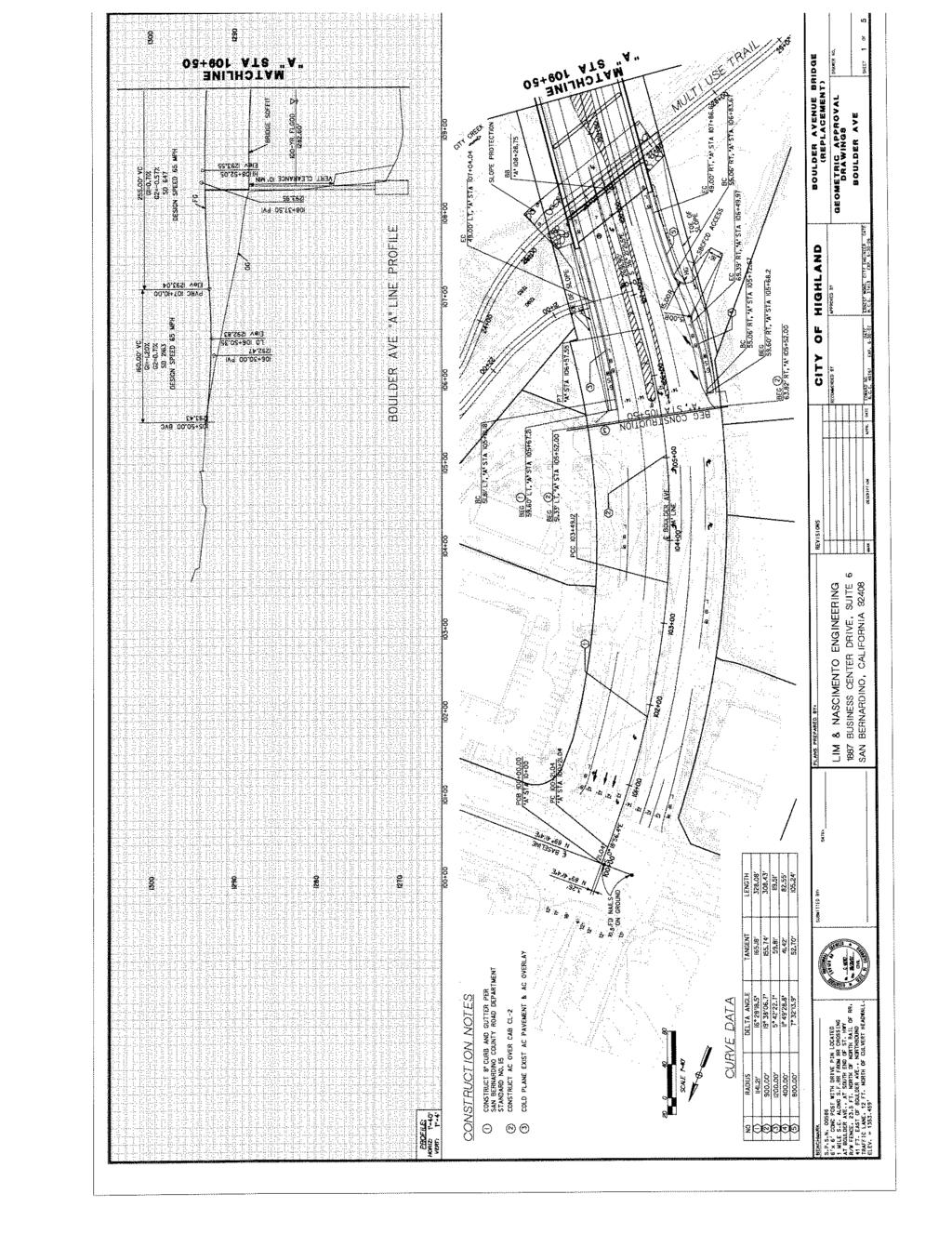
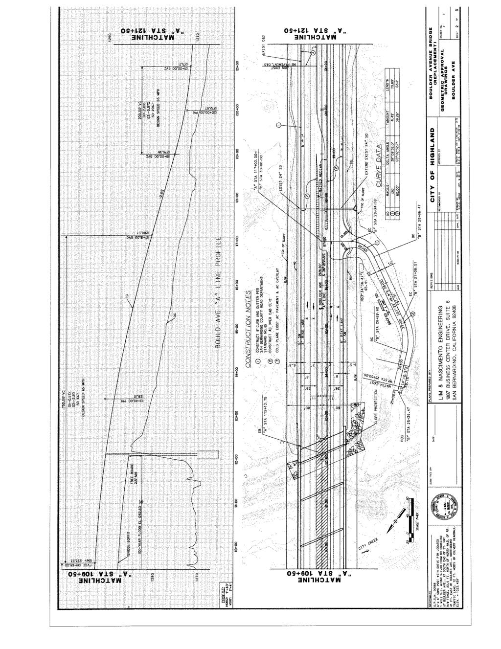
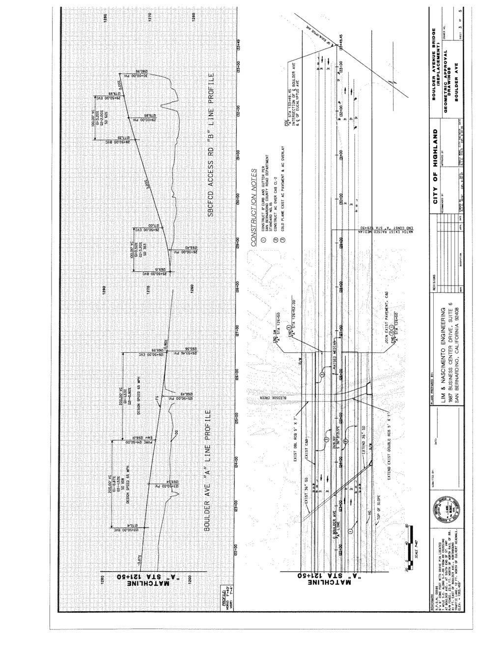
5 LSA ASSOCIATES, INC. AUGUST 2006 HIGHLAND, CALIFORNIA INTRODUCTION Project Description The City of Highland, in cooperation with the California Department of Transportation (Department) and the Federal Highway Administration (FHWA), proposes to improve the Boulder Avenue. The existing Boulder Avenue Bridge is a two (2) lane bridge over City Creek. The bridge has a Sufficiency Rating (SR) of 47.8 and has designated as structurally deficient. Local scour has been observed at Pier No. 6. and Caltrans has recommended performing bridge analysis to provide mitigations for the scouring issue. The roadway section approaching the bridge from both the north and the south is four (4) lane roadway, therefore this two lane bridge becomes a bottleneck for traffic. In order to resolve these problems with the existing bridge, the City of Highland intends to replace the existing two (2) lane Boulder Avenue Bridge with a four (4) lane bridge. The proposed action will include, but not be limited to, the following improvements: 1. Replace the Boulder Avenue Bridge over City Creek. The widened bridge will span 385 feet across City Creek and will be 110 feet wide. 2. Construct roadway approaches, approximately 190 feet to the north and 1,430 feet to the south, to tie into the existing four (4) lane roadway section. 3. Construction of street improvements include; utility construction, pavement widening, curbs, gutters, sidewalks, and decorative street lighting 4. Construct/modify the levee at the bridge abutment corners to protect the bridge abutments. 5. Improve the roadway to provide the clearance for multiuse-trail under the bridge, and the freeboard in accordance to the hydraulic analysis as required. 6. Extend two existing culverts, located approximately 600 feet and 1,000 feet from the south abutment, to accommodating four (4) lane roadway sections. 7. Extend Bledsoe Creek double-cell Reinforced Concrete Box (RCB). 8. Relocate/modify MWD overflow outlet, located adjacent to the Bledsoe Creek RCB if required. 9. Relocate utilities as needed. 10. Other miscellaneous improvements. Project Location and Access Boulder Avenue is a north-south arterial that traverses the City of Highland in San Bernardino County. The project extends from the north bank of the City Creek Wash on the north to Eucalyptus Avenue on the south (Figure 1). Land Use and Zoning The proposed project will widen the Boulder Avenue from two (2) lanes to four (4) lanes to tie into existing four (4) lane improvements before and after the project limits 200 feet north of the Boulder Avenue Bridge over City Creek to 1,400 feet south of the bridge. Existing land uses in the area of the proposed roadway widening and bridge replacement consist of undeveloped land on the east and west of proposed roadway improvements. Further to the northeast and east is residential development. R:\LIM532\PDF_LSA\IS\ Appendices\Appendix H Draft Traffic Study August 2006.doc (7/9/2007) 2
6 330 þ } CHURCH AVENUE Project Location BASELINE STREET ty BO Cr e ek 30 þ } DE UL Ci R EN AV UE 5TH STREET Regional Location Los Angeles County San Bernardino County! $ a " $ a "! ORANGE STREET $ % "! ( h & q?» A» A Project Area q? $ "! Riverside County $ a "! San t S N! Orange County A ( h & % 0 10 a An a R i ver 20 A Miles FIGURE 1 S N! 0 1,000 2,000 FEET METERS SOURCE: USGS 7.5' Quads: Redlands and Harrison Mtn. (1988), CA; Thomas Bros., R:\LIM532\G\Reports\Traffic\reg_loc.mxd (08/02/06) Boulder Avenue Bridge Replacement Traffic Study Regional and Project Location
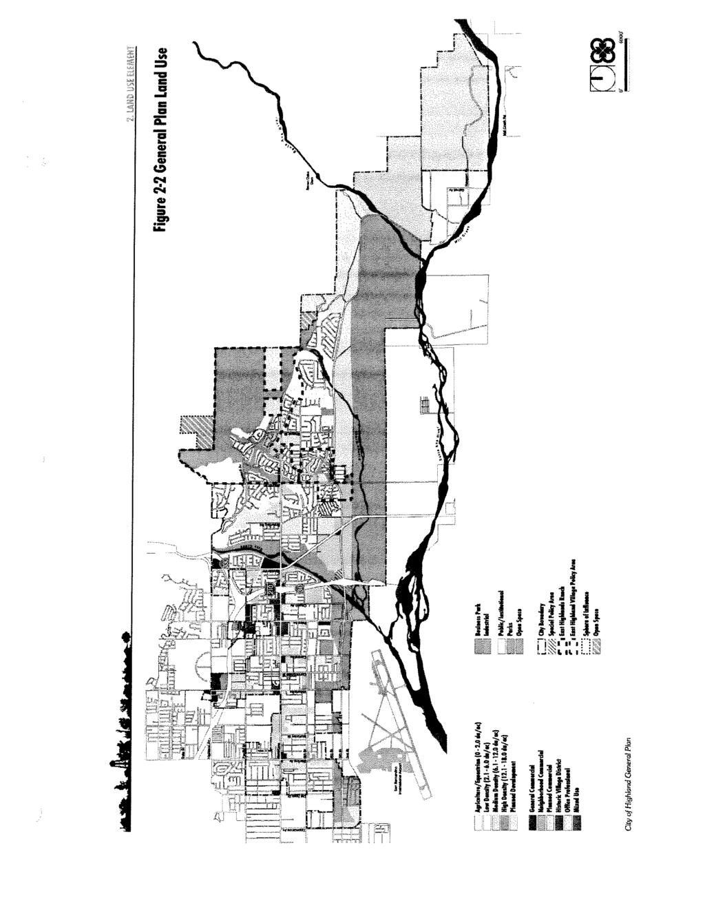
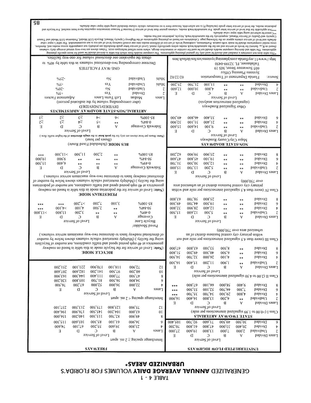
7 LSA ASSOCIATES, INC. AUGUST 2006 HIGHLAND, CALIFORNIA Farther to the south is a mixture of residential and commercial development with a new middle school built to the east of Boulder Avenue, south of Eucalyptus, outside of the project limits. On the west bank of City Creek, west of the bridge is a commercial storage facility and residential units. At the north end of the proposed improvements, south of Baseline Street, are new commercial developments that include a video store, fast food establishment and a pharmacy. The area is designated on the City s General Plan Map as open space and general commercial. The General Plan Land Use Map is provided in Appendix B. METHODOLOGY Performance Criteria According to San Bernardino County s Congestion Management Program (CMP) 2003 Update, the level of service (LOS) at an intersection or roadway is considered to be unsatisfactory when the volume-to-capacity ratio (V/C) exceeds 1.00 (LOS F). Therefore, for CMP purposes, LOS E is the standard for roadway operations. However, the CMP allows local jurisdictions to adopt a more stringent LOS standard, and the City of Highland has established LOS D as the applicable standard for this project. The relationship of V/C ratio to LOS is demonstrated in Table A. Table A Relationship between V/C Ratios and LOS Level of Service V/C Ratio Level of Service V/C Ratio A D B E C F > 1.00 The San Bernardino County CMP provides peak hour capacity tables based on the Quality/Level of Service Handbook published by the Florida Department of Transportation (FDOT); however, it does not provide daily capacity tables. Therefore, daily roadway capacities were determined using the FDOT Generalized Annual Average Daily Volumes for Florida s Urbanized Areas (Appendix C). The existing facility is classified as a Class II, two-lane, two-way undivided arterial. The proposed project will improve the roadway to a four-lane divided arterial. Table B demonstrates the theoretical daily capacities at LOS E for a two-lane undivided arterial and a four-lane divided arterial. Table B Daily Capacities for Roadways Class II 1 Facility Type Number of Lanes Capacity at LOS E Undivided 2 16,300 Divided 4 34,500 Source: Florida Department of Transportation (2002) 1 Class II is defined as having 2.00 to 4.50 signalized intersections per mile. R:\LIM532\PDF_LSA\IS\ Appendices\Appendix H Draft Traffic Study August 2006.doc (7/9/2007) 4
8 LSA ASSOCIATES, INC. AUGUST 2006 HIGHLAND, CALIFORNIA Development of Future Traffic Volumes Forecast 2030 ADT volumes were taken from the City of Highland General Plan Environmental Impact Report (hereinafter General Plan EIR ). Pages from the General Plan EIR showing daily traffic volumes are included in Appendix E. Year 2030 volumes were analyzed using the capacities of a two-lane undivided arterial (without project) and a four-lane divided arterial (with project). TRAFFIC ANALYSIS Existing Conditions Boulder Avenue through the project area is currently a two-lane, two-way undivided arterial with minimal development surrounding it. The adjacent segments of Boulder Avenue to the south and to the north are four-lane divided roadways. Year 2004 and year 2030 average daily traffic for the roadway segment of Boulder Avenue between Eucalyptus Avenue and Baseline Road were taken from the General Plan EIR. Pages from the General Plan EIR showing daily traffic volumes are included in Appendix D. Existing (2006) average daily traffic was developed based on growth between year 2004 conditions and forecast year 2030 conditions. For this purpose, linear growth between the 2004 conditions and the forecast 2030 conditions was assumed. Since the increment between 2004 and 2006 is 2 years of the 26-year time span, 2004 volumes were increased by 7.69 percent (i.e., 2/26) of the total growth from 2004 to 2030 to develop 2006 conditions. Existing daily traffic volumes, along with volume-to-capacity ratios and corresponding LOS, are listed in Table C. Table C Existing Daily Traffic Volume, Volume-to-Capacity Ratio, and LOS Roadway Segment Volume (ADT) Capacity V/C Ratio LOS Boulder Avenue from Eucalyptus Avenue to Base Line Road 6,630 16, A As Table C illustrates, the daily traffic volume on Boulder Avenue between Eucalyptus Avenue and Base Line Road is currently well below the theoretical capacity of the roadway per the Florida Department of Transportation. Year 2030 Traffic Conditions The daily traffic volumes, V/C ratios, and corresponding LOS for the roadway segment with and without widening are listed in Table D. Table D Year 2030 Daily Traffic Volumes, V/C Ratios, and LOS Roadway Segment Volume (ADT) Capacity V/C Ratio LOS Boulder Avenue Two lanes undivided 20,200 16, F Four lanes divided 20,200 34, A R:\LIM532\PDF_LSA\IS\ Appendices\Appendix H Draft Traffic Study August 2006.doc (7/9/2007) 5
9 LSA ASSOCIATES, INC. AUGUST 2006 HIGHLAND, CALIFORNIA As Table D illustrates, without the proposed project, the V/C ratio in the project area will exceed 1.0, resulting in operations at LOS F, which does not meet the City of Highland standard of LOS D. With the proposed project, the V/C ratio will be less than 0.60, resulting in operations at LOS A and maintaining the City s standard. CONCLUSION AND RECOMMENDATIONS Based on the analysis of forecast traffic volumes from the City of Highland General Plan EIR, implementation of the proposed widening of Boulder Avenue is necessary to maintain satisfactory traffic operations. R:\LIM532\PDF_LSA\IS\ Appendices\Appendix H Draft Traffic Study August 2006.doc (7/9/2007) 6
10 LSA ASSOCIATES, INC. AUGUST 2006 HIGHLAND, CALIFORNIA APPENDIX A CONCEPTUAL IMPROVEMENT PLANS R:\LIM532\PDF_LSA\IS\ Appendices\Appendix H Draft Traffic Study August 2006.doc (7/9/2007)
11
12
13
14

15
16 LSA ASSOCIATES, INC. AUGUST 2006 HIGHLAND, CALIFORNIA APPENDIX B GENERAL PLAN LAND USE MAP R:\LIM532\PDF_LSA\IS\ Appendices\Appendix H Draft Traffic Study August 2006.doc (7/9/2007)
17
18 LSA ASSOCIATES, INC. AUGUST 2006 HIGHLAND, CALIFORNIA APPENDIX C FLORIDA DEPARTMENT OF TRANSPORTATION CAPACITY TABLE R:\LIM532\PDF_LSA\IS\ Appendices\Appendix H Draft Traffic Study August 2006.doc (7/9/2007)
19
20 LSA ASSOCIATES, INC. AUGUST 2006 HIGHLAND, CALIFORNIA APPENDIX D EXISTING AVERAGE DAILY TRAFFIC R:\LIM532\PDF_LSA\IS\ Appendices\Appendix H Draft Traffic Study August 2006.doc (7/9/2007)
21
22 LSA ASSOCIATES, INC. AUGUST 2006 HIGHLAND, CALIFORNIA APPENDIX E PREFERRED GENERAL PLAN AVERAGE DAILY TRAFFIC R:\LIM532\PDF_LSA\IS\ Appendices\Appendix H Draft Traffic Study August 2006.doc (7/9/2007)
23
TABLE TRAFFIC ANALYSIS SCENARIOS
 4.11 TRANSPORTATION The potential traffic impacts of the proposed project are evaluated in the Buena Park Beach/Orangethorpe Mixed Use Project Traffic Analysis (Traffic Analysis) by Austin-Foust Associates
TABLE OF CONTENTS TABLE OF CONTENTS... I APPENDICES... III LIST OF EXHIBITS... V LIST OF TABLES... VII LIST OF ABBREVIATED TERMS...
 TABLE OF CONTENTS TABLE OF CONTENTS... I APPENDICES... III LIST OF EXHIBITS... V LIST OF TABLES... VII LIST OF ABBREVIATED TERMS... IX 1 INTRODUCTION... 1 1.1 Project Overview... 1 1.2 Analysis Scenarios...
APPENDIX G: INTERSECTION NEEDS AT OKEECHOBEE BOULEVARD
 APPENDIX G: INTERSECTION NEEDS AT OKEECHOBEE BOULEVARD INTERSECTION NEEDS AT SR 7 and OKEECHOBEE BOULEVARD SR 7 Extension Project Development and Environment (PD&E) Study From Okeechobee Boulevard (SR
Route 7 Corridor Study
 Route 7 Corridor Study Executive Summary Study Area The following report analyzes a segment of the Virginia State Route 7 corridor. The corridor study area, spanning over 5 miles in length, is a multi
Highway 111 Corridor Study
 Highway 111 Corridor Study June, 2009 LINCOLN CO. HWY 111 CORRIDOR STUDY Draft Study Tea, South Dakota Prepared for City of Tea Sioux Falls Metropolitan Planning Organization Prepared by HDR Engineering,
City of Wayzata Comprehensive Plan 2030 Transportation Chapter: Appendix A
 A1. Functional Classification Table A-1 illustrates the Metropolitan Council s detailed criteria established for the functional classification of roadways within the Twin Cities Metropolitan Area. Table
5.3 TRAFFIC, CIRCULATION AND PARKING
 5.3 TRAFFIC, CIRCULATION AND PARKING This section is based upon the Downtown Lancaster Specific Plan Traffic Impact Analysis (April 2, 2008) and the Downtown Lancaster Specific Plan Parking Analysis (May
CarMax Auto Superstore/ Reconditioning Center #6002 Murrieta, California
 CarMax Auto Superstore/ Reconditioning Center #6002 Murrieta, California TUSTIN 17782 17th Street Suite 200 Tustin, CA 92780-1947 714.665.4500 Fax: 714.665.4501 LOS ANGELES 145 S. Spring Street Suite 120
DRAFT. Corridor study. Honeysuckle Road. October Prepared for the City of Dothan, AL. Prepared by Gresham, Smith and Partners
 DRAFT Corridor study Honeysuckle Road October 2017 Prepared for the City of Dothan, AL Prepared by TABLE OF CONTENTS SECTION I... 1 STUDY SUMMARY... 1 INTRODUCTION... 1 CONCLUSIONS... 5 SECTION II... 7
4. ENVIRONMENTAL IMPACT ANALYSIS 9. TRANSPORTATION AND TRAFFIC
 4. ENVIRONMENTAL IMPACT ANALYSIS 9. TRANSPORTATION AND TRAFFIC 4.9.1 INTRODUCTION The following section addresses the Proposed Project s impact on transportation and traffic based on the Traffic Study
3.0 PROJECT DESCRIPTION
 The following section of the Draft EIR contains a description of the proposed Elk Grove Boulevard/SR 99 Interchange Modification project, consistent with the requirements of CEQA Guidelines Section 15124.
V. ENVIRONMENTAL IMPACT ANALYSIS K. TRANSPORTATION AND CIRCULATION
 V. ENVIRONMENTAL IMPACT ANALYSIS K. TRANSPORTATION AND CIRCULATION ENVIRONMENTAL SETTING The following section is based on the Draft Traffic Circulation Study for the Malibu La Paz Project (Traffic Study),
EAST AND SOUTH STREET CITY OF ANAHEIM, CALIFORNIA
 T R A F F I C I M P A C T A N A LY S I S EAST AND SOUTH STREET CITY OF ANAHEIM, CALIFORNIA April 217 T R A F F I C I M P A C T A N A LY S I S EAST AND SOUTH STREET CITY OF ANAHEIM, CALIFORNIA Submitted
Magnolia Place. Traffic Impact Analysis. Prepared for: City of San Mateo. Prepared by: Hexagon Transportation Consultants, Inc.
 Magnolia Place Traffic Impact Analysis Prepared for: City of San Mateo Prepared by: Hexagon Transportation Consultants, Inc. Updated January 4, 2010 Table of Contents 1. Introduction...1 2. Existing Conditions...6
Reams Road RCA Study. Board of County Commissioners Public Hearing
 Reams Road RCA Study Board of County Commissioners Public Hearing April 24, 2018 Presentation Overview Study Overview Existing Conditions Development of Alternatives Preferred Alternative Public Involvement
D.13 Transportation and Traffic
 This section addresses transportation and traffic issues and impacts related to the Proposed Project. Section D.13.1 provides a description of the affected environment for the Proposed Project. Applicable
Issue Paper on Transportation and Circulation
 Issue Paper on Transportation and Circulation General Plan Update Prepared by: Rincon Consultants, Inc. 1530 Monterey Street, Suite D San Luis Obispo, California 93401 July 2008 Table of Contents Introduction...
Abrams Associates. Transportation Impact Analysis. City of Rocklin. Prepared for: David Mohlenbrok City of Rocklin 4081 Alvis Court Rocklin, CA 95677
 Transportation Impact Analysis Sierra College Boulevard Commercial Project City of Rocklin Prepared for: David Mohlenbrok City of Rocklin 081 Alvis Court Rocklin, CA 95677 Prepared by: 1875 Olympic Boulevard,
WYDOT DESIGN GUIDES. Guide for. Non-NHS State Highways
 WYDOT DESIGN GUIDES Guide for Non-NHS State Highways 2014 GUIDE FOR Non-NATIONAL HIGHWAY SYSTEM (Non-NHS) STATE HIGHWAYS PRESERVATION REHABILITATION RECONSTRUCTION INTRODUCTION This Guide is directed to
Donahue Drive Corridor Traffic Operational Evaluation
 Donahue Drive Corridor Traffic Operational Evaluation PREPARED FOR: THE CITY OF AUBURN PREPARED BY: JANUARY 2007 Donahue Drive Corridor Study--Auburn, Alabama TABLE OF CONTENTS Introduction... 1 Background
Los Coyotes Country Club Development Plan Traffic Impact Analysis
 Los Coyotes Country Club Development Plan Traffic Impact Analysis Prepared For: Phil Martin Associates 2073007450 Los Coyotes Country Club Development Plan Traffic Impact Analysis June 19, 2014 Prepared
Highway 49, Highway 351 and Highway 91 Improvements Feasibility Study Craighead County
 Highway 49, Highway 351 and Highway 91 Improvements Feasibility Study Craighead County Executive Summary March 2015 Highway 49, Highway 351 and Highway 91 Improvements Feasibility Study Craighead County
Planning Committee STAFF REPORT March 7, 2018 Page 2 of 4 The following MTSOs are being used across the five subregions: Intersection Level of Service
 Planning Committee STAFF REPORT Meeting Date: March 7, 2018 Subject Summary of Issues Recommendations Financial Implications Options Attachments Changes from Committee Review Draft 2017 Multimodal Transportation
Bridge Street Corridor Study Report
 Bridge Street Corridor Study Report Prepared for: Prepared by: BRIDGE STREET CORRIDOR STUDY REPORT PREPARED FOR: CITY OF ARROYO GRANDE COMMUNITY DEVELOPMENT DEPARTMENT 300 EAST BRANCH STREET ARROYO GRANDE,
WYDOT DESIGN GUIDES. Guide for. NHS Arterial (Non-Interstate)
") WYDOT DESIGN GUIDES Guide for NHS Arterial (Non-Interstate) 2014 GUIDE FOR NATIONAL HIGHWAY SYSTEM (NHS) HIGHWAYS (NHS ARTERIALS, Non-Interstate) PRESERVATION REHABILITATION RECONSTRUCTION INTRODUCTION
WYDOT DESIGN GUIDES Guide for NHS Arterial (Non-Interstate) 2014 GUIDE FOR NATIONAL HIGHWAY SYSTEM (NHS) HIGHWAYS (NHS ARTERIALS, Non-Interstate) PRESERVATION REHABILITATION RECONSTRUCTION INTRODUCTION
3.9 - Transportation and Traffic
 Transportation and Traffic 3.9 - Transportation and Traffic This section describes the potential transportation and traffic effects of project implementation on the project site and its surrounding area.
4.11 TRANSPORTATION 4.11 TRANSPORTATION Environmental Setting Intersection, Roadway, and Freeway Evaluation Methodology
 4.11 TRANSPORTATION This section describes the road transportation system in the vicinity of the proposed Project and the potential impacts to this system from the proposed Project. The analysis in this
5.0 Roadway System Plan
 Southwest Boise Transportation Study Page 16 5.0 Roadway System Plan The Roadway System Plan outlines roadway improvements in the Initial Study Area. It forecasts future deficiencies on the arterial system,
4.4 TRAFFIC and CIRCULATION
 4.4 TRAFFIC and CIRCULATION This section analyzes potential impacts relating to traffic and circulation. The section summarizes the findings of a traffic impact study performed by Associated Transportation
Figure 1: East West Connector Alignment Alternatives Concept Drawing
 Page 2 of 9 Figure 1: East West Connector Alignment Alternatives Concept Drawing The Montebello Drive extension will run north south and connect Wilsonville Road to the Boones Ferry Road to Brown Road
Geometric Design Tables
 Design Manual Chapter 5 - Roadway Design 5C - Geometric Design Criteria 5C-1 Geometric Design Tables A. General The following sections present two sets of design criteria tables - Preferred Roadway Elements
Traffic Impact Statement
 Traffic Impact Statement Mixed Use Development, US 41 and Old Trail Drive aka Tide-Starbucks 4900 9 th Street North General Development Site Plan (GDSP) Collier County, FL 10/6/2015 Prepared for: Prepared
CITY OF OAKLAND. 27th Street Bikeway Feasibility and Design. Final Report (v3) March 23, Kimley-Horn and Associates, Inc.
 March 23, Kimley-Horn and Associates, Inc.") CITY OF OAKLAND 27th Street Bikeway Feasibility and Design Final Report (v3) March 23, 2007 PREPARED BY: Kimley-Horn and Associates, Inc. Table of Contents 1. Introduction 3 2. 27 th Street/Bay Place Corridor
CITY OF OAKLAND 27th Street Bikeway Feasibility and Design Final Report (v3) March 23, 2007 PREPARED BY: Kimley-Horn and Associates, Inc. Table of Contents 1. Introduction 3 2. 27 th Street/Bay Place Corridor
Clackamas County Comprehensive Plan
 ROADWAYS The County s road system permits the movement of goods and people between communities and regions, using any of a variety of modes of travel. Roads provide access to virtually all property. They
Non-Motorized Overpass at SR 5/US1
 Non-Motorized Overpass at SR 5/US1 And SR 97/SW th Street (Bird Road) Executive Summary March 9, 17 Prepared By: MARLIN Engineering Inc 17 NW th Avenue, Ste. 1 Plantation, FL 33313 P: 35.77.7575 www.marlinengineering.com
TRAFFIC IMPACT STUDY CRITERIA
 Chapter 6 - TRAFFIC IMPACT STUDY CRITERIA 6.1 GENERAL PROVISIONS 6.1.1. Purpose: The purpose of this document is to outline a standard format for preparing a traffic impact study in the City of Steamboat
City of Gainesville Transportation/Roadway Needs PROJECT SUMMARY
 A1 Roadway Resurfacing $23,846,000 TYPE: Preservation of existing system Roadway resurfacing A2 Signal Replacement $6,000,000 TYPE: Preservation of existing system Replace traffic signals. B1 W 6th St
4.10 TRANSPORTATION AND CIRCULATION
 4.10 TRANSPORTATION AND CIRCULATION PURPOSE The section discusses the potential impacts to traffic and circulation as a result of the implementation of the proposed Via Princessa East Extension, which
APPENDIX S REVISED PAGES OF THE SUPPLEMENTAL TRAFFIC IMPACT ANALYSIS
 APPENDIX S REVISED PAGES OF THE SUPPLEMENTAL TRAFFIC IMPACT ANALYSIS The capacity of the toll plaza was estimated based on data from numerous studies as well as traffic counts conducted at the toll plaza
JONESBORO HIGHWAY 63 HIGHWAY 18 CONNECTOR STUDY
 JONESBORO HIGHWAY 63 HIGHWAY 18 CONNECTOR STUDY Craighead County May 2007 JONESBORO HIGHWAY 63 HIGHWAY 18 CONNECTOR STUDY Craighead County May 2007 Prepared by Planning and Research Division Arkansas State
Clay Street Bridge Replacement Project
 Clay Street Bridge Replacement Project Frequently Asked Questions (FAQs) The project is located in downtown Placerville on Clay Street between US Highway 50 and Main Street and Cedar Ravine Road. The proposed
APPENDIX L: COST ESTIMATING TOOLS
 APPENDIX L: COST ESTIMATING TOOLS Rural Arterial From LRE MOT * Mobilization * Subtotal Scope Contingency (25%) Total PE Design (15%) CEI (15%) Total Project ** New (2-Lane Roadway) with 5' Paved Shoulders
Roadway Classification Design Standards and Policies. Pueblo, Colorado November, 2004
 Roadway Classification Design Standards and Policies Pueblo, Colorado November, 2004 Table of Contents Page Chapter 1. General Provisions 1.1 Jurisdiction 3 1.2 Purpose and Intent 3 1.3 Modification 3
TRAFFIC OPERATIONS ANALYSIS REPORT. Pacheco Boulevard Alignment Study and Alternatives Analysis
 TRAFFIC OPERATIONS ANALYSIS REPORT Pacheco Boulevard Alignment Study and Alternatives Analysis PREPARED FOR: CITY OF MARTINEZ AND CONTRA COSTA COUNTY OCTOBER 2016 FINAL REPORT Prepared By: under contract
 TRAFFIC IMPACT STUDY CANYON HILLS PROJECT LOS ANGELES, CALIFORNIA INTRODUCTION This traffic analysis has been conducted to identify and evaluate the potential traffic impacts of the proposed Canyon Hills
City of Homewood Transportation Plan
 City of Homewood Transportation Plan Prepared for: City of Homewood, Alabama Prepared by: Skipper Consulting, Inc. May 2007 TABLE OF CONTENTS INTRODUCTION... 1 BACKGROUND INFORMATION... 1 EXISTING TRANSPORTATION
Technical Advisory Committee (TAC)
") Technical Advisory Committee (TAC) January 17, 2018 CareerSource Heartland Sebring, FL 1) ROLL CALL 2) PUBLIC COMMENT 3) APPROVAL OF MINUTES* October 18, 2017 Meeting 4) SR 710 Extension in Okeechobee
Technical Advisory Committee (TAC) January 17, 2018 CareerSource Heartland Sebring, FL 1) ROLL CALL 2) PUBLIC COMMENT 3) APPROVAL OF MINUTES* October 18, 2017 Meeting 4) SR 710 Extension in Okeechobee
Transportation Impact Study for Abington Terrace
 Transportation Impact Study for Abington Terrace Abington Township, Montgomery County, PA Sandy A. Koza, P.E., PTOE PA PE License Number PE059911 Prepared by McMahon Associates, Inc. 425 Commerce Drive,
M-58 HIGHWAY ACCESS MANAGEMENT STUDY Mullen Road to Bel-Ray Boulevard. Prepared for CITY OF BELTON. May 2016
 M-58 HIGHWAY ACCESS MANAGEMENT STUDY Prepared for CITY OF BELTON By May 2016 Introduction Missouri State Highway 58 (M-58 Highway) is a major commercial corridor in the City of Belton. As development has
TRAFFIC ASSESSMENT River Edge Colorado
 TRAFFIC ASSESSMENT River Edge Colorado Submitted by: Fehr & Peers 621 17th Street, Ste. 231 Denver, CO 8293 (33) 296-43 December, 21 App. M-2 Traffic Assessment River Edge Colorado December 21 TABLE OF
TRAFFIC IMPACT ANALYSIS. Photo here CAL MET ROYAL MRF EXPANSION. City of Paramount, CA. arch beach C O N S U L T I N G.
 TRAFFIC IMPACT ANALYSIS z Photo here CAL MET ROYAL MRF EXPANSION City of Paramount, CA arch beach C O N S U L T I N G June 23, 214 TRAFFIC IMPACT ANALYSIS CAL MET ROYAL MATERIALS RECOVERY FACILITY (MRF)
3. Circulation Element
 3. Circulation Element This page intentionally left blank. Chapter 3. Circulation INTRODUCTION Purpose and Function A s development continues in the City of Highland, traffic on its roadway systems will
SELECTED ROADWAY CAPACITY ANALYSIS
 CHAPTERFOUR SELECTED ROADWAY CAPACITY ANALYSIS 4.1 SELECTED ROADWAY CAPACITY ANALYSIS Introduction Capacity analysis was performed on six selected roadways within the Dearborn County study area using the
CITY OF WOODINVILLE ONGOING CAPITAL IMPROVEMENT PROJECT UPDATES
 CITY OF WOODINVILLE ONGOING CAPITAL IMPROVEMENT PROJECT UPDATES PROJECT LOCATION MAP (1) DEYOUNG PARK IMPROVEMENTS Project Description - DeYoung Park Improvements include treehouse deck, play area, new
6.14 Traffic and Circulation
 6.14 Traffic and Circulation 6.14.1 Introduction The analysis in this section summarizes the findings and recommendations presented in the "Marywood Development Traffic Impact Study, City of Orange, California"
Executive Summary. North Florida Transportation Planning Organization Argyle Traffic Study
 North Florida Transportation Planning Organization i Executive Summary The Argyle Forest area is a highly congested transportation area located in southern Duval County. SR 9A (I-295) and SR 21 (Blanding
TRAFFIC IMPACT ANALYSIS
 TRAFFIC IMPACT ANALYSIS FOR THE CHAMPAIGN UNIT#4 SCHOOL DISTRICT PROPOSED HIGH SCHOOL (SPALDING PARK SITE) IN THE CITY OF CHAMPAIGN Final Report Champaign Urbana Urbanized Area Transportation Study 6/24/2014
CITY OF LOMITA CITY COUNCIL REPORT
 CITY OF LOMITA CITY COUNCIL REPORT TO: FROM: City Council Ryan Smoot, City Manager Item No. SCH 12 PREPARED BY: Mark A. McAvoy, P.E., Public Works Director/City Engineer MEETING DATE: August 1, 2017 SUBJECT:
Appendix T CCMP TRAIL TRAFFIC & TRANSPORTATION DESIGN STANDARD
 Appendix T CCMP 3.3.4 TRAIL TRAFFIC & TRANSPORTATION DESIGN STANDARD 3.3.4 Trail Traffic and Transportation Design Multi-use trails have certain design standards, which vary depending on the agency that
City of Memphis On-Street Parking Modification Guidelines
 City of Memphis Effective Date: December 1, 2013 Bicycle/Pedestrian Program 125 N. Main Street Memphis, TN 38103 (901) 576-6710 www.bikepedmemphis.com City of Memphis Executive Summary It is current practice
APPENDIXB. Traffic Operations Technical Memorandum
 APPENDIXB Traffic Operations Technical Memorandum Environmental Assessment - Lincoln County, SD 85 th Street: Sundowner Avenue to Louise Avenue November 2017 MEMORANDUM Transportation Jim Kollbaum, PE
Chapter 4: Funding and Implementation
 Chapter 4: Funding and Implementation 83 84 Cost Estimating Cost estimating is an iterative process. When a project is in the conceptual stage, preliminary cost estimates are also provided conceptually,
Lincoln Avenue Road Diet Trial
 Lincoln Avenue Road Diet Trial Data Collection Report June 1, 2015 Department of Transportation Table of Contents I. Introduction...... 3 II. Data Collection Methodology & Results...... 5 A. Traffic Volume
Walmart (Store # ) 60 th Street North and Marion Road Sioux Falls, South Dakota
 60 th Street North and Marion Road Sioux Falls, South Dakota") Walmart (Store #4865-00) 60 th Street North and Marion Road Sioux Falls, South Dakota Prepared for: Wal-Mart Stores, Inc. Bentonville, Arkansas Prepared by: Kimley-Horn and Associates, Inc. ã2013 Kimley-Horn
Walmart (Store #4865-00) 60 th Street North and Marion Road Sioux Falls, South Dakota Prepared for: Wal-Mart Stores, Inc. Bentonville, Arkansas Prepared by: Kimley-Horn and Associates, Inc. ã2013 Kimley-Horn
Clay Street Realignment Project Traffic Study
 Final Clay Street Realignment Project Traffic Study November 24, 2009 Prepared for: City of Placerville RS07-2466 2990 Lava Ridge Court, Suite 200 Roseville, CA 95661 (916) 773-1900 Fax (916) 773-2015
Brian McHugh, Buckhead Community Improvement District. SUBJECT: Wieuca Road at Phipps Boulevard Intersection Improvements Project
 MEMO TO: FROM: Brian McHugh, Buckhead Community Improvement District Jagan Kaja, AICP, WSP Parsons Brinckerhoff SUBJECT: Wieuca Road at Phipps Boulevard Intersection Improvements Project DATE: October
Glenn Avenue Corridor Traffic Operational Evaluation
 Glenn Avenue Corridor Traffic Operational Evaluation PREPARED FOR: THE CITY OF AUBURN PREPARED BY: DECEMBER 2007 Glenn Avenue Corridor Study--Auburn, Alabama TABLE OF CONTENTS Introduction... 1 Background
Public Information Meeting. Orange Camp Road. Dr. Martin Luther King Jr. Beltway to I-4. Presented by: Volusia County August 2, 2018
 Public Information Meeting Orange Camp Road Dr. Martin Luther King Jr. Beltway to I-4 Presented by: Volusia County August 2, 2018 1 Project Goals To improve the operations and safety for Orange Camp Road
Design Traffic Technical Memorandum
 State Road 7 Extension PD&E Study Design Traffic Technical Memorandum Palm Beach County, FL October 2010 State Road 7 Extension PD&E Study Design Traffic Technical Memorandum Palm Beach County, FL Prepared
APPENDIX D COST SUMMARY TABLES
 APPENDIX D COST SUMMARY TABLES Section 1 Between Route 50 and Evergreen Mills Road 3850 linear feet of one 12 foot wide additional lane in southbound direction of Rte 606; from north side of Rte 50 to
Prescott Plaza TRAFFIC IMPACT ANALYSIS TOWN OF YUCCA VALLEY
 Prescott Plaza TRAFFIC IMPACT ANALYSIS TOWN OF YUCCA VALLEY PREPARED BY: Aric Evatt, PTP aevatt@urbanxroads.com (949) 660-1994 x204 Charlene So, PE cso@urbanxroads.com (949) 660-1994 x222 OCTOBER 18, 2018
Project Description Form 8EE
 Project Description Form 8EE Basic Project Information Submitting Jurisdiction/Agency: Town of Dumfries Project Title: Route 1 (Fraley Blvd) Widening: Brady's Hill Road to Dumfries Road Project Location:
Road Conversion Study Plumas Street
 Plumas Street Phase I Submitted to The Regional Transportation Commission of Washoe County Submitted by Zong Tian, Ph.D., P.E. Saeedeh Farivar Haiyuan Li, Ph.D. Center for Advanced Transportation Education
BRIDGE REPLACEMENT AND REHABILITATION PROGRAM
 BRIDGE REPLACEMENT AND REHABILITATION PROGRAM INTRODUCTION An integral element of the City's transportation infrastructure is a network of bridges designed to carry vehicular, railroad, light rail, pedestrian,
INTRODUCTION THOROUGHFARE SYSTEM CLASSIFICATIONS
 INTRODUCTION The thoroughfare plan will assist public officials in the development of a specialized system for efficient and safe movement of vehicular traffic while minimizing potential conflicts with
B. TRANSPORTATION, CIRCULATION AND PARKING
 FEBRUARY 0 89 EL CAMINO REAL PROJECT EIR This section describes the existing traffic, circulation, parking, and transit conditions in the vicinity of the project site and provides an analysis of the project
4.11 TRANSPORTATION/CIRCULATION
 4.11 TRANSPORTATION/CIRCULATION This section was developed using information from a Traffic Analysis Report prepared for the project by OEG, Inc. (2010), the Paradiso del Mare Ocean and Inland Estates
TRAFFIC STUDY GUIDELINES Clarksville Street Department
 TRAFFIC STUDY GUIDELINES Clarksville Street Department 9/1/2009 Introduction Traffic studies are used to help the city determine potential impacts to the operation of the surrounding roadway network. Two
NOTICE OF AVAILABILITY/NOTICE OF COMMENT PERIOD OF A DRAFT EIR/EIS/EIS FOR PUBLIC REVIEW AND HEARINGS
 Tahoe Transportation District 128 Market Street, Suite 3F Stateline, NV 89449 Phone: (775) 589-5500 www.tahoetransportation.org Federal Highway Administration 650 Capitol Mall, Suite 4-100 Sacramento,
Section 3.14 Transportation and Traffic
 Section 3.14 Transportation and Traffic 3.14.1 Introduction The analysis contained in this section is based on the results of the TIA prepared by Fehr and Peers, dated March 2017, and included in Appendix
Lyons Avenue/Dockweiler Road Extension Project Draft Environmental Impact Report. Appendix I Traffic Impact Study
 Lyons Avenue/Dockweiler Road Extension Project Draft Environmental Impact Report Appendix I Traffic Impact Study Street 0 80-1947 500.4501 RITA ld Court 0 91355-1096 400.7401 LA n Avenue 0 590-3745 300-9301
3.0 Future Conditions
 3.0 Future Conditions In order to be able to recommend appropriate improvements to the transportation system of the Town, it is important to first understand the nature and volume of traffic that is expected
LANE ELIMINATION PROJECTS
 PRESENTATION OUTLINE Lane Elimination Considerations Districts 4 & 7 Draft Lane Elimination Processes FDOT Lane Elimination Guidelines Example Projects D4 Case Study: SR A1A (Ft. Lauderdale) D7 Case Study:
Angie Silva Kitsap County Commissioners Office Stef Herzstein, PE, PTOE Transpo Group Jessica Lambert Transpo Group
 DRAFT MEMORANDUM Date: September 30, 2016 TG: 16125.00 To: From: cc: Subject: Angie Silva Kitsap County Commissioners Office Stef Herzstein, PE, PTOE Transpo Group Jessica Lambert Transpo Group Erik Rundell
3.16 TRANSPORTATION, CIRCULATION, AND PARKING Regulatory Setting Environmental Setting ROADWAY SYSTEM
 3.16 TRANSPORTATION, CIRCULATION, AND PARKING This section assesses the potential for implementation of the Orchard Park Redevelopment component of the 2018 LRDP to result in impacts related to transportation,
Board of Supervisors February 27, 2017
 : Traffic Analysis Results & Draft Conceptual Plan Board of Supervisors February 27, 2017 Transportation Solutions Building Better Communities Presentation Overview Background Summary of Traffic Analysis
7.0 FREEWAYS CONGESTION HOT SPOT PROBLEM & IMPROVEMENT PROJECT ANALYSIS & DEFINITION
 7.0 FREEWAYS CONGESTION HOT SPOT PROBLEM & IMPROVEMENT PROJECT ANALYSIS & DEFINITION 7.1 INTRODUCTION & METHODOLOGY FEASIBILITY REPORT Congestion hot spot problem locations have been assessed using the
CHAPTER 4: IDENTIFICATION OF ROAD SYSTEM DEFICIENCIES: TRANSPORTATION PLANNING MODEL
 CHAPTER 4: IDENTIFICATION OF ROAD SYSTEM DEFICIENCIES: TRANSPORTATION PLANNING MODEL I. INTRODUCTION Transportation planning models are the primary tools used to predict future travel conditions. With
5.16 TRAFFIC AND CIRCULATION
 5.16 TRAFFIC AND CIRCULATION This section is based upon the Tierra Robles Traffic Impact Study (May 2015) and Supplemental Traffic Impact Analysis (August 2017) prepared by Omni-Means Engineering Solutions,
ACCESS MANAGEMENT STANDARDS FOR COUNTY ROADS ON THE THOROUGHFARE RIGHT OF WAY IDENTIFICATION MAP
 ACCESS MANAGEMENT STANDARDS FOR COUNTY ROADS ON THE THOROUGHFARE RIGHT OF WAY IDENTIFICATION MAP PRODUCED BY: PALM BEACH COUNTY ENGINEERING AND PUBLIC WORKS DEPARTMENT October 2004 Updated September 2016
Appendix B. Transportation Analysis. B.1 Summary. East Nassau Employment Center DSAP
 Appendix B Transportation Analysis B.1 Summary This report presents the transportation analysis completed for the East Nassau Community Planning Area (ENCPA). The ENCPA is defined as 24,000 acres in Nassau
3.13 TRANSPORTATION AND TRAFFIC
 3.13 TRANSPORTATION AND TRAFFIC INTRODUCTION This section of the Draft EIR describes the transportation and traffic based on the Transportation Impact Analysis (TIA) prepared by Overland Traffic Consultants,
Subject: Solberg Avenue / I-229 Grade Separation: Traffic Analysis
 MEMORANDUM Transportation Bill Troe, AICP Jason Carbee, AICP 12120 Shamrock Plaza Suite 300 Omaha, NE 68154 (402) 334-8181 (402) 334-1984 (Fax) To: Project File Date: Subject: Solberg Avenue / I-229 Grade
1609 E. FRANKLIN STREET HOTEL TRAFFIC IMPACT STUDY EXECUTIVE SUMMARY
 1609 E. FRANKLIN STREET HOTEL TRAFFIC IMPACT STUDY EXECUTIVE SUMMARY Prepared for: The Town of Chapel Hill Public Works Department Traffic Engineering Division Prepared by: HNTB North Carolina, PC 343
2014 STATE OF THE SYSTEM REPORT
 2014 STATE OF THE SYSTEM REPORT March 2016 This page intentionally left blank System Performance Monitoring This page intentionally left blank System Performance Monitoring State of the System Performance
ALLEY 24 TRAFFIC STUDY
 ALLEY 24 TRAFFIC STUDY in City of Frostburg, Maryland January 2013 3566 Teays Valley Road Hurricane, WV Office: (304) 397-5508 www.denniscorporation.com Alley 24 Traffic Study January 2013 Frostburg, Maryland
MEMORANDUM. To: 1.0 PURPOSE
 MEMORANDUM To: Scott Holland, Elements Architecture From: Brian Grover, Dudek Date: July 16, 2014 1.0 PURPOSE In response to the November 4, 2013 request (RE: Incomplete Application Southern California
Intersection Traffic Control Feasibility Study
 Intersection Traffic Control Feasibility Study CSAH 9 at CSAH 60 (185th Avenue) Prepared For: Dakota County Transportation Department Western Service Center 14955 Galaxie Avenue, 3rd Floor Apple Valley,
Task Force Meeting #5, August 3, Prepared by DKS Associates
 Task Force Meeting #5, August 3, 2018 Prepared by DKS Associates Agenda 1. Agenda Review and Meeting #4 Recap 2. Review Project Goal, Data, and Project Ideas 3. Recommendations and Reporting a) Recommended
Traffic Impact Study. Westlake Elementary School Westlake, Ohio. TMS Engineers, Inc. June 5, 2017
 TMS Engineers, Inc. Traffic Impact Study Westlake Elementary School Westlake, Ohio June 5, 2017 Prepared for: Westlake City Schools - Board of Education 27200 Hilliard Boulevard Westlake, OH 44145 TRAFFIC