BUS RAPID TRANSIT. A Canadian Perspective. McCormick Rankin International. John Bonsall P.Eng
|
|
|
- Carol Mitchell
- 6 years ago
- Views:
Transcription
1 BUS RAPID TRANSIT A Canadian Perspective

2 Why choose BRT? Because it is a practical and cost effective rapid transit solution for the most common types of land use in urban Canada
3 Operating experience shows that BRT is appropriate because It can serve low density land uses while at the same time encouraging nodal development It offers a region wide high quality cost effective service at an early stage but with infrastructure that can be staged to keep pace with development It delivers social benefits by reducing the number of car based trips and by increasing mobility
4 There are several existing and planned BRT systems in Canada Ottawa was the first and is still the largest BRT system
5 There are several existing and planned BRT systems in Canada There are also operating BRT systems in Quebec City, Montréal, York and Vancouver
6 There are several existing and planned BRT systems in Canada and several more systems in various stages of planning

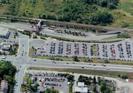
7 This presentation will feature the BRT systems in Ottawa, Vancouver and the planned system in Toronto Vancouver Ottawa Toronto
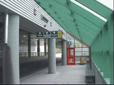
8 The Ottawa Process Began with a 1974 Official Plan based on a transit first philosophy Followed by planning studies in the late 1970s that recommend a BRT solution First permanent busway sections opened in 1983 Now comprises a 60km system with 32 stations and a variety of different types of running way serving a population of 735,000
9 The planning was based on an integrated land use and transportation approach It used transit mode share targets to define an overall strategy and service plan LEGEND : 1971 POLICY 24 30

10 The 60km system comprises a range of different running ways
11 The service on these running ways combines line haul service just like LRT Line haul routes Feeder routes P&R P&R P&R with routes that reduce the need to transfer P&R


12 Supplemented with real time service control and public information.

13 The service effectiveness of this operating strategy is demonstrated by the mode share outcomes in Ottawa and an annual patronage of 120 linked trips per capita and a daily busway patronage of 200,000 LEGEND : POLICY


14 Low density suburbs are quite compatible with BRT


15 But by combining the BRT service plan with stations.
 BRT Station Busway")
16 the results were also new mixed use nodal development in older neighborhoods New mixed Use Development Residential Government Office Complex ) BRT Station Busway

17 new shopping centres and business parks in new suburbs. Shopping Center Business Park Station Busway Ped Overpass Business Park Ped Link


18 shopping mall intensification in older suburbs s suburban mall BRT Arrives Initial New Development The Mall Today

19 air rights development over BRT.. Station Hospital Busway

20 Apartments & Townhouses School Stations Apartments..and linear corridor intensification Hospital Busway


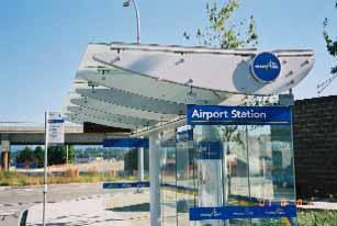
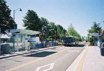
21 The Ottawa approached also demonstrated that BRT infrastructure costs can be deferred without delaying service introduction because The BRT vehicle can run in its own guideway or on-street


22 This means.. a region-wide BRT service plan was implement initially using low cost infrastructure as the running ways and stations....and transitioned over time to a fully exclusive busway and major stations
23 This meant that BRT implementation could keep pace with development growth Stage 1 Arterial Bus Lanes Mixed Flow Busway Freeway Shoulder Lanes
24 This meant that BRT implementation could keep pace with development growth Stage 2 Arterial Bus Lanes Mixed Flow Busway Freeway Shoulder Lanes
25 This meant that BRT implementation could keep pace with development growth Stage 3 Arterial Bus Lanes Mixed Flow Busway Freeway Shoulder Lanes
26 This meant that BRT implementation could keep pace with development growth Stage 4 Arterial Bus Lanes Mixed Flow Busway Freeway Shoulder Lanes

27 The infrastructure cost of the 60km system was $460 million Arterial Bus Lanes Mixed Flow Busway Freeway Shoulder Lanes
28 This rapid transit system cost less to build and operate as BRT than as LRT Ottawa BRT Grade Separated $12.3 to $26.0m/km Freeway Shoulder $2.6m/km North American LRT (average costs) At grade construction $16.5m/km Grade separated construction $40 m/km Pittsburgh BRT and LRT Per operating passenger costs 40% less for BRT

29 In Vancouver BRT is a permanent corridor mode and a precursor for rail and there are three corridors in operation providing 40 km of service BRT B-Line ICTS Skytrain Future ICTS

30 The primary service is the 98B from Vancouver to Richmond Seymour It is a 16km line-haul in-street service with sections of: and median busway Curb bus lanes

31 The Service Design High frequency All day service Limited stops Simple route
32 The BRT infrastructure includes: Unique Shelters Median Busway Bus Lanes


33 Other priority measures include: Signal pre-emption Queue jumpers Traffic signal priority Transponder Roadside Receivers Traffic Signal Controller Interface

34 Automated Vehicle Location (AVL) Monitors position using GPS Real time station displays show arrival times Linked to schedule adherence for real time traffic signal priority

35 Vehicles Distinctive, visible Easy to board/ alight High capacity
36 Costs and Benefits Capital Costs - $52 million Vehicles - $18.0 million Infrastructure $29.2 million Service Management System $4.6 million Benefits Annual net benefit of $2.9 million 23% mode shift from the car Patronage increase of 1.2 million riders per year
37 In Toronto BRT will complement a multi-modal network Arterial BRT Toronto High speed BRT Commuter Rail Subway

38 At build out 76% of the 100 km BRT Spine Line will be grade separated Busway


39 .6% will be at grade arterial busway either guided or unguided


40 and 15% will be some form of bus lane leaving only about 4% of the line as mixed flow operations


41 Direct bus only ramps linking the busway with the intersecting 400 series highways used by transit are proposed


42 There will be 45 stations of various configurations and 5000 park and ride spaces

43 In addition to the terminal stations at Oakville and Pickering, three of the stations will at existing GO Rail stations with opportunities for four more BRT/Rail interchanges as new GO services are implemented

44 By 2011 this 100 km system could be carrying as many as 200,000 riders per day A fully functional 100 km Spine Line and TTC Connecting Link system can be completed for $965 million including $120 million for additional buses. At its peak load point, the BRT will carry as many people as a six lane highway
45 This Canadian experience shows that BRT can.serve suburban land uses effectively.be a catalyst for land use intensification.be staged to keep pace with development.be built and operated at less cost than rail.attract former car drivers and improve accessibility
46 But in the end just.. Give BRT a chance Thank you
2.2 TRANSIT VISION 2040 FROM VISION TO ACTION. Emphasize transit priority solutions STRATEGIC DIRECTION
 TRANSIT VISION 2040 FROM VISION TO ACTION TRANSIT VISION 2040 defines a future in which public transit maximizes its contribution to quality of life with benefits that support a vibrant and equitable society,
Roadways. Roadways III.
 Introduction 97 Roadway Design Principles 98 Safe Speeds 99 Optimizing of Street Space 00 Minimum Lane Widths in the City of Boston 02 Design Features that Reduce Operating Speeds 05 Travel Lanes Transit
Southwest Bus Rapid Transit (SW BRT) Functional Planning Study - Executive Summary January 19 LPT ATTACHMENT 2.
 Functional Planning Study - Executive Summary January 19 LPT ATTACHMENT 2.") Southwest Bus Rapid Transit (SW BRT) Functional Planning Study - Executive Summary 2011 January 19 1 of 19 Introduction This executive summary presents the results of the Southwest Bus Rapid Transit (SW
Southwest Bus Rapid Transit (SW BRT) Functional Planning Study - Executive Summary 2011 January 19 1 of 19 Introduction This executive summary presents the results of the Southwest Bus Rapid Transit (SW
5. RUNNINGWAY GUIDELINES
 5. RUNNINGWAY GUIDELINES These guidelines should be considered collectively when making runningway decisions. A runningway is the linear component of the transit system that forms the right-of-way reserved
PURPOSE AND NEED SUMMARY 54% Corridor Need 1. Corridor Need 2. Corridor Need 3. Corridor Need 4. Corridor Need 5
 SUMMARY PURPOSE AND NEED Chapel Hill Transit ridership has increased Buses operate every 4 minutes and have standing room only Exceeding seated capacity by 12% Corridor Need 1 by more than 20 percent between
Executive Summary BEYOND THE B-LINE: RAPID TRANSIT LINE PHASE II - COMMERCIAL DRIVE WEST. Final Draft December 13, Appendix B BROADWAY/LOUGHEED
 BEYOND THE B-LINE: BROADWAY/LOUGHEED RAPID TRANSIT LINE PHASE II - COMMERCIAL DRIVE WEST Appendix B Executive Summary Final Draft December 13, 1999 UMA Lloyd Lindley Davidson Yuen Simpson Architects BROADWAY/LOUGHEED
Markham Sports, Entertainment and Cultural Centre Transportation Overview
 Markham Sports, Entertainment and Cultural Centre Transportation Overview ARENA LOCATION 2 3 TRANSPORTATION VISION IN MARKHAM On April 12, 2011, Markham Council adopted a long-term Transportation Vision
Bus Rapid Transit Plans
 Twin Cities Region Bus Rapid Transit Plans ULI Minnesota Workshop Connecting Bus Rapid Transit to the Community December 15, 2009 John Levin Director of Service Development Metro Transit Metropolitan Area
NEWMARKET CENTRE Mobility Hub Profile
 Mobility Hub Profile Dundas Newmarket West-Bloor Centre Anchor Hub Gateway Hub N MOBILITY HUBS: Places of connectivity between regional and rapid transit services, where different modes of transportation
Prepared For: Shieldbay Developments Inc. c/o Matson, McConnell Ltd. 2430A Bloor Street West Toronto, Ontario M6S 1P9.
 Prepared For: Shieldbay Developments Inc. c/o Matson, McConnell Ltd. 2430A Bloor Street West Toronto, Ontario M6S 1P9 Prepared By: URS Canada Inc. 4 th Floor, 30 Leek Crescent Richmond Hill, Ontario L4B
DON MILLS-EGLINTON Mobility Hub Profile
 Mobility Hub Profile Dundas Don Mills-Eglinton West-Bloor Anchor Hub Gateway Hub N MOBILITY HUBS: Places of connectivity between regional and rapid transit services, where different modes of transportation
State Road 54/56 Tampa Bay s Northern Loop. The Managed Lane Solution Linking I-75 to the Suncoast Parkway
 State Road 54/56 Tampa Bay s Northern Loop The Managed Lane Solution Linking I-75 to the Suncoast Parkway SUNCOAST PARKWAY Both I 75 and the Suncoast Parkway are planning, or in the process of constructing,
DON MILLS-SHEPPARD Mobility Hub Profile
 DON MILLS-SHEPPARD Mobility Hub Profile Dundas Don Mills-Sheppard West-Bloor Anchor Hub Gateway Hub N MOBILITY HUBS: Places of connectivity between regional and rapid transit services, where different
Highway Transitway Corridor Study
 Highway Transitway Corridor Study CTS Research Conference May 21, 2014 1 2030 Transportation Policy Plan Transitway modes on highways: Highway bus rapid transit (BRT), plan identified 6 total Highway BRT
Building a Liveable Ottawa 2031 Backgrounder 4: Kanata/Stittsville
 Building a Liveable Ottawa 2031 Backgrounder 4: Kanata/Stittsville Wards 4, 6 and 23 Official Plan Transportation Master Plan Cycling Plan Pedestrian Plan October 2013 ottawa.ca/liveableottawa Building
STATION #3 INITIAL ALTERNATIVES
 www.dot.il.gov www.eisenhowerexpressway.com STATIO #3 IHB RR Heavy Rail Transit (HRT) High capacity transit mode serving urban areas:» Steel wheeled, high performance electric powered rail vehicles» Right-of-way
Interim Transit Ridership Forecast Results Technical Memorandum
 Interim Transit Ridership 401 South Jackson Street Seattle, WA 98104-2826 September 2012 Table of Contents 1 INTRODUCTION... 1-1 1.1 Project Background... 1-1 2 RIDERSHIP FORECASTS... 2-1 2.1 System Ridership
WHAT IS BRT? Jack M. Gonsalves, PE, Parsons Brinckerhoff, Inc. February 22, 2012
 WHAT IS BRT? Jack M. Gonsalves, PE, Parsons Brinckerhoff, Inc. February 22, 2012 What is Bus Rapid Transit (BRT)? A flexible, high performance rapid transit mode that combines a variety of physical, operating,
Transit Priority Program: Putting Buses First
 Case Studies in Sustainable Transportation OTTAWA, ONTARIO CASE STUDY 1 Transit Priority Program: Putting Buses First Organization City of Ottawa Transportation, Utilities and Public Works Department Status
Wellington Public Transport Spine Study
 Wellington Public Transport Spine Study Study purpose Feasibility study Options for a high quality, high frequency PT system Key action from Ngauranga to Airport Corridor Plan (2008) Long-term outlook
Access BART: TOD and Improved Connections. October 29, 2008
 Access BART: TOD and Improved Connections October 29, 2008 1 Access BART Study Goals Evaluate at the system-level land use and access scenarios to optimize ridership Identify station clusters that provide
Chapter 2 Current and Future Conditions
 Chapter 2 Current and Future Conditions 2.1 An Overview of Ottawa s Transportation System The City of Ottawa is home to about 870,700 people. The city covers an area of 2,760 square kilometres of which
4 DISRUPTION MANAGEMENT PLAN HIGHWAY 7 RAPIDWAY CONSTRUCTION BETWEEN BAYVIEW AVENUE AND WARDEN AVENUE TOWNS OF MARKHAM AND RICHMOND HILL
 4 DISRUPTION MANAGEMENT PLAN HIGHWAY 7 RAPIDWAY CONSTRUCTION BETWEEN BAYVIEW AVENUE AND WARDEN AVENUE TOWNS OF MARKHAM AND RICHMOND HILL The Transportation Services Committee recommends the adoption of
METRO RTA TRANSIT MASTER PLAN. May 25-26, 2011
 METRO RTA TRANSIT MASTER PLAN May 25-26, 2011 WHAT IS THE TRANSIT MASTER PLAN? A twenty-year plan for METRO RTA What will METRO look like in 2031? 1 TRANSIT TECHNOLOGIES 2 TRANSIT TECHNOLOGIES Transit
Durham Region Long Term Transit Strategy
 Durham Region Long Term Transit Strategy An adaptive, safe, reliable, frequent, accessible and desirable transit system that shapes and connects Durham Region and beyond in an economically and environmentally
WHITE PAPER: TRANSIT SERVICE FOR SOUTH SHAGANAPPI
 9/27/2012 TRANSIT PLANNING WHITE PAPER: TRANSIT SERVICE FOR SOUTH SHAGANAPPI 2012 Calgary Transit 1 Table of Contents Purpose... 3 Area of Change... 3 Background... 3 Access to destinations... 5 Connecting
Transportation Master Plan Advisory Task Force
 Transportation Master Plan Advisory Task Force Network Alternatives & Phasing Strategy February 2016 BACKGROUND Table of Contents BACKGROUND Purpose & Introduction 2 Linking the TMP to Key Council Approved
David Jickling, Public Transportation Director Regional Transportation Commission, Washoe County
 David Jickling, Public Transportation Director Regional Transportation Commission, Washoe County Virginia Street Resort corridor connecting University of Nevada, Reno Downtown Truckee River Strip Casinos
July 23, Transit Workshop
 Agenda 1. Introductions 2. Presentation: Public Transit in Regina Review of Practices Elsewhere 3. Discussion #1: Transit Today 4. Break 5. Discussion #2: Transit Tomorrow Corridors, Service, and Amenities
Corporate. Report COUNCIL DATE: June 26, 2006 NO: C012 COUNCIL-IN-COMMITTEE. TO: Mayor & Council DATE: June 22, 2006
 Corporate NO: C012 Report COUNCIL DATE: June 26, 2006 COUNCIL-IN-COMMITTEE TO: Mayor & Council DATE: June 22, 2006 FROM: General Manager, Engineering FILE: 0410-20(MoT/Gate) SUBJECT: Surrey Response on
Peterborough Council on Aging
 Peterborough Council on Aging Discussion paper series #4, 2015 Transportation Transportation, including accessible and affordable public transport is a key factor influencing active aging. in particular,
York Region Population and Employment Growth
 March 1, 2016 1 York Region Population and Employment Growth York Region needs to comply with The Provincial Growth Plan and new forecasts introduced to 2036 and 2041 2 Regional Official Plan Review York
DUNDAS WEST-BLOOR Mobility Hub Profile
 Mobility Hub Profile Dundas West-Bloor Anchor Hub Gateway Hub N MOBILITY HUBS: Places of connectivity between regional and rapid transit services, where different modes of transportation come together
Purpose and Need. Chapter Introduction. 2.2 Project Purpose and Need Project Purpose Project Need
 Chapter 2 Purpose and Need 2.1 Introduction The El Camino Real Bus Rapid Transit (BRT) Project (Project) would make transit and other transportation improvements along a 17.6-mile segment of the El Camino
NORTH YORK CENTRE Mobility Hub Profile
 Mobility Hub Profile Dundas North York West-Bloor Centre Anchor Hub Gateway Hub N MOBILITY HUBS: Places of connectivity between regional and rapid transit services, where different modes of transportation
Appendix A-K Public Information Centre 2 Materials
 Appendix A-K Public Information Centre 2 Materials Our Rapid Transit Initiative Make an impact on the future of transit Join the discussion on Rapid Transit in London You re invited to a Public Information
TRANSIT SIGNAL PRIORITY The Toronto Experience
 TRANSIT SIGNAL PRIORITY The Toronto Experience July 27, 2004 July 27, 2004 1 Warning This presentation contains graphic images depicting serious violations to the coordination of traffic signals and may
Afeasibility study to evaluate bus rapid transit service in the East-West Corridor connecting major employment and activity centers between downtown
 East-West Bus Rapid Transit Feasibility Study Update and Recommended Locally Preferred Alternative (LPA) Summary City of Wauwatosa, Transportation Affairs Committee June 2016 Afeasibility study to evaluate
VOLUME 5 Technology and Option Evaluation
 VICTORIA REGIONAL RAPID TRANSIT Victoria / West Shore Link VOLUME 5 Technology and Option Evaluation August 2011 Prepared for BC Transit by SNC-Lavalin Inc McElhanney Consulting Services Ltd Errata 1.
2. Corridor Analysis. Transit Oriented Development. KAT Transit Development Plan. Corridor Analysis CORRADINO. Figure 2-1 Typical Components of TOD
 2. The purpose of this task is to identify transportation corridors in the Knoxville Area that are most suitable for the implementation of possible fixed-guideway, high capacity (rail or bus rapid transit)
In station areas, new pedestrian links can increase network connectivity and provide direct access to stations.
 The Last Mile Planning for Pedestrians Planning around stations will put pedestrians first. Making walking to stations safe and easy is important; walking will be a part of every rapid transit Accessible
Highway Engineering, second edition: Martin Rogers 2008 by Blackwell Publishing Ltd
 Question 2.1 Office workers within a residential development have a choice of the following work destinations: Urban Centre A, 150 minutes travel time away, with 7 million m 2 of office space Urban Centre
Regional Transportation Needs Within Southeastern Wisconsin
 Regional Transportation Needs Within Southeastern Wisconsin #118274 May 24, 2006 1 Introduction The Southeastern Wisconsin Regional Planning Commission (SEWRPC) is the official areawide planning agency
Welcome to the McKenzie Interchange Project Open House!
 Welcome to the McKenzie Interchange Project Open House! Purpose of Open House To provide you with information regarding the project and for you to have the opportunity to share your input on design concepts.
Previous Transit Studies MTTF MEETING #
 Previous Transit Studies MTTF MEETING #4 2013-03-22 Agenda Project timeline Final transit recommendation (2011) Transit planning and development (2002 2011) Moving forward (2011 2013) 2 Project Timeline
Sixth Line Development - Transit Facilities Plan
 Memorandum Date: November 13, 2012 To: From: c.c. Subject: Rob Freeman (Freeman Planning) Kevin Phillips Sixth Line Development - Transit Facilities Plan 33016631 This memo was prepared to review the transit
Multimodal Approach to Planning & Implementation of Transit Signal Priority within Montgomery County Maryland
 Multimodal Approach to Planning & Implementation of Transit Signal Priority within Montgomery County Maryland A Path to Successful Implementation James Allday Bunch - Sabra, Wang & Associates, Inc. ITS
Scope of the Transit Priority Project
 Transit Planning Committee #1 March 19, 2015 Scope of the Transit Priority Project Review of the 2010 plan Analysis of Transit Priority Measures Preliminary plans for rapid transit Recommendations for
Appendix C. NORTH METRO STATION AREA TRAFFIC IMPACT STATEMENT 88th Avenue Station
 Appendix C NORTH METRO STATION AREA TRAFFIC IMPACT STATEMENT 88th Avenue Station Prepared for: Regional Transportation Department and URS Corporation as part of the North Metro EIS David Evans and Associates,
Frequently Asked Questions (FAQ)
") Frequently Asked s (FAQ) Study Process... 2 Rapid Transit Service and Operations... 5 Public Consultation... 8 Business Impacts... 8 Design and Property Impacts... 9 Construction Impacts...12 Traffic,
Frequently Asked s (FAQ) Study Process... 2 Rapid Transit Service and Operations... 5 Public Consultation... 8 Business Impacts... 8 Design and Property Impacts... 9 Construction Impacts...12 Traffic,
Arterial Transitway Corridors Study. Ave
 Arterial Transitway Corridors Study Ave January 2012 Arterial Transitway Corridors Study Overview Corridor Features and Demographics 11 study corridors, 95 route miles 86,000 daily rides and half of existing
Decision on North Waterloo Routing
 Next Steps Decision on North Waterloo Routing Two route variations remain in north Waterloo. The final preferred route will include only one of the two variations. Please consider these two variations
McKenzie Interchange Project Spring 2016 Comment Period. Appendix 1: Display Boards and Feedback Form
 McKenzie Interchange Project Spring 2016 Comment Period Appendix 1: Display Boards and Feedback Form August 2016 Welcome to the McKenzie Interchange Project Information Session! Purpose of this Information
Scottsdale Road/Rural Road Alternatives Analysis (AA) Study. Arizona ITE/IMSA Spring Conference March 7, 2012
 Study. Arizona ITE/IMSA Spring Conference March 7, 2012") Scottsdale Road/Rural Road Alternatives Analysis (AA) Study Arizona ITE/IMSA Spring Conference March 7, 2012 Study Location and Duration Primary Study Corridor (major focus of effort) Rural Road and Scottsdale
Scottsdale Road/Rural Road Alternatives Analysis (AA) Study Arizona ITE/IMSA Spring Conference March 7, 2012 Study Location and Duration Primary Study Corridor (major focus of effort) Rural Road and Scottsdale
Canada s Capital Region Delegation to the Velo-City Global 2010 Conference
 Canada s Capital Region Delegation to the Velo-City Global 2010 Conference Report of Findings from Visits, Meetings & Presentations In Amsterdam-Den Haag, Utrecht, Berlin & Copenhagen The Itinerary Copenhagen
1. Operate along freeways, either in regular traffic lanes, in high-occupancy vehicle (HOV) lanes, or along the shoulders.
 lanes, or along the shoulders.") Most decisions about whether or not to use transit involve time and cost, and most transit services are slower than travel by private vehicle. However, when transit is faster or nearly as fast as travel
Most decisions about whether or not to use transit involve time and cost, and most transit services are slower than travel by private vehicle. However, when transit is faster or nearly as fast as travel
Transit Signal Priority (TSP) Application to Miami-Dade Transit
 Application to Miami-Dade Transit") Transit Signal Priority (TSP) Application to Miami-Dade Transit Amar Sarvepalli Parsons Brinckerhoff Southeast Florida FSUTMS Users Group August 15, 2008 Overview PART A WHAT IS TSP INTRODUCTION PURPOSE
Transit Signal Priority (TSP) Application to Miami-Dade Transit Amar Sarvepalli Parsons Brinckerhoff Southeast Florida FSUTMS Users Group August 15, 2008 Overview PART A WHAT IS TSP INTRODUCTION PURPOSE
APPENDIX 5. February 2013
 APPENDIX 5 APPENDIX 5 February 2013 APPENDIX 5-A Paper #5a Transit Service and Infrastructure Paper #5a TRANSIT SERVICE AND INFRASTRUCTURE This paper outlines public transit service within the Town of
Creating the Future Bruce B Downs Blvd
 Creating the Future Bruce B Downs Blvd How things look today May not be how things look in the future. Bruce B Downs PD&E Study 2003 Construction programmed 2009, Palm Springs to Pebble Creek Tampa Rail
Presentation to the City of Ottawa Transit Commission. February 20, 2013
 Presentation to the City of Ottawa Transit Commission February 20, 2013 Background 1994: Comprehensive development plan for road networks and public transit(sto, MTQ,NCCandCUO) 1994: Commuter train study
Dumbarton Transportation Corridor Study. San Francisco Bay ITE November 2016
 Dumbarton Transportation Corridor Study San Francisco Bay ITE November 2016 Dumbarton Corridor Source: Wikipedia 2 Dumbarton Corridor 3 Growth Imbalance Jobs-housing imbalance Major employers driving growth
Town of Oakville Growth Areas Transportation Report
 Growth Areas Transportation Report Oakville itrans Consulting Inc. 100 York Blvd., Suite 300 Richmond Hill, ON L4B 1J8 Tel: (905) 882-4100 Fax: (905) 882-1557 www.itransconsulting.com Growth Areas Transportation
5. MODIFICATIONS AT JEANNE D ARC BOULEVARD/REGIONAL ROAD 174 INTERCHANGE INTERSECTION - PUBLIC HEARING COMMITTEE RECOMMENDATION
 5. MODIFICATIONS AT JEANNE D ARC BOULEVARD/REGIONAL ROAD 174 INTERCHANGE INTERSECTION - PUBLIC HEARING COMMITTEE RECOMMENDATION Having held a public hearing, that Council approve the preliminary designs
2. Context. Existing framework. The context. The challenge. Transport Strategy
 Transport Strategy Providing quality connections Contents 1. Introduction 2. Context 3. Long-term direction 4. Three-year priorities 5. Strategy tree Wellington City Council July 2006 1. Introduction Wellington
Transportation Impacts: Toronto York Spadina Subway Extension
 STAFF REPORT ACTION REQUIRED Transportation Impacts: Toronto York Spadina Subway Extension Date: June 6, 2011 To: From: Wards: Reference Number: North York Community Council Director, Transportation Services
MOUNTAIN HOUSE SPECIFIC PLAN I 9.1 INTRODUCTION ASSUMPTIONS TRANSPORTATION FACILITIES TRANSPORTATION IMPROVEMENTS PHASING 9.
 CHAPTER NINE: TRANSPORTATION AND CIRCULATION 9.1 INTRODUCTION 9.1 9.2 ASSUMPTIONS 9.1 9.3 TRANSPORTATION FACILITIES 9.1 9.4 TRANSPORTATION IMPROVEMENTS PHASING 9.3 LIST OF FIGURES LIST OF TABLES Figure
TORONTO TRANSIT COMMISSION REPORT NO.
 Revised: March/13 TORONTO TRANSIT COMMISSION REPORT NO. MEETING DATE: January 28, 2014 SUBJECT: IMPROVING PEDESTRIAN SAFETY AND CUSTOMER JOURNEY TIMES: TRANSIT STOPS ACTION ITEM RECOMMENDATIONS It is recommended
Safety & Convenience for All Users, in All Modes. Barbara McCann NCSL December 3, 2013
 Safety & Convenience for All Users, in All Modes Barbara McCann NCSL December 3, 2013 Safety & Convenience for All Users? Who was left out when this road was planned? Takaaki Iwabu for Raleigh News Observer
AUTOMATED AND ZERO EMISSION VEHICLES HOW THEY MIGHT RESHAPE OUR STREETS
 AUTOMATED AND ZERO EMISSION VEHICLES HOW THEY MIGHT RESHAPE OUR STREETS BACKGROUND: This study is a collaboration between Urban Circus (Visualisation) and Ethos Urban (Urban Design) Ideas were workshopped
Bus Riders of Saskatoon Meeting with City of Saskatoon Utility Services Department October 23, :30pm 2:30pm th Street West, Saskatoon
 Bus Riders of Saskatoon Meeting with City of Saskatoon Utility Services Department October 23, 2014 1:30pm 2:30pm 301 24 th Street West, Saskatoon Bus Riders of Saskatoon Members: Marianne, Chief and Sarina
2. Transportation in Ottawa Today and Tomorrow
 2. Transportation in Ottawa Today and Tomorrow 2.1 Transportation System Overview The City. The City of Ottawa is the largest municipality in the National Capital Region (NCR). Urban development covers
BC Ministry of Transportation and Infrastructure
 BC Ministry of Transportation and Infrastructure Highway 99 () Corridor Assessment DRAFT V 1.5 TABLE OF CONTENTS 1.0 BACKGROUND...1 2.0 REGIONAL CONTEXT...2 3.0 HIGHWAY 99 CONFIGURATION...4 4.0 HIGHWAY
Copenhagen Cycling Map. Red Lines Cycling facilities
 Copenhagen Cycling Map Red Lines Cycling facilities Copenhagen Cycling Facilities Design Approaches Transportation without Pollution Copenhagen s Strategy Where Cycling is one of the top key activities
9/25/2018. Multi-Modal Level of Service (MMLOS) Bianca Popescu, Transportation Planner
 Bianca Popescu, Transportation Planner") Multi-Modal Level of Service (MMLOS) Bianca Popescu, Transportation Planner 1 What is MMLOS? Is this a nice place to walk? Is this a nice place to bike? Is transit convenient? Bottom line - Are there options
Multi-Modal Level of Service (MMLOS) Bianca Popescu, Transportation Planner 1 What is MMLOS? Is this a nice place to walk? Is this a nice place to bike? Is transit convenient? Bottom line - Are there options
Chapter 3 BUS IMPROVEMENT CONCEPTS
 Chapter 3 BUS IMPROVEMENT CONCEPTS The purpose of this chapter is to describe potential bus improvement strategies and potential impacts or implications associated with BRT implementation within the existing
McKenzie Interchange Project Fall 2015 Engagement. Appendix 2: Engagement Materials and Feedback Form
 Fall 2015 Engagement Appendix 2: Engagement Materials and Feedback Form Welcome to the McKenzie Interchange Project Open House! Purpose of Open House To provide you with information regarding the project
MOBILITY WORKSHOP. Joint City Council and Transportation Commission May 5, 2014
 MOBILITY WORKSHOP Joint City Council and Transportation Commission May 5, 2014 Review of General Plan M-1 Develop world-class transit system M-3 Maintain/enhance pedestrian-oriented City M-4 Create comprehensive
Presentation of Staff Draft March 18, 2013 COUNTYWIDE TRANSIT CORRIDORS FUNCTIONAL MASTER PLAN
 Presentation of Staff Draft March 18, 2013 COUNTYWIDE TRANSIT CORRIDORS FUNCTIONAL MASTER PLAN Public Outreach Fall 2011: Two community meetings/open houses Fall 2012: Three community meetings/open houses
Coolest Cities Results Summary
 Coolest Cities Results Summary About Coolest Cities Canada s six largest urban areas provide homes and jobs for almost 15 million people, nearly half of our population. Transporting these citizens to and
Dundas. Plan Propose. ed North Northea Town
 Dundas Trafalgar Inc. Transit Facilities Plan Propose ed North Oakville Residential Subdivision Northea ast Corner of Dundas Street and Trafalgar Road Town of Oakville 12237 December 2012 Table of Contents
I-290 Phase 1 Study Alternatives Tool Box.
 I-290 Phase 1 Study Alternatives Tool Box www.dot.il.gov www.eisenhowerexpressway.com I-290 Phase 1 Study Alternatives Tool Box www.dot.il.gov www.eisenhowerexpressway.com Page 1 Table of Contents: Page
York Region Rapid Transit Corporation
 York Region Rapid Transit Corporation 0 Highway 7 East (H3) BRT Dedicated Lanes Municipal Engineers Association (MEA) York Region 2015 November 19, 2015 key points of the presentation Geography / York
Comprehensive Collection of Stakeholder Alternatives by Mode
 2011 Illinois Department of Transportation Comprehensive Collection of Stakeholder Alternatives by Mode October 2009 January 2011 www.dot.il.gov www.eisenhowerexpressway.com FILEY RD FILEY RD IHB RR 2
WELCOME TO THE PUBLIC MEETING FOR THE ROUTES 55 / 42 / 676 TRANSIT ALTERNATIVES ANALYSIS
 WELOME TO THE PUBLI MEETING FOR THE ROUTES 55 / 42 / 676 TRNSIT LTERNTIVES NLYSIS What is the lternatives nalysis Study? What are the Objectives of this Meeting? lternatives nalysis Process Follows the
Climate Change Action Plan: Transportation Sector Discussion Paper: Cycling
 Climate Change Action Plan: Transportation Sector Discussion Paper: Cycling ontario.ca/climatechange Contents 1. Minister of Transportation s message... 3 2. Introduction... 5 3. Sector Overview and Support
Item 5.1 TRANSIT DAY 2018 BUDGET PRESENTATION. Public Works Department TRANSIT
 Item 5.1 DAY 2018 BUDGET PRESENTATION Looking Back 2017 accomplishments Comparing with other GTHA agencies 10 year strategy recap HSR Today Strategy year 3 Operating budget Looking Ahead 2018 priorities
Most Important Part of any Plan
 Most Important Part of any Plan Objectives must be evaluated to determine if they have been achieved Achievement of Objectives: 10 of 13 Objectives Achieved 1 not achieved 2 not due yet Transportation
City of Davenport CitiBus Public Transportation Study. April 2015
 City of Davenport CitiBus Public Transportation Study April 2015 Overview Project Background Key Findings CitiBus Service Allocation Policy Discussion 2 Project Background 3 About CitiBus Operates 17 routes
Multimodal Analysis in the 2010 Highway Capacity Manual
 Multimodal Analysis in the 2010 Highway Capacity Manual It s not just cars anymore! Jamie Parks, AICP HCAT Conference May 9-10, 2011 Multimodal LOS in the 2010 HCM History and background Overview of methods
New Measure A Expenditure Categories DEFINITIONS OF ELIGIBLE EXPENDITURES Adopted March 8, 2007
 New Measure A Expenditure Categories DEFINITIONS OF ELIGIBLE EXPENDITURES Adopted March 8, 2007 City Street and County Road Maintenance Program The preservation and keeping of public street and road rights-of-way
INITIAL BUSINESS CASE REPORT
 DURHAM-SCARBOROUGH BUS RAPID TRANSIT STUDY INITIAL BUSINESS CASE REPORT DURHAM Prepared for Metrolinx by IBI Group Spring 2018 Table of Contents Executive Summary... ES-1 Introduction... ES-1 Study Overview...
Bus Rapid Transit (BRT) sets a new global trend in public transportation
 sets a new global trend in public transportation") 01 Transportation Planning 7 International comparative study of Seoul BRT system Ko, Joonho Summary The ridership of the bus rapid transit system in Seoul is the fifth highest among 162 cities worldwide,
01 Transportation Planning 7 International comparative study of Seoul BRT system Ko, Joonho Summary The ridership of the bus rapid transit system in Seoul is the fifth highest among 162 cities worldwide,
Calgary Transit Route 302 Southeast BRT Year One Review June
 Calgary Transit Route 302 Southeast BRT Year One Review 2011 June Calgary Transit Route 302 Southeast BRT: Year One Review 2011 April Table of Contents 1.0 Executive Summary... 1 2.0 Introduction... 3
1. Provide a dedicated westbound approach bus lane at the intersection;
 3. MODIFICATIONS AT HIGHWAY 417 WESTBOUND OFF-RAMP/PINCREST ROAD - PUBLIC HEARING COMMITTEE RECOMMENDATIONS Having held a public hearing, that Council approve the preliminary design for the proposed modifications
Lynnwood to Everett High Capacity Transit Corridor Study
 to Everett High Capacity Transit Corridor Study Option 7a SR 99 BRT Exclusive) This is a BRT option with more than 50 percent of its operation in exclusive transitway. Its route would include SR 525, SR
95 th Street Corridor Transportation Plan. Steering Committee Meeting #2
 95 th Street Corridor Transportation Plan Steering Committee Meeting #2 February 18, 2015 PURPOSE OF THE MEETING Update Steering Committee Present Community/Stakeholder Survey Results Present Transportation
Traditional Public Transport Priority. Priority/Traffic Management? What is Integrated Public Transport Priority/Traffic management? Why? How?
 Integrated Public Transport Priority & Traffic Management Sam Zimmerman What is Integrated Public Transport Priority/Traffic management? Why? How? Integrated Public Transport Priority/Traffic Management?
AUTOMATED AND ZERO EMISSION VEHICLES HOW THEY MIGHT RESHAPE OUR STREETS
 AUTOMATED AND ZERO EMISSION VEHICLES HOW THEY MIGHT RESHAPE OUR STREETS STURT ST BALLARAT WATERGARDENS TAYLORS LAKES SIMPSON ST YARRAVILLE CHAPEL ST SOUTH YARRA RINGWOOD STATION MONASH FREEWAY SA NSW VIC
Catalyst for Change:
 Catalyst for Change: Toronto Examples Linking Health and Transportation Presented at Walk 21 Conference Vancouver 2011 Monica Campbell, Director Healthy Public Policy Toronto Public Health 1 About Toronto
San Jose Transportation Policy
 San Jose Transportation Policy Protected Intersections in LOS Policies to Support Smart Growth Presented by: Manuel Pineda City of San Jose Department of Transportation Bay Area Map San Francisco Oakland