CITY OF VANCOUVER ADMINISTRATIVE REPORT. General Manager of Engineering Services and Director of Current Planning
|
|
|
- Terence Wood
- 6 years ago
- Views:
Transcription
1 CITY OF VANCOUVER ADMINISTRATIVE REPORT Report Date: May 31, 2005 Author: David Rawsthorne Phone No.: RTS No.: 2877 CC File No.: Meeting Date: June 28, 2005 TO: FROM: SUBJECT: Standing Committee on Transportation and Traffic General Manager of Engineering Services and Director of Current Planning Burrard Bridge Sidewalk Capacity Improvements for Pedestrians and Cyclists RECOMMENDATION A. THAT Council approve advancing the design of outward sidewalk widening, except at the towers (i.e. pinch points), to the final design stage, and staff report back on a recommended consultant team for undertaking final design of outward widening of the Burrard Bridge sidewalk, and on funding requirements. B. THAT staff report back regarding the viability of HOV lanes on the Burrard Bridge. C. THAT staff enter into negotiations with the Province of British Columbia and the Squamish Nation to acquire additional easements and/or rights-of-way to allow for proposed and future bridge modifications and maintenance. CONSIDERATION In addition to the Recommendations to advance the sidewalk widening design, Council may wish to pursue further study of an under-slung bike path. In such a case, the General Manager of Engineering Services and the Director of Current Planning provide Consideration items D and E in addition to Recommendations A through C. D. THAT staff report back on a recommended consultant team for undertaking preliminary design development of an under-slung bike route on the Burrard Bridge that is consistent with the transportation capacity, safety, and heritage
2 Report to Standing Committee on Transportation and Traffic Burrard Bridge Sidewalk Capacity Improvements for Pedestrians and Cyclists 2 principles established for the bridge, and which meets navigational requirements to be established by Transport Canada. E. THAT staff pursue approval from Transport Canada for an under-slung bike route on the Burrard Bridge. GENERAL MANAGER'S COMMENTS Improvements to the pedestrian and cycling facilities on Burrard Bridge would be important additions to the transportation network in this area, and would represent a very real application of Council's policies. The steps outlined in this report will move these needed improvements forward while respecting the heritage values of the Burrard Bridge. The recommended outward sidewalk widening option meets all the transportation goals for this bridge. It provides the needed improvements for pedestrians and cyclists without compromising transit service, and it minimizes aesthetic impacts to the bridge. An under-slung bike path option may provide similar benefits to pedestrians and cyclists and would not increase traffic congestion, slow goods movement or affect transit service. However, it may not be technically feasible, may not be approved by Transport Canada, and has still undefined impacts on the aesthetics of the bridge. Given that this option is still favoured by some, Council may wish to continue to pursue its feasibility, cost and benefits while work on the final design of the recommended option proceeds. Staff would then report back for a final decision between these two options prior to a financial commitment to start construction. Staff and consultants have examined in great detail the likely effects of many lane reallocation options and concluded that they would increase traffic congestion, slow goods movement and degrade transit service. Therefore, none of these options can be recommended. If, however, Council chooses to proceed with a lane re-allocation despite the staff recommendation, such an arrangement should be implemented on a trial basis, to confirm its effects on transit service, goods movement and surrounding neighbourhoods. An appropriate resolution would be: F. THAT staff implement a trial closure of the two curb lanes of the Burrard Bridge between Cornwall Street and Pacific Avenue, to provide bicycle lanes on the bridge, for a period of twelve months, with funding of $400,000 provided from Streets Capital Account No Burrard Bridge Pedestrian & Cycling Improvements, and that staff report back at the end of the trial period. CITY MANAGER'S COMMENTS The City Manager notes that the recommended option provides for the needed improvements for pedestrian and cyclists while not reducing bridge traffic capacity access to and from the Downtown, and minimizes aesthetic impacts. It is important to undertake the improvements as soon as possible to reduce pedestrian/cyclist conflicts. Further, consideration of the under bridge option is unlikely to yield an acceptable design solution.
3 Report to Standing Committee on Transportation and Traffic Burrard Bridge Sidewalk Capacity Improvements for Pedestrians and Cyclists 3 Therefore, the City Manager RECOMMENDS that Council approve only Recommendations A, B and C. COUNCIL POLICY Walking and cycling are the City's highest priorities in the transportation system, followed immediately by transit. Council supports the provision of pedestrian and cycling facilities that encourage the use of non-motorized travel for commuting and recreational purposes. Council has endorsed a long-term strategy for improving pedestrian and cycling crossings of False Creek, which includes the following policies related to the Burrard Bridge: Improve the safety and capacity of pedestrian and cycling routes along the three False Creek bridge corridors (Burrard, Granville and Cambie). Identify and include street, bridge end, and Seawall connections as part of any proposed improvements to the bridges. Favour solutions that optimize usage, safety, quality of trip, cost, and minimize negative impacts on traffic, heritage, urban design and neighbourhoods. Undertake major improvements to the pedestrian and cycling environment on the deck or upper level of the Burrard Bridge first, Granville corridor second, and Cambie corridor third, with a report back to Council for confirmation of these priorities after completion of the work on the Burrard Bridge. Council approved the Downtown Transportation Plan, which has as a guiding principle for developing bike lanes to minimize the impact on the transportation network by avoiding the removal of traffic lanes. SUMMARY The Burrard Bridge carries half the cyclists and pedestrians crossing False Creek. Growth in walking and cycling on this bridge has been significant in recent years, and the original sidewalks no longer provide the capacity needed to meet the City s transportation goals. The Burrard Bridge, which was opened in 1932 and has remained largely unchanged since, is a valued heritage resource. Over the past several years, staff and consultants have investigated a wide range of options for improving the walking and cycling environment on or near the Burrard Bridge. The options still under consideration are: Outward sidewalk widening Lane re-allocation Under-slung bike path Outward sidewalk widening can meet all the City s transportation goals for the Burrard Bridge, at some cost to heritage conservation. An option which excludes widening at the towers has the least heritage impact. Staff recommend advancing this option to the final design stage.
4 Report to Standing Committee on Transportation and Traffic Burrard Bridge Sidewalk Capacity Improvements for Pedestrians and Cyclists 4 Lane re-allocation can meet objectives for walking and cycling, but not without increasing traffic congestion, slowing goods movement and degrading transit service across the bridge. This option is not recommended. An under-slung bike path may meet the City s transportation goals for the Burrard Bridge. However, the viability, aesthetic impact and cost of such an option cannot be established without further study. PURPOSE The purpose of this report is to document investigations into a variety of options for improving the walking and cycling environment on the Burrard Bridge and to seek Council s approval of a plan to advance the design of improved sidewalk facilities on the Burrard Bridge. BACKGROUND FALSE CREEK PEDESTRIAN AND CYCLIST CROSSING STUDY In 2000, Council approved a consultant study to review the feasibility of False Creek crossing options for pedestrians and cyclists and their associated costs and impacts. The key findings of this report related to the Burrard Bridge were: 1. The Burrard Street Bridge should be given the highest priority for improvement. 2. Those improvements should be at the bridge deck level either through widening the sidewalks outside the existing railing or narrowing the roadway. The consultant recommended that further design work be pursued in the form of a "deck level of Burrard Bridge" study. The goal of the study would be to examine deck level options to determine a permanent solution that would address the short and long term transportation needs along the corridor. See Appendix A for more detail. BURRARD BRIDGE HERITAGE STUDY To assist in the option review process, the Burrard Bridge Heritage Study was also undertaken. Key findings of that study included: 1. The bridge was designed as both a functioning bridge and as a civic monument. It was designed to perform as a ceremonial "roadgate" between the west side of Vancouver and the downtown, and as a "seagate" between False Creek and English Bay. 2. Because the bridge has maintained its integrity and its stature as a significant civic monument, proposed changes should respect its original heritage and urban design values wherever possible. To guide and evaluate alterations to the Burrard Bridge, the consultant defined the bridge's heritage values as well as the principles and parameters that should be followed in the design of any improvement options.
5 Report to Standing Committee on Transportation and Traffic Burrard Bridge Sidewalk Capacity Improvements for Pedestrians and Cyclists STAFF REPORT In 2002, staff recommended a strategy for making improvements to the pedestrian and cycling environments across False Creek, which identified the Burrard Bridge as the highest priority and which favoured solutions that optimize usage, safety, quality of trip, cost, and minimize negative impacts on traffic, heritage, urban design and neighbourhoods. Staff noted that whatever improvements are made to the pedestrian and bicycle facilities on the Burrard Bridge must be considered permanent and long term. It is reasonable to expect that these improvements will meet transportation needs in this corridor for the next 50 years. Staff did not support narrowing the roadway to 5 lanes for the following reasons: 1. A narrowed roadway may not serve the long term transportation needs of this corridor to and from downtown because it would reduce service for transit, goods movement vehicles, and general purpose traffic and limit future flexibility for transit and other sustainable transportation modes. 2. Widening the sidewalks inward by 1.5 m or providing 1.5 m bike lanes may not adequately resolve the existing pedestrian and bicycle issues. Staff endorsed further development of outward sidewalk widening along with other options at the deck or upper level of the Burrard Bridge which might better address heritage concerns. Council approved staff s recommendations and approved a consulting contract to complete the recommended design work. See Appendix B for more detail. RIGHT-OF-WAY The Burrard Bridge occupies road right-of-way and several parcels of land. Most of these parcels are owned by the City or are the subject of Provincial Crown leases to the City. One parcel is owned by the Province and another by the Government of Canada for the sole use and benefit of the Squamish Nation as Reserve land. Any options which widen the bridge or affect the clearance beneath the bridge in these parcels will require the approval of the Squamish Nation, the federal government and/or the provincial government. See Appendix C for more detail. MARINE TRAFFIC Construction of works in False Creek is governed by the federal Navigable Waters Protection Act. Any changes to False Creek bridges which would affect navigation must be approved by Transport Canada. Their representatives have in the past said that they would not entertain any proposals which would reduce the existing vertical or horizontal clearance of the waterway. They have recently said they may be willing to consider options which would provide existing clearances for larger vessels when required, subject to advanced notice, but would reduce clearances at other times. Transport Canada requires consultation and that a user survey be conducted regarding usage and scheduling of openings. These must accompany an application submission.
6 Report to Standing Committee on Transportation and Traffic Burrard Bridge Sidewalk Capacity Improvements for Pedestrians and Cyclists 6 CURRENT CONDITIONS Today, between 8000 and 9000 people cross the Burrard Bridge every hour in peak periods. Approximately half are alone in their cars, one in five is travelling with others in cars (i.e. car pools), one in five is in a bus, and one in ten is walking or cycling. pedestrians, 4% cyclists, 5% transit riders, 21% lone drivers, 49% car poolers, 21% Figure 1 - Burrard Bridge Peak Hour Travel Mode (2004 estimates) In recent years, walking, cycling and transit use have seen significant growth on the Burrard Bridge. Walking and cycling volumes increased 30-40% between 1996 and 2001, and transit ridership increased about 20% in the same period. TransLink continues to improve service on routes using this bridge. Cycling and walking on Burrard Bridge represent half the pedestrians and cyclists crossings of False Creek. FUNDING The and Capital Plan plebiscites approved borrowing authority for pedestrian and cyclist improvements to the Burrard Bridge. An existing balance of $11.7 million is available for this work. The Capital Plan plebiscite also approved $2.4 million for repair or replacement of the existing railings. Estimates noted in this report are based on 2002 construction costs. They are valid for comparative purposes but may not accurately reflect actual costs at the time of construction.
7 Report to Standing Committee on Transportation and Traffic Burrard Bridge Sidewalk Capacity Improvements for Pedestrians and Cyclists 7 OBJECTIVES TRANSPORTATION The transportation goal of this project is to improve pedestrian and cycling facilities on the Burrard Bridge to support the City s sustainability goals by encouraging people to adopt alternative transportation modes including walking, cycling and transit. Accordingly, changes to the Burrard Bridge sidewalks should do the following: Increase bridge capacity for pedestrians and cyclists Improve, or at least maintain, transit service Minimize impacts on goods movement, high occupancy vehicles and other bridge users Meet Canadian guidelines for new cycling facilities Accommodate high volumes of cyclists and pedestrians Serve recreational and commuter cyclists Accommodate in-line skaters and emerging sustainable transportation modes Address existing safety concerns To meet the walking and cycling objectives would require a 6.0 m widened sidewalk or a new m separated bike facility. See Appendix D for more detail. HERITAGE Few changes have been made to the Burrard Bridge since it was opened in The original street lights were replaced some time ago to meet contemporary lighting standards and the towers were painted in the 1980s. The original concrete railings are in poor condition and must be replaced to ensure safety. From the perspective of heritage conservation, the ideal treatment for the bridge would be restoration of the original lamp standards and repair or sympathetic replacement of the railings. In this context, most if not all options for modifying the bridge are less than ideal. Some are worse than others. The Burrard Bridge Heritage Study established a framework for evaluating the impact of proposed changes. It identified seven character-defining elements of the seagate, the entrance to False Creek, and twelve character-defining elements of the roadgate, the entrance to downtown from the west side. OTHER OBJECTIVES Some of the options may affect local neighbourhoods and navigation in False Creek. Any negative consequences must be assessed.
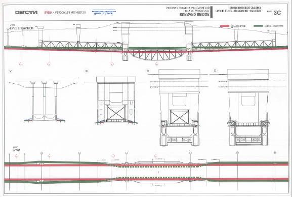
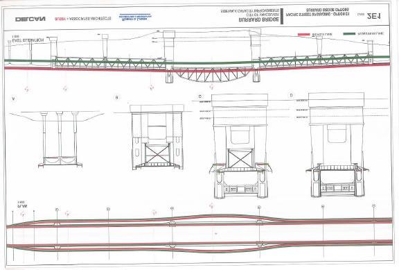
8 Report to Standing Committee on Transportation and Traffic Burrard Bridge Sidewalk Capacity Improvements for Pedestrians and Cyclists 8 ALTERNATIVES/OPTIONS OUTWARD SIDEWALK WIDENING Following up on the recommendations of the False Creek Pedestrian and Cyclist Crossing Study, staff and a consultant team evaluated a wide range of options for providing additional sidewalk capacity at the deck or upper level of the bridge. See Appendix E for more detail Out of this evaluation process emerged the recommended sidewalk widening option. This treatment provides a 6 m sidewalk with railing treatments similar to the original railings (see Figure 2). The 6 m sidewalks would narrow to pass through the existing 2.3 m portals. In discussions with stakeholders, this treatment has often been called the pinch point option. Figure 2 - Outward sidewalk widening, except at the towers (piers 3 & 4) This option provides ample space for high volumes of pedestrians and cyclists as well as inline skaters, and meets all of the transportation criteria. The existing six traffic lanes would remain, thus maintaining transit operations at today s level of service and leaving open options for bus/hov lanes or other future transit improvements. Figure 3 shows a possible treatment of 6 m wide sidewalks, with a 1 m buffer from the curb, a 2.5 m wide bike lane and a 2.5 m wide pedestrian path.
9 Report to Standing Committee on Transportation and Traffic Burrard Bridge Sidewalk Capacity Improvements for Pedestrians and Cyclists 9 Figure 3 Buffer zone, 2.5 m bike path and 2.5 m pedestrian path The narrowing of 6 m sidewalks to pass through the existing portals would create a location where pedestrians and cyclists would need to exercise additional caution. The hazard this location would present is less than at a typical intersection. The distance between these pinch points and adjacent intersections is greater than between typical intersections elsewhere in the city. A full-length widening option was also considered, but is not recommended because it would require significant alterations to the bridge towers. The Burrard Bridge Heritage Study identified seven character-defining elements of the seagate, including two primary elements, the concrete piers (i.e. towers) and concrete handrails. The recommended option, which avoids widening at the towers, would affect only the concrete handrails. The handrails, which must be replaced for safety reasons, would be relocated outward and would have limited affect on the appearance of the seagate (see Figure 2). Most significantly, the original towers would remain untouched. The Burrard Bridge Heritage Study also identified twelve character-defining elements of the roadgate. Two of these twelve elements, the concrete handrails and the perceived width of the roadway, would be affected by outward sidewalk widening (see Figures 4 and 5).
10 Report to Standing Committee on Transportation and Traffic Burrard Bridge Sidewalk Capacity Improvements for Pedestrians and Cyclists 10 Figure 4 - Existing roadgate Figure 5 - Roadgate with sidewalk widening, except at towers This sidewalk widening option has been estimated to cost $13 million. Because it widens the bridge over land not owned by the City, this sidewalk widening option would require acquisition of additional land or rights-of-way from the Province and the Squamish Nation. LANE RE-ALLOCATION In 2003, Council requested that staff revisit the possibility of re-allocating existing vehicle lanes on the bridge as cycling space. A number of options were investigated which would reduce the number of vehicle lanes on the bridge from the existing six to either five or four, without widening the sidewalks to the outside. See Appendix F for more detail. Computer simulations of traffic behaviour were done to determine the likely effect of such bridge modifications. Traffic signal operations in these computer models were based on optimizing signal timing for each lane configuration, not on current signal operations. All the various five lane options fail to meet minimum Canadian guidelines for cycling lane width or fail to provide sufficient sidewalk width to meet long-term walking and cycling needs. All these options would interfere with transit operations, slowing bus operations in at least one direction along this busy transit corridor, as well as adding to traffic congestion in Kitsilano and/or West End neighbourhoods. The four lane options would allow for the construction of pedestrian and cycling facilities which would meet long-term walking and cycling demand and would conform to Canadian guidelines for cycling and mixed-use facilities. Like the five lane options, these options would interfere with transit service, slowing bus operations in both northbound and southbound directions, as well as adding to traffic congestion in Kitsilano and West End neighbourhoods. Transit trip times, which are currently about 10 minutes in the peak direction and 5 minutes in the off-peak direction, would increase to nearly 20 minutes in both directions. Annual transit operating cost would increase by $1-2 million. The economic cost of lost time to transit riders alone would be over $1 million annually.
11 Report to Standing Committee on Transportation and Traffic Burrard Bridge Sidewalk Capacity Improvements for Pedestrians and Cyclists 11 The 4-lane/6-lane hybrid options mitigate the effect of reduced number of vehicle lanes, but not significantly, and not to the point where transit travel times across the bridge would not be unacceptably increased. Two alternative treatments for the pedestrian and bicycle facilities were developed for a 4 vehicle lane option. The first was to widen the existing sidewalks into the existing curb lanes, with pedestrians and cyclists continuing to share the sidewalks. The second was to convert the curb lanes to road-level bike lanes with a physical barrier between cyclists and vehicular traffic. This second option (see Figure 6) was overwhelmingly preferred by cyclists and pedestrians who provided feedback. Figure 6 - Road-level bike lane concept This lane reduction option would cost under $1 million. This excludes the cost of repairing the existing railings, a cost that is included in the sidewalk widening cost estimates. UNDER-SLUNG BIKE PATH Among the options reviewed early in the sidewalk capacity study were ones which proposed new bike paths be added below the existing sidewalks and road deck. These options were discarded because they would compromise navigation and due to concerns that users may avoid such a facility due to safety concerns. An option which maintained most of the navigational clearance was eventually discarded for aesthetic and other reasons. This option was revived when it became clear that the other options did not meet all the transportation and heritage objectives established for the bridge. A more straightforward treatment for an under-slung bike path was developed, albeit one that did reduce navigational clearance. If the clearance reduction were limited to 6 m, most of the vessels frequenting False Creek could continue to pass under the bridge. Like the recommended sidewalk widening option, this option uses an architectural treatment in keeping with the existing Art Deco bridge (see Figure 7).

12 Report to Standing Committee on Transportation and Traffic Burrard Bridge Sidewalk Capacity Improvements for Pedestrians and Cyclists 12 Figure 7 Under-slung bike path concept The figure above shows a fixed structure. Transport Canada has told the City it would not accept such a treatment, but has suggested that a facility which could be opened temporarily to accommodate large vessels may be acceptable. This under-slung option meets the minimum design guidelines, and it is preferred by many in the heritage community to the outward sidewalk widening options. Many cyclists consider this to be a viable solution. However, it does not address some concerns expressed by the Police Department regarding surveillance and emergency access. Fire and Rescue staff believe such a treatment could be workable. It may be unattractive to some potential users due to safety concerns. This option has only been developed at a conceptual level. Unlike the sidewalk widening options, which have been subject to engineering review to confirm that they can be built, this option may or may not be technically feasible. No cost estimates have been developed for this option. However, based on the estimates developed for the sidewalk widening options, it is reasonable to assume that fixed underslung bike paths would cost in the order of $15 million. A movable system would be more expensive than a fixed facility. This option would likely require funding beyond the $12 million currently available. Because it would widen the bridge near the bridgeheads and reduce clearance elsewhere over land not owned by the City, this option would require acquisition of additional land or rightsof-way from the Province and the Squamish Nation. The amount of land required may be less than that needed for sidewalk widening. To fairly compare this option with other options requires answering a number of questions, including:
13 Report to Standing Committee on Transportation and Traffic Burrard Bridge Sidewalk Capacity Improvements for Pedestrians and Cyclists What navigational clearances would be acceptable to the False Creek boating community and Transport Canada? 2. Is a movable under-slung bike path buildable? 3. What would such a facility look like and what would its impact be on heritage elements of the bridge? 4. How much would such a facility cost to build and operate? Further study would be required to answer these questions. NEW BRIDGE The False Creek Pedestrian and Cyclist Crossing Study investigated a number of options for new pedestrian/cyclist bridges across False Creek. None of these were advanced passed the initial list of options for a variety of reasons. More recently, Council requested that staff investigate new bridge options in the vicinity of the Burrard Bridge. Locations on both sides of the Burrard Bridge were investigated. Only one proved feasible, albeit with significant impacts on Vanier Park, Sunset Beach Park and the neighbourhood around Bute Street. Building a bridge at this location would cost at least $50 million, well beyond the available $12 million funding, and is therefore not recommended. CURB-SIDE RAILING An option which has often been suggested is the addition of a railing at the curb. While this may address the most extreme safety concerns, it would reduce the space available for pedestrians and cyclists and increase conflicts between these user groups. It does not meet any of the transportation objectives of this project and is opposed by heritage advocates and is therefore not recommended. PUBLIC CONSULTATION All the options which staff have reviewed have been subject to thorough public consultation. Appendix G lists consulted stakeholders and summarizes the opinions of the various stakeholder groups. There is broad support for outward sidewalk widening. Opposition to this approach comes primarily from the heritage advocacy community and from residents who live immediately adjacent the bridge. Concerns have been expressed by the staff of the adjacent YMCA Beach Avenue Daycare. Support for lane re-allocation comes from cyclists, environmental advocates, heritage advocates, and local residents who believe this approach will reduce traffic volumes. Opposition comes from TransLink, the downtown business community, seniors and disabled advocates, and local residents who believe this approach will increase traffic congestion and travel times.
14 Report to Standing Committee on Transportation and Traffic Burrard Bridge Sidewalk Capacity Improvements for Pedestrians and Cyclists 14 Support for the under-slung bike path comes from those that would like to see a clear separation of cycling and pedestrian routes, including seniors and disabled groups and some pedestrians and cyclists. It is also seen more favourably than outward sidewalk widening by the heritage community. It is opposed by the boating community. Transport Canada, the Police Department, and the staff of an adjacent daycare have concerns that may or may not be resolvable through design. FINANCIAL IMPLICATIONS The and Capital Plans approved funding for pedestrian and cyclist improvements to the Burrard Bridge. An existing balance of $11.7 million is available for this work. In addition, $2.4 million is available for repair or replacement of the existing railings. Cost sharing opportunities exist with senior governments. Sidewalk widening and under-slung bike paths are good candidates for TransLink s Bicycle Infrastructure Capital Cost Sharing (BICCS) program. TransLink is unlikely to provide funding for a lane re-allocation option because of the expected negative effects on transit. Outward sidewalk widening includes relocation of the railings as part of the work, and therefore has $14.1 million available funding. This option has been estimated to cost $13 million to build. Detailed design for this option can be done within available funding limits. A fixed under-slung bike path would likely cost approximately $15 million. A movable facility would be more expensive. Additional capital funding would likely be required to build such a facility. Further design for this option could be done within available funding limits. The outward sidewalk widening and under-slung bike path options would require acquisition of additional land or rights-of-way beneath and beside the bridge. CONCLUSION No option exists which meets all the objectives identified for the Burrard Bridge. The status quo does not support the City s goals for sustainable transportation. Outward sidewalk widening compromises heritage features of the bridge. Lane re-allocation will increase traffic congestion, slow goods movement and degrade transit service. An under-slung bike path will compromise navigation, presents security and access concerns, may not be feasible, and would likely require additional capital funding. Outward sidewalk widening is the only option that meets all the City s transportation objectives and is known to be acceptable to Transport Canada and to be buildable. Of the two sidewalk widening options, the one which leaves the towers intact (i.e. pinch point), has significantly less heritage impact. Staff recommend advancing this option to final design. An under-slung bike path may also meet all the City s transportation objectives, but further study would be required to confirm whether such an arrangement is structurally feasible, what its impact on heritage elements of the bridge would be, and whether it could be made acceptable to Transport Canada. * * * * *
15 APPENDIX A PAGE 1 OF 2 FALSE CREEK PEDESTRIAN AND CYCLIST CROSSING STUDY In July 2000, City Council approved a consultant study to review the feasibility of False Creek crossing options for pedestrians and cyclists and their associated costs and impacts. A number of factors had led to this study, including: Increased residential densities around False Creek. Greater interest by the public to walk or cycle across False Creek. Increased pedestrian and cyclist demand on the Burrard Bridge has led to increased conflicts between the two modes. While short term operational treatments have been implemented to enhance the shared environment on the bridge, a more permanent long term solution needs to be developed and implemented. The public, consultant team and staff initially identified 37 potential options that might improve pedestrian and/or cyclist crossings across False Creek. A screening process was developed to reduce the list of 37 to a more workable number, recognizing that options not short-listed could be studied in the future. The screening process reviewed each option against the study objectives and feasibility and then assessed the options against six broad categories: Usage Quality of Trip Cost Traffic Impacts Neighbourhood Integration Urban Design/Appearance This produced in a short list of 7 crossing options and 11 associated access or connectivity improvements. Because the study s scope allowed for only a limited number of options to be carried forward for detailed study, the two Cambie Bridge options were deferred to a future study. Five options, three on the Burrard Bridge and two on the Granville Bridge, received more detailed study. These were: Burrard Bridge Outward Sidewalk Widening (B1) Burrard Bridge Inward Sidewalk Widening (lane reduction) (B2) Burrard Bridge Low-level Crossing (B3) Granville Bridge Mid-level Suspended Crossing (G1) Granville Bridge Bike Lanes (lane reduction) (G6) The consultants completed their work in November 2001, reviewing in significantly more detail the five crossing options identified above. The consultant s key findings related to the Burrard Bridge were:
16 APPENDIX A PAGE 2 OF 2 1. The Burrard Street Bridge Corridor should be given the highest priority for improvement. 2. Those improvements should be at the bridge deck level either through widening the sidewalks outside the existing railing (B1) or narrowing the roadway (B2). These findings were based on the following observations: Pedestrian and cycling demand along the Burrard Street Bridge Corridor is and will continue to be the highest of the three bridge crossing corridors. Safety issues persist on the bridge deck sidewalks which must be addressed. Commuter pedestrian and cycling demand, which is overall higher than recreational demand, is best served at the bridge deck level rather than a low level option under the bridge. In light of these, the Consultant recommended that further design work be pursued in the form of a "deck level of Burrard Bridge" study that would, in recognition of the heritage sensitivities, "marry" the talents of an engineer and an architect to come up with acceptable design solutions. The goal of the study would be to examine both deck level options to best determine a permanent solution that solves both the short and long term transportation needs along the corridor.
17 APPENDIX B PAGE 1 OF STAFF REPORT In March 2002, staff reported to Council, consolidating the work of consultants and staff s own investigations. Staff recommended that an overall long term strategy for making improvements to the pedestrian and cycling environments across False Creek be supported by Council. The elements of this strategy are: Improve the safety and capacity of pedestrian and cycling routes along the three bridge corridors (Burrard, Granville and Cambie) Identify and include street, bridge end, and Seawall connections as part of any proposed improvements to the bridges Favour solutions that optimize usage, safety, quality of trip, cost, and minimize negative impacts on traffic, heritage, urban design and neighbourhoods Support and encourage a role for water-borne transportation to serve the diverse travel needs If feasible, that the deck level or upper level of the Burrard Bridge be the first to be structurally modified to increase pedestrian and cycling capacity, followed by a study of improvements in the Granville corridor and then a widening of the west sidewalk of the Cambie Bridge. That staff review options to improve pedestrian and cycling facilities on the deck of the Granville Bridge. That widening of the west sidewalk of the Cambie Bridge be done as part of the study of the redevelopment of SE False Creek That staff report back to Council upon completion of the physical work on the deck level of Burrard Bridge to re-confirm the scope and timing of subsequent priorities to improve the pedestrian and cycling environment across False Creek. Staff concluded that the Burrard Bridge should be the highest priority for improvements to pedestrian and cycling environment and capacity. They stated that existing high pedestrian and bicycle demand on the Burrard Bridge and safety issues that persist due to the limited width and shared usage of the sidewalk need to be addressed. They noted that future increases in demand will only exacerbate these existing capacity and safety issues. Staff concurred with the consultant s conclusion regarding low level crossing on the Burrard Bridge. They agreed that it could work well for recreational users as it connects the north and south seawalls, but that the priority for improvements should be at the deck or upper level of the bridge where the higher volume commuter pedestrian and cyclist trips demand is. The public also agreed that the Burrard Bridge should be the highest priority for pedestrian and cycling improvement, and that any changes should be sensitive to the heritage aspect of the bridge. Heritage Vancouver is strongly opposed to any option that could potentially alter the appearance or integrity of the bridge. While the public consultation in this study did not capture opinions from the motorist segment of the public, a 1995 survey determined that 7 in 10 bridge users would prefer maintaining the existing 6 lanes on the bridge and widening the bridge outward as opposed to reducing the number of lanes on the bridge from 6 to 5.
18 APPENDIX B PAGE 2 OF 2 Staff noted that whatever improvements are made to the pedestrian and bicycle facilities on the Burrard Bridge must be considered permanent and long term. It is reasonable to expect that these improvements will meet transportation needs in this corridor for the next 50 years. Staff did not support option B2, which would narrow the bridge deck from 6 lanes to 5 for the following reasons: 1. Narrowing the bridge by one vehicle lane may not serve the long term transportation needs of this corridor to and from the Downtown Peninsula in terms of: preserving existing road capacity and future flexibility for transit and/or vehicular traffic (e.g. the installation of bus/hov lanes or future rapid transit becomes problematic if only one lane is left for general purpose and goods movement vehicles) reducing the level of service for transit, goods movement vehicles, and general purpose traffic crossing the bridge. 2. Widening the sidewalks inward or providing bike lanes may be problematic and not adequately resolve the existing pedestrian and bicycle issues: The 1.5 metre bike lane widths would not provide room for faster cyclists to pass slower cyclists without encroaching into the adjacent vehicle lane, and the 1.5m additional sidewalk widths do not provide enough capacity with the existing sidewalk width to allow for the separation of pedestrians and cyclists. The modest increase in width may not provide sufficient capacity for future increases in pedestrian and cyclist demand. The effectiveness of using the area through the centre of the bridge must be questioned. Cyclists would be riding between relatively fast moving vehicles and the centre span structure. This would be a very poor quality of trip for many users. It is likely many would choose to stay on the outside of the centre span structure, on the existing sidewalk, thus not resolving the existing situation. Staff did endorse further development of option B1, outward sidewalk widening, and added a recommendation to investigate other options at the deck or upper level of the Burrard Bridge which might better address heritage concerns. Specifically, staff recommended the development of a more detailed and technical design that will provide additional sidewalk capacity at the deck or upper level of Burrard Bridge at the same time maintaining the existing six lanes for vehicle traffic. The goal of this step is to select a preferred design alternative and to then proceed to construction The scope of work would include undertaking design of the deck or upper level design solutions on the Burrard Bridge including the outward extension of the sidewalks (3 metres on each side) and alternatives that are consistent with the transportation capacity, safety, and heritage principles as outlined in this report. In March 2002 Council approved staff s recommendations and in May 2002 they approved a consulting contract to complete the recommended design work.
19 APPENDIX C PAGE 1 OF 1 BRIDGE RIGHTS-OF-WAY The Burrard Bridge occupies road right-of-way and several parcels of land. Most of these parcels are owned by the City or are the subject of Provincial Crown leases to the City. One parcel, immediately south of the Aquatic Centre, is owned by the Province. Another parcel, south of Vanier Park, was a rail yard when the bridge was built and was owned by the CPR between the late 1800 s and Prior to construction of the bridge, the CPR and the Government of Canada granted permission to build on this land. In 2002, the BC Court of Appeal affirmed a decision of the BC Supreme Court, returning this land to the Government of Canada for the sole use and benefit of the Squamish Nation as Reserve land. In 2003, the Court of Appeal clarified its decision and in 2004 the City learned that neither the CPR nor the Government of Canada had attempted to appeal those decisions to the Supreme Court of Canada. Any options which widen the bridge or affect the clearance beneath the bridge in these parcels will require the approval of the Squamish Nation, the federal government and/or the provincial government. The City has recently entered into discussions with the Squamish aimed at establishing a government-to-government relationship as the City has done with the Musqueam Indian Band. Issues related to the Burrard Bridge will be discussed as part of broader discussions related to exploring a co-operative relationship between governments.
20 APPENDIX D PAGE 1 OF 1 DESIGN GUIDELINES The Transportation Association of Canada has established guidelines for new cycling facilities in Canada. Some of the relevant guidelines which apply to the Burrard Bridge are listed below. These minimum dimensions assume single-file cycling (i.e. moderate volume, no passing) and incorporate required clearances to drop-offs and vertical obstructions. They do not accommodate shared use by inline skaters. Minimum on-road bike lane width Minimum sidewalk bike lane width Minimum separated (e.g. under-slung) bike path width 2.1 m (includes clearance to curb) 2.5 m (includes clearance to curb) 2.7 m (includes clearances to railings) Allowing cyclist to pass one another and providing sufficient capacity for high volumes of cyclists requires wider lanes. Preferred on-road bike lane width Preferred sidewalk bike lane width Preferred separated (e.g. under-slung) bike path width 3.1 m (includes clearance to curb) 3.5 m (includes clearance to curb) 3.7 m (includes clearances to railings) European guidelines suggest a minimum lane width of 2.6m where inline skating co-exists with cycling. There are no Canadian standards for sidewalk width. US sources suggest 1.8m to 2.1m is required for two individuals to comfortably pass, and 2.4m to 2.6m is required for an individual to pass a couple walking abreast. Preferred sidewalk pedestrian width 2.5 m 2.6m is, perhaps not coincidentally, the width of the existing sidewalk.

21 APPENDIX E PAGE 1 OF 8 DEVELOPMENT OF SIDEWALK WIDENING OPTIONS Following up on the recommendations of the False Creek Pedestrian and Cyclist Crossing Study, staff and a consultant team evaluated a wide range of options for providing additional sidewalk capacity at the deck or upper level of the bridge. These included: Outward sidewalk widening New bike deck above existing sidewalks New bike path beside existing sidewalks (2 variants) New bike path below existing sidewalks and road deck (2 variants) New two-way bike path beside existing sidewalk on one side only These options are shown on the following pages. This initial list of options was evaluated against a number of criteria including function, constructability, aesthetics, heritage, navigation and cost. The resulting short list yielded three options for further development: outward sidewalk widening, and the two variations of new bike paths beside the existing sidewalks.

22 APPENDIX E PAGE 2 OF 8

23 APPENDIX E PAGE 3 OF 8


24 APPENDIX E PAGE 4 OF 8 Through a process of technical review by City staff and the consultant team, and consultation with stakeholders, these options evolved to become the two shown in Figures E1 and E2. Figure E1

25 APPENDIX E PAGE 5 OF 8 Figure E1 shows a contemporary addition beside and below the existing sidewalks to create a new 3 m bike path. This option was eventually discarded for aesthetic, marine navigation and user desirability reasons. Objections to this option included concerns from Police and Fire & Rescue about their ability to respond to emergencies on such a facility. Figure E2 Figure E2 shows a contemporary addition to the Art Deco bridge at the existing sidewalk level to widen the sidewalks to 6 m. This treatment addressed all the functional requirements, but questions were raised regarding the aesthetics of the contemporary / Art Deco mix of styles. To some, this was an appropriate response to the desire to differentiate the original bridge from later modifications. To others, it disrupted the look of the bridge. Another critique of this approach was the visual impact on the main towers. These continuous vertical elements would be interrupted at the road deck level. In response to these concerns, two more options were developed with an architectural treatment more consistent with the Art Deco vernacular of the existing bridge. The first is functionally identical to the contemporary sidewalk widening, creating a 6 m sidewalk for the full length of the bridge, but with railing treatments similar to the original railings. This option would require the removal of the existing tower balconies and their replacement with larger ones (see Figure E3).
26 APPENDIX E PAGE 6 OF 8 Figure E3 - Full-length outward sidewalk widening The second option addressed the impact on the towers by eliminating the sidewalk widening at the towers (see Figure E4). The 6 m sidewalks would narrow to pass through the existing 2.3 m portals. Figure E4 - Outward sidewalk widening, except at the towers (piers 3 & 4) Except at the towers, these two options are the same. They have 6m wide sidewalks, providing ample space for high volumes of pedestrians and cyclists as well as inline skaters, and meet all of the transportation criteria. They maintain the existing six traffic lanes. This maintains transit operations at today s level of service and leaves open options for bus/hov lanes or other transit improvements. Figure E5 below shows a possible treatment of 6 m wide sidewalks, with a 1 m buffer from the curb, a 2.5 m wide bike lane and a 2.5 m wide pedestrian path.

27 APPENDIX E PAGE 7 OF 8 Figure E5 Both sidewalk widening options compromise the heritage elements of the bridge. The Burrard Bridge Heritage Study identified seven character-defining elements of the seagate parti. A full-length outward sidewalk widening would affect both primary elements, the concrete piers and concrete handrails, and would significantly alter the appearance of the seagate (see Figure E3). However, the scheme which avoided widening at the towers (piers 3 & 4) would affect only the concrete handrails. The handrails would be relocated outward and would have much less affect on the appearance of the seagate than a full-length sidewalk widening (see Figure E4). The Burrard Bridge Heritage Study also identified twelve character-defining elements of the roadgate parti. Two of these twelve elements, the concrete handrails and the perceived width of the roadway, would be affected by outward sidewalk widening (see Figures E6 and E7). A full-length sidewalk widening would also have the effect of transforming the road gate into an arch.
28 APPENDIX E PAGE 8 OF 8 Figure E6 - Existing roadgate Figure E7 - Roadgate with sidewalk widening, except at towers The full-length outward sidewalk widening has been estimated to cost $14 million. The reduced widening which would leave the towers intact would cost $13 million.
29 APPENDIX F PAGE 1 OF 3 LANE RE-ASSIGNMENT In 2003, Council requested that staff revisit the possibility of reassigning existing vehicle lanes on the bridge as cycling space. A number of options were investigated which would reduce the number of vehicle lanes on the bridge from the existing six to either five or four, without widening the sidewalks to the outside. The configurations investigated included: 5 vehicle lanes (2 northbound, 3 southbound), sidewalks widened to 4m 5 vehicle lanes (3 northbound, 2 southbound), sidewalks widened to 4m 5 vehicle lanes (2 northbound, 2 southbound, 1 reversing), sidewalks widened to 4m 5 vehicle lanes (2 northbound, 2 southbound, 1 transit), sidewalks widened to 4m 5 vehicle lanes (2 northbound, 2 southbound, 1 reversing transit), sidewalks widened to 4m 5 vehicle lanes (1 northbound, 1 southbound, 1 reversing, 2 transit lanes), sidewalks widened to 4m 5 vehicle lanes (all above configurations), bike lanes at road level, existing sidewalk 4 vehicle lanes (2 northbound, 2 southbound), sidewalks widened inward to 5-6m 4 vehicle lanes (1 northbound, 1 southbound, 2 transit), sidewalks widened inward to 5-6m 4 vehicle lanes (all above configurations), bike lanes at road level, existing sidewalk In addition to the above options, which assume no outward sidewalk widening, two additional options which assume limited outward widening at the north end of the bridge were assessed. These two hybrid options, described below, were an effort to mitigate the impacts on traffic of lane re-allocation. 4 vehicle lanes (2 northbound, 2 southbound) and sidewalks widened inward to 5-6m south of Pier 4 (north tower), 6 vehicle lanes and outward sidewalk widening north of Pier 4 4 vehicle lanes (2 northbound, 2 southbound) sidewalks widened inward to 5-6m south of Pier 6 (north shore of false Creek), 6 vehicle lanes and outward sidewalk widening north of Pier 6 Figure F1 below shows how a transition from 4 lanes to 6 lanes might happen at the north tower (Pier 4) in a hybrid option.

30 APPENDIX F PAGE 2 OF 3 Figure F1 - Transition between 4-lane inward sidewalk widening and 6-lane outward sidewalk widening. Computer simulations of traffic behaviour were done to determine the likely effect of such bridge modifications. Traffic signal operations in these computer models were based on optimizing signal timing for each lane configuration, not on current signal operations. All the various five lane options fail to meet minimum Canadian guidelines for cycling lane width or fail to provide sufficient sidewalk width to meet long-term walking and cycling needs. All these options would interfere with transit operations, slowing bus operations in at least one direction along this busy transit corridor, as well as adding to traffic congestion in Kitsilano and/or West End neighbourhoods. Even the option which provides transit lanes on the bridge would be expected to increase congestion beyond the bridgeheads to the extent that transit operations in the downtown would be adversely affected. The four lane options would allow for the construction of pedestrian and cycling facilities which would meet long-term walking and cycling demand and would conform to Canadian guidelines for cycling and mixed-use facilities. Like the five lane options, these options would interfere with transit operations, slowing bus operations in both northbound and southbound directions, as well as adding to traffic congestion in Kitsilano and West End neighbourhoods. Transit trip times, which are currently about 10 minutes in the peak direction and 5 minutes in the off-peak direction, would increase to nearly 20 minutes in both directions. Annual transit operating cost would increase by $1-2 million. The economic cost of lost time to transit riders alone would be over $1 million annually.
Governance and Priorities Committee Report For the July 2, 2015 Meeting
 CITY OF VICTORIA For the July 2, 2015 Meeting To: Governance and Priorities Committee Date: From: Subject: Brad Dellebuur, A/Assistant Director, Transportation and Parking Services Executive Summary The
Standing Committee on Policy and Strategic Priorities. Potential Granville Bridge Connector Public Engagement
 ADMINISTRATIVE REPORT Report Date: January 22, 2019 Contact: Paul Storer Contact No.: 604.873.7693 RTS No.: 12877 VanRIMS No.: 08-2000-20 Meeting Date: January 30, 2019 TO: FROM: SUBJECT: Standing Committee
102 Avenue Corridor Review
 February 26, 2015 102 Avenue Corridor Review Transportation Association of Canada Road Safety Engineering Award Submission for the City of Edmonton Introduction Transportation Association of Canada Road
CITY OF OTTAWA ROADWAY MODIFICATION APPROVAL UNDER DELEGATED AUTHORITY
 RMA-2015-ATM-038 CITY OF OTTAWA ROADWAY MODIFICATION APPROVAL UNDER DELEGATED AUTHORITY DATE: April 22, 2015 SUBJECT Approval of Roadway Modifications Recommended through an Area Traffic Management Study
CITY OF VANCOUVER ADMINISTRATIVE REPORT
 CITY OF VANCOUVER ADMINISTRATIVE REPORT Report Date: May 31, 2007 Author: Paul Storer Phone No.: 604.873.7693 RTS No.: 06348 VanRIMS No.: 13-5000-20 Meeting Date: June 12, 2007 TO: FROM: SUBJECT: Standing
Design of Stanley Park S-Curve
 ADMINISTRATIVE REPORT Date: May 4, 2001 TO: FROM: Author/Local: F. Klotzbach/7118 RTS NO. 01644 CC File No. Standing Committee on Transportation and Traffic General Manager of Engineering Services, in
Minor Amendments to the Street and Traffic By-law 2849 and Skateboards in Protected Bike Lanes
 ADMINISTRATIVE REPORT Report Date: October 31, 2017 Contact: Lon LaClaire Contact No.: 604.873.7336 RTS No.: 12241 VanRIMS No.: 08-2000-20 Meeting Date: November 15, 2017 TO: FROM: SUBJECT: Standing Committee
POLICY: TRAFFIC CALMING
 2006 MAY REFERENCE: COUNCIL APPROVED BY COUNCIL MAY 23, 2006 CITY OPERATIONS - NO. 608 POLICY: TRAFFIC CALMING A. All requests for traffic calming within the City shall be considered in accordance with
Improving Cyclist Safety at the Dundas Street West and Sterling Road Intersection
 STAFF REPORT ACTION REQUIRED Improving Cyclist Safety at the Dundas Street West and Sterling Road Intersection Date: August 17, 2012 To: From: Wards: Reference Number: Public Works and Infrastructure Committee
2014/2015 BIKE ROUTE PLAN 83 AVENUE PROTECTED BIKE LANE
 About the Project 2014/2015 BIKE ROUTE PLAN The City of Edmonton is planning a major bike route on the south side of Edmonton. This bike route is one part of a plan to provide citizens with transportation
WELCOME Public Information Centre
 WELCOME Public Information Centre Fernforest Drive Brampton Soccer Centre Community Room #2 Tuesday January 19, 2016 6:30 p.m.to 9:00 p.m. Please sign in Neighbourhood Traffic Calming Guide Background
REPORT TO MAYOR AND COUNCIL
 F.4 REPORT TO MAYOR AND COUNCIL PRESENTED: SEPTEMBER 12, 2016 - REGULAR AFTERNOON MEETING REPORT: 16-85 FROM: ENGINEERING DIVISION FILE: 5460-13-20-005 SUBJECT: RAINBOW CROSSWALK AT GLOVER ROAD AND MAVIS
Corporate. Report COUNCIL DATE: May 25, 1998 NO: R1500 REGULAR COUNCIL. TO: Mayor & Council DATE: April 27, 1998
 R1500 : Traffic Safety at 25 Avenue and 128 Street Intersection Corporate NO: R1500 Report COUNCIL DATE: May 25, 1998 REGULAR COUNCIL TO: Mayor & Council DATE: April 27, 1998 FROM: General Manager, Engineering
Agenda Item # Page # RECOMMENDATION
 TO: FROM: SUBJECT: CHAIR AND MEMBERS CIVIC WORKS COMMITTEE MEETING ON FEBRUARY 2, 2016 JOHN BRAAM, P. ENG. MANAGING DIRECTOR, ENVIRONMENTAL & ENGINEERING SERVICES AND CITY ENGINEER FIELD MARSHAL WOLSELEY
Chapter 7. Transportation. Transportation Road Network Plan Transit Cyclists Pedestrians Multi-Use and Equestrian Trails
 Chapter 7 Transportation Transportation Road Network Plan Transit Cyclists Pedestrians Multi-Use and Equestrian Trails 7.1 TRANSPORTATION BACKGROUND The District of Maple Ridge faces a number of unique
Corporate. Report COUNCIL DATE: June 26, 2006 NO: C012 COUNCIL-IN-COMMITTEE. TO: Mayor & Council DATE: June 22, 2006
 Corporate NO: C012 Report COUNCIL DATE: June 26, 2006 COUNCIL-IN-COMMITTEE TO: Mayor & Council DATE: June 22, 2006 FROM: General Manager, Engineering FILE: 0410-20(MoT/Gate) SUBJECT: Surrey Response on
Downey Road. Transportation Improvement Study
 Downey Road Transportation Improvement Study Workshop 2 Participant Handbook Workshop 1 May 18 and 19, 2016 Workshop 2 June 23 and 28, 2016 Prepared By: City of Guelph Paradigm Transportation Solutions
WELCOME TO OPEN HOUSE # 1 June 14, 2017
 Langstaff Road Weston Road to Highway 7 Class Environmental Assessment Study WELCOME TO OPEN HOUSE # 1 June 14, 2017 Please sign in and join our mailing list Purpose of Open House #1 & Study Area York
5. RUNNINGWAY GUIDELINES
 5. RUNNINGWAY GUIDELINES These guidelines should be considered collectively when making runningway decisions. A runningway is the linear component of the transit system that forms the right-of-way reserved
Standing Committee on Policy and Strategic Priorities
 POLICY REPORT Report Date: January 15, 2019 Contact: Steve Brown Contact No.: 604.873.9733 RTS No.: 12955 VanRIMS No.: 08-2000-20 Meeting Date: January 30, 2019 TO: FROM: SUBJECT: Standing Committee on
A CHANGING CITY. of Edmonton, it is essential that it reflects the long-term vision of the City.
 A CHANGING CITY By the year 2040, Edmonton will be home to more than 1 million people. To accommodate growth and support a healthy and compact city, we need a new approach to development/redevelopment
CITY OF SAINT JOHN TRAFFIC CALMING POLICY
 CITY OF SAINT JOHN TRAFFIC CALMING POLICY VERSION: 1.0 April 10, 2012 Pedestrians, Cyclists and Motorists Sharing Street Spaces CONTENTS INTRODUCTION... 3 POLICY GOAL... 3 POLICY OBJECTIVES... 3 GUIDING
TO: Board Members Vancouver Park Board FROM: General Manager Parks and Recreation SUBJECT: Seaside Greenway Improvements
 Date: October 1, 2013 TO: Board Members Vancouver Park Board FROM: General Manager Parks and Recreation SUBJECT: Seaside Greenway Improvements RECOMMENDATION A. THAT the Board approve the new bike paths
Welcome. If you have any questions or comments on the project, please contact:
 Welcome This drop-in public open house is intended to provide information about the Bay Street bike lanes project. This project proposes a dedicated cycling facility along Bay Street between Aberdeen Avenue
Tonight is an opportunity to learn about the Study and ask questions of the Study Team members.
 Exhibit 1 Welcome Second Open House Tonight is an opportunity to learn about the Study and ask questions of the Study Team members. A first Public Open House was held on September 18th, 2013 which presented
Chapter 3 DESIGN SPECIFICATIONS
 Brampton PathWays Planning and Design Guidelines 27 Chapter 3 DESIGN SPECIFICATIONS 3.1 CLASS 1 MULTI-USE PATH Off-road multi-use trails are the backbone of the Brampton PathWays Network. They are typically
2014/2015 BIKE ROUTE PLAN 83 AVENUE PROTECTED BIKE LANE
 About the Project The City of Edmonton is planning a major bike route on the southside of Edmonton. The Strathcona Bike Route will connect the communities of Strathcona, Garneau and the University area,
Public Information Centre
 WELCOME Public Information Centre Father Tobin Road Lougheed Middle School - Library Wednesday November 7, 2012 7:00 p.m.to 9:00 p.m. Please sign in Neighbourhood Traffic Calming Guide Background The City
CITY OF COCOA BEACH 2025 COMPREHENSIVE PLAN. Section VIII Mobility Element Goals, Objectives, and Policies
 CITY OF COCOA BEACH 2025 COMPREHENSIVE PLAN Section VIII Mobility Element Goals, Objectives, and Policies Adopted August 6, 2015 by Ordinance No. 1591 VIII MOBILITY ELEMENT Table of Contents Page Number
Implementation Report # False Creek Bridges
 Implementation Report #1 2013-04-24 False Creek Bridges ECONOMY PEOPLE ENVIRONMENT Intro Council Requested Report Back Topics Progress on Planning for Broadway Subway False Creek Bridges Local Transit
University of Victoria Campus Cycling Plan Terms of Reference. 1.0 Project Description
 University of Victoria Campus Cycling Plan Terms of Reference 1.0 Project Description The Campus Cycling Plan, a first for the University, will provide a comprehensive and coordinated approach to support
Living Streets Policy
 Living Streets Policy Introduction Living streets balance the needs of motorists, bicyclists, pedestrians and transit riders in ways that promote safety and convenience, enhance community identity, create
South Park Street Bicycle Lane Improvements. Public Engagement. November 2017
 South Park Street Bicycle Lane Improvements Public Engagement November 2017 South Park Street Bicycle Lane Improvements WHAT WE HEARD REPORT Introduction To improve safety and bicycle route continuity
TRANSPORTATION NEEDS ASSESSMENT
 TRANSPORTATION NEEDS ASSESSMENT A travel demand analysis was carried out to determine the operational issues and the potential benefit that adding traffic capacity would have on the road network. All the
WEST AND SOUTH WEST RING ROAD DOWNSTREAM TRAFFIC IMPACTS
 Page 1 of 9 EXECUTIVE SUMMARY Alberta Transportation ( AT ) is preparing to construct the final sections of the Calgary Ring Road. This includes the South West Ring Road ( SWRR ) (from Lott Creek Blvd
Transportation Master Plan Advisory Task Force
 Transportation Master Plan Advisory Task Force Network Alternatives & Phasing Strategy February 2016 BACKGROUND Table of Contents BACKGROUND Purpose & Introduction 2 Linking the TMP to Key Council Approved
Frequently Asked Questions (FAQ)
") Frequently Asked s (FAQ) Study Process... 2 Rapid Transit Service and Operations... 5 Public Consultation... 8 Business Impacts... 8 Design and Property Impacts... 9 Construction Impacts...12 Traffic,
Frequently Asked s (FAQ) Study Process... 2 Rapid Transit Service and Operations... 5 Public Consultation... 8 Business Impacts... 8 Design and Property Impacts... 9 Construction Impacts...12 Traffic,
Appendix A. Road Classification Review of Outstanding Issues and Proposed Classifications (All Wards) Staff Report Road Classification System
 Staff Report Road Classification System") Appendix A Road Classification Review of Outstanding Issues and Proposed Classifications (All Wards) Staff Report 2000 A.1 of A.10 A.2 of A.10 STAFF REPORT January 26, 2000 To: From: Works Committee Barry
Appendix A Road Classification Review of Outstanding Issues and Proposed Classifications (All Wards) Staff Report 2000 A.1 of A.10 A.2 of A.10 STAFF REPORT January 26, 2000 To: From: Works Committee Barry
APPENDIX 2 LAKESHORE ROAD TRANSPORTATION REVIEW STUDY EXECUTIVE SUMMARY
 APPENDIX 2 LAKESHORE ROAD TRANSPORTATION REVIEW STUDY EXECUTIVE SUMMARY Appendix 2 City of Mississauga Lakeshore Road FINAL REPORT Transportation Review Study December 2010 EXECUTIVE SUMMARY Study Purpose
Municipal Class EA To Address Traffic Congestion On The Ontario Street Corridor (Grand Bend) Public Information Meeting June 4, 2018
 Public Information Meeting June 4, 2018") Municipal Class EA To Address Traffic Congestion On The Ontario Street Corridor (Grand Bend) Public Information Meeting June 4, 2018 Background Agenda Traffic Study Update Class EA Alternatives Bridge
Municipal Class EA To Address Traffic Congestion On The Ontario Street Corridor (Grand Bend) Public Information Meeting June 4, 2018 Background Agenda Traffic Study Update Class EA Alternatives Bridge
HIGHBURY AVENUE/HAMILTON ROAD INTERSECTION IMPROVEMENTS PUBLIC INFORMATION CENTRE 1 MAY 14, 2015
 HIGHBURY AVENUE/HAMILTON ROAD INTERSECTION IMPROVEMENTS Municipal Class Environmental Assessment PUBLIC INFORMATION CENTRE 1 MAY 14, 2015 ACCESSIBILITY Under the Accessibility Standards 2015 for Customer
Tonight is for you. Learn everything you can. Share all your ideas.
 Strathcona Neighbourhood Renewal Draft Concept Design Tonight is for you. Learn everything you can. Share all your ideas. What is Neighbourhood Renewal? Creating a design with you for your neighbourhood.
Edenbrook Hill Drive Traffic Calming Study
 WELCOME Public Information Centre Edenbrook Hill Drive Traffic Calming Study Fletchers Meadow Secondary School Wednesday January 20, 2016 6:30 p.m.to 9:00 p.m. Please sign in Neighbourhood Traffic Calming
ECONOMY PEOPLE ENVIRONMENT
 Report Back on Local Transit Improvements May 29, 2013 ECONOMY PEOPLE ENVIRONMENT Intro Council Requested Report Back Topics Progress on Planning for Broadway Subway False Creek Bridges Local Transit Improvements
CITY OF WEST KELOWNA COUNCIL POLICY MANUAL
 CITY OF WEST KELOWNA COUNCIL POLICY MANUAL Page 1 of 7 DEPARTMENT: Engineering Services SUBJECT: Traffic Calming Policy (Revised June 6, 2017) Policy Statement: The provision of traffic calming measures
2.0 LANE WIDTHS GUIDELINE
 2.0 LANE WIDTHS GUIDELINE Road Engineering Design Guidelines Version 2.0.1 May 2018 City of Toronto, Transportation Services City of Toronto Page 0 Background In early 2014, Transportation Services initiated
RECOMMENDATION: 1) that the existing Traffic Bridge be replaced with a modern steel truss bridge as outlined in this report;
 that the existing Traffic Bridge be replaced with a modern steel truss bridge as outlined in this report;") E) Traffic Bridge Needs Assessment and Functional Planning Study Final Report (File: CK 6050 8; IS 6332 24; and IS 6050 2) RECOMMENDATION: 1) that the existing Traffic Bridge be replaced with a modern
E) Traffic Bridge Needs Assessment and Functional Planning Study Final Report (File: CK 6050 8; IS 6332 24; and IS 6050 2) RECOMMENDATION: 1) that the existing Traffic Bridge be replaced with a modern
CURBSIDE ACTIVITY DESIGN
 5 CURBSIDE ACTIVITY DESIGN This chapter provides design guidance for separated bike lanes adjacent to curbside activities including parking, loading and bus stops. Typical configurations are presented
General Design Factors
 Chapter 3: 3-1.0 Introduction General Design Factors Mn/DOT s goals include encouraging and accommodating safe bicycling. From a design perspective, these goals are achieved by first having an understanding
TRAFFIC CALMING GUIDE FOR TORONTO CITY OF TORONTO TRANSPORTATION SERVICES DIVISION
 TRAFFIC CALMING GUIDE FOR TORONTO CITY OF TORONTO TRANSPORTATION SERVICES DIVISION CITY OF TORONTO TRANSPORTATION SERVICES DIVISION 2016 TRAFFIC CALMING GUIDE FOR TORONTO TABLE OF CONTENTS Introduction
Toronto and East York Community Council. Director, Transportation Services, Toronto and East York District
 No Turn on Red Regulations STAFF REPORT ACTION REQUIRED Date: June 1, 2010 To: From: Toronto and East York Community Council Director, Transportation Services, Toronto and East York District Wards: Trinity
Southwest Bus Rapid Transit (SW BRT) Functional Planning Study - Executive Summary January 19 LPT ATTACHMENT 2.
 Functional Planning Study - Executive Summary January 19 LPT ATTACHMENT 2.") Southwest Bus Rapid Transit (SW BRT) Functional Planning Study - Executive Summary 2011 January 19 1 of 19 Introduction This executive summary presents the results of the Southwest Bus Rapid Transit (SW
Southwest Bus Rapid Transit (SW BRT) Functional Planning Study - Executive Summary 2011 January 19 1 of 19 Introduction This executive summary presents the results of the Southwest Bus Rapid Transit (SW
Terwillegar Drive Expressway Draft Concept Plan
 Terwillegar Drive Expressway Draft Concept Plan Anthony Henday Drive to Whitemud Drive November 28 5:00-8:00 p.m. December 1 10:00 a.m. - 3:00 p.m. Let s Talk Today you can: Learn about the new direction
3 TRAFFIC CONTROL SIGNAL TIMING AND SYNCHRONIZATION
 Report No. 8 of the Transportation Services Committee Regional Council Meeting of October 20, 2011 3 TRAFFIC CONTROL SIGNAL TIMING AND SYNCHRONIZATION The Transportation Services Committee recommends:
8 PROPOSED ROUNDABOUT DUFFERIN STREET AND KING VAUGHAN ROAD INTERSECTION CITY OF VAUGHAN
 8 PROPOSED ROUNDABOUT DUFFERIN STREET AND KING VAUGHAN ROAD INTERSECTION CITY OF VAUGHAN The Transportation Services Committee recommends the adoption of the recommendation contained in the following report
Harbord Street and Hoskin Avenue Bicycle Lane Upgrades
 STAFF REPORT ACTION REQUIRED and Bicycle Lane Upgrades Date: April 22, 2014 To: From: Wards: Reference Number: Public Works and Infrastructure Committee General Manager, Transportation Services 19 and
CHAIR AND MEMBERS CIVIC WORKS COMMITTEE MEETING ON JANUARY 10, 2017
 TO: FROM: SUBJECT: CHAIR AND MEMBERS CIVIC WORKS COMMITTEE MEETING ON JANUARY 10, 2017 KELLY SCHERR, P.ENG., MBA, FEC MANAGING DIRECTOR ENVIRONMENTAL & ENGINEERING SERVICES AND CITY ENGINEER QUEENS AVENUE
Coquitlam Cross-town Bike Route Improving Bicycle Facilities in a Mature Suburban Environment
 Coquitlam Cross-town Bike Route Improving Bicycle Facilities in a Mature Suburban Environment Sarah Rocchi, Vice-President, Projects, Opus International Consultants (Main Presenter) Catherine Mohoruk,
Simulation Analysis of Intersection Treatments for Cycle Tracks
 Abstract Simulation Analysis of Intersection Treatments for Cycle Tracks The increased use of cycle tracks also known as protected bike lanes has led to investigations of how to accommodate them at intersections.
In station areas, new pedestrian links can increase network connectivity and provide direct access to stations.
 The Last Mile Planning for Pedestrians Planning around stations will put pedestrians first. Making walking to stations safe and easy is important; walking will be a part of every rapid transit Accessible
Rebuilding Highway 7 Town Centre Boulevard to Sciberras Road
 Rebuilding Highway 7 Town Centre Boulevard to Sciberras Road Project Status Update Presentation to City of Markham Development Services Committee October 22, 2013 Presentation Outline Background Status
Public Works and Infrastructure Committee. General Manager, Transportation Services
 STAFF REPORT ACTION REQUIRED Extending the Bay Street Bicycle Lanes Date: May 16, 2013 To: From: Public Works and Infrastructure Committee General Manager, Transportation Services Wards: Toronto Centre
Chapter 5 Future Transportation
 Chapter 5 Future Transportation The Future Land Use Plan identifies the desired land use designations. The land uses desired for Crozet depend, in large part, on the success of the transportation system,
COUNCIL POLICY NAME: COUNCIL REFERENCE: 06/119 06/377 09/1C 10llC 12/1C INDEX REFERENCE: POLICY BACKGROUND
 COUNCIL POLICY NAME: COUNCIL ADVISORY COMMITTEES - TERMS OF REFERENCE ISSUED: APRIL 3, 2006 AMENDED: NOVEMBER 27, 2006 NOVEMBER 23, 2009 JANUARY 11, 2010 DECEMBER 17, 2012 POLICY COUNCIL REFERENCE: 06/119
Moving Cambridge. City of Cambridge Transportation Master Plan Public Consultation Centre. March 7, :00 8:00 PM.
 City of Cambridge Transportation Master Plan Public Consultation Centre March 7, 2018 5:00 8:00 PM Region of Waterloo City of Cambridge Transportation Master Plan Public Consultation Centre March 7, 2018
McKenzie Interchange Project Fall 2015 Engagement. Appendix 2: Engagement Materials and Feedback Form
 Fall 2015 Engagement Appendix 2: Engagement Materials and Feedback Form Welcome to the McKenzie Interchange Project Open House! Purpose of Open House To provide you with information regarding the project
to the Public Information Centre for the Downtown Traffic Study
 to the Public Information Centre for the Downtown Traffic Study City of Sault Ste. Marie July 25, 2018 Purpose of Study Determine if changes to one-way corridors can enhance downtown s character and spaces
a) receiving of legal advice subject to solicitor client privilege and labour relations regarding contract negotiations
 receiving of legal advice subject to solicitor client privilege and labour relations regarding contract negotiations") Regional Municipality of Waterloo Planning and Works Committee Agenda Tuesday, April 4, 2017 9:30 a.m. (Following Closed Session) Regional Council Chamber 150 Frederick Street, Kitchener Media Release:
Regional Municipality of Waterloo Planning and Works Committee Agenda Tuesday, April 4, 2017 9:30 a.m. (Following Closed Session) Regional Council Chamber 150 Frederick Street, Kitchener Media Release:
REPORT. Engineering and Construction Department
 REPORT COMMUNITY SERVICES COMMITTEE MEETING DATE: JUNE 11, 2013 FROM: Engineering and Construction Department DATE: May 24, 2013 SUBJECT: Great Lakes Boulevard Mini Roundabout LOCATION: Great Lakes Boulevard
Complete Streets. Designing Streets for Everyone. Sarnia
 Complete Streets Designing Streets for Everyone Sarnia Complete Streets ~ Sarnia ~ 2018 Introduction Our City is made up of a network of streets that we use to go for a walk, cycle to work, drive to the
South False Creek Seawall Park Upgrades & Tree Replacements
 South False Creek Seawall Park Upgrades & Tree Replacements PARK BOARD COMMITTEE MEETING May 2, 2016 Recommendations A. THAT the Vancouver Park Board approve the design plan for the South False Creek Seawall
SAN FRANCISCO MUNICIPAL TRANSPORTATION AGENCY
 THIS PRINT COVERS CALENDAR ITEM NO. : 11 DIVISION: Sustainable Streets BRIEF DESCRIPTION: SAN FRANCISCO MUNICIPAL TRANSPORTATION AGENCY Approving traffic modifications on Twin Peaks Boulevard between Christmas
PAEKĀKĀRIKI HILL ROAD / BEACH ROAD / SH1 INTERSECTION PROGRESS REPORT
 Chairperson and Committee Members ENVIRONMENT AND COMMUNITY DEVELOPMENT COMMITTEE 6 DECEMBER 2011 Meeting Status: Public Purpose of Report: For Decision PAEKĀKĀRIKI HILL ROAD / BEACH ROAD / SH1 INTERSECTION
Sixth Line Development - Transit Facilities Plan
 Memorandum Date: November 13, 2012 To: From: c.c. Subject: Rob Freeman (Freeman Planning) Kevin Phillips Sixth Line Development - Transit Facilities Plan 33016631 This memo was prepared to review the transit
City of Seattle Edward B. Murray, Mayor
 City of Seattle Edward B. Murray, Mayor Department of Transportation Scott Kubly, Director Eastlake Community Council 117 E Louisa St. #1 Seattle, WA 98102-3278 January 28, 2016 RE: Roosevelt to Downtown
Exhibit 1 PLANNING COMMISSION AGENDA ITEM
 Exhibit 1 PLANNING COMMISSION AGENDA ITEM Project Name: Grand Junction Circulation Plan Grand Junction Complete Streets Policy Applicant: City of Grand Junction Representative: David Thornton Address:
Seaside Greenway South - Assessment Ride 2
 Seaside Greenway South - Assessment Ride 2 HUB Cycling Vancouver UBC Local Committee - Seaside South Working Group Vancouver@bikehub.ca August 2, 2016 Executive Summary The HUB Vancouver UBC Local Committee
Capital Metro Downtown Multimodal Station
 Capital Metro Downtown Multimodal Station Open House December 11, 2015 Project Goals & Objectives 1 2 3 4 Address near- and long- term MetroRail operational needs Address existing safety issues and modal
CITY OF VAUGHAN EXTRACT FROM COUNCIL MEETING MINUTES OF OCTOBER 30, 2012
 CITY OF VAUGHAN EXTRACT FROM COUNCIL MEETING MINUTES OF OCTOBER 30, 2012 Item 31, Report No. 39, of the Committee of the Whole, which was adopted without amendment by the Council of the City of Vaughan
BETHEL ROAD AND SEDGWICK ROAD CORRIDOR STUDY
 DRAFT PLAN City Council Meeting August 14, 2017 STUDY AREA Sedgwick Corridor State Route 160, principal arterial with Class 3 access management designation, commuter and freight route, connection to SR
Appendix A-2: Screen 1 Alternatives Report
 Appendix A-2: Screen 1 Alternatives Report SCREEN 1 ALTERNATIVES REPORT Western & Ashland Corridors Bus Rapid Transit (BRT) Project Prepared for Chicago Transit Authority 567 West Lake Street Chicago,
Chair and Members of Transportation Standing Committee. Bruce Zvaniga, P.Eng., Director, Transportation and Public Works
 P.O. Box 1749 Halifax, Nova Scotia B3J 3A5 Canada Item No. 12.1.1 Transportation Standing Committee December 7, 2017 TO: Chair and Members of Transportation Standing Committee SUBMITTED BY: ORIGINAL SIGNED
Giles Run Connector Road
 Giles Run Connector Road Laurel Hill Adaptive Reuse Area to Laurel Crest Drive South County Federation Meeting June 14, 2016 History Connector road included in the Laurel Hill Comprehensive Plan amendment
Traffic Calming Policy
 Page 22 of Report TS-1-13 Development and Infrastructure Division Transportation Services Department Approved by: City Council on February 19, 2013 Report Number: TS-1-13 Effective: February 20, 2013 Amended:
Circulation in Elk Grove includes: Motor vehicles, including cars and trucks
 Circulation, as it is used in this General Plan, refers to the many ways people and goods move from place to place in Elk Grove and the region. Circulation in Elk Grove includes: Motor vehicles, including
Welcome to the McKenzie Interchange Project Open House!
 Welcome to the McKenzie Interchange Project Open House! Purpose of Open House To provide you with information regarding the project and for you to have the opportunity to share your input on design concepts.
6. BREENS/GARDINERS/HAREWOOD INTERSECTION - SAFETY IMPROVEMENT PROJECT
 6. BREENS/GARDINERS/HAREWOOD INTERSECTION - SAFETY IMPROVEMENT PROJECT General Manager responsible: Officer responsible: Author: Jane Parfitt General Manager City Environment DDI 941 8656 Michael Aitken
Welcome to the Open House
 Leslie Street Between 19 th Avenue and Stouffville Road Addendum to Class Environmental Assessment Study Welcome to the Open House Please sign in at the front desk. March 28, 2017 Richmond Green Sports
Welcome! San Jose Avenue Open House August 25, 2015
 Welcome! San Jose Avenue Open House August 25, 2015 Vision Zero The City and County of San Francisco adopted Vision Zero San Francisco Vision Zero High Injury Network as a policy in 2014, committing an
Dowling/Beaty Cycling Route
 Public Meeting #2 Dowling/Beaty Cycling Route May 17, 2017 6:00 p.m. 8:00 p.m. Parkdale Public Library - Auditorium 1303 Queen Street West How to Participate Share your questions, ideas and concerns We
Operational Comparison of Transit Signal Priority Strategies
 Operational Comparison of Transit Signal Priority Strategies Revision Submitted on: November, 0 Author: Adriana Rodriguez, E.I Assistant Engineer Parsons Brinckerhoff 0 South Orange Avenue, Suite 00 Orlando,
ITEM 2.3 South of Fraser Rapid Transit Surrey-Langley technology decision. That the Mayors Council on Regional Transportation receive this report.
 TO: FROM: Mayors Council on Regional Transportation Geoff Cross, Vice President of Planning and Policy DATE: September 27, 2017 SUBJECT: ITEM 2.3 South of Fraser Rapid Transit Surrey-Langley technology
Major Bike Routes 102 Avenue Workshop April 21, 2015
 Major Bike Routes 102 Avenue Workshop April 21, 2015 Our Purpose Today Provide context on how Major Bike Routes fit into Edmonton s future Share information on what we heard in our last phase, and how
Appendix 1 Transit Network Analysis
 Appendix 1 Transit Network Analysis APPENDIX 1 TRANSIT NETWORK ANALYSIS The purpose of this appendix is to provide an update on the transit network analysis as it pertains to: i. SmartTrack ii. Scarborough
South King County High-Capacity Transit Corridor Study
 HIGH-CAPACITY TRANSIT CORRIDOR STUDY South King County Corridor South King County High-Capacity Transit Corridor Study Corridor Report August 2014 South King County High Capacity Transit Corridor Report
CONNECTING PEOPLE TO PLACES
 CONNECTING PEOPLE TO PLACES 82 EAST BENCH MASTER PLAN 07 Introduction The East Bench transportation system is a collection of slow moving, treelined residential streets and major arteries that are the
STONY PLAIN ROAD STREETSCAPE
 Jasper Place Revitalization Strategy: Vision The people involved in the Jasper Place Revitalization Strategy envision: Goal 1: Feeling safe in our community Create a community where feeling safe is common--where
122 Avenue: 107 Street to Fort Road
 : 107 Street to Fort Road November 24, 2015 4:30 8:00 p.m. Meeting Purpose Summarize project work completed to date Share results of public input from Phase 1 Share the draft concept plan and proposed
Having held a public hearing, that Council approve:
 3. MODIFICATIONS TO MERIVALE ROAD FROM FALLOWFIELD ROAD TO OLD HIGHWAY 16 TO ACCOMMODATE THE GROWTH WITHIN THE SOUTH MERIVALE BUSINESS PARK - PUBLIC HEARING COMMITTEE RECOMMENDATIONS Having held a public
REGIONAL BICYCLE AND PEDESTRIAN DESIGN GUIDELINES
 REGIONAL BICYCLE AND PEDESTRIAN DESIGN GUIDELINES November 16, 2011 Deb Humphreys North Central Texas Council of Governments Bicycle and Pedestrian Advisory Committee Snapshot of the Guide 1. Introduction