Neighborhood Traffic Study Area Number 5
|
|
|
- Antony Blair
- 6 years ago
- Views:
Transcription

1 Neighborhood Traffic Study Area Number 5 Downers Grove, Illinois Prepared for: Submitted by: Kenig, Lindgren, O Hara, Aboona, Inc. April 2017
2 Neighborhood Traffic Study Area Number 5 Downers Grove, Illinois Prepared For Prepared By Kenig, Lindgren, O Hara, Aboona, Inc. Rosemont, Illinois April 2017
3 Table of Contents List of Figures and Tables, ii 1. Introduction Existing Neighborhood Conditions...2 Study Area and Existing Land Uses...2 Existing Roadway System...3 Pedestrian and Bicycle Facilities and Traffic Control Devices...4 Existing Intersection Traffic Control...5 Existing Daily Traffic Volumes and Speed Surveys...5 Existing Morning and Evening Peak Period Traffic Volumes Evaluation of Existing Conditions...6 Daily Traffic Volumes...6 Travel Speed Surveys Detailed Evaluation and Recommendations...8 Intersection Traffic Control...9 Summary of Recommended Intersection Traffic Control Plan...12 Pedestrian and Bicycle Facilities and Traffic Control Devices...13 Traffic Calming Measures Conclusion...21 Appendix Neighborhood 5 Traffic Study i
4 List of Figures and Tables Tables in Report 1. Recommended Intersection Traffic Control Modifications Existing and Recommended Intersection Traffic Control Recommended Pedestrian and Bicycle Facilities and Traffic Control Enhancements Incremental Traffic Calming Measures Short-Term (0 to 6 Months) Recommendations Mid-Term (6 to 18 Months) Recommendations Long-Term (18 to 36 Months) Recommendations...24 Figures in Appendix 1. Study Area 2. Existing Roadway Conditions 3. Existing Parking Restrictions 4. Existing Pedestrian and Bicycle Facilities and Traffic Control Devices 5. Existing Intersection Traffic Control 6. Existing Daily Traffic Volumes 7. Existing Travel Speeds 8. Existing Intersection Peak Hour Volumes 9. Recommended Intersection Traffic Control 10. Recommended Modifications to the Pedestrian and Bicycle Facilities and Traffic Control Devices 11. Burlington Street at Belmont Avenue Ramps Proposed Pedestrian Enhancement 12. Belmont Road at Prairie Avenue Intersection Proposed Pedestrian Refuge Island Neighborhood 5 Traffic Study ii
5 1. Introduction The has retained Kenig, Lindgren, O Hara, Aboona, Inc. (KLOA, Inc.) to conduct the neighborhood traffic study in Area Number 5. Overall, the objective of the study was to thoroughly examine the existing operations within the neighborhood, identify operational deficiencies, and recommend modifications and/or improvements to enhance both vehicular and pedestrian operations. In addition, this included addressing the primary traffic concerns within a neighborhood, vehicular volume, vehicular speed, and overall vehicular and pedestrian safety. Located on the western border of the Village, the neighborhood is generally bounded by Ogden Avenue, Henry Puffer Elementary School, and the Downers Grove Golf Club on the north, Belmont Road and the Downers Grove Golf Club on the east, Burlington Avenue on the south, and Walnut Avenue on the west. The neighborhood has 10 north-south roads and five east-west roads. Primarily consisting of single-family homes, the neighborhood also contains Henry Puffer Elementary School, Downers Grove Golf Club, Belmont Prairie Natural Preserve, and several parks. In addition, the Belmont Metra train station is located in the southeast quadrant of the neighborhood and commercial uses are located along the north end of the neighborhood. Figure 1 shows the location of the neighborhood (all of the figures for this study are provided in the Appendix). Neighborhood 4 Traffic Study 1
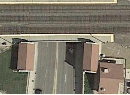
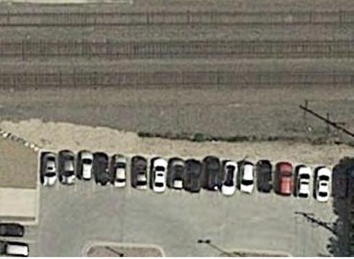
6 2. Existing Neighborhood Conditions Transportation conditions were inventoried to obtain a database for evaluating the existing operations within the neighborhood and along the roadways bordering the neighborhood. The components of existing conditions that were inventoried within the neighborhood included the following: Existing land uses Physical and operating characteristics of the roadways (i.e., number of lanes, speed limits, traffic control, etc.) Existing traffic control devices Existing pedestrian and bicycle facilities Existing daily traffic volumes and vehicle speeds Existing morning and evening peak hour volumes Study Area and Existing Land Uses The neighborhood is generally bounded by Ogden Avenue, Henry Puffer Elementary School, and the Downers Grove Golf Club on the north, Belmont Road and the Downers Grove Golf Club on the east, Burlington Avenue on the south, and Walnut Avenue on the west. Located along the western boundary of the Village, single-family homes are the predominant land use within the neighborhood with some commercial and office land uses located along Ogden Avenue. The neighborhood contains Henry Puffer Elementary School, which is located in the northwest quadrant of the Belmont Road/Haddow Avenue intersection, and the Belmont Prairie Nature Preserve and Walnut Park, which are located in the western portion of the neighborhood. In addition, the Belmont Metra train station and a parking lot for the train station are located in the southeast portion of the neighborhood. Finally, the Downers Grove Golf Club is located adjacent to the neighborhood with access provided via Haddow Avenue. Neighborhood 5 Traffic Study 2
7 Existing Roadway System The two external roadways that border the neighborhood are described below. Ogden Avenue (U.S. Route 34) is a northeast-to-southwest road that is under the jurisdiction of the Illinois Department of Transportation (IDOT). It has a five-lane cross section with a posted speed limit that varies from 35 mph to 40 mph. Traffic signal control is provided at its intersections with Belmont Road, Cross Street, and the I-355 ramps. IDOT classifies Ogden Avenue as a major arterial. Belmont Road is a north-south roadway that is under the jurisdiction of the DuPage County Division of Transportation (DuDOT). In general, Belmont Road has a four-lane cross section and a posted speed limit of 35 mph. Separate left-turn lanes are provided on Belmont Road at its signalized intersections with Ogden Avenue, Prairie Avenue, and Haddow Avenue. Belmont Road has a grade-separated intersection with Burlington Avenue. IDOT classifies Belmont Road as a minor arterial. Internal Neighborhood Roadways Excluding Ogden Avenue and Belmont Road, the following summarizes the physical and operating characteristics of the neighborhood roadways. All of the neighborhood roads provide one lane in each direction. All of the roadways within the neighborhood are classified as local roads except Walnut Avenue and Burlington Avenue, which are classified as collector roads. Parking is generally provided on one or both sides of the roadways except Rose Avenue, Western Avenue, and the western section of Burlington Avenue. However, parking restrictions are provided on many of the roadways. In addition, perpendicular commuter parking is provided along the south side of the eastern section of Burlington Avenue. The posted speed limit within the neighborhood is 25 miles per hour with 20 mph school and park zone speed limits except Walnut Avenue and Burlington Avenue, which have a posted speed limit of 30 mph. Figure 2 illustrates the number of lanes and posted speed limits on each of the roadways and the geometrics at the primary intersections. Figure 3 shows the parking restrictions in the neighborhood. Neighborhood 5 Traffic Study 3
8 Pedestrian and Bicycle Facilities and Traffic Control Devices The neighborhood contains Henry Puffer Elementary School, Downers Grove Golf Club, Belmont Prairie Nature Preserve, Walnut Park, and the Belmont Metra train station. In order to accommodate the neighborhood pedestrian and bicycle activity, a number of facilities and traffic control devices are provided in the neighborhood. These are illustrated in Figure 4 and highlighted below: Burlington Avenue between Belmont Road and Cross Street and Cross Street are designated bike routes. Dedicated school crossings are provided at the intersections of Belmont Road with Prairie Avenue and Haddow Avenue with Puffer Road. School zones with warning signs and reduced speed limits are located along Belmont Road and Haddow Avenue within proximity to Henry Puffer Elementary School. School crossing guards are stationed at the Belmont Road with Prairie Avenue intersection. A dedicated pedestrian crossing is provided at the intersection of Haddow Avenue with Edward Avenue and the Downers Grove Golf Club access drive. All of the traffic signals provide pedestrian signals. Sidewalks are provided on at least one side of all the following roadways: o o o o o Burlington Avenue Haddow Avenue Puffer Road Chase Avenue Edward Avenue In order to determine the pedestrian activity around the school, pedestrian counts were conducted at the intersection of Belmont Road with Haddow Avenue. The counts were conducted in November 2016 from 7:00 A.M. to 9:00 A.M. and from 2:00 P.M. to 4:00 P.M. Figure 4 also illustrates the results of the pedestrian traffic counts. Neighborhood 5 Traffic Study 4
9 Existing Intersection Traffic Control Figure 5 shows the existing intersection traffic control within the neighborhood and the following provides a summary of the existing traffic control at the 28 intersections within the neighborhood: One intersection is under traffic signal control Two intersections are under all-way stop sign control Nine intersections are under two-way or one-way stop sign control One intersection has two of the three legs under stop sign control Fifteen intersections have no intersection traffic control Existing Daily Traffic Volumes and Speed Surveys In order to determine the existing traffic volumes and speeds along the neighborhood roadways, KLOA, Inc. conducted daily machine traffic counts and speed surveys at 20 locations. Of the total traffic counts and speed surveys, 12 were conducted along the north-south roadways and eight were conducted along the east-west roadways. The KLOA, Inc. traffic counts and speed surveys were conducted during October All of the traffic counts and speed surveys were conducted for a minimum of two days and were broken down by direction and by hour. Figure 6 shows the two-way daily traffic volumes and Figure 7 shows the average and 85 th percentile speeds observed on the roadways. The average speed is the sum of the observed speeds of all the vehicles divided by the total vehicles on that segment of the road. Average speeds are used to determine the speeds at which motorists are typically traversing a roadway section, whereas the 85 th percentile speed represents the speed at or below which 85 percent of vehicles on a roadway section travel under free flow conditions. The 85 th percentile speed is commonly used to establish the posted speed limits along roadways. Existing Morning and Evening Peak Period Traffic Volumes In addition to the daily traffic counts and speed surveys, KLOA, Inc. conducted manual peak period traffic counts at the following intersections within the study area: Cross Street with Ogden Avenue Cross Street with Haddow Avenue Haddow Avenue with Belmont Road Haddow Avenue with Puffer Road and the Henry Puffer Elementary School access drive The traffic counts were conducted in November 2016 during the morning (6:00 A.M. to 9:00 A.M.) and evening (3:00 P.M. to 6:00 P.M.) peak periods. Figure 8 illustrates the existing morning and evening peak hour traffic volumes. Neighborhood 5 Traffic Study 5
10 3. Evaluation of Existing Conditions To determine how the roadway system is currently functioning, KLOA, Inc. examined the existing operating characteristics within the neighborhood. The purpose of this evaluation was to identify and quantify the current operations and ascertain how the neighborhood s infrastructure and land uses contribute to the existing conditions. This was accomplished by reviewing and analyzing the existing traffic volumes and the speed surveys as well as the physical characteristics of the neighborhood and its transportation system. This evaluation provides the basis to thoroughly analyze and develop recommendations pertaining to the operation and design of the internal roadways. Daily Traffic Volumes From Figure 6, it can be seen that the collector roads (Walnut Avenue and Burlington Avenue) carry the highest volume of traffic. This is expected given that collector roads link the local neighborhood roads and land uses to the external or arterial roadway system. Further, the collector roads generally extend the length of the neighborhood and serve many homes and other land uses within the neighborhood. In addition, the eastern section of Haddow Avenue carries a higher volume of traffic which is due in part to the fact that it provides access to Henry Puffer Elementary School, the Downers Grove Golf Club, and the commuter parking lot. Residential Streets, Third Edition a indicates that local residential roads have a daily volume between 400 and 1,500 vehicles while residential collector roads have a daily volume exceeding 1,500 vehicles. Therefore, even with the characteristics outlined above, the traffic volumes within the neighborhood are generally within the established standards for residential roads. Overall, given the various non-residential land uses in the neighborhood, the traffic volumes are relatively low. a Residential Streets, Third Edition was developed by the National Association of Home Builders (NAHB), the American Society of Civil Engineers (ASCE), the Institute of Transportation Engineers (ITE), and the Urban Land Institute (ULI). Neighborhood 5 Traffic Study 6
11 A review of the existing traffic volumes as well as the roadway system s physical and operating conditions indicates that the neighborhood is likely experiencing some limited cut-through traffic along Walnut Avenue, Burlington Avenue, and to a lesser extent along Haddow Avenue and Cross Street. The cut-through traffic can be attributed to the congestion along Ogden Avenue and its intersection with Belmont Road. However, as indicated previously, the traffic volumes in the neighborhood are low and well within the established standards for residential roads. Travel Speed Surveys The main factors affecting travel speeds are the roadway s physical and operating characteristics including width of road, number of travel lanes, hills, curves, roadway surface, and length of free-flow conditions. Many of these attributes are fixed within the neighborhood s infrastructure and are generally difficult and/or costly to change. Excluding Walnut Avenue and Burlington Avenue which have 30 mph posted speed limits, the internal neighborhood roads had an observed average speed of approximately 20 mph and an observed 85 th percentile speed of approximately 26 mph. As shown in Figure 7, the average speeds on the roads with a posted 25 mph speed limit were generally between 14 and 29 mph. A number of the surveyed road sections did experience 85 th percentile speeds that exceeded the posted speed limit by five mph and were primarily observed along the collector roads and those roadway sections that had longer lengths of free-flow conditions. The speed surveys show that the following roadways had 85 th percentile speeds that exceeded the posted speed limit by five mph: Walnut Avenue Burlington Avenue Haddow Avenue Dressel Road Neighborhood 5 Traffic Study 7
12 4. Detailed Evaluation and Recommendations This section of the study provides the detailed evaluation of the internal roadways, pedestrian and bicycle facilities, and traffic control devices within the neighborhood and included a thorough analysis of traffic operations, vehicular and pedestrian/bicycle circulation, and overall safety along the internal neighborhood roadways. Recommendations were developed for the following components of the neighborhood transportation system: Intersection Traffic Control Devices Pedestrian and Bicycle Facilities In addition, a number of traffic calming measures and/or tools were identified that can be used to effectively reduce the operating speeds and traffic volumes in the neighborhood. The recommendations developed in this section were based primarily on accepted engineering practices, conformity with the 2009 Manual on Uniform Traffic Control Devices (MUTCD), existing Village criteria, and the input from Village staff. The MUTCD defines the standards used to install and maintain traffic control devices, including all signs, signals, markings, and other devices used to regulate, warn, or guide traffic on all public streets, highways, bikeways, and private roads open to public traffic. While the MUTCD provides guidelines with specific benchmarks, many of the criteria are subjective and are left to engineering judgment and practices. Neighborhood 5 Traffic Study 8
13 Intersection Traffic Control Development of the intersection traffic control plan involves a comprehensive evaluation of each intersection along with the existing overall operating conditions of the neighborhood (see Chapter 3). Any intersection traffic control plan must consider typical neighborhood issues, such as functional classifications, cut-through traffic, speeding, traffic calming, neighborhood circulation, and land-use impacts. As such, a systematic approach was employed that examined the neighborhood from the inside (each individual intersection) and outside (the overall neighborhood). It is important to note that to increase the level of standardization and consistency of the neighborhood traffic control, the Village has requested that traffic signal control or some form of stop sign control generally be provided at all of the neighborhood intersections. The first step consisted of evaluating the physical and operating conditions of each intersection to determine if they meet any of the MUTCD warrants/requirements that control the installation of all-way stop sign control. The second step was to determine which road of the one-way and two-way controlled intersections is to be under stop sign control. Figure 9 illustrates the proposed traffic control plan which is presented below. All-Way Stop Sign Controlled Intersections The following points summarize the all-way stop sign control warrants/requirements as outlined in the MUTCD: 1. Meets the minimum traffic and pedestrian volume 2. Meets the minimum number of intersection crashes 3. Required to control left-turn conflicts 4. Required to control vehicle/pedestrian conflicts 5. Required due to poor intersection sight distance 6. Required to improve traffic operational characteristics of the intersection of two collector roads with similar design and operating characteristics The characteristics of each intersection were evaluated to verify whether the existing operations met any of the warrants and/or requirements that control the installation of an all-way stop sign control. It has been determined that the following intersections should be under all-way stop sign control: Warren Avenue with the Belmont Road West Ramp. This intersection should continue to operate under all-way stop sign control as it is the intersection of a collector roadway and the ramp from an arterial road. Warren Avenue with the Belmont Road East Ramp. This intersection should be converted to all-way stop sign control, given that it is an intersection of a collector roadway and the ramp from an arterial road. Neighborhood 5 Traffic Study 9
14 Haddow Avenue with Cross Street. This intersection should continue to operate under all-way stop sign control to maintain this established location and to reduce the uninterrupted flow along Cross Street. Haddow Avenue with Edward Avenue and the Downers Grove Golf Club Access Drive. This intersection should be converted to all-way stop sign control, given the uninterrupted flow along Haddow Avenue as well as the pedestrian activity in proximity to the intersection. Two-Way/One-Way Stop Sign Controlled Intersections Once the all-way stop sign control intersections were identified, it was assumed that all of the other intersections were to be controlled via one-way (T-intersections) or two-way (four-legged intersections) stop sign control. The criteria used in determining which road of an intersection should be under stop sign control were based on the following: 1. The guidelines provided in the MUTCD. 2. Minimizing the uninterrupted flow along the local road by providing, if possible, a stop sign at every other cross road along the local roads. 3. If possible, maintaining which road is currently under traffic control (via either yield sign or stop sign) at each intersection in order to minimize the change in the flow of traffic through the neighborhood. New Two-Way Stop Sign Controlled Intersections New two-way stop sign control should be provided at the following intersections: Cross Street with Indianapolis Avenue and Drendel Road with Indianapolis Avenue. Both of these intersections currently operate with no intersection traffic control. The Indianapolis Avenue approaches should be under stop sign control at both intersections. Francisco Avenue with Haddow Avenue. This intersection currently operates with no intersection traffic control. The Francisco Avenue approaches should be under stop sign control at this intersection. Neighborhood 5 Traffic Study 10
15 Proposed One-Way Stop Sign Controlled Intersections The following T-intersections currently have no control and should be converted so the minor approaches are under stop sign control: Rose Avenue with Haddow Avenue and Rose Avenue with Burlington Avenue. The Rose Avenue approaches should be under stop sign control at both intersections. Western Avenue with Haddow Avenue and Western Avenue with Burlington Avenue. The Western Avenue approaches should be under stop sign control at both intersections. Chase Avenue with Haddow Avenue and Chase Avenue with Burlington Avenue. The Chase Avenue approaches should be under stop sign control at both intersections. Edward Avenue with Burlington Avenue. The Edward Avenue approach should be under stop sign control at this intersection. Francisco Avenue with Burlington Avenue. The Francisco Avenue approach should be under stop sign control at this intersection. Cross Street with Burlington Avenue. The Cross Street approach should be under stop sign control at this intersection. Drendel Road with Burlington Avenue. The Drendel Road approach should be under stop sign control at this intersection. Granville Avenue with Burlington Avenue. The Granville Avenue approach should be under stop sign control at this intersection. Walnut Avenue with Provence Court. The Provence Court approach should be under stop sign control at this intersection. Finally, Cross Street currently has an S-curve in its alignment that has limited sight distance and a narrow cross section. As such, to provide for a safer and more orderly flow of traffic through the S-curve, stop signs should be installed along both legs of the S-curve. Neighborhood 5 Traffic Study 11
16 Summary of Recommended Intersection Traffic Control Plan Table 1 provides a summary of the intersection traffic control modifications and Table 2 provides a comparison of the existing and recommended traffic control within the neighborhood. Under the recommended plan, 28 of the 28 intersections will be under either traffic signal control or some form of stop sign control. This is an improvement over existing conditions where 15 intersections have no intersection traffic control. Table 1 RECOMMENDED INTERSECTION TRAFFIC CONTROL MODIFICATIONS Modifications Convert two-way stop sign control to all-way stop sign control Convert intersection with two of three legs under stop sign control to all-way stop sign control Add two-way stop sign control at intersections with no intersection traffic control Add one-way stop sign control at intersections with no intersection traffic control Intersections Haddow Avenue at Edward Avenue and Downers Grove Golf Club Access Drive Burlington Avenue with Belmont Road East Ramp Drendel Road at Indianapolis Avenue (Stop sign control on Indianapolis Ave.) Cross Street at Indianapolis Avenue (Stop sign control on Indianapolis Ave.) Haddow Avenue at Francisco Avenue (Stop sign control on Francisco Avenue) Burlington Avenue at Chase Avenue Burlington Avenue at Edward Avenue Burlington Avenue at Western Avenue Burlington Avenue at Rose Avenue Burlington Avenue at Francisco Avenue Burlington Avenue at Cross Street Burlington Avenue at Drendel Road Burlington Avenue at Granville Avenue Haddow Avenue at Chase Avenue Haddow Avenue at Western Avenue Haddow Avenue at Rose Avenue Walnut Avenue at Provence Court Add stop sign control along roadway Cross Street S-Curve Neighborhood 5 Traffic Study 12
17 Table 2 EXISTING AND RECOMMENDED INTERSECTION TRAFFIC CONTROL Existing Intersection Traffic Control Recommended Intersection Traffic Control Traffic Signal Control 1 1 All-Way Stop Sign Control 2 4 Two-Way/One-Way Stop Sign Control 9 23 Two of Three Legs Under Stop Sign Control 1 0 No Intersection Traffic Control 15 0 Total Pedestrian and Bicycle Facilities and Traffic Control Devices As discussed previously, the neighborhood contains several pedestrian- and bicycle-generating land uses, including the Belmont Metra train station, Henry Puffer Elementary School, Downers Grove Golf Club, Walnut Park, and Belmont Prairie Nature Preserve. In addition, the Downers Grove Park District is proposing a soccer complex in the northwest section of the neighborhood. As such, the neighborhood has a number of existing and proposed land uses that generate higher pedestrian and bicycle activity. In addition to the standard pedestrian and bicycle facilities (i.e., sidewalks, crosswalks and bike routes), the neighborhood contains various traffic control devices associated with the nonresidential land uses. The neighborhood has several dedicated school and pedestrian crossings and school zones, which include appropriate warning signs and reduced speed limits. In addition, the traffic signals at the intersections of Belmont Road with Haddow Avenue and Belmont Road with Prairie Avenue have countdown pedestrian signals. Overall, these traffic control devices are generally well distributed and located appropriately. Neighborhood 5 Traffic Study 13
18 However, recommendations have been developed to further enhance the pedestrian and bicycle circulation and to ensure that the traffic control devices comply with the MUTCD. The proposed recommendations are illustrated in Figure 10 and summarized below and in Table 3: Sidewalks are currently provided on one side of the following roads in the neighborhood: o o o o o North side and a portion of the south side of Burlington Avenue North side of Haddow Avenue West side of Edward Avenue West side of Chase Avenue East side of Puffer Avenue To accommodate the neighborhood pedestrian activity, the Village should strive to install sidewalks or multi-use paths on at least one side of all the roads in the neighborhood. This is particularly critical given the narrow widths of many of the roads. To further enhance pedestrian and bicycle access to and from and circulation around the neighborhood as well as the nature preserve and the proposed soccer complex, the Village should explore whether sidewalks/multi-use paths can be provided through undeveloped Village right-of-ways and/or the nature preserve property. High visibility ladder style crosswalks should be installed at all of the existing and future pedestrian crossings within the neighborhood. An Advanced School Crossing Assembly should be installed along the eastbound direction of Haddow Avenue in advance of the existing school crossing at the intersection of Haddow Avenue with Puffer Road. Consideration should be given to installing sharrow markings along the two designated bike routes (Cross Street and Burlington Avenue between Belmont Road and Cross Street) in the neighborhood. Sharrow markings reinforce the shared-lane environment of posted bicycle routes where the road width cannot support dedicated bicycle lanes and/or where it is undesirable to eliminate on-street parking. Additionally, they alert road users of the lateral position that bicyclists are likely to occupy within the road to keep them out of the door zone of parked cars and in lanes that are too narrow for a motor vehicle and a bicycle to travel side-by-side within the same traffic lane. Further, they may reduce the number of bicyclists on the sidewalks and the additional guidance may reduce the number of bicyclists riding on the wrong side of the road. Neighborhood 5 Traffic Study 14
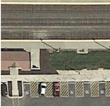
19 Consideration should be given to installing the following pedestrian enhancements at the Belmont Metra train station (see Figure 11) to improve pedestrian safety and increase the number of pedestrian crossings: o o Burlington Avenue with Belmont Road West Ramp. A curb/sidewalk extension should be considered on the south side of the pedestrian crossing along the west leg of the intersection. The curb/sidewalk extension should extend the length of the perpendicular parking provided along the south side of Burlington Avenue. In addition, a high visibility ladder style crosswalk should be installed on the north leg of the intersection. Burlington Avenue with Belmont Road East Ramp. Given that this intersection is proposed to operate under all-way stop sign control, consideration should be given to installing a pedestrian crossing on the west leg of the intersection. If installed, the pedestrian crossing should include a high visibility ladder style crosswalk and a curb/sidewalk extension on the south side of the crossing. The curb/sidewalk extension should extend the length of the perpendicular parking provided along the south side of Burlington Avenue. In addition, a high visibility ladder style crosswalk should be installed on the north leg of the intersection. However, further studies should be conducted to determine any impacts the enhancements will have on the Belmont Metra train station and the feasibility of installing the enhancements. Consideration should be given to installing a pedestrian refuge island in the Belmont Road median serving the crosswalk along the south leg of the Belmont Road with Prairie Avenue intersection (see Figure 12). However, in order to accommodate the turning maneuver of a semi-trailer, the crosswalk and sidewalk ramps on the south leg of the intersection and the northbound stop bar would need to be relocated approximately 15 feet south of their current location. As such, a comprehensive study needs to be performed in order to determine the impacts and feasibility of installing the pedestrian refuge island and the other require intersection modifications. Further, any improvements will require the review and approval of DuDOT as they have jurisdiction over Belmont Road. Neighborhood 5 Traffic Study 15
20 Table 3 RECOMMENDED PEDESTRIAN AND BICYCLE FACILITIES AND TRAFFIC CONTROL ENHANCEMENTS Enhancement Install sidewalks/multi-use path on at least one side of the neighborhood roads Location All of the neighborhood roads without sidewalks Install ladder style crosswalks Burlington Avenue at Belmont Road West Ramp Burlington Avenue at Belmont Road East Ramp Burlington Avenue at Puffer Road Burlington Avenue at Chase Avenue Burlington Avenue at Edward Avenue Burlington Avenue at Western Avenue Burlington Avenue at Rose Avenue Burlington Avenue at Francisco Avenue Burlington Avenue at Cross Street Burlington Avenue at Drendel Road Burlington Avenue at Granville Avenue Haddow Avenue at Puffer Elementary School Access Drive Haddow Avenue at Downers Grove Golf Club Access Drive Install Advanced School Crossing Assembly Haddow Avenue at Puffer Road Install sharrow markings on designated bike routes Install curb/sidewalk extension (Only after comprehensive study is performed to determine impacts/feasibility) Install pedestrian refuge island (Only after comprehensive study is performed to determine impacts/feasibility) Burlington Avenue between Belmont Road and Cross Street Cross Street Burlington Avenue at Belmont Road West Ramp Burlington Avenue at Belmont Road East Ramp South leg of Belmont Road with Prairie Avenue intersection Neighborhood 5 Traffic Study 16
21 Traffic Calming Measures Speeding and cut-through traffic are generally two of the major concerns expressed by residents in any neighborhood. As discussed previously, the traffic volumes within the neighborhood are generally within an acceptable range for residential roads and consistent with traffic patterns on other neighborhood roads within the Village. Furthermore, the internal neighborhood roads generally had observed average speeds within one to two mph of the posted speed limit and observed 85 th percentile speeds within five mph of the posted speed limit. Several of the roads did experience 85 th percentile speeds that exceeded the speed limit by five mph or more. The higher 85 th percentile speeds were primarily observed along those roadway sections that had longer lengths of free-flow conditions. As such, a review of the existing traffic volumes and speed surveys as well as the roadway system s physical and operating conditions indicates that the neighborhood is experiencing some higher travel speeds and cut-through traffic. The recommended traffic control and striping modifications should help to mitigate the speeds and cut-through traffic in the neighborhood. If these measures are not completely successful, other measures and/or tools that can effectively reduce vehicle speeds and cut-through traffic include the following traffic calming measures: Enhanced speed limit signs that increase motorists awareness Increased police enforcement Portable or permanent speed awareness systems such as electronic speed radar signs Pavement markings, edge lines, parking lanes, and bike lanes/sharrows that reduce the width of roadways Horizontal or vertical deflections (e.g. curb extensions and/or medians at intersections and midblock locations, traffic circles, raised crosswalks, chokers, neck-downs, and chicanes) Table 4 provides a summary of these measures/devices and also shows how they can be implemented incrementally from measures/devices with lower costs and reduced design, coordination, and implementation efforts to measures/devices with higher costs and greater design, coordination, and implementation efforts. Neighborhood 5 Traffic Study 17
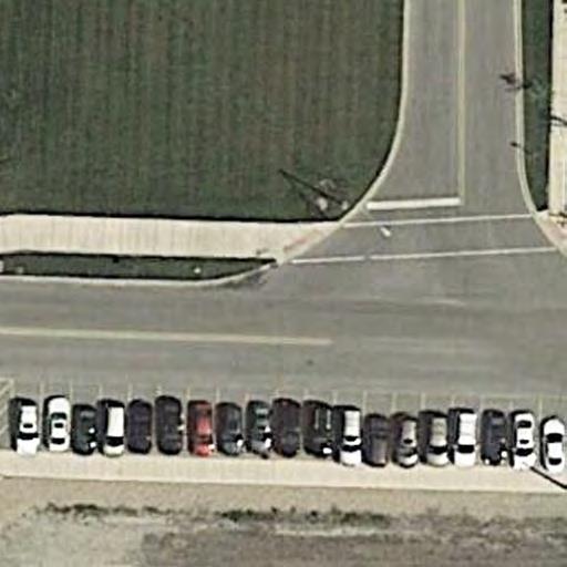
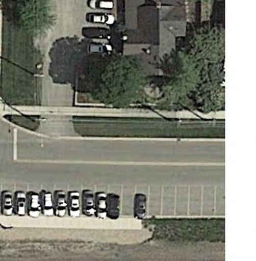
22 Table 4 INCREMENTAL TRAFFIC CALMING MEASURES Options Level 1 Regulatory Modifications Increased Police Presence/Enforcement Level 2 Advisory Signing Pavement Markings Level 3 Horizontal Deflections Vertical Deflections Examples Speed Limit Reductions Portable Speed Radar Signs, Enhanced Speed Limit Signs Parking Lanes, Bike Lanes/Sharrows, Crosswalks, Edgelines Curb Extensions, Medians, Traffic Circles, Chicanes, Chokers/Neck-Downs Raised Crosswalks, Speed Humps, Speed Tables, Speed Cushions In addition, KLOA, Inc. examined locations that would be appropriate for traffic calming measures and developed traffic calming recommendations for the Village to consider. The review was only preliminary in nature and based on the existing traffic volumes, speed surveys, and roadway characteristics. Before any horizontal deflection measures are implemented, a thorough evaluation will need to be conducted to examine the impact of the measures/devices including emergency vehicle access and response times, diversion of traffic to other neighborhood roads, drainage impacts, costs, and long-term maintenance. The following outlines traffic calming measures that could be implemented along several of the neighborhood roads. Burlington Avenue Burlington Avenue is an east-west collector road that extends along the south end of the study area and has a grade-separated interchange with Belmont Road and serves the Belmont Metra train station. The road has one lane in each direction with perpendicular parking for the Belmont Metra train station provided on the south side of the road between Pershing Avenue and Rose Avenue. It is under all-way stop sign control at its intersection with the Belmont Road west ramp and is proposed to be under all-way stop sign control at its intersection with the Belmont Road east ramp. According to the daily traffic counts/speed surveys, Burlington Avenue had a daily traffic volume of 1,305 to 1,787 vehicles and 85 th percentile speed of 34 to 39 mph. The following traffic calming measures should be considered along Burlington Avenue: Center Line. Refresh the existing center line and extend to Walnut Avenue to delineate the travel lanes and to give motorists the perception of a narrower roadway. Neighborhood 5 Traffic Study 18
23 Speed Limit Signage/Markings. Add additional speed limits signs, install yellow-framed speed limit signs, and/or install speed limit pavement markings to further reinforce the posted speed limit. Speed Monitors and Police Enforcement. Utilize portable electronic speed monitors and/or install permanent speed monitors to further reinforce the posted speed limit. In addition, enhance targeted police enforcement, particularly during the weekday morning (7:00-9:00 A.M.) and evening (4:00-7:00 P.M.) peak commuting hours. Sharrow Markings. Install sharrow markings along both directions of the road between Belmont Road and Cross Street to reinforce the shared-lane environment of the posted bicycle route. Median Islands. Install a median island along the sections with no on-street parking to give motorists the perception of a narrower roadway that will reduce travel speeds. Walnut Avenue Walnut Avenue is a north-south collector road that extends along the west end of the study area from Ogden Avenue to Burlington Avenue and serves Walnut Park and Belmont Prairie Nature Preserve. The road has one lane in each direction with parking permitted on both sides of the road. It is under stop sign control at its intersection with Ogden Avenue. According to the daily traffic counts/speed surveys, Walnut Avenue had a daily traffic volume of 1,298 to 1,747 vehicles and 85 th percentile speed of 35 to 41 mph. The following traffic calming measures should be considered along Walnut Avenue: Speed Limit Signage/Markings. Add additional speed limits signs, install yellow-framed speed limit signs, and/or install speed limit pavement markings to further reinforce the posted speed limit. Speed Monitors and Police Enforcement. Utilize portable electronic speed monitors and/or install permanent speed monitors to further reinforce the posted speed limit. In addition, enhance targeted police enforcement, particularly during the weekday morning (7:00-9:00 A.M.) and evening (4:00-7:00 P.M.) peak commuting hours. Median Islands. Install one or more median islands to give motorists the perception of a narrower roadway that will reduce travel speeds. This would require the elimination of on-street parking within proximity to the median islands. Neighborhood 5 Traffic Study 19
24 Haddow Avenue Haddow Avenue is an east-west local road that extends between Belmont Road and Cross Street and provides access to Henry Puffer Elementary School and Downers Grove Golf Club. The road has one lane in each direction with parking generally permitted on both sides of the road. It is under traffic signal control at its intersection with Belmont Road and all-way stop sign control at its intersection with Cross Street. In addition, the road is recommended to be under all-way stop sign control at its intersection with Edward Avenue and the Downers Grove Golf Club access drive. According to the daily traffic counts/speed surveys, Haddow Avenue had a daily traffic volume of 491 to 1,503 vehicles and 85 th percentile speed of mph. The following traffic calming measures should be considered along Haddow Avenue: Speed Limit Signage/Markings. Add additional speed limits signs, install yellow-framed speed limit signs, and/or install speed limit pavement markings to further reinforce the posted speed limit. Speed Monitors and Police Enforcement. Utilize portable electronic speed monitors and/or install permanent speed monitors to further reinforce the posted speed limit. In addition, enhance targeted police enforcement, particularly during the weekday morning (7:00-9:00 A.M.) and evening (4:00-7:00 P.M.) peak commuting hours. Median Islands. Install a median island at the intersection with Edward Avenue and the Downers Grove Golf Club access drive to enhance pedestrian circulation and safety and give motorists the perception of a narrower roadway that will reduce travel speeds. Neighborhood 5 Traffic Study 20
25 5. Conclusion This study summarizes the results and findings of the neighborhood traffic study for Area Number 5. The neighborhood is generally bounded by Ogden Avenue, Henry Puffer Elementary School, and the Downers Grove Golf Club on the north, Belmont Road and the Downers Grove Golf Club on the east, Burlington Avenue on the south, and Walnut Avenue on the west. Overall, the objective of the study was to thoroughly examine the existing traffic operations within the neighborhood, identify operational deficiencies, and recommend modifications and/or improvements to enhance both vehicular and pedestrian operations. The study addressed the primary traffic concerns within any neighborhood: vehicular volume, vehicular speed, and overall vehicular and pedestrian safety. The recommendations developed in the study were based primarily on accepted engineering practices, conformity with the 2009 MUTCD, existing Village criteria, and the input from Village staff and residents. Tables 5, 6, and 7 summarize the short-term, mid-term, and long-term recommendations of the neighborhood traffic study. Short-term improvements generally have lower costs, are easier to implement, and/or are needed to address immediate concerns. Long-term improvements are generally more costly, require additional planning/engineering, can be implemented with other improvement projects, or may only be required depending on the effectiveness of previous efforts. Neighborhood 5 Traffic Study 21
26 Table 5 SHORT-TERM (0 TO 6 MONTHS) RECOMMENDATIONS Recommendations Intersection Traffic Control Modifications Convert two-way stop sign control to all-way stop sign control Convert intersection with two of three legs under stop sign control to all-way stop sign control Add two-way stop sign control at intersections with no intersection traffic control Add one-way stop sign control at intersections with no intersection traffic control Location Haddow Avenue at Edward Avenue and Downers Grove Golf Club Drive Burlington Avenue with Belmont Road East Ramp Drendel Road at Indianapolis Avenue (Stop sign control on Indianapolis Ave.) Cross Street at Indianapolis Avenue (Stop sign control on Indianapolis Ave.) Haddow Avenue at Francisco Avenue (Stop sign control on Francisco Avenue) Burlington Avenue at Chase Avenue Burlington Avenue at Edward Avenue Burlington Avenue at Western Avenue Burlington Avenue at Rose Avenue Burlington Avenue at Francisco Avenue Burlington Avenue at Cross Street Burlington Avenue at Drendel Road Burlington Avenue at Granville Avenue Haddow Avenue at Chase Avenue Haddow Avenue at Western Avenue Haddow Avenue at Rose Avenue Walnut Avenue at Provence Court Add stop sign control along roadway Cross Street S-Curve Neighborhood 5 Traffic Study 22
27 Table 5, Continued SHORT-TERM (0 TO 6 MONTHS) RECOMMENDATIONS Recommendations Location Pedestrian and Bicycle Enhancements Install ladder style crosswalks Burlington Avenue at Belmont Road West Ramp Burlington Avenue at Belmont Road East Ramp Burlington Avenue at Puffer Road Burlington Avenue at Chase Avenue Burlington Avenue at Edward Avenue Burlington Avenue at Western Avenue Burlington Avenue at Rose Avenue Burlington Avenue at Francisco Avenue Burlington Avenue at Cross Street Burlington Avenue at Drendel Road Burlington Avenue at Granville Avenue Haddow Avenue at Puffer Elementary School Access Drive Haddow Avenue at Downers Grove Golf Club Access Drive Install Advanced School Crossing Assembly Haddow Avenue at Puffer Road Traffic Calming Measures Increase police awareness/enforcement Throughout the neighborhood Refresh the existing center line and extend to Burlington Avenue Walnut Avenue Install additional speed limits signs, install yellow-framed speed limit signs, and/or install speed limit pavement markings Burlington Avenue Walnut Avenue Haddow Avenue Neighborhood 5 Traffic Study 23
28 Table 6 MID-TERM (6 TO 18 MONTHS) RECOMMENDATIONS Recommendations Location Pedestrian and Bicycle Enhancements Install sharrow markings Burlington Avenue between Belmont Road and Cross Street Cross Street Traffic Calming Measure Install portable/permanent speed radar signs (Only implement if objectives of other measures are not sufficiently met.) Key areas in the neighborhood, including Burlington Avenue Walnut Avenue Haddow Avenue Table 7 LONG-TERM (18 TO 36 MONTHS) RECOMMENDATIONS Recommendations Location Pedestrian and Bicycle Enhancements Install curb/sidewalk extension (Only after comprehensive study is performed to determine impacts/feasibility) Install pedestrian refuge island (Only after comprehensive study is performed to determine impacts/feasibility) Traffic Calming Measure Install median islands (Implement only if objectives of other measures are not sufficiently met and a thorough evaluation of the impact of the measures/devices are performed.) Burlington Avenue at Belmont Road East Ramp Burlington Avenue at Belmont Road West Ramp South leg of Belmont Road with Prairie Avenue intersection Possible locations for consideration include: Burlington Avenue Walnut Avenue Haddow Avenue Neighborhood 5 Traffic Study 24
29 Neighborhood 5 Traffic Study Appendix
30 Figure 1 Aerial View of Study Area Neighborhood 5 Traffic Study
31 TOLLW AY ACCESS DRIVE AUTHOR T I Y DR V I E PEDIATRICIAN MCDONALDS 40 FARMERS INSURANCE 1 25 CROSS ZEIGLER PRE-OWNED 35 BELM ONT N NOT TO SCALE GRANT XX SCHOOL 20 1 LEGEND OGDEN - TRAVEL LANE - TRAFFIC SIGNAL - SPEED LIMIT - BUS STOP - NO LEFT TURN - SCHOOL SPEED LIMIT SIGN - 4 LANE WAY - 5 LANE WAY - 2 LANE WAY - WEIGHT LIMIT 6 TONS EXCEPT LOCAL DELIVERIES POSTED OTHERWISE UNLESS 25 COURT W ALNUT 30 PROVENCE WALNUT PARK GRAINGER INDUSTRIAL NY PIZZA PIE SUPPLY HONEY CUTS CHIROPRACTOR STRICTLY VAPE RENTAL MAX NATIONAL GUARD X-NAILS HERTZ 25 DRENDEL INDIANAPOLIS 15 MPH CROSS 25 DOWNERS GROVE GOLF CLUB PUFFER 20 SCHOOL 35 CHICAGO WALNUT CREEK APARTMENTS WALNUT CREEK 30 BELMONT PRAIRIE NATURE PRESERVE 15 MPH HENRY PUFFER SCHOOL ONE-W AY 30 PRAIRIE METRA BNSF RAILWAY BURLINGTON 30 GRANVILLE DRENDEL HADDOW FRANCISCO ROSE W ESTERN EDW ARD SCHOOL CHASE 25 ONE-WAY PUFFER SCHOOL EXIT SCHOOL 20 RAMP 20 RAMP METRA STATION 30 WARREN PROJECT: TITLE: Traffic Study Neighborhood 5 Downers Grove, Illinois EXISTING WAY CONDITIONS Job No: Figure: 2
32 TOLLW AY ACCESS DRIVE AUTHOR T I Y DR V I E CROSS BELM ONT N NOT TO SCALE GRANT OGDEN LEGEND - NO PARKING - 4 HOUR PARKING 6AM-6PM - NO PARKING 7AM-4PM - LOT G FREE AFTER 3PM, OVERNIGHT - LOT G FREE AFTER 3PM, NO PARKING 2AM-5AM - LOT G FREE AFTER 11PM, NO PARKING 2AM-5AM W ALNUT INDIANAPOLIS CHICAGO - LOT J, NO PARKING 2AM-5AM, FREE AFTER 3 PM B - BUS LOADING PROVENCE COURT DRENDEL CROSS PUFFER WALNUT CREEK PRAIRIE ONE-W AY HADDOW ONE-WAY METRA BNSF RAILWAY BURLINGTON GRANVILLE DRENDEL FRANCISCO ROSE W ESTERN EDW ARD PUFFER CHASE B METRA STATION WARREN PROJECT: TITLE: Traffic Study Neighborhood 5 Downers Grove, Illinois EXISTING PARKING RESTRICTIONS Job No: Figure: 3
33 TOLLW AY ACCESS DRIVE AUTHOR T I Y DR V I E CROSS BELM ONT N NOT TO SCALE GRANT LEGEND OGDEN 00 - AM PEAK HOUR (00) - AFTERNOON PEAK HOUR 00 (00) - PEDESTRIAN VOLUME - BIKE ROUTE - STANDARD CROSSWALK - CONTINENTAL CROSSWALK W ALNUT INDIANAPOLIS CHICAGO - CROSSING GUARD PROVENCE COURT DRENDEL CROSS PUFFER AHEAD AHEAD WALNUT CREEK 1 PRAIRIE 2 4 ONE-W AY 2 0 (0) METRA BNSF RAILWAY BURLINGTON GRANVILLE DRENDEL HADDOW FRANCISCO ROSE W ESTERN 3 4 EDW ARD 4 3 CHASE ONE-WAY 2 2 PUFFER (2) 0 (0) WARREN METRA STATION PROJECT: TITLE: Traffic Study Neighborhood 5 Downers Grove, Illinois EXISTING PEDESTRIAN AND BICYCLE FACILITIES AND TRAFFIC CONTROL DEVICES Job No: Figure: 4
34 TOLLW AY ACCESS DRIVE AUTHOR T I Y DR V I E CROSS BELM ONT N NOT TO SCALE GRANT OGDEN W ALNUT INDIANAPOLIS LEGEND - TRAFFIC SIGNAL CHICAGO - EXISTING STOP SIGN PROVENCE COURT DRENDEL CROSS PUFFER WALNUT CREEK PRAIRIE ONE-W AY HADDOW ONE-WAY METRA BNSF RAILWAY BURLINGTON GRANVILLE DRENDEL FRANCISCO ROSE W ESTERN EDW ARD CHASE PUFFER WARREN METRA STATION PROJECT: TITLE: Traffic Study Neighborhood 5 Downers Grove, Illinois EXISTING INTERSECTION TRAFFIC CONTROL Job No: Figure: 5
35 TOLLW AY ACCESS DRIVE AUTHOR T I Y DR V I E CROSS BELM ONT N NOT TO SCALE GRANT OGDEN W ALNUT 137 INDIANAPOLIS 166 LEGEND 00 - DAILY TRAFFIC BY DIRECTION CHICAGO PROVENCE COURT DRENDEL CROSS PUFFER WALNUT CREEK PRAIRIE ONE-W AY HADDOW ONE-WAY METRA BNSF RAILWAY BURLINGTON GRANVILLE DRENDEL FRANCISCO ROSE W ESTERN EDW ARD CHASE PUFFER WARREN METRA STATION PROJECT: TITLE: Traffic Study Neighborhood 5 Downers Grove, Illinois EXISTING DAILY TRAFFIC VOLUMES Job No: Figure: 6
36 TOLLW AY ACCESS DRIVE AUTHOR T I Y DR V I E CROSS BELM ONT N NOT TO SCALE GRANT OGDEN 35 (41) 33 (39) 24 (30) W ALNUT 24 (30) 22 (29) 22 (29) LEGEND 00 - AVERAGE SPEED (MPH) (00) - 85TH PERCENTILE SPEED (MPH) 20 (24) INDIANAPOLIS 18 (24) CHICAGO PROVENCE COURT DRENDEL CROSS PUFFER WALNUT CREEK 20 (26) 21 (25) ONE-W AY PRAIRIE METRA BNSF RAILWAY 33 (38) 30 (35) BURLINGTON GRANVILLE 33 (38) 33 (39) DRENDEL 21 (27) HADDOW 19 (26) 13 (19) FRANCISCO 13 (19) 11 (18) ROSE 12 (19) 12 (19) W ESTERN 14 (21) 31(37) 30 (36) 26 (33) 20 (28) EDW ARD 27 (32) 25 (31) 17 (26) 16 (23) CHASE 14 (22) ONE-WAY 20 (26) PUFFER 19 (25) 22 (28) 21 (26) 31(38) 30 (38) 29 (36) 29 (34) 29 (35) WARREN METRA STATION PROJECT: TITLE: Traffic Study Neighborhood 5 Downers Grove, Illinois EXISTING TRAVEL SPEED Job No: Figure: 7
37 TOLLW AY ACCESS DRIVE AUTHOR T I Y DR V I E 1911(1255) 10 (5) 4 (5) 20 (13) CROSS * 958 (1715) 0 (1) BELM ONT N NOT TO SCALE GRANT OGDEN LEGEND 00 - AM PEAK HOUR (00) - EVENING PEAK HOUR * - ILLEGAL MANEUVER W ALNUT INDIANAPOLIS CHICAGO PROVENCE COURT DRENDEL CROSS 77 (12) 44 (36) 14 (9) PUFFER WALNUT CREEK 3 (9) 13 (16) 28 (6) 77 (81) 15 (5) 5 (3) 24 (6) ONE-W AY PRAIRIE 28 (22) METRA BNSF RAILWAY BURLINGTON GRANVILLE DRENDEL 12 (11) 8 (6) HADDOW 2 (3) FRANCISCO ROSE W ESTERN EDW ARD CHASE ONE-WAY PUFFER 28 (36) 22 (92) 59 (28) 572 (1721) 95 (30) 1616 (825) WARREN METRA STATION PROJECT: TITLE: Traffic Study Neighborhood 5 Downers Grove, Illinois EXISTING INTERSECTION PEAK HOUR VOLUMES Job No: Figure: 8
38 TOLLW AY ACCESS DRIVE AUTHOR T I Y DR V I E CROSS BELM ONT N NOT TO SCALE GRANT OGDEN LEGEND - TRAFFIC CONTROL - EXISTING TRAFFIC CONTROL - PROPOSED TRAFFIC CONTROL W ALNUT INDIANAPOLIS CHICAGO PROVENCE COURT DRENDEL CROSS PUFFER WALNUT CREEK PRAIRIE ONE-W AY HADDOW ONE-WAY METRA BNSF RAILWAY BURLINGTON GRANVILLE DRENDEL FRANCISCO ROSE W ESTERN EDW ARD PUFFER CHASE WARREN METRA STATION PROJECT: TITLE: Traffic Study Neighborhood 5 Downers Grove, Illinois PROPOSED INTERSECTION TRAFFIC CONTROL Job No: Figure: 9
39 LEGEND 00 - AM PEAK HOUR (00) - AFTERNOON PEAK HOUR 00 (00) - PEDESTRIAN VOLUME - BIKE ROUTE TOLLW AY ACCESS DRIVE AUTHOR T I Y DR V I E CROSS BELM ONT N NOT TO SCALE GRANT - STANDARD CROSSWALK - CONTINENTAL CROSSWALK OGDEN - CROSSING GUARD - REMOVE STANDARD CROSSWALK - PROPOSED CONTINENTAL CROSSWALK - PROPOSED SIGN - PROPOSED SHARROW MARKINGS W ALNUT INDIANAPOLIS CHICAGO 1 AHEAD 3 AHEAD PROVENCE COURT DRENDEL CROSS PUFFER WALNUT CREEK 2 1 PRAIRIE ONE-W AY 2 0 (0) METRA BNSF RAILWAY BURLINGTON GRANVILLE DRENDEL HADDOW FRANCISCO ROSE W ESTERN EDW ARD CHASE ONE-WAY PUFFER 1 0 (2) 0 (0) WARREN METRA STATION PROJECT: TITLE: Traffic Study Neighborhood 5 Downers Grove, Illinois PROPOSED MODIFICATIONS TO THE PEDESTRIAN AND BICYCLE FACILITIES AND TRAFFIC CONTROL DEVICES Job No: Figure: 10


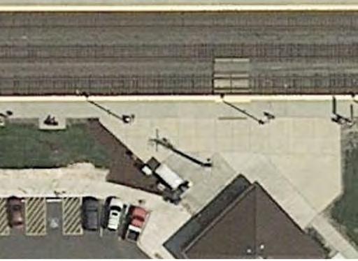
40 BELM ONT N NOT TO SCALE SIDEWALK EXTENSION SIDEWALK EXTENSION LADDER STYLE CROSSWALK NEW STOP SIGN AND STOP BAR LADDER STYLE CROSSWALKS BURLINGTON SIDEWALK EXTENSION PROJECT: TITLE: Traffic Study Neighborhood 5 Downers Grove, Illinois BURLINGTON AT BELMONT RAMPS CONCEPTUAL PEDESTRIAN ENHANCEMENTS Job No: Figure: 11


 PRAIRIE")

")


41 (c) 2016 Transoft Solutions, Inc. All rights reserved. N NOT TO SCALE WB-67 ILDOT 2014 (US) PRAIRIE SIDEWALK EXTENSION AND RAMP SIDEWALK EXTENSION AND RAMP WB-67 ILDOT 2014 (US) (c) 2016 Transoft Solutions, Inc. Al rights reserved. BELM ONT PROJECT: TITLE: Traffic Study Neighborhood 5 Downers Grove, Illinois BELMONT WITH PRAIRIE INTERSECTION CONCEPTUAL PEDESTRIAN REFUGE ISLAND Job No: Figure: 12
Neighborhood Traffic Study Area Number 4 Downers Grove, Illinois
 Neighborhood Traffic Study Area Number Downers Grove, Illinois Prepared for: Submitted by: Kenig, Lindgren, O Hara, Aboona, Inc. May 05 Neighborhood Traffic Study Area Number Downers Grove, Illinois Prepared
Traffic Circulation & Pedestrian Safety Study
 Lyons Township High School North Campus La Grange, Illinois Parking Lot Vaughan Building N Main Building Prepared for: Prepared by: July 23, 2015 Contents List of Figures, iii 1. Introduction...1 2. Existing
VILLAGE OF NILES TRAFFIC CALMING POLICY
 INTRODUCTION There is increasing interest across the country in developing new strategies to reduce the speed and amount of traffic in residential neighborhoods. Measurement of speeds, traffic volumes,
DEPARTMENT OF PUBLIC WORKS Carroll County, Maryland
 DEPARTMENT OF PUBLIC WORKS Carroll County, Maryland Prepared by the Bureau of Engineering 225 North Center Street, Room 221, Westminster, MD 21157 (410) 386-2157 e-mail: trafficcalming@ccg.carr.org http://ccgovernment.carr.org/trafficcalming
Town of Mooresville, North Carolina Neighborhood Traffic Calming and Control Device Policy
 Town of Mooresville, North Carolina Neighborhood Traffic Calming and Control Device Policy Adopted January 6, 2014 Town of Mooresville Development Services Department TOWN OF MOORESVILLE NEIGHBORHOOD TRAFFIC
Appendix C. TRAFFIC CALMING PROGRAM TOOLBOX
 Appendix C. TRAFFIC CALMING PROGRAM TOOLBOX PHASE I...2 Do Not Enter Sign...3 One-Way Sign...4 Turn Prohibition...5 Pavement Markings...6 Speed Monitoring Trailer...7 Neighborhood Speed Watch...8 Police
Residential Traffic Calming Program Guide. Town of Ashland, Virginia
 Residential Traffic Calming Program Guide Town of Ashland, Virginia August 1, 2006 TABLE OF CONTENTS A. INTRODUCTION... 1 B. GOALS... 1 C. CRITERIA... 1 D. IDENTIFYING NEIGHBORHOOD TRAFFIC CONCERNS...
TOWN OF CHAPEL HILL POLICY AND PROCEDURES FOR TRAFFIC CALMING MEASURES
 TOWN OF CHAPEL HILL POLICY AND PROCEDURES FOR TRAFFIC CALMING MEASURES (Adopted by the Town Council on June 30, 2004) (Revised December 6, 2010) (Revised February 8, 2016) POLICY AND PROCEDURES FOR TRAFFIC
Orange Center Elementary School
 Drag and drop pic and stretch/crop to the limits of the blue rectangle (delete this text box) Orange Center Elementary School Drag and drop pic and stretch/crop to the limits of the blue rectangle (delete
City of Elizabeth City Neighborhood Traffic Calming Policy and Guidelines
 City of Elizabeth City Neighborhood Traffic Calming Policy and Guidelines I. Purpose: The City of Elizabeth City is committed to ensure the overall safety and livability of residential neighborhoods. One
Peer Review of Highlands Neighborhood Traffic and Pedestrian Safety Plan
 FINAL REPORT March 14, 2017 Prepared for: Ada County Highway District Prepared by: SIX MILE ENGINEERING, PA Executive Summary The (Highlands Safety Plan) developed by the Ada County Highway District (ACHD)
Broad Street Bicycle Boulevard Design Guidelines
 Broad Street Bicycle Boulevard Design Guidelines Building from the strategies introduced in the 2013 Bicycle Transportation Plan and community input received thus far, City Transportation Staff have identified
Public Information Centre
 WELCOME Public Information Centre Father Tobin Road Lougheed Middle School - Library Wednesday November 7, 2012 7:00 p.m.to 9:00 p.m. Please sign in Neighbourhood Traffic Calming Guide Background The City
Meadow Woods Elementary School
 Drag and drop pic and stretch/crop to the limits of the blue rectangle (delete this text box) Meadow Woods Elementary School Drag and drop pic and stretch/crop to the limits of the blue rectangle (delete
County of Greenville South Carolina. Traffic Calming Program Neighborhood Traffic Education Program and Speed Hump Program
 County of Greenville South Carolina Traffic Calming Program Neighborhood Traffic Education Program and Speed Hump Program (rev) August 2008 I. PURPOSE The potential negative impacts from vehicular traffic
A plan for improved motor vehicle access on Railroad Avenue in Provincetown
 A plan for improved motor vehicle access on Railroad Avenue in Provincetown February 2011 A plan for improved motor vehicle access on Railroad Avenue in Provincetown INTRODUCTION AND PROBLEM IDENTIFICATION
TRAFFIC CALMING GUIDE FOR TORONTO CITY OF TORONTO TRANSPORTATION SERVICES DIVISION
 TRAFFIC CALMING GUIDE FOR TORONTO CITY OF TORONTO TRANSPORTATION SERVICES DIVISION CITY OF TORONTO TRANSPORTATION SERVICES DIVISION 2016 TRAFFIC CALMING GUIDE FOR TORONTO TABLE OF CONTENTS Introduction
Drag and drop pic and stretch/crop to the limits of the blue rectangle (delete this text box) Maxey Elementary School
 Maxey Elementary School") Drag and drop pic and stretch/crop to the limits of the blue rectangle (delete this text box) Maxey Elementary School SCHOOL ROUTE PLAN For MAXEY ELEMENTARY SCHOOL LOCATION 33 ORANGE COUNTY Prepared for:
Drag and drop pic and stretch/crop to the limits of the blue rectangle (delete this text box) Maxey Elementary School SCHOOL ROUTE PLAN For MAXEY ELEMENTARY SCHOOL LOCATION 33 ORANGE COUNTY Prepared for:
Military Road Safety Improvements
 Military Road Safety Improvements 26 th Road North to 31 st Street North SUMMARY OF DATA REVIEW AND PRELIMINARY RECOMMENDATIONS Prepared for: Department of Environmental Services Traffic Engineering and
TRAFFIC IMPACT ANALYSIS
 TRAFFIC IMPACT ANALYSIS FOR THE CHAMPAIGN UNIT#4 SCHOOL DISTRICT PROPOSED HIGH SCHOOL (SPALDING PARK SITE) IN THE CITY OF CHAMPAIGN Final Report Champaign Urbana Urbanized Area Transportation Study 6/24/2014
City of Margate, Florida. Neighborhood Traffic Management Manual
 City of Margate, Florida Neighborhood Traffic Management Manual Table of Contents Page No. I. INTRODUCTION... 1 II. TRAFFIC CALMING REQUEST AND PROCESSING PROCEDURES... 2 1. COMPLETE AND SUBMIT PROJECT
Windy Ridge Elementary School
 Windy Ridge Elementary School SCHOOL ROUTE PLAN For WINDY RIDGE ELEMENTARY SCHOOL LOCATION 54 ORANGE COUNTY Prepared for: ORANGE COUNTY SCHOOL ASSESSMENT PROGRAM ORANGE COUNTY PUBLIC WORKS Traffic Engineering
WELCOME Public Information Centre
 WELCOME Public Information Centre Fernforest Drive Brampton Soccer Centre Community Room #2 Tuesday January 19, 2016 6:30 p.m.to 9:00 p.m. Please sign in Neighbourhood Traffic Calming Guide Background
City of Vestavia Hills Traffic Calming Policy for Residential Streets
 City of Vestavia Hills Traffic Calming Policy for Residential Streets PURPOSE: The purpose of the Traffic Calming Policy for Residential Streets is to address safety concerns related to vehicular traffic
Hidden Oaks Elementary School
 Hidden Oaks Elementary School SCHOOL ROUTE PLAN For HIDDEN OAKS ELEMENTARY SCHOOL LOCATION 13 ORANGE COUNTY Prepared for: ORANGE COUNTY SCHOOL ASSESSMENT PROGRAM ORANGE COUNTY PUBLIC WORKS Traffic Engineering
City of Wayzata Comprehensive Plan 2030 Transportation Chapter: Appendix A
 A1. Functional Classification Table A-1 illustrates the Metropolitan Council s detailed criteria established for the functional classification of roadways within the Twin Cities Metropolitan Area. Table
CITY OF WEST LAKE HILLS. Forest View Neighborhood Traffic Calming Study
 CITY OF WEST LAKE HILLS 901 South Mopac Expressway Building V, Suite 220 Austin, Texas 78746 Texas P.E. Firm Registration No. F-929 Klotz Associates Final Report Submittal: March 20, 2015 Revised Final
CITY OF COCONUT CREEK IMPLEMENTATION GUIDELINES FOR TRAFFIC CALMING
 CITY OF COCONUT CREEK IMPLEMENTATION GUIDELINES FOR TRAFFIC CALMING I. Introduction: The City of Coconut Creek recognizes that the conditions of residential streets can greatly affect neighborhood livability;
County of Spartanburg South Carolina
 County of Spartanburg South Carolina Traffic Calming Program June 2012 (Revised/Program on Hold) PURPOSE The potential negative impacts from vehicular traffic on residential roads have been a longstanding
Town of Clarkstown Traffic Calming Program. Table of Contents
 Town of Clarkstown Traffic Calming Program Table of Contents I. INTRODUCTION a. Purpose & Intent b. Key to Successful Projects c. What is Traffic Calming? II. Definitions III. Street Classification IV.
City of Cape Coral Traffic Calming. City Council May 16,
 City of Cape Coral Traffic Calming City Council May 16, 2016 1 In This Presentation Why Traffic Calming? What is Traffic Calming? Examples Traffic Calming in the City of Cape Coral How to develop a Traffic
4.0 TRAFFIC IMPACT STUDIES
 SECTION 4 4.0 TRAFFIC IMPACT STUDIES 4.1 TRAFFIC IMPACT STUDY REQUIREMENTS The City has established Traffic Impact Study (TIS) requirements for the purpose of ensuring that both the quantitative and qualitative
TRANSPORTATION ANALYSIS REPORT US Route 6 Huron, Erie County, Ohio
 TRANSPORTATION ANALYSIS REPORT US Route 6 Huron, Erie County, Ohio December 12, 2012 Prepared for: The City of Huron 417 Main Huron, OH 44839 Providing Practical Experience Technical Excellence and Client
1609 E. FRANKLIN STREET HOTEL TRAFFIC IMPACT STUDY EXECUTIVE SUMMARY
 1609 E. FRANKLIN STREET HOTEL TRAFFIC IMPACT STUDY EXECUTIVE SUMMARY Prepared for: The Town of Chapel Hill Public Works Department Traffic Engineering Division Prepared by: HNTB North Carolina, PC 343
Town of Orangetown Neighborhood Traffic Calming Program
 Town of Orangetown Neighborhood Traffic Calming Program Table of Contents I Introduction a. Purpose b. Key to successful projects c. What is Traffic Calming? II III IV V VI VII Definitions Street Classification
Glenn Avenue Corridor Traffic Operational Evaluation
 Glenn Avenue Corridor Traffic Operational Evaluation PREPARED FOR: THE CITY OF AUBURN PREPARED BY: DECEMBER 2007 Glenn Avenue Corridor Study--Auburn, Alabama TABLE OF CONTENTS Introduction... 1 Background
TOWN OF PAYSON TRAFFIC CALMING MANUAL
 TOWN OF PAYSON TRAFFIC CALMING MANUAL APPROVED BY THE PAYSON TOWN COUNCIL SEPTEMBER 6, 2007 TOWN OF PAYSON TRAFFIC CALMING POLICY 1.0 Introduction Traffic Calming involves retrofitting physical devices
Clybourn Ave. Protected Bike Lane Study Halsted St. to Division St.
 Clybourn Ave. Protected Bike Lane Study Halsted St. to Division St. Nathan Roseberry, Senior Engineer Pam Broviak, Project Manager July 24, 2014 Agenda Project Goals Existing Roadway Conditions Traffic
POLICY FOR NEIGHBORHOOD TRAFFIC CALMING
 POLICY FOR NEIGHBORHOOD TRAFFIC CALMING I. STATEMENT OF PURPOSE This policy provides a procedure for the consideration, evaluation and implementation of requests for traffic calming measures. II. DEFINITIONS
Appendix T CCMP TRAIL TRAFFIC & TRANSPORTATION DESIGN STANDARD
 Appendix T CCMP 3.3.4 TRAIL TRAFFIC & TRANSPORTATION DESIGN STANDARD 3.3.4 Trail Traffic and Transportation Design Multi-use trails have certain design standards, which vary depending on the agency that
This Chapter sets forth the minimum design, technical criteria and specifications to be used in the preparation of all roadway plans.
 4.1 GENERAL This Chapter sets forth the minimum design, technical criteria and specifications to be used in the preparation of all roadway plans. These Roadway Standards are for new construction and modification
Active Transportation Facility Glossary
 Active Transportation Facility Glossary This document defines different active transportation facilities and suggests appropriate corridor types. Click on a facility type to jump to its definition. Bike
Improve the livability of our streets by
 Pedestrian and Traffic Calming Policy March 2018 2 of 6 Neighborhood Traffic Calming Policy The City of Aspen continually strives to protect multimodal function while maintaining a high standard of safety.
Community Transportation Plan
 Community Transportation Plan Appendix A: Traffic Calming CITY OF DECATUR COMMUNITY TRANSPORTATION PLAN Appendix A: City of Decatur City-wide Residential Traffic Calming Program Process & Procedures The
Off-road Trails. Guidance
 Off-road Trails Off-road trails are shared use paths located on an independent alignment that provide two-way travel for people walking, bicycling, and other non-motorized users. Trails specifically along
TRAFFIC ACTION PLAN. Laurie Meadows Neighborhood CITY OF SAN MATEO
 TRAFFIC ACTION PLAN Laurie Meadows Neighborhood CITY OF SAN MATEO Draft January 2017 Table of Contents Introduction... 2 The Traffic Forum Process... 5 Neighborhood Traffic Issues... 7 Neighborhood Recommendations
Blair Park Traffic Calming Study
 Blair Park Traffic Calming Study Williston, Vermont Prepared for: Chittenden County Regional Planning Commission Town of Williston, Vermont Prepared by: Stantec Consulting Services Inc. 55 Green Mountain
Traffic Study North Shore School District 112
 Traffic Study North Shore School District 112 Proposed Expansion of Northwood Junior High School Prepared By: May 1, 2015 1. Introduction Kenig, Lindgren, O Hara, Aboona, Inc. (KLOA, Inc.) has been retained
To: ACHD Commissioners and Director 3/14/2017. Peer Review of Highlands Neighborhood Traffic and Pedestrian Safety Plan Information Briefing
 Paul Woods, President Rebecca W. Arnold, Vice President Kent Goldthorpe, Commissioner Sara M. Baker, Commissioner Jim D. Hansen, Commissioner MEMORANDUM Engineering To: ACHD Commissioners and Director
NEIGHBORHOOD TRAFFIC CALMING POLICY
 NEIGHBORHOOD TRAFFIC CALMING POLICY I. PURPOSE The City of Kent continually strives to strengthen and protect its neighborhoods by improving the quality of life in residential areas. Traffic conditions
CITY OF ROCK HILL, SOUTH CAROLINA. Neighborhood Traffic Calming Program A Policy for Use of Traffic Calming on Local (Residential) Streets
 Streets") CITY OF ROCK HILL, SOUTH CAROLINA Neighborhood Traffic Calming Program A Policy for Use of Traffic Calming on Local (Residential) Streets I. Statement of Purpose: This program provides a process and a
CITY OF ROCK HILL, SOUTH CAROLINA Neighborhood Traffic Calming Program A Policy for Use of Traffic Calming on Local (Residential) Streets I. Statement of Purpose: This program provides a process and a
CURBSIDE ACTIVITY DESIGN
 5 CURBSIDE ACTIVITY DESIGN This chapter provides design guidance for separated bike lanes adjacent to curbside activities including parking, loading and bus stops. Typical configurations are presented
RESIDENTIAL TRAFFIC CALMING PROGRAM
 RESIDENTIAL TRAFFIC CALMING PROGRAM CITY OF ALEXANDRIA, KENTUCKY Prepared For: Safety & Public Works Departments 1 Table of Contents CITY OF ALEXANDRIA... 3 RESIDENTIAL TRAFFIC CALMING PROGRAM... 3 INTRODUCTION...
MEMORANDUM. Nantasket Road at Kingsley Road Kingsley Road at Sumner Street Kingsley Road at Revere Street Kingsley Road at Kenberma Street
 MEMORANDUM Date: June 28, 2012 To: From: Subject: Mr. Joseph Stigliani, Director of Public Works Kenneth J. Petraglia, P.E., PTOE Greg E. Lucas, P.E., PTOE Kingsley Road Stop Sign Warrant Analysis BETA
Traffic Impact Analysis Chatham County Grocery Chatham County, NC
 Chatham County Grocery Chatham County, NC TABLE OF CONTENTS 1. INTRODUCTION... 1 1.1. Location and Study Area... 1 1.2. Proposed Land Use and Access... 2 1.3. Adjacent Land Uses... 2 1.4. Existing ways...
SCHOOL ROUTE PLAN. For HUNTER S CREEK ELEMENTARY SCHOOL LOCATION 14 ORANGE COUNTY. Prepared for:
 SCHOOL ROUTE PLAN For HUNTER S CREEK ELEMENTARY SCHOOL LOCATION 14 ORANGE COUNTY Prepared for: ORANGE COUNTY SCHOOL ASSESSMENT PROGRAM ORANGE COUNTY PUBLIC WORKS Traffic Engineering Division 42 South John
Edenbrook Hill Drive Traffic Calming Study
 WELCOME Public Information Centre Edenbrook Hill Drive Traffic Calming Study Fletchers Meadow Secondary School Wednesday January 20, 2016 6:30 p.m.to 9:00 p.m. Please sign in Neighbourhood Traffic Calming
CHAPTER 16 PEDESTRIAN FACILITIES DESIGN AND TECHNICAL CRITERIA TABLE OF CONTENTS
 CHAPTER 16 PEDESTRIAN FACILITIES DESIGN AND TECHNICAL CRITERIA TABLE OF CONTENTS Section Title Page 16.1 General... 16-1 16.1.1 AASHTO Reference... 16-1 16.1.2 ADA Requirements... 16-1 16.2 Sidewalks...
CITY OF OTTAWA ROADWAY MODIFICATION APPROVAL UNDER DELEGATED AUTHORITY
 RMA-2015-ATM-038 CITY OF OTTAWA ROADWAY MODIFICATION APPROVAL UNDER DELEGATED AUTHORITY DATE: April 22, 2015 SUBJECT Approval of Roadway Modifications Recommended through an Area Traffic Management Study
Malvern Borough Local Traffic Calming
 Malvern Borough Local Traffic Calming Purpose: To address speeding and high volume cut-through traffic on Malvern Borough owned residential streets. Traffic Calming Measures: Traffic Calming Measures (TCM)
CITY OF LOS ANGELES INTER-DEPARTMENTAL MEMORANDUM
 CITY OF LOS ANGELES INTER-DEPARTMENTAL MEMORANDUM Date: April 1, 219 To: Honorable City Council c/o City Clerk, Room 395, City Hall Attention: Honorable Mike Bonin, Chair, Transportation Committee From:
Neighborhood Traffic Calming Policy & Guidelines
 Policy & Guidelines Town of Lantana 500 Greynolds Circle Lantana, FL 33462-4594 Index Topic Page Introduction 3 Definitions 4 Objectives 5 Policies 5 Process 6 Phases of Traffic Calming Study 7 Rating
Neighborhood Traffic Calming Guidelines
 Neighborhood Traffic Calming Guidelines ADOPTED BY THE CITY COUNCIL OF ARROYO GRANDE BY RESOLUTION NO. 2016-4718 ON APRIL 12, 2016 COMMUNITY DEVELOPMENT DEPARTMENT ENGINEERING DIVISION 300 East Branch
Caltrans Sloat Boulevard Pedestrian Safety Project Response to Community Questions, Comments & Concerns
 Caltrans Sloat Boulevard Pedestrian Safety Project Response to Community Questions, Comments & Concerns Revised: May 10, 2016 The California Department of Transportation (Caltrans) is planning various
Appendix A: Crosswalk Policy
 Appendix A: Crosswalk Policy Appendix A: Crosswalk Policy Introduction This citywide Crosswalk Policy is aimed at improving pedestrian safety and enhancing pedestrian mobility by providing a framework
City of Albert Lea Policy and Procedure Manual 4.10 ALBERT LEA CROSSWALK POLICY
 4.10 ALBERT LEA CROSSWALK POLICY PURPOSE: Pedestrian crosswalks are an integral part of our transportation infrastructure. To be effective and promote safety, marked crosswalks must be installed after
MUTCD Part 6G: Type of Temporary Traffic Control Zone Activities
 MUTCD Part 6G: Type of Temporary Traffic Control Zone Activities 6G.01 Typical Applications Each temporary traffic control (TTC) zone is different. Many variables, such as location of work, highway type,
City of Tamarac, Florida Traffic Calming Policy
 City of Tamarac, Florida Traffic Calming Policy Temp. Reso. 12614 Exhibit 1 I. Introduction: The City of Tamarac recognizes that the conditions of residential streets can greatly affect neighborhood livability
SCHOOL CROSSING PROTECTION CRITERIA
 CITY OF MADISON TRAFFIC ENGINEERING SCHOOL CROSSING PROTECTION CRITERIA January 2016 Adopted as Policy on August 31, 1976, by Common Council by Amended Resolution #29,540 Amended on September 14, 1976,
As the Toronto Transit Commission (TTC) operates a transit service on Avenue Road, City Council approval of this report is required.
 operates a transit service on Avenue Road, City Council approval of this report is required.") REPORT FOR ACTION Corridor Safety Review - Avenue Road Date: September 27, 2017 To: Toronto and East York Community Council From: Acting Director, Transportation Services, Toronto and East York District
REPORT FOR ACTION Corridor Safety Review - Avenue Road Date: September 27, 2017 To: Toronto and East York Community Council From: Acting Director, Transportation Services, Toronto and East York District
5. RUNNINGWAY GUIDELINES
 5. RUNNINGWAY GUIDELINES These guidelines should be considered collectively when making runningway decisions. A runningway is the linear component of the transit system that forms the right-of-way reserved
Chapter 2: Standards for Access, Non-Motorized, and Transit
 Standards for Access, Non-Motorized, and Transit Chapter 2: Standards for Access, Non-Motorized, and Transit The Washtenaw County Access Management Plan was developed based on the analysis of existing
o n - m o t o r i z e d transportation is an overlooked element that can greatly enhance the overall quality of life for the community s residents.
 N o n - m o t o r i z e d transportation is an overlooked element that can greatly enhance the overall quality of life for the community s residents. 84 Transportation CHAPTER 11 INTRODUCTION Transportation
City of Charlottesville Traffic Calming Handbook
 City of Charlottesville Traffic Calming Handbook July 2008 CITY OF CHARLOTTESVILLE NEIGHBORHOOD DEVELOPMENT SERVICES Telephone: (434)970-3182 Fax: (434) 970-3359 Introduction The City of Charlottesville
Appendix 3 Roadway and Bike/Ped Design Standards
 Appendix 3 Roadway and Bike/Ped Design Standards OTO Transportation Plan 2040 4/20/2017 Page A3-1 Adopted Standards The adopted OTO Design Standards and Major Thoroughfare Plan are contained herein.
ROUNDABOUTS/TRAFFIC CIRCLES
 GENERAL 1. Description This standard identifies minimum requirements that shall be met for Roundabouts and Neighborhood Traffic Circles in the design and construction of elements for Arlington County Horizontal
Draft North Industrial Area-Wide Traffic Plan
 Summary of North Industrial and Hudson Bay Industrial Recommended Improvements Table 1. Summary of s Item Location 1 2 3 4 5 6 7 8 9 10 11 12 Millar Ave north of 51st St Super 8 Motel back lane 400 Block
4. ENVIRONMENTAL IMPACT ANALYSIS 9. TRANSPORTATION AND TRAFFIC
 4. ENVIRONMENTAL IMPACT ANALYSIS 9. TRANSPORTATION AND TRAFFIC 4.9.1 INTRODUCTION The following section addresses the Proposed Project s impact on transportation and traffic based on the Traffic Study
July 5, Arthur R. Ware, Jr. Elementary School 2017 Safe Routes to School Walkabout Report
 July 5, 2017 Arthur R. Ware, Jr. Elementary School 2017 Safe Routes to School Walkabout Report 1 Walkabout Report Introduction On April 28, 2017, City, School, and SAWMPO staff met to conduct a Safe Routes
SAGINAW CHARTER TOWNSHIP - NEIGHBORHOOD TRAFFIC CALMING PROGRAM
 SAGINAW CHARTER TOWNSHIP - NEIGHBORHOOD TRAFFIC CALMING PROGRAM Section 1.0 Statement of Purpose Traffic conditions on residential streets can greatly affect neighborhood livability. When streets are safe
TRAFFIC ACTION PLAN. North Central Neighborhood CITY OF SAN MATEO
 TRAFFIC ACTION PLAN North Central Neighborhood CITY OF SAN MATEO Draft February 2017 Table of Contents Introduction... 1 The Traffic Forum Process... 4 Neighborhood Traffic Issues... 6 Neighborhood Recommendations
TRAFFIC CALMING TOOLBOX. For the residents of the City of Decatur, Georgia
 TRAFFIC CALMING TOOLBOX For the residents of the City of Decatur, Georgia 2 City of Decatur Traffic Calming Toolbox Public Works Department 2635 Talley Street Decatur, GA 30030 404.377.5571 3 Welcome to
Michael A. Werthmann, PE, PTOE Principal
 9575 West Higgins Road, Suite 400 Rosemont, Illinois 60018 p: 847-518-9990 f: 847-518-9987 MEMORANDUM TO: FROM: Brian Lorenc GHB-630, LLC Michael A. Werthmann, E, TOE rincipal Luay R. Aboona, E rincipal
Prepared By: Town of Waxhaw Traffic Calming Policy
 Policy For Resolutions for Town Meetings Prepared By: Town Manager Michael McLaurin Director Greg Mahar CPD Waxhaw N.C. Community Planning &Development Administrative Department Department: Date Approved
Durrance Elementary School
 Durrance Elementary School SCHOOL ROUTE PLAN For DURRANCE ELEMENTARY SCHOOL LOCATION 9 ORANGE COUNTY Prepared for: ORANGE COUNTY SCHOOL ASSESSMENT PROGRAM ORANGE COUNTY PUBLIC WORKS Traffic Engineering
TRAFFIC CALMING POLICY & PROCEDURES
 TRAFFIC CALMING POLICY & PROCEDURES AS ADOPTED BY MONTCLAIR TOWNSHIP COUNCIL AUGUST 4, 2009 TABLE OF CONTENTS 1. INTRODUCTION... 2 Purpose... 2 Traffic Calming Definition... 2 Statement Of Township Council
TRAFFIC CALMING POLICY NEWTOWN TOWNSHIP DELAWARE COUNTY, PA
 TRAFFIC CALMING POLICY NEWTOWN TOWNSHIP DELAWARE COUNTY, PA September 2014 1 TABLE OF CONTENTS INTRODUCTION... 3 PURPOSE AND GOALS... 3 DEFINITIONS... 4 APPLICABILITY... 5 ELIGIBLE STREETS... 5 LOCATION
Intersection Traffic Control Feasibility Study
 Intersection Traffic Control Feasibility Study CSAH 9 at CSAH 60 (185th Avenue) Prepared For: Dakota County Transportation Department Western Service Center 14955 Galaxie Avenue, 3rd Floor Apple Valley,
ALLEY 24 TRAFFIC STUDY
 ALLEY 24 TRAFFIC STUDY in City of Frostburg, Maryland January 2013 3566 Teays Valley Road Hurricane, WV Office: (304) 397-5508 www.denniscorporation.com Alley 24 Traffic Study January 2013 Frostburg, Maryland
3.1 TRAFFIC CALMING PROCESS SUMMARY
 SECTION 3 3.0 TRAFFIC CALMING 3.1 TRAFFIC CALMING PROCESS SUMMARY Traffic calming is a means in which to reduce speeds and minimize vehicular traffic on local neighborhood streets. Citizen involvement
Lake Whitney Elementary School
 Lake Whitney Elementary School SCHOOL ROUTE PLAN For LAKE WHITNEY ELEMENTARY SCHOOL LOCATION 18 ORANGE COUNTY Prepared for: ORANGE COUNTY SCHOOL ASSESSMENT PROGRAM ORANGE COUNTY PUBLIC WORKS Traffic Engineering
Multi-Modal Traffic Analysis. Parisi and Associates
 Mill Valley to Corte Madera Bicycle and Pedestrian Corridor Study Appendix D: Multi-Modal Traffic Analysis Prepared by Parisi and Associates August 2009 Appendix D - Multi-Modal Traffic Analysis Table
2014/2015 BIKE ROUTE PLAN 83 AVENUE PROTECTED BIKE LANE
 About the Project 2014/2015 BIKE ROUTE PLAN The City of Edmonton is planning a major bike route on the south side of Edmonton. This bike route is one part of a plan to provide citizens with transportation
SAN FRANCISCO MUNICIPAL TRANSPORTATION AGENCY
 THIS PRINT COVERS CALENDAR ITEM NO. : 10.2 DIVISION: Sustainable Streets BRIEF DESCRIPTION: SAN FRANCISCO MUNICIPAL TRANSPORTATION AGENCY Adopting Conceptual Proposal for Streetscape Improvements to Broadway,
City of Vallejo Traffic Calming Toolbox
 City of Vallejo Traffic Calming Toolbox June 1, 2013 Final Table of Contents Introduction... 1 Non-Physical Devices... 3 High-Visibility Crosswalk... 3 In Pavement Lighted Crosswalk... 4 Rapid Flashing
Table of Contents Introduction...1. A. Background B. Introduction to Traffic Calming Devices Purpose Statement...
 Borough of Brentwood February 23, 2010 Neighborhood Traffic Calming FINAL Program Table of Contents Neighborhood Traffic Calming Program 192-01 Introduction...1 A. Background... 1 B. Introduction to Traffic
Citizens Handbook for Requesting Traffic Calming Devices
 Citizens Handbook for Requesting Traffic Calming Devices January 19, 2015 Table of Contents 1. PURPOSE... - 1-2. DEFINITIONS... - 2-3. GENERAL INFORMATION... - 3-3.1. ELIGIBILITY REQUIREMENTS... - 3-3.2.
Circulation in Elk Grove includes: Motor vehicles, including cars and trucks
 Circulation, as it is used in this General Plan, refers to the many ways people and goods move from place to place in Elk Grove and the region. Circulation in Elk Grove includes: Motor vehicles, including
TRAFFIC SIGNAL WARRANT STUDY
 TRAFFIC SIGNAL WARRANT STUDY 5 th STREET & ENCHANTED PINES DRIVE JANUARY 2013 TRAFFIC OPERATIONS ENGINEERING SERVICES/PUBLIC WORKS DEPARTMENT TABLE OF CONTENTS INTERSECTION LOCATION MAP ii INTRODUCTION
CHAPTER 1 STANDARD PRACTICES
 CHAPTER 1 STANDARD PRACTICES OBJECTIVES 1) Functions and Limitations 2) Standardization of Application 3) Materials 4) Colors 5) Widths and Patterns of Longitudinal Pavement Marking Lines 6) General Principles