CITI GATE HIGHWAY 416 EMPLOYMENT LANDS COMMUNITY TRANSPORTATION STUDY
|
|
|
- Kelly Austin
- 6 years ago
- Views:
Transcription
1 CITI GATE HIGHWAY 416 EMPLOYMENT LANDS COMMUNITY TRANSPORTATION STUDY Prepared By: NOVATECH ENGINEERING CONSULTANTS LTD. Suite 200, 240 Michael Cowpland Drive Ottawa,.Ontario K2M 1P6 November 2012 Novatech File: Ref No. R*2012*159
2
3 Documentation and Reporting Checklist Report Context (Section 1.0) Description of the development (include all of the following that are known at the time of the application): Municipal address; Location relative to major elements of the existing transportation system (e.g., the site is located in the southwest quadrant of the intersection of Main Street/ First Street, 600 metres from the Maple Street Rapid Transit Station); Existing land uses or permitted use provisions in the Official Plan, Zoning By*law, etc.; Proposed land uses and relevant planning regulations to be used in the analysis; Proposed development size (building size, number of residential units, etc.) and location on site; Estimated date of occupancy; Planned phasing of development; Proposed number of parking spaces (not relevant for Draft Plans of Subdivision); and Proposed access points and type of access (full turns, right*in/ right*out, turning restrictions, etc.). Study area; Time periods and phasing; and Horizon years (include reference to phased development). The CTS must include a key plan that shows the general location of the development in relation to the surrounding area. The CTS must also provide a draft site plan or development concept of a suitable scale that shows the general location of the development and the proposed access locations. If the proposed development/ redevelopment is to be constructed in phases, a description must be provided for each phase, identifying the proposed timing of implementation. Existing Conditions (Section 2.0) Existing roads and ramps in the study area, including jurisdiction, classification, number of lanes, and posted speed limit; Existing intersections, indicating type of control, lane configurations, turning restrictions, and any other relevant data (e.g., extraordinary lane widths, grades, etc.); Existing access points to adjacent developments (both sides of all roads bordering the site); Existing transit system, including stations and stops; Existing on* and off*road bicycle facilities and pedestrian sidewalks and pathway networks; Existing system operations (V/C, LOS); and Major trip generators/ attractors within the Study Area should be indicated.
4 The CTS report must include figures documenting the existing travel demands by mode. A photographic inventory of the transportation network elements in the vicinity of the proposed access points would be beneficial to staff in their review of the Consultant s report. Demand Forecasting (Section 3.0) General background growth; Other study area developments; Changes to the study area road network; Trip generation rates; Trip distribution and assignment: include figures documenting total future travel demands by mode for each horizon year. Impact Analysis (Section 4.0) Network Capacity Analysis; Non*auto network connections and continuity; Potential for community impacts, and TDM. Mitigation Measures and Site Design Characteristics (Section 4.0) The CTS must identify all mitigation measures required to offset network impacts from the development. The CTS must also identify key site design features required to implement the Official Plan and Transportation Master Plan policies regarding site development. The CTS must include all of the following, where they are required by the subject development: Major network elements required to bring the screenlines to or below acceptable operating guidelines, and comments regarding consistency of the requirements with the Transportation Master Plan and Capital Budget; Location and timing of proposed changes to existing traffic controls at intersections (e.g., new traffic signals, Stop signs, etc.); Location and timing of new intersections, including proposed traffic control measures (e.g., traffic signals, etc.); Requirements for new auxiliary lanes; Mitigation measures required to offset impacts on the surface and Rapid Transit networks; New or modified elements of the bicycle and pedestrian networks; Community impact mitigation measures; Demonstration that Official Plan policies regarding transit*supportive developments have been incorporated appropriately; and Proposed TDM features or programs to support the site development.
5 TABLE OF CONTENTS EXECUTIVE SUMMARY...I 1.0 INTRODUCTION PROPOSED DEVELOPMENT ANALYSIS METHODS ANALYSIS PARAMETERS EXISTING CONDITIONS ROADWAYS INTERSECTIONS TRANSIT FACILITIES CYCLING AND PEDESTRIAN FACILITIES EXISTING TRAFFIC VOLUMES EXISTING INTERSECTION OPERATIONS TRAVEL DEMAND FORECASTING PLANNED ROADWAY PROJECTS PLANNED TRANSIT PROJECTS PLANNED CYCLING AND PEDESTRIAN PROJECTS HISTORIC BACKGROUND GROWTH OTHER STUDY AREA DEVELOPMENTS FUTURE BACKGROUND SCREENLINE ANALYSIS FUTURE BACKGROUND INTERSECTION OPERATIONS BACKGROUND TRAFFIC BACKGROUND TRAFFIC TRIP GENERATION VEHICLE TRIP DISTRIBUTION TRANSIT TRIP DISTRIBUTION IMPACT ANALYSIS TOTAL FUTURE SCREENLINE ANALYSIS TOTAL FUTURE INTERSECTION OPERATIONS TOTAL TRAFFIC TOTAL TRAFFIC PROVISIONS FOR NON%AUTO MODES ON%SITE DESIGN COMMUNITY IMPACTS TRANSPORTATION DEMAND MANAGEMENT CONCLUSIONS AND RECOMMENDATIONS...30 Figures Figure 1 Figure 2 Figure 3 Figure 4 Figure 5 Figure 6 Figure 7 Key Plan Master Concept Plan Existing Traffic Volumes 2019 Background Traffic 2029 Background Traffic Other Development Traffic 2019 Background + Other Development Traffic Novatech Engineering Consultants Ltd. Page i
6 Figure 8 Figure 9 Figure 10 Figure 11 Figure Background + Other Development Traffic Interim Site Traffic Ultimate Site Traffic 2019 Total Traffic 2029 Total Traffic Tables Table 1 Table 2 Table 3 Table 4 Table 5 Table 6 Table 7 Table 8 Table 9 Table 10 Table 11 Table 12 Table 13 Table 14 Table 15 Intersection Operations Existing Traffic Screenline Analysis 2019 Background Traffic Screenline Analysis 2029 Background Traffic Intersection Operations 2019 Background Traffic Intersection Operations 2029 Background Traffic Proposed Land Uses and Sizes Site*Generated Person Trips Site*Generated Trips by Modal Share Pass*by and Primary Trips Top Origins/Destinations of South Nepean District Screenline Analysis 2019 Total Traffic Screenline Analysis 2029 Total Traffic Intersection Operations 2019 Total Traffic 2019 Turn Lane Requirements Intersection Operations 2029 Total Traffic Appendices Appendix A OC Transpo Maps & Route Information Appendix B Traffic Count Information Appendix C Intersection Analysis Reports Appendix D MTO Warrants for Traffic Signals and Left Turn Lanes Appendix E Schedule A of the South Nepean Urban Area Secondary Plan for Areas 9 & 10 Appendix F Relevant Traffic Study Excerpts Appendix G 2005 Trans O*D Survey Report Excerpts Novatech Engineering Consultants Ltd. Page ii
7 EXECUTIVE SUMMARY The Regional Group is filing Official Plan Amendment (OPA), Zoning By*law Amendment (ZBL) and Draft Plan of Subdivision applications for a proposed business park development to be located southeast of the Highway 416/Fallowfield Road interchange in Ottawa. The subject lands have an area of hectares. An additional hectares of land are located between the subject site and Highway 416. These lands are not owned by the Regional Group however they have been considered as part of the Master Concept Plan. The Master Concept Plan includes a shopping centre with 350,000 ft 2 of gross floor area (GFA), a hotel, hectares of Business Park, hectares of Prestige Business Park, and 10.5 hectares of car dealerships. Signalized, full movement access points are proposed at Strandherd/Fallowfield, Strandherd/Jockvale Extension, Strandherd/Maravista Extension and Strandherd/Kennevale. A right*in right*out driveway is proposed on Strandherd Drive to the commercial retail block. A right*in right*out driveway is also anticipated for the most southerly car dealership on Strandherd Drive. Detailed analysis of this access will be provided at the site plan stage. This study supports an initial phase of development including the shopping centre, a gas station, 15 acres (6.07 hectares) of Prestige Business Park, and four car dealerships, all located on lands owned by Strandherd Drive Inc. (the Regional Group). An additional study will be prepared prior to the construction of any future phases of development. The study area was agreed to with Ministry of Transportation of Ontario (MTO) and City of Ottawa staff. The time periods for analysis include the weekday a.m. and p.m. peak hours. The Fallowfield Road/Highway 416 ramp terminals were also analyzed for the Saturday peak hour. Construction is expected to begin in The initial phase of development represents the level of development that may take place in the first five years. Buildout will be dependent on market demands and may require a period of 15 years or more to achieve. Analysis has been completed for the existing condition, the 2019 interim development year and a 2029 buildout horizon. A 1% background growth factor is assumed for the purpose of this report, in light of the extended horizon period and other study area developments that have been accounted for separately. Other study area developments include future residential developments east of Strandherd Drive, a mixed*use development at 4401 Fallowfield Road, and the Frasier Fields Subdivision at Strandherd Drive/Frasier Fields Way. All developments are assumed to be complete by the 2019 interim development year. The Jockvale Road and Maravista Drive Extensions are to be constructed as part of the future developments east of Strandherd Drive. The Extensions are expected to result in a redistribution of the existing traffic volumes. Conservative assumptions regarding the new traffic patterns were identified in previous Transportation Impact Study (TIS) reports. These assumptions have been carried forward for the purpose of this report. The 1% background growth rate, other development traffic, and the assumed traffic pattern changes resulting from the Jockvale Road and Maravista Drive Extensions have been added together to estimate future background traffic. Trips generated by the proposed development have been estimated using peak hour rates identified in the ITE Trip Generation Manual, 8 th Edition. Total future traffic has been calculated by adding the proposed site traffic to the projected background traffic. Intersection capacity analysis was undertaken for the existing, projected background and total future traffic conditions. Provisions for non*auto travel modes were assessed, including access to Novatech Engineering Consultants Ltd. Page I
8 local pedestrian, bicycle and transit systems. The proposed on*site design was reviewed in terms of the internal street pattern and intersection spacing. Potential for community impacts and conformance to TDM principles were also evaluated. Based on the results of the intersection analysis, the following roadway modifications are recommended to accommodate the existing, projected background and site generated traffic volumes. Existing Traffic Highway 416 SB Off*ramp/ Fallowfield Road Highway 416 NB Off*ramp/ Fallowfield Road Strandherd Drive/Kennevale Drive Strandherd Drive/Cedarview Road Reassign SB right turn lane as shared left/right turn lane Install traffic signals (100% warranted) Additional mainline capacity required for p.m. peak southbound traffic Additional mainline capacity required for p.m. peak eastbound traffic It is assumed that Strandherd Drive will be widened to four lanes between Fallowfield Road and Jockvale Road by the 2019 interim development year. The planned widening includes the construction of an overpass at the CNR line. If funding is not available to construct the extents of the planned widening by 2019 then it would be beneficial to construct at least the portion between Fallowfield Road and Kennevale Drive to address the existing capacity requirements Background Traffic Highway 416 SB Off*ramp/ Fallowfield Road Fallowfield Road/Strandherd Drive Reassign SB shared left/right turn lane to second left turn lane and construct new right turn lane Consider construction of channelized WB right turn lane 2029 Background Traffic No further modifications are recommended Total Traffic Interim Development Four signalized, full movement access points are considered essential to the proposed development. This is supported by the trip generation and intersection analysis presented in this report. Fallowfield Road/Strandherd Drive Construct channelized EB right turn lane and dedicated WB left turn lane on Strandherd Construct NB left turn and through/right shared lanes on Novatech Engineering Consultants Ltd. Page II
9 Street One Strandherd Drive/Jockvale Road Strandherd Drive/Right*in Right*out Access Strandherd Drive/Maravista Drive Strandherd Drive/Kennevale Drive Construct channelized SB right turn lane and dedicated NB left turn lane on Strandherd Construct EB left turn and through/right shared lanes on Street Three Construct SB right turn lane on Strandherd Install traffic signals (140% warranted) Construct NB and SB left turn lanes on Strandherd Construct EB left turn and through/right shared lanes on Street Four Construct WB left turn lane on Maravista Construct EB and WB left turn lanes on Kennevale Extend and channelize existing SB right turn lane on Strandherd The above roadway modifications should be incorporated in the design of the planned widening of Strandherd Drive between Fallowfield Road and Jockvale Road Total Traffic Full Development Fallowfield Road/Strandherd Drive Strandherd Drive/Jockvale Road Strandherd Drive/Maravista Drive Strandherd Drive/Kennevale Drive Strandherd Drive/Cedarview Road Construct dual NB left turn lanes on Street One Construct dual NB left turn lanes on Strandherd Construct channelized EB right turn lane on Street Three Construct dual NB left turn lanes and channelized SB right turn lane on Strandherd Construct dual EB left turn lanes and channelized EB right turn lane on Street Four Construct dual NB left turn lanes on Strandherd Construct dual EB left turn lanes and channelized EB right turn lane on Kennevale Construct dual EB left turn lanes and channelized EB right turn lane on Strandherd Construct dual NB left turn lanes on Cedarview Construct channelized SB right turn lane on Tartan In addition to the above roadway modifications, the analysis results show that additional through lane capacity is needed on Strandherd Drive to accommodate the projected 2029 total traffic volumes. This is consistent with the recommendations of the 1991 Strandherd Drive ESR to protect for a six*lane cross section between Highway 416 and Jockvale Road. Novatech Engineering Consultants Ltd. Page III
10 The assessment of non*auto mode provisions, the on*site design, potential for community impacts, and Transportation Demand Management (TDM) may be summarized as follows: Sidewalk should be provided along both sides of all streets in accordance with City standards for collector roads. On*site pedestrian walkways can be determined at the site plan stage. A multi*use pathway will be provided as part of a proposed realignment of the O Keefe drainage corridor. On*site bicycle parking will be provided in accordance with the requirements of the Zoning By*law and can be determined at the site plan stage. All streets will have 24 metre ROW widths and will accommodate 11 metre roads, sidewalks and bus pads as required. Future routes and bus stop locations can be determined at the site plan stage. The proposed Draft Plan includes five public streets located on lands owned by Strandherd Drive Inc. Connections with the lands owned by others are proposed. The spacing of the Strandherd Drive/Maravista Drive intersection from adjacent upstream and downstream intersections exceeds the 400 metre minimum spacing referenced in the 1991 Strandherd Drive ESR. Direct access to the subdivision will be provided via three collector roads and two arterials. Infiltration of site traffic onto adjacent neighbourhood streets is not anticipated. On*site parking will be provided in accordance with the minimum requirements of the Zoning By*law and can be determined at the site plan stage. Parking infiltration onto area roadways is not anticipated. The proposed development conforms to the City s TDM initiatives by providing direct access to the local pedestrian, bicycle and transit systems. In addition to physical design measures, the following low*cost programs could be considered by the future tenants of the proposed Business Park and Prestige Business Park to reduce the number of trips made by employees during peak periods: o flexible work hours/telecommuting o preferential carpool parking o participation with the Ecopass payroll deduction program This study shows that the proposed interim development can be safely and adequately accommodated in 2019 with the recommended roadway modifications. An additional study will be prepared prior to the construction of future phases of development. Novatech Engineering Consultants Ltd. Page IV
11 1.0 INTRODUCTION 1.1. Proposed Development The Regional Group is filing Official Plan Amendment (OPA), Zoning By*law Amendment (ZBL) and Draft Plan of Subdivision applications for a proposed business park development to be located southeast of the Highway 416/Fallowfield Road interchange in Ottawa, as shown in Figure 1. The development will include Business Park, Prestige Business Park, commercial retail and car dealership land uses. The name of the proposed development is the Citi Gate Corporate Campus. The subject lands have an area of hectares and are comprised primarily of agricultural cropland with a woodlot located along the west side. The site is bounded by Highway 416 to the west, Fallowfield Road to the north, Strandherd Drive to the east, and an existing snow disposal facility to the south. An additional hectares of land are located between the subject site, the snow disposal facility, Highway 416 and the Canadian National Railway (CNR). These lands are not owned by the Regional Group however the development of these lands has been considered as part of the Master Concept Plan shown in Figure 2. The existing zoning for the subject lands is Business Park Industrial Zone with Exceptions and a holding zone (IP[1219]*h). The zoning amendment will establish three separate zones across the subject lands to reflect the proposed land uses, which include: 1. Prestige Business Park permit all of the uses in the parent IP zone except automobile dealership, broadcasting station, drive*through facility, animal care establishment/ hospital, auto service station, car wash and gas bar. Amusement centre and catering establishment would be permitted as primary uses. Environmental preserve and education area would be permitted as a secondary use. 2. Auto Park permit all of the uses in the parent IP zone except broadcasting station and hotel. Automobile body shop would be permitted as a primary use. 3. Large Format Shopping Centre permit all of the uses in the parent General Mixed*Use Zone except community garden, funeral home, place of assembly, research and development centre, and technology industry. All of the non*residential uses in the GM12 subzone would be permitted except amusement centre/park, automobile dealership/rental establishment/service station, car wash, hotel and sports arena. A retail warehouse and outdoor storage associated with a retail use would be permitted. The Master Concept Plan includes a shopping centre with 350,000 ft 2 of gross floor area (GFA), a hotel, hectares of Business Park, hectares of Prestige Business Park, and 10.5 hectares of car dealerships. Two north*south collector roads are proposed; Street One will connect to Fallowfield Road at Strandherd Drive and Street Two will connect to McKenna Casey Drive at the 416 underpass. Street One and Street Two will meet at two Tee intersections, forming a ring around the centre of the park. Three east*west streets are proposed, providing full movement access opposite the Jockvale Road Extension (Street Three), the Maravista Drive Extension (Street Four) and Kennevale Drive (Street Five). All roads will have 24 metre right*of* way (ROW) widths. A right*in right*out driveway is proposed for the commercial retail block on Novatech Engineering Consultants Ltd. Page 1
12
13
14 Strandherd Drive midway between the Jockvale Road and Maravista Drive Extensions. It is anticipated that the most southerly of the two car dealerships with frontage on Strandherd Drive would also have a right*in right*out access. Detailed analysis of this access will be provided at the site plan stage. This study is written in support of an initial phase of development including the shopping centre, a gas station, 15 acres (6.07 hectares) of Prestige Business Park, and four car dealerships, all located on lands owned by Strandherd Drive Inc. (the Regional Group). The lands owned by others are not expected to have any short*term development except for four acres that may be developed as a car dealership. The initial phase of development will include the Street One and Streets Three, Four and Five access points as well as the right*in right*out driveway to the shopping centre. An additional study will be prepared prior to the construction of any future phases of development Analysis Methods The types of analysis undertaken to assess the transportation impacts of the proposed development are consistent with the requirements of the Ottawa Transportation Impact Assessment (TIA) Guidelines, published in October Intersection capacity analysis has been completed using the Synchro 8.0 software package. This software uses methodology from the Highway Capacity Manual 2000 (HCM), published by the Transportation Research Board, to evaluate signalized and unsignalized intersections. Intersection operating conditions are commonly described in terms of a Level of Service (LOS). LOS is a quality measure of speed, freedom to manoeuvre, interruptions, comfort and convenience. Letters are assigned to six levels, with LOS A representing optimal operating conditions and LOS F representing failing operating conditions. The City of Ottawa has adopted criteria that directly relate the LOS of a signalized intersection to a volume to capacity (v/c) ratio. Vehicle capacity is defined as the maximum number of vehicles that can pass a given point during a specified period under prevailing traffic conditions. The City s criteria are as follows: LOS v/c ratio A 0 to 0.60 B 0.61 to 0.70 C 0.71 to 0.80 D 0.81 to 0.90 E 0.91 to 1.00 F >1.00 The LOS for an unsignalized intersection is based on average control delay and is defined for individual movements. Control delay includes initial deceleration, queue move*up time, stopped time and final acceleration. The HCM presents the following criteria relating the LOS for individual movements to average control delay: Novatech Engineering Consultants Ltd. Page 2
15 LOS Delay (sec/veh) A <10 B 10 to 15 C 15 to 25 D 25 to 35 E 35 to 50 F >50 In this study, movements at signalized and unsignalized intersections have been evaluated in terms of the LOS as defined in the above tables. The City of Ottawa standards require mitigation measures in the form of additional lane capacity and/or signal timing adjustments where v/c ratios for signalized intersections exceed For ramp terminals, the MTO standards require consideration of geometric improvements where v/c ratios for ramp approaches exceed Other types of analysis undertaken to assess the transportation impacts the development are briefly described as follows: assessment of provisions for non*auto travel modes, including integration with local transit service and connections with local pedestrian and bicycle networks, review of on*site design, evaluation of potential community concerns, including neighbourhood infiltration and parking impacts, and evaluation of conformance with Transportation Demand Management (TDM) principles Analysis Parameters The study area was agreed to with the Ministry of Transportation of Ontario (MTO) and the City of Ottawa and includes the following intersections: Highway 416/Fallowfield Road ramp terminals Fallowfield Road/Strandherd Drive Fallowfield Road/Cedarview Road Jockvale Road Extension/Strandherd Drive Maravista Drive Extension/Strandherd Drive Kennevale Drive/Strandherd Drive Cedarview Road/Strandherd Drive The time periods that have been selected for analysis include the weekday a.m. and p.m. peak hours. The Highway 416/Fallowfield Road ramp terminals were also analyzed for the Saturday peak hour. These periods represent the worst case combination of site*generated traffic and adjacent roadway traffic. Construction is expected to begin in The initial phase of development represents the level of development that may take place in the first five years. Buildout will be dependent on market demands and may require a period of 15 years or more to achieve. Analysis has been completed for the existing condition, the 2019 interim development year and a 2029 buildout horizon. Novatech Engineering Consultants Ltd. Page 3
16 2.0 EXISTING CONDITIONS 2.1 Roadways Highway 416 is a four*lane rural divided freeway under the jurisdiction of the MTO. It has a north* south alignment extending from Highway 417 in the north to Highway 401 in the south. The posted speed is 100 km/h. Fallowfield Road is an arterial roadway with a two*lane rural cross section east of Strandherd Drive and a four*lane rural cross section west of Strandherd Drive to Moodie Drive. It runs on an east* west alignment north of Barrhaven, extending between Dwyer Hill Road in the west and Prince of Wales Drive in the east. Fallowfield Road is a designated truck route with a posted speed of 80 km/h west of Strandherd Drive and a posted speed of 60 km/h east of Strandherd Drive. The City of Ottawa Official Plan (OP) identifies a right*of*way (ROW) protection requirement of 44.5 metres for Fallowfield Road between Highway 416 and Cedarview Road, with a potential requirement for five additional metres on the north side between Strandherd Drive and Cedarview Road. Strandherd Drive is an arterial roadway with a two*lane rural cross section within the study limits. It runs on a north*south alignment between Fallowfield Road and Cedarview Road and has an east*west alignment between Cedarview Road and Woodroffe Avenue. Strandherd Drive is a designated truck route with a posted speed of 80 km/h. The OP identifies a ROW protection requirement of 44.5 metres for Strandherd Drive between Fallowfield Road and Crestway Drive. Cedarview Road has a two*lane rural cross section, and runs on a north*south alignment connecting the communities of Barrhaven and Nepean. It extends discontinuously from Baseline Road to Barnsdale Road, and is divided into two sections by the Canadian National Railway (CNR). Cedarview Road is classed as an arterial roadway north of Fallowfield Road, a major collector roadway between Fallowfield and Jockvale Road, and a collector roadway south of Jockvale Road. To the north of Fallowfield Road, Cedarview Road is a restricted*load truck route. The posted speed is 40km/h north of the CNR, changing to 80 km/h south of Strandherd Drive. Jockvale Road is a major collector roadway with a two*lane rural cross section, extending easterly from Cedarview Road to Strandherd Drive. The posted speed on Jockvale Road is 60km/h. Maravista Drive and Kennevale Drive are collector roadways with two*lane urban cross sections, extending from Cedarview Road to Weybridge Drive. Kennevale Drive extends west of Cedarview to Strandherd Drive and provides access the existing snow disposal facility southeast of the subject site. The posted speed on both roads is 40km/h. McKenna Casey Drive is a local roadway with a two*lane rural cross section, extending from Strandherd Drive to Moodie Drive. The posted speed on McKenna Casey Drive is 80km/h, changing to 60km/h approximately 100m west of Strandherd Drive. 2.2 Intersections Intersection control and auxiliary turning lanes are described as follows for each of the study area intersections: Novatech Engineering Consultants Ltd. Page 4
17 Highway 416 northbound and southbound off*ramps meet Fallowfield Road at tee intersections. The northbound off*ramp is stop controlled with free flow on Fallowfield Road. The southbound off*ramp is signalized. Designated left and right turn lanes are provided on both ramp terminals. Two through lanes are provided on the east and west approaches of each intersection. Strandherd Drive and Fallowfield Road form a signalized tee intersection. Dual left turn lanes and a single through lane are provided on the eastbound approach. Two through lanes are provided on the westbound approach. A channelized right*turn lane and a left turn lane are provided on the southbound approach. Fallowfield Road and Cedarview Road form a signalized four*legged intersection. Designated left turn lanes are provided on all approaches. Designated right turn lanes are provided on the eastbound, westbound and northbound approaches. Cedarview Road and Jockvale Road form a tee intersection with stop control on Jockvale Road. A designated left turn lane is provided on the southbound approach. Cedarview Road and Maravista Drive form a tee intersection with stop control on Maravista Drive. Single lanes are provided on all approaches. Strandherd Drive and Kennevale Drive form a signalized four*legged intersection. Designated left turn lanes are provided on the northbound, southbound and westbound approaches. Designated right turn lanes are provided on the northbound, southbound and eastbound approaches. Strandherd Drive and McKenna Casey Drive form a tee intersection with stop control on McKenna Casey Drive. A designated left turn lane is provided on the northbound approach to the intersection. Strandherd Drive, Cedarview Road and Tartan Drive form a signalized four*legged intersection. Designated left turn lanes provided on all approaches. 2.3 Transit Facilities A portion of the current OC Transpo system map is provided in Appendix A. OC Transpo bus stops #5470 and #5471 are located at the Cedarview Road/Jockvale Road intersection, a walking distance of about 650 metres from the west side of Strandherd Drive. These stops provide service to express route 70 travelling between Barrhaven and downtown and regular route 170 travelling between the Barrhaven Town Centre and Fallowfield Station. OC Transpo bus stop # 1268 is located at the Cedarview Road/Maravista Drive intersection, a walking distance of about 450 metres from the west side of Strandherd Drive. These stops provide service to express routes 70 and 76, both travelling between Barrhaven and downtown, and regular route 170. Novatech Engineering Consultants Ltd. Page 5
18 OC Transpo bus stops #3393 and #3394 are located at the Kennevale Drive/Cobble Hill Drive intersection, at a walking distance of approximately 160 metres from the west side of Strandherd Drive. These stops provide service to express route 76 and regular route 170. Route details are provided in Appendix A. 2.4 Cycling and Pedestrian Facilities Paved shoulders are provided along Strandherd Drive east of Fallowfield Road, along Fallowfield Road east of Cedarview Road, and along Cedarview Road north of Fallowfield Road. A recreational multi*use pathway is provided along the north side of Fallowfield Road, between Cedarview Road and O Keefe Court, and extends along the north side of O Keefe Court to Lytle Park. Multi*use pathways are also provided along the east side of Cedarview Road south of Fallowfield Road, along the south side of Jockvale Road east of Cedarview Road, and along the CNR corridor east of Cedarview Road. Sidewalks are provided on the south side of Maravista Drive and both sides of Kennevale Drive in the vicinity of the proposed development. 2.5 Existing Traffic Volumes Existing weekday traffic volumes have been estimated using counts completed by the MTO, the City of Ottawa, and recent transportation studies completed for adjacent developments. The existing traffic count data is summarized as follows: Highway 416 Northbound Off*Ramp/Fallowfield Road (MTO, August 2010) Highway 416 Southbound Off*Ramp/Fallowfield Road (MTO, August 2010) Strandherd Drive/Fallowfield Road (City of Ottawa, July 2011) Fallowfield Road/Cedarview Road (City of Ottawa, August 2011) Jockvale Road/Cedarview Road (Airth Lands TIS, August 2010) Maravista Drive/Cedarview Road (2838 Cedarview TIS, May 2010) Strandherd Drive/Kennevale Drive (City of Ottawa, July 2011) Strandherd Drive/McKenna Casey Drive (City of Ottawa, May 2011) Strandherd Drive/Cedarview Road (City of Ottawa, July 2011) Five*hour Saturday counts were completed by Novatech at the Highway 416 northbound and southbound off*ramps in March Copies of the above traffic count data are included in Appendix B. Volume balancing was completed for the weekday traffic counts at Strandherd Drive/Fallowfield Road, Strandherd Drive/Kennevale Drive and Strandherd Drive/McKenna Casey Drive. Existing weekday and Saturday peak hour traffic volumes are shown in Figure 3. Novatech Engineering Consultants Ltd. Page 6
19
20 2.6 Existing Intersection Operations Intersection capacity analysis has been completed for the existing traffic condition. The results of the analysis are summarized in the following table for the weekday a.m., p.m., and Saturday peak hours. Detailed reports are included in Appendix C. Table 1: Intersection Operations Existing Traffic Intersection max. v/c or delay AM Peak PM Peak Saturday Peak LOS ment max. v/c or delay LOS ment max. v/c or delay LOS ment Fallowfield/ 416 SB off*ramp 0.63 B SBL 0.99 E SBL 0.47 A SBL Fallowfield/ NB off*ramp 22 sec C NBL/R 331 sec F NBL/R 17 sec C NBL/R Fallowfield/ Strandherd 0.63 B EBL 0.62 B EBT Fallowfield/ Cedarview 0.46 A EBT 0.53 A SBT/R Strandherd/ Kennevale 0.86 D NBT 0.96 E SBT Strandherd/ Cedarview 0.90 D WBT/R 0.94 E EBT/R Notes: 1. Unsignalized The southbound left turn at Fallowfield Road and the Highway 416 SB off*ramp has a v/c ratio that exceeds the MTO criteria of 0.75 in the p.m. peak hour. The queue length for this movement is approximately 200 metres in the p.m. peak. These results are consistent with field observations conducted on Wednesday, October 24, 2012 between 5:00 p.m. and 6:00 p.m. Reassignment of the existing right turn lane to a shared left/right turn lane is recommended to provide additional capacity. The northbound approach of the Fallowfield Road/Highway 416 NB off*ramp operates under failing conditions in the p.m. peak hour. Field observations confirmed lengthy delays on the northbound off*ramp. Motorists were observed making two*stage left turns and blocking the eastbound lanes on Fallowfield Road while waiting for an acceptable gap in westbound traffic. The need for traffic signal control was reviewed using the procedure outlined in the Ontario Traffic Manual (OTM) Book 12. Traffic signal justification calculations are provided in Appendix D. The calculations show that traffic signals are justified based on the 2010 traffic count volumes. The installation of traffic signal control should be considered to address the failing condition. The p.m. peak hour analysis suggests that additional through lane capacity is currently required on Strandherd Drive at Kennevale Drive and at Cedarview Road under existing traffic conditions. Queues in excess of 25 vehicles were observed on the southbound approach at Kennevale Drive and the eastbound approach at Cedarview Road during a field visit conducted on Thursday, October 25, 2012 between 5:00 p.m. and 6:00 p.m. The queues periodically required more than Novatech Engineering Consultants Ltd. Page 7
21 one cycle length to clear. Planned roadway improvements are discussed in Section 3.0 of this report and are expected to address the current capacity requirements. Additional analysis shows that all movements at the NB and SB off*ramps would operate at an acceptable level with the recommended roadway modifications. The spacing between the NB and SB off*ramp intersections is approximately 470 metres measuring centerline to centerline; the spacing between the NB off*ramp and Fallowfield Road/Strandherd Drive is approximately 480 metres. Actuated*coordinated control has been modelled for all three intersections in the a.m. peak. Actuated*coordinated control has been modelled for the NB and SB off*ramp intersections in the p.m. peak; semi*actuated uncoordinated control with a variable cycle length has been modelled for Fallowfield Road/Strandherd Drive. Detailed reports are included in Appendix C. 3.0 TRAVEL DEMAND FORECASTING 3.1. Planned Roadway Projects The City of Ottawa s 2008 Transportation Master Plan (TMP) identifies a need to widen Strandherd Drive from two to four lanes between Fallowfield Road and Jockvale Road (3.4 km) to address capacity deficiencies at the Rideau River South and Manotick screenlines. The widening is identified as a Phase Two (2016*2022) project. In addition to four travel lanes, the proposed design currently includes sidewalks, boulevards, bike lanes, and a wide median that varies between 8.5 metres and 12 metres. An overpass is to be constructed at the CNR line and McKenna Casey Drive is to be realigned to connect to Cedarview Road instead of Strandherd Drive and terminated at a cul*de*sac east of the rail line. West of the rail line McKenna Casey Drive is to connect to the new road extending south of the Fallowfield/Strandherd intersection (proposed Street Two). For the purpose of this report, it has been assumed that Strandherd Drive will be widened to four lanes between Fallowfield Road and Jockvale Road by the 2019 interim development year. The overpass at the CNR line will require significant funds to construct. If funding is not available to construct the extents of the planned widening by 2019 then it would be beneficial to construct at least the portion of the widening between Fallowfield Road and Kennevale Drive to address the capacity requirements identified in the existing traffic analysis. The Strandherd Drive Environmental Study Report (ESR) prepared in 1991 recommended protection for a six*lane cross section between Highway 416 and Jockvale Road. The TMP identifies a need to widen Strandherd Drive from four to six lanes between Jockvale Road and Woodroffe Avenue (2.8 km) as a Phase Three project (2023*2031). It also identifies a need to widen Fallowfield Road from two to four lanes between Strandherd Drive and Greenbank Road (3.1 km) as a Phase Three (2023*2031) project. Schedule A of the South Nepean Urban Area Secondary Plan for Areas 9 & 10 identifies the major road network intended to serve the South Nepean area. The major elements include a new collector road south of the Strandherd Drive/Fallowfield Road intersection to connect to McKenna Casey Drive at the Highway 416 underpass, and the extensions of Jockvale Road, Maravista Drive and Kennevale Road west of Cedarview Road. Jockvale Road is identified as extending west of Novatech Engineering Consultants Ltd. Page 8
22 Strandherd Drive and looping back to connect to Kennevale Drive. Maravista Drive is shown as extending to Strandherd Drive. A copy of Schedule A is included in Appendix E for reference. The Strandherd*Earl Armstrong Bridge was scheduled for completion by 2012 however construction is temporarily on hold as the City has declared the contractor to be in default. Work on the bridge is approximately 60% complete and measures are in place to ensure its completion Planned Transit Projects The Southwest Transitway is a Bus Rapid Transit (BRT) line that will ultimately extend between Baseline Road and Cambrian Road to provide fast, reliable service for South Nepean residents and the Woodroffe Avenue corridor. The Fallowfield Road to Barrhaven Town Centre portion was recently completed in The Barrhaven Town Centre to Cambrian Road portion is identified as a Phase Two project in the TMP. The Barrhaven*Riverside South Transitway is a future BRT line linking the Southwest Transitway at the Barrhaven Town Centre and the Riverside South Town Centre. It will provide high quality transit access between the two Town Centres and connect the Southwest Transitway to the North* South Light Rail Transit (LRT) line. It is identified as a Phase Two project and the EA study is currently underway. The TMP identifies planned transit priority measures on Woodroffe Avenue from the Rideau River to the Woodroffe Park & Ride including bus lanes on the Strandherd*Earl Armstrong Bridge to be completed as a Phase One Increment One project. Following the completion of the Maravista Drive Extension to Strandherd Drive, peak period transit service (Route 70) will be extended to operate along Cobble Hill Drive between Kennevale Drive and Maravista Drive. In the future, transit service will be provided along Cobble Hill Drive between Kennevale Drive and the Jockvale Road Extension west of Cedarview Road to Strandherd Drive Planned Cycling and Pedestrian Projects Fallowfield Road, Strandherd Drive, Cedarview Road (north of Fallowfield and south of the CNR line), and the new road extending south of the Fallowfield/Strandherd intersection to the 416 underpass are designated in the TMP as on*road cycling routes. Cedarview Road south of Fallowfield Road, a corridor along the CNR line, and a north*south corridor adjacent to the 416 are identified as off*road cycling routes (multi*use pathways). The north*south corridor adjacent to the 416 extends from Lytle Park to the Jock River. A proposed multi*use pathway is identified along the Jock River from Highway 416 to Prince of Wales Drive. The Jock River pathway will enhance the accessibility of the Jock River open spaces and provide a key east*west route between the subject lands, the Barrhaven Town Centre and the Rideau River. It is identified as a Phase Two (2016*2022) project in the TMP. The 2008 Ottawa Cycling Plan (OCP) identifies Fallowfield Road, Strandherd Drive, Cedarview Road, Jockvale Road, the CNR corridor and the north*south corridor adjacent to the 416 as Spine or City*Wide Cycling Routes. Kennevale Drive is designated as a Community Cycling Route. The OCP recommends paved shoulders along Fallowfield Road west of Cedarview Road and along the new road extending south of Fallowfield/Strandherd to the 416. Off*road pathways are Novatech Engineering Consultants Ltd. Page 9
23 recommended along the Jockvale Road Extension, the CNR corridor west of Strandherd Drive and the north*south corridor adjacent to Highway 416. A shared use lane is recommended on Kennevale Drive. The paved shoulders on Fallowfield Road between Cedarview Road and Strandherd Drive and the off*road pathways along the Jockvale Road Extension and the CNR corridor between Cedarview Road and Strandherd Drive are identified as short term projects (2008*2018). All other projects are identified as long*term (2018*2028). The off*road pathways described above are also identified in the 2009 Ottawa Pedestrian Plan (OPP). The OPP recommends sidewalk on the Maravista Drive Extension and other internal streets of future developments east of Strandherd Drive Historic Background Growth A review of historic traffic data collected in the past five years suggests a general background growth rate of 3%. This rate has been used in recent studies prepared in support of other area developments, including: The Airth Lands TIS completed by Novatech in August 2008 The Fallowfield Subdivision TIS completed by IBI in September 2008 The 2838 Cedarview TIS completed by CastleGlenn in May 2010 The Barrhaven South (BS) CTS completed by Genivar in October 2010 considered planned future development within the Barrhaven and Riverside South communities as well as background growth that would occur beyond these areas. The subject lands, future residential developments east of Strandherd Drive and the Frasier Fields Subdivision located at Strandherd Drive and Frasier Fields Way were all considered as planned future developments in the Barrhaven West area. The BS CTS assumed that background traffic on the north*south regional roads in Barrhaven would grow by 35% over the period of 2009 to 2031 as a result of development occurring outside of Barrhaven and Riverside South. The study considered that most of the 35% growth could occur early in the planning horizon and made the following background growth assumptions: 65% of background growth by 2016 (ie. average rate of 3.8% per year) 90% of background growth by 2022 (ie. average rate of 1.5% per year) 100% of background growth by 2031 (ie. average rate of 0.4% per year) The 4401 Fallowfield Road CTS completed by IBI in March 2011 assumed a background growth rate of 1% as a significant portion of adjacent development traffic was accounted for separately. A 1% background growth factor is assumed for the purpose of this report, in light of the extended horizon period and other study area developments that have been accounted for separately. This approach is consistent with the 4401 Fallowfield Road CTS. The 1% growth rate was applied to Fallowfield Road, Strandherd Drive, the Highway 416 off* ramps, and Cedarview Road north of Fallowfield and south of Strandherd Drive. It was not applied to Cedarview Road south of Fallowfield Road, Jockvale Road, Maravista Drive, Kennevale Drive or Tartan Drive as the background growth rate is intended to account for growth in regional traffic which is not anticipated on the lower class roads. Novatech Engineering Consultants Ltd. Page 10
24 Background traffic volumes for the 2019 and 2029 horizon years are shown in Figures 4 and 5 for the weekday and Saturday peak hours Other Study Area Developments Other study area developments that are likely to occur within this study s horizon year include: three residential developments east of Strandherd Drive: o the Fallowfield Subdivision by Tartan, o the Cedarview Subdivision (Airth Lands) by Claridge Homes, and o 2838 Cedarview Road by DCR Phoenix, the mixed*use development at 4401 Fallowfield Road, and the Frasier Fields Subdivision at Strandherd Drive/Frasier Fields Way. Traffic generated by the above developments has been accounted for by using the trip generation and distributions identified in the respective traffic studies. Excerpts from each of the relevant studies are included in Appendix F. All developments are assumed to be complete by the 2019 interim development year. Traffic volumes generated by these developments are shown in Figure 6 for the weekday and Saturday peak hours. The Jockvale Road Extension to Strandherd Drive is to be constructed as part of the Claridge Cedarview Subdivision. The Jockvale Road Extension will have a 24 metre ROW complete with an 11 metre road, sidewalks, boulevards and bike lanes. Proposed road modifications at the intersections of Jockvale Road/Cedarview Road and Jockvale Road/Strandherd Drive have been approved by the City and are proceeding to detailed design and construction. The Jockvale Road/Strandherd Drive intersection will be constructed as a signalized Tee intersection with dedicated westbound left, westbound right, southbound left and northbound right turn lanes. The Maravista Drive Extension to Strandherd Drive is to be constructed as part of the DCR Phoenix 2838 Cedarview Road Subdivision. The Maravista Drive Extension will have a 21.5 metre ROW. The TIS prepared in support of 2838 Cedarview Road initially assumed the Strandherd Drive/Maravista Drive intersection to be a signalized, full movement intersection. The City requested that the analysis be revised to reflect a right*in right*out configuration as the 1991 Strandherd Drive ESR did not show signals at this location. A subsequent addendum was prepared on this basis. A signalized, full movement intersection at Strandherd Drive and the Maravista Drive Extension is considered essential to the subject development and has been assessed for the purpose of this report. The site traffic projections identified in Section 3.8 support the need for four full movement access points. A complete review of future intersection operations and spacing is provided in Sections 4.2 and 4.4 of this report. The Jockvale Road and Maravista Drive Extensions are expected to result in a redistribution of the existing traffic volumes. Conservative assumptions regarding the new traffic patterns were identified in the TIS reports for the Claridge and DCR Phoenix Subdivisions. These assumptions have been carried forward for the purpose of this report and are summarized as follows: Novatech Engineering Consultants Ltd. Page 11
25
26
27
28 All motorists making the northbound left and eastbound right turn movements at the Fallowfield Road/Cedarview Road intersection will divert to Jockvale Road (65%) and Maravista Drive (35%), 50% of the existing developments between Maravista Drive and Kennevale Drive west of Cedarview Road will divert from Kennevale Drive to Maravista Drive, and 30% of the developments east of Cedarview Road will divert from Kennevale Drive to Maravista Drive. The traffic generated by other developments and the assumed changes to existing traffic patterns have been added to the 2019 and 2029 background traffic projections and the resulting volumes are shown in Figures 7 and 8 for the weekday and Saturday peak hours Future Background Screenline Analysis The City of Ottawa s 2008 Transportation Impact Assessment (TIA) Guidelines define screenline analysis as a comparison of forecasted demands and lane capacities on the major road network connecting a site to the area transportation network. Typical lane capacities are established based on roadway classification and general characteristics (ie. suburban with limited access, urban with on*street parking, etc.). The typical lane capacities used in this study are based on the City s guidelines for the TRANS Long*Range Transportation Model. The TIA guidelines require the identification of mitigation measures in the form of additional lane capacity where the volume to capacity ratio exceeds 0.9, except in the Urban Core where 1.0 is acceptable. Screenline analysis should consider new capacity that is planned to occur with the horizon of the development. For the purpose of this report, it is assumed that Strandherd Drive will be widened to four lanes between Fallowfield Road and Jockvale Road by The projected 2019 background traffic volumes and lane capacities are summarized in the following table for the major study area roads during weekday peak hours. Table 2: Screenline Analysis 2019 Background Traffic Road Segment Volume (vph) AM Peak Capacity (vph) v/c Volume (vph) PM Peak Capacity (vph) Fallowfield (arterial) [west of 416] Eastbound Westbound Fallowfield (arterial) [east of Cedarview] Eastbound Westbound Jockvale (mjr collector) [east of Cedarview] Eastbound Westbound v/c Novatech Engineering Consultants Ltd. Page 12
29 Road Segment Volume (vph) AM Peak Capacity (vph) v/c Volume (vph) PM Peak Capacity (vph) Strandherd (arterial) [east of Cedarview] Eastbound Westbound Cedarview (arterial) [south of Strandherd] Northbound Southbound All of the major roads surrounding the subject lands are projected to have peak hour v/c ratios of 0.62 or lower in 2019, as shown above. The screenline analysis suggests that the adjacent road network will have capacity to accommodate additional traffic based on the 2019 background traffic projections. The projected 2029 background traffic volumes and lane capacities are summarized in the following table. Table 3: Screenline Analysis 2029 Background Traffic Road Segment Volume (vph) AM Peak Capacity (vph) v/c Volume (vph) PM Peak Capacity (vph) Fallowfield (arterial) [west of 416] Eastbound Westbound Fallowfield (arterial) [east of Cedarview] Eastbound Westbound Jockvale (mjr collector) [east of Cedarview] Eastbound Westbound Strandherd (arterial) [east of Cedarview] Eastbound Westbound Cedarview (arterial) [south of Strandherd] Northbound Southbound v/c v/c Novatech Engineering Consultants Ltd. Page 13
30
31
32 All of the major roads surrounding the subject lands are projected to have peak hour v/c ratios of 0.67 or lower in The screenline analysis suggests that the adjacent road network will continue to have spare capacity based on the 2029 background traffic projections. Additional analysis is required to determine if the study area intersections will have spare capacity in the 2019 and 2029 horizon years Future Background Intersection Operations Background Traffic Intersection capacity analysis has been completed for the projected 2019 background traffic condition. The following road modifications are assumed to be in place for the 2019 analysis: reassignment of the southbound right turn lane at the 416 SB off*ramp/fallowfield Road intersection to a shared left/right turn lane, installation of traffic signal control at the 416 NB off*ramp/fallowfield Road intersection, the planned widening of Strandherd Drive between Fallowfield Road and Jockvale Road, and signalized Tee intersections at Strandherd Drive and the Jockvale Road and Maravista Drive Extensions, complete with southbound left, northbound right, westbound left and right turn lanes. The results of the analysis are summarized in the following table for the weekday and Saturday peak hours. Detailed reports are included in Appendix C. Table 4: Intersection Operations 2019 Background Traffic Intersection Fallowfield/ 416 SB off*ramp Fallowfield/ 416 NB off*ramp Fallowfield/ Strandherd Fallowfield/ Cedarview Strandherd/ Jockvale Strandherd/ Maravista max. v/c or delay AM Peak PM Peak Saturday Peak LOS move@ ment max. v/c or delay LOS move@ ment max. v/c or delay LOS move@ ment 0.64 B EB 0.90 D SB 0.65 B SB 0.47 A EB 0.66 B EB 0.36 A EB 0.90 D WB 0.64 B EBL 0.59 A EBT 0.69 B SBT/R 0.77 C WBR 0.49 A SBT 0.61 B WBR 0.47 A SBT Novatech Engineering Consultants Ltd. Page 14
33 Intersection Strandherd/ Kennevale Strandherd/ Cedarview max. v/c or delay AM Peak PM Peak Saturday Peak LOS ment max. v/c or delay LOS ment 0.67 B WBT/R 0.54 A SBT 0.70 B NBL 0.64 B EBT/R max. v/c or delay LOS move@ ment Notes: 1. Reassignment of the southbound right turn lane to a shared left/right turn lane assumed at the 416 SB off* ramp/fallowfield Road intersection. 2. Installation of traffic signal control assumed at the 416 NB off*ramp/fallowfield Road intersection. 3. The planned widening of Strandherd Drive assumed between Fallowfield Road and Jockvale Road. A v/c ratio of 0.90 is expected for the southbound left*turn movement at the Highway 416 SB off* ramp and Fallowfield Road intersection in the p.m. peak. A queue length of 135 metres is anticipated. Reassignment of the previously recommended shared left/right turn lane to a second left turn lane and construction of a dedicated right turn lane is recommended to provide additional capacity. Additional analysis shows that the southbound left turn movement would operate at a v/c of 0.84 in the p.m. peak with the recommended modification. Detailed reports are included in Appendix C. A v/c ratio of 0.90 is expected for the westbound approach of the Fallowfield Road/Strandherd Drive intersection in the a.m. peak. A queue of 250 metres is anticipated. Consideration of a channelized westbound right turn lane is recommended based on the projected approach volumes. This geometry is consistent with the preliminary design identified in the 1991 Strandherd Drive ESR. Acceptable operating conditions are anticipated at all other intersections in the weekday and Saturday peak hours Background Traffic Intersection capacity analysis has been completed for the projected 2029 background traffic condition. In addition to the road modifications assumed for the 2019 analysis, the following modifications are assumed to be in place for the 2029 analysis: dual southbound left turn lanes and a dedicated right turn lane at the 416 SB off* ramp/fallowfield Road intersection, and a channelized westbound right turn lane at the Fallowfield Road/Strandherd Drive intersection. The results of the analysis are summarized in the following table for the weekday and Saturday peak hours. Detailed reports are included in Appendix C. Novatech Engineering Consultants Ltd. Page 15
34 Table 5: Intersection Operations 2029 Background Traffic Intersection Fallowfield/ 416 SB off*ramp Fallowfield/ 416 NB off*ramp Fallowfield/ Strandherd Fallowfield/ Cedarview Strandherd/ Jockvale Strandherd/ Maravista Strandherd/ Kennevale Strandherd/ Cedarview max. v/c or delay AM Peak PM Peak Saturday Peak LOS ment max. v/c or delay LOS ment max. v/c or delay LOS ment 0.68 B SBL 0.84 D SBL 0.64 B SBL 0.52 A EB 0.74 C EB 0.37 A EB 1.02 F WBT 0.66 B EBL 0.65 B EBT 0.71 C SBT/R 0.76 C WBR 0.55 A SBT 0.60 A WBR 0.54 A SBT 0.66 B WBT/R 0.61 B SBT 0.74 C NBL 0.68 B EBT/R Notes: 1. Reassignment of the previously recommended shared left/right turn lane to a second left turn lane and construction of a dedicated right turn assumed at the 416 SB off*ramp/fallowfield Road intersection. 2. A channelized westbound right turn lane assumed at the Fallowfield Road/Strandherd Drive intersection. Acceptable operating conditions are expected for all movements with the exception of the westbound approach of the Fallowfield Road/Strandherd Drive intersection in the a.m. peak. The City defines the overall v/c ratio for an intersection as the sum of equivalent volumes for all critical movements divided by the sum of capacities for all critical movements, assuming the that v/c ratios for critical movements can be equalized. The eastbound left and westbound through movements are considered critical at the Fallowfield Road/Strandherd Drive intersection. The overall v/c for the intersection is 0.82 in the a.m. peak, which is an acceptable level of service based on the City s criteria and no mitigation measures are required Trip Generation Trips generated by the proposed development have been estimated using the peak hour rates identified in the ITE Trip Generation Manual, 8 th Edition for the following land uses and sizes: Table 6: Proposed Land Uses and Sizes Land Use ITE Code Interim Ultimate Shopping centre , 000 ft 2 350, 000 ft 2 Hotel 310 N/A 200 rooms Gas Station fuel positions 8 fuel positions Novatech Engineering Consultants Ltd. Page 16
35 Land Use ITE Code Interim Ultimate Business Park 770 N/A ha Office Park ha (15 ac) ha New Car Sales ha 10.5 ha Employment projections for the Business Park and Prestige Business Park lands were estimated using rates of 75 employees/ha and 110 employees/ha respectively. The employment projections were converted to gross floor area (GFA) using the following assumptions, which are based on figures identified in the City s 2009 Development Charges Background Study: a square foot per employee figure of 350 for commercial uses and 900 for industrial uses. The ITE Business Park land use represents an average mix of 20 to 30 percent office/commercial and 70 to 80 percent industrial/warehousing. A 30/70 mix was assumed for this study and the 350 ft 2 per employee figure was applied for the office/commercial component and the 900 ft 2 figure was applied for the industrial/warehousing component. The existing woodlot comprises 6 hectares of the Prestige Business Park lands and 7.3 hectares of the Business Park lands. Half of the woodlot lands are assumed to be developed for the purpose of this assessment. Three hectares have been deducted from the Prestige Business Park land area and approximately 3.6 hectares have been deducted from the Business Park land area. GFA for the Prestige Business Park is estimated at 2,488,500 ft 2 for the buildout condition and 233,800 ft 2 in the interim. GFA for the Business Park lands is estimated at 711,700 ft 2 at full buildout, with no Business Park development anticipated in the interim. GFA for the car dealerships has been estimated assuming a 20% building coverage. This results in a GFA of 226,040 ft 2 at full buildout and 185,145 ft 2 in the interim, assuming seven hectares of land owned by Strandherd Drive Inc. and 4 acres of land owned by others. The trip generation surveys compiled in the ITE Trip Generation Manual only record vehicle trips, and the sites surveyed are typically located in suburban locations in the United States where non* auto modes of transportation typically have a modal share of 10% or less. Where multiple modes of transportation are readily available, it is considered good practice to express projected trip generation volumes in terms of person trips, instead of vehicle trips. To convert ITE vehicle trip rates to person trip rates, two adjustment factors have been applied: Vehicle occupancy factor: 1.23 (taken from the TRANS 2005 O*D Survey Report) Non*auto usage factor: 1.1 (non*auto trips not counted in ITE surveys, assumed 10%) Combining the two factors gives an overall vehicle trip to person trip adjustment factor of approximately The conversion of vehicle trips into person trips for each land use is shown in the following table. Novatech Engineering Consultants Ltd. Page 17
36 Table 7: Person Trips Land Use Interim Shopping centre Size AM Peak PM Peak Saturday Peak In Out Total In Out Total In Out Total 350, 000 ft Gas Station 8 fuel pos Office Park 233,800 ft New Car Sales Ultimate Concept Shopping centre 185,145 ft Interim , 000 ft Hotel 200 rooms Gas Station 8 fuel pos Business Park 711,700 ft Office Park 2,488,500 ft New Car Sales 226,040 ft Ultimate Concept The number of car trips that the site will generate has been estimated by categorizing the person trips by modal share. The modal share assumptions used in this study are based on the BS CTS, which are as follows for the ultimate and interim development scenarios: Ultimate modal share: 23% transit, 2.5% cycling, 5% walking, and 69.5% auto Interim modal share: 15% transit, 2% cycling, 3% walking, and 80% auto As noted in the BS CTS, these assumptions reflect a number of planned City improvements that will promote a higher transit modal share within the study area, including the following projects: Southwest Transitway Extension (Barrhaven Town Centre to Cambrian Road) Barrhaven*Riverside South Transitway, and Connection of the North*South LRT line to the Southwest Transitway. Trips generated by the gas station and the hotel are assumed to be auto trips given the nature of the land use. A breakdown of the projected number of trips by modal share is shown in the following table. Novatech Engineering Consultants Ltd. Page 18
37 Table 8: Trips by Modal Share Travel Mode Interim Modal AM Peak PM Peak Saturday Peak Share In Out Total In Out Total In Out Total Total Person Trips Auto Driver 64% Auto Passenger 16% Transit 15% Non*Auto 5% Ultimate Concept Total Person Trips Auto Driver 56% Auto Passenger 13.5% Transit 23% Non*Auto 7.5% The ITE Trip Generation Handbook outlines a method for determining the number of internal trips generated at mixed*use developments. Internal trips are trips that are made on*site without using the external roadway system. The ITE Handbook provides internal capture rates for various combinations of office, retail and residential land uses. The number of internal trips is limited by the land use with the lower internal capture rate, which in this case is the retail component. Tables 7.1 and 7.2 of the ITE Handbook suggest that the internal capture rate of trips from a retail use to an office use and trips to a retail use from an office use is in the order of 2 to 3%. For the purpose of this assessment, the number of internal trips generated by the development is considered insignificant. The ITE Handbook also outlines a method for determining the number of pass*by trips that are generated by certain types of developments. Pass*by trips are made as an intermediate stop on the way to another destination and primary trips are made for the specific purpose of visiting the site. The retail and gas station land uses are expected to generate both pass*by and primary trips. The pass*by trips are only added at the access points and not the study area intersections as they are already accounted for on the adjacent road system. The number of pass*by trips generated by the development has been estimated using percentages identified in the ITE Handbook. A rate of 30% has been assumed for the retail component of development and a rate of 60% has been assumed for the gas station. Primary and pass*by trips generated by the proposed development are summarized in the following table for the weekday and Saturday peak hours. Novatech Engineering Consultants Ltd. Page 19
38 Table 9: and Primary Trips Trip Type AM Peak PM Peak Saturday Peak In Out Total In Out Total In Out Total Interim Total Vehicle Trips Pass*by Trips Primary Trips Ultimate Concept Total Vehicle Trips Pass*by Trips Primary Trips Vehicle Trip Distribution The distribution of new vehicle trips generated by the development has been estimated based on the existing pattern of traffic entering the study area in the a.m. peak and leaving the study area in the p.m. peak. The trip distribution assumptions for the interim development scenario are summarized as follows. 10% to/from the north via Highway % to/from the east via Fallowfield Road and Jockvale Road 15% to/from the east via Maravista Drive, Kennevale Drive and Tartan Drive 20% to/from the east via Strandherd Drive 10% to/from the south via Cedarview Road and Highway % to/from the west via Fallowfield Road For the ultimate development scenario, 5% of traffic has been redistributed from Fallowfield Road to the McKenna Casey Drive connection at the 416 underpass. This route may become an attractive alternative for site traffic in the event of congested traffic conditions on Strandherd Drive. The distribution of trips generated by the hotel has been estimated based on the Average Annual Daily Traffic (AADT) of the arterial study area roads. The trip distribution assumptions for hotel trips are as follows: 30% to/from the north via Highway % to/from the east via Fallowfield Road 15% to/from the east via Strandherd Drive 25% to/from the south via Highway % to/from the west via Fallowfield Road The distribution of pass*by trips generated by the retail and gas station components has been estimated based on the existing peak hour traffic patterns adjacent to the site. Novatech Engineering Consultants Ltd. Page 20
39 Trips generated by the shopping centre have been assigned equally between the Street Three, Right*in Right*out driveway and Street Four accesses. The hotel, the gas station and the interim Prestige Business Park area will all be located at the north end of the site near the Street One/Fallowfield Road/Strandherd Drive access. Trips generated by these uses have been assigned as follows: Trips to/from the north or west will use the Street One access Trips to/from the south will use the Street Three access Trips to/from the east will use Fallowfield Road or Jockvale Road The trip assignment for the ultimate Business Park and Prestige Business Park areas is based on the site layout, the proposed road pattern, and logical routing assumptions. Trips with origins and destinations north or south of the subject site have been assigned as follows: 40% of trips will use Street One or Street Three 35% of trips will use Street Four 25% of trips will use Street Five Trips to and from the east via Fallowfield Road, Jockvale Road, Maravista Drive, and Kennevale Drive have been assigned according to the trip distribution assumptions noted above. Trips generated by the car dealerships have been assigned to the Street Five access. Interim and ultimate site traffic is shown in Figures 9 and 10 for the weekday and Saturday peak hours. Total traffic for the 2019 and 2029 horizon years has been calculated by adding the peak hour site traffic with the projected background traffic. The 2019 and 2029 total traffic volumes are shown in Figures 11 and Transit Trip Distribution The distribution of transit trips generated by the interim development has been derived from the data presented in Exhibits 6*2 and 6*3 of the 2005 Trans O:D Survey Report. Copies of these exhibits are included in Appendix G. The top origins and destinations for all arrivals and departures within the South Nepean District are summarized in Table 10. Table 10: Top Origins/Destinations of South Nepean District PM Peak AM Peak % Trips Destination of Origin of Arrivals Departures % Trips South Nepean 65% South Nepean 55% Merivale 6% Merivale 12% Novatech Engineering Consultants Ltd. Page 21
40 AM Peak Origin of Arrivals % Trips PM Peak Destination of Departures % Trips Bayshore/Cedarview 6% Bayshore/Cedarview 8% Kanata/Stittsville 5% Kanata/Stittsville 4% Trips have been distributed to the study area transit routes based on the above origins and destinations. The transit trip distribution assumptions for the interim development scenario are summarized as follows: 90% of all transit trips will use Regular route 170; 10% of all transit trips will use Express Routes 70 and 76; Applying these percentages to the transit trips presented in Table 8 yields the following passenger loadings: AM Peak Hour Route 170: 213 people (162 alighting, 51 boarding) Route 70: 12 people (9 alighting, 3 boarding) Route 76: 12 people (9 alighting, 3 boarding) PM Peak Hour Route 170: 425 people (175 alighting, 250 boarding) Route 70: 24 people (10 alighting, 14 boarding) Route 76: 24 people (10 alighting, 14 boarding) Sat Peak Hour Route 170: 460 people (240 alighting, 220 boarding) Route 70: 25 people (12 alighting, 13 boarding) Route 76: 25 people (13 alighting, 12 boarding) For the ultimate development scenario, it is assumed that a number of the City s planned transit projects will be constructed, including the Southwest Transitway Extension from the Barrhaven Town Centre to Cambrian Road, the Barrhaven*Riverside South Transitway, and the link to the North*South LRT line. The distribution of transit trips for future phases of development can be assessed in a subsequent traffic study. 4.0 IMPACT ANALYSIS 4.1. Total Future Screenline Analysis As previously noted, it is assumed that Strandherd Drive will be widened to four lanes between Fallowfield Road and Jockvale Road by Novatech Engineering Consultants Ltd. Page 22
41
42
43
44
45 The projected 2019 total traffic volumes and lane capacities are summarized in the following table for the major study area roads during weekday peak hours. Table 11: Screenline Analysis 2019 Total Traffic Road Segment Volume (vph) AM Peak Capacity (vph) v/c Volume (vph) PM Peak Capacity (vph) Fallowfield (arterial) [west of 416] Eastbound Westbound Fallowfield (arterial) [east of Cedarview] Eastbound Westbound Jockvale (mjr collector) [east of Cedarview] Eastbound Westbound Strandherd (arterial) [east of Cedarview] Eastbound Westbound Cedarview (arterial) [south of Strandherd] Northbound Southbound With the addition of interim site traffic, all major roads surrounding the subject lands are projected to have peak hour v/c ratios of 0.71 or lower in The screenline analysis suggests that the adjacent road network will have the capacity to accommodate the interim development traffic based on the 2019 total traffic projections. The projected 2029 total traffic volumes and lane capacities are summarized in the following table. Table 12: Screenline Analysis 2029 Total Traffic Road Segment Fallowfield (arterial) [west of 416] Volume (vph) AM Peak Capacity (vph) v/c Volume (vph) PM Peak Capacity (vph) Eastbound Westbound v/c v/c Novatech Engineering Consultants Ltd. Page 23
46 Road Segment Volume (vph) AM Peak Capacity (vph) v/c Volume (vph) PM Peak Capacity (vph) Fallowfield (arterial) [east of Cedarview] Eastbound Westbound Jockvale (mjr collector) [east of Cedarview] Eastbound Westbound Strandherd (arterial) [east of Cedarview] Eastbound Westbound Cedarview (arterial) [south of Strandherd] Northbound Southbound With the addition of buildout site traffic, a v/c ratio of 0.94 is projected for Fallowfield Road east of Cedarview Road. This result indicates a need for additional lane capacity and is consistent with the timing identified in the TMP for the planned widening of Fallowfield Road between Strandherd Drive and Greenbank Road (2023*2031). The projected 2029 total traffic volumes exceed the theoretical capacity of Jockvale Road east of Cedarview Road by 2 to 5% in the weekday peak hours. The 2029 traffic projections identified in this report are based on a number of assumptions including changes to the existing traffic pattern as a result of the planned Jockvale Road and Maravista Drive Extensions. Future traffic projections will be revisited as part of a subsequent traffic study to be prepared in support of future phases of development. Additional analysis is required to determine if any of the study area intersections will require more capacity in the 2019 and 2029 horizon years Total Future Intersection Operations Total Traffic Intersection capacity analysis has been completed for the projected 2019 total traffic condition. The following roadway modifications are recommended at the access points to accommodate the projected interim site traffic: v/c Novatech Engineering Consultants Ltd. Page 24
47 Strandherd/Fallowfield/Street One channelized eastbound right turn and dedicated westbound left turn lanes on Strandherd; northbound left turn and northbound through/right shared lanes on Street One. Strandherd/Jockvale/Street Three southbound right turn and northbound left turn lanes on Strandherd; eastbound left turn and eastbound through/right shared lanes on Street Three. Strandherd/Right*in Right*out Commercial Access dedicated southbound right turn lane on Strandherd. Strandherd/Maravista/Street Four traffic signal control; northbound and southbound left turn lanes on Strandherd; eastbound left turn and eastbound through/right shared lanes on Street Four. Strandherd/Kennevale extended and channelized southbound right turn lane on Strandherd; dedicated eastbound left turn lane on Kennevale. These modifications are assumed to be in place for the 2019 total traffic analysis. The results of the analysis are summarized in the following table for the weekday and Saturday peak hours. Detailed reports are included in Appendix C. Table 13: Intersection Analysis 2019 Total Traffic Intersection Fallowfield/ 416 SB off*ramp Fallowfield/ 416 NB off*ramp Fallowfield/ Strandherd Fallowfield/ Cedarview Strandherd/ Jockvale Strandherd/ RIRO Access Strandherd/ Maravista Strandherd/ Kennevale max. v/c or delay AM Peak PM Peak Saturday Peak LOS ment max. v/c or delay LOS ment max. v/c or delay LOS ment 0.73 C SBL 0.85 D SBL 0.70 B SBL 0.60 A EB 0.76 C EB 0.46 A EB 0.90 D WB 0.74 C EBT 0.61 B EBT 0.83 D WBL 0.76 C WBR 0.85 D EBT/R 10 sec A EBR 11 sec B EBR 0.70 B WBT/R 0.78 C SBT/R 0.77 C WBT/R 0.87 D SBT Novatech Engineering Consultants Ltd. Page 25
48 Intersection Strandherd/ Cedarview max. v/c or delay AM Peak PM Peak Saturday Peak LOS ment max. v/c or delay LOS ment 0.79 C WBT/R 0.76 C EBT/R max. v/c or delay LOS move@ ment Notes: 1. Reassignment of the southbound right turn lane to a shared left/right turn lane assumed at the 416 SB off* ramp/fallowfield Road intersection. 2. Installation of traffic signal control assumed at the 416 NB off*ramp/fallowfield Road intersection. 3. The planned widening of Strandherd Drive assumed between Fallowfield Road and Jockvale Road. The results show that the interim site traffic can be adequately accommodated by the adjacent road network with the addition of the roadway modifications outlined above. Left turn storage lane requirements have been calculated based on the City s standard of 1.5 times the average number of arrivals per cycle in the heaviest hour. Left and right turn deceleration lane requirements have been calculated using a design speed of 90 km/hr for Strandherd Drive. Taper length requirements on side street approaches have been calculated using a taper ratio of 17:1. Storage lane, parallel lane and taper length requirements for the recommended turning lanes are summarized in the following table. Table 14: 2019 Turn Lane Requirements Intersection Movement Storage (m) Parallel (m) Taper (m) Fallowfield/Strandherd EBR 1 * * 140 WBL NBL 40 * 60 Strandherd/Jockvale SBR 1 * * 140 NBL EBL 60 * 60 Strandherd/RIRO Access SBR Strandherd/Maravista SBL NBL EBL 45 * 60 WBL 15 * 60 Strandherd/Kennevale EBL 75 * 60 Notes: 1. Channelization recommended. SBR 1 * * 140 Novatech Engineering Consultants Ltd. Page 26
49 The need for traffic signal control at the future Strandherd/Maravista/Street Four intersection was reviewed using the procedure outlined in the OTM Book 12. Average Hourly Volumes (AHV) were estimated by dividing the sum of the projected a.m. and p.m. peak hour volumes by four. Traffic signal justification calculations are provided in Appendix D. The calculations show that traffic signals are 140% justified based on the 2019 total traffic volumes. Traffic signal control should be installed to provide safe and acceptable operating conditions. The recommended roadway modifications should be incorporated in the design of the planned widening of Strandherd Drive between Fallowfield Road and Jockvale Road Total Traffic Intersection capacity analysis has been completed for the projected 2029 total traffic condition. The following roadway modifications are recommended at the access points to accommodate the ultimate site traffic: Strandherd/Fallowfield/Street One dual northbound left turn lanes on Street One. Strandherd/Jockvale/Street Three dual northbound left turn lanes on Strandherd; channelized eastbound right turn lane on Street Three. Strandherd/Maravista/Street Four dual northbound left turn lanes and channelized southbound right turn lane on Strandherd; dual eastbound left turn lanes and channelized eastbound right turn lane on Street Four. Strandherd/Kennevale dual northbound left turn lanes on Strandherd; dual eastbound left turn lanes and channelized eastbound right turn lanes on Kennevale. Strandherd/Cedarview dual eastbound left turn lanes and channelized eastbound right turn lane on Strandherd; dual northbound left turn lanes on Cedarview; channelized southbound right turn lane on Tartan. These modifications are assumed to be in place for the 2029 total traffic analysis. The results of the analysis are summarized in the following table for the weekday and Saturday peak hours. Detailed reports are included in Appendix C. Table 15: Intersection Analysis 2029 Total Traffic Intersection Fallowfield/ 416 SB off*ramp max. v/c or delay AM Peak PM Peak Saturday Peak LOS ment max. v/c or delay LOS ment max. v/c or delay LOS ment 0.99 E EB 1.07 F SBL 0.68 B SBL Novatech Engineering Consultants Ltd. Page 27
50 Intersection Fallowfield/ 416 NB off*ramp Fallowfield/ Strandherd Fallowfield/ Cedarview Strandherd/ Jockvale Strandherd/ RIRO Access Strandherd/ Maravista Strandherd/ Kennevale Strandherd/ Cedarview max. v/c or delay AM Peak PM Peak Saturday Peak LOS ment max. v/c or delay LOS ment max. v/c or delay LOS ment 1.04 F NBR 0.88 D EB 0.62 B NBR 1.38 F EBL 1.28 F WBT 0.88 D WBT 1.12 F WBL 0.93 E WBT 1.02 F EBL 11 sec B EBR 14 sec B EBR 1.14 F NBT 1.52 F EBL 1.13 F NBT 1.72 F EBL 1.28 F WBT/R 1.13 F EBT Notes: 1. Reassignment of the previously recommended shared left/right turn lane to a second left turn lane and construction of a dedicated right turn assumed at the 416 SB off*ramp/fallowfield Road intersection. 2. A channelized westbound right turn lane assumed at the Fallowfield Road/Strandherd Drive intersection. Failing operating conditions are anticipated at all study area intersections during the weekday peak hours except for the right*in right*out commercial driveway. The results indicate that additional through lane capacity is needed on Strandherd Drive to accommodate the projected 2029 total traffic volumes. This is consistent the recommendations of the 1991 Strandherd Drive ESR to protect for a six*lane cross section between Highway 416 and Jockvale Road. This study is based on a number of conservative assumptions, including: a 1% background growth rate sustained over a period of 17 years, traffic generated by other study area developments, traffic pattern changes resulting from the Jockvale Road and Maravista Drive Extensions, and no adjustment to account for the effect of internal trips. As indicated previously, this report is written in support of the proposed interim development and all assumptions will be revisited as part of a subsequent traffic study that will be prepared in support of future phases Provisions For Non@Auto Modes Sidewalk should be provided along both sides of all streets in accordance with City standards for collector roads. On*site pedestrian walkways connecting the public sidewalks with main building entrances, extending along the front of adjoining buildings and between adjacent buildings, and Novatech Engineering Consultants Ltd. Page 28
51 connecting areas where people may congregate, such as courtyards and bus stops can be determined at the site plan stage. As shown on the Master Concept Plan, the O Keefe drainage corridor is to be realigned west of Strandherd Drive within the subject lands. A multi*use pathway will be provided as part of the new corridor satisfying the requirements of the TMP, OCP and OPP for a pedestrian/cycling corridor that will ultimately extend between Lytle Park and the Jock River. The subject lands are located in Area C of Schedule 1 to the City s Zoning By*law. On*site bicycle parking will be provided in accordance with the requirements of the Zoning By*law. Details regarding the number and location of spaces will be determined at the site plan stage. The City s Official Plan (OP) policies state that new subdivision road networks are to provide the opportunity for direct transit routes through the community and for all buildings to be within 400 metres walking distance of a transit stop. All proposed streets will have ROW widths of 24 metres and will accommodate 11 metre roads, sidewalks and bus pads as required. Future routes and bus stop locations can be determined at the site plan stage On@Site Design Five public streets are proposed as part of the Master Concept Plan. The proposed Draft Plan includes the streets that are located on lands owned by Strandherd Drive Inc. The interim road network includes a portion of Street One, two discontinuous sections of Street Two, and all of Streets Three, Four and Five. Streets One and Two will connect the Strandherd Drive Inc. lands to the lands owned by others. Streets One and Two have a northerly Tee intersection approximately 225 meters west of Strandherd Drive, measuring centreline to centre line. Street Three meets Street Two at a Tee intersection approximately 370 meters west of Strandherd Drive. Street Four meets Street Two at an interim Tee intersection approximately 500 metres west of Strandherd Drive; it is anticipated that Streets Two and Four will form a four*leg intersection at buildout. Street Four extends beyond Street Two and forms a Tee intersection with Street One. The alignment of this section of Street Four is more consistent with a low*speed local roadway and it will likely function as such. The rationale for the proposed curvilinear alignment is to allow for the creation of a proposed park/woodlot, as shown in the Master Concept Plan. Street Five meets Street Two at a Tee intersection approximately 480 metres west of Strandherd Drive. The spacing of the existing and proposed signalized intersections on Strandherd Drive are as follows: 330 metres between Moodie Drive and the 416 SB off*ramp 470 metres between the 416 SB and NB off*ramps 480 metres between the 416 NB off*ramp and Strandherd Drive/Fallowfield Road 250 metres between Strandherd Drive/Fallowfield Road and Jockvale Road 450 metres between Jockvale Road and Maravista Drive 530 metres between Maravista Drive and Kennevale Drive 1 kilometre between Kennevale Drive and Cedarview Road/Tartan Drive Novatech Engineering Consultants Ltd. Page 29
52 The 1991 Strandherd Drive ESR references a minimum intersection spacing of 400 metres to allow for proper signal coordination. The spacing of Maravista Drive from the adjacent upstream and downstream intersections exceeds the 400 metre minimum spacing Community Impacts Direct access to the subdivision will be provided via three collector roads and two arterials. It is anticipated that the traffic using Jockvale Drive, Maravista Drive, and Kennevale Drive to access the site will consist primarily of community trips. Infiltration of site traffic onto adjacent neighbourhood streets is not anticipated. On*site parking will be provided in accordance with the minimum requirements of the Zoning By* law. Details regarding the number of on*site parking spaces will be determined at the site plan stage. Parking infiltration onto area roadways is not anticipated Transportation Demand Management The City of Ottawa is developing a comprehensive Transportation Demand Management (TDM) strategy as part of its efforts to reduce automobile dependency. TDM measures can reduce transportation infrastructure requirements by encouraging people to change their travel mode, timing or destination. The proposed development conforms to the City s TDM initiatives by providing direct access to the local pedestrian, bicycle and transit systems as outlined in Section 4.3. In addition to physical design measures, the following low*cost programs could be considered by the future tenants of the proposed Business Park and Prestige Business Park to reduce the number of trips made by employees during peak periods: flexible work hours/telecommuting preferential carpool parking participation with the Ecopass payroll deduction program 5.0 CONCLUSIONS AND RECOMMENDATIONS Based on the results of the intersection analysis, the following roadway modifications are recommended to accommodate the existing, projected background and site generated traffic volumes. Existing Traffic Highway 416 SB Off*ramp/ Fallowfield Road Highway 416 NB Off*ramp/ Fallowfield Road Strandherd Drive/Kennevale Drive Reassign SB right turn lane as shared left/right turn lane Install traffic signals (100% warranted) Additional mainline capacity required for p.m. peak southbound traffic Novatech Engineering Consultants Ltd. Page 30
53 Strandherd Drive/Cedarview Road Additional mainline capacity required for p.m. peak eastbound traffic It is assumed that Strandherd Drive will be widened to four lanes between Fallowfield Road and Jockvale Road by the 2019 interim development year. The planned widening includes the construction of an overpass at the CNR line. If funding is not available to construct the extents of the planned widening by 2019 then it would be beneficial to construct at least the portion between Fallowfield Road and Kennevale Drive to address the existing capacity requirements Background Traffic Highway 416 SB Off*ramp/ Fallowfield Road Fallowfield Road/Strandherd Drive Reassign SB shared left/right turn lane to second left turn lane and construct new right turn lane Consider construction of channelized WB right turn lane 2029 Background Traffic No further modifications are recommended Total Traffic Interim Development Four signalized, full movement access points are considered essential to the proposed development. This is supported by the trip generation and intersection analysis presented in this report. Fallowfield Road/Strandherd Drive Strandherd Drive/Jockvale Road Strandherd Drive/Right*in Right*out Access Strandherd Drive/Maravista Drive Strandherd Drive/Kennevale Drive Construct channelized EB right turn lane and dedicated WB left turn lane on Strandherd Construct NB left turn and through/right shared lanes on Street One Construct channelized SB right turn lane and dedicated NB left turn lane on Strandherd Construct EB left turn and through/right shared lanes on Street Three Construct SB right turn lane on Strandherd Install traffic signals (140% warranted) Construct NB and SB left turn lanes on Strandherd Construct EB left turn and through/right shared lanes on Street Four Construct WB left turn lane on Maravista Construct EB and WB left turn lanes on Kennevale Extend and channelize existing SB right turn lane on Strandherd Novatech Engineering Consultants Ltd. Page 31
54 The above roadway modifications should be incorporated in the design of the planned widening of Strandherd Drive between Fallowfield Road and Jockvale Road Total Traffic Full Development Fallowfield Road/Strandherd Drive Strandherd Drive/Jockvale Road Strandherd Drive/Maravista Drive Strandherd Drive/Kennevale Drive Strandherd Drive/Cedarview Road Construct dual NB left turn lanes on Street One Construct dual NB left turn lanes on Strandherd Construct channelized EB right turn lane on Street Three Construct dual NB left turn lanes and channelized SB right turn lane on Strandherd Construct dual EB left turn lanes and channelized EB right turn lane on Street Four Construct dual NB left turn lanes on Strandherd Construct dual EB left turn lanes and channelized EB right turn lane on Kennevale Construct dual EB left turn lanes and channelized EB right turn lane on Strandherd Construct dual NB left turn lanes on Cedarview Construct channelized SB right turn lane on Tartan In addition to the above roadway modifications, the analysis results show that additional through lane capacity is needed on Strandherd Drive to accommodate the projected 2029 total traffic volumes. This is consistent with the recommendations of the 1991 Strandherd Drive ESR to protect for a six*lane cross section between Highway 416 and Jockvale Road. The assessment of non*auto mode provisions, the on*site design, potential for community impacts, and Transportation Demand Management (TDM) may be summarized as follows: Sidewalk should be provided along both sides of all streets in accordance with City standards for collector roads. On*site pedestrian walkways can be determined at the site plan stage. A multi*use pathway will be provided as part of a proposed realignment of the O Keefe drainage corridor. On*site bicycle parking will be provided in accordance with the requirements of the Zoning By*law and can be determined at the site plan stage. All streets will have 24 metre ROW widths and will accommodate 11 metre roads, sidewalks and bus pads as required. Future routes and bus stop locations can be determined at the site plan stage. The proposed Draft Plan includes five public streets located on lands owned by Strandherd Drive Inc. Connections with the lands owned by others are proposed. Novatech Engineering Consultants Ltd. Page 32
55
56 APPENDIX A OC Transpo Maps & Route Information
57
58 Route / Circuit 70 MACKENZIE KING Albert LAURIER CAMPUS LEES LEBRETON BAYVIEW TUNNEY'S PASTURE Booth Slater Elgin Metcalfe O'Connor Bank Kent Lyon Bay Bronson HURDMAN WESTBORO Churchill DOMINION Holland Carling LINCOLN FIELDS QUEENSWAY 417 Iris IRIS BASELINE Coll. ALGONQUIN Coll. Baseline Hunt Club FALLOWFIELD Woodroffe Greenbank Fallowfield Larkin Cedarview Jockvale Weybridge Maravista Flanders Legend Légende Transitway & Station AM: Off only - PM: Full Service AM: Descente seulement - PM: Service complet Light Rail Connection Correspondance au train léger Park & Ride / Parc-o-Bus
59 Route / Circuit 76 MACKENZIE KING Albert LAURIER CAMPUS LEES LEBRETON BAYVIEW TUNNEY'S PASTURE Booth Slater Elgin Metcalfe O'Connor Bank Kent Lyon Bay Bronson HURDMAN WESTBORO Churchill DOMINION Holland Carling LINCOLN FIELDS QUEENSWAY 417 Iris IRIS BASELINE Baseline Coll. ALGONQUIN Coll. Hunt Club Woodroffe FALLOWFIELD Fallowfield Malvern Fable Wolfgang Foxfield Greenbank Sherway Jockvale Weybridge Cedarview Cobble Hill Kennevale Legend Légende Transitway & Station AM: Off only - PM: Full Service AM: Descente seulement - PM: Service complet Light Rail Connection / Correspondance au train léger Park & Ride / Parc-o-Bus
60 Route / Circuit 170 FALLOWFIELD Woodroffe Fallowfield BARRHAVEN CROSSING Wolfgang Agriculture and Agri-Food Canada Agriculture et Agroalimentaire Canada Fallowfield Cedarview AM PM Larkin Jockvale Maravista Fable Malvern Weybridge BARRHAVEN Mall / Mail Foxfield Flanders WALTER BAKER Kennevale Greenbank Sherway Tartan Wessex Strandherd Berrigan STRANDHERD MARKETPLACE Strandherd BARRHAVEN CENTRE Tartan Cedarview Legend Légende Transitway & Station / Station du Transitway Park & Ride / Parc-o-Bus Evenings and weekends only / Soirs et fins de semaine seulement No service evenings and weekends / Pas de service le soir et les fins de semaine Early morning only / Tôt le matin seulement Peak periods only / Périodes de pointe seulement Timepoint / Heures de passage
61 APPENDIX B Traffic Count Information
62 APPENDIX C1 Intersection Analysis Reports (Existing Traffic)
63 APPENDIX C2 Intersection Analysis Reports (Background Traffic)
64 APPENDIX C3 Intersection Analysis Reports (Total Traffic)
65 APPENDIX D MTO Warrants for Traffic Signals and Left@Turn Lanes
66
67
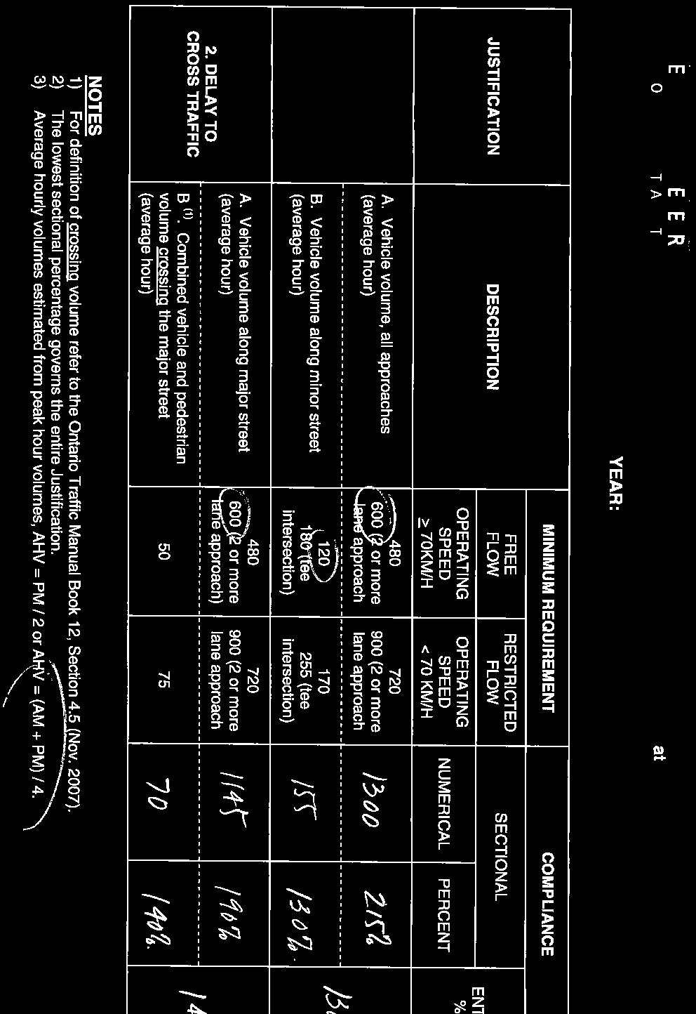
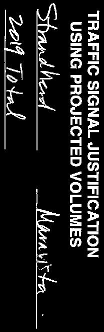


68
St. Stefan Serbian Orthodox Church 1989 and 1993 Prince of Wales Drive, Ottawa REVISED TRANSPORTATION BRIEF
 St. Stefan Serbian Orthodox Church 1989 and 1993 Prince of Wales Drive, Ottawa REVISED TRANSPORTATION BRIEF Prepared By: NOVATECH ENGINEERING CONSULTANTS LTD. Suite 200, 240 Michael Cowpland Drive Ottawa,
9 Leeming Drive Redevelopment Ottawa, ON Transportation Brief. Prepared By: Stantec Consulting Ltd.
 9 Leeming Drive Redevelopment Ottawa, ON Transportation Brief Prepared By: Stantec Consulting Ltd. TIA GUIDELINES CHECKLIST Report Context Municipal Address Comment: Section 1.1 Location relative to major
INDUSTRIAL BUILDING 3009 HAWTHORNE ROAD CITY OF OTTAWA TRANSPORTATION OVERVIEW REVISED. Prepared for: Canada Inc.
 INDUSTRIAL BUILDING 3009 HAWTHORNE ROAD CITY OF OTTAWA TRANSPORTATION OVERVIEW REVISED Prepared for: 7849648 Canada Inc. Octiober 1, 2015 114-598 Overview_2.doc D. J. Halpenny & Associates Ltd. Consulting
4005 Strandherd Drive, City of Ottawa
 Strandherd Drive, City of Ottawa Community Transportation Study Revision # prepared for: Minto Communities -8 Kent St. Ottawa, ON KP B prepared by: - Michael Street Ottawa, ON KJ T December WBS Michael
BLUE SEA VILLAGE MER BLEUE 2159 MER BLEUE ROAD OTTAWA, ONTARIO TRANSPORTATION IMPACT ASSESSMENT. Prepared for: Ontario Limited.
 BLUE SEA VILLAGE MER BLEUE 2159 MER BLEUE ROAD OTTAWA, ONTARIO TRANSPORTATION IMPACT ASSESSMENT Prepared for: 2534189 Ontario Limited April 6, 2018 117-668 TIA Report_2.doc D. J. Halpenny & Associates
MEETING FACILITY 2901 GIBFORD DRIVE CITY OF OTTAWA TRANSPORTATION BRIEF. Prepared for: Holiday Inn Express 2881 Gibford Drive Ottawa, ON K1V 2L9
 MEETING FACILITY 2901 GIBFORD DRIVE CITY OF OTTAWA TRANSPORTATION BRIEF Prepared for: Holiday Inn Express 2881 Gibford Drive Ottawa, ON K1V 2L9 December 18, 2012 112-566 Brief_1.doc D. J. Halpenny & Associates
QUICKIE C STORE AND GAS BAR 1780 HERON ROAD OTTAWA, ONTARIO TRANSPORTATION BRIEF. Prepared for:
 QUICKIE C STORE AND GAS BAR 1780 HERON ROAD OTTAWA, ONTARIO TRANSPORTATION BRIEF Prepared for: Quickie Convenience Stores Larny Holdings Ltd. c/o PBC Group April 15, 2015 115-615 Report_1.doc D. J. Halpenny
OTTAWA TRAIN YARDS PHASE 3 DEVELOPMENT CITY OF OTTAWA TRANSPORTATION IMPACT STUDY. Prepared for:
 OTTAWA TRAIN YARDS PHASE 3 DEVELOPMENT CITY OF OTTAWA TRANSPORTATION IMPACT STUDY Prepared for: The Ottawa Train Yards Inc. 223 Colonnade Road South, Suite 212 Nepean, Ontario K2E 7K3 January 17, 2012
DUNBOW ROAD FUNCTIONAL PLANNING
 DUNBOW ROAD FUNCTIONAL PLANNING Final Report August 3, 216 #31, 316 5th Avenue NE Calgary, AB T2A 6K4 Phone: 43.273.91 Fax: 43.273.344 wattconsultinggroup.com Dunbow Road Functional Planning Final Report
OFFICE/RETAIL DEVELOPMENT 1625 BANK STREET OTTAWA, ONTARIO TRANSPORTATION BRIEF. Prepared for: Canada Inc.
 OFFICE/RETAIL DEVELOPMENT 1625 BANK STREET OTTAWA, ONTARIO TRANSPORTATION BRIEF Prepared for: 9402209 Canada Inc. December 15, 2015 115-625 Report_2.doc D. J. Halpenny & Associates Ltd. Consulting Transportation
Bistro 6. City of Barrie. Traffic Impact Study for Pratt Hansen Group Inc. Type of Document: Final Report. Project Number: JDE 1748
 City of Barrie Traffic Impact Study for Pratt Hansen Group Inc. Type of Document: Final Report Project Number: JDE 1748 Date Submitted: June 12 th, 2017 06/12/17 John Northcote, P.Eng. Professional License
CastleGlenn Consultants Inc.
 February 1 st, 2010 CastleGlenn Consultants Inc. Engineers, Project Managers & Planners Mr. Kevin Yemm Planning and Land Development Richraft Ltd. 2280 St. Laurent Boulevard Suite 201 Ottawa, Ontario (Tel:
NEW YORK CENTRAL PARK SUBDIVISION BLAIS STREET/ST-PIERRE STREET EMBRUN, ONTARIO TRAFFIC IMPACT STUDY. Prepared for:
 NEW YORK CENTRAL PARK SUBDIVISION BLAIS STREET/ST-PIERRE STREET EMBRUN, ONTARIO TRAFFIC IMPACT STUDY Prepared for: Solidex Holdings Limited & Investissement Maurice Lemieux Investments Attn: Mr. Anthony
COMMITTEE RECOMMENDATIONS. That Council approve:
 4. MODIFICATIONS TO INNES ROAD (REGIONAL ROAD 30) AND TENTH LINE ROAD (REGIONAL ROAD 47) TO ACCOMMODATE THE DEVELOPMENT OF THE TRINITY COMMONS SHOPPING CENTRE COMMITTEE RECOMMENDATIONS That Council approve:
MEDICAL/OFFICE BUILDING 1637 BANK STREET OTTAWA, ONTARIO TRANSPORTATION OVERVIEW. Prepared for:
 MEDICAL/OFFICE BUILDING 1637 BANK STREET OTTAWA, ONTARIO TRANSPORTATION OVERVIEW Prepared for: 2434984 Ontario Inc. 13-5510 Canotek Road Ottawa, Ontario K1J 9J5 June 4, 2015 115-613 Report_2.doc D. J.
Barrhaven South Urban Expansion Study Area Community Design Plan
 Barrhaven South Urban Expansion Study Area Community Design Plan FINAL Transportation Master Study Ottawa, Ontario Prepared for: Minto Communities Prepared by: Stantec Consulting Ltd. February 2018 Project
Having held a public hearing, that Council approve:
 3. MODIFICATIONS TO MERIVALE ROAD FROM FALLOWFIELD ROAD TO OLD HIGHWAY 16 TO ACCOMMODATE THE GROWTH WITHIN THE SOUTH MERIVALE BUSINESS PARK - PUBLIC HEARING COMMITTEE RECOMMENDATIONS Having held a public
CPC Parking Lot Riverside Drive. Transportation Rationale
 CPC Parking Lot Transportation Rationale Prepared By: NOVATECH Suite 200, 240 Michael Cowpland Drive Ottawa, Ontario K2M 1P6 September 2015 Novatech File: 114093 Ref: R-2015-153 Table of Contents 1.0 INTRODUCTION...
3.2.2 Proposed Road Network within Phase 1B Lands
 3.2.2 Proposed Road Network within Phase 1B Lands Figure 3.1 also shows the proposed road network within the Premier Gateway Phase 1B Employment Area lands, which features two collector roads providing
FAIRFIELD INN & SUITES HOTEL 135 THAD JOHNSON PRIVATE OTTAWA TRANSPORTATION BRIEF. Prepared for:
 FAIRFIELD INN & SUITES HOTEL 135 THAD JOHNSON PRIVATE OTTAWA TRANSPORTATION BRIEF Prepared for: Bona Building & Management Co. Ltd. Place Vanier, 333 North River Road Vanier, Ontario K1L 8B9 August 12,
Donahue Drive Corridor Traffic Operational Evaluation
 Donahue Drive Corridor Traffic Operational Evaluation PREPARED FOR: THE CITY OF AUBURN PREPARED BY: JANUARY 2007 Donahue Drive Corridor Study--Auburn, Alabama TABLE OF CONTENTS Introduction... 1 Background
HENDERSON DEVELOPMENT 213, 217, 221, 221 ½, 223 HENDERSON AVENUE and 65 TEMPLETON STREET OTTAWA, ONTARIO TRANSPORTATION OVERVIEW.
 HENDERSON DEVELOPMENT 213, 217, 221, 221 ½, 223 HENDERSON AVENUE and 65 TEMPLETON STREET OTTAWA, ONTARIO TRANSPORTATION OVERVIEW Prepared for: 2294170 Ontario Inc. February 2, 2017 117-652 Report_1.doc
HILTON GARDEN INN HOTEL HOTEL EXPANSION 2400 ALERT ROAD, OTTAWA TRANSPORTATION BRIEF. Prepared for:
 HILTON GARDEN INN HOTEL HOTEL EXPANSION 2400 ALERT ROAD, OTTAWA TRANSPORTATION BRIEF Prepared for: Bona Building & Management Co. Ltd. Place Vanier, 333 North River Road Vanier, Ontario K1L 8B9 October
INDUSTRIAL BUILDING 1660 COMSTOCK ROAD CITY OF OTTAWA TRANSPORTATION OVERVIEW. Prepared for:
 INDUSTRIAL BUILDING 1660 COMSTOCK ROAD CITY OF OTTAWA TRANSPORTATION OVERVIEW Prepared for: Simluc Contractors Limited 2550 Blackwell Street, Ottawa K1B 5R1 October 18, 2013 113-584 Overview_1.doc D. J.
APPENDIX H EXISTING TRAFFIC CONDITIONS ANALYSIS
 APPENDIX H EXISTING TRAFFIC CONDITIONS ANALYSIS MEMO : Peter Steacy, P.Eng. Date: December 3, 2014 : Ian Borsuk, P.Eng. Job No.: 3414015-000 Subject: City of Ottawa O-Train Extension Planning & EA Study
Glenn Avenue Corridor Traffic Operational Evaluation
 Glenn Avenue Corridor Traffic Operational Evaluation PREPARED FOR: THE CITY OF AUBURN PREPARED BY: DECEMBER 2007 Glenn Avenue Corridor Study--Auburn, Alabama TABLE OF CONTENTS Introduction... 1 Background
CPC Parking Lot Riverside Drive. Transportation Brief
 CPC Parking Lot 2785 Riverside Drive Transportation Brief Prepared By: NOVATECH Suite 2, 24 Michael Cowpland Drive Ottawa, Ontario K2M P6 7 / 5 / 25 Novatech File: 49 Ref: R-25-22 July 5 th, 25 City of
HOLIDAY INN HOTEL 235 KING EDWARD AVENUE CITY OF OTTAWA TRANSPORTATION BRIEF. Prepared for:
 HOLIDAY INN HOTEL 235 KING EDWARD AVENUE CITY OF OTTAWA TRANSPORTATION BRIEF Prepared for: Momentum Planning & Communications 1165 Greenlawn Crescent Ottawa, ON K1L 6C2 June 29, 2015 115-618 Brief_1.doc
Building a Liveable Ottawa 2031 Backgrounder 5: Barrhaven/Riverside South/Leitrim
 Building a Liveable Ottawa 2031 Backgrounder 5: Barrhaven/Riverside South/Leitrim Wards 3 and 22 Official Plan Transportation Master Plan Cycling Plan Pedestrian Plan October 2013 ottawa.ca/liveableottawa
5858 N COLLEGE, LLC N College Avenue Traffic Impact Study
 5858 N COLLEGE, LLC nue Traffic Impact Study August 22, 2016 Contents Traffic Impact Study Page Preparer Qualifications... 1 Introduction... 2 Existing Roadway Conditions... 5 Existing Traffic Conditions...
Traffic Impact Analysis Walton Acres at Riverwood Athletic Club Clayton, NC
 Traffic Impact Analysis Walton Acres at Riverwood Athletic Club Clayton, NC 1. TABLE OF CONTENTS INTRODUCTION...1 1.1. Site Location and Study Area...1 1.2. Proposed Land Use and Site Access...2 1.3.
APARTMENT BUILDING DEVELOPMENT 1161 HERON ROAD OTTAWA, ONTARIO TRANSPORTATION IMPACT STUDY. Prepared for:
 APARTMENT BUILDING DEVELOPMENT 1161 HERON ROAD OTTAWA, ONTARIO TRANSPORTATION IMPACT STUDY Prepared for: 1649362 Ontario Inc. c/o Manor Park Management 231 Brittany Drive, Suite D Ottawa ON K1K 0R8 July
Traffic Impact Analysis Chatham County Grocery Chatham County, NC
 Chatham County Grocery Chatham County, NC TABLE OF CONTENTS 1. INTRODUCTION... 1 1.1. Location and Study Area... 1 1.2. Proposed Land Use and Access... 2 1.3. Adjacent Land Uses... 2 1.4. Existing ways...
URBAN QUARRY HEADQUARTERS 2717 STEVENAGE DRIVE CITY OF OTTAWA TRANSPORTATION OVERVIEW. Prepared for: Urban Quarry 4123 Belgreen Drive, Ottawa K1G 3N2
 URBAN QUARRY HEADQUARTERS 2717 STEVENAGE DRIVE CITY OF OTTAWA TRANSPORTATION OVERVIEW Prepared for: Urban Quarry 4123 Belgreen Drive, Ottawa K1G 3N2 February 27, 2014 113-584 Overview_1.doc D. J. Halpenny
South Street Campus Lands Development. City of London TRANSPORTATION IMPACT ASSESSMENT
 South Street Campus Lands Development City of London TRANSPORTATION IMPACT ASSESSMENT TW1387 South Street Campus Lands Development City of London TRANSPORTATION IMPACT ASSESSMENT May 2013 South Street
TRAFFIC IMPACT STUDY COMPREHENSIVE UPDATE TOWN OF THOMPSON S STATION, TENNESSEE PREPARED FOR: THE TOWN OF THOMPSON S STATION
 TRAFFIC IMPACT STUDY COMPREHENSIVE UPDATE TOWN OF THOMPSON S STATION, TENNESSEE PREPARED FOR: THE TOWN OF THOMPSON S STATION Transportation Consultants, LLC 1101 17 TH AVENUE SOUTH NASHVILLE, TN 37212
Parking Lot P6C Transportation Impact Assessment
 Transportation Carleton University Parking Lot P6C Transportation Impact Assessment Prepared by: AECOM 302 1150 Morrison Drive 613 820 8282 tel Ottawa, ON, Canada K2H 8S9 613 820 8338 fax www.aecom.com
AMEC Earth and Environmental. Bovaird Drive Environmental Assessment. Traffic Study Final Report. August Excellence in Transportation Planning
 AMEC Earth and Environmental Bovaird Drive Environmental Assessment Traffic Study Final Report August Excellence in Transportation Planning AMEC Earth and Environmental Bovaird Drive Class EA Traffic
VIVA RETIREMENT COMMUNITIES OAKVILLE TRAFFIC IMPACT STUDY
 VIVA RETIREMENT COMMUNITIES OAKVILLE TRAFFIC IMPACT STUDY VIVA RETIREMENT COMMUNITIES OAKVILLE TRAFFIC IMPACT STUDY DECEMBER 2012 READ, VOORHEES & ASSOCIATES TORONTO, ONTARIO Read, Voorhees & Associates
19 July 2016 OUR REF:
 19 July 2016 OUR REF: 602263-01000 194168 Ontario Ltd. 320 McRae Street Ottawa, ON K1Z 5R8 Attention: Brian Casagrande Dear Brian: Re: 320 McRae/1976 Scott Redevelopment CTS Addendum #1 This Addendum has
Prepared For: Shieldbay Developments Inc. c/o Matson, McConnell Ltd. 2430A Bloor Street West Toronto, Ontario M6S 1P9.
 Prepared For: Shieldbay Developments Inc. c/o Matson, McConnell Ltd. 2430A Bloor Street West Toronto, Ontario M6S 1P9 Prepared By: URS Canada Inc. 4 th Floor, 30 Leek Crescent Richmond Hill, Ontario L4B
455 Via Verona Avenue
 TRANSPORTATION Transportation Brief 455 Via Verona Avenue Submitted to Multifaith Housing Initiative by IBI Group March 2015 Table of Contents 1.0 INTRODUCTION... 1 2.0 PROPOSED DEVELOPMENT... 1 2.1 Site
TRAFFIC IMPACT STUDY CRITERIA
 Chapter 6 - TRAFFIC IMPACT STUDY CRITERIA 6.1 GENERAL PROVISIONS 6.1.1. Purpose: The purpose of this document is to outline a standard format for preparing a traffic impact study in the City of Steamboat
485 Ancaster Avenue. Transportation Impact Assessment. Engineering. Planning. Landscape Architecture
 Engineering Land / Site Development Municipal Infrastructure Environmental / Water Resources Traffic / Transportation Structural Recreational 485 Ancaster Avenue Transportation Impact Assessment Planning
Transportation Impact Study for Abington Terrace
 Transportation Impact Study for Abington Terrace Abington Township, Montgomery County, PA Sandy A. Koza, P.E., PTOE PA PE License Number PE059911 Prepared by McMahon Associates, Inc. 425 Commerce Drive,
COMMERCIAL DEVELOPMENT 2015 ROBERTSON ROAD OTTAWA, ONTARIO TRANSPORTATION BRIEF. Prepared for:
 COMMERCIAL DEVELOPMENT 2015 ROBERTSON ROAD OTTAWA, ONTARIO TRANSPORTATION BRIEF Prepared for: First Bay Properties Inc. 311 Richmond Road, Suite 203 Ottawa, ON K1Z 6X3 August 8, 2017 117-663 Brief_1.doc
REDEVELOPMENT TRAFFIC IMPACT STUDY
 REDEVELOPMENT TRAFFIC IMPACT STUDY For Wendy s Parker, Colorado January 215 Prepared for: Sterling Design Associates, LLC 29 W. Littleton Boulevard #3 Littleton, Colorado 812 Prepared by: 1233 Airport
Place Vanier 250 Montreal Road Transportation Impact Study Addendum. Prepared for Broccolini Construction September 20 th, 2012
 Update for the May 31 st, 2012 Traffic Impact Study Prepared for Broccolini Construction 111-23596-00 September 20 th, 2012 2611 Queensview Drive, Suite 300, Ottawa, Ontario CANADA K2B 8K2 Telephone: 613-829-2800
TRAFFIC IMPACT ANALYSIS
 TRAFFIC IMPACT ANALYSIS FOR THE CHAMPAIGN UNIT#4 SCHOOL DISTRICT PROPOSED HIGH SCHOOL (SPALDING PARK SITE) IN THE CITY OF CHAMPAIGN Final Report Champaign Urbana Urbanized Area Transportation Study 6/24/2014
STONEBRIDGE GOLF COMMUNITY - PHASES 10 TO 12
 STONERIDGE GOLF COMMUNITY PHSES 10 TO 12 TRNSPORTTION IMPCT STUDY UGUST 2007 II GROUP TRNSPORTTION IMPCT STUDY TLE OF CONTENTS EXECUTIVE SUMMRY 1. INTRODUCTION...1 2. PROPOSED DEVELOPMENT...1 2.1 Site
ORLEANS GARDENS SHOPPING CENTRE 1615 ORLEANS BOULEVARD CITY OF OTTAWA, ONTARIO TRANSPORTATION IMPACT STUDY. Prepared for:
 ORLEANS GARDENS SHOPPING CENTRE 1615 ORLEANS BOULEVARD CITY OF OTTAWA, ONTARIO TRANSPORTATION IMPACT STUDY Prepared for: Orleans Gardens Shopping Centre Inc. 2851 John Street, Suite 1 Markham, ON K3R 5R7
Walmart (Store # ) 60 th Street North and Marion Road Sioux Falls, South Dakota
 60 th Street North and Marion Road Sioux Falls, South Dakota") Walmart (Store #4865-00) 60 th Street North and Marion Road Sioux Falls, South Dakota Prepared for: Wal-Mart Stores, Inc. Bentonville, Arkansas Prepared by: Kimley-Horn and Associates, Inc. ã2013 Kimley-Horn
Walmart (Store #4865-00) 60 th Street North and Marion Road Sioux Falls, South Dakota Prepared for: Wal-Mart Stores, Inc. Bentonville, Arkansas Prepared by: Kimley-Horn and Associates, Inc. ã2013 Kimley-Horn
Gateway Transportation Study
 Gateway Transportation Study Amherst, Massachusetts SUBMITTED TO University of Massachusetts Amherst Town of Amherst SUBMITTED BY Vanasse Hangen Brustlin, Inc. Watertown, Massachusetts March 213 Back of
Sixth Line Development - Transit Facilities Plan
 Memorandum Date: November 13, 2012 To: From: c.c. Subject: Rob Freeman (Freeman Planning) Kevin Phillips Sixth Line Development - Transit Facilities Plan 33016631 This memo was prepared to review the transit
2. NORTEL CARLING CAMPUS EXPANSION - PROPOSED MODIFICATIONS TO MOODIE DRIVE (REGIONAL ROAD 59) AND HIGHWAY 417 INTERCHANGE
 AND HIGHWAY 417 INTERCHANGE") 2. NORTEL CARLING CAMPUS EXPANSION - PROPOSED MODIFICATIONS TO MOODIE DRIVE (REGIONAL ROAD 59) AND HIGHWAY 417 INTERCHANGE COMMITTEE RECOMMENDATIONS AS AMENDED That Council approve: 1. The endorsement
2. NORTEL CARLING CAMPUS EXPANSION - PROPOSED MODIFICATIONS TO MOODIE DRIVE (REGIONAL ROAD 59) AND HIGHWAY 417 INTERCHANGE COMMITTEE RECOMMENDATIONS AS AMENDED That Council approve: 1. The endorsement
Classification Criteria
 SCHEDULE D TO RECOMMENDED OFFICIAL PLAN AMENDMENT NO. 40 SCHEDULE C-4 Road Criteria Criteria Traffic Service Objective Land Service/Access Typical Daily Traffic Volume Flow characteristics Travel Speed
Traffic Impact Study WestBranch Residential Development Davidson, NC March 2016
 Traffic Impact Study WestBranch Residential Development Davidson, NC March 216 TRAFFIC IMPACT STUDY FOR THE WestBranch Residential Development LOCATED IN DAVIDSON, NC Prepared For: Lennar Carolinas, LLC
TRAFFIC ASSESSMENT River Edge Colorado
 TRAFFIC ASSESSMENT River Edge Colorado Submitted by: Fehr & Peers 621 17th Street, Ste. 231 Denver, CO 8293 (33) 296-43 December, 21 App. M-2 Traffic Assessment River Edge Colorado December 21 TABLE OF
1. Provide a dedicated westbound approach bus lane at the intersection;
 3. MODIFICATIONS AT HIGHWAY 417 WESTBOUND OFF-RAMP/PINCREST ROAD - PUBLIC HEARING COMMITTEE RECOMMENDATIONS Having held a public hearing, that Council approve the preliminary design for the proposed modifications
PRELIMINARY DRAFT WADDLE ROAD / I-99 INTERCHANGE PROJECT ALTERNATIVE ANALYSIS FINAL TRAFFIC SUMMARY REPORT
 PRELIMINARY DRAFT WADDLE ROAD / I-99 INTERCHANGE PROJECT ALTERNATIVE ANALYSIS FINAL TRAFFIC SUMMARY REPORT Prepared by: In Association with: November 2013 EXECUTIVE SUMMARY Patton Township, in partnership
Henderson Avenue Mixed-Use Development
 Zoning Case: Z145-3 Traffic Impact Analysis Henderson Avenue Mixed-Use Development Dallas, TX October 26 th, 216 Kimley-Horn and Associates, Inc. Dallas, Texas Project #644827 Registered Firm F-928 Traffic
PINESTONE TRAFFIC IMPACT STUDY Travelers Rest, South Carolina
 PINESTONE TRAFFIC IMPACT STUDY Travelers Rest, South Carolina Prepared for Longbranch Development Prepared by January 13, 219 ii Table of Contents Subject Page Signature Page... i Table of Contents...
TRAFFIC STUDY GUIDELINES Clarksville Street Department
 TRAFFIC STUDY GUIDELINES Clarksville Street Department 9/1/2009 Introduction Traffic studies are used to help the city determine potential impacts to the operation of the surrounding roadway network. Two
North Oakville. Terms of Reference for Transportation Impact Studies and Transportation Functional Design Studies
 North Oakville Terms of Reference for Transportation Impact Studies and Transportation Functional Design Studies North Oakville Terms of Reference for Transportation Impact Studies and Transportation
Appendix C. NORTH METRO STATION AREA TRAFFIC IMPACT STATEMENT 88th Avenue Station
 Appendix C NORTH METRO STATION AREA TRAFFIC IMPACT STATEMENT 88th Avenue Station Prepared for: Regional Transportation Department and URS Corporation as part of the North Metro EIS David Evans and Associates,
D.13 Transportation and Traffic
 This section addresses transportation and traffic issues and impacts related to the Proposed Project. Section D.13.1 provides a description of the affected environment for the Proposed Project. Applicable
The proposed development is located within 800m of an existing Transit Station where infill developments and intensification are encouraged.
 Stantec Consulting Ltd. 1331 Clyde Avenue, Suite 4 Ottawa ON K2C 3G4 Tel: (613) 722-442 Fax: (613) 722-2799 May 14, 213 File: 1638823 Robinson Park Development Corp. 5699 Power Road Ottawa, ON, K1G 3N4
TRANSPORTATION ANALYSIS REPORT US Route 6 Huron, Erie County, Ohio
 TRANSPORTATION ANALYSIS REPORT US Route 6 Huron, Erie County, Ohio December 12, 2012 Prepared for: The City of Huron 417 Main Huron, OH 44839 Providing Practical Experience Technical Excellence and Client
4. ENVIRONMENTAL IMPACT ANALYSIS 9. TRANSPORTATION AND TRAFFIC
 4. ENVIRONMENTAL IMPACT ANALYSIS 9. TRANSPORTATION AND TRAFFIC 4.9.1 INTRODUCTION The following section addresses the Proposed Project s impact on transportation and traffic based on the Traffic Study
Subject: Solberg Avenue / I-229 Grade Separation: Traffic Analysis
 MEMORANDUM Transportation Bill Troe, AICP Jason Carbee, AICP 12120 Shamrock Plaza Suite 300 Omaha, NE 68154 (402) 334-8181 (402) 334-1984 (Fax) To: Project File Date: Subject: Solberg Avenue / I-229 Grade
METHODOLOGY. Signalized Intersection Average Control Delay (sec/veh)
") Chapter 5 Traffic Analysis 5.1 SUMMARY US /West 6 th Street assumes a unique role in the Lawrence Douglas County transportation system. This principal arterial street currently conveys commuter traffic
Chapter 5 Traffic Analysis 5.1 SUMMARY US /West 6 th Street assumes a unique role in the Lawrence Douglas County transportation system. This principal arterial street currently conveys commuter traffic
Abrams Associates. Transportation Impact Analysis. City of Rocklin. Prepared for: David Mohlenbrok City of Rocklin 4081 Alvis Court Rocklin, CA 95677
 Transportation Impact Analysis Sierra College Boulevard Commercial Project City of Rocklin Prepared for: David Mohlenbrok City of Rocklin 081 Alvis Court Rocklin, CA 95677 Prepared by: 1875 Olympic Boulevard,
CarMax Auto Superstore/ Reconditioning Center #6002 Murrieta, California
 CarMax Auto Superstore/ Reconditioning Center #6002 Murrieta, California TUSTIN 17782 17th Street Suite 200 Tustin, CA 92780-1947 714.665.4500 Fax: 714.665.4501 LOS ANGELES 145 S. Spring Street Suite 120
SECTION 1 - TRAFFIC PLANNING
 SECTION 1 - TRAFFIC PLANNING 1.1 TRAFFIC OPERATIONS 1.1.1 Roadway Functional Classification The Multnomah County Comprehensive Framework Plan s Policy 34: Trafficways and the Functional Classification
Premier Gateway Phase 1B Employment Area Secondary Plan Transportation Study. Paradigm Transportation Solutions Limited
 Premier Gateway Phase 1B Employment Area Secondary Plan Transportation Study Paradigm Transportation Solutions Limited July 217 Project Summary Project Number 177 July 217 Client Town of Halton Hills
Traffic Impact Study, Premier Gold Mines Limited, Hardrock Property
 Traffic Impact Study, Premier Gold Mines Limited, Hardrock Property Prepared for: Premier Gold Mines Limited Prepared by: Stantec Consulting Ltd. November 2014
Draft Report. Traffic Impact Study. Superstore, Wal-Mart, and Kent Development. Yarmouth, Nova Scotia. Prepared for
 oad & Traffic Management Road & Traffic Management R Atlantic Traffic Engineering Specialists Draft Report Traffic Impact Study Superstore, Wal-Mart, and Kent Development Yarmouth, Nova Scotia Prepared
Magnolia Place. Traffic Impact Analysis. Prepared for: City of San Mateo. Prepared by: Hexagon Transportation Consultants, Inc.
 Magnolia Place Traffic Impact Analysis Prepared for: City of San Mateo Prepared by: Hexagon Transportation Consultants, Inc. Updated January 4, 2010 Table of Contents 1. Introduction...1 2. Existing Conditions...6
Harrah s Station Square Casino
 Transportation Analysis Harrah s Station Square Casino Pittsburgh, Pennsylvania Submitted To: City of Pittsburgh and Pennsylvania Gaming Control Board Prepared By: DKS Associates GAI Consultants December
Premier Gateway West Scoped Area Transportation Study Interim Report (Secondary Plan) Paradigm Transportation Solutions Limited
 Paradigm Transportation Solutions Limited") Premier Gateway West Scoped Area Transportation Study Interim Report (Secondary Plan) Paradigm Transportation Solutions Limited April 2018 Project Summary Project Number 170050 April 2018 Client Town
Premier Gateway West Scoped Area Transportation Study Interim Report (Secondary Plan) Paradigm Transportation Solutions Limited April 2018 Project Summary Project Number 170050 April 2018 Client Town
Chapter 4 Traffic Analysis
 Chapter 4 Traffic Analysis PURPOSE The traffic analysis component of the K-68 Corridor Management Plan incorporates information on the existing transportation network, such as traffic volumes and intersection
List of Exhibits...ii
 One Brickell Traffic Study TABLE OF CONTENTS List of Exhibits...ii EXECUTIVE SUMMARY...1 1. INTRODUCTION...2 1.1 Study Area...2 1.2 Study Objective...5 2. EXISTING TRAFFIC CONDITIONS...6 2.1 Data Collection...6
WELCOME TO OPEN HOUSE # 1 June 14, 2017
 Langstaff Road Weston Road to Highway 7 Class Environmental Assessment Study WELCOME TO OPEN HOUSE # 1 June 14, 2017 Please sign in and join our mailing list Purpose of Open House #1 & Study Area York
Fieldgate. Traffic Impact Study Proposed Retail Commercial and Residential Development Thompson Road and Louis St. Laurent Avenue Town of Milton
 Fieldgate Traffic Impact Study Proposed Retail Commercial and Residential Development Thompson Road and Louis St. Laurent Avenue Town of Milton September 214 September 23 214 Ms Debbie Pacchiarotti Our
Bridge Street Corridor Study Report
 Bridge Street Corridor Study Report Prepared for: Prepared by: BRIDGE STREET CORRIDOR STUDY REPORT PREPARED FOR: CITY OF ARROYO GRANDE COMMUNITY DEVELOPMENT DEPARTMENT 300 EAST BRANCH STREET ARROYO GRANDE,
THIS PAGE LEFT BLANK INTENTIONALLY
 GA SR 25 Spur at Canal Road Transportation Impact Analysis PREPARED FOR GLYNN COUNTY, GEORGIA 1725 Reynolds Street, Suite 300 Brunswick, Georgia 31520 PREPARED BY 217 Arrowhead Boulevard Suite 26 Jonesboro,
TRANSPORTATION IMPACT STUDY
 Dundas MEP Developments Inc. City of Toronto 219 and 231 Dundas Street East, Proposed Mixed-Use Development TRANSPORTATION IMPACT STUDY 9782/2 April 216 LEA Consulting Ltd. Consulting Engineers & Planners
Transportation Impact Study Guidelines AS ADOPTED BY REGION OF WATERLOO COUNCIL SEPTEMBER 18, 2013 REPORT NO. P
 Transportation Impact Study Guidelines AS ADOPTED BY REGION OF WATERLOO COUNCIL SEPTEMBER 18, 2013 REPORT NO. P-13-088 HOUSEKEEPING EDITS APPLIED UPDATED TO FILE VERSION 4, JULY 22, 2014 TABLE OF CONTENTS
Design Criteria. Design Criteria
 F Design Criteria Design Criteria Ministry of Transportation Ministère des Transports DESIGN CRITERIA Page: 1 of 13 WORK PROJECT NO. N/A GO Bloomington Station TYPE OF PROJECT LOCATION Bloomington Road
Technical Memorandum TRAFFIC IMPACT STUDY. RIDLEY ROAD CONVENIENCE STORE Southampton County, VA. Prepared for: Mr. David Williams.
 Technical Memorandum TRFFIC IMPCT STUDY RIDLEY ROD CONVENIENCE STORE Southampton County, V Prepared for: Mr. David Williams By: Charles Smith, P.E., PTOE EPR Charlottesville, V July 2014 1 TBLE OF CONTENTS
Figure 1: East West Connector Alignment Alternatives Concept Drawing
 Page 2 of 9 Figure 1: East West Connector Alignment Alternatives Concept Drawing The Montebello Drive extension will run north south and connect Wilsonville Road to the Boones Ferry Road to Brown Road
FRONT RANGE CROSSINGS TRAFFIC IMPACT STUDY
 FRONT RANGE CROSSINGS TRAFFIC IMPACT STUDY Prepared for: City of Thornton And Colorado Department of Transportation Prepared by: 11 Blake Street, Suite 2 Denver, Colorado 822 Contact: Brian Bern, PE, PTOE
Traffic Impact Study Little Egypt Road Development Denver, North Carolina June 2017
 Traffic Impact Study Little Egypt Road Development Denver, North arolina June 2017 N. Little Egypt Road DQ\ QDQFLQJ VDOHV RU RWKHU SHUIRUPDQFH EDVHG FULWHULD Proposed Site Driveways Site Driveway 1 TRAFFI
Welcome. The Brooklin Secondary Plan and Transportation Master Plan are collectively referred to as the Brooklin Study.
 Welcome The Town of Whitby is undertaking a study to prepare a Secondary Plan and Transportation Master Plan to guide and manage growth in the Brooklin area. The Brooklin Secondary Plan and Transportation
Date: September 7, Project #: Re: Spaulding Youth Center Northfield, NH Property. Traffic Impact Study
 To: Ms. Susan C. Ryan Spaulding Youth Center 72 Spaulding Road Northfield, NH 03276 Date: September 7, 2017 Project #: 52455.00 From: Robin Bousa Director of Transportation Systems Re: Spaulding Youth
APPENDIX G: INTERSECTION NEEDS AT OKEECHOBEE BOULEVARD
 APPENDIX G: INTERSECTION NEEDS AT OKEECHOBEE BOULEVARD INTERSECTION NEEDS AT SR 7 and OKEECHOBEE BOULEVARD SR 7 Extension Project Development and Environment (PD&E) Study From Okeechobee Boulevard (SR
Meadowlake Ranch Traffic Impact Analysis (LSC #184600) August 27, 2018
 August 27, 2018") LSC TRANSPORTATION CONSULTANTS, INC. 545 East Pikes Peak Avenue, Suite 210 Colorado Springs, CO 80903 (719) 633-2868 FAX (719) 633-5430 E-mail: lsc@lsctrans.com Website: http://www.lsctrans.com Traffic
LSC TRANSPORTATION CONSULTANTS, INC. 545 East Pikes Peak Avenue, Suite 210 Colorado Springs, CO 80903 (719) 633-2868 FAX (719) 633-5430 E-mail: lsc@lsctrans.com Website: http://www.lsctrans.com Traffic
Highway 111 Corridor Study
 Highway 111 Corridor Study June, 2009 LINCOLN CO. HWY 111 CORRIDOR STUDY Draft Study Tea, South Dakota Prepared for City of Tea Sioux Falls Metropolitan Planning Organization Prepared by HDR Engineering,
TRANSPORTATION IMPACT STUDY PROPOSED RIVERFRONT 47 MIXED USE DEVELOPMENT
 November 2016 TRANSPORTATION IMPACT STUDY PROPOSED RIVERFRONT 47 MIXED USE DEVELOPMENT & Aspinwall Borough, Sharpsburg Borough & O Hara Township, Allegheny County, Pennsylvania Prepared for: Riverfront
192 & 196 Bronson Avenue / 31 Cambridge Street
 Bronson Inc. July 213 192 & 196 Bronson Avenue / 31 Cambridge Street TRANSPORTATION BRIEF Prepared by: Study 192 Bronson Type Avenue July 213 Study Transportation Name Brief February 211 TB Check List