Bank Street Retail/Hotel Development
|
|
|
- Marlene Davidson
- 6 years ago
- Views:
Transcription


1 M a y Bank Street Retail/Hotel Development Transportation Brief Google 214 Bing 214 Prepared for: Prepared by:
2 Study 89-9 Type Bank Street May 214 Study Retail/Hotel Name Development February 211 TB Check List TIS / TB/ CTS Check List prepared for: N45 Architects Inc. 2nd Floor, 43 Eccles Street Ottawa, ON K1R 6S3 OUR REF:TO3157TOL OUR Report Context Municipal address; Location relative to major elements of the existing transportation system (e.g., the site is located in the southwest quadrant of the intersection of Main Street/ First Street, 6metres from the Maple Street Rapid Transit Station); Existing land uses or permitted use provisions in the Official Plan, Zoning By-law, etc.; Proposed land uses and relevant planning regulations to be used in the analysis; Proposed development size (building size, number of residential units, etc.) and location on site; Estimated date of occupancy; Planned phasing of development; Proposed number of parking spaces (not relevant for Draft Plans of Subdivision); Proposed access points and type of access (full turns, right-in/ right-out, turning restrictions, etc. Study area;
3 Study 89-9 Type Bank Street May 214 Study Retail/Hotel Name Development February 211 Existing Conditions Existing roads and ramps in the study area, including jurisdiction, classification, number of lanes, and posted speed limit; Existing intersections, indicating type of control, lane configurations, turning restrictions, and any other relevant data (e.g., extraordinary lane widths, grades, etc.); Existing access points to adjacent developments (both sides of all roads bordering the site); Existing transit system, including stations and stops; Existing on- and off-road bicycle facilities and pedestrian sidewalks and pathway networks; Existing system operations (V/C, LOS); Major trip generators/ attractors within the Study Area should be indicated. Demand Forecasting General background growth; Not required for TB Other study area developments; Changes to the study area road network; Future background system operations (V/C, LOS, queue lengths): Not required for TB Trip generation rates; Trip distribution and assignment.
4 Study 89-9 Type Bank Street May 214 Study Retail/Hotel Name Development February 211 Impact Analysis Total future system operations (V/C, LOS, queue lengths); Signal and auxiliary lane (device) warrants; Operational/ safety assessment (e.g., sight line assessment where grades are an issue); Storage analysis for closely spaced intersections; Pedestrian and bicycle network connections and continuity; On-site circulation and design; Potential for neighbourhood impacts; and TDM. Not required for TB Synchro Files CTS Impact Analysis Network Capacity Analysis; Non-auto network connections and continuity; Potential for community impacts, and TDM. Synchro Files Screenline Analysis
5 89 9 Bank Street Retail/Hotel Development Transportation Brief prepared for: N45 Architects Inc. 2 nd Floor, 43 Eccles Street Ottawa, ON K1R 6S3 prepared by: 1223 Michael Street Suite 1 Ottawa, ON K1J 7T2 May 13, 214 TO3157TOL
6 89 9 Bank Street Transportation Brief May 214 Table of Contents 1. Introduction Existing Conditions Area Road Network Existing Study Area Intersections Existing Intersection Operations Demand Forecasting Background Traffic Growth from Lansdowne Park Redevelopment Site Vehicle Trip Generation Vehicle Traffic Distribution and Assignment Future Traffic Operations Site Plan Review Findings and Recommendations List of Figures Figure 1: Local Context... 1 Figure 2: Proposed Site Plan... 2 Figure 3: Existing Afternoon Peak Hour Traffic Volumes... 6 Figure 4: Lansdowne Park Redevelopment Afternoon Peak Hour Site-Generated... 8 Figure 5: Projected Afternoon Peak Hour Site-Generated Traffic Volumes Figure 6: Redistributed Existing Afternoon Peak Hour Site Traffic Volumes Figure 7: Total Projected Traffic Volumes List of Tables Table 1: Existing Performance at Study Area Intersections... 7 Table 2: ITE Trip Generation Rates... 9 Table 3: Modified Person Trip Generation... 9 Table 4: Grocery Modal Site Trip Generation... 1 Table 5: Specialty Retail Modal Site Trip Generation... 1 Table 6: Hotel Modal Site Trip Generation Table 7: Total Site Vehicle Trip Generation Table 8: Projected Performance at Study Area Intersections Appendices Appendix A Current Peak Hour Traffic Volumes Appendix B SYNCHRO Capacity Analysis: Existing Conditions Appendix C Lansdowne Park Redevelopment Traffic Appendix D SYNCHRO Capacity Analysis: Projected Conditions

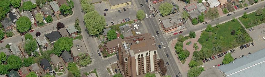
7 89 9 Bank Street Transportation Brief May INTRODUCTION From the information provided, a redevelopment comprised of approximately 39, ft² of retail and a 116 room hotel is being proposed for a site on the west side of Bank Street, south of Thornton Avenue. The site, which is municipally known as 89 9 Bank Street, is currently occupied by a Beer Store, a pay-and-display parking lot and a quick lube shop. These land uses will be replaced by the proposed development, with a new Beer Store incorporated into the project. The site s local context is depicted in Figure 1 and the proposed Site Plan is depicted in Figure 2. Access to the site is currently via two driveway connections to Bank Street and a single driveway connection to Monk Street. The proposed development will provide two driveway connections to Monk Street (one for garbage collection/loading and one providing access to the lower level parking garage) and one to Thornton Street (hotel loading only). There will be no vehicle connections directly to Bank Street. Figure 1: Local Context As part of the Site Plan Approval process, the City of Ottawa requires submission of a Transportation Impact Assessment (TIA) consistent with their guidelines dated October 26. With respect to these guidelines and for this level of development, a Transportation Brief (TB) is considered the appropriate type of study. Given the proposed development consists of retail/hotel land uses that will generate the highest traffic volumes during the weekday afternoon peak hour and given study area intersections currently operate with similar Levels of Service during both peak hours, only the afternoon peak hour will be assessed, in detail, herein. Page 1

8 Figure 2: Proposed Site Plan
9 89 9 Bank Street Transportation Brief May EXISTING CONDITIONS 2.1 Area Road Network Bank Street is an undivided arterial roadway with an unposted speed limit understood to be 5 km/h. Within the study area, the cross-section of Bank Street consists of two travel lanes in each direction with on-street parking located along both sides of the road. Onstreet parking/stopping is not permitted along the east side of the road during the morning peak hour and is not permitted along the west side of the road during the afternoon peak hour. Fifth Avenue is a collector roadway with a posted speed limit of 4 km/h. Its crosssection consists of a single travel lane in both directions with on-street parking located along the north side of the road. Monk Street is a local roadway with a posted speed limit of 4 km/h. Its cross-section consists of a travel lane in both directions with on-street parking located along the east side of the road. Holmwood Avenue is a local roadway with a posted speed limit of 4 km/h. Its crosssection west of Bank Street consists of a travel lane in both directions with on-street parking located along the north side of the road. East of Bank Street, Holmwood Avenue operates as a one-way roadway in the eastbound direction with on-street parking located along the north side of the road. Thornton Avenue is a local roadway with an unposted speed limit understood to be 5 km/h. Its cross-section west of Bank Street consists of a travel lane in both directions with on-street parking located along the south side of the road. East of Bank Street, Thornton Avenue continues as Regent Street, which operates as a one-way roadway in the eastbound direction, with on-street parking provided along the north side of the road. It is noteworthy that peak hour field observations revealed that on-street parking within the study area is well utilized, however, relatively obtainable. This may change with the opening of the redeveloped Lansdowne Park, and will change when there are special/sporting events occurring. Page 3

10 89 9 Bank Street Transportation Brief May Existing Study Area Intersections Bank/Fifth The Bank/Fifth intersection is a signalized four-legged intersection. The north and southbound approaches consist of a shared through/left-turn lane and a shared through/right-turn lane. The westbound approach consists of a left-turn lane and a shared/through right-turn lane. The eastbound approach consists of a single full movement lane. All movements are permitted at this location. Bank/Thornton & Regent The Bank/Thornton & Regent intersection is an unsignalized off-set four-legged intersection with STOP control on the eastbound approach only. The north and southbound approaches consist of a shared through/left-turn lane and a shared through/right-turn lane. The west leg (Thornton Avenue) consists of a single fullmovement lane. The east leg (Regent Street) operates as a one-way roadway in the eastbound direction. All movements are permitted at this location. Bank/Holmwood The Bank/Holmwood intersection is a signalized four-legged intersection. The north and southbound approaches consist of a shared through/left-turn lane and a shared through/right-turn lane. The west leg consists of a single full-movement lane and the east leg operates as a one-way roadway in the eastbound direction only. All movements are permitted at this location. Page 4

11 89 9 Bank Street Transportation Brief May 214 Fifth/Monk The Fifth/Monk intersection is an unsignalized T intersection with STOP control on the minor approach only. A single lane approach is provided for each leg of this intersection and all movements permitted. Holmwood/Monk The Holmwood/Monk intersection is an unsignalized four-legged intersection with all-way STOP control. A single lane approach is provided for each leg of this intersection and all movements permitted. 2.3 Existing Intersection Operations As mentioned previously, the critical time period in terms of vehicles volumes for the proposed land uses and study area intersections is considered to be the weekday afternoon peak hour. Therefore, illustrated as Figure 3, are the most recent weekday afternoon peak hour traffic volumes at study area intersections. These traffic volumes were obtained from the City of Ottawa for the signalized Bank/Fifth and Bank/Holmwood intersections and the traffic volumes at the unsignalized study area intersection were collected by Delcan (April 214) during the afternoon peak hour only. Detailed peak hour traffic volumes are included as Appendix A. Page 5
12 STOP STOP STOP STOP STOP 89 9 Bank Street Transportation Brief May 214 Figure 3: Existing Afternoon Peak Hour Traffic Volumes Fifth Bank Thornton Regent Monk SITE Holmwood It should be noted that the weekday traffic counts obtained from the City of Ottawa for the Bank/Fifth and Bank/Holmwood intersections indicate slightly lower volumes (approximately 1 to 15 veh/h fewer) during the years 213/214 when compared to the traffic volumes collected during the summer 28. This recent decrease in traffic volumes can be attributed to the closure of a northbound lane along Bank Street with respect to the Lansdowne Park renewal construction, south of the study area. It should also be noted, the data collected at the Bank/Fifth intersection was collected on the Friday before the July long weekend. Typically, traffic data collected on Fridays/Mondays leading up to or following statutory holidays will result in lower volumes. Regardless of the inconsistent data, the difference in volumes will have a negligible effect on the subsequent existing/projected intersection performance analysis. Therefore, no further data collection is required. The following Table 1 provides a summary of existing traffic operations at the study area intersections, based on the Synchro (V8) traffic analysis software. The study area intersections were assessed in terms of the volume-to-capacity (v/c) ratio and the corresponding Level of Service (LoS) for the critical movement(s). The study area Page 6
13 89 9 Bank Street Transportation Brief May 214 intersections as a whole were assessed based on a weighted v/c ratio. The Synchro model output of existing conditions is provided within Appendix B. Table 1: Existing Performance at Study Area Intersections Weekday PM Peak Intersection Critical Movement Intersection as a whole max. v/c LoS or avg. Movement Delay (s) LoS v/c delay (s) Bank/Fifth 1 A.59 NBT 15.9 A.44 Bank/Thornton 1 B 12.5 EBL Bank/Holmwood 1 A.46 SBT 8.9 A.39 Monk/Fifth A 9.3 NBL Monk/Holmwood A 7.5 WBT Note: Analysis of signalized intersections assumes a PHF of.95 and a saturation flow rate of 18 veh/h/lane. 1 Analyzed as area type CBD and with one northbound through lane north of Holmwood Avenue due to on-street parking. As shown in Table 1, the signalized study area intersections, as a whole, are currently operating at an excellent LoS A or better during the weekday afternoon peak hour. With regard to critical movements at study area intersections, all critical movements are operating at an excellent LoS B or better during the weekday afternoon peak hour. This satisfies the City of Ottawa s current operating standard of LoS D or better (.9 > v/c >.). Field observations at study area intersections confirm the above findings. However, minor delays to north and southbound vehicles travelling along Bank Street were observed. These delays were caused by signalized intersections, left-turning vehicles, vehicles negotiating on-street parking, pedestrians, cyclists, etc. As Bank Street is considered a Traditional Mainstreet, these minor delays are considered acceptable. It has also been observed that on weekdays where on-street parking is permitted (it is not permitted during peak hours, in the direction of peak directional flow), traffic can be slower moving on Bank Street through the Glebe due to the reduced road capacity, increased use of the adjacent parking spaces and more pedestrians. As previously mentioned, when the redeveloped Lansdowne Park is operational, intersection operations along Bank Street will be impacted and increased delays are expected both during peak hours, and at all other times as well. It should also be noted, approximately 5 veh/h were observed cutting through the site between Bank Street and Monk Street during the weekday afternoon peak hour. As the proposed development will only have access to Monk Street and Thornton Avenue, the opportunity for cut-through through the site between Monk Street and Bank Street will be eliminated. Page 7
14 STOP STOP STOP STOP 89 9 Bank Street Transportation Brief May DEMAND FORECASTING 3.1 Background Traffic Growth from Lansdowne Park Redevelopment The proposed site is located approximately 5 m north of Lansdowne Park, which is currently under construction and scheduled to be operational in summer 214. The following Figure 4 illustrates the projected increase in afternoon peak hour traffic volumes at the study area intersections generated by the redevelopment of Lansdowne Park. These volumes, which will be included in the ensuing analysis, were obtained from the Lansdowne Park TIA prepared by McCormick Rankin. Excerpts from the Lansdowne Park TIA are included as Appendix C. It is noteworthy that these afternoon peak hour volumes are related to Lansdowne Park s retail, office and residential uses. The significant traffic impact of special/sporting events are not addressed herein. Figure 4: Lansdowne Park Redevelopment Afternoon Peak Hour Site-Generated Traffic Volumes Fifth Bank Thornton Regent Monk SITE Holmwood Site Vehicle Trip Generation The following Table 2 summarizes the appropriate vehicle trip generation rates obtained from the 9 th Edition of the Institute of Transportation Engineers (ITE) Trip Generation Page 8
15 89 9 Bank Street Transportation Brief May 214 Manual for the proposed retail and hotel development. With respect to the existing Beer Store land use (to be maintained), its projected vehicle trip generation is assumed to be 1% of the observed traffic volumes at the site driveway connections (depicted in Figure 3). Table 2: ITE Trip Generation Rates Data Land Use Source AM Peak Supermarket ITE 85 T = 3.4(X); Specialty Retail Centre ITE 826 T = 1.36(X); T = 1.2(X) Trip Rates PM Peak T = 9.48(X); Ln(T) =.74 Ln(X) T = 2.71(X); T = 2.4(X) Hotel ITE 31 T =.53(du); T =.6(du); Notes: T = Average Vehicle Trip Ends X = 1, ft 2 Gross Floor Area du = Dwelling units Specialty Retail AM Peak is assumed to be 5% of the PM Peak As ITE trip generation surveys only record vehicle trips and typically reflect highly suburban locations (with little to no access by travel modes other than private automobiles), adjustment factors appropriate to the more urban study area context were applied to attain estimates of person trips for the proposed development. This approach is considered appropriate within the industry for urban infill developments. To convert ITE vehicle trip rates to person trips, an auto occupancy factor and a non-auto trip factor were applied to the ITE vehicle trip rates. Our review of available literature suggests that a combined factor of approximately 1.3 is considered reasonable to account for typical North American auto occupancy values of approximately 1.15 and combined transit and non-motorized modal shares of less than 1%. As such, the person trip generation for the proposed site is summarized in Table 3. Table 3: Modified Person Trip Generation Land Use Data Source Area AM Peak (persons) PM Peak (persons) In Out Total In Out Total Grocery ITE 85 29,4 ft Specialty Retail Centre ITE 826 9,9 ft Hotel ITE units Total Person Trips Note: 1.3 factor to account for typical North American auto occupancy values of approximately 1.15 and combined transit and non-motorized modal shares of less than 1% Page 9
16 89 9 Bank Street Transportation Brief May 214 The person trips shown in Table 3 for the proposed site were then reduced by modal share values based on the site s location and proximity to adjacent communities, employment, other shopping uses and transit availability. Modal share and pass-by 1 values for the proposed supermarket, specialty retail and hotel are summarized in Table 4, 5, and 6, respectively, with the total site vehicle trip generation summarized in Table 7. In addition to the pass-by reduction, a multi-purpose 2 trip reduction of 1% has been removed to account for internal trips between the proposed land uses. This reduction is also summarized in Table 7. Table 4: Grocery Modal Site Trip Generation AM Peak Travel Mode Mode Share (Persons/hr) PM Peak (Persons/hr) In Out Total In Out Total Auto Driver 4% Auto Passenger 15% Transit 15% Non-motorized 3% Total Person Trips 1% Less 3% Pass-by Total 'New' Auto Trips Table 5: Specialty Retail Modal Site Trip Generation AM Peak Travel Mode Mode Share (Persons/hr) PM Peak (Persons/hr) In Out Total In Out Total Auto Driver 4% Auto Passenger 15% Transit 15% Non-motorized 3% Total Person Trips 1% Less 5% Pass-by Total 'New' Auto Trips Pass-by values are trips attracted to the proposed site from existing traffic passing-by on adjacent study area roadways. These trips are not diverted from roadways outside the study area. 2 A multi-purpose trip is a single person trip to/from the proposed site accounting for multiple trips to/from various proposed on-site land uses (i.e. a person will not leave and return to the site if they wish to make trip to the specialty retail and the supermarket on the same site). Page 1
17 89 9 Bank Street Transportation Brief May 214 Table 6: Hotel Modal Site Trip Generation Travel Mode Mode Share AM Peak (Persons/hr) PM Peak (Persons/hr) In Out Total In Out Total Auto Driver 5% Auto Passenger 25% Transit 5% Non-motorized 2% Total Person Trips 1% Total 'New' Auto Trips As depicted in Figure 3, existing site-generated traffic to/from the Beer Store parking lot was observed to be 1 veh/h two-way total during the weekday afternoon peak hour. These existing volumes, as summarized in Table 7, are assumed to be 1% attributed to the Beer Store, which is to be reconstructed and incorporated into the proposed development. Table 7: Total Site Vehicle Trip Generation Land Use AM Peak (veh/h) PM Peak (veh/h) In Out Total In Out Total Existing Beer Store Supermarket Specialty Retail Hotel Less Retail/Supermarket Pass-by Less Multi-Purpose Trips (1%) Total Site-Generated Auto Trips Less Existing Site-Generated Tips Total 'New' Auto Trips As shown in Table 7, the total number of potential new two-way vehicle trips for the proposed development is approximately 145 veh/h during the critical weekday afternoon peak hour comprised of approximately 6 veh/h inbound and 85 veh/h outbound. The site as a whole (including the existing Beer Store traffic) is projected to generate approximately 245 veh/h during the critical weekday afternoon peak hour. Page 11
18 STOP STOP STOP STOP STOP STOP STOP STOP 89 9 Bank Street Transportation Brief May Vehicle Traffic Distribution and Assignment The projected distribution of site-generated traffic was based on the existing road network and our knowledge of the surrounding area. The resultant distribution is outlined as follows: 35% to/from the north via Bank Street; 35% to/from the south via Bank Street; 2% to/from west via Fifth Avenue and Holmwood Avenue; and 1% to/from east via Fifth Avenue. Based on these distributions, new and pass-by site-generated trips were assigned to the study area network and are illustrated as Figure 5. It should be noted, all projected peak hour site-generated traffic is assumed to be to/from the proposed driveway connection to Monk Street that provides access to the lower level parking garage. The two driveway connections providing access to the site s loading areas (one to Monk Street and one to Thornton Street) will experience negligible/no traffic volumes during peak hours. Figure 5: Projected Afternoon Peak Hour Site-Generated Traffic Volumes New Pass-by Fifth Fifth Bank 18 Thornton 15 Regent 5 Monk SITE 25 Bank 14 Thornton Regent 46 8 Monk SITE Holmwood Holmwood With respect to the projected site-generated traffic related to the Beer Store land use, its existing site-generated traffic to/from the Bank Street driveway connection is assumed to be redistributed/reassigned to/from the Monk Street driveway connection, given the Page 12
19 STOP STOP STOP STOP STOP 89 9 Bank Street Transportation Brief May 214 existing Bank Street driveway connection will be removed. This assumes the worst-case in terms of projected traffic volumes on Monk Street, as it assumes all Beer Store patrons will continue to park on-site only. As such, it is also important to note that a number of future Beer Store and retail patrons may elect to park on-street within the study area. The following Figure 6 depicts the existing Beer Store site-generated traffic to/from Bank Street, redistributed/reassigned to/from the Monk Street driveway connection. The observed trips to/from the Bank Street driveway connection were reassigned to the study area network based on the previously mentioned assumed projected vehicle distribution. Figure 6: Redistributed Existing Afternoon Peak Hour Site Traffic Volumes Fifth Thornton Bank Regent Monk SITE Holmwood FUTURE TRAFFIC OPERATIONS For the purpose of this assessment, total projected traffic volumes were derived by superimposing projected Lansdowne Park generated traffic volumes (Figure 4), projected site-generated traffic volumes (Figure 5) and the redistributed exiting site-generated traffic volumes (Figure 6) onto existing traffic volumes (Figure 3) (i.e. Figure 4 + Figure 5 + Figure 6 + Figure 3 = Total projected traffic volumes). The resulting total projected traffic volumes used in the subsequent analysis are illustrated as Figure 7. Page 13
20 STOP STOP STOP STOP 89 9 Bank Street Transportation Brief May 214 Figure 7: Total Projected Traffic Volumes Fifth Bank 49 Thornton Regent Monk SITE Holmwood The following Table 8 provides a summary of projected peak hour performances of study area intersections. The Synchro model output of projected conditions is provided within Appendix D. Table 8: Projected Performance at Study Area Intersections Weekday PM Peak Intersection Critical Movement Intersection as a whole max. v/c LoS or avg. Movement Delay (s) LoS v/c delay (s) Bank/Fifth 1 B.69 NBT 13.8 A.53 Bank/Thornton 1 B 11.8 EBL Bank/Holmwood 1 A.52 SBT 1.2 A.48 Monk/Fifth A 1. NBL Monk/Site B 1.5 WBL Monk/Holmwood A 8.1 SBT Note: Analysis of signalized intersections assumes a PHF of.95 and a saturation flow rate of 18 veh/h/lane. 1 Analyzed as area type CBD and with one northbound through lane north of Holmwood Avenue, as onstreet parking is permitted along the east side of the Bank Street during the afternoon peak hour. Page 14
21 89 9 Bank Street Transportation Brief May 214 As shown in Table 8, study area intersections as a whole and their respective critical movements are projected to operate at an acceptable LoS B or better during the afternoon peak hour. This is similar to, if not the same as, the existing conditions summarized in Table 1. With respect to the proposed site driveway connection to Monk Street, it is projected to operate with acceptable delays of 1 seconds during the afternoon peak hour with 95 th percentile queues of approximately 6 meters (no more than 1 vehicle in queue) on-site. As for vehicles entering the site, queues/delays are projected to be negligible. With regard to traffic volumes on the local and collector roadways within the study area, they are projected to be in the order of 2 to 25 veh/h on local streets (i.e. Monk Street and Holmwood Street) and 3 to 35 veh/h on collectors streets (i.e. Fifth Street) during the weekday afternoon peak hour. Based on the foregoing afternoon peak hour analysis, it is reasonable to assume that study area intersections will operate similar to exiting conditions during the morning peak hour with the additional projected site-generated traffic, particularly as the Beer Store and specialty retail land uses will not be open. 5. SITE PLAN REVIEW This section provides an overview of site access, parking requirements, pedestrian circulation and transit accessibility. The proposed Site Plan was previously illustrated as Figure 2. Parking A total of 126 parking spaces are proposed to serve the subject site. According to the City s minimum By-Law requirements for Area B, identified in Schedule 1 of the City s Zoning By-Law, 156 parking spaces should be provided to serve this site. As such, the proponent will likely be required to seek a By-Law variance for the proposed amount of parking. As mentioned previously, on-street parking is provided along all study area roadways and is well utilized, however, relatively obtainable. This may, or may not, change with the opening of the redeveloped Lansdowne Park. Regarding parking space dimensioning, they are noted as 5.2 m in length and 2.6 m in width, which meets the City s minimum By-Law requirements. Site Circulation With regard to on-site circulation, the proposed drive aisle and ramp widths are noted as being 6.7 to 8.5 m, which is considered acceptable. The lower level parking garage ramp grades are identified as 14%, which is considered acceptable if appropriate transition grades are provided. If ramp grades exceed 12% and are exposed to weather, a subsurface melting device should be installed, sufficient to keep the ramp free from ice/snow at all times. Page 15
22 89 9 Bank Street Transportation Brief May 214 Access Requirements Based on projected volumes and proximity to adjacent intersections, additional traffic control/auxiliary turn lanes are not warranted or required at the proposed driveway connections. With respect to heavy vehicles, sufficient turning radii should be provided to accommodate delivery/fire/garbage collection vehicles. Pedestrians/Transit Sidewalks are currently provided along both sides of all study area roadways connecting pedestrians to transit service and other adjacent development. A multi-use pathway is provided along the Rideau Canal, located approximate 6 m east of the proposed site. Bus stops are currently provided along Bank Street at the Bank/Fifth and Bank/Holmwood intersections. OC Transpo service on Bank Street is currently provided by regular (Black) Routes #1 and 7. Bicycles A total of 17 retail and 6 hotel bicycle parking spaces should be provided to satisfy the City s minimum Zoning By-Law requirements. A bicycle rack is identified on the Site Plan, located at the south end of the site fronting Bank Street, next to the proposed retail land uses. The location of bicycle parking is in accordance with the City s By-Law requirements. According to the City s Cycling Plan, Bank Street, Fifth Avenue, Holmwood Avenue, Monk Street and Thornton Avenue are all classified as local routes. Within the study area, bicycle lanes exist along Monk Street south of Holmwood Avenue. 6. FINDINGS AND RECOMMENDATIONS Based on the foregoing analysis of the proposed site, the following transportation-related findings and recommendations are offered: Given the proposed development consists of retail/hotel land uses that will generate the highest traffic volumes during the weekday afternoon peak hour and given study area intersections currently operate with similar Levels of Service during both the weekday morning and afternoon peak hours, only the critical weekday afternoon peak hour was assessed; Study area intersections are currently operating at good Levels of Service during the afternoon peak hour. However, minor delays to north and southbound vehicles travelling along Bank Street were observed. These delays were caused by the combination of closely spaced signalized intersections, left-turning vehicles, vehicles negotiating on-street parking, pedestrians, cyclists, etc. As Bank Street is considered a Traditional Mainstreet, these minor delays are considered acceptable; Page 16
23 89 9 Bank Street Transportation Brief May 214 The proposed development is projected to generate an increase in two-way traffic volumes of approximately 145 veh/h during the weekday afternoon peak hour. This volume excludes traffic from the Beer Store, which is already accounted for in the existing traffic volumes; At full site build-out, study area intersections as a whole are projected to operate at acceptable levels of service during the weekday afternoon peak hour. However, when the redeveloped Lansdowne Park is operational, intersection operations along Bank Street will be impacted and increased delays are expected; The total projected traffic travelling along the local and collector roadways is in the order of 25 and 35 veh/h, respectively; A number of future Beer Store/retail patrons may elect to park on-street within the study area, as opposed to on-site within the proposed lower level parking garage; The proposed amount of vehicle parking does not meet the City s By-Law requirements. As such, the proponent will likely be required to seek a By-Law variance for the proposed parking supply; The proposed lower level parking garage ramp widths and grades are considered acceptable, provided appropriate transition grades are implemented; With respect to the redevelopment of Lansdowne Park and how it s day-to-day traffic will impact study area intersections, the projected analysis indicates that study area intersections will continue to operate at acceptable Levels of Service during the critical weekday afternoon peak hour. However, as observed, traffic operations can be negatively influenced by additional mid-block delays due to vehicles negotiating on-street parking, pedestrians, cyclists, etc. As Bank Street is considered a Traditional Mainstreet, it is important to note that these delays are considered acceptable, if Bank Street is to be a successful Mainstreet; and This analysis does not address special event or game time traffic associated with the redeveloped Lansdowne Park. For these event, when the demand for on-site (Lansdowne) and off-site (neighbourhood) parking will be significant, traffic in the study area will be significant and delays along the Bank Street corridor are to be expected. Page 17


24 89 9 Bank Street Transportation Brief May 214 The proposed development fits well into the context of the surrounding area, and its location and design serves to promote use of walking, cycling, and transit modes, thus supporting City of Ottawa policies, goals and objectives with respect to redevelopment, intensification and modal share. Therefore, based on the foregoing, approval of the proposed 89 9 Bank Street development is recommended from a transportation perspective. Prepared By: Reviewed By: André Jane Sponder, B.A.Sc. Analyst, Transportation Ottawa Operations Gordon R. Scobie, P.Eng. Project Engineer, Transportation Ottawa Operations Page 18
25 Appendix A Current Peak Hour Traffic Volumes
26
27
28 DIRECTIONAL TRAFFIC FLOW Intersection: Monk at Holmwood DATE: Day: 16 Month: April Year: 214 Day of Week: Wednesday Observer: André Sponder Weather: Clear Chkd by: Date: Street Name: Holmwood TIME PERIOD: From: 3 : 25 To: 3 : 55 Instructions: 1) Use tally marks to indicate vehicles. 2) Use one sheet for each 15-minute period Pass. Vehicles Trks Bus Street Name: Monk N Bus Trks Pass. Vehicles Pass. Vehicles Street Name: Holmwood Trks Bus Street Name: Monk Bus Trks Pass. Vehicles
29 DIRECTIONAL TRAFFIC FLOW Intersection: Monk at Fifth DATE: Day: 16 Month: April Year: 214 Day of Week: Wednesday Observer: André Sponder Weather: Clear Chkd by: Date: Street Name: Fifth TIME PERIOD: From: 4 : To: 4 : 3 Instructions: 1) Use tally marks to indicate vehicles. 2) Use one sheet for each 15-minute period. Pass. Vehicles Trks Bus Street Name: DNE N Bus Trks Pass. Vehicles Pass. Vehicles Street Name: Fifth Trks Bus Street Name: Monk Bus Trks Pass. Vehicles 11 19
30 DIRECTIONAL TRAFFIC FLOW Intersection: Bank at Thornton/Regent DATE: Day: 16 Month: April Year: 214 Day of Week: Wednesday Observer: Alex Buck Weather: Clear Chkd by: Date: Street Name: Thornton TIME PERIOD: From: 3 : 3 To: 4 : 3 Instructions: 1) Use tally marks to indicate vehicles. 2) Use one sheet for each 15-minute period Pass. Vehicles Trks Bus Street Name: Bank N Bus Trks Pass. Vehicles 2 12 Pass. Vehicles Street Name: Regent Trks Bus Street Name: Bank Bus Trks Pass. Vehicles 15 17
31 DIRECTIONAL TRAFFIC FLOW Intersection: Bank at Site DATE: Day: 16 Month: April Year: 214 Day of Week: Wednesday Observer: Gord Scobie Weather: Clear Chkd by: Date: Street Name: Site TIME PERIOD: From: 3 : 3 To: 4 : 3 Instructions: 1) Use tally marks to indicate vehicles. 2) Use one sheet for each 15-minute period. 17 Pass. Vehicles Trks Bus Street Name: Bank N Bus Trks Pass. Vehicles Pass. Vehicles Street Name: DNE Trks Bus Street Name: Bank Bus Trks Pass. Vehicles 6
 Use tally marks to indicate vehicles. 2) Use one sheet for each 15-minute period. 1 Pass. Vehicles Trks Bus Street Name: Monk N Bus Trks Pass. Vehicles 15 6 Pass.")
32 DIRECTIONAL TRAFFIC FLOW Intersection: Monk at Site DATE: Day: 16 Month: April Year: 214 Day of Week: Wednesday Observer: Gord Scobie Weather: Clear Chkd by: Date: Street Name: DNE TIME PERIOD: From: 3 : 3 To: 4 : 3 Instructions: 1) Use tally marks to indicate vehicles. 2) Use one sheet for each 15-minute period. 1 Pass. Vehicles Trks Bus Street Name: Monk N Bus Trks Pass. Vehicles 15 6 Pass. Vehicles Trks Bus Street Name: Site Street Name: Monk Bus Trks Pass. Vehicles 11
33
34 City of Ottawa 11 Laurier Ave West Ottawa, Ontario, Canada K1P 1J Count Name: Bank and Holmwood-Mar 18 Site Code: Start Date: 3/18/214 Page No: 5 Southbound St. [N] Out In Total R T L U P U R Eastbound St. [W] Total In Out L R 7 7 T Peak Hour Data 3/18/214 8: AM Ending At 3/18/214 9: AM All Vehicles Bicycles on Road Pedestrians T L U Out In Total Westbound St. [E] P P U L T R P Out In Total Northbound St. [S] Turning Movement Peak Hour Data Plot (8: AM)
35 City of Ottawa 11 Laurier Ave West Ottawa, Ontario, Canada K1P 1J Count Name: Bank and Holmwood-Mar 18 Site Code: Start Date: 3/18/214 Page No: 9 Southbound St. [N] Out In Total R T L U P U R Eastbound St. [W] Total 8 8 In Out L 3 3 R 7 7 T Peak Hour Data 3/18/214 3:45 PM Ending At 3/18/214 4:45 PM All Vehicles Bicycles on Road Pedestrians T L U Out In Total Westbound St. [E] P P U L T R P Out In Total Northbound St. [S] Turning Movement Peak Hour Data Plot (3:45 PM)
36 Appendix B SYNCHRO Capacity Analysis: Existing Conditions
37 Existing PM 1: Bank & Fifth Lane Group EBL EBT WBL WBT NBL NBT NBR SBL SBT Lane Configurations Volume (vph) Lane Group Flow (vph) Turn Type Perm NA Perm NA Perm NA Perm Perm NA Protected Phases Permitted Phases Minimum Split (s) Total Split (s) Total Split (%) 32.% 32.% 32.% 32.% 68.% 68.% 68.% 68.% 68.% Yellow Time (s) All-Red Time (s) Lost Time Adjust (s) Total Lost Time (s) Lead/Lag Lead-Lag Optimize? Act Effct Green (s) Actuated g/c Ratio v/c Ratio Control Delay Queue Delay Total Delay LOS C C B C A A Approach Delay Approach LOS C C C A Queue Length 5th (m) Queue Length 95th (m) Internal Link Dist (m) Turn Bay Length (m) Base Capacity (vph) Starvation Cap Reductn Spillback Cap Reductn Storage Cap Reductn Reduced v/c Ratio Intersection Summary Cycle Length: 75 Actuated Cycle Length: 75 Offset: 47 (63%), Referenced to phase 2:NBTL and 6:SBTL, Start of Green Natural Cycle: 6 Control Type: Pretimed Maximum v/c Ratio:.59 Intersection Signal Delay: 15.9 Intersection Capacity Utilization 71.1% Analysis Period (min) 15 Intersection LOS: B ICU Level of Service C Splits and Phases: 1: Bank & Fifth Delcan Synchro 8 - Report
38 Existing PM 4: Bank & Holmwood Lane Group EBT NBL NBT SBL SBT Lane Configurations Volume (vph) Lane Group Flow (vph) Turn Type NA Perm NA Perm NA Protected Phases Permitted Phases 2 6 Minimum Split (s) Total Split (s) Total Split (%) 34.7% 65.3% 65.3% 65.3% 65.3% Yellow Time (s) All-Red Time (s) Lost Time Adjust (s)... Total Lost Time (s) Lead/Lag Lead-Lag Optimize? Act Effct Green (s) Actuated g/c Ratio v/c Ratio Control Delay Queue Delay... Total Delay LOS B A A Approach Delay Approach LOS B A A Queue Length 5th (m) Queue Length 95th (m) Internal Link Dist (m) Turn Bay Length (m) Base Capacity (vph) Starvation Cap Reductn Spillback Cap Reductn Storage Cap Reductn Reduced v/c Ratio Intersection Summary Cycle Length: 75 Actuated Cycle Length: 75 Offset: 74 (99%), Referenced to phase 2:NBTL and 6:SBTL, Start of Green Natural Cycle: 5 Control Type: Pretimed Maximum v/c Ratio:.46 Intersection Signal Delay: 8.9 Intersection Capacity Utilization 58.2% Analysis Period (min) 15 Intersection LOS: A ICU Level of Service B Splits and Phases: 4: Bank & Holmwood Delcan Synchro 8 - Report
39 Existing PM 2: Bank & Thornton/Regent Movement EBL EBT EBR WBL WBT WBR NBL NBT NBR SBL SBT SBR Lane Configurations Volume (veh/h) Sign Control Stop Stop Free Free Grade % % % % Peak Hour Factor Hourly flow rate (vph) Pedestrians Lane Width (m) Walking Speed (m/s) Percent Blockage Right turn flare (veh) Median type None None Median storage veh) Upstream signal (m) px, platoon unblocked vc, conflicting volume vc1, stage 1 conf vol vc2, stage 2 conf vol vcu, unblocked vol tc, single (s) tc, 2 stage (s) tf (s) p queue free % cm capacity (veh/h) Direction, Lane # EB 1 NB 1 SB 1 SB 2 Volume Total Volume Left Volume Right csh Volume to Capacity Queue Length 95th (m) Control Delay (s) Lane LOS B A A Approach Delay (s) Approach LOS B Intersection Summary Average Delay.5 Intersection Capacity Utilization 59.4% ICU Level of Service B Analysis Period (min) 15 Delcan Synchro 8 - Report
40 Existing PM 5: Monk & Fifth Movement EBT EBR WBL WBT NBL NBR Lane Configurations Volume (veh/h) Sign Control Free Free Stop Grade % % % Peak Hour Factor Hourly flow rate (vph) Pedestrians Lane Width (m) Walking Speed (m/s) Percent Blockage Right turn flare (veh) Median type None None Median storage veh) Upstream signal (m) 66 px, platoon unblocked vc, conflicting volume vc1, stage 1 conf vol vc2, stage 2 conf vol vcu, unblocked vol tc, single (s) tc, 2 stage (s) tf (s) p queue free % cm capacity (veh/h) Direction, Lane # EB 1 WB 1 NB 1 Volume Total Volume Left Volume Right csh Volume to Capacity Queue Length 95th (m) Control Delay (s) Lane LOS A A Approach Delay (s) Approach LOS A Intersection Summary Average Delay 3. Intersection Capacity Utilization 21.9% ICU Level of Service A Analysis Period (min) 15 Delcan Synchro 8 - Report
41 Existing PM 8: Monk & Holmwood Movement EBL EBT EBR WBL WBT WBR NBL NBT NBR SBL SBT SBR Lane Configurations Sign Control Stop Stop Stop Stop Volume (vph) Peak Hour Factor Hourly flow rate (vph) Direction, Lane # EB 1 WB 1 NB 1 SB 1 Volume Total (vph) Volume Left (vph) Volume Right (vph) Hadj (s) Departure Headway (s) Degree Utilization, x Capacity (veh/h) Control Delay (s) Approach Delay (s) Approach LOS A A A A Intersection Summary Delay 7.5 Level of Service A Intersection Capacity Utilization 17.2% ICU Level of Service A Analysis Period (min) 15 Delcan Synchro 8 - Report
42 Appendix C Landsdowne Park Redevelopment Traffic
43

44 Study Area Intersections Lansdowne Site-Generated Traffic Volumes Afternoon Peak Hour
45 Appendix D SYNCHRO Capacity Analysis: Projected Conditions
46 Projected PM 1: Bank & Fifth Lane Group EBL EBT WBL WBT NBL NBT NBR SBL SBT Lane Configurations Volume (vph) Lane Group Flow (vph) Turn Type Perm NA Perm NA Perm NA Perm Perm NA Protected Phases Permitted Phases Minimum Split (s) Total Split (s) Total Split (%) 34.3% 34.3% 34.3% 34.3% 65.7% 65.7% 65.7% 65.7% 65.7% Yellow Time (s) All-Red Time (s) Lost Time Adjust (s) Total Lost Time (s) Lead/Lag Lead-Lag Optimize? Act Effct Green (s) Actuated g/c Ratio v/c Ratio Control Delay Queue Delay Total Delay LOS C C B B A A Approach Delay Approach LOS C B B A Queue Length 5th (m) Queue Length 95th (m) Internal Link Dist (m) Turn Bay Length (m) Base Capacity (vph) Starvation Cap Reductn Spillback Cap Reductn Storage Cap Reductn Reduced v/c Ratio Intersection Summary Cycle Length: 7 Actuated Cycle Length: 7 Offset: 33 (47%), Referenced to phase 2:NBTL and 6:SBTL, Start of Green Natural Cycle: 6 Control Type: Pretimed Maximum v/c Ratio:.69 Intersection Signal Delay: 13.8 Intersection Capacity Utilization 87.6% Analysis Period (min) 15 Intersection LOS: B ICU Level of Service E Splits and Phases: 1: Bank & Fifth Delcan Synchro 8 - Report
47 Projected PM 4: Bank & Holmwood Lane Group EBT NBL NBT SBL SBT Lane Configurations Volume (vph) Lane Group Flow (vph) Turn Type NA Perm NA Perm NA Protected Phases Permitted Phases 2 6 Minimum Split (s) Total Split (s) Total Split (%) 34.7% 65.3% 65.3% 65.3% 65.3% Yellow Time (s) All-Red Time (s) Lost Time Adjust (s)... Total Lost Time (s) Lead/Lag Lead-Lag Optimize? Act Effct Green (s) Actuated g/c Ratio v/c Ratio Control Delay Queue Delay... Total Delay LOS A A B Approach Delay Approach LOS A A B Queue Length 5th (m) Queue Length 95th (m) Internal Link Dist (m) Turn Bay Length (m) Base Capacity (vph) Starvation Cap Reductn Spillback Cap Reductn Storage Cap Reductn Reduced v/c Ratio Intersection Summary Cycle Length: 75 Actuated Cycle Length: 75 Offset: 74 (99%), Referenced to phase 2:NBTL and 6:SBTL, Start of Green Natural Cycle: 55 Control Type: Pretimed Maximum v/c Ratio:.52 Intersection Signal Delay: 1.2 Intersection Capacity Utilization 77.3% Analysis Period (min) 15 Intersection LOS: B ICU Level of Service D Splits and Phases: 4: Bank & Holmwood Delcan Synchro 8 - Report
48 Projected PM 2: Bank & Thornton/Regent Movement EBL EBT EBR WBL WBT WBR NBL NBT NBR SBL SBT SBR Lane Configurations Volume (veh/h) Sign Control Stop Stop Free Free Grade % % % % Peak Hour Factor Hourly flow rate (vph) Pedestrians Lane Width (m) Walking Speed (m/s) Percent Blockage Right turn flare (veh) Median type None None Median storage veh) Upstream signal (m) px, platoon unblocked vc, conflicting volume vc1, stage 1 conf vol vc2, stage 2 conf vol vcu, unblocked vol tc, single (s) tc, 2 stage (s) tf (s) p queue free % cm capacity (veh/h) Direction, Lane # EB 1 NB 1 SB 1 SB 2 Volume Total Volume Left Volume Right csh Volume to Capacity Queue Length 95th (m) Control Delay (s) Lane LOS B A A Approach Delay (s) Approach LOS B Intersection Summary Average Delay.7 Intersection Capacity Utilization 7.5% ICU Level of Service C Analysis Period (min) 15 Delcan Synchro 8 - Report
49 Projected PM 5: Monk & Fifth Movement EBT EBR WBL WBT NBL NBR Lane Configurations Volume (veh/h) Sign Control Free Free Stop Grade % % % Peak Hour Factor Hourly flow rate (vph) Pedestrians Lane Width (m) Walking Speed (m/s) Percent Blockage Right turn flare (veh) Median type None None Median storage veh) Upstream signal (m) 66 px, platoon unblocked vc, conflicting volume vc1, stage 1 conf vol vc2, stage 2 conf vol vcu, unblocked vol tc, single (s) tc, 2 stage (s) tf (s) p queue free % cm capacity (veh/h) Direction, Lane # EB 1 WB 1 NB 1 Volume Total Volume Left 4 31 Volume Right csh Volume to Capacity Queue Length 95th (m) Control Delay (s) Lane LOS A A Approach Delay (s) Approach LOS A Intersection Summary Average Delay 4.3 Intersection Capacity Utilization 28.9% ICU Level of Service A Analysis Period (min) 15 Delcan Synchro 8 - Report
9 Leeming Drive Redevelopment Ottawa, ON Transportation Brief. Prepared By: Stantec Consulting Ltd.
 9 Leeming Drive Redevelopment Ottawa, ON Transportation Brief Prepared By: Stantec Consulting Ltd. TIA GUIDELINES CHECKLIST Report Context Municipal Address Comment: Section 1.1 Location relative to major
192 & 196 Bronson Avenue / 31 Cambridge Street
 Bronson Inc. July 213 192 & 196 Bronson Avenue / 31 Cambridge Street TRANSPORTATION BRIEF Prepared by: Study 192 Bronson Type Avenue July 213 Study Transportation Name Brief February 211 TB Check List
REDEVELOPMENT TRAFFIC IMPACT STUDY
 REDEVELOPMENT TRAFFIC IMPACT STUDY For Wendy s Parker, Colorado January 215 Prepared for: Sterling Design Associates, LLC 29 W. Littleton Boulevard #3 Littleton, Colorado 812 Prepared by: 1233 Airport
Place Vanier 250 Montreal Road Transportation Impact Study Addendum. Prepared for Broccolini Construction September 20 th, 2012
 Update for the May 31 st, 2012 Traffic Impact Study Prepared for Broccolini Construction 111-23596-00 September 20 th, 2012 2611 Queensview Drive, Suite 300, Ottawa, Ontario CANADA K2B 8K2 Telephone: 613-829-2800
The proposed development is located within 800m of an existing Transit Station where infill developments and intensification are encouraged.
 Stantec Consulting Ltd. 1331 Clyde Avenue, Suite 4 Ottawa ON K2C 3G4 Tel: (613) 722-442 Fax: (613) 722-2799 May 14, 213 File: 1638823 Robinson Park Development Corp. 5699 Power Road Ottawa, ON, K1G 3N4
Bistro 6. City of Barrie. Traffic Impact Study for Pratt Hansen Group Inc. Type of Document: Final Report. Project Number: JDE 1748
 City of Barrie Traffic Impact Study for Pratt Hansen Group Inc. Type of Document: Final Report Project Number: JDE 1748 Date Submitted: June 12 th, 2017 06/12/17 John Northcote, P.Eng. Professional License
Re: Tanger Retail Outlets - Phase 2 Addendum #1 to Phase 1 CTS/TIS
 1223 Michael Street, Suite 100 Ottawa, Ontario K1J 7T2 (613) 738-4160 Fax: (613) 739-7105 www.parsons.com 8 December 2014 OUR REF: TO3186TOA RioCan Management Inc. Yonge Eglinton Centre 2300 Yonge Street
December TRANSPORTATION BRIEF 1-19 Beechwood Avenue, Ottawa, ON TRANSPORTATION INFORMATION TE WATER
 December 2012 TRANSPORTATION BRIEF 1-19 Beechwood Avenue, Ottawa, ON TRANSPORTATION INFORMATION TE WATER 1-19 Beechwood Avenue Mixed Use Development Transportation Brief prepared for: Minto Communities
Kanata North Catholic Elementary School
 December 216 Kanata North Catholic Elementary School Transportation Brief SITE Potential Future Development Trillium Woods Prepared for: Bryden Martel Architects Inc Prepared by: KANATA NORTH CATHOLIC
James M. Moore, Director of Planning & Building Services, Town of Fairfax. Victory Village Senior Housing Development Traffic Study
 Traffic Study To: From: James M. Moore, Director of Planning & Building Services, Town of Fairfax David Parisi, PE, TE, Parisi Transportation Consulting Date: October 14, 216 Subject: Victory Village Senior
Traffic Impact Study. Crestline Piggly Wiggly Mountain Brook, Alabama. Goodwyn, Mills and Cawood, Inc. Birmingham, Alabama.
 Traffic Impact Study Crestline Piggly Wiggly Mountain Brook, Alabama Prepared for: Goodwyn, Mills and Cawood, Inc. Birmingham, Alabama September 214 Revision 1 October 214 Crestline Piggly Wiggly Mountain
OFFICE/RETAIL DEVELOPMENT 1625 BANK STREET OTTAWA, ONTARIO TRANSPORTATION BRIEF. Prepared for: Canada Inc.
 OFFICE/RETAIL DEVELOPMENT 1625 BANK STREET OTTAWA, ONTARIO TRANSPORTATION BRIEF Prepared for: 9402209 Canada Inc. December 15, 2015 115-625 Report_2.doc D. J. Halpenny & Associates Ltd. Consulting Transportation
INDUSTRIAL BUILDING 3009 HAWTHORNE ROAD CITY OF OTTAWA TRANSPORTATION OVERVIEW REVISED. Prepared for: Canada Inc.
 INDUSTRIAL BUILDING 3009 HAWTHORNE ROAD CITY OF OTTAWA TRANSPORTATION OVERVIEW REVISED Prepared for: 7849648 Canada Inc. Octiober 1, 2015 114-598 Overview_2.doc D. J. Halpenny & Associates Ltd. Consulting
George Street Transportation Impact Study. Paradigm Transportation Solutions Limited
 George Transportation Impact Study Paradigm Transportation Solutions Limited January 217 Project Summary Project Number 16191 January 217 Client Wastell Homes 5-1895 Blue Heron Drive London ON N6H 5L9
25 May 2018 OUR REF:
 25 May 2018 OUR REF: 476088-01000 Roderick Lahey Architect Inc. 56 Beech Street Ottawa, ON K1S 3J6 Attention: Robert Verch Dear Rob: Re: 929 Richmond Road Transportation Impact Assessment Addendum #1 1.
MEDICAL/OFFICE BUILDING 1637 BANK STREET OTTAWA, ONTARIO TRANSPORTATION OVERVIEW. Prepared for:
 MEDICAL/OFFICE BUILDING 1637 BANK STREET OTTAWA, ONTARIO TRANSPORTATION OVERVIEW Prepared for: 2434984 Ontario Inc. 13-5510 Canotek Road Ottawa, Ontario K1J 9J5 June 4, 2015 115-613 Report_2.doc D. J.
Michigan Avenue Traffic Study
 City of Sarnia Michigan Avenue Traffic Study Final Report November 29, 218 B17 SUBMITTED BY CIMA CANADA INC. 4 327 Harvester Road Burlington, ON L7N 3G7 T 289 288-287 F 289 288-285 cima.ca CONTACT Stephen
Traffic Impact Study, Premier Gold Mines Limited, Hardrock Property
 Traffic Impact Study, Premier Gold Mines Limited, Hardrock Property Prepared for: Premier Gold Mines Limited Prepared by: Stantec Consulting Ltd. November 2014
MEETING FACILITY 2901 GIBFORD DRIVE CITY OF OTTAWA TRANSPORTATION BRIEF. Prepared for: Holiday Inn Express 2881 Gibford Drive Ottawa, ON K1V 2L9
 MEETING FACILITY 2901 GIBFORD DRIVE CITY OF OTTAWA TRANSPORTATION BRIEF Prepared for: Holiday Inn Express 2881 Gibford Drive Ottawa, ON K1V 2L9 December 18, 2012 112-566 Brief_1.doc D. J. Halpenny & Associates
HOLIDAY INN HOTEL 235 KING EDWARD AVENUE CITY OF OTTAWA TRANSPORTATION BRIEF. Prepared for:
 HOLIDAY INN HOTEL 235 KING EDWARD AVENUE CITY OF OTTAWA TRANSPORTATION BRIEF Prepared for: Momentum Planning & Communications 1165 Greenlawn Crescent Ottawa, ON K1L 6C2 June 29, 2015 115-618 Brief_1.doc
INDUSTRIAL BUILDING 1660 COMSTOCK ROAD CITY OF OTTAWA TRANSPORTATION OVERVIEW. Prepared for:
 INDUSTRIAL BUILDING 1660 COMSTOCK ROAD CITY OF OTTAWA TRANSPORTATION OVERVIEW Prepared for: Simluc Contractors Limited 2550 Blackwell Street, Ottawa K1B 5R1 October 18, 2013 113-584 Overview_1.doc D. J.
Travel Demand Management Plan
 Travel Demand Management Plan Linden Corner at 43 rd Street & Upton Avenue South AUTHORIZED PROPERTY REPRESENTATIVE: By Dated: Mark Dwyer Linden Hills Redevelopment, LLC 4632 Washburn Avenue South Minneapolis,
Student Housing Development
 Traffic Impact Study for the proposed Student Housing Development City of Oneonta Otsego County, New York Project No. 3259 December 212 Revised February 13, 212 Prepared For: Newman Development Group,
MEMO DRAFT VIA . Mr. Terry Bailey Foremost Development Company. To: Michael J. Labadie, PE Steven J. Russo, E.I.T. Fleis & VandenBrink.
 MEMO DRAFT VIA EMAIL To: From: Mr. Terry Bailey Foremost Development Company Michael J. Labadie, PE Steven J. Russo, E.I.T. Fleis & VandenBrink Date: August 29, 214 Re: Proposed Apartments City of Walled
HUMC/Mountainside Hospital Redevelopment Plan
 Traffic and Parking Analysis HUMC/Mountainside Hospital Redevelopment Plan in Glen Ridge Borough and Montclair Township PREPARED FOR H2M 119 Cherry Hill Road, Suite 11 Parsippany, NJ 754 862.27.59 PREPARED
February 24, 2017 Project #: 20076
 February 24, 217 Project #: 276 Jinde Zhu Washington County Department of Land Use and Transportation 14 SW Walnut Street MS 17 Hillsboro, Oregon 97213 RE: Sunset Ridge Phase 2 Access Report and Zone Change
HILTON GARDEN INN HOTEL HOTEL EXPANSION 2400 ALERT ROAD, OTTAWA TRANSPORTATION BRIEF. Prepared for:
 HILTON GARDEN INN HOTEL HOTEL EXPANSION 2400 ALERT ROAD, OTTAWA TRANSPORTATION BRIEF Prepared for: Bona Building & Management Co. Ltd. Place Vanier, 333 North River Road Vanier, Ontario K1L 8B9 October
FAIRFIELD INN & SUITES HOTEL 135 THAD JOHNSON PRIVATE OTTAWA TRANSPORTATION BRIEF. Prepared for:
 FAIRFIELD INN & SUITES HOTEL 135 THAD JOHNSON PRIVATE OTTAWA TRANSPORTATION BRIEF Prepared for: Bona Building & Management Co. Ltd. Place Vanier, 333 North River Road Vanier, Ontario K1L 8B9 August 12,
OTTAWA TRAIN YARDS PHASE 3 DEVELOPMENT CITY OF OTTAWA TRANSPORTATION IMPACT STUDY. Prepared for:
 OTTAWA TRAIN YARDS PHASE 3 DEVELOPMENT CITY OF OTTAWA TRANSPORTATION IMPACT STUDY Prepared for: The Ottawa Train Yards Inc. 223 Colonnade Road South, Suite 212 Nepean, Ontario K2E 7K3 January 17, 2012
STRATEGY 4 INC Mainway, City of Burlington. [ Month Year ] Project No.: TRAFFIC IMPACT AND PARKING STUDY APRIL 2018
![STRATEGY 4 INC Mainway, City of Burlington. [ Month Year ] Project No.: TRAFFIC IMPACT AND PARKING STUDY APRIL 2018](/thumbs/96/127235543.jpg "STRATEGY 4 INC Mainway, City of Burlington. [ Month Year ] Project No.: TRAFFIC IMPACT AND PARKING STUDY APRIL 2018") STRATEGY 4 INC. TRAFFIC IMPACT AND PARKING STUDY 3257 Mainway, City of Burlington Project No.: 27-675 APRIL 28 [ Month Year ] April 7, 28 Reference No. 27-675 Mr. Jeff Kenny Strategy 4 Inc. 262 Bristol
STRATEGY 4 INC. TRAFFIC IMPACT AND PARKING STUDY 3257 Mainway, City of Burlington Project No.: 27-675 APRIL 28 [ Month Year ] April 7, 28 Reference No. 27-675 Mr. Jeff Kenny Strategy 4 Inc. 262 Bristol
QUICKIE C STORE AND GAS BAR 1780 HERON ROAD OTTAWA, ONTARIO TRANSPORTATION BRIEF. Prepared for:
 QUICKIE C STORE AND GAS BAR 1780 HERON ROAD OTTAWA, ONTARIO TRANSPORTATION BRIEF Prepared for: Quickie Convenience Stores Larny Holdings Ltd. c/o PBC Group April 15, 2015 115-615 Report_1.doc D. J. Halpenny
Syracuse University University Place Road Closure
 Transportation Impact Study for the proposed Syracuse University University Place Road Closure City of Syracuse, Onondaga County, NY March 216 Project No. 3613 Prepared For: Syracuse University Office
19 July 2016 OUR REF:
 19 July 2016 OUR REF: 602263-01000 194168 Ontario Ltd. 320 McRae Street Ottawa, ON K1Z 5R8 Attention: Brian Casagrande Dear Brian: Re: 320 McRae/1976 Scott Redevelopment CTS Addendum #1 This Addendum has
4. Include the associated years anticipated for the short term and long term analysis in the
 2nd DE Review SM ROCHA, LLC responses to City comments are provided within. 8. Trip distribution is displayed in Figure 6. Distribution assumes SFA and commercial traffic combined for most conservative
CPC Parking Lot Riverside Drive. Transportation Brief
 CPC Parking Lot 2785 Riverside Drive Transportation Brief Prepared By: NOVATECH Suite 2, 24 Michael Cowpland Drive Ottawa, Ontario K2M P6 7 / 5 / 25 Novatech File: 49 Ref: R-25-22 July 5 th, 25 City of
St. Stefan Serbian Orthodox Church 1989 and 1993 Prince of Wales Drive, Ottawa REVISED TRANSPORTATION BRIEF
 St. Stefan Serbian Orthodox Church 1989 and 1993 Prince of Wales Drive, Ottawa REVISED TRANSPORTATION BRIEF Prepared By: NOVATECH ENGINEERING CONSULTANTS LTD. Suite 200, 240 Michael Cowpland Drive Ottawa,
February 13, Mr. Chuck Marshall Stewart's Shops Corp. PO Box 435 Saratoga Springs, NY 12866
 February 13, 2017 Mr. Chuck Marshall Stewart's Shops Corp. PO Box 435 Saratoga Springs, NY 12866 Re: Modified Entrance Layout - Revised Traffic Assessment and Sight Distance Analysis Proposed Stewart's
URBAN QUARRY HEADQUARTERS 2717 STEVENAGE DRIVE CITY OF OTTAWA TRANSPORTATION OVERVIEW. Prepared for: Urban Quarry 4123 Belgreen Drive, Ottawa K1G 3N2
 URBAN QUARRY HEADQUARTERS 2717 STEVENAGE DRIVE CITY OF OTTAWA TRANSPORTATION OVERVIEW Prepared for: Urban Quarry 4123 Belgreen Drive, Ottawa K1G 3N2 February 27, 2014 113-584 Overview_1.doc D. J. Halpenny
APARTMENT BUILDING DEVELOPMENT 1161 HERON ROAD OTTAWA, ONTARIO TRANSPORTATION IMPACT STUDY. Prepared for:
 APARTMENT BUILDING DEVELOPMENT 1161 HERON ROAD OTTAWA, ONTARIO TRANSPORTATION IMPACT STUDY Prepared for: 1649362 Ontario Inc. c/o Manor Park Management 231 Brittany Drive, Suite D Ottawa ON K1K 0R8 July
EXECUTIVE SUMMARY. Page 1 of 6
 EXECUTIVE SUMMARY The purpose of this report is to identify conformance with the original traffic impact study for the proposed retail development on Lot 5 of Riverdale Retail Filing No. 1 located on the
ORLEANS GARDENS SHOPPING CENTRE 1615 ORLEANS BOULEVARD CITY OF OTTAWA, ONTARIO TRANSPORTATION IMPACT STUDY. Prepared for:
 ORLEANS GARDENS SHOPPING CENTRE 1615 ORLEANS BOULEVARD CITY OF OTTAWA, ONTARIO TRANSPORTATION IMPACT STUDY Prepared for: Orleans Gardens Shopping Centre Inc. 2851 John Street, Suite 1 Markham, ON K3R 5R7
HENDERSON DEVELOPMENT 213, 217, 221, 221 ½, 223 HENDERSON AVENUE and 65 TEMPLETON STREET OTTAWA, ONTARIO TRANSPORTATION OVERVIEW.
 HENDERSON DEVELOPMENT 213, 217, 221, 221 ½, 223 HENDERSON AVENUE and 65 TEMPLETON STREET OTTAWA, ONTARIO TRANSPORTATION OVERVIEW Prepared for: 2294170 Ontario Inc. February 2, 2017 117-652 Report_1.doc
VIVA RETIREMENT COMMUNITIES OAKVILLE TRAFFIC IMPACT STUDY
 VIVA RETIREMENT COMMUNITIES OAKVILLE TRAFFIC IMPACT STUDY VIVA RETIREMENT COMMUNITIES OAKVILLE TRAFFIC IMPACT STUDY DECEMBER 2012 READ, VOORHEES & ASSOCIATES TORONTO, ONTARIO Read, Voorhees & Associates
Arterial Traffic Analysis Some critical concepts. Prepared by Philip J. Tarnoff
 Arterial Traffic Analysis Some critical concepts Prepared by Philip J. Tarnoff Agenda Fundamentals Signal timing concepts Actuated signal controllers Developing timing plans Types of signal control First
BLUE SEA VILLAGE MER BLEUE 2159 MER BLEUE ROAD OTTAWA, ONTARIO TRANSPORTATION IMPACT ASSESSMENT. Prepared for: Ontario Limited.
 BLUE SEA VILLAGE MER BLEUE 2159 MER BLEUE ROAD OTTAWA, ONTARIO TRANSPORTATION IMPACT ASSESSMENT Prepared for: 2534189 Ontario Limited April 6, 2018 117-668 TIA Report_2.doc D. J. Halpenny & Associates
ENKA INTERMEDIATE SCHOOL
 TRANSPORTATION IMPACT ANALYSIS Prepared for Buncombe County Schools ENKA INTERMEDIATE SCHOOL Asheville, NC Project Number: 13-71 8/1/13 www.davenportworld.com DAVENlORT Transportation Impact Analysis Enka
SUNY Uptown Campus and Harriman State Office Campus Traffic Impact Study for the Emerging Technology and Entrepreneurship Complex (ETEC) Building
 Building") SUNY Uptown Campus and Harriman State Office Campus Traffic Impact Study for the Emerging Technology and Entrepreneurship Complex (ETEC) Building State University of New York at Albany City of Albany,
SUNY Uptown Campus and Harriman State Office Campus Traffic Impact Study for the Emerging Technology and Entrepreneurship Complex (ETEC) Building State University of New York at Albany City of Albany,
CENTRAL TRANSPORTATION PLANNING STAFF MEMORANDUM
 CTPS CENTRAL TRANSPORTATION PLANNING STAFF Staff to the Boston Region Metropolitan Planning Organization MEMORANDUM To: Thomas Cummings February 17, 2011 Holbrook Public Works Superintendent From: Re:
S. Johnston (IBI Group)
") IBI GROUP 100 175 Galaxy Boulevard Toronto ON M9W 0C9 Canada tel 416 679 1930 fax 416 675 4620 ibigroup.com Memorandum To/Attention Project File Date October 15, 2013 From A. Ortlieb Project No 24RX12.0246.00
IBI GROUP 100 175 Galaxy Boulevard Toronto ON M9W 0C9 Canada tel 416 679 1930 fax 416 675 4620 ibigroup.com Memorandum To/Attention Project File Date October 15, 2013 From A. Ortlieb Project No 24RX12.0246.00
Elmvale Acres Shopping Centre Redevelopment
 May 2017 Elmvale Acres Shopping Centre Redevelopment Community Transportation Study / Transportation Impact Study GoogleEarth 2015 Prepared for: Prepared by: Elmvale Acres Shopping Centre Redevelopment
Traffic Impact Analysis Chatham County Grocery Chatham County, NC
 Chatham County Grocery Chatham County, NC TABLE OF CONTENTS 1. INTRODUCTION... 1 1.1. Location and Study Area... 1 1.2. Proposed Land Use and Access... 2 1.3. Adjacent Land Uses... 2 1.4. Existing ways...
Signal Warrant Studies
 Signal Warrant Studies Seven Locations Piqua, Ohio December 12, 217 Signal Warrant Studies Seven Locations Piqua, Ohio TABLE OF CONTENTS Executive Summary... 3 Introduction... 5 Study Location... 5 Data
COMMERCIAL DEVELOPMENT 2015 ROBERTSON ROAD OTTAWA, ONTARIO TRANSPORTATION BRIEF. Prepared for:
 COMMERCIAL DEVELOPMENT 2015 ROBERTSON ROAD OTTAWA, ONTARIO TRANSPORTATION BRIEF Prepared for: First Bay Properties Inc. 311 Richmond Road, Suite 203 Ottawa, ON K1Z 6X3 August 8, 2017 117-663 Brief_1.doc
Traffic Analysis Update: 195 Meandering Brook Drive Development
 1223 Michael Street, Suite 1, Ottawa, Ontario K1J 7T2 P: +1 613.738.416 F: +1 613.739.715 www.parsons.com September 27, 216 Jean-Guy Rivard c/o Valecraft Homes 1455 Youville Drive Suite 21 Ottawa, Ontario
Walmart (Store # ) 60 th Street North and Marion Road Sioux Falls, South Dakota
 60 th Street North and Marion Road Sioux Falls, South Dakota") Walmart (Store #4865-00) 60 th Street North and Marion Road Sioux Falls, South Dakota Prepared for: Wal-Mart Stores, Inc. Bentonville, Arkansas Prepared by: Kimley-Horn and Associates, Inc. ã2013 Kimley-Horn
Walmart (Store #4865-00) 60 th Street North and Marion Road Sioux Falls, South Dakota Prepared for: Wal-Mart Stores, Inc. Bentonville, Arkansas Prepared by: Kimley-Horn and Associates, Inc. ã2013 Kimley-Horn
NEW YORK CENTRAL PARK SUBDIVISION BLAIS STREET/ST-PIERRE STREET EMBRUN, ONTARIO TRAFFIC IMPACT STUDY. Prepared for:
 NEW YORK CENTRAL PARK SUBDIVISION BLAIS STREET/ST-PIERRE STREET EMBRUN, ONTARIO TRAFFIC IMPACT STUDY Prepared for: Solidex Holdings Limited & Investissement Maurice Lemieux Investments Attn: Mr. Anthony
TRANSPORTATION IMPACT STUDY
 Dundas MEP Developments Inc. City of Toronto 219 and 231 Dundas Street East, Proposed Mixed-Use Development TRANSPORTATION IMPACT STUDY 9782/2 April 216 LEA Consulting Ltd. Consulting Engineers & Planners
5858 N COLLEGE, LLC N College Avenue Traffic Impact Study
 5858 N COLLEGE, LLC nue Traffic Impact Study August 22, 2016 Contents Traffic Impact Study Page Preparer Qualifications... 1 Introduction... 2 Existing Roadway Conditions... 5 Existing Traffic Conditions...
CENTRAL TRANSPORTATION PLANNING STAFF MEMORANDUM
 CTPS CENTRAL TRANSPORTATION PLANNING STAFF Staff to the Boston Region Metropolitan Planning Organization MEMORANDUM To: Martha White, Natick Town Administrator February 17, 2011 Eric Nascimento, MassDOT
1223 Michael Street, Suite 100, Ottawa, Ontario, K1J 7T2 P: l F: l
 1223 Michael Street, Suite 100, Ottawa, Ontario, K1J 7T2 P: +1 613.738.4160 l F: +1 613.739.7105 l www.parsons.com City of Ottawa 2017 TIA Guidelines Date July 3, 2018 TIA Screening Form Project 116 York
350 SPARKS STREET, OTTAWA HOTEL AND RESIDENTIAL DEVELOPMENT. Transportation Study. Prepared For: Morguard Real Estate Investment Trust.
 SPARKS STREET, OTTAWA HOTEL AND RESIDENTIAL DEVELOPMENT Transportation Study Prepared For: Morguard Real Estate Investment Trust June, BA Consulting Group Ltd. St. Clair Avenue West, Suite Toronto, ON
ATTACHMENT A EXISTING TRAFFIC ENVIRONMENT
 ATTACHMENT A EXISTING TRAFFIC ENVIRONMENT a partnership of EXISTING CONDITIONS AND OPPORTUNITIES REPORT Public Review Draft December 217 Bascom Avenue Complete Streets Study Existing Data Review: Traffic
APPENDIX H EXISTING TRAFFIC CONDITIONS ANALYSIS
 APPENDIX H EXISTING TRAFFIC CONDITIONS ANALYSIS MEMO : Peter Steacy, P.Eng. Date: December 3, 2014 : Ian Borsuk, P.Eng. Job No.: 3414015-000 Subject: City of Ottawa O-Train Extension Planning & EA Study
2136 And 2148 Trafalgar Road Townhouse Development Traffic Brief. Paradigm Transportation Solutions Limited
 2136 And 2148 Trafalgar Road Townhouse Development Traffic Brief Paradigm Transportation Solutions Limited March 217 March 217 Project: 1627 Diana Vlasic, M.C.I.P., R.P.P Metropolitan Consulting 445 Paletta
Harrah s Station Square Casino
 Transportation Analysis Harrah s Station Square Casino Pittsburgh, Pennsylvania Submitted To: City of Pittsburgh and Pennsylvania Gaming Control Board Prepared By: DKS Associates GAI Consultants December
Multnomah County Courthouse Relocation. Transportation Alternatives Analysis Technical Memorandum: FINAL
 Multnomah County Courthouse Relocation Portland, Oregon Transportation Alternatives Analysis Technical Memorandum: FIL Prepared for Multnomah County Facilities and Property Management Division 41 N Dixon
Traffic Impact Analysis Walton Acres at Riverwood Athletic Club Clayton, NC
 Traffic Impact Analysis Walton Acres at Riverwood Athletic Club Clayton, NC 1. TABLE OF CONTENTS INTRODUCTION...1 1.1. Site Location and Study Area...1 1.2. Proposed Land Use and Site Access...2 1.3.
Glenn Avenue Corridor Traffic Operational Evaluation
 Glenn Avenue Corridor Traffic Operational Evaluation PREPARED FOR: THE CITY OF AUBURN PREPARED BY: DECEMBER 2007 Glenn Avenue Corridor Study--Auburn, Alabama TABLE OF CONTENTS Introduction... 1 Background
Fieldgate. Traffic Impact Study Proposed Retail Commercial and Residential Development Thompson Road and Louis St. Laurent Avenue Town of Milton
 Fieldgate Traffic Impact Study Proposed Retail Commercial and Residential Development Thompson Road and Louis St. Laurent Avenue Town of Milton September 214 September 23 214 Ms Debbie Pacchiarotti Our
TRAFFIC IMPACT STUDY
 675 Millcreek Drive, Unit 1 Mississauga, Ontario L5N 5M4 T: 416.213.7121 F: 95.89.8499 www.transtech.co TRAFFIC IMPACT STUDY PROPOSED MOSQUE DEVELOPMENT 4269 REGIONAL ROAD 25 TOWN OF OAKVILLE PREPARED
South Street Campus Lands Development. City of London TRANSPORTATION IMPACT ASSESSMENT
 South Street Campus Lands Development City of London TRANSPORTATION IMPACT ASSESSMENT TW1387 South Street Campus Lands Development City of London TRANSPORTATION IMPACT ASSESSMENT May 2013 South Street
Transportation Impact Study for Abington Terrace
 Transportation Impact Study for Abington Terrace Abington Township, Montgomery County, PA Sandy A. Koza, P.E., PTOE PA PE License Number PE059911 Prepared by McMahon Associates, Inc. 425 Commerce Drive,
PRELIMINARY DRAFT WADDLE ROAD / I-99 INTERCHANGE PROJECT ALTERNATIVE ANALYSIS FINAL TRAFFIC SUMMARY REPORT
 PRELIMINARY DRAFT WADDLE ROAD / I-99 INTERCHANGE PROJECT ALTERNATIVE ANALYSIS FINAL TRAFFIC SUMMARY REPORT Prepared by: In Association with: November 2013 EXECUTIVE SUMMARY Patton Township, in partnership
CastleGlenn Consultants Inc.
 February 1 st, 2010 CastleGlenn Consultants Inc. Engineers, Project Managers & Planners Mr. Kevin Yemm Planning and Land Development Richraft Ltd. 2280 St. Laurent Boulevard Suite 201 Ottawa, Ontario (Tel:
June Navan Road. TIA Forecasting Report
 June 218 2983 Navan Road TIA Forecasting Report 2983 Navan Road TIA Forecasting Report prepared for: Taggart Realty Management 225 Metcalfe Street, Suite 78 Ottawa, ON K2P 1P9 prepared by: 1223 Michael
Henderson Avenue Mixed-Use Development
 Zoning Case: Z145-3 Traffic Impact Analysis Henderson Avenue Mixed-Use Development Dallas, TX October 26 th, 216 Kimley-Horn and Associates, Inc. Dallas, Texas Project #644827 Registered Firm F-928 Traffic
900 Albert Street. Transportation Impact Study Including Multi-Modal Level of Service Analysis and Roadway Modification Approval Submission
 November 6 BingMaps, 9 Albert Street Transportation Impact Study Including Multi-Modal Level of Service Analysis and Roadway Modification Approval Submission 9 Albert Street Transportation Impact Study
Alfred Street Baptist Church (301 Alfred Street) Supplemental Traffic Analysis Based on Comments Received at Meeting on November 16, 2016
 Supplemental Traffic Analysis Based on Comments Received at Meeting on November 16, 2016") To: Cc: From: Re: Subject: Ravindra Raut City of Alexandria, VA Bob Garbacz Katye North City of Alexandria, VA Larry Sefcik Grady Vaughan, EIT Wells + Associates, Inc. (31 Alfred Street) Supplemental Traffic
To: Cc: From: Re: Subject: Ravindra Raut City of Alexandria, VA Bob Garbacz Katye North City of Alexandria, VA Larry Sefcik Grady Vaughan, EIT Wells + Associates, Inc. (31 Alfred Street) Supplemental Traffic
Harbord Street and Hoskin Avenue (Queens Park Crescent to Ossington Avenue) Final Report
 Final Report") Consultant Services for Updating Intersections Operations to Accommodate Bi-Directional Cycle Tracks Harbord Street and Hoskin Avenue (Queens Park Crescent to Ossington Avenue) January 30, 2014 Consultant
Consultant Services for Updating Intersections Operations to Accommodate Bi-Directional Cycle Tracks Harbord Street and Hoskin Avenue (Queens Park Crescent to Ossington Avenue) January 30, 2014 Consultant
3.2.2 Proposed Road Network within Phase 1B Lands
 3.2.2 Proposed Road Network within Phase 1B Lands Figure 3.1 also shows the proposed road network within the Premier Gateway Phase 1B Employment Area lands, which features two collector roads providing
LIBERTY TREE ACADEMY TRAFFIC IMPACT STUDY
 LIBERTY TREE ACADEMY TRAFFIC IMPACT STUDY Prepared for: Liberty Tree Academy Prepared by: 161 Blake Street, Suite 2 Denver, Colorado 822 Contact: David Kline, PE, PTOE (33)-572-2 On Behalf of: Liberty
TRAFFIC IMPACT REPORT CASTLE PINES APARTMENTS CASTLE PINES, COLORADO
 TRAFFIC IMPACT REPORT CASTLE PINES APARTMENTS CASTLE PINES, COLORADO APRIL 12, 218 REV. JULY 16, 218 Prepared for: Davis Development 43 Corporate Center Dr Suite 21 Stockbridge, GA 3281 Prepared by: 112
joint access drive. will be
 Date: To: From: Subject: June 22, 2015 Bradley Reiner, PE Bowman Consulting David R. Kline, PE, PTOE, Incline Associates Thornton Self-Storage Traffic Analysis (DRAFT) - Thornton, Colorado INTRODUCTION
List of Exhibits...ii
 One Brickell Traffic Study TABLE OF CONTENTS List of Exhibits...ii EXECUTIVE SUMMARY...1 1. INTRODUCTION...2 1.1 Study Area...2 1.2 Study Objective...5 2. EXISTING TRAFFIC CONDITIONS...6 2.1 Data Collection...6
Parking Lot P6C Transportation Impact Assessment
 Transportation Carleton University Parking Lot P6C Transportation Impact Assessment Prepared by: AECOM 302 1150 Morrison Drive 613 820 8282 tel Ottawa, ON, Canada K2H 8S9 613 820 8338 fax www.aecom.com
Shockoe Bottom Preliminary Traffic and Parking Analysis
 Shockoe Bottom Preliminary Traffic and Parking Analysis Richmond, Virginia August 14, 2013 Prepared For City of Richmond Department of Public Works Prepared By 1001 Boulders Pkwy Suite 300, Richmond, VA
DUNBOW ROAD FUNCTIONAL PLANNING
 DUNBOW ROAD FUNCTIONAL PLANNING Final Report August 3, 216 #31, 316 5th Avenue NE Calgary, AB T2A 6K4 Phone: 43.273.91 Fax: 43.273.344 wattconsultinggroup.com Dunbow Road Functional Planning Final Report
Draft Report. Traffic Impact Study. Superstore, Wal-Mart, and Kent Development. Yarmouth, Nova Scotia. Prepared for
 oad & Traffic Management Road & Traffic Management R Atlantic Traffic Engineering Specialists Draft Report Traffic Impact Study Superstore, Wal-Mart, and Kent Development Yarmouth, Nova Scotia Prepared
Technical Memo. Steve Gramm, SDDOT. RE: Phase 1, Task 100: Baseline Analysis. To: From: Steve Hoff, HDR Engineering, Inc.
 Technical Memo To: Steve Gramm, SDDOT From: Steve Hoff, Engineering, Inc. Project: I-190/Silver Street Study CC: Date: 6//010 Job No: DOT Contract 41044, Order PD-0-09 RE: Phase 1, Task 100: Baseline Analysis
Evaluation of M-99 (Broad Street) Road Diet and Intersection Operational Investigation
 Road Diet and Intersection Operational Investigation") Evaluation of M-99 (Broad Street) Road Diet and Intersection Operational Investigation City of Hillsdale, Hillsdale County, Michigan June 16, 2016 Final Report Prepared for City of Hillsdale 97 North Broad
Evaluation of M-99 (Broad Street) Road Diet and Intersection Operational Investigation City of Hillsdale, Hillsdale County, Michigan June 16, 2016 Final Report Prepared for City of Hillsdale 97 North Broad
Proposed Residential Building Bank at Fifth (99 Fifth Avenue)
") Transportation Impact Assessment Second Submission Proposed Residential Building Bank at Fifth (99 Fifth Avenue) Prepared for Minto Communities Canada by IBI Group May 8, 2018 IBI GROUP TRANSPORTATION
Transportation Impact Assessment Second Submission Proposed Residential Building Bank at Fifth (99 Fifth Avenue) Prepared for Minto Communities Canada by IBI Group May 8, 2018 IBI GROUP TRANSPORTATION
CRYSTAL HOUSE III TRAFFIC IMPACT ANALYSIS ARLINGTON COUNTY, VA
 CRYSTAL HOUSE III TRAFFIC IMPACT ANALYSIS ARLINGTON COUNTY, VA Prepared for: Roseland, A Mack-Cali Company Prepared by: Wells + Associates, Inc. Michael R. Pinkoske, PTP Henry C. Clarke, EIT 70.97.660
Traffic Impact Study WestBranch Residential Development Davidson, NC March 2016
 Traffic Impact Study WestBranch Residential Development Davidson, NC March 216 TRAFFIC IMPACT STUDY FOR THE WestBranch Residential Development LOCATED IN DAVIDSON, NC Prepared For: Lennar Carolinas, LLC
Appendices. Appendix J: Traffic Study
 Appendices Appendix J: Traffic Study The Platinum Triangle Subsequent EIR The Planning Center Appendices This page intentionally left blank. The Platinum Triangle Subsequent EIR The Planning Center TRAFFIC
CPC Parking Lot Riverside Drive. Transportation Rationale
 CPC Parking Lot Transportation Rationale Prepared By: NOVATECH Suite 200, 240 Michael Cowpland Drive Ottawa, Ontario K2M 1P6 September 2015 Novatech File: 114093 Ref: R-2015-153 Table of Contents 1.0 INTRODUCTION...
THIS PAGE LEFT BLANK INTENTIONALLY
 GA SR 25 Spur at Canal Road Transportation Impact Analysis PREPARED FOR GLYNN COUNTY, GEORGIA 1725 Reynolds Street, Suite 300 Brunswick, Georgia 31520 PREPARED BY 217 Arrowhead Boulevard Suite 26 Jonesboro,
Donahue Drive Corridor Traffic Operational Evaluation
 Donahue Drive Corridor Traffic Operational Evaluation PREPARED FOR: THE CITY OF AUBURN PREPARED BY: JANUARY 2007 Donahue Drive Corridor Study--Auburn, Alabama TABLE OF CONTENTS Introduction... 1 Background
TRAFFIC IMPACT STUDY CRITERIA
 Chapter 6 - TRAFFIC IMPACT STUDY CRITERIA 6.1 GENERAL PROVISIONS 6.1.1. Purpose: The purpose of this document is to outline a standard format for preparing a traffic impact study in the City of Steamboat
Traffic Impact Study Little Egypt Road Development Denver, North Carolina June 2017
 Traffic Impact Study Little Egypt Road Development Denver, North arolina June 2017 N. Little Egypt Road DQ\ QDQFLQJ VDOHV RU RWKHU SHUIRUPDQFH EDVHG FULWHULD Proposed Site Driveways Site Driveway 1 TRAFFI
Prepared for Lutheran Services Carolinas. Project Number: /07/2017. Trinity Landing. New Hanover County, NC
 Prepared for Lutheran Services Carolinas Project Number: 16273 4/7/217 Trinity Landing New Hanover County, NC Trinity Landing Transportation Impact nalysis Prepared for Lutheran Services Carolinas New