Roundabouts: The Virginia Experience AASHTO SCOTE June 20, 2012
|
|
|
- Norma Hopkins
- 6 years ago
- Views:
Transcription
1 Roundabouts: The Virginia Experience 2012 AASHTO SCOTE June 20, 2012
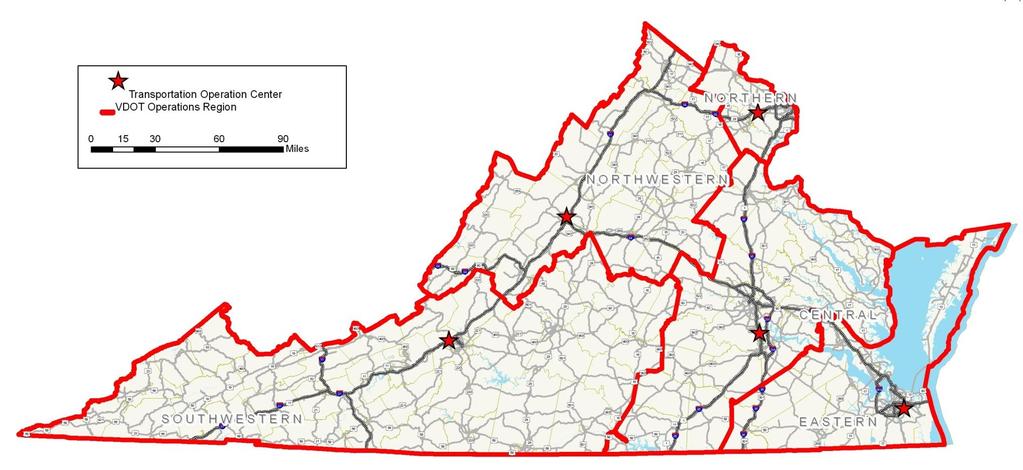
2 Virginia

3 Virginia's Highway System 57,867 miles of statemaintained system 1,118 miles of Interstate 8,111 miles of Primaries 48,305 miles Secondaries 3

4 More than just roads VDOT is also responsible for 12,603 bridges + 4 underwater crossings in the Hampton Roads area 2 mountain tunnels 3 toll roads 1 toll bridge 4 ferry services 41 safety rest areas 10 welcome centers More than 100 commuter parking lots 4
5 Operations Directorate Chief of System Operations Maintenance Operations and Security Operations Planning Traffic Engineering
6 Traffic Engineering Division State Traffic Engineer Safety Highway Improvements Work zones Crash Records Engineering Studies and Data Analysis Traffic Monitoring Data Analysis Studies System Analysis Traffic Control Devices Traffic Systems Management Electrical Systems management Special Signing TCD Engineering Program Planning & contracts
7 Roundabouts: The Virginia Experience Roundabout Program Formally Established in Virginia in 1997 Encouraged new roundabouts on construction projects Created centralized review committee Relied on FHWA guidance; Currently use Roundabouts: An Informational Guide Use aasidra for evaluations
8 Approval Process District Approves: Approach volumes <= 10,000 vpd Subdivisions Review Committee: 4 members representing TE, L&D & Planning State L&D engineer makes final decision 101 operating; 104 in planning stages
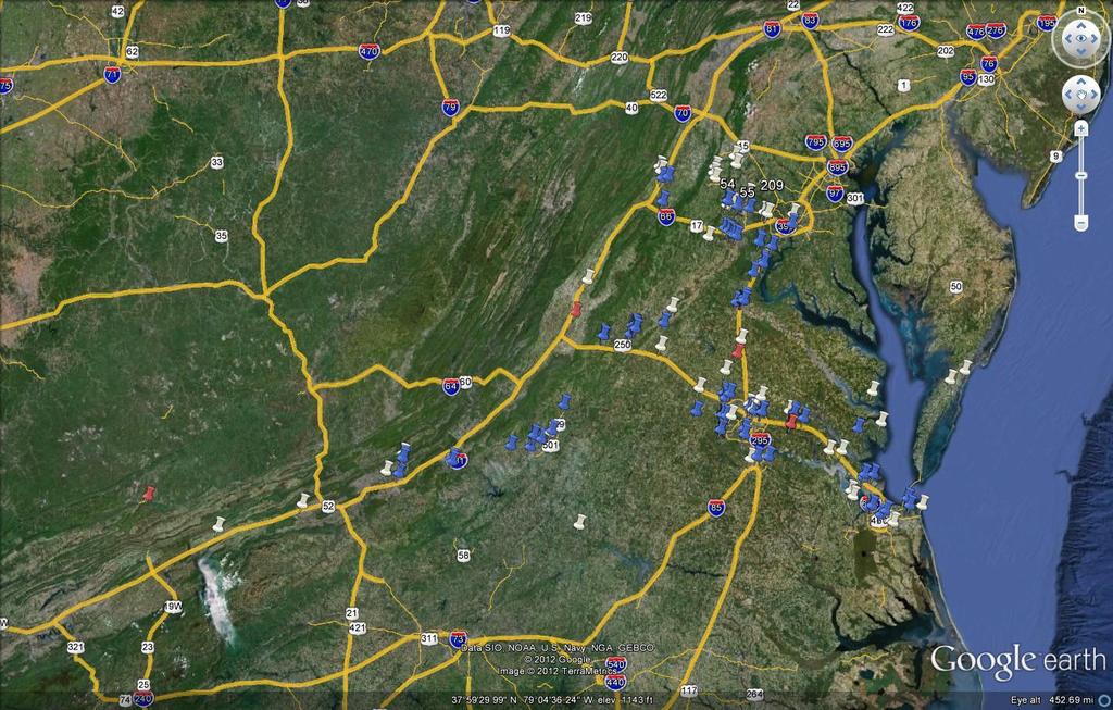
9 Google Earth Aerials Google Earth Link \\0501coitd1\tedpublic\Roundabouts\Roundabout.kml

10 Google Earth Aerials Google Earth Link \\0501coitd1\tedpublic\Roundabouts\Roundabout.kml
11 Design Features Follow Roundabout Design Guide Parking normally not allowed within functional area of roundabouts (bulb outs may be an exception) Recommend curbs on approaches and throughout roundabout to provide better containment of vehicles Prefer raised splitter islands but have allowed flush if no ped traffic. Have used exclusive right turn lanes but have concerns with merge points where ROW limits acceleration lane 11
12 Challenges Pedestrians and bicyclists All ped crossings comply with ADA requirements; designed to provide shortest walking distance possible. Use 6 wide raised splitter islands at the ped crossing point All ped crossings are located 20 upstream Sidewalk widths range from 5 up to 10 when shared use Recommend a minimum 2 landscaping strip between sidewalks and curb Bike lanes terminate 100 prior to the edge of the circulatory roadway; bikes can use curb cut ramps/sidewalks 12

13 Va Tech Campus

14 VUU City of Richmond
15 Challenges (continued) Access / driveways in close proximity Shift; Shortened splitter islands or used flush islands Will allow access to gas station only in rural, less congested area. Acquire parcel as last resort Trucks Mountable curbs used on truck aprons; Less mountable curbs used on approaches / departures from roundabout. For inside truck aprons, the slope should be similar to the roadway Outside truck aprons for easier right turns by large trucks Evaluations include auto turn tracking. 15

16 Christopher Newport University (Newport News)

17 Outside Truck Aprons

18 Challenges (continued) Landscaping Encourage landscaping as long as sight lines are maintained High Speed Approaches Lane narrowing such as low growth plants/raised Islands Signing Speed reductions In-lane rumble strips Lighting Advocate for lighting at each location; if cost prohibitive, we recommend retro-reflective edge line markers or Bollards 18
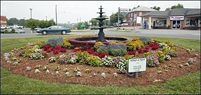
19 Amherst Roundabout

20 Challenges (continued) Traffic calming Different objectives than traditional roundabouts Use consistent yield at entry and deflection to maintain driver expectancy
21 Challenges (continued) Driver Education / Public Opinion Website / video Coordinate with DMV Pamphlets Simulation at public hearings Educate and Train VDOT designers, traffic engineers and planners Think beyond on-time and on-budget during project development Break out of signal comfort zone More evaluation needed 21

22 VDOT External Roundabout Web Page

23 Town of Amherst 1936/1940

24 Town of Amherst

25 Route 50/15 Loudoun County

26 White Oak Village
27 Questions?

28 Charlottesville Airport
29 Gloucester
30 Powhatan Courthouse
Roundabouts The Virginia Experience
 Roundabouts The Virginia Experience Purpose of Briefing Misconceptions Background on Roundabouts How they pertain to Virginia Definition & Operational Characteristics Roundabouts Vs. Traffic signals Considerations
ROUNDABOUTS/TRAFFIC CIRCLES
 GENERAL 1. Description This standard identifies minimum requirements that shall be met for Roundabouts and Neighborhood Traffic Circles in the design and construction of elements for Arlington County Horizontal
PEDESTRIAN ACCOMMODATIONS DPS 201 AT ROUNDABOUTS
 PEDESTRIAN ACCOMMODATIONS DPS 201 AT ROUNDABOUTS WHY THEY WORK FOR PEDESTRIANS IF DESIGNED CORRECTLY Separated sidewalks direct peds to crosswalks Splitter island Slow speed exit Truck apron Crosswalk
Designing for Pedestrian Safety
 Designing for Pedestrian Safety Roundabouts: How They Work for Pedestrians Presented by: Fred Ranck FHWA Resource Center Safety Design Engineer October 5, 2010 Roundabouts: Learning Objectives At the end
CHAPTER 3A. GENERAL PAGE CHAPTER 3B. PAVEMENT AND CURB MARKINGS PAGE
 Virginia Supplement to the 2009 MUTCD Revision 1 Page TC-3-1 PART 3. MARKINGS CHAPTER 3A. GENERAL PAGE Section 3A.01 Functions and Limitations Section 3A.02 Standardization of Application Section 3A.03
BETHEL ROAD AND SEDGWICK ROAD CORRIDOR STUDY
 DRAFT PLAN City Council Meeting August 14, 2017 STUDY AREA Sedgwick Corridor State Route 160, principal arterial with Class 3 access management designation, commuter and freight route, connection to SR
Safety at Unsignalized Intersections. Unsignalized Intersections
 Safety at FHWA Safety Focus Areas 2 National Statistics 3 National Statistics There were 41,059 highway fatalities in 2007. Where did they occur? Non-Intersections 79% About half of all crashes and half
Intersection Improvement: Sturgeon Road, Silver Avenue and Murray Park Road Roundabout. Welcome. Public Information Session
 Intersection Improvement: 1 Welcome WHY IS AN INTERSECTION IMPROVEMENT NEEDED? 2 Traffic volumes for Sturgeon Road, Silver Avenue and Murray Park Road exceed the capacity of the existing 4-way stop controlled
THE FUTURE OF THE TxDOT ROADWAY DESIGN MANUAL
 THE FUTURE OF THE TXDOT ROADWAY DESIGN MANUAL Kenneth Mora, P.E. (Design Division) 10/10/2017 Table of contents 1 2 Reduction in FHWA design controlling criteria Innovative Intersection Guidance 3-7 8-42
Update to DOTD Roundabout Design Policy
 Update to DOTD Roundabout Design Policy Roundabout In Louisiana Louisiana has 18 roundabouts in operation and 53 proposed History EDSM s or Engineering Directives and Standards set DOTD policies, procedures,
What Is a Complete Street?
 Session 5 Charleen Zimmer, AICP, Zan Associates May 5-7, 2010 What Is a Complete Street? May 2010 5-1 Not a Complete Street More of a Complete Street May 2010 5-2 Benefits of Complete Streets Safety for
Development of Guidelines for Bicycle Use of Controlled Access Facilities in Virginia
 Development of Guidelines for Bicycle Use of Controlled Access Facilities in Virginia VDOT Statewide Bicycle and Pedestrian Advisory Committee Fall Working Group Meeting October 30, 2013 Young-Jun Kweon,
Lynchburg District Update
 Lynchburg District Update Virginia Statewide Bicycle and Pedestrian Advisory Committee Spring Meeting May 16 th, 2017 David Cook Transportation Planner, VDOT Lynchburg District Table of Contents Active
South Carolina Department of Transportation. Engineering Directive
 South Carolina Department of Transportation Engineering Directive Directive Number: ED-22 Effective: December 16, 2009 Subject: References: Purpose: This Directive Applies to: Considerations for Bicycle
Who is Toole Design Group?
 2018 AASHTO Bike Guide Status Update NCHRP 15 60 Amalia Leighton Cody, PE, AICP & Kenneth Loen, PE Washington APWA October 4, 2018 Who is Toole Design Group? TDG is a full service engineering, planning
Information on display. Inside this handout. Triangle Area revisions. Project need displays. Preferred alternative on aerial maps
 Public information meeting #4 4 to 7 p.m., September 30, 2009 Hales Corners Welcome Thank you for attending this public information meeting for the WIS 100 Corridor Study. Your interest and comments are
Roundabouts are good for business
 Roundabouts are good for business What is a roundabout Rules 0f Roundabouts 1. Slow down when approaching a roundabout 2. Yield to vehicles in the roundabout 3. When clear, proceed right into the roundabout
Appendix 3 Roadway and Bike/Ped Design Standards
 Appendix 3 Roadway and Bike/Ped Design Standards OTO Transportation Plan 2040 4/20/2017 Page A3-1 Adopted Standards The adopted OTO Design Standards and Major Thoroughfare Plan are contained herein.
Roundabouts. By: Nezamuddin, Valparaiso University. February 19, 2015
 Roundabouts By: Nezamuddin, Valparaiso University February 19, 2015 Outline 1. Background on Roundabouts 2. Silhavy Rd. Corridor Improvement Project in Valparaiso, IN 3. 5-points Roundabout in Valparaiso,
INTERSECTION DESIGN. Bicycle Facility Workshop Intersections 4-1
 INTERSECTION DESIGN 4-1 Intersections Avoid unusual conflicts Provide direct path for cyclists, close to that of motor vehicles Bicyclists should be visible; their movements should be predictable Simple
INTERSECTION DESIGN TREATMENTS
 Designing for Bicyclist Safety INTERSECTION DESIGN TREATMENTS LEARNING OUTCOMES Understand intersection design options and features Select appropriate design feature for a bikeway in a given context C1
Route 29 Solutions Projects
 Route 29 Solutions Route 29 Solutions Projects www.route29solutions.org October 10, 2014 Route 29 Widening to Six Lanes Albemarle County This project will widen a 1.8-mile segment of Route 29 from four
Pedestrian Safety at Roundabouts
 Countermeasure Strategies for Pedestrian Safety Pedestrian Safety at Roundabouts Hillary Isebrands Federal Highway Administration January 6, 2016 Today s Presentation Introduction and housekeeping Audio
Agenda. Introduction to Roundabouts. Introduction to Roundabouts. Introduction to Roundabouts 6/6/2018
 PROPOSED PROJECT 161-003 SAFETY AND OPERATIONAL IMPROVEMENTS TO THE INTERSECTION OF ROUTE 106 (NEW CANAAN ROAD) AND BELDEN HILL ROAD Connecticut Department of Transportation Representatives Division of
Figure 3B-1. Examples of Two-Lane, Two-Way Marking Applications
 Figure 3B-1. Examples of Two-Lane, Two-Way Marking Applications A - Typical two-lane, two-way marking with passing permitted in both directions B - Typical two-lane, two-way marking with no-passing zones
Route 15 Congestion Report Findings
 Route 15 Congestion Report Findings Briefing To Loudoun County Board of Supervisors May 18, 2016 1 Overview: Previous Studies: Route 15 Corridor, Leesburg to Maryland Route 15 Congestion Report: Between
CR 30 / CR 11 and CR 30 / CR 11C Intersection Improvement Project. What Should We Build?
 CR 30 / CR 11 and CR 30 / CR 11C Intersection Improvement Project What Should We Build? Background CR 11 (Timberline) Donath Lake CR 30 CR 11C Stop controlled intersections Currently long delays (several
Acknowledgements. Mr. David Nicol 3/23/2012. Daniel Camacho, P.E. Highway Engineer Federal Highway Administration Puerto Rico Division
 Daniel Camacho, P.E. Highway Engineer Federal Highway Administration Puerto Rico Division Acknowledgements Mr. David Nicol Director, FHWA Office of Safety FHWA Office of Safety http://safety.fhwa.dot.gov/provencountermeasures/
Simulation Analysis of Intersection Treatments for Cycle Tracks
 Abstract Simulation Analysis of Intersection Treatments for Cycle Tracks The increased use of cycle tracks also known as protected bike lanes has led to investigations of how to accommodate them at intersections.
Small Town & Rural Multimodal Networks
 Small Town & Rural Multimodal Networks Fred Young, PLA Andrea Clinkscales, AICP, PMP Alta Planning + Design Funding Partners Project Team Existing Design Guidance AASHTO Flexibility Guide 2004 AASHTO Bike
Controlled. Semi-Controlled PAGE 01 CHAPTER 12 INTERSECTIONS
 PAGE 01 CHAPTER 12 INTERSECTIONS You will cross many intersections while driving. Intersections are especially dangerous because vehicles are crossing each other s driving path. Many crashes happen at
INDEX. Geometric Design Guide for Canadian Roads INDEX
 Acceleration lane, see Lanes, Acceleration Access, 8.1 Access Management and Functional Classification 8.2 Access Management by Design Classification 8.3 Access Configuration 8.4 Building Set-Back Guidelines
ADA & Public Rights of Way
 ADA & Public Rights of Way Overview of Current and Up-coming Requirements FDOT Design Training Expo 2012 Orlando, FL Dean Perkins, RA - ADA Coordinator Florida Department of Transportation Office of Design,
Roundabout Evaluations in Virginia: US 15/US 50 Gilberts Corner, VA SR 106/SR 634 Prince George County, VA
 Roundabout Evaluations in Virginia: US 15/US 50 Gilberts Corner, VA SR 106/SR 634 Prince George County, VA VDOT & FHWA Roundabout Workshop September 17, 2013 Chris Tiesler, PE Presentation Outline US 15/US
Access Management Regulations and Standards
 Access Management Regulations and Standards January 2014 Efficient highway operation Reasonable property access Concept of Access Management The way to manage access to land development while preserving
Chapter 4 TOOLBOX AND SAMPLE BIKE BOULEVARD LAYOUT
 Chapter 4 TOOLBOX AND SAMPLE BIKE BOULEVARD LAYOUT OVERVIEW This chapter describes a cohesive set of strategies to create a bicycle boulevard, namely to make streets safer and more efficient for bicycle
Road Diets and Roundabouts
 Road Diets and Roundabouts Paul Zykofsky, AICP Local Government Commission Sacramento, CA Classic Road Diet 4 to 3 lanes San Antonio TX On-street parking Median Bike Lanes Center Turn-Lane Seattle WA Road
Off-road Trails. Guidance
 Off-road Trails Off-road trails are shared use paths located on an independent alignment that provide two-way travel for people walking, bicycling, and other non-motorized users. Trails specifically along
Pedestrian & Bicycle Safety Innovations & Applications
 Pedestrian & Bicycle Safety Innovations & Applications County Engineers Association of Maryland Spring, 2017 Conference May 25, 2017 George Branyan Pedestrian Program Coordinator District Department of
Frequently Asked Questions
 Frequently Asked Questions Business US 190 in Copperas Cove From Avenue D to Constitution Drive What is access management? A. Access Management is a growing effort by government agencies to improve how
Work Zone Safety A Look At Best Practices. AASHTO SCOTE June 6, 2016
 Work Zone Safety A Look At Best Practices AASHTO SCOTE June 6, 2016 1 Work Zone Safety Innovations 2 Positive Protection Measures Pedestrian Accommodations Temporary Bicycle Facilities Work Area Lighting
LTAC: Katie Mencarini, Central & Hampton Roads streets and a fifteen minute debrief to discuss the findings. Participants walked along Mill Road
 Walkabout Summary On June 3, 2013, five participants met at Glen Allen Elementary School in Glen Allen, Virginia to take a closer look at the walking and biking network around the school. In addition to
Technical Summary Mini-Roundabouts
 Technical Summary Mini-Roundabouts FHWA-SA-10-007 Foreword This technical summary is designed as a reference for State and local transportation officials, Federal Highway Administration (FHWA) Division
Page 2D-10 Added the following language at the end of the paragraph under REFINING HORIZONTAL ALIGNMENT ; See Chapter 2A, Section 2A-6.
 ROAD DESIGN MANUAL REVISIONS January, 2017 CHAPTER 1B Page 1B-12 Added the following language (Definition); NORMAL CROWN - Undivided travel ways on tangents shall have a crown or high point in the middle
East Burke Transportation, Safety and Capacity Improvements
 East Burke Transportation, Safety and Capacity Improvements The purpose of this project is to increase mobility and improve safety for pedestrians, cyclists, and motor vehicles along VT Route 114 in the
$ 12" $#&%$ 86.) *1! *1 /3 )00, , (1* Neighborhood Traffic Calming Part 3 Solutions Bradley William Yarger, P.E.
 *1! *1 /3 )00, , (1* Neighborhood Traffic Calming Part 3 Solutions Bradley William Yarger, P.E.") $ 12" $#&%$ 86.)3+5+2 714 *1! *1 /3 )00,12 3.+ -0127 1, (1* Neighborhood Traffic Calming Part 3 Solutions by Bradley William Yarger, P.E. It is extremely tempting to jump to this step of the process thinking
$ 12" $#&%$ 86.)3+5+2 714 *1! *1 /3 )00,12 3.+ -0127 1, (1* Neighborhood Traffic Calming Part 3 Solutions by Bradley William Yarger, P.E. It is extremely tempting to jump to this step of the process thinking
Access Management Regulations and Standards for Minor Arterials, Collectors, Local Streets
 Access Management Regulations and Standards for Minor Arterials, Collectors, Local Streets September 2009 Paul Grasewicz Access Management Administrator Concept of Access Management The way to manage access
Route 47 (North Main Street) Reconstruction
 Reconstruction") TOWN OF SUNDERLAND Route 47 (North Main Street) Reconstruction Presented by Lou Rabito, P.E. Presented to Town of Sunderland June 11, 2018 Project Overview MassDOT Project No. 607245 Resurfacing and Related
TOWN OF SUNDERLAND Route 47 (North Main Street) Reconstruction Presented by Lou Rabito, P.E. Presented to Town of Sunderland June 11, 2018 Project Overview MassDOT Project No. 607245 Resurfacing and Related
Long Island Rail Road Expansion Project Floral Park to Hicksville
 Long Island Rail Road Expansion Project Floral Park to Hicksville Final Environmental Impact Statement Appendix 1-D Complete Streets Policy Checklist April 2017 0902ML PIN: Project Location: 18A-4 Floral
CURBSIDE ACTIVITY DESIGN
 5 CURBSIDE ACTIVITY DESIGN This chapter provides design guidance for separated bike lanes adjacent to curbside activities including parking, loading and bus stops. Typical configurations are presented
Multimodal Through Corridors and Placemaking Corridors
 68 Multimodal Through Corridors and Placemaking Corridors Corridors have different functions in a region. Some corridors are used to get smoothly and rapidly through a region or to get quickly to major
APPENDIX A: Complete Streets Checklist DRAFT NOVEMBER 2016
 APPENDIX A: Complete Streets Checklist DRAFT NOVEMBER 2016 Complete Streets Checklist MetroPlan Orlando s Complete Streets Checklist is an internal planning tool for staff to further implementation of
Vehicular turning and path of travel with a proposed curb bulb on the southwest corner of Mount Diablo Boulevard and Dewing Avenue.
 October 3, 2014 James Shively Stantec 100 California Street, Suite 1000, San Francisco CA 94111-4505 Subject: Traffic Study for Proposed Lafayette Chase Bank Dear Mr. Shively: Pursuant to your request,
Street Design Workshop. Existing cross section Traffic volumes Examine adjacent land uses You design future improvements
 Street Design Workshop Existing cross section Traffic volumes Examine adjacent land uses You design future improvements Primary Tools for Street Redesign Road diets Bike lanes Cycle tracks Trails Crosswalks
MUTCD, 2003 Edition. FHWA, US DOT March R
 MUTCD, 2003 Edition FHWA, US DOT http://mutcd.fhwa.dot.gov/index.htm March 2008 962R561200 1 Overview The traffic control devices (TCD) are very critical for the safe and efficient transportation of people
6.4 RECOMMENDED IMPROVEMENTS
 6.4 RECOMMENDED IMPROVEMENTS 6.4.1 Williston Road Recommendations While all alternatives would be an improvement over existing conditions, Alternative 3B is recommended over the others because it provides
Fleur Drive Reconstruction
 Fleur Drive Reconstruction October 29, 2018 1 Agenda: Fleur Drive Reconstruction Project Scope & Cost Overview Fleur Drive Cross Section Elements - Travel Lane Widths - Sidewalk Widths - Parkway Widths
NJDOT Complete Streets Checklist
 Background The New Jersey Department of Transportation s Complete Streets Policy promotes a comprehensive, integrated, connected multi-modal network by providing connections to bicycling and walking trip
Engineering Countermeasures for Transportation Safety. Adam Larsen Safety Engineer Federal Highway Administration
 Engineering Countermeasures for Transportation Safety Adam Larsen Safety Engineer Federal Highway Administration 360-619-7751 Adam.Larsen@DOT.GOV Countermeasure Selection Resources Manual for Selecting
CE576: Highway Design and Traffic Safety
 CE576: Highway Design and Traffic Safety Predicting Crash Frequency for Two-Lane Rural Highway Segments Cross Sectional Elements Ahmed Abdel-Rahim, Ph.D., P.E. Civil Engineering Department University of
Houma-Thibodaux Metropolitan Planning Organization STP<200K Funding Application APPLICATION
 APPLICATION HOUMA-THIBODAUX METROPOLITAN PLANNING ORGANIZATION (HTMPO) FOR SURFACE TRANSPORTATION PROGRAM (STP
PENNDOT HPMS DATA COLLECTION GUIDE. Bureau of Planning and Research Transportation Planning Division April 2016 (Updated March 2018)
") PENNDOT HPMS DATA COLLECTION GUIDE Bureau of Planning and Research April 2016 (Updated March 2018) State Street Dauphin County NOTES INTRODUCTION The purpose of this document is to provide you with some
PENNDOT HPMS DATA COLLECTION GUIDE Bureau of Planning and Research April 2016 (Updated March 2018) State Street Dauphin County NOTES INTRODUCTION The purpose of this document is to provide you with some
Legislative Update Williamsburg Residency
 Hampton Roads District Legislative Update Williamsburg Residency Jim Brewer, Resident Administrator 757-253-5140 Projects Under Way Warwick Boulevard Project http://www.warwickboulevard.org/ Contractors:
Walking Along the Road. Module 2
 Walking Along the Road Module 2 Learning Outcomes: 2-2 At the end of this module, you will be able to: Describe the operational and safety benefits of shoulders and sidewalks Select the appropriate design
Access Management in the Vicinity of Intersections
 Access Management in the Vicinity of Intersections FHWA-SA-10-002 Technical Summary Photo: Ralph Bentley (used with permission) 0 Access Management is: The design, implementation and management of entry
Traffic Engineering The Basics. Understanding the basic principles and how these drive the decisions regarding traffic management in Louisiana
 Traffic Engineering 101 - The Basics Understanding the basic principles and how these drive the decisions regarding traffic management in Louisiana Traffic Engineering 101 Purpose: To provide an overview
Technical Memorandum TO: Joel DeNunzio, P.E. Residency Administrator Charlottesville Residency FROM:
 M April 18, 2017 SUBJECT: Study Requests Batesville, VA Albemarle County R E E F E I SS G I ONAL EN N CO M DATE: ALIREZA FARHANGI Lic. No. 055515 O Jamison Brown Traffic Engineer Culpeper District Traffic
9.1 FUNCTIONAL HIGHWAY SYSTEMS IN URBANIZED AREAS Principal Arterial Interstate Principal Arterial Non-Interstate
 Greater Bozeman Area Transportation Plan (2007 Update) Chapter 9: Recommended Major Street Network & Roadway Typical Sections 9.1 FUNCTIONAL HIGHWAY SYSTEMS IN URBANIZED AREAS The discussion in this Chapter
Toward Zero Deaths. Regional SHSP Road Show Meeting. Virginia Strategic Highway Safety Plan. presented by
 Toward Zero Deaths Regional SHSP Road Show Meeting presented by Virginia Strategic Highway Safety Plan December 1, 2016 1 Welcome & Introductions Purpose of the Meeting Objectives & Key Outcomes Agenda»
2018 AASHTO BIKE GUIDE
 2018 AASHTO BIKE GUIDE Your presenter Rob Burchfield, PE NW Regional Engineering Director 35 years of experience in traffic engineering and bicycle facility design Toole Design Group Toole Design Group
City of Vallejo Traffic Calming Toolbox
 City of Vallejo Traffic Calming Toolbox June 1, 2013 Final Table of Contents Introduction... 1 Non-Physical Devices... 3 High-Visibility Crosswalk... 3 In Pavement Lighted Crosswalk... 4 Rapid Flashing
Balancing Operation & Safety for Motorized and Non-Motorized Traffic
 Balancing Operation & Safety for Motorized and Non-Motorized Traffic Brian Willham, PE, PTOE Iowa Director - MOVITE June 30, 2014 Learning Objectives: When & Why should we measure the performance of complete
Identify the letter of the choice that best completes the statement or answers the question.
 Chapter 02 - Practice Questions Multiple Choice Identify the letter of the choice that best completes the statement or answers the question. 1) No-parking zones often are near a. fire hydrants, curves,
Modal Interrelationships: A bicycle lane is proposed between Harrington Ave and Swanns Station Rd.
 DRAFT PROJECT PAGE July 12, 2007 Main St / Broadway Rd (SR 1579) Project Statement Project Recommendation: From Avent Ferry Rd (NC 42) to the Harnett County line, Broadway Rd/Main St is recommended to
Design Considerations for Complete Streets. The Kiewit Center for Infrastructure and Transportation
 Design Considerations for Complete Streets Objective Provide design geometrics and features that accommodate balanced operations of bicycles, pedestrians and vehicles on a complete street Cul-de-sacs,
Roundabout Prequalification Training. March 11, 2015
 Roundabout Prequalification Training March 11, 2015 Presenters American Structurepoint, Inc. Jeromy Grenard, PE, PTOE Craig Parks, PE Why Roundabouts? Everybody else is building them? They look cool? Circles
Small Area Study U.S. Route 220 and VA Route 615 Intersection. Bath County, Virginia
 Small Area Study U.S. Route 220 and VA Route 615 Intersection Bath County, Virginia Prepared by the Central Shenandoah Planning District Commission Final Report February 2018 Table of Contents 1. INTRODUCTION...
Road Traffic Signs in Germany
 Warning signs Road Traffic Signs in Germany General danger Curve left Curve right Double curve Double curve Accident hazard Sliding danger Winter sports along road Soft shoulder Rough road edge Steep upgrade
Appendix C. TRAFFIC CALMING PROGRAM TOOLBOX
 Appendix C. TRAFFIC CALMING PROGRAM TOOLBOX PHASE I...2 Do Not Enter Sign...3 One-Way Sign...4 Turn Prohibition...5 Pavement Markings...6 Speed Monitoring Trailer...7 Neighborhood Speed Watch...8 Police
Hampton Roads Pedestrian and Bicycle Advisory Committee
 Hampton Roads Pedestrian and Bicycle Advisory Committee Virginia Bicycle and Pedestrian Advisory Committee April 22, 2015 Carl E. Jackson, AICP Transportation Planning Specialist Hampton Roads District
INDOT Complete Streets Guideline & Policy
 INDOT Complete Streets Guideline & Policy INTRODUCTION The Complete Streets guidelines build upon multiple efforts and promote a multimodal transportation system that is integrated and sustains land use
Access Management Regulations and Standards
 Access Management Regulations and Standards Efficient highway operation Reasonable property access Concept of Access Management The way to manage access to land development while simultaneously preserving
Mini and Compact Roundabouts:
 Planning & Design of Mini and Compact Roundabouts: Scalability of Roundabouts Blair C. Perry, PE ATPA 2018 Annual Conference March 8, 2018 Traditional Single Lane Roundabouts Typically 130-180 diameter
Design Public Hearing MassDOT Project # February 19, 2015 Chatham Town Hall Annex 7:00 P.M.
 Design Public Hearing MassDOT Project #606596 February 19, 2015 Chatham Town Hall Annex 7:00 P.M. Overview Process to date Project goals Data collection results Existing conditions Alternative analysis
TRAFFIC CALMING TOOLBOX. For the residents of the City of Decatur, Georgia
 TRAFFIC CALMING TOOLBOX For the residents of the City of Decatur, Georgia 2 City of Decatur Traffic Calming Toolbox Public Works Department 2635 Talley Street Decatur, GA 30030 404.377.5571 3 Welcome to
What Engineering Can Do for You! Low Cost Countermeasures for Transportation Safety
 What Engineering Can Do for You! Low Cost Countermeasures for Transportation Safety Adam Larsen Safety Engineer Federal Highway Administration 360-619-7751 Adam.Larsen@DOT.GOV Adam Larsen TTP Safety Engineer
Broadway Complete Streets Project
 Broadway Complete Streets Project Megan Johnson, P.E. Associate Civil Engineer James Pangburn, P.E. Consultant Project Manager After the construction of the highway system, Broadway was cut off
PEDESTRIAN CROSSING TREATMENTS
 PEDESTRIAN CROSSING TREATMENTS BEST PRACTICES Presented by: Doug Enderson, P.E., PTOE Cody Salo, P.E. 1 PRESENTER INTRODUCTIONS Doug Enderson, P.E., PTOE Ped Crossing Experience: ADA Design-Build ADA Inventory
PENNDOT HPMS DATA COLLECTION GUIDE
 PENNDOT HPMS DATA COLLECTION GUIDE Bureau of Planning and Research April 2016 (Updated September 2017) State Street Dauphin County INTRODUCTION The purpose of this document is to provide you with some
Highway 93 South Corridor. Planning
 Highway 93 South Corridor 1 Planning Suitable for all categories business and personal presentation, eaque ipsa quae ab illo inventore veritatis et quasi architecto Check It Out Steering Committee Meeting
Walkability Audit Scores and Comments Lacey, Tumwater, and Olympia, WA September 2012
 Walkability Audit Scores and Comments Lacey, Tumwater, and Olympia, WA September 2012 The U.S. Environmental Protection Agency (EPA) provided technical assistance to Thurston Regional Planning Commission
CITY OF SARATOGA SPRINGS PEDESTRIAN CROSSING TOOLBOX
 CITY OF SARATOGA SPRINGS PEDESTRIAN CROSSING TOOLBOX This toolbox is to be used to guide pedestrian crossing improvements within the City of Saratoga Springs. Details for each crossing type are provided.
Columbia Pike Implementation Team (CPIT) Meeting
 Meeting") Columbia Pike Implementation Team (CPIT) Meeting November 30, 2010 Agenda Introductions / Purpose of Meeting Review of project goals Multimodal project: 10% street design between the curbs Discussion Multimodal
Columbia Pike Implementation Team (CPIT) Meeting November 30, 2010 Agenda Introductions / Purpose of Meeting Review of project goals Multimodal project: 10% street design between the curbs Discussion Multimodal
DRAFT. A fifth objective, other considerations, has been added to capture considerations not captured by the four primary objectives.
 TECHNICAL MEMORANDUM Albany - Washington Avenue Traffic Calming Evaluation Matrix of Conceptual Alternatives Date: May 17, 2017 Project #: 17356 To: Aleida Andrino-Chavez From: Laurence Lewis, Sara Muse,
10.0 CURB EXTENSIONS GUIDELINE
 10.0 CURB EXTENSIONS GUIDELINE Road Engineering Design Guidelines Version 1.0 March 2017 City of Toronto, Transportation Services City of Toronto Page 0 Background In early 2014, Transportation Services
Traffic Signs and Signals
 CHAPTER FOUR Traffic Signs and Signals Traffic signs control traffic flow, making streets and highways safer for drivers, bicyclists and pedestrians. These signs, which are posted by the Indiana Department
Fiscal Year 2017 Bicycle and Pedestrian Metric Report
 Fiscal Year 2017 Bicycle and Pedestrian Metric Report November 2017 In 2015, the Virginia Department of Transportation s (VDOT) implementation of the 2004 Commonwealth Transportation Board s (CTB) Policy
NCHRP Superelevation Criteria for Sharp Horizontal Curves on Steep Grades. Research Team: MRIGlobal Pennsylvania State University
 NCHRP 15-39 Superelevation Criteria for Sharp Horizontal Curves on Steep Grades Research Team: MRIGlobal Pennsylvania State University Objective and Scope Develop superelevation criteria for sharp horizontal
New Jersey Department of Transportation. Complete Streets Summit Shukri Abuhuzeima NJDOT-Local Aid
 New Jersey Department of Transportation Complete Streets Summit 10-24-2017 Shukri Abuhuzeima NJDOT-Local Aid Grant Resources State Funded Programs Funding Levels Funding appropriated for FY 2017 State
Item to be Addressed Checklist Consideration YES NO N/A Required Description Complete Streets Guidelines
 Passaic County Complete Streets Checklist - Concept Development Project Name Item to be Addressed Checklist Consideration YES NO N/A Required Description Complete Streets Guidelines Existing Plans Have