AMMO Field Data Collection Manual
|
|
|
- Maximilian Chandler
- 6 years ago
- Views:
Transcription

1 AMMO Field Data Collection Manual June 2002 Montana Department of Transportation Maintenance Division
2 Introduction Table of Contents Page Maintenance Activities. 3 Procedures 4 List. 5 Field Data Collection Form. 6 Roadside Drainage Structures. 7 Fences 9 Litter 10 Mowing 11 Noxious Weeds. 12 Nuisance Vegetation. 13 Paths and Sidewalks. 14 Slopes and Ditches 15 Roadway Debris 17 Sweeping. 19 Traffic Safety Crash Barriers.. 21 Guide Signs.. 22 Highway Lighting.. 23 Highway Traffic Signals 24 Pavement Striping 25 Pavement Symbols.. 27 Protective Barriers 28 Regulatory/Warning Signs.. 30 Roadside Delineation 32 2
3 Introduction An integral component of MDT s Accountability for Montana s Maintenance Operations (AMMO) process is periodic field condition surveys. These surveys assess the current service levels for a variety of highway maintenance activities. The purpose of this manual is to provide guidance and consistency for data collection throughout the state. Maintenance Activities Twenty-five distinct maintenance activities have been identified to be assessed through the AMMO process. These 25 activities have been grouped into five areas: Rest Areas, Roadside, Roadway, Traffic Safety, and Winter Maintenance. Most of these activities can only be assessed through periodic field surveys. However, a few of the activities do not require field assessment because of other data collection activities that occur within the agency. The following is a list of all 25 maintenance activities categorized in the five groups. The list identifies those activities requiring condition surveys in the field. Group Activity Field Assessment Rest Area Rest Area Operations No Roadside Drainage Structures Yes Roadside Fences Yes Roadside Litter Yes Roadside Mowing Yes Roadside Noxious Weeds Yes Roadside Nuisance Vegetation Yes Roadside Paths and Sidewalks Yes Roadside Slopes and Ditches Yes Roadway Debris Yes Roadway Minor Roadway Repair No Roadway Pavement Projects No Roadway Shoulders No Roadway Sweeping Yes Traffic Safety Crash Barriers Yes Traffic Safety Guide Signs Yes Traffic Safety Highway Lighting Yes Traffic Safety Highway Traffic Signals Yes Traffic Safety Intelligent Transportation Systems No Traffic Safety Pavement Striping Yes Traffic Safety Pavement Symbols Yes Traffic Safety Protective Barriers Yes Traffic Safety Regulatory/Warning Signs Yes Traffic Safety Roadside Delineation Yes Winter Maint Winter Maintenance Operations No 3
4 Procedures The following procedures should be followed when rating the roadway segments: 1) For each Divisional team, headquarters will provide a list of statistically valid, randomly selected roadway segments to be assessed. For each roadway segment, your team will be provided with three data forms; two working copies for each team member and a final master copy to be submitted to headquarters 2) In addition to a list of roadway segments and data collection forms, each team will be provided with maps depicting the location of the segments to be assessed. The team members can use these maps to help plan the best order in which to assess their segments. 3) Using reference posts and the vehicle s DMI, locate and mark the beginning and ending points for each segment with spray paint. For interstates, only assess the side of the roadway indicated on the segment list. For instance, if the segment to be assessed is the eastbound side of I-90 at milepost 300, only assess the eastbound portion of the interstate and the corresponding right-of-way flanking the eastbound section. DO NOT assess the westbound portion of the interstate. 4) Do not rate an assigned roadway segment if any of the following exist: a. Any portion of the roadway is under construction b. Any portion of the segment contains a structure 5) When rating a segment, each team member should do so independently. If a feature does not exist within the segment, the data collection form should be marked with a N/A in the appropriate field. Upon completion of the independent assessment, the team should review and compare their ratings. Once the team members have agreed on the final ratings for the segment, the master copy of the rating form for that segment should be completed. 6) Upon completion of the field assessment forms, please send them via deadhead mail to: Jeff Sillick, Helena Maintenance 4
5 List The following equipment is recommended for properly performing field data collection for the AMMO process: Clipboards, pencils, erasers AMMO Field Data Collection Manual Montana s Noxious Weed Identification Guide Rating forms Maps Measuring wheel Calculator Flashlight Tape measure Spray paint Pavement marking retroreflectometer Hardhat and vest Portable Survey Crew sign (optional) 5
6 AMMO Field Data Collection Form Site Number Corridor Route Reference Post Roadside Drainage Structures Total num. D.S. Number deficient Fences Total linear ft of fencing Linear feet deficient Litter Total linear ft of roadside Pcs. of litter observed Mowing Total Linear ft of mow zone Linear ft deficient Noxious Weeds Total sq ft of roadside Sq ft of infestation Nuisance Vegetation Total linear ft of roadside Linear ft deficient Paths & Sidewalks Total Linear ft of paths Linear ft deficient Slopes & Ditches Total linear ft of S & D Linear ft deficient Roadway Debris Total linear ft of roadway Number of pcs of debris Sweeping Total linear ft of roadway Linear ft deficient Data Collectors Date Total Time Traffic Safety Crash Barriers Total num. crash barriers Total deficient Guide Signs Total num. guide signs Total deficient Highway Lighting Total num. lights Total deficient Traffic Signals Total num. signals Total deficient Pavement Striping Total linear ft of right edgeline Length deficient Reflectivity Total linear ft of centerline Length deficient Reflectivity Total linear ft of left edgeline Length deficient Reflectivity Pavement Symbols Total num pave. symbols Total deficient Protective Barriers Total linear ft of barriers Length deficient Reg/Warning Signs Total num reg/warn signs Total deficient Roadside Delineation Total num delineators Total deficient Enter notes on back of form 6

7 Roadside Drainage Structures Any structure which provides a means of moving water from the roadway surface or under the roadway such as drop inlets, culverts, and flumes. Any portion of the drainage structure is obstructed by more than 25% with sediment and debris significantly reducing the volume of flow, or Any portion of the structure is significantly damaged or deteriorated. Reporting Measure Total number of drainage structures Number of drainage structures below deficiency threshold Count and record all drainage structures within the segment. Assess and record the number of drainage structures below the deficiency threshold. Evaluate only those drainage structures within MDT s right-of-way. Flashlight Tape measure Examples Damaged and obstructed culvert. 7


8 Drop inlet with obstruction. Culvert obstructed by sediment significantly reducing flow. Culvert with significant structural damage. 8

9 Roadside Fences A fence is a MDT-maintained barrier installed along the edge of the right-of-way and designed to prevent access to the highway. Missing, damaged, or structurally deficient fences Reporting Measure Total linear feet of fencing Linear feet of fence missing or damaged Measure and record the total linear feet of fencing. Assess and record the total linear feet of fencing that is missing or damaged. Measuring Wheel Comments Assessment for this activity should be limited to Interstates. Although MDT maintains fences on a few routes other than on the Interstate System, these locations are scattered and not well documented. Examples Damaged fence. 9

10 Roadside Litter Litter is any domestic or commercial refuse, debris, garbage, or rubbish deposited within the highway right-of-way making the area aesthetically displeasing. Litter visible at posted speed limit. Reporting Measure Total Linear feet of roadside Number of pieces of litter observed at posted speed limit While one member of the assessment team drives the roadway segment at the posted speed limit, the other team member should count and record the total pieces of litter observed from the passenger seat. This should be conducted for both sides of the roadbed. None Comments The assessment methodology requires driving the segment at the posted speed limit because this most accurately reflects the experience of the traveling public. Undoubtedly, additional litter will be observed when walking the segment, but do not record observations made on foot. Examples Litter along highway right-ofway visible at posted speed limit. 10

11 Roadside Mowing Mowing is the act of vegetation management of the right-of-way through mechanical means. Right-of-way vegetation adjacent to the paved surface greater than 18 in height within the established mowing zone. Reporting Measure Total linear feet of mowing zone Linear feet of mowing zone greater than 18 in height Measure and record the total linear of mowing zone. Assess and record the total linear feet of the mowing zone greater than 18 in height. Tape measure Comments Some segments of MDT s right-of-way are under haying contracts. For those segments under contract, make a note on the form and do not assess this activity. Examples Right-of-way vegetation greater than 18 inches in height. 11
12 Roadside Noxious Weeds A noxious weed is any plant on the Montana noxious weed list which when established is highly destructive, competitive, or difficult to control by cultural or chemical practices. Presence of Russian Knapweed, Spotted Knapweed, Diffuse Knapweed, Dalmatian Toadflax, and/or Leafy Spurge. Reporting Measure Total square feet of roadside area Total square feet of noxious weed infestation Survey the roadside and determine the presence of any of the five noxious weeds listed above. Measure the square feet of any infestations. The total square feet of infestation should not exceed the total square feet of roadside. Measuring Wheel Calculator Montana s noxious weeds identification guide Comments Noxious weed identification can be difficult. It is important to fully utilize Montana s noxious weeds identification guide when assessing roadsides for the presence of noxious weeds. 12


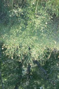

13 Examples Russian Knapweed Spotted Knapweed Diffuse Knapweed 13


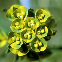
14 Dalmatian Toadflax Leafy Spurge 14

15 Roadside Nuisance Vegetation Unwanted vegetation on or adjacent to paved surfaces creating a safety hazard by either impeding the clear zone or obstructing sight distances. Presence of nuisance vegetation Reporting Measure Total linear feet of roadside Linear feet of nuisance vegetation Measure and record the total linear feet of roadside. Assess and record the total linear feet of nuisance vegetation. Measuring Wheel Examples Nuisance vegetation adjacent to paved surface impeding the clear zone. 15

16 Roadside Paths and Sidewalks Paths and sidewalks are completely separate paved surfaces designated for the exclusive use of bicycles and pedestrians with cross flows by motorists minimized. Presence of significant pavement distress or other deficiencies causing safety hazards Reporting Measures Total linear feet of paths and sidewalks Linear feet of deficient paths and sidewalks Measure and record the total linear feet of paths and sidewalks present within the segment. Assess and record the linear feet of deficient paths and sidewalks. Measuring Wheel Comments It may be difficult in some locations to know definitively whether paths and sidewalks are within MDT right-of-way. When in doubt, assume the facilities belong to MDT and perform the appropriate assessment. Examples Path with significant pavement distress resulting in a safety hazard. 16

17 Roadside Slopes & Ditches Slopes are the area from the edge of the paved surface to the toe of the slope. Ditches are open drainage areas designed to channel water away from the roadway. Slopes exhibiting significant erosion or slides. Ditches with impediments obstructing flow. Reporting Measures Total linear feet of slopes and ditches Linear feet of deficient slopes and ditches Measure and record the linear feet of all slopes and ditches within the segment. Assess and record the linear feet of slopes with significant erosion or slides. Assess and record the linear feet of ditches where water flow is obstructed (or would be if water were present). For purposes of this assessment, to be considered a ditch, the following must exist: It must be designed and constructed to carry water (not a natural swale), or It must be maintained as a ditch by Maintenance. Measuring wheel Examples Slope exhibiting significant erosion. 17

18 Ditch with significant impediments obstructing flow. 18

19 Roadway Debris Debris is any foreign object creating a safety hazard on the paved surface or within the clear zone. Debris on paved surfaces or within the clear zone creating safety hazards Reporting Measure Total linear feet of segment Number of distinct pieces of debris on paved surfaces or within the clear zone creating safety hazards Measure and record the total linear feet of roadway in the segment. Assess and record the total number of distinct pieces of debris on the paved surface or within the clear zone creating a safety hazard. Measuring wheel Comments Objects to be considered debris should not also be classified as litter. Litter does not pose a safety hazard, while debris does. Animal carcasses should be included among debris. Examples Debris on the paved surface creating a safety hazard. 19

20 Animal carcass within the clear zone creating a safety hazard. 20

21 Roadway Sweeping Sweeping is the act of mechanically removing excess dust, dirt, rocks, and sanding material from paved surfaces. Excess dust, dirt, rocks, and sanding material on paved surface Reporting Measure Total linear feet of roadway Linear feet of roadway below deficiency threshold Measure and record the total linear feet of roadway segment. Assess and record the total linear feet of roadway below the deficiency threshold. Measuring wheel Examples Excess sanding material on paved surface. 21

22 Excess dirt on paved surface obstructing pavement markings. 22

23 Traffic Safety Crash Barriers Crash barriers are barriers designed to absorb impact energy of a vehicle striking an object such as a bridge support, barrier, or guardrail end. Crash barriers damaged, malfunctioning, or missing Reporting Measure Total number of crash barriers Number of crash barriers damaged, malfunctioning, or missing Count and record all crash barriers within the segment. Assess and record the number of crash barriers below the deficiency threshold. None Examples Damaged crash barrier. 23

24 Traffic Safety Guide Signs Guide signs are essential to direct road users along streets and highways, to inform them of intersecting routes, to direct them to cities, towns, villages, or other important destinations, to identify nearby rivers and streams, parks, forests, and historical sites, and generally to give such information as will help them along their way in the most simple, direct manner possible. Worn, damaged, or missing guide signs. Auxiliary illumination malfunctioning. Reporting Measure Total number of guide signs Number of signs below deficiency threshold Count and record the total number of guide signs. Assess and record the number of guide signs below deficiency threshold. None Examples Damaged guide sign. 24
25 Traffic Safety Highway Lighting Highway lights are those devices installed to provide supplemental illumination to the highway surface. Damaged or malfunctioning highway lighting Reporting Measure Total number of highway lights Number of highway lights below deficiency threshold Count and record the total number of highway lighting facilities within the segment. Assess and record the number of lights damaged or malfunctioning. Since it is not possible to determine whether the lights are malfunctioning during daylight hours, check with the local Maintenance staff regarding performance of lighting. None Examples 25

26 Traffic Safety Highway Traffic Signals Highway Traffic Signals are power-operated traffic control devices by which traffic is warned or directed to take some specific action. Highway traffic signals include traffic control signals, pedestrian signals, emergency-vehicle traffic control signals, flashing beacons, and a variety of other specialized devices. Highway traffic signals with lamp outage, improper signal operations, improper crosswalk push button operation, or damage Reporting Measure Total number of distinct highway traffic signals Number of highway traffic signals with lamp outage, improper signal operations, improper crosswalk push button operation, or damage Count and record all distinct highway traffic signals within the segment. Assess and record the number of signals below the deficiency threshold. None Comments For the purposes of this assessment, count each distinct signal, crosswalk push button controls, advanced warning signals, and the like, as separate signals. For instance, at a typical intersection with four crosswalks, there may be up to eight crosswalk push button controls present. Record these eight controls as eight separate devises. Examples Damaged traffic signal controller. 26
27 Traffic Safety Pavement Striping Pavement Striping are those pavement markings characterized by longitudinal lines that serve to delineate the traveled way. The three most common types of striping includes center lines, lane lines, and edge lines, although other types of specialized striping also exists. Pavement markings missing, greater than 25% worn away, or below a 120 mcd/m2/lx (millicandelas per square meter per lux) reflectivity reading. Reporting Measure Total length of pavement markings o Right edgeline o Centerline o Left edgeline Length of line missing or below durability threshold o Right edgeline o Centerline o Left edgeline Reflectivity readings o Right edgeline o Centerline o Left Edgeline Count and record the total length of the right edgline, the centerline, and the left edgeline. Assess and record the length of each line that is below the durability threshold. Measure and record the average reflectivity for each line at two locations: one at the very beginning of the test section and one at the very end. Measuring wheel Pavement marking retroreflectometer 27


28 Examples Pavement stripe with low reflectivity. Pavement stripe more than 25% worn away. 28
 reflectivity reading.")
29 Traffic Safety Pavement Symbols Pavement symbols are those pavement markings characterized by various symbols and words such as stop bars, curb markings, crosswalks, and a variety of other specialized pavement markings. Pavement symbols missing, greater than 25% worn away, or below a 120 mcd/m2/lx (millicandelas per square meter per lux) reflectivity reading. Reporting Measure Total number of distinct pavement symbols Number of symbols below deficiency threshold Count and record the total number of distinct pavement symbols present in the segment. Assess and record the number of symbols below the deficiency threshold. Retroreflectometer Examples Pavement symbols with significant wear and low retroreflectivity. 29
30 Traffic Safety Protective Barriers Protective barriers serve to keep traffic away from dangerous areas such as water and steep drop-offs. Protective barriers include beam guardrail, cable guardrail, and concrete barrier walls (Jersey rail). Count as deficient any guardrail, including cable guardrail, damaged to the point that the structural integrity is compromised or the functionality is impaired. This would include broken or cracked posts, missing bolts, or where the face of the rail is deformed 6 inches or greater within any rail section or 12 foot length. Also, count as deficient any portion of rail that has been flattened even if it does not meet the 6 inches of deformation. Concrete barrier is counted as guardrail for the purposes of the AMMO survey. To be considered deficient, concrete barrier must be out of alignment by 6 inches or more, or the barrier surface facing traffic must exhibit spalling severe enough to snag a vehicle. Reporting Measure Total length of protective barriers Length of protective barriers below deficiency threshold Measure and record the total length of protective barriers within the segment. Assess and record the length of protective barrier below the deficiency threshold. Measuring wheel 30


31 Examples Damaged beam guardrail whose structural integrity is significantly impaired. Cracked guardrail post whose structurally integrity is significantly impaired. 31
32 Traffic Safety Regulatory/Warning Signs Regulatory signs are those signs used to inform road users of selected traffic laws or regulations and indicate the applicability of the legal requirements. Regulatory signs are installed at or near where the regulations apply. The signs clearly indicate the requirements imposed by the regulations and are designed and installed to provide adequate visibility and legibility in order to obtain compliance. Warning signs are those highway signs that call attention to unexpected conditions on or adjacent to a highway or street and to a situation that might not be readily apparent to road users. Warning signs alert road users to conditions that might call for a reduction of speed or an action in the interest of safety and efficient traffic operations. Worn, damaged, or missing regulatory/warning signs. Auxiliary illumination malfunctioning. Reporting Measure Total number of regulatory/warning signs Number of regulatory/warning signs below deficiency threshold Count and record the total number of regulatory/warning signs. Assess and record the number of regulatory/warning signs below deficiency threshold. None 32


33 Examples Sign exhibiting damage and insufficient retroreflectivity. Sign exhibiting damage. 33

34 Traffic Safety Roadside Delineation Roadside delineation consists of light-reflecting devices mounted at the side of the roadway, in series, to indicate the roadway alignment. Roadside delineation damaged, missing, or below standards Reporting Measure Total number of roadside delineators Number of roadside delineators damaged, missing, or below standards Count and record the total number of delineators within the segment. Assess and record the number of delineators below deficiency threshold None Examples Damaged roadside delineator. 34
35 Notes 35
ADOT Maintenance Data Collection Guide
 ADOT Maintenance Data Collection Guide January 1, 2009 Prepared for Arizona Department of Transportation Prepared by Jani Demaree and Cambridge Systematics, Inc. 100 CambridgePark Drive, Suite 400 ADOT
CHAPTER 1 STANDARD PRACTICES
 CHAPTER 1 STANDARD PRACTICES OBJECTIVES 1) Functions and Limitations 2) Standardization of Application 3) Materials 4) Colors 5) Widths and Patterns of Longitudinal Pavement Marking Lines 6) General Principles
Chapter V TRAFFIC CONTROLS. Tewodros N.
 Chapter V TRAFFIC CONTROLS www.tnigatu.wordpress.com tedynihe@gmail.com Lecture Overview Traffic markings Longitudinal markings Transverse markings Object markers and delineator Traffic signs Regulatory
Traffic Signs and Markings. Instructor: Dr. Yahya Sarraj Associate Prof. Of Transportation
 and Markings Instructor: Dr. Yahya Sarraj Associate Prof. Of Transportation Definition; A traffic sign is defined as a device mounted on a fixed or portable support whereby a specific message is conveyed
Appendix T CCMP TRAIL TRAFFIC & TRANSPORTATION DESIGN STANDARD
 Appendix T CCMP 3.3.4 TRAIL TRAFFIC & TRANSPORTATION DESIGN STANDARD 3.3.4 Trail Traffic and Transportation Design Multi-use trails have certain design standards, which vary depending on the agency that
Steps to Conducting a Complete Streets Assessment
 Steps to Conducting a Complete Streets Assessment Familiarize yourself with Complete Streets Read through the Complete Streets Assessment Guidelines. This will give you an idea of what Complete Streets
Pavement Markings (1 of 3)
") Pavement Markings (1 of 3) DESCRIPTION AND DEFINITION Disadvantages Relatively high cost (over typical Crash reduction as yet unknown painted edge line) No tactile effect The STOP AHEAD pavement marking
Pavement Markings (1 of 3) DESCRIPTION AND DEFINITION Disadvantages Relatively high cost (over typical Crash reduction as yet unknown painted edge line) No tactile effect The STOP AHEAD pavement marking
WYDOT DESIGN GUIDES. Guide for. Non-NHS State Highways
 WYDOT DESIGN GUIDES Guide for Non-NHS State Highways 2014 GUIDE FOR Non-NATIONAL HIGHWAY SYSTEM (Non-NHS) STATE HIGHWAYS PRESERVATION REHABILITATION RECONSTRUCTION INTRODUCTION This Guide is directed to
ADA on Construction. Guidance for Section C Plan Preparers
 ADA on Construction Guidance for Section C Plan Preparers Some impacts cannot be avoided and those impacts apply to residents, businesses, motorists, and pedestrians alike. However, good planning can minimize
Accommodating Pedestrians in the Work Zone
 Accommodating Pedestrians in the Work Zone Guidance for Section C Plan Preparers Some impacts cannot be avoided and those impacts apply to residents, businesses, motorists, and pedestrians alike. However,
Section 9A.07 Meaning of Standard, Guidance, Option, and Support
 2012 Edition Page 895 PART 9. TRAFFIC CONTROLS FOR BICYCLE FACILITIES CHAPTER 9A. GENERAL Section 9A.01 Requirements for Bicyclist Traffic Control Devices 01 General information and definitions concerning
(This page left intentionally blank)
") (This page left intentionally blank) 2011 Edition- Revision 2 Page 813 CHAPTER 9A. GENERAL Section 9A.01 Requirements for Bicyclist Traffic Control Devices 01 General information and definitions concerning
(This page left intentionally blank) 2011 Edition- Revision 2 Page 813 CHAPTER 9A. GENERAL Section 9A.01 Requirements for Bicyclist Traffic Control Devices 01 General information and definitions concerning
Traffic Control Devices
 533372 Highway Engineering Traffic Control Devices Traffic Control Devices o The media by which traffic engineers communicate with drivers o Every traffic law, regulation, or operating instruction must
Roadside Safety Proven Countermeasures. Emmett McDevitt Transportation Safety Engineer Federal Highway Administration
 Roadside Safety Proven Countermeasures Emmett McDevitt Transportation Safety Engineer Federal Highway Administration Safety Statistics On average each year 43,000 + people die in traffic related crashes.
PART 9. TRAFFIC CONTROLS FOR BICYCLE FACILITIES TABLE OF CONTENTS
 2006 Edition Page TC9-1 PART 9. TRAFFIC CONTROLS FOR BICYCLE FACILITIES TABLE OF CONTENTS SECTIONS CHAPTER 9A. Section 9A.01 Section 9A.02 Section 9A.03 Section 9A.04 Section 9A.05 Section 9A.06 Section
WYDOT DESIGN GUIDES. Guide for. NHS Arterial (Non-Interstate)
") WYDOT DESIGN GUIDES Guide for NHS Arterial (Non-Interstate) 2014 GUIDE FOR NATIONAL HIGHWAY SYSTEM (NHS) HIGHWAYS (NHS ARTERIALS, Non-Interstate) PRESERVATION REHABILITATION RECONSTRUCTION INTRODUCTION
WYDOT DESIGN GUIDES Guide for NHS Arterial (Non-Interstate) 2014 GUIDE FOR NATIONAL HIGHWAY SYSTEM (NHS) HIGHWAYS (NHS ARTERIALS, Non-Interstate) PRESERVATION REHABILITATION RECONSTRUCTION INTRODUCTION
Chapter 9 Maintenance
 Chapter 9: 9-1.0 Introduction Maintenance The maintenance of bikeways is closely linked to bicyclists safety and the preservation of the bikeway function and investment. Poor maintenance, resulting in
CHAPTER 8 STAKING SIGNALS AND LIGHTING FIELD GUIDE. 8.1 Staking Traffic Control Signal Systems
 CHAPTER 8 STAKING STAKING Correct staking of traffic control signal or lighting systems is critical to the appropriate placement of system components. 8.1 Traffic Control Signal Systems Locating the components
City of Roseville Section 13 Design Standards. _Bikeways January 2016 SECTION 13 BIKEWAYS
 SECTION 13 BIKEWAYS 13-1 GENERAL The City of Roseville bikeway standards are designed to insure that transportation and recreational bikeways are constructed in a manner that would provide a safe and comfortable
STAKING TRAFFIC CONTROL SIGNAL SYSTEMS
 Locating the components of a traffic control signal is not an exact science; many factors influence the location of the components. These factors include: lane widths, radii, pedestrian curb ramp requirements,
PLACEMENT OF SIGNS RECOMMENDED PRACTICES SUB-SECTION
 Page 1 of 6 RECOMMENDED PRACTICES PART SECTION SUB-SECTION HIGHWAY SIGNS GENERAL General Proper positioning of signs is an important element in the overall control of traffic within a roadway network.
California Manual on Uniform Traffic Control Devices
 California Manual on Uniform Traffic Control Devices FHWA s MUTCD 2009 Edition as amended for use in California 2012 Edition State of California Business, Transportation and Housing Agency Department of
Engineering Countermeasures for Transportation Safety. Adam Larsen Safety Engineer Federal Highway Administration
 Engineering Countermeasures for Transportation Safety Adam Larsen Safety Engineer Federal Highway Administration 360-619-7751 Adam.Larsen@DOT.GOV Countermeasure Selection Resources Manual for Selecting
What Engineering Can Do for You! Low Cost Countermeasures for Transportation Safety
 What Engineering Can Do for You! Low Cost Countermeasures for Transportation Safety Adam Larsen Safety Engineer Federal Highway Administration 360-619-7751 Adam.Larsen@DOT.GOV Adam Larsen TTP Safety Engineer
Figure 3B-1. Examples of Two-Lane, Two-Way Marking Applications
 Figure 3B-1. Examples of Two-Lane, Two-Way Marking Applications A - Typical two-lane, two-way marking with passing permitted in both directions B - Typical two-lane, two-way marking with no-passing zones
SPECIAL SPECIFICATION 7581 Performance Based Vegetation Management
 2004 Specifications CSJ 6216-60-001 SPECIAL SPECIFICATION 7581 Performance Based Vegetation Management 1. Description. This item will govern for complete vegetation management of highway rightof-way, including
MUTCD Part 6: Temporary Traffic Control
 MUTCD Part 6: Temporary Traffic Control OMUTCD English units are preferred. OHIO MANUAL OF UNIFORM TRAFFIC CONTROL DEVICES TABLE OF CONTENTS PREFACE INTRODUCTION TABLE OF CONTENTS PART 1. GENERAL Chapter
TRAFFIC CONTROLS FOR BICYCLE FACILITIES
 Part 9. TRAFFIC CONTROLS FOR BICYCLE FACILITIES TABLE OF CONTENTS Chapter 9A. GENERAL Page Section 9A.1 Requirements for Bicyclist Traffic Control Devices............................. 9A-1 9A.2 Scope.................................................................
Active Transportation Facility Glossary
 Active Transportation Facility Glossary This document defines different active transportation facilities and suggests appropriate corridor types. Click on a facility type to jump to its definition. Bike
ADDENDUM NUMBER ONE (1) For
 For") ADDENDUM NUMBER ONE (1) For OCCOQUAN REGIONAL PARK MULTIPURPOSE TRAIL Recreation Trails Program (RTP) Federal Highway Administration (FHWA) CFDA Number: 20.219 State Project Number: VRT-301 In Lorton,
ADDENDUM NUMBER ONE (1) For OCCOQUAN REGIONAL PARK MULTIPURPOSE TRAIL Recreation Trails Program (RTP) Federal Highway Administration (FHWA) CFDA Number: 20.219 State Project Number: VRT-301 In Lorton,
(This page left intentionally blank)
") (This page left intentionally blank) 2011 Edition - Revision 1 Page 553 Section 5A.01 Function CHAPTER 5A. GENERAL 01 A low-volume road shall be defined for this Part of the Manual as follows: A. A low-volume
(This page left intentionally blank) 2011 Edition - Revision 1 Page 553 Section 5A.01 Function CHAPTER 5A. GENERAL 01 A low-volume road shall be defined for this Part of the Manual as follows: A. A low-volume
Appendix Work Zone Traffic Control
 ppendix Work Zone Traffic Control The purpose of this appendix is to present basic guidelines for work zone traffic control and to supplement the Highway Work Zone Safety Checklist. This appendix presents
Low Volume Roads: Rural and Urban
 Rural Highway with less than 400 DT, and an Urban Residential Street with less than 400 DT and speeds of 0 mph or less. *Drawings Not To Scale *Drawings Not To Scale mndot.gov/fieldmanual Low Volume Low
Railroad Inspection Procedure Manual
 Railroad Inspection Procedure Manual Railroad Inspection Procedure Manual Table of Contents Introduction... 1 Inspection Report t For orm... 3 Instructions for Completing Inspection Report t For orms...
Fundamentals of Traffic Control Devices
 Fundamentals of Traffic Control Devices Traffic Engineering & Operations October 8, 2014 Raj Ponnaluri, Angela Wilhelm, and Christopher Lewis Agenda Agenda Signs Pavement Markings Signals Traffic Operations
NJDOT Complete Streets Checklist
 Background The New Jersey Department of Transportation s Complete Streets Policy promotes a comprehensive, integrated, connected multi-modal network by providing connections to bicycling and walking trip
TRAFFIC CONTROL DEVICES
 TRAFFIC CONTROL DEVICES SIGNS Temporary traffic control work zone signs include regulatory, warning and guide signs utilized to provide regulations, warnings and guidance information to road users impacted
Toward Zero Deaths Maintaining a Safer Roadway Workshop
 Toward Zero Deaths Maintaining a Safer Roadway Workshop Mike Marti, Primary Author SRF Consulting Group June 2010 Research Project Final Report #2010RIC03 Technical Report Documentation Page 1. Report
MUTCD Part 6G: Type of Temporary Traffic Control Zone Activities
 MUTCD Part 6G: Type of Temporary Traffic Control Zone Activities 6G.01 Typical Applications Each temporary traffic control (TTC) zone is different. Many variables, such as location of work, highway type,
TRAFFIC CONTROL DEVICES FOR LOW VOLUME ROADS
 PART 5. TRAFFIC CONTROL DEVICES FOR LOW VOLUME ROADS TABLE OF CONTENTS Chapter 5A. GENERAL Page Section 5A.1 Function............................................................... 5A-1 5A.2 Application............................................................
PART 5. TRAFFIC CONTROL DEVICES FOR LOW-VOLUME ROADS TABLE OF CONTENTS
 2005 Edition Page TC5-1 PART 5. TRAFFIC CONTROL DEVICES FOR LOW-VOLUME ROADS TABLE OF CONTENTS CHAPTER 5A. Section 5A.01 Section 5A.02 Section 5A.03 Section 5A.04 CHAPTER 5B. GENERAL Page Function...5A-1
New Measure A Expenditure Categories DEFINITIONS OF ELIGIBLE EXPENDITURES Adopted March 8, 2007
 New Measure A Expenditure Categories DEFINITIONS OF ELIGIBLE EXPENDITURES Adopted March 8, 2007 City Street and County Road Maintenance Program The preservation and keeping of public street and road rights-of-way
2004 Traffic and Safety Notes. Cross Reference between the Old Note Number and the New Note Number
 Michigan Department of Transportation 2004 Traffic and Safety Notes Cross Reference between the Old Note Number and the New Note Number OLD NEW Number Number Title (Prior to 2004) 1.1.1 101-Series General
Section 3A.04 Colors. Section 3B.10 Approach Markings for Obstructions
 Section 3A.04 Colors Markings shall be yellow, white, red, or blue, or purple. The colors for markings shall conform to the standard highway colors. Black in conjunction with one of the above colors shall
NOT TO SCALE PUBLIC WORKS STANDARD DETAILS CURB DETAILS DATE: MARCH 2013 FILE NAME: CURB.DWG
 NOT TO SCALE PUBLIC WORKS STANDARD DETAILS CURB DETAILS DATE: MARCH 2013 FILE NAME: CURB.DWG NOT TO SCALE PUBLIC WORKS STANDARD DETAILS SIDEWALK RAMPS DATE: MARCH 2013 FILE NAME: SIDEWALK RAMPS.DWG NOT
Traffic Control Inspection Checklist Segment:
 Traffic Control Inspection Checklist Segment: Simon Contractors Simon Contractors Originator: Description Reviewed by: Initials Date Distribution: Traffic Quality Manager, Site Assistant Traffic Manager
CHECKLIST 4: PRE-OPENING STAGE AUDIT
 CHECKLIST 4: PRE-OPENING STAGE AUDIT 4.1 General topics 4.1.1 Changes since previous audit; translation of design into practice General check: have any matters that have changed since a previous audit
RAILWAY LEVEL CROSSING CHECKLIST Road Safety Review of Railway Crossings
 RAILWAY LEVEL CROSSING CHECKLIST Road Safety Review of Railway Crossings Location: Crossing No. Date of On-Site Inspection: (Day) / / (Night) / / Weather: CHECKLIST 5. - GENERAL TOPICS Level of control
Chapter 4 On-Road Bikeways
 Chapter 4: 4-1.0 Introduction On-Road Bikeways This chapter provides guidelines to help select and design safe on-road bikeways. On-road bikeways include bicycle lanes, shared lanes, shoulders, and wide
4. TRAIL DESIGN GUIDELINES
 Trail Design Guidelines 4. TRAIL DESIGN GUIDELINES This chapter provides specific design guidelines for the Humboldt Bay Trail that are consistent with the guidelines currently observed in California and
Table of Contents. Introduction. Prompt List Arterials and Streets. Prompt List Interchange. Prompt List Intersections. Prompt List Limited Access
 Table of Contents Introduction Prompt List Arterials and Streets Prompt List Interchange Prompt List Intersections Prompt List Limited Access Prompt List MOT Prompt List Pedestrian Bicyclist Prompt List
Road Safety Facilities Implemented in Japan
 Road Safety Facilities Implemented in Japan 1 Road Safety Facilities 1.Guard Fence 2.Road Lighting 3.Other Road Safety Facilities 2 Road Safety Facilities 1.Guard Fence 2.Road Lighting 3.Other Road Safety
Shared Use Path Design
 12B-2 Design Manual Chapter 12 - Sidewalks and Bicycle Facilities 12B - Bicycle Facilities Shared Use Path Design A. Accessible Shared Use Path Design 1. General: Applicable portions from the following
WORK ZONE TRAFFIC CONTROL PROCEDURES
 WORK ZONE SETUP / REMOVAL WORK ZONE TRAFFIC CONTROL PROCEDURES When installing a work zone, install the advance warning signs on all approaches prior to installing the traffic control devices. Perform
AGENDA ITEM 6 D THOMASVILLE ROAD (HERMITAGE BOULEVARD TO LIVE OAK PLANTATION ROAD) ROADWAY SAFETY AUDIT
 ROADWAY SAFETY AUDIT") May 15, 2018 AGENDA ITEM 6 D THOMASVILLE ROAD (HERMITAGE BOULEVARD TO LIVE OAK PLANTATION ROAD) ROADWAY SAFETY AUDIT TYPE OF ITEM: Discussion STATEMENT OF ISSUE The Florida Department of Transportation
May 15, 2018 AGENDA ITEM 6 D THOMASVILLE ROAD (HERMITAGE BOULEVARD TO LIVE OAK PLANTATION ROAD) ROADWAY SAFETY AUDIT TYPE OF ITEM: Discussion STATEMENT OF ISSUE The Florida Department of Transportation
FOREST SERVICE HANDBOOK NATIONAL HEADQUARTERS (WO) WASHINGTON, DC
 WASHINGTON, DC") Page 1 of 14 FOREST SERVICE HANDBOOK NATIONAL HEADQUARTERS (WO) WASHINGTON, DC FSH 7709.55 - TRAVEL PLANNING HANDBOOK Amendment No.: 7709.55-2009-3 Effective Date: January 8, 2009 Duration: This amendment
Page 1 of 14 FOREST SERVICE HANDBOOK NATIONAL HEADQUARTERS (WO) WASHINGTON, DC FSH 7709.55 - TRAVEL PLANNING HANDBOOK Amendment No.: 7709.55-2009-3 Effective Date: January 8, 2009 Duration: This amendment
Design Criteria. Design Criteria
 F Design Criteria Design Criteria Ministry of Transportation Ministère des Transports DESIGN CRITERIA Page: 1 of 13 WORK PROJECT NO. N/A GO Bloomington Station TYPE OF PROJECT LOCATION Bloomington Road
CIRCULAR NO. O-13. Recommended Practices for Manual Protection of Highway/Railway Grade Crossings
 CIRCULAR NO. O-13 Recommended Practices for Manual Protection of Highway/Railway Grade Crossings Effective: October 1, 2004 CONTENTS 1. SCOPE 2. GENERAL PRINCIPLES 3. DEFINITIONS 4. PROTECTION REQUIRED
Quality. Standards. Methods to determine whether the various traffic control devices are Acceptable, Marginal, or Unacceptable.
 Quality Standards Quality Standards Methods to determine whether the various traffic control devices are Acceptable,, or Unacceptable. Contents Introduction.................................................6K-91
Appendix A. Knoxville TPO Greenway Signage Guidelines. Appendix A: Knoxville TPO Greenway Signage Guidelines Knox to Oak Ridge Greenway Master Plan
 Appendix A Knoxville TPO Greenway Signage Guidelines 75 Overview: Adequate signing and marking are essential on shared-use paths, especially to alert bicyclists to potential conflicts and to convey regulatory
TRAFFIC CONTROLS FOR BICYCLE FACILITIES
 PART IX. TRAFFIC CONTROLS FOR BICYCLE FACILITIES A. GENERAL 9A-1 Requirements for Bicyclist Traffic Control Devices Traffic control devices, whether they are intended for motorists or bicyclists, must
WORK ZONE TRAFFIC CONTROL PROCEDURES AND GUIDELINES FOR SCDOT MAINTENANCE ACTIVITIES
 WORK ZONE TRAFFIC CONTROL PROCEDURES AND GUIDELINES FOR SCDOT MAINTENANCE ACTIVITIES April 1, 2017 WORK ZONE TRAFFIC CONTROL PROCEDURES AND GUIDELINES FOR SCDOT MAINTENANCE ACTIVITIES Table of Contents
STREET and UTILITY REPAIRS WORK AREA PROTECTION GUIDE
 STREET and UTILITY REPAIRS WORK AREA PROTECTION GUIDE May 2006 Street and Utility Repairs Work Area Protection Guide TABLE OF CONTENTS 1. Introduction... 1 2. Typical Applications... 11 2.1 Use of Hand-Signaling
2016 FACT SHEET ENGINEERING STREET OPERATIONS. Engineering Street Operations net 2016 budget is $5,199,900 WHAT IS ENGINEERING STREET OPERATIONS?
 WHAT IS STREET OPERATIONS? This section maintains approximately 570 km of major, collector and residential roads throughout Saanich. Some of the major programs include road surface treatments (pothole
DEFINITIONS Activity Area - Advance Warning Area Advance Warning Sign Spacing Advisory Speed Approach Sight Distance Attended Work Space
 DEFINITIONS Activity Area - that part of a TTC zone activity area where the work actually takes place. It consists of the work space, traffic space and one or more buffer spaces. Advance Warning Area -
CHAPTER 16 PEDESTRIAN FACILITIES DESIGN AND TECHNICAL CRITERIA TABLE OF CONTENTS
 CHAPTER 16 PEDESTRIAN FACILITIES DESIGN AND TECHNICAL CRITERIA TABLE OF CONTENTS Section Title Page 16.1 General... 16-1 16.1.1 AASHTO Reference... 16-1 16.1.2 ADA Requirements... 16-1 16.2 Sidewalks...
APPENDIX B1. CROSS-REFERENCE GUIDE TO THE OHIO REVISED CODE
 Appendix B1. Cross-Reference Guide to the Ohio Revised Code Page B1-1 APPENDIX B1. CROSS-REFERENCE GUIDE TO THE OHIO REVISED CODE The Ohio Revised Code (O.R.C.) contains many laws which apply to the control
2009 Manual on Uniform Traffic Control Devices
 2009 Manual on Uniform Traffic Control Devices Tori Brinkly, PE Highway Safety Engineer WFL-FHWA April 20, 2010 Paragraphs are numbered. Standard Statements are bolded. Guidance statements are italicized.
Shoulders. Chapter 4: chapter contents
 Chapter 4: Shoulders chapter contents Characteristics of Well-Maintained Shoulders 73 Optimal Timing/Conditions for Maintenance 73 Shoulder Maintenance Issues 74 Shoulder Maintenance Activities 75 Repairing
PART A: IDENTIFICATION/LOCATION
 Appendix A. Quick Bus Stop Checklist QUICK BUS STOP CHECKLIST A1 Street Name: PART A: IDENTIFICATION/LOCATION A2 Nearest Cross Street (street name or landmark if mid-block): A3 A4 A5 Bus Route Direction:
General Design Factors
 Chapter 3: 3-1.0 Introduction General Design Factors Mn/DOT s goals include encouraging and accommodating safe bicycling. From a design perspective, these goals are achieved by first having an understanding
APPENDIX E Activity Defect Assignment
 APPENDIX E Activity Defect Assignment Activity Defect Pct Applicable 2010-ML - SHALLOW PATCHING (STN - 2010-TL - SHALLOW PATCHING (STN - 2020-ML - DEEP PATCHING (STN - 2020-TL - DEEP PATCHING (STN - 2030-ML
RURAL HIGHWAY SHOULDERS THAT ACCOMMODATE BICYCLE AND PEDESTRIAN USE (TxDOT Project ) June 7, Presented by: Karen Dixon, Ph.D., P.E.
 June 7, Presented by: Karen Dixon, Ph.D., P.E.") RURAL HIGHWAY SHOULDERS THAT ACCOMMODATE BICYCLE AND PEDESTRIAN USE (TxDOT Project 0-6840) June 7, 2016 Presented by: Karen Dixon, Ph.D., P.E., TTI Team: Kay Fitzpatrick, Raul Avelar, & Subasish Das Project
RURAL HIGHWAY SHOULDERS THAT ACCOMMODATE BICYCLE AND PEDESTRIAN USE (TxDOT Project 0-6840) June 7, 2016 Presented by: Karen Dixon, Ph.D., P.E., TTI Team: Kay Fitzpatrick, Raul Avelar, & Subasish Das Project
Quality Standards. Methods to determine whether the various. Marginal, or or Unacceptable. mndot.gov/fieldmanual. Standards.
 Quality Standards Methods to determine whether the various traffic traffic control control devices devices are Acceptable, are Acceptable,,, or or Unacceptable. Quality Standards mndot.gov/fieldmanual
18.1 Introduction Maintaining pedestrian-related Problems arising in the long term. infrastructure
 18 Maintaining the pedestrian network Maintaining the pedestrian network Maintenance in the short and long term Planning for pedestrians during maintenance works 18.1 Introduction Both pedestrian-related
10.0 CURB EXTENSIONS GUIDELINE
 10.0 CURB EXTENSIONS GUIDELINE Road Engineering Design Guidelines Version 1.0 March 2017 City of Toronto, Transportation Services City of Toronto Page 0 Background In early 2014, Transportation Services
ORANGE COUNTY TRAFFIC COMMITTEE. Speed Limit. Traffic Engineering. Deepthi Arabolu. Establish Speed Limit
 ORANGE COUNTY TRAFFIC COMMITTEE SUPERVISORIAL DISTRICT: 3 SUBJECT: LOCATION: INITIATED BY: INVESTIGATOR: REQUEST: Speed Limit Orange Park Boulevard; Orange Park Acres; TB 770-F7 & 800-F1, F3 Traffic Engineering
Driveway Design Criteria
 Design Manual Chapter 5 - Roadway Design 5L - Access Management 5L-4 Driveway Design Criteria A. General For efficient and safe operations, access drives and minor public street intersections can be improved
City of Vallejo Traffic Calming Toolbox
 City of Vallejo Traffic Calming Toolbox June 1, 2013 Final Table of Contents Introduction... 1 Non-Physical Devices... 3 High-Visibility Crosswalk... 3 In Pavement Lighted Crosswalk... 4 Rapid Flashing
October 2004 REVISIONS (2) SUPERELEVATION DEVELOPMENT 11.3(2)
 SUPERELEVATION DEVELOPMENT 11.3(2)") October 2004 REVISIONS (2) Chapter 11 HORIZONTAL ALIGNMENT SUPERELEVATION DEVELOPMENT 11.3(2) Chapter 12 VERTICAL ALIGNMENT VERTICAL CURVES PASSING SIGHT DISTANCE 12.5(2) VERTICAL CURVES STOPPING SIGHT
October 2004 REVISIONS (2) Chapter 11 HORIZONTAL ALIGNMENT SUPERELEVATION DEVELOPMENT 11.3(2) Chapter 12 VERTICAL ALIGNMENT VERTICAL CURVES PASSING SIGHT DISTANCE 12.5(2) VERTICAL CURVES STOPPING SIGHT
Introduction Methodology Study area and data collection Results and recommendation Conclusion References
 Introduction Methodology Study area and data collection Results and recommendation Conclusion References It is formal procedure for assessing accident potential and safety performance in the provision
STANDARD SPECIFICATIONS FOR PUBLIC WORKS CONSTRUCTION CITY OF MANITOWOC, WISCONSIN SECTION 900 TRAFFIC CONTROL
 SECTION 900 TRAFFIC CONTROL STANDARD SPECIFICATIONS FOR PUBLIC WORKS CONSTRUCTION CITY OF MANITOWOC, WISCONSIN SECTION 900 TRAFFIC CONTROL Section Number Title 901 GENERAL 902 MATERIALS, EQUIPMENT, AND
SCHOOL CROSSING PROTECTION CRITERIA
 CITY OF MADISON TRAFFIC ENGINEERING SCHOOL CROSSING PROTECTION CRITERIA January 2016 Adopted as Policy on August 31, 1976, by Common Council by Amended Resolution #29,540 Amended on September 14, 1976,
BICYCLE RULES OF THE ROAD
 ILLINOIS ILLINOIS ILLINOIS ILLINOIS ILLINOIS ILLINOIS ILLINOIS ILLINOIS BICYCLE RULES OF THE ROAD Jesse White Secretary of State Bicycle riding is a great way to get into shape and enjoy the outdoors.
Poor pavement condition Substandard Intersections. / Substandard bike/pedestrian/transit accommodations. Driveway access Environmental concerns
 Public Informational Meeting University Avenue (Allen Boulevard Segoe Road) March 23, 2011 City of Madison City of Middleton Village of Shorewood Hills Dane County Existing Roadway Conditions Poor pavement
Public Works Committee Meeting Richard E. Mastrangelo Council Chamber November 20, 2017
 Public Works Committee Meeting Richard E. Mastrangelo Council Chamber November 20, 2017 Purpose of Meeting Why are we here? Project Recap/Updates Project Limits/Segments Road Diet Concept Lessons Learned
Signs. signs, signals and road markings. in this chapter
 3 signs, signals and road markings in this chapter Signs regulatory signs school, playground and crosswalk signs lane use signs turn control signs parking signs reserved lane signs warning signs object
County of Spartanburg South Carolina
 County of Spartanburg South Carolina Traffic Calming Program June 2012 (Revised/Program on Hold) PURPOSE The potential negative impacts from vehicular traffic on residential roads have been a longstanding
Borough of Danville, PA Traffic Calming Program Guidelines
 Borough of Danville, PA Traffic Calming Program Guidelines Adopted by Borough Council on 1 INTRODUCTION Speeding Traffic is a major concern in the Borough of Danville because of its detrimental impacts
From Mile Zero to Target Zero the Dawson Creek Case Study
 From Mile Zero to Target Zero the Dawson Creek Case Study Raheem Dilgir, President, TranSafe Consulting Ltd. and Kevin Henderson, Manager of Planning and Development, City of Dawson Creek Paper prepared
Work Zone Traffic Safety
 Work Zone Traffic Safety Summary The Hazard: death or serious injury from being struck by vehicles or equipment in work zones. Who is at risk: streets/highways, utilities and other public works department
Manual Of Standard Traffic Signs And Pavement Markings Alberta
 Manual Of Standard Traffic Signs And Pavement Markings Alberta Traffic Accommodation and Control Alberta Highway Pavement Marking Guide and made available by Alberta Transportation, please see the following
Item to be Addressed Checklist Consideration YES NO N/A Required Description Complete Streets Guidelines
 Passaic County Complete Streets Checklist - Concept Development Project Name Item to be Addressed Checklist Consideration YES NO N/A Required Description Complete Streets Guidelines Existing Plans Have
Access Management Standards
 Access Management Standards Section 1: Application of Access Standards This chapter describes the Department's access management standards for access connections on the county roadway system. The standards
CHECKLIST 6: EXISTING ROADS: ROAD SAFETY AUDIT
 CHECKLIST 6: EXISTING ROADS: ROAD SAFETY AUDIT 6.1 Road alignment and cross-section 6.1.1 Visibility; sight distance Is sight distance adequate for the speed of traffic using the route? Is adequate sight
DRAFT. Scholls Ferry Road Conceptual Design Plan Technical Memorandum Multi-Modal Examples. Multnomah County 1600 SE 190th Avenue Portland, OR 97233
 Technical Memorandum Multi-Modal Examples Prepared for 1600 SE 190th Avenue Portland, OR 97233 December 2008 CITATION This project is partially funded by a grant from the Transportation and Growth Management
INDOT Complete Streets Guideline & Policy
 INDOT Complete Streets Guideline & Policy INTRODUCTION The Complete Streets guidelines build upon multiple efforts and promote a multimodal transportation system that is integrated and sustains land use
Date: April 4, Project #: Re: A Street/Binford Street Traffic/Intersection Assessment
 To: Peter Cavanaugh General Electric From: David Bohn, PE Ryan White, PE Date: April 4, 217 Project #: 13421. Re: / Traffic/Intersection Assessment Consistent with the Cooperation Agreement between the
CITY OF ELKO BICYCLE AND PATHWAY PLAN
 CITY OF ELKO BICYCLE AND PATHWAY PLAN INTRODUCTION: The City of Elko is intended to provide the basic framework for the development of a functional bicycle and pathway system for the community with connections
Ohio Department of Transportation Edition of the OMUTCD It s Here!
 Ohio Department of Transportation John R. Kasich, Governor Jerry Wray, Director 2012 Edition of the OMUTCD It s Here! June 6, 2012 Here are reasons why we have a Manual of Uniform Traffic Control Devices