Rail Station Fact Sheet Downtown Carrollton Station
|
|
|
- Roger Thompson
- 6 years ago
- Views:
Transcription
1 Rail Station Fact Sheet Downtown Carrollton Station Station Overview Downtown Carrollton Station is located at East Belt Line Road and Broadway Street near the historic Downtown Carrollton Square. The station opened in 2010 and is served by the DART Rail Green Line. Regional Rail Transit Lines
2 Rail Station Fact Sheet Downtown Carrollton Station Station Characteristics 1 Station Area Characteristics (1/2 mile radius) Address 1013 N. Denton Drive Demographics 3 City Carrollton Total Population 7,276 Agency Dallas Area Rapid Transit Population Density (pop/sq. mile) 957 Rail Line(s) Green Line Average Median Age 36 Corridor Northwest (NW) Average Median Income $48, Year Opened 2010 Park & Ride Spaces 251 Housing 3 Total Housing Units 2,297 Ridership 1 Housing Density (units/sq. mile) Avg. Weekday 679 Percent Occupied 90% 2015 Avg. Saturday 483 Percent Owner-Occupied 37% 2015 Avg. Sunday 292 Percent Renter-Occupied 63% 2014 On-Board Transit Survey: Access Mode to Station 2 Commute To Work 3 Bike 2.9% Percent Automobile 92.6% Drive Alone 15.2% Percent Drive Alone 73.7% Carpool 1.7% Percent Carpool 18.9% Walk 45.7% Percent Transit 1.4% Drop Off 21.3% Percent Bike 1.6% Other 0.8% Percent Walk 2.0% Transit Transfer 12.3% Percent Other 0.0% Percent Work from Home 2.4% Station Area Plans and Studies Percent Zero-Vehicle Households 6.7% Downtown Carrollton TOD (Carrollton Title Comprehensive Plan) Publisher City of Carrollton Traffic Survey Zone 2017 Employment Forecast 2 Year 2008 Total Jobs 13,892 Web Location showdocument?id=522 Job Density (jobs/sq. mile) 3,789 Sources: 1.Dallas Area Rapid Transit (DART), 2. NCTCOG, 3. U.S. Census American Community Survey 5 year estimates ( ) by block group
")


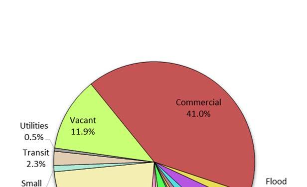
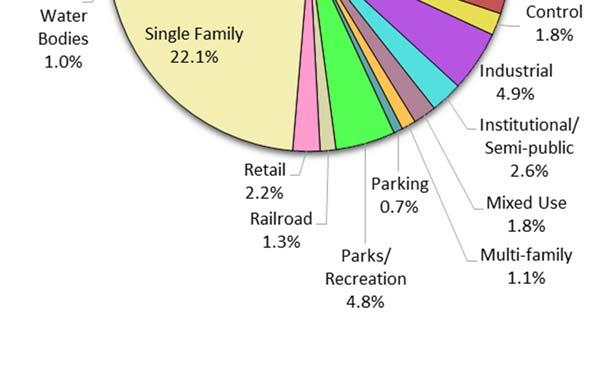
3 Land Use (2016) Downtown Carrollton Station Land Use Percentages


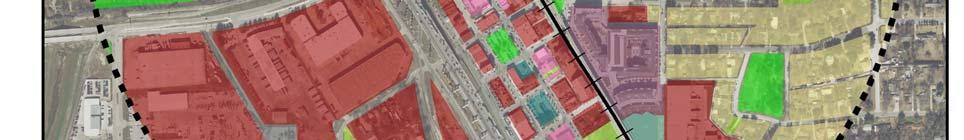
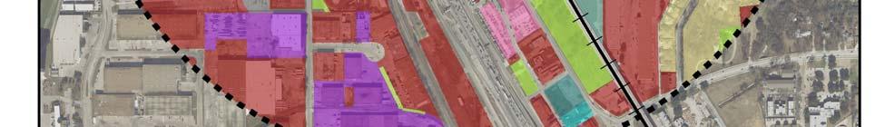
4 Zoning (2016) Downtown Carrollton Station Zoning Districts D Duplex Residential FWY Freeway HC Heavy Commercial LI - Light Industrial SF-7/16 - Single Family (Min. lot 7,000 sqft, Min home size 1,600 sqft) SF-8.4/16 Single Family (Min. lot 8,400 sqft, Min home size 1,600 sqft) SF-12/20 - Single Family (Min. lot 12,000 sqft, Min home size 2,000 sqft) Transit Center Zones Urban Core Historic Square Urban General Urban Fringe For more information on zoning, please visit the City of Carrollton Zoning website at: departments-g-p/planning-zoning


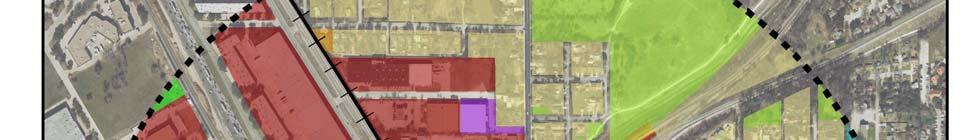
5 Pedestrian Routes to Rail - Downtown Carrollton Station Rail Stations Railroads COTTONWOOD CA L TA PI Legend WILLOW RANDOM KENEIPP Last Updated: February 2015 Existing sidewalk facilities within a 0.5 mile walk distance NORTH SIDE CR NT CE ES GR N EE TR AI Existing sidewalk facilities greater than a 0.5 mile walk distance L Existing sidewalk facilites that are disconnected due to a gap in the network Downtown Carrollton Station WALNUT CLINT OAK PERRY CENTURY Project Overview ROSEMON JACKSON MAIN ERIE SPRING CA MARYLAND BELT LINE RR UPFIELD HUTTON PARK AY DW 0.5 Miles The Pedestrian Routes to Rail study identifies all existing pedestrian facilities within a half-mile radius of existing light rail and commuter rail stations in the Dallas-Fort Worth region based on 2014 data. ArcGIS Network Analyst tool was used to identify continuous facilities that are less than or greater than a half-mile actual walking distance to a station. The maps also reflect existing facilities that are disconnected due to gaps or other barriers not allowing a continuous pedestrian route to a station. The maps do not reflect the condition or ADA compliance of the existing infrastructure. More information on the Routes to Rail study and methodology is available at: nctcog.org/routestorail ROS S OA S RT BE RO CROSBY FRANCIS BR 0.25 IFF GR R DE S ON 0 H 5T PARKSIDE MM N VA DUNN MYERS L H 4T E ST IN CARROLL OL M EL MA 0.5 Mile Station Buffer CROSBY


6 Bicycle Routes to Rail - Downtown Carrollton Station Last Updated: October 2016 Legend 2 I Rail Stations 0.5 Mile Station Buffer Rail Lines On-Street Bikeway, Existing \ ^ [ On-Street Bikeway, Planned 35E 2040 Veloweb Off-Street Path, Existing Off-Street Path, Planned Project Overview OA BR The Bicycle Routes to Rail study identifies all existing and planned bikeways in proximity to existing or under-construction light rail and commuter rail stations in the Dallas / Fort Worth region based on 2016 data. The maps reflect off-street paths (trails) and streets designated by local adopted master plans for dedicated bikeways (e.g. bike lanes, cycle tracks) located on the street. In accordance with the Texas Transportation Code, bicyclists have a right to the road. As such, the map does not reflect other roadways around the station that may have signed bike routes or by state law may be used by bicyclists. More information about the Routes to Rail study and methodology is available at: DW AY ST Downtown Carrollton Station 2 I BELT LINE RD nctcog.org/routestorail CROSBY RD 0.5 Miles [
Rail Station Fact Sheet University of Dallas Station
 Rail Station Fact Sheet University of Dallas Station Station Overview University of Dallas Station is located on John Carpenter Freeway and west of Loop 12 across from the University of Dallas in Irving.
Rail Station Fact Sheet DFW Airport North Station* (*station under construction with anticipated start of service in late 2018)
") Rail Station Fact Sheet DFW Airport North Station* (*station under construction with anticipated start of service in late 018) Station Overview DFW Airport North Station will be located on DFW nternational
Rail Station Fact Sheet DFW Airport North Station* (*station under construction with anticipated start of service in late 018) Station Overview DFW Airport North Station will be located on DFW nternational
Rail Station Fact Sheet CentrePort/DFW Airport Station
 Rail Station Fact Sheet CentrePort/DFW Airport Station Station Overview CentrePort/DFW Airport Station is located by Statler Boulevard at Breezewood Drive in Fort Worth. Free shuttles connect the station
Rail Station Fact Sheet UNT Dallas Station
 Rail Station Fact Sheet UNT Dallas Station Station Overview UNT Dallas Station is located on the east side of University Hills Boulevard in Dallas. t is connected by a walking path to the University of
Rail Station Fact Sheet Buckner Station
 Rail Station Fact Sheet Buckner Station Station Overview Buckner Station is located at the intersection of Buckner Boulevard and Elam Road in Dallas. The station opened in 2010 and currently serves as
Rail Station Fact Sheet CityLine/Bush Station
 Rail Station Fact Sheet CityLine/Bush Station Station Overview CityLine/Bush Station is located just south of the President George Bush Turnpike and east of US 75 in Richardson. The station opened in 00
Rail Station Fact Sheet Downtown Denton Transit Center
 Rail Station Fact Sheet Downtown Denton Transit Center Station Overview The Euline Brock Downtown Denton Transit Center is located on East Hickory Street at Railroad Street in Denton near the historic
Rail Station Fact Sheet North Side Station* (*station under construction with anticipated start of service in late 2018)
") Rail Station Fact Sheet North Side Station* (*station under construction with anticipated start of service in late 018) Station Overview North Side Station will be located near the intersection of North
Rail Station Fact Sheet North Side Station* (*station under construction with anticipated start of service in late 018) Station Overview North Side Station will be located near the intersection of North
Rail Station Fact Sheet Highland Village/Lewisville Lake Station
 ail Station Fact Sheet Highland Village/Lewisville Lake Station Station Overview Highland Village/Lewisville Lake Station is located on the IH 35 E Northbound Frontage oad at Garden idge Boulevard in Lewisville.
Rail Station Fact Sheet Spring Valley Station
 Rail tation Fact heet pring Valley tation tation Overview pring Valley tation is located near the intersection of West pring Valley Road and Lingco Drive in Richardson. he station opened in 2002 and is
Rail Station Fact Sheet North Richland Hills Smithfield Station* (*station under construction with anticipated start of service in late 2018)
") ail tation Fact heet North ichland Hills mithfield tation* (*station under construction with anticipated start of service in late 018) tation Overview North ichland Hills mithfield tation will be located
ail tation Fact heet North ichland Hills mithfield tation* (*station under construction with anticipated start of service in late 018) tation Overview North ichland Hills mithfield tation will be located
Rail Station Fact Sheet Morrell Station
 ail Fact Sheet Morrell verview Morrell is located on Morrell Avenue between its intersection with South Moore Street and Woodbine Avenue in allas. he station opened in 1996 and is served by the A ail Blue
Rail Station Fact Sheet Medical/Market Center Station
 ail tation Fact heet edical/arket Center tation tation verview edical/arket Center tation is located on outhwestern edical venue near edical istrict rive adjacent to Parkland Hospital in allas. he station
Rail Station Fact Sheet Camp Wisdom Station
 ail Station Fact Sheet Camp Wisdom Station Station verview Camp Wisdom Station is located in allas on the west side of Patrol Way north of Camp Wisdom oad. he station is next to the allas Police epartment
Rail Station Fact Sheet Southwestern Medical District/Parkland Station
 ail tation Fact heet outhwestern edical istrict/parkland tation tation verview outhwestern edical istrict/parkland tation is near Parkland emorial Hospital and the edical istrict rive and Harry Hines Boulevard
Tulsa Metropolitan Area LONG RANGE TRANSPORTATION PLAN
 Tulsa Metropolitan Area LONG RANGE TRANSPORTATION PLAN Indian Nations Council of Governments August 2005 CONTACTING INCOG In developing the Destination 2030 Long Range Transportation Plan, INCOG s Transportation
2010 Pedestrian and Bicyclist Special Districts Study Update
 2010 Pedestrian and Bicyclist Special Districts Study Update Pedestrian and Bicyclist Special Districts Program Overview H-GAC s Special Districts Program aims to provide strategic investments in pedestrian
Best Southwest Transportation Committee. North Central Texas Council of Governments Transportation Department
 Best Southwest Transportation Committee North Central Texas Council of Governments Transportation Department The The Regional Regional Veloweb Veloweb Review Review NCTCOG Bicycle and Pedestrian Program
ACTIVE TRANSPORTATION
 ACTIVE TRANSPORTATION Mobility 2040 Supported Goals Improve the availability of transportation options for people and goods. Support travel efficiency measures and system enhancements targeted at congestion
Chapter 14 PARLIER RELATIONSHIP TO CITY PLANS AND POLICIES. Recommendations to Improve Pedestrian Safety in the City of Parlier (2014)
") Chapter 14 PARLIER This chapter describes the current status and future plans for biking and walking in the City of Parlier. RELATIONSHIP TO CITY PLANS AND POLICIES The Parlier General Plan is the primary
Chapter 14 PARLIER This chapter describes the current status and future plans for biking and walking in the City of Parlier. RELATIONSHIP TO CITY PLANS AND POLICIES The Parlier General Plan is the primary
5 CIRCULATION AND STREET DESIGN
 5 CIRCULATION AND STREET DESIGN This chapter describes circulation and streetscape improvements proposed for the Northwest Chico Specific Plan Area. It includes detailed design specifications for existing
A copy of the draft plan is available at:
 To: From: Re: Mayor and City Council Patricia Nilsson, AICP, Comprehensive Planning Manager Boise Central Bench Neighborhood Pedestrian and Bicycle Plan Date: August 24, 2012 Requested Action Provide comments
San Mateo County Comprehensive Bicycle and Pedestrian Plan
 San Mateo County Comprehensive Bicycle and Pedestrian Plan August 26, 2010 Presented to the San Mateo County BPAC by Lauren Ledbetter, Alta Planning + Design in association with: Fehr & Peers Eisen Letunic
San Mateo County Comprehensive Bicycle and Pedestrian Plan Open House
 San Mateo County Comprehensive Bicycle and Pedestrian Plan Open House October 28, 2010 Presented to San Mateo County residents and interested parties by Lauren Ledbetter, Alta Planning + Design Matt Haynes,
2017 North Texas Regional Bicycle Opinion Survey
 2017 North Texas Regional Bicycle Opinion Survey Sustainable Development Program Kevin Kokes, AICP Public Meetings April, 2018 North Central Texas Council of Governments MPO for the Dallas-Fort Worth Region
CITY OF COCOA BEACH 2025 COMPREHENSIVE PLAN. Section VIII Mobility Element Goals, Objectives, and Policies
 CITY OF COCOA BEACH 2025 COMPREHENSIVE PLAN Section VIII Mobility Element Goals, Objectives, and Policies Adopted August 6, 2015 by Ordinance No. 1591 VIII MOBILITY ELEMENT Table of Contents Page Number
Chapter 13 ORANGE COVE
 Chapter 13 ORANGE COVE This chapter describes the current status and future plans for biking and walking in the City of Orange Cove. RELATIONSHIP TO CITY PLANS AND POLICIES The Orange Cove General Plan
Pedestrian Activity Criteria. PSAC March 8, 2011
 Pedestrian Activity Criteria PSAC March 8, 2011 Contents 1. Project Overview a) Revised schedule of PSAC hearings 2. Pedestrian Activity: Where walking is important a) Existing conditions (revisions based
Non-Motorized Transportation 7-1
 Non-Motorized Transportation 7-1 Transportation facilities no longer mean just accommodating a vehicle powered by a combustion engine. Pedestrian and non-motorized facilities are important modes of travel
APPENDIX A: Complete Streets Checklist DRAFT NOVEMBER 2016
 APPENDIX A: Complete Streets Checklist DRAFT NOVEMBER 2016 Complete Streets Checklist MetroPlan Orlando s Complete Streets Checklist is an internal planning tool for staff to further implementation of
Plant City Walk-Bike Plan
 Plant City Walk-Bike Plan Plant City Commute Mode Share 2.2% 1.4% 2.9% Drove alone 10.2% Carpooled Public transportation (0.1%) Walked Used a Bike (0.4%) 82.9% Taxicab, motorcycle, or other means Worked
FROM: CITY MANAGER DEPARTMENT: PLANNING AND COMMUNITY ENVIRONMENT DATE: OCTOBER 4, 2004 CMR:432:04
 TO: HONORABLE CITY COUNCIL FROM: CITY MANAGER DEPARTMENT: PLANNING AND COMMUNITY ENVIRONMENT DATE: OCTOBER 4, 2004 CMR:432:04 SUBJECT: FINANCE COMMITTEE RECOMMENDATION TO ADOPT TRANSPORTATION STRATEGIC
City of Charlottesville Bicycle and Pedestrian Master Plan Update
 City of Charlottesville Bicycle and Pedestrian Master Plan Update September 17, 2014 I. Welcome and meeting overview II. Project status update III. Network overview IV. Break-out groups Pedestrian Network
TRANSPORTATION ALTERNATIVES SET-ASIDE PROGRAM
 TRANSPORTATION ALTERNATIVES SET-ASIDE PROGRAM 2017 Call for Projects Recommendations for the North Central Texas Region Kevin Kokes Regional Transportation Council June 8, 2017 ELECTRONIC ITEM 4.1 FAST
Cotton Belt Corridor Regional Rail Project
 Cotton Belt Corridor Regional Rail Project Ridership July 2013 Prepared by URS Corporation Prepared for Dallas Area Rapid Transit General Planning Consultant Managed by URS Corporation Document Revision
NEWMARKET CENTRE Mobility Hub Profile
 Mobility Hub Profile Dundas Newmarket West-Bloor Centre Anchor Hub Gateway Hub N MOBILITY HUBS: Places of connectivity between regional and rapid transit services, where different modes of transportation
Traffic Safety Barriers to Walking and Bicycling Analysis of CA Add-On Responses to the 2009 NHTS
 Traffic Safety Barriers to Walking and Bicycling Analysis of CA Add-On Responses to the 2009 NHTS NHTS Users Conference June 2011 Robert Schneider, Swati Pande, & John Bigham, University of California
Regional trends in walking and biking Transport Chicago conference. June 9, 2017
 Regional trends in walking and biking Transport Chicago conference June 9, 2017 Overview CMAP & ON TO 2050 Trends in walking and biking since 2010 Findings from crash data and equity analysis Estimating
DON MILLS-EGLINTON Mobility Hub Profile
 Mobility Hub Profile Dundas Don Mills-Eglinton West-Bloor Anchor Hub Gateway Hub N MOBILITY HUBS: Places of connectivity between regional and rapid transit services, where different modes of transportation
DON MILLS-SHEPPARD Mobility Hub Profile
 DON MILLS-SHEPPARD Mobility Hub Profile Dundas Don Mills-Sheppard West-Bloor Anchor Hub Gateway Hub N MOBILITY HUBS: Places of connectivity between regional and rapid transit services, where different
SNCC Demographic Trends
 Employment Population SNCC Demographic Trends In 1970 the SNCC population was 10,040, accounting for roughly 3% of the County population In 2015, SNCC grew to 60,567 people, roughly 11% of the County population
In station areas, new pedestrian links can increase network connectivity and provide direct access to stations.
 The Last Mile Planning for Pedestrians Planning around stations will put pedestrians first. Making walking to stations safe and easy is important; walking will be a part of every rapid transit Accessible
Hennepin County Bicycle and Pedestrian Planning
 Hennepin County Bicycle and Pedestrian Planning 1 Value of bicycle and sidewalk systems Safety Livability Mobility Health Personal Finances Economic Sustainability Clean Air Recreation Parking and congestion
Regional Bicycle Barriers Study
 Regional Bicycle Barriers Study Executive Summary Background and Purpose The 2040 Transportation Policy Plan (TPP) sets policies for planning and investment direction in the transportation system in the
MASTER BICYCLE AND PEDESTRIAN PLAN
 VILLAGE OF NORTHBROOK MASTER BICYCLE AND PEDESTRIAN PLAN DRAFT PLAN OPEN HOUSE May 2, 2018 AGENDA 1. Community Engagement 2. Vision and Goals 3. General Structure of Plan 4. Recommendations Overview 5.
City Snapshot September 27, 2018
 1 City Snapshot September 27, 2018 Respondent Introduction Thank you for providing data for the PlacesForBikes City Rating program! The information you provide will be used to understand the progress your
Watertown Complete Streets Prioritization Plan. Public Meeting #1 December 14, 2017
 Watertown Complete Streets Prioritization Plan Public Meeting #1 December 14, 2017 Goals for Public Meeting Overview of MassDOT Complete Streets Funding Program Educate the community on Complete Streets
TOWN OF WILLIAMSTON, SC BICYCLE AND PEDESTRIAN MASTER PLAN TOWN OF WILLIAMSTON, SC BICYCLE AND PEDESTRIAN MASTER PLAN
 TOWN OF WILLIAMSTON, SC BICYCLE AND PEDESTRIAN MASTER PLAN Americans Want Choices 55% of Americans would rather drive less & walk more. Transit use is growing faster than population or highway travel.
Beyond First First Last Last Mile Strategies. APA National Conference April 3, 2016 Chelsea Richer, AICP Fehr & Peers
 Beyond First First Last Last Mile Strategies APA National Conference April 3, 2016 Chelsea Richer, AICP Fehr & Peers 1 Beyond First Last Mile Strategies APA National Conference Jeremy Klop, AICP, Fehr
Perryville TOD and Greenway Plan
 Perryville TOD and Greenway Plan Greenway Glossary Pathway: A bicycle and pedestrian path separated from motorized vehicular traffic by an open space, barrier or curb. Multi-use paths may be within the
DUNDAS WEST-BLOOR Mobility Hub Profile
 Mobility Hub Profile Dundas West-Bloor Anchor Hub Gateway Hub N MOBILITY HUBS: Places of connectivity between regional and rapid transit services, where different modes of transportation come together
Sacramento Grid 2.0. The Downtown Transportation Study
 Sacramento Grid 2.0 The Downtown Transportation Study April 20, 2016 The Grid 4.25 square miles Street grid defined at birth of City Lettered and numbered streets spaced every 400 ft East-west alleys halfway
MCTC 2018 RTP SCS and Madera County RIFP Multi-Modal Project Eval Criteria GV13.xlsx
 MCTC 8 RTP SCS and Madera County RIFP Multi-Modal Project Eval Criteria GV.xlsx Madera County Transportation Commission Regional Transportation Plan / Sustainable Communities Strategy Multi-Modal Project
NACTO Designing Cities 2014 Dongho Chang, City Traffic Engineer October 23, 2014
 NACTO Designing Cities 2014 Dongho Chang, City Traffic Engineer October 23, 2014 Presentation overview Perspective on Safety Changing needs of our cities How Seattle is meeting those needs Challenge for
Connecting cyclists to work. Syracuse Metropolitan Transportation Council
 Connecting cyclists to work Syracuse Metropolitan Transportation Council Overview Prepared at request: NYS Department of Transportation (NYSDOT) Project Achievements Target group Purpose Process Recommendations
BICYCLE PROGRAM IMPLEMENTATION UPDATE. Transportation and Trinity River Project Council Committee June 13, 2016
 BICYCLE PROGRAM IMPLEMENTATION UPDATE Transportation and Trinity River Project Council Committee Purpose 01 Provide background and a status update on onstreet bicycle facility planning and implementation
Linking Land Use & Transportation in Minneapolis
 CITY OF MINNEAPOLIS Linking Land Use & Transportation in Minneapolis Presentation to All Transportation is Local Council President Lisa Bender March 22, 2018 1 Overview Minneapolis and the Twin Cities
City of Frederick Bike Share Feasibility Study i
 Executive Summary... 1 Introduction... 3 Purpose of This Study... 3 Background... 3 What is Bike Share?... 3 History of Bike Share... 4 Benefits of Bike Share... 5 Comparable Cities... 8 Existing Conditions...
WALKNBIKE DRAFT PLAN NASHVILLE, TENNESSEE EXECUTIVE SUMMARY NASHVILLE, TENNESSEE
 NASHVILLE, TENNESSEE EXECUTIVE SUMMARY Executive Summary A world-class multi-modal transportation system is essential to a vibrant city and better quality of life. -Mayor Barry The WalknBike plan aims
CPC Parking Lot Riverside Drive. Transportation Rationale
 CPC Parking Lot Transportation Rationale Prepared By: NOVATECH Suite 200, 240 Michael Cowpland Drive Ottawa, Ontario K2M 1P6 September 2015 Novatech File: 114093 Ref: R-2015-153 Table of Contents 1.0 INTRODUCTION...
SMART 1 Public Meeting #1. February 24, 2016
 SMART 1 Public Meeting #1 February 24, 2016 Agenda Who is the SMTC? SMART 1 project overview Syracuse Metropolitan Transportation Council An Introduction: Who we are & what we do What is an MPO? A Metropolitan
Multimodal Through Corridors and Placemaking Corridors
 68 Multimodal Through Corridors and Placemaking Corridors Corridors have different functions in a region. Some corridors are used to get smoothly and rapidly through a region or to get quickly to major
Bicycle Master Plan Goals, Strategies, and Policies
 Bicycle Master Plan Goals, Strategies, and Policies Mobilizing 5 This chapter outlines the overarching goals, action statements, and action items Long Beach will take in order to achieve its vision of
A Selection Approach for BRT Parking Lots Nicolls Road Corridor Parking Study
 A Selection Approach for BRT Parking Lots Nicolls Road Corridor Parking Study Chirantan Kansara, P.E. Engineering Construction Design Planning 2018 ITE Northeastern District Annual Meeting Lake George,
SANTA CLARA COUNTYWIDE BICYCLE PLAN August 2008
 SANTA CLARA COUNTYWIDE BICYCLE PLAN August 2008 To assist VTA and Member Agencies in the planning, development and programming of bicycle improvements in Santa Clara County. Vision Statement To establish,
Urbana Pedestrian Master Plan
 Urbana Pedestrian Master Plan Recommendations Gabe Lewis, Transportation Planner Champaign County Regional Planning Commission November 15, 2018 Public Meeting #2 Public Input Round #1 Thank You! 10 public
Regional Bicycle System Master Study. Preliminary Results Update
 Regional Bicycle System Master Study Preliminary Results Update Transportation Committee October 21, 2013 Introduction Study Goals Guiding Principles Bicycle Study System Elements Analysis Approach Proposed
Hennepin County Pedestrian Plan Public Comment Report
 Hennepin County Pedestrian Plan Public Comment Report On May 31, 2013, the draft Hennepin County Pedestrian Plan was released for a 45-day public comment period ending July 15, 2013. The county received
PRINCE GEORGE S PLAZA METRO AREA PEDESTRIAN PLAN
 PRINCE GEORGE S PLAZA METRO AREA PEDESTRIAN PLAN May 28, 2008 Agenda Welcome and introductions Project overview and issue identification Planning context and strengths Design challenges and initial recommendations
Multimodal Transportation Plan
 Multimodal Transportation Plan The Multimodal Transportation Plan will accommodate MILLENIALS ARE DRIVING LESS. WE CANNOT BUILD OUR WAY all modes of transportation by keeping pedestrians, OUT OF CONGESTION.
BEAR CREEK PARK AND RIDE
 BEAR CREEK PARK AND RIDE 7760 178th Pl NE, Redmond, WA 98052 700 Average weekday transit boardings 283 Parking spaces Owned by King County Metro Served by Sound Transit and King County Metro Bear Creek
2017 Northwest Arkansas Trail Usage Monitoring Report
 2017 Northwest Arkansas Trail Usage Monitoring Report Summary Findings: The study showed that average daily weekday bicycle volumes per study site increased by about 32% between 2015 and 2017, from 142
5. Pedestrian System. Accomplishments Over the Past Five Years
 5. Pedestrian System Accomplishments Over the Past Five Years The Alamo Area Metropolitan Planning Organization (MPO) and its partner agencies recognize the importance of improving pedestrian mobility.
NORTH YORK CENTRE Mobility Hub Profile
 Mobility Hub Profile Dundas North York West-Bloor Centre Anchor Hub Gateway Hub N MOBILITY HUBS: Places of connectivity between regional and rapid transit services, where different modes of transportation
Creating Complete Streets to Accommodate All Users
 Creating Complete Streets to Accommodate All Users Peter Lagerwey, Toole Design Group plagerwey@tooledesign.com Brian Dougherty, Seattle DOT brian.dougherty@seattle.gov International Conference on Urban
Commerce Street Complete Street Project from Good Latimer Expressway to Exposition Avenue
 Commerce Street Complete Street Project from Good Latimer Expressway to Exposition Avenue T A N Y A B R O O K S A S S I S T A N T D I R E C T O R M O B I L I T Y P L A N N I N G M O B I L I T Y A N D S
Mobility 2040 Results of 2 nd Survey
 Mobility 2040 Results of 2 nd Survey November 2015 1 1. Which of the following would most benefit you as you travel on the region s roadways? A. A handful of large-scale improvements to the region s most
TABLE OF CONTENTS. Executive Summary
 Executive Summary Background... ES-1 Pedestrian Network... ES-2 Bikeway Network... ES-2 Collision History... ES-2 Public Input... ES-4 Conclusions and Recommendations... ES-4 1. Introduction and Setting
NM-POLICY 1: Improve service levels, participation, and options for non-motorized transportation modes throughout the County.
 Transportation PRINCE WILLIAM COUNTY 2008 COMPREHENSIVE PLAN NON-MOTORIZED PLAN CONTENTS Goals, Policies, and Action Strategies Table 4 (Bike Facility Classifications and Descriptions) Table 5 (Bike Facility
Anne Arundel County BICYCLE, PEDESTRIAN, TRANSIT ASSESSMENT GUIDELINES
 Anne Arundel County BICYCLE, PEDESTRIAN, TRANSIT ASSESSMENT GUIDELINES December 2018 TABLE OF CONTENTS I. Executive Summary 3 II. When Is A Bicycle Pedestrian Transit Assessment (BPTA) Required? 4 III.
Bike/Multipurpose Trail Study for Glynn County, Georgia MAY 16, 2016
 Bike/Multipurpose Trail Study for Glynn County, Georgia MAY 16, 2016 Agenda» Project Status Update» Draft Recommendations Overview» Next Steps» Questions/Discussion Project Overview» Comprehensive Bikeway
Key objectives of the survey were to gain a better understanding of:
 3 COMMUNITY INPUT Community input is an essential part of corridor studies. For the SR 87 corridor study, VTA staff conducted an extensive online survey of people living and commuting along the corridor.
North Coast Corridor:
 North Coast Corridor: Connecting People, Transportation & Environment Legislative Hearing: 11.8.10 1 North Coast Corridor Region s Lifeline A Regional Strategy Mobility, Economy & Environment North Coast
Madison Urban Area and Dane County. Bicycle Transportation Plan Summary. September Introduction. Bicycle Plan Scope and Planning Process
 Bicycle Transportation Plan Summary Madison Urban Area and Dane County Introduction September 2000 Bicycling is an important mode of transportation in the Madison urban area and countywide that is available
Active Transportation Access to Transit
 Active Transportation Access to Transit Introduction COMO Connect customers access transit service in many ways, including walking, bicycling, riding in a car and being dropped off, and directly boarding
Circulation in Elk Grove includes: Motor vehicles, including cars and trucks
 Circulation, as it is used in this General Plan, refers to the many ways people and goods move from place to place in Elk Grove and the region. Circulation in Elk Grove includes: Motor vehicles, including
EXECUTIVE SUMMARY... vii 1 STUDY OVERVIEW Study Scope Study Area Study Objectives
 Contents EXECUTIVE SUMMARY... vii 1 STUDY OVERVIEW... 1-1 1.1 Study Scope... 1-1 1.2 Study Area... 1-1 1.3 Study Objectives... 1-3 2 EXISTING CONDITIONS... 2-1 2.1 Existing Freeway Conditions... 2-4 2.1.1
Eliminate on-street parking where it will allow for a dedicated bus only lane %
 Traffic Dashboard Priorities Survey Responses Introduction 1) Are you familiar with bus rapid transit (BRT)? a. No, BRT is new to me. 597 23.5% b. I ve heard of BRT, but I don t know much about it. 1,136
Bikeway action plan. Bicycle Friendly Community Workshop March 5, 2007 Rochester, MN
 Bikeway action plan Summary The was held on March 5, 2007 at the Rochester Mayo Civic Center. The workshop was hosted by Rochester-Olmsted County Planning Department in collaboration with the League of
Corpus Christi Metropolitan Transportation Plan Fiscal Year Introduction:
 Introduction: The Safe, Accountable, Flexible, Efficient Transportation Equity Act: A Legacy for Users (SAFETEA-LU) has continued the efforts started through the Intermodal Surface Transportation Efficiency
Transportation 2040 Update: Eudora Public Input As of June 1, 2017
 Transportation 2040 Update: Eudora Public Input As of June 1, 2017 Overview... 1 Survey Responses... 2 Overview The Lawrence Douglas County Metropolitan Planning Organization (MPO) is updating our long
Overview. Illinois Bike Summit IDOT Complete Streets Policy Presentation. What is a Complete Street? And why build them? And why build them?
 Overview Illinois Bike Summit IDOT Complete Streets Policy Presentation Aren Kriks, P.E. District One Bicycle Coordinator and Bureau of Programming Project Engineer History of Complete Streets IDOT Policy
Memorandum. Drive alone
 Memorandum To: Cc: From: Kimberly Kerr, Assistant Chief Administrative Officer Natalie Porter, PE, TE Shawna Purvines Claudia Wade, PE Michael Schmitt, AICP CTP, PTP Re: Technical Memorandum #2: Model
CITY OF NEW ORLEANS. Department of Public Works. Baronne Street Bike Lane
 CITY OF NEW ORLEANS Department of Public Works Baronne Street Bike Lane 9/17/2014 Agenda Welcome Greg Lawson, Office of Neighborhood Engagement Introduction - Deputy Mayor Andy Kopplin, Chief Administrative
Rochester Downtown Bicycle Study 2009
 Rochester Downtown Bicycle Study 2009 Relationship of ROCOG Long Range Transportation Plan to Rochester Comprehensive Plan Regional Long Range Transportation Plan (LRTP) is prepared under the auspices
South King County High-Capacity Transit Corridor Study
 HIGH-CAPACITY TRANSIT CORRIDOR STUDY South King County Corridor South King County High-Capacity Transit Corridor Study Corridor Report August 2014 South King County High Capacity Transit Corridor Report
Everyone is a Pedestrian
 Everyone is a Pedestrian Improving Pedestrian Safety in Texas Transportation and Trinity River Project Committee 26 May 2015 Everyone is a Pedestrian Federal Highway Administration [ FHWA ] Programs to
Goal 3: Foster an environment of partnerships and collaboration to connect our communities and regions to one another.
 Non-Motorized Transportation Plan (NMTP) Draft Vision, Goal and,, Tri-County Regional Planning Commission (TCRPC) Purpose The purpose of the Tri-County Regional Planning Commission (TCRPC) Non-Motorized
Walking & Bicycling Questionnaire for Candidates
 Walking & Bicycling Questionnaire for Candidates This Walking & Biking Questionnaire for State Candidates was developed by Hawaii Bicycling League, Kauai Path, Maui Bicycling League, and PATH - Peoples
Bicycle and Pedestrian Connectivity Study. Old Colony Planning Council
 Bicycle and Pedestrian Connectivity Study Old Colony Planning Council Outline Why consider bike/peds in road designs? Why are measures needed? Connecting Land Use with Transportation Evaluation Tools: