7 Yonge and Steeles Area Regional Transportation Study City of Markham and City of Vaughan
|
|
|
- Felix Green
- 6 years ago
- Views:
Transcription
1 Clause 7 in Report No. 17 of Committee of the Whole was adopted, without amendment, by the Council of The Regional Municipality of York at its meeting held on November 19, Yonge and Steeles Area Regional Transportation Study City of Markham and City of Vaughan Committee of the Whole recommends: 1. Receipt of the correspondence from Ryan Mino-Leahan, KLM Planning Partners on behalf of Auto Complex Limited, 2 Steeles Ave. W. Ltd, Salz & Son Limited, 7040 Yonge Holdings Limited and 72 Steeles Holdings Limited, dated November 4, 2015 regarding lands in the Yonge and Steeles area. 2. Adoption of the following recommendations contained in the report dated October 22, 2015 from the Commissioner of Transportation Services: 1. Recommendations It is recommended that: 1. Council endorse the following recommendations of the Yonge and Steeles Area Regional Transportation Study: a) The proposed residential development phasing for the pre-subway and post-subway scenarios in Table 1 of this report be included in the Cities of Markham and Vaughan secondary plans for the Yonge and Steeles Study Area, which include: i. The total pre-subway new population development level be 3,562 for Markham and 2,963 for Vaughan. ii. The post-subway new population development level be 5,660 for Markham and 7,457 for Vaughan. b) The Region, through jurisdictional cooperation, work to implement transportation infrastructure, such as the Yonge Subway Extension, Steeles Avenue improvements, local fine grid road network and transportation demand management measures. Committee of the Whole 1 Transportation Services November 5, 2015
2 Yonge and Steeles Area Regional Transportation Study City of Markham and City of Vaughan 2. The Region form an Implementation Team with the Cities of Markham, Vaughan and Toronto and the Town of Richmond Hill to develop a strategy in the event the Yonge Subway Extension is delayed. 3. The Regional Clerk circulate this report to Metrolinx and the Clerks of the Cities of Markham, Vaughan, and Toronto and the Town of Richmond Hill. 2. Purpose This report seeks Council endorsement of the Yonge and Steeles Area Regional Transportation Study (Study) recommendations. The Study was conducted in partnership with the Cities of Markham and Vaughan and in coordination with the City of Toronto. The recommendations from the Study will provide guidance to Regional and local municipal staff to complete the transportation components of the Cities of Markham and Vaughan Yonge-Steeles Area Secondary Plans. 3. Background The Yonge and Steeles Area Regional Transportation Study area encompasses four municipalities, including York Region The Yonge and Steeles Area (Area) is bounded by Finch Avenue to the south, Bathurst Street to the west, Bayview Avenue to the east and Highway 407 to the north (see Attachment 1). The Area is identified in Metrolinx s Big Move as a Gateway Hub in the Greater Toronto & Hamilton Area (GTHA), which is planned to integrate subway, rapid transit and local bus service. The Province recently announced the Yonge Subway Extension will be included in the Metrolinx Next Wave projects for engineering and design works. However, no subway construction funding is committed at this time. The Area is one of the more complex and challenging areas in the Greater Toronto Area (GTA) because it is highly congested with four jurisdictions that include York Region and the Cities of Markham, Vaughan and Toronto. It is part of a Gateway Hub that is reliant on a future subway extension. By 2031, the area is expected to attract up to an additional 39,000 residents and 11,600 jobs. Committee of the Whole 2 Transportation Services November 5, 2015
3 Yonge and Steeles Area Regional Transportation Study City of Markham and City of Vaughan Cities of Markham, Vaughan and Toronto have been conducting individual land use and transportation studies to help direct and manage new developments in this area City of Markham is currently undertaking their Yonge-Steeles Corridor Transportation Study and plans to complete this focus area transportation study to support its Secondary Plan. On September 7, 2010, the City of Vaughan Council adopted the Yonge-Steeles Corridor Secondary Plan (YSCSP). Since its adoption, City of Vaughan Council has recommended further modifications to the YSCSP to increase the height and density as it relates to development at the corner of Yonge Street and Steeles Avenue. On March 26, 2014, the YSCSP received partial approval by the Ontario Municipal Board (OMB) to add the Dorian Place cul de sac to the Secondary Plan area and allow for mid-rise use development subject to site specific policies. York Region continues to work with the City of Vaughan to update the YSCSP based on the recommendations of the draft Study. In November 2013, City of Toronto Council received the Yonge Street North Planning Study for information, and further requested that planning staff consult with residents on a draft Implementation Plan for the study area. In May 2014, a Public Consultation Centre on the draft Implementation Plan was held to address Toronto Council s requests. The draft Implementation Plan includes the proposed Yonge Street North Secondary Plan, which is currently under review. Toronto staff plan to go back to the public in early 2016 for comments. A comprehensive study was completed to consolidate individual studies and identify transportation needs to accommodate area growth The purpose of the Yonge and Steeles Area Regional Transportation Study is to consolidate recommendations of ongoing studies, and to develop an overall plan to ensure growth is accommodated in a predictable manner that does not overwhelm the transportation system prior to the subway extension. The Study is required to assist the Cities of Markham and Vaughan to finalize their respective Yonge-Steeles Area Secondary Plans. It is also required to provide technical analyses to assist both Regional and local municipal staff at the OMB, as necessary. The Study identifies strategic and inter-regional transportation requirements for all modes of transportation, as well as related Transportation Demand Management (TDM) measures, which will be required by the local municipalities Committee of the Whole 3 Transportation Services November 5, 2015
4 Yonge and Steeles Area Regional Transportation Study City of Markham and City of Vaughan and York Region as a condition of planning or development application approvals for lands within the Area. 4. Analysis and Options York Region staff managed the Study in partnership with Cities of Markham and Vaughan in coordination with City of Toronto A Technical Advisory Committee was established consisting of staff from York Region, Metrolinx and the Cities of Markham, Vaughan and Toronto. Population and employment forecasts and assumptions for transportation analyses have been coordinated and confirmed by the Cities of Markham, Vaughan and Toronto staff The Technical Advisory Committee met a total of five times throughout the Study, which provided an opportunity for sharing updates and recommendations from various ongoing studies. A critical early task in the Study was to develop a clear picture of the land use forecasts for the study area. This included collecting forecasts by traffic zone from each of the three municipalities and comparing these to the base Regional forecasts. Ultimately, forecasts provided by each municipality were characterized as the High Growth Scenario for the purpose of the Regional study. All three municipalities confirmed these forecasts as being representative for modelling and transportation analysis purposes. The forecasts were then reviewed and confirmed by York Region s Planning and Economic Development division. This report provides for a public release of the Study s findings and is meant to provide input and background for preparing future Official Plan Amendments, Secondary Plans, or in responding to major development proposals that would be subject to a full public review and planning process. York Region will bring forward a report on the Vaughan Yonge-Steeles Corridor Secondary Plan in early 2016 after Vaughan has had an opportunity to publicly consider the Study s recommendations. Committee of the Whole 4 Transportation Services November 5, 2015
5 Yonge and Steeles Area Regional Transportation Study City of Markham and City of Vaughan The findings and recommendations of the Study were presented and discussed with the Cities of Markham, Vaughan, Toronto and York Region Rapid Transit Corporation (YRRTC) The findings and recommendations of the Study were presented to the Cities of Markham and Vaughan staff on March 2, 2015 and March 4, 2015, respectively. Their comments have been incorporated in the report. In addition, as requested by the City of Markham, Regional staff presented the findings and recommendations of the Study at the City s Development Services Committee on September 8, The comments and questions raised at the presentation were addressed as part of the Study. York Region staff also discussed and presented the findings and recommendations of the Study to City of Toronto staff, especially the recommended residential development level for pre-subway and post-subway. City of Toronto staff indicated that these recommendations are appropriate for transportation analysis purposes and considered these numbers as draft until such time as the proposed residential development level has been included in the approved Secondary Plans from the respective municipalities. York Region Rapid Transit Corporation and Environmental Services Department inputs were reflected in this report. The Yonge Subway Extension is the most critical transportation infrastructure improvement for this Area The extension of the Yonge Subway to Richmond Hill Centre is a key priority for York Region and the Yonge and Steeles Area. The Yonge Subway Extension plays an important role in accommodating existing and future transportation and transit demand along this corridor and the broader area. It will support new development at higher densities and in more compact built forms that are integrated with other modes of transportation, such as walking and cycling, for short and long distance trips. In addition to the Yonge Subway Extension, implementation of rapid transit on Steeles Avenue is required to provide east-west capacity to accommodate growth in the Area. The Study recommendation is to implement rapid transit on Steeles Avenue at various phases, similar to the vivanext project on Highway 7, depending on the funding commitment from senior levels of government in the long term. Currently, there is no timeframe associated with the construction of rapid transit along Steeles Avenue. Committee of the Whole 5 Transportation Services November 5, 2015
6 Yonge and Steeles Area Regional Transportation Study City of Markham and City of Vaughan The Study identifies development phasing for the residential component prior to the Yonge Subway Extension The Study assesses various land use scenarios based on the Regional Official Plan and local draft Secondary Plans. The Study analysis and findings confirm that setting development level thresholds based on transportation network level of service measures alone is not practical because the area experiences a high level of congestion today. Since the Yonge Subway extension will have significant impact on the transportation capacity and the type and form of development, the Study recognizes that development phasing for a pre-subway extension scenario is required for the Area. Setting development phasing for pre-subway will ensure a necessary level of predictability for development and related transportation impacts since the biggest infrastructure investment in this area to support growth is the Yonge Subway Extension. This phasing approach is similar to the one applied in the Richmond Hill Centre/Langstaff Centre. It is recommended that the population projections shown in Table 1 be the development level for the Area prior to construction of the Yonge Subway Extension and included in the local area secondary plans. Table 1 Proposed Development Phasing (New Population) Pre-Subway Post-Subway Total Vaughan (1) 2,963 7,457 10,420 Markham (2) 3,562 5,660 9,222 Total York Region 6,525 13,117 19,642 Toronto North of Cummer (3) 4,780 9,375 14,155 Toronto South of Cummer (3) 2,560 4,755 7,315 Total Toronto 7,340 14,130 21,470 Notes: 1. Area is based on Vaughan s Yonge-Steeles Corridor Secondary Plan (North and South) plus Thornhill Heritage Conservation District 2. Area is based on Markham s Yonge-Steeles Corridor Transportation Study area (subset of Traffic Zones 1147 and 1148) 3. Areas based on Toronto s Yonge Street North Planning Study Area Committee of the Whole 6 Transportation Services November 5, 2015
7 Yonge and Steeles Area Regional Transportation Study City of Markham and City of Vaughan It should be noted that the Yonge Subway Extension and improvements recommended in the Study provide capacity to service a much greater area, including existing and future population and employment along this corridor. It is also recommended that no development phasing thresholds be placed on office and institutional development for York Region municipalities. Office and institutional employment will help reduce and balance the number of inbound and outbound trips made during peak periods as the residents will have opportunities to work and live in the same area. It is recommended that post-subway extension growth levels be defined by the respective municipal Secondary Plans. The transportation analyses considered the growth in the Richmond Hill Centre/Langstaff Centre As part of the Study, the proposed developments for the Richmond Hill Centre/Langstaff Centre were included in the transportation demand forecasting model and assessment for both pre-subway and post-subway scenarios. The transportation study completed for the Richmond Hill Centre/Langstaff Centre also included the anticipated growth for the Yonge and Steeles Area as background developments. There are no constraints related to Regional water/wastewater servicing capacity to accommodate the pre-subway growth for the Yonge and Steeles Area in Markham and Vaughan York Region Environmental Services Department staff confirmed there are no water/wastewater servicing capacity constraints to accommodate the pre-subway growth for the Yonge and Steeles Area. However, Regional servicing capacity requirements for the post-subway growth will be reviewed and considered in the Water and Wastewater Master Plan Update process. Local system servicing will be further studied by the Cities of Markham and Vaughan. The Study includes performance evaluation for all modes of transportation and a Transportation Demand Management strategy The Study confirms the need to protect and implement a fine grid road network and to implement a more integrated active transportation network. The Study identifies missing links for all modes of transportation and recommends a network to accommodate developments. The Study also identifies Transportation Committee of the Whole 7 Transportation Services November 5, 2015
8 Yonge and Steeles Area Regional Transportation Study City of Markham and City of Vaughan Demand Management (TDM) measures, programs and policies that require proposed developments to meet non-auto modal split targets for this Area. The TDM strategy for the Yonge and Steeles Area focuses on the requirement for development approval conditions to be incorporated in new developments in order to secure necessary TDM measures. The Yonge and Steeles Area Regional Transportation Study recommends implementing measures through multi-jurisdictional integration and cooperation The Study recommends that a multi-jurisdictional coordination committee to be established to deliver TDM programs and measures for both existing and new developments more effectively and efficiently in the Area. The Study also recommends each approval authority be responsible for carrying out infrastructure improvements, programs and policy implementation in their respective jurisdictions. The following are some key recommendations of the Study, included in the Executive Summary (Attachment 2) requiring the appropriate authority to: Implement the infrastructure improvements and transportation demand management measures recommended in the study through jurisdictional cooperation. Adopt the proposed residential development phasing for the pre-subway and post-subway scenarios in Table 1. The growth scenarios in Table 1 will be implemented through official plans of the local municipalities as development phasing until the subway construction funding is committed. Assess each individual development application on a site-by-site basis requiring each applicant to meet the non-auto modal split requirement (transit, walking and cycling) for this area and provide access through a local fine grid road network. Review the development phasing and infrastructure improvement strategy when the residential development target in Table 1 is reached, and make adjustments to local official plans collectively, as necessary, if there is no subway construction funding commitment by senior levels of government. If the standards, requirements or certain infrastructure improvements identified are not in place at or prior to the proposed developments, the developments are required to submit individual development phasing plans and transportation impact studies to identify additional mitigation measures to address the impacts. Committee of the Whole 8 Transportation Services November 5, 2015
9 Yonge and Steeles Area Regional Transportation Study City of Markham and City of Vaughan Link to key Council-approved plans The Yonge and Steeles Area Regional Transportation Study will assist in supporting the Region s Transportation Master Plan Update and its objectives to integrate land use and transportation planning, provide access and mobility for everyone, support economic vitality, and implement and support TDM initiatives. The Study supports the 2015 to 2019 Strategic Plan s priority area of managing environmentally sustainable growth, and the Regional Official Plan s related policies of moving people and goods. The goals of providing interconnected systems for mobility and developing livable cities and complete communities, stated in Vision 2051, are also supported by the Study. 5. Financial Implications Transportation infrastructure improvements have been identified in the Study to accommodate future growth in the Yonge Steeles Secondary Plan areas and surrounding areas. Preliminary estimated construction costs to accommodate full built-out in this area in the Cities of Markham, Vaughan and Toronto are as follows: Approximately $4 billion for transit improvements (predominantly Yonge Subway Extension) Approximately $116 million for road improvements (i.e. Bayview Avenue, Bathurst Street, etc.). The timing of these infrastructure improvements will be confirmed through the Transportation Master Plan Update and annual updates of the Region s Capital Plan. Approximately $20 million for active transportation (pedestrian and cycling facilities). The timing of these infrastructure improvements will be confirmed through the municipal Secondary Plans and Transportation Studies. Metrolinx, York Region and the Cities of Markham, Vaughan and Toronto will each need to commit capital funding in order to implement the recommended infrastructure improvements. Area developers are also required to be involved in implementing a fine grid road network and TDM measures as identified in the Study. Committee of the Whole 9 Transportation Services November 5, 2015
10 Yonge and Steeles Area Regional Transportation Study City of Markham and City of Vaughan Opportunities will be explored to advance the subway construction to expand development potential of the area. 6. Local Municipal Impact The Study was managed in partnership with the Cities of Markham and Vaughan, in coordination with the City of Toronto. The final Yonge and Steeles Area Regional Transportation Study will be made available to the Cities of Markham, Vaughan and Toronto to assist in their work and the recommendations from this Study will provide assistance to local municipal staff to finalize their transportation studies and Secondary Plans. 7. Conclusion The Yonge and Steeles Area Regional Transportation Study recommends a development phasing plan for residential development prior to and following implementation of the Yonge Subway Extension, based on Secondary Plans of the municipalities in the Area, along with other transportation network improvements. The proposed population and employment forecasts for the post-subway scenario will be included in the Municipal Comprehensive Review for further analysis and recommendations. The Study recommends approval authorities in the Area jurisdictions assess each individual development application separately, on a site-by-site basis, and require each applicant to meet the non-auto modal split targets and commit to achieving a local fine grid road network. The implementation plan recommendations from this Study will require multijurisdictional cooperation to achieve successful development of this Area while managing traffic congestion. For more information on this report, please contact Stephen Collins, Director of Infrastructure Management and Project Management Office at ext October 22, 2015 Attachments (2) # Accessible formats or communication supports are available upon request Committee of the Whole 10 Transportation Services November 5, 2015
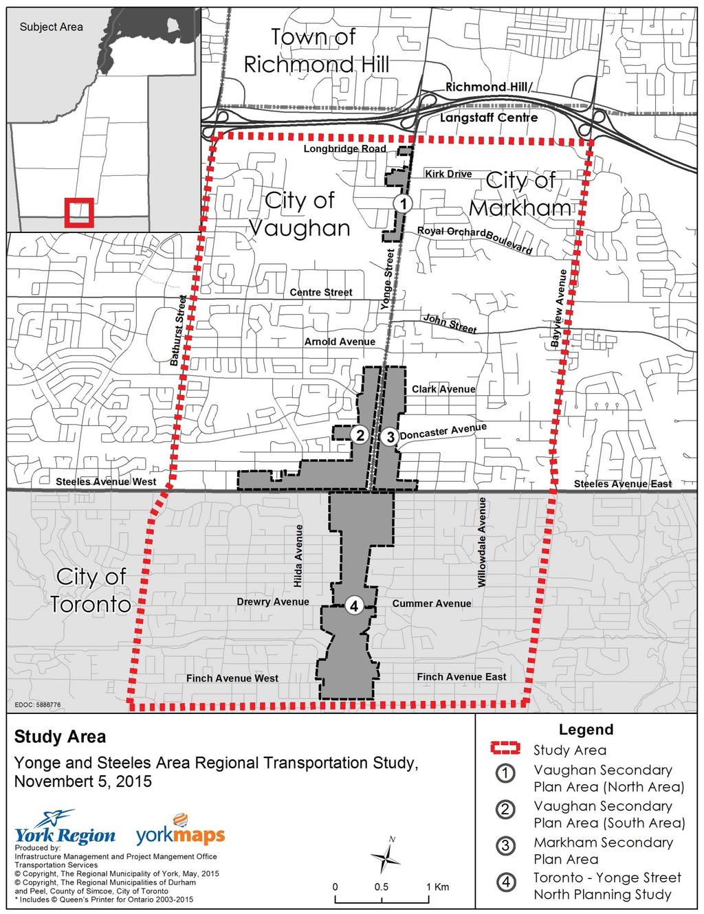
11 Attachment 1
12 IBI GROUP FINAL DRAFT REPORT YONGE AND STEELES AREA REGIONAL TRANSPORATION STUDY Submitted to York Region Attachment 2 Executive Summary The Yonge and Steeles Area is Unique and Requires a Strategic Approach The Yonge and Steeles Area is unlike any other in the Greater Toronto Area (GTA). The study area, as shown on Exhibit ES.1, encompasses three local municipalities in addition to the Region of York. Over the next 17 years, the area is expected to attract up to 39,000 additional residents and 11,600 additional jobs. These represent increases of 45% and 47% respectively. At the same time, aside from the Yonge Subway Extension and rapid transit on Steeles Avenue, there are limited opportunities to significantly expand transportation capacity. Looking across the boundary of Toronto with its surrounding Region s there is no other area which is similar in terms of growth and transportation challenges. Given the anticipated growth, each of the local municipalities has been conducting land use and transportation studies to help direct and manage new development. In total, there are eleven related studies that have been completed or are underway. The purpose of this study is to tie together the recommendations of on-going studies and to develop an overall plan to ensure that growth is accommodated in a predictable manner which does not overwhelm the transportation system. One of the key conclusions out of this study is that the road network is already failing today during the peak periods and there are few opportunities to increase arterial road capacity for automobiles. As a result, future development will need to be accommodated in a way that maximizes the potential for walking, cycling and transit modes. Even with this shift, residents and employees can expect continued congestion. Shaping the Approach The Yonge and Steeles Area Regional Transportation study was lead by the Region of York, in partnership with the cities of Vaughan, Markham and in coordination with the City of Toronto. A Technical Advisory Committee (TAC) consisting of representatives from the Region, the three local municipalities and Metrolinx was formed to guide the study. The TAC met a total of five times throughout the study, which provided an opportunity for sharing updates and recommendations from the various on-going studies. A critical early task in the study was to develop a clear picture of the land use forecasts for the study area. This included collecting forecasts by traffic zone from each of the three local municipalities and comparing these to the base Regional forecasts. Ultimately the forecast provided by each municipality were characterized as the High Growth Scenario for the purpose of the Regional study. All three municipalities confirmed these forecasts as being representative for modelling and transportation analysis purposes. It should be noted that this report has not gone through a public review process, and is meant to provide input and background for preparing future Official Plan Amendments, Secondary Plans, or in responding to major development proposals that would be subject to a full public review and planning process. Framing the Transportation Challenge The Yonge and Steeles Area is a key gateway between the Region of York and City of Toronto. Over half of the morning peak period trips destined to the study area is from the City of Toronto and about two-thirds of the trips from the study area in the morning peak are destined for Toronto. At present, the study area already has a fairly high transit mode share (22%) and almost 40% of the trips to, from and within the study area are made using sustainable modes (walking, cycling, transit or ride-sharing). MARCH

13 IBI GROUP FINAL DRAFT REPORT YONGE AND STEELES AREA REGIONAL TRANSPORATION STUDY Submitted to York Region Exhibit ES.1: Study Area and Previous/On-going Municipal Studies Few would argue that the existing network is near or not at capacity today. Key arterial to arterial intersections are operating at Level of Service E or F in the AM and PM peak periods. Similarly, buses travelling along Yonge Street experience high load factors and are delayed due MARCH
14 IBI GROUP FINAL DRAFT REPORT YONGE AND STEELES AREA REGIONAL TRANSPORATION STUDY Submitted to York Region to congestion and curb-side activities. Walking and cycling networks are also deficient in terms of comfort and connectivity. There are minimal on-street bicycle facilities and sidewalks on arterial roads located adjacent to high-volume traffic lanes. So what does the future look like in terms of transportation performance? Essentially, the network will become much more congested for automobiles. Based on the York Region transportation demand model, it is projected that AM peak hour auto driver trips from the study area will increase by 7,900 auto trips or 36% by 2031 under a high growth scenario. Even with more aggressive modal share targets in place, for example a 50% sustainable mode share, auto driver trips will still increase significantly. Accommodating any growth in automobile trips is only possible if traffic from outside of the study area is diverted or if drivers shift their travel times from the peak hours. The Yonge Subway Extension and Steeles Avenue Rapid Transit Are Essential The extension of the Line 1 (Yonge) Subway to Richmond Hill is a key priority for York Region and for the Yonge and Steeles Area. The Yonge Subway plays a very important role in providing increased transit capacity for local residents and employees. It will also help shape new development into more compact and walkable forms, just as it has done to the south in the City of Toronto. Similarly, the implementation of rapid transit on Steeles Avenue in a phased manner will further enhance transit capacity and is a key recommendation of this study. Success Will be Measured by the Performance of New Development Going by traditional transportation planning measurements, an argument could be made that very little new development in the study area can be accommodated. Specifically, when looking at the peak direction auto flows on Yonge Street and other arterials, the existing volumes are equal to the theoretical capacity of the roadway. However, it is not reasonable nor good planning policy to assume the area will remain stable in terms of growth (given prevailing land use policies and market conditions). Perhaps more importantly, the development and redevelopment of lands around the major transit spines is key to achieving a more walkable, bikeable and transit-friendly urban form. The Yonge and Steeles Area is not unlike many existing downtown areas in the GTA where development has taken place despite finite road capacity. Areas such as the Railway Lands in Downtown Toronto, Liberty Village, Yonge-Eglinton, North York and now Markham Centre and Vaughan Metropolitan Centre have all experienced rapid growth in the absence of major road capacity expansion, instead relying on capacity enhancements to other modes of transportation together with aggressive transportation demand management plans and measures. What this means, however, is that new development must go well-beyond typical minimum expectations for transit-supportive development. Developments must be measured on the basis of how much they reduce auto use compared to prevailing trends. If new developments can manage to achieve at least a 65% sustainable mode share (share of non-auto driver trips) then the overall sustainable share for the study area including stable development will be similar to Yonge-Eglinton (currently 50%). This is possible only if new developments minimize parking, contribute to localized pedestrian and cycling improvements and actively promote programs to reduce transportation demand and encourage transit use. In essence, the secondary plans and policies must aggressively plan for land uses and urban designs that promote higher live-work balance and reduced vehicular trip making and a much higher proportion of pedestrian and cycling trips (i.e. short trips). At the same time, new developments must be held to exceptional urban design standards which further contribute to improved all-season walking environments. This includes ensuring block sizes and building footprints in new development areas contribute to a finer grid network and permeability for walking trips. MARCH
15 IBI GROUP FINAL DRAFT REPORT YONGE AND STEELES AREA REGIONAL TRANSPORATION STUDY Submitted to York Region Measuring the performance of individual developments and monitoring area transportation performance is, in the context of the Yonge and Steeles Area, considered to be a more effective strategy than attempting to set development phasing thresholds based on transportation capacity alone. Development phasing solely based on transportation capacity would be extremely difficult to set and enforce as it would require setting limits on individual jurisdictions or individual parcels. Conversely, setting targets for individual development performance (e.g. mode shares, multi-modal infrastructure provision, mixed-use), in combination with annual monitoring, should provide municipalities with a greater influence over development, and a greater ability to achieve the type of development that is required to minimize transportation impacts. Development Phasing plans are required prior to Yonge Subway Extension As noted above, in a mature and high growth area such as the Yonge and Steeles Area, setting development level thresholds based on transportation network level of service measures is not practical. However, due to the significance of the extension of the Line 1 (Yonge Street) subway in impacting transportation capacity as well as the type and form of development, development phasing is recommended for the Yonge and Steeles Area. Setting development phasing for presubway development will ensure a necessary level of predictability for development and related transportation impacts. It is proposed that development phasing be set based on planning policies that provide for ongoing maturation and evolution of the area into the community that is envisioned in higher level planning documents such as Community and Official Plans. As well, such development phasing should be supported by examples of other more matured areas. In this case, the North York City Centre and Yonge-Eglinton area serve as good examples of more developed areas that could be emulated in the Yonge and Steeles Area. One of the challenges with relying on Official Plans for development phasing, is they do not specific population and employment totals by sub-area or traffic zone. However, given that growth in the Yonge and Steeles Area has been planned over many years through coordination between York Region, Markham, Vaughan and the City of Toronto consensus numbers were previously developed for detailed, technical analysis of land use and transportation related impacts. It is recommended that these consensus population and employment growth projections, as shown in Exhibit ES.2, be the development level thresholds for the Yonge and Steeles Area prior to construction of the Line 1 subway extension. Should the Line 1 subway and other rapid transit (Finch and Steeles) be delayed past 2021, this phasing would need to be revisited. It should be noted that the City of Toronto s Yonge Street North Planning Study (Draft as of May 2014) identifies a higher development phasing for the pre-subway condition than is shown in the table below. The higher figure has not yet been adopted and therefore remains preliminary; however, the City of Toronto did complete a transportation study as part of the Yonge Street North Planning Study. Since encouraging employment is a key strategy to manage transportation demand (i.e. through trip self-containment), it is recommended that no development phasing be placed on non-retail employment development for the York Region municipalities. MARCH
16 IBI GROUP FINAL DRAFT REPORT YONGE AND STEELES AREA REGIONAL TRANSPORATION STUDY Submitted to York Region Exhibit ES.2: Proposed Development Phasing (New Population) Net New Population Pre-Subway Post-Subway Total Vaughan 2,963 7,457 10,420 Markham 3,562 5,660 9,222 Sub-total York Region 6,525 13,117 19,642 Toronto - North of Cummer 4,780 9,375 14,155 Toronto - South of Cummer 2,560 4,755 7,315 Sub-total Toronto 7,340 14,130 21,470 Recommended Transportation Improvements Maximizing the transportation performance of new development is contingent on a number of transportation network enhancements. These enhancements are also critical to helping to maximize the use of walking, cycling and transit by existing residents and workers. Proposed transportation improvements for the study area are shown on Exhibit ES.3 and ES.4 and include the following major transportation improvements: Extension of Yonge Subway to Richmond Hill Centre, assumed to be under construction by 2021 Phased implementation of rapid transit on Steeles Avenue Interim: Widen the portion of Steeles between Bathurst Street and Hilda Avenue for curb bus-only lanes; convert existing curb lanes to bus-only lanes Hilda Avenue to Yonge Street; intersection transit priority east of Yonge Street (Note that these improvements are subject to design feasibility, Rightof-way constraints, and City of Toronto approval) With Subway: dedicated right-of-way from Hilda to Willowdale Avenue, replacing stops with stations Ultimate: dedicated right-of-way west of Willowdale Avenue Selected intersection improvements on Bayview Avenue and Bathurst Street to improve level of service for transit vehicles and possible widening for HOV lanes in the long term Extension of Dudley Avenue from Doncaster Avenue to Glen Cameron Road (subject to City of Markham Yonge-Steeles Corridor Transportation Study) MARCH

17 IBI GROUP FINAL DRAFT REPORT YONGE AND STEELES AREA REGIONAL TRANSPORATION STUDY Submitted to York Region Exhibit ES.3: Planned Road and Transit Improvements Exhibit ES.4: Planned Active Transportation Improvements MARCH
 Implementation of local road connections in City of Toronto (per Yonge Street North Planning Study) MARCH 17")
18 IBI GROUP FINAL DRAFT REPORT YONGE AND STEELES AREA REGIONAL TRANSPORATION STUDY Submitted to York Region Implementation of local road connections in Vaughan (per Yonge-Steeles Corridor Secondary Plan-South) Implementation of local road connections in City of Toronto (per Yonge Street North Planning Study) MARCH
19 IBI GROUP FINAL DRAFT REPORT YONGE AND STEELES AREA REGIONAL TRANSPORATION STUDY Submitted to York Region Also shown on Exhibit ES.4 are a number of planned cycling improvements which will help improve network connectivity and provide better connections to rapid transit spines. In addition to physical network enhancements, fare integration, service integration, station, streetscape and intersection design that promotes seamless connections between modes are also important in achieving sustainable mode share objectives. Taking Transportation Demand Management (TDM) to the next level It is clear from the transportation demand forecasts that aggressive measures will need to be put in place to encourage a shift away from car driving in favour of walking, cycling, transit and carpooling. In addition, trip avoidance or time-shifting will be inevitable given congestion levels. One of the observations from this study is that there are a number of different groups working on various aspects of TDM. The Region has been working with the development community to ensure funding, through development charges, and delivery of TDM service is place. Similarly, each local municipality is pursuing various TDM initiatives. Overlaying these efforts are those of Metrolinx and the two Smart Commute organizations that cover the study area (North Toronto- Vaughan and Markham-Richmond Hill), which generally focus on employer-based programs. Recognizing the need and existing efforts, the TDM strategy for the Yonge and Steeles Area focuses on the requirement for supportive features and conditions to be incorporated in new developments, as well as for outreach and services targeted at both existing and future developments. The strategy reflects several key principles including the following: Adopting best practices essentially aiming for the most aggressive measures similar to what the City of Toronto is already doing; Pursuing jurisdictional consistency which will help maximize the potential for update by the development community Providing the necessary resources, as well as avoiding duplication of efforts Building in required action through the normal course of business Being inclusive in order to ensure measures are provided for both new development and existing communities, as well as all types of developments. The Yonge and Steeles Area is unique enough that it may warrant a special designation to help align TDM initiatives and efforts. This could include a multi-jurisdictional coordination committee, a revisiting of the boundaries of the Smart Commute organizations to align better with the Yonge and Steeles Area, or a special brand which speaks to the need to transform travel behaviour in the study area. Policies to Realize Transportation Strategy The Region of York Official Plan together with local Official Plans and Secondary Plans provide the overall policy framework for the study area. However, there are several policies that need to be re-enforced in order to implement the transportation strategy identified in this report. As discussed in more detail in the main report, key policies that need to be strengthened and integrated into the development review process include the following: Retail, mixed-use and residential development will have a performance standard of non-sov modal share of at least 50% rising to 65% (to be determined through monitoring) when the Yonge subway extension is complete Encourage and prioritize employment uses to help improve the live-work balance for the area, with a goal of decreasing trips out of the area Implement consistent area specific parking rates through local jurisdictional parking by-laws. MARCH
20 IBI GROUP FINAL DRAFT REPORT YONGE AND STEELES AREA REGIONAL TRANSPORATION STUDY Submitted to York Region Require new development to identify and quantify necessary auto trip reduction strategies as part of development applications. Ensure that necessary pedestrian and cycling infrastructure (as outlined on ES.4 and in local area plans) is in place prior to development. Development may be asked to contribute funds to accelerate implementation of specific projects. Require all new development applications to include a statement of how they will contribute to the Healthy Development Index for the area (see below) In addition to development-related policies, there are a number of broader policies or actions that are required to help achieve the overall strategy: Identify opportunities for shared public parking, which can help to make parking for individual developments more efficient, and also enable a transition to reduced auto modal shares Continue to advocate for the Yonge Subway extension Implement transit signal priority upgrades on Yonge Street in the short term (specific locations are being identified through a separate process) Prepare and maintain an area specific tool for assessing the urban form of existing and proposed developments against standards that support active living and healthy communities. A template for the tool could be built off the model developed by the Region of Peel, referred to as a Healthy Development Index (HDI) Implementation Strategy The Yonge and Steeles Area Regional Transportation study is somewhat unique in that it requires many partners to implement the strategy. It is envisioned that the recommendations of this study will inform both future regional initiatives, such as the Region s Transportation Master Plan, as well as local studies and secondary plans. Some of the recommendations will need to be integrated into local practices and policies. In terms of infrastructure, most of the recommended improvements have are already identified in existing plans, but many require multi-jurisdictional cooperation. For example, any major improvements to Steeles Avenue will require extensive coordination between the City of Toronto and other jurisdictions. Exhibit ES.5 provides a summary of the planned/proposed infrastructure improvements along with the required timing, costs and lead agency. MARCH
21 IBI GROUP FINAL DRAFT REPORT YONGE AND STEELES AREA REGIONAL TRANSPORATION STUDY Submitted to York Region Exhibit ES.5: Recommended Infrastructure Improvements and Implementation Timelines Project Description Timing Cost ($M) Agencies Involved Transit Infrastructure Projects Under or Funded for Construction Bathurst Street (Highway 7 - Centre Street) Part of vivanext H2 Rapidway project Centre Street (Bathurst Street - Highway 7) Part of vivanext H2 Rapidway project $ YRRTC/York Region /Metrolinx 500 YRRTC/York Region /Metrolinx Planned Improvements TTC Line 1 Subway Extension (Finch - Richmond Hill Centre) Yonge Subway extension to Richmond Hill Centre is currently unfunded but is in Metrolinx's Next Wave of projects Before 2031 $ 3,400 TTC, YRRTC, Metrolinx Additional Recommended Improvements Steeles Avenue (Bathurst Street - Hilda Avenue) Widen 1-lane per direction for curbside bus lanes* $ 6.8 Toronto and York Region Steeles Avenue (Hilda Avenue - Yonge Street) Convert existing curb lanes to curbside bus lanes* $ 0.1 Toronto and York Region Steeles Avenue (Bathurst Street - Willowdale Avenue) Convert curbside bus lanes to median-running busway to connect to subway, does not include section as part of Steeles Station (part of Yonge Subway Extension budget)* Before 2031 $ 110 TTC and YRRTC Steeles Avenue Transit Intersection Priority - Transit pre-emption signal and queue-jump lane E of Yonge improvements at Willowdale, Maxom, Bayview* Before 2021 $ 0.9 Toronto and TTC Yonge Street Continuously monitor and improve transit priority measures (TSP, queue-jump lanes) at key intersections $ 10.0 York Region Sub-total Transit $ 4,028 Road widenings for traffic capacity and transit priority Planned Improvements Yonge Steeles Corridor Secondary Plan Fine grained street network of new collector and local roads Before 2031 $ 10.3 City of Vaughan Yonge Street North Secondary Plan Fine grained street network of new collector and local roads Before 2031 $ 38.5 City of Toronto Yonge Steeles Corridor Transportation Study Fine grained street network of new collector and local roads Before 2031 City of Markham Additional Recommended Improvements Finch subway station west commuter parking lot Construct new entrance from Talbot Road Before 2021 TTC Bayview Avenue (Highway 7 - Steeles Ave) Widening for HOV lanes plus rail grade separation (subject to feasibility study & EA) $ 43.8 York Region Bathurst Street (Centre Street - Steeles Avenue) Widening for HOV lanes plus rail grade separation (subject to feasibility study & EA) $ 16.1 York Region Dudley Ave Extension (Glen Cameron Road - 2-lane extension plus accommodations for walking Per Markham Doncaster Avenue) and cycling study $ 7.3 City of Markham Sub-total Roads $ 116 Active Transportation Planned Improvements Vaughan Pedestrian & Cycling Master Plan Complete all AT improvements as planned $ 0.6 Vaughan Markham Cycling Master Plan Complete all AT improvements as planned Per Markham study $ 1.3 Markham Toronto Bike Plan Complete all AT improvements as planned $ 1.0 Toronto York Region Pedestrian & Cycling Master Plan Complete all AT improvements as planned $ 0.5 York Region Additional Recommended Improvements Sidewalks On all streets within 400 m of a bus stop Vaughan, Markham, York Region, Toronto Sidewalks Add sidewalks to both sides of all arterial and collector roads in study area $ Vaughan, Markham, York 12.7 Region, Toronto Hilda Ave/Talbot Rd bike lanes Establish continuous bike lanes along Hilda Ave/Talbot Rd from Clark Ave to Finch Ave Before 2031 $ 0.5 Vaughan, Toronto Henderson Rd bike lanes Establish continuous bike lanes from John Street to Finch Ave Before 2031 $ 0.5 Markham, Toronto Dudley Ave/Willowdale Ave bike lanes Establish continuous bike lanes using Dudley Ave and Willowdale Ave from John St to Finch Ave Before 2031 $ 0.5 Markham, Toronto Yonge Street Cycle Track Completed following subway construction Before 2031 $ 5.9 York Region Sub-total Active Transportation $ 20.5 * Subject design feasibility and City of Toronto approval MARCH
22 IBI GROUP FINAL DRAFT REPORT YONGE AND STEELES AREA REGIONAL TRANSPORATION STUDY Submitted to York Region MARCH
Transportation Master Plan Advisory Task Force
 Transportation Master Plan Advisory Task Force Network Alternatives & Phasing Strategy February 2016 BACKGROUND Table of Contents BACKGROUND Purpose & Introduction 2 Linking the TMP to Key Council Approved
York Region Population and Employment Growth
 March 1, 2016 1 York Region Population and Employment Growth York Region needs to comply with The Provincial Growth Plan and new forecasts introduced to 2036 and 2041 2 Regional Official Plan Review York
WELCOME TO OPEN HOUSE # 1 June 14, 2017
 Langstaff Road Weston Road to Highway 7 Class Environmental Assessment Study WELCOME TO OPEN HOUSE # 1 June 14, 2017 Please sign in and join our mailing list Purpose of Open House #1 & Study Area York
4 Ridership Growth Study
 Clause 4 in Report No. 15 of Committee of the Whole was adopted, without amendment, by the Council of The Regional Municipality of York at its meeting held on November 16, 2017. 4 Ridership Growth Study
Transportation Assessment
 Transportation Assessment Midtown Open House February 10, 2018 Overview Midtown in Focus Overview & Purpose of Today Transportation Assessment overview Summary of Transportation work to date Review & Analysis
4 DISRUPTION MANAGEMENT PLAN HIGHWAY 7 RAPIDWAY CONSTRUCTION BETWEEN BAYVIEW AVENUE AND WARDEN AVENUE TOWNS OF MARKHAM AND RICHMOND HILL
 4 DISRUPTION MANAGEMENT PLAN HIGHWAY 7 RAPIDWAY CONSTRUCTION BETWEEN BAYVIEW AVENUE AND WARDEN AVENUE TOWNS OF MARKHAM AND RICHMOND HILL The Transportation Services Committee recommends the adoption of
Service Business Plan
 Service Business Plan Service Name Transportation Planning Service Type Public Service Owner Name Kaylan Edgcumbe Budget Year 2019 Service Owner Title Service Description Manager of Transportation Planning
CITY OF VAUGHAN EXTRACT FROM COUNCIL MEETING MINUTES OF OCTOBER 30, 2012
 CITY OF VAUGHAN EXTRACT FROM COUNCIL MEETING MINUTES OF OCTOBER 30, 2012 Item 31, Report No. 39, of the Committee of the Whole, which was adopted without amendment by the Council of the City of Vaughan
APPENDIX 2 LAKESHORE ROAD TRANSPORTATION REVIEW STUDY EXECUTIVE SUMMARY
 APPENDIX 2 LAKESHORE ROAD TRANSPORTATION REVIEW STUDY EXECUTIVE SUMMARY Appendix 2 City of Mississauga Lakeshore Road FINAL REPORT Transportation Review Study December 2010 EXECUTIVE SUMMARY Study Purpose
Appendix 1 Transit Network Analysis
 Appendix 1 Transit Network Analysis APPENDIX 1 TRANSIT NETWORK ANALYSIS The purpose of this appendix is to provide an update on the transit network analysis as it pertains to: i. SmartTrack ii. Scarborough
Welcome. Background. Goals. Vision
 Welcome The formal Public Information Centre (PIC) for the Transportation Master Plan How We GO will be held in early 2017. At that time we will present the recommended transportation system for Niagara
TRANSPORTATION TOMORROW SURVEY
 Clause No. 15 in Report No. 7 of was adopted, without amendment, by the Council of The Regional Municipality of York at its meeting held on April 17, 2014. 15 2011 TRANSPORTATION TOMORROW SURVEY recommends
Corporate. Report COUNCIL DATE: June 26, 2006 NO: C012 COUNCIL-IN-COMMITTEE. TO: Mayor & Council DATE: June 22, 2006
 Corporate NO: C012 Report COUNCIL DATE: June 26, 2006 COUNCIL-IN-COMMITTEE TO: Mayor & Council DATE: June 22, 2006 FROM: General Manager, Engineering FILE: 0410-20(MoT/Gate) SUBJECT: Surrey Response on
Chapter 7. Transportation. Transportation Road Network Plan Transit Cyclists Pedestrians Multi-Use and Equestrian Trails
 Chapter 7 Transportation Transportation Road Network Plan Transit Cyclists Pedestrians Multi-Use and Equestrian Trails 7.1 TRANSPORTATION BACKGROUND The District of Maple Ridge faces a number of unique
City of Hamilton s Transportation Master Plan (TMP) Public Consultation 3 December 2015
 Public Consultation 3 December 2015") City of Hamilton s Transportation Master Plan (TMP) Public Consultation 3 December 2015 McPhail Transportation Planning Services Ltd. AGENDA 6:00 7:00 pm Viewing Boards / Q & A with the Team 7:00 7:50
City of Hamilton s Transportation Master Plan (TMP) Public Consultation 3 December 2015 McPhail Transportation Planning Services Ltd. AGENDA 6:00 7:00 pm Viewing Boards / Q & A with the Team 7:00 7:50
Welcome. The Brooklin Secondary Plan and Transportation Master Plan are collectively referred to as the Brooklin Study.
 Welcome The Town of Whitby is undertaking a study to prepare a Secondary Plan and Transportation Master Plan to guide and manage growth in the Brooklin area. The Brooklin Secondary Plan and Transportation
Sixth Line Development - Transit Facilities Plan
 Memorandum Date: November 13, 2012 To: From: c.c. Subject: Rob Freeman (Freeman Planning) Kevin Phillips Sixth Line Development - Transit Facilities Plan 33016631 This memo was prepared to review the transit
Moving Cambridge. City of Cambridge Transportation Master Plan Public Consultation Centre. March 7, :00 8:00 PM.
 City of Cambridge Transportation Master Plan Public Consultation Centre March 7, 2018 5:00 8:00 PM Region of Waterloo City of Cambridge Transportation Master Plan Public Consultation Centre March 7, 2018
DON MILLS-EGLINTON Mobility Hub Profile
 Mobility Hub Profile Dundas Don Mills-Eglinton West-Bloor Anchor Hub Gateway Hub N MOBILITY HUBS: Places of connectivity between regional and rapid transit services, where different modes of transportation
Markham Sports, Entertainment and Cultural Centre Transportation Overview
 Markham Sports, Entertainment and Cultural Centre Transportation Overview ARENA LOCATION 2 3 TRANSPORTATION VISION IN MARKHAM On April 12, 2011, Markham Council adopted a long-term Transportation Vision
NEWMARKET CENTRE Mobility Hub Profile
 Mobility Hub Profile Dundas Newmarket West-Bloor Centre Anchor Hub Gateway Hub N MOBILITY HUBS: Places of connectivity between regional and rapid transit services, where different modes of transportation
WEST AND SOUTH WEST RING ROAD DOWNSTREAM TRAFFIC IMPACTS
 Page 1 of 9 EXECUTIVE SUMMARY Alberta Transportation ( AT ) is preparing to construct the final sections of the Calgary Ring Road. This includes the South West Ring Road ( SWRR ) (from Lott Creek Blvd
CITY OF COCOA BEACH 2025 COMPREHENSIVE PLAN. Section VIII Mobility Element Goals, Objectives, and Policies
 CITY OF COCOA BEACH 2025 COMPREHENSIVE PLAN Section VIII Mobility Element Goals, Objectives, and Policies Adopted August 6, 2015 by Ordinance No. 1591 VIII MOBILITY ELEMENT Table of Contents Page Number
PEDESTRIAN ACTION PLAN
 ATTACHMENT 2 CITY OF SANTA MONICA PEDESTRIAN ACTION PLAN CITY OF SANTA MONICA PEDESTRIAN ACTION PLAN This page intentionally left blank EXECUTIVE SUMMARY CHAPTER 1 EXECUTIVE SUMMARY Setting the Stage
APPENDIX B. TDM Existing Conditions
 APPENDIX B TDM Existing Conditions SCARBOROUGH CENTRE TMP TRANSPORTATION DEMAND MANAGEMENT INTRODUCTION Scarborough Centre has grown into a mixed-use hub for population, transportation, and employment
Climate Change Action Plan: Transportation Sector Discussion Paper: Cycling
 Climate Change Action Plan: Transportation Sector Discussion Paper: Cycling ontario.ca/climatechange Contents 1. Minister of Transportation s message... 3 2. Introduction... 5 3. Sector Overview and Support
Nomination. Halton Region in Context
 Transportation Association of Canada Sustainable Urban Transportation Award Nomination of: Region of Halton Regional Transportation Master Plan Study March 2005 Nominated by: Nomination The TAC Sustainable
Proposed. City of Grand Junction Complete Streets Policy. Exhibit 10
 Proposed City of Grand Junction Complete Streets Policy Exhibit 10 1 City of Grand Junction Complete Streets Policy Vision: The Complete Streets Vision is to develop a safe, efficient, and reliable travel
2 BOLTON COMMUTER RAIL SERVICE FEASIBILITY STUDY
 2 BOLTON COMMUTER RAIL SERVICE FEASIBILITY STUDY The Planning and Economic Development Committee recommends the adoption of the recommendations contained in the following report dated April 15, 2011 from
Welcome to the Open House
 Leslie Street Between 19 th Avenue and Stouffville Road Addendum to Class Environmental Assessment Study Welcome to the Open House Please sign in at the front desk. March 28, 2017 Richmond Green Sports
DON MILLS-SHEPPARD Mobility Hub Profile
 DON MILLS-SHEPPARD Mobility Hub Profile Dundas Don Mills-Sheppard West-Bloor Anchor Hub Gateway Hub N MOBILITY HUBS: Places of connectivity between regional and rapid transit services, where different
University of Victoria Campus Cycling Plan Terms of Reference. 1.0 Project Description
 University of Victoria Campus Cycling Plan Terms of Reference 1.0 Project Description The Campus Cycling Plan, a first for the University, will provide a comprehensive and coordinated approach to support
3 TRAFFIC CONTROL SIGNAL TIMING AND SYNCHRONIZATION
 Report No. 8 of the Transportation Services Committee Regional Council Meeting of October 20, 2011 3 TRAFFIC CONTROL SIGNAL TIMING AND SYNCHRONIZATION The Transportation Services Committee recommends:
The Regional Municipality of York. Transportation. Master Plan. November Transportation Master Plan
 The Regional Municipality of York Transportation Master Plan November 2016 2016 Transportation Master Plan A Message from York Region Chairman and CEO and Members of Regional Council The ability to travel
Public Consultation Centre
 Region of Waterloo Transportation Master Plan Update Public Consultation Centre See the Information Package on how to contact the Project Team and complete the Comment Sheet www.regionofwaterloo.ca/en/exploring-the-region/transportation-master-plan.aspx
CITY OF BLOOMINGTON COMPLETE STREETS POLICY
 CITY OF BLOOMINGTON COMPLETE STREETS POLICY POLICY OBJECTIVE: The City of Bloomington will enhance safety, mobility, accessibility and convenience for transportation network users of all ages and abilities,
Exhibit 1 PLANNING COMMISSION AGENDA ITEM
 Exhibit 1 PLANNING COMMISSION AGENDA ITEM Project Name: Grand Junction Circulation Plan Grand Junction Complete Streets Policy Applicant: City of Grand Junction Representative: David Thornton Address:
TRANSPORTATION NEEDS ASSESSMENT
 TRANSPORTATION NEEDS ASSESSMENT A travel demand analysis was carried out to determine the operational issues and the potential benefit that adding traffic capacity would have on the road network. All the
ACTIVE TRANSPORTATION/NONMOTORIZED TRANSPORTATION
 ACTIVE TRANSPORTATION/NONMOTORIZED TRANSPORTATION BACKGROUND Active transportation, also known as nonmotorized transportation, is increasingly recognized as an important consideration when planning and
5. Pedestrian System. Accomplishments Over the Past Five Years
 5. Pedestrian System Accomplishments Over the Past Five Years The Alamo Area Metropolitan Planning Organization (MPO) and its partner agencies recognize the importance of improving pedestrian mobility.
Prepared For: Shieldbay Developments Inc. c/o Matson, McConnell Ltd. 2430A Bloor Street West Toronto, Ontario M6S 1P9.
 Prepared For: Shieldbay Developments Inc. c/o Matson, McConnell Ltd. 2430A Bloor Street West Toronto, Ontario M6S 1P9 Prepared By: URS Canada Inc. 4 th Floor, 30 Leek Crescent Richmond Hill, Ontario L4B
Bus Rapid Transit Plans
 Twin Cities Region Bus Rapid Transit Plans ULI Minnesota Workshop Connecting Bus Rapid Transit to the Community December 15, 2009 John Levin Director of Service Development Metro Transit Metropolitan Area
Develop a Multi-Modal Transportation Strategy (Theme 6)
") DEVELOP A MULTI-MODAL TRANSPORTATION STRATEGY (THEME 6) WHY IS THIS THEME ADDRESSED? Develop a Multi-Modal Transportation Strategy (Theme 6) Statement of Ideal Reduce resident and visitor reliance on single
DEVELOP A MULTI-MODAL TRANSPORTATION STRATEGY (THEME 6) WHY IS THIS THEME ADDRESSED? Develop a Multi-Modal Transportation Strategy (Theme 6) Statement of Ideal Reduce resident and visitor reliance on single
Solana Beach Comprehensive Active Transportation Strategy (CATS)
") Solana Beach Comprehensive Active Transportation Strategy (CATS) 3.0 Goals & Policies The Solana Beach CATS goals and objectives outlined below were largely drawn from the Solana Beach Circulation Element
Solana Beach Comprehensive Active Transportation Strategy (CATS) 3.0 Goals & Policies The Solana Beach CATS goals and objectives outlined below were largely drawn from the Solana Beach Circulation Element
NORTH YORK CENTRE Mobility Hub Profile
 Mobility Hub Profile Dundas North York West-Bloor Centre Anchor Hub Gateway Hub N MOBILITY HUBS: Places of connectivity between regional and rapid transit services, where different modes of transportation
Transportation Master Plan Advisory Task Force
 Transportation Master Plan Advisory Task Force Draft Network Alternatives January 2016 INTRODUCTION Table of Contents Purpose 2 Linking major initiatives to key council approved plans 2 Disclaimer for
ATTACHMENT 4 - TDM Checklist. TDM Checklist Overview
 ATTACHMENT 4 - TDM Checklist TDM Checklist Overview The proposed checklist rates developments on the degree to which they are TDM and transit supportive. Points are assigned based on the level of transit
4. ENVIRONMENTAL IMPACT ANALYSIS 9. TRANSPORTATION AND TRAFFIC
 4. ENVIRONMENTAL IMPACT ANALYSIS 9. TRANSPORTATION AND TRAFFIC 4.9.1 INTRODUCTION The following section addresses the Proposed Project s impact on transportation and traffic based on the Traffic Study
Chapter 4 Transportation Strategies to Support Growth
 City of Brantford Chapter 4 Transportation Strategies to Support Growth TABLE OF CONTENTS 4.1 DESIGNING A TRANSPORTATION STRATEGY... 1 4.2 STRATEGIES TO INCREASE SUPPLY... 2 4.2.1 Optimizing the Existing
DUNDAS WEST-BLOOR Mobility Hub Profile
 Mobility Hub Profile Dundas West-Bloor Anchor Hub Gateway Hub N MOBILITY HUBS: Places of connectivity between regional and rapid transit services, where different modes of transportation come together
In station areas, new pedestrian links can increase network connectivity and provide direct access to stations.
 The Last Mile Planning for Pedestrians Planning around stations will put pedestrians first. Making walking to stations safe and easy is important; walking will be a part of every rapid transit Accessible
WELCOME. City of Greater Sudbury. Transportation Demand Management Plan
 WELCOME City of Greater Sudbury Transportation Demand Management Plan Public Consultation Session St. Andrew s Place, Activity Hall 111 Larch Street Wednesday September 13, 2017 6:00 to 8:00 pm Welcome
Chapter 5 Future Transportation
 Chapter 5 Future Transportation The Future Land Use Plan identifies the desired land use designations. The land uses desired for Crozet depend, in large part, on the success of the transportation system,
CONNECTING PEOPLE TO PLACES
 CONNECTING PEOPLE TO PLACES 82 EAST BENCH MASTER PLAN 07 Introduction The East Bench transportation system is a collection of slow moving, treelined residential streets and major arteries that are the
Capital and Strategic Planning Committee. Item III - B. April 12, WMATA s Transit-Oriented Development Objectives
 Capital and Strategic Planning Committee Item III - B April 12, 2018 WMATA s Transit-Oriented Development Objectives Page 24 of 76 Washington Metropolitan Area Transit Authority Board Action/Information
Executive Summary... iv
 TOWNOFHALTONHI LLS TRANSPORTATI ON MASTERPLAN REPORT Nove mbe r201 1 i na s s o c i a t i o nwi t h HALTON HILLS TRANSPORTATION MASTER PLAN i Executive Summary... iv 1. Introduction... 1 1.1 Study Purpose...1
Durham Region Long Term Transit Strategy
 Durham Region Long Term Transit Strategy An adaptive, safe, reliable, frequent, accessible and desirable transit system that shapes and connects Durham Region and beyond in an economically and environmentally
WELCOME! To the Centennial Neighbourhoods Secondary Plan and Transportation Management Plan Information Centre. City of Hamilton
 WELCOME! To the Centennial Neighbourhoods Secondary Plan and Transportation Management Plan Information Centre City of Hamilton Public Information Centre #2 Dec 1, 2015 CENTENNIAL NEIGHBOURHOODS SECONDARY
EXECUTIVE SUMMARY OF CALEDON TRANSPORTATION NEEDS STUDY
 EXECUTIVE SUMMARY OF CALEDON TRANSPORTATION NEEDS STUDY The Caledon Transportation Needs Study has been undertaken as a joint project by the Town of Caledon and the Region of Peel to determine the existing
2.2 TRANSIT VISION 2040 FROM VISION TO ACTION. Emphasize transit priority solutions STRATEGIC DIRECTION
 TRANSIT VISION 2040 FROM VISION TO ACTION TRANSIT VISION 2040 defines a future in which public transit maximizes its contribution to quality of life with benefits that support a vibrant and equitable society,
TRANSPORTATION STUDY REPORT DRAFT - APRIL 2015 A BLUEPRINT FOR HOW WE CAN GET AROUND GREATER SUDBURY, FROM NOW UNTIL 2031
 TRANSPORTATION STUDY REPORT DRAFT - APRIL 2015 A BLUEPRINT FOR HOW WE CAN GET AROUND GREATER SUDBURY, FROM NOW UNTIL 2031 A summary of what s there, what more is needed, how to find information about your
WHITE PAPER: TRANSIT SERVICE FOR SOUTH SHAGANAPPI
 9/27/2012 TRANSIT PLANNING WHITE PAPER: TRANSIT SERVICE FOR SOUTH SHAGANAPPI 2012 Calgary Transit 1 Table of Contents Purpose... 3 Area of Change... 3 Background... 3 Access to destinations... 5 Connecting
CHAPTER 7.0 IMPLEMENTATION
 CHAPTER 7.0 IMPLEMENTATION Achieving the vision of the Better Streets Plan will rely on the ability to effectively fund, build and maintain improvements, and to sustain improvements over time. CHAPTER
Appendix J Transportation Master Plan Assessment
 Appendix J 2002 Transportation Master Plan Assessment York Region Transportation Master Plan October 2009 ASSESSMENT OF 2002 YORK REGION TMP ACTION PLAN A Background Report By Cansult Limited December
Roadways. Roadways III.
 Introduction 97 Roadway Design Principles 98 Safe Speeds 99 Optimizing of Street Space 00 Minimum Lane Widths in the City of Boston 02 Design Features that Reduce Operating Speeds 05 Travel Lanes Transit
3 FRAMEWORK FOR IMPLEMENTATION OF LAKE-TO-LAKE CYCLING ROUTE
 3 FRAMEWORK FOR IMPLEMENTATION OF LAKE-TO-LAKE CYCLING ROUTE The Planning and Economic Development Committee recommends the adoption of the recommendations contained in the following report dated December
Appendix A-K Public Information Centre 2 Materials
 Appendix A-K Public Information Centre 2 Materials Our Rapid Transit Initiative Make an impact on the future of transit Join the discussion on Rapid Transit in London You re invited to a Public Information
AIRPORT ROAD ENVIRONMENTAL ASSESSMENT
 WELCOME TO PUBLIC INFORMATION CENTRE #1 AIRPORT ROAD ENVIRONMENTAL ASSESSMENT From Braydon Boulevard/Stonecrest Drive to Countryside Drive November 23, 2017 6:30 PM 8:30 PM Please sign in and fill out
Classification Criteria
 SCHEDULE D TO RECOMMENDED OFFICIAL PLAN AMENDMENT NO. 40 SCHEDULE C-4 Road Criteria Criteria Traffic Service Objective Land Service/Access Typical Daily Traffic Volume Flow characteristics Travel Speed
Harbord Street and Hoskin Avenue Bicycle Lane Upgrades
 STAFF REPORT ACTION REQUIRED and Bicycle Lane Upgrades Date: April 22, 2014 To: From: Wards: Reference Number: Public Works and Infrastructure Committee General Manager, Transportation Services 19 and
City of Novi Non-Motorized Master Plan 2011 Executive Summary
 City of Novi Non-Motorized Master Plan 2011 Executive Summary Prepared by: February 28, 2011 Why Plan? Encouraging healthy, active lifestyles through pathway and sidewalk connectivity has been a focus
T1-A - Service Reduction (Re-sizing)
") Key T1-A Choice A Key T1-B Choice B Key T1-C Choice C Key T1-D Choice D Key T1-E Choice E Key T1-F Choice F Key Choice G T2 T1-A - Service Reduction (Re-sizing) Description This key choice would represent
Key T1-A Choice A Key T1-B Choice B Key T1-C Choice C Key T1-D Choice D Key T1-E Choice E Key T1-F Choice F Key Choice G T2 T1-A - Service Reduction (Re-sizing) Description This key choice would represent
June 2015 REGIONAL TRANSPORTATION SNAPSHOT
 June 2015 REGIONAL TRANSPORTATION SNAPSHOT THE REGION Who are we? The Greater Toronto and Hamilton Area (GTHA), consisting of Durham Region, Halton Region, the City of Hamilton, Peel Region, the City of
Kitchener Integrated Transportation Master Plan
 Final Report Kitchener Integrated Transportation Master Plan TRANSPORTATION S ROLE IN A COMPLETE AND HEALTHY KITCHENER June 2013 Table of Contents Executive Summary: Implementation Measures... 1 1. Travel
2. Context. Existing framework. The context. The challenge. Transport Strategy
 Transport Strategy Providing quality connections Contents 1. Introduction 2. Context 3. Long-term direction 4. Three-year priorities 5. Strategy tree Wellington City Council July 2006 1. Introduction Wellington
ROUTES 55 / 42 / 676 BUS RAPID TRANSIT LOCALLY PREFERRED ALTERNATIVE
 ROUTES 55 / 42 / 676 BUS RAPID TRANSIT LOCALLY PREFERRED ALTERNATIVE April, 2012 1 INTRODUCTION The need for transit service improvements in the Routes 42/55/676 corridor was identified during the Southern
Bicycle Master Plan Goals, Strategies, and Policies
 Bicycle Master Plan Goals, Strategies, and Policies Mobilizing 5 This chapter outlines the overarching goals, action statements, and action items Long Beach will take in order to achieve its vision of
Road Alterations - Wellington Street East, Church Street, and Front Street Intersection
 REPORT FOR ACTION Road Alterations - Wellington Street, Church Street, and Front Street Intersection Date: November 1, 2016 To: Toronto and York Community Council From: Director, Public Realm Section,
Corpus Christi Metropolitan Transportation Plan Fiscal Year Introduction:
 Introduction: The Safe, Accountable, Flexible, Efficient Transportation Equity Act: A Legacy for Users (SAFETEA-LU) has continued the efforts started through the Intermodal Surface Transportation Efficiency
Regional Transportation Needs Within Southeastern Wisconsin
 Regional Transportation Needs Within Southeastern Wisconsin #118274 May 24, 2006 1 Introduction The Southeastern Wisconsin Regional Planning Commission (SEWRPC) is the official areawide planning agency
Arterial Transitway Corridors Study. Ave
 Arterial Transitway Corridors Study Ave January 2012 Arterial Transitway Corridors Study Overview Corridor Features and Demographics 11 study corridors, 95 route miles 86,000 daily rides and half of existing
Executive Summary Route 30 Corridor Master Plan
 Route Corridor Master Plan Project Overview The Route Corridor Master Plan is a coordinated multimodal transportation and land use plan for the entire stretch of Route through East Whiteland Township,
Public Event 1 Community Workshops
 Public Event 1 Community Workshops Nov. 24 & Dec. 3, 2016 Welcome Workshop Purpose We re looking to you for ideas and insights to help guide future transportation infrastructure planning in the Park Lawn
Town of Oakville Growth Areas Transportation Report
 Growth Areas Transportation Report Oakville itrans Consulting Inc. 100 York Blvd., Suite 300 Richmond Hill, ON L4B 1J8 Tel: (905) 882-4100 Fax: (905) 882-1557 www.itransconsulting.com Growth Areas Transportation
PG29.6 REPORT FOR ACTION. Downtown Mobility Strategy SUMMARY
 PG29.6 REPORT FOR ACTION Downtown Mobility Strategy Date: April 17, 2018 To: Planning and Growth Management Committee From: Chief Planner and Executive Director, City Planning and General Manager, Transportation
Standing Committee on Policy and Strategic Priorities
 POLICY REPORT Report Date: January 15, 2019 Contact: Steve Brown Contact No.: 604.873.9733 RTS No.: 12955 VanRIMS No.: 08-2000-20 Meeting Date: January 30, 2019 TO: FROM: SUBJECT: Standing Committee on
Basalt Creek Transportation Refinement Plan Recommendations
 Basalt Creek Transportation Refinement Plan Recommendations Introduction The Basalt Creek transportation planning effort analyzed future transportation conditions and evaluated alternative strategies for
Rochester Area Bike Sharing Program Study
 roc bike share Rochester Area Bike Sharing Program Study Executive Summary ~ January 2015 JANUARY 2015 8484 Georgia Avenue, Suite 800 Silver Spring, MD 20910 3495 Winton Pl., Bldg E, Suite 110 Rochester,
Main-McVay Transit Study: Phase 2 Options Definition and High Level Constraints Evaluation
 Main-McVay Transit Study: Phase 2 Options Definition and High Level Constraints Evaluation APRIL 2016 A collaborative study between: For Additional Information or to Comment If you would like additional
Public Works and Infrastructure Committee. General Manager, Transportation Services. P:\2016\Cluster B\TRA\TIM\pw16009tim.docx
 Ten Year Cycling Network Plan Date: May 3, 2016 STAFF REPORT ACTION REQUIRED PW13.11 To: From: Wards: Reference Number: Public Works and Infrastructure Committee General Manager, Transportation Services
Preliminary Transportation Analysis
 Preliminary Transportation Analysis Goals of a Robust, Multimodal Transportation Network Safe Accessible/Connected Efficient Comfortable Context-Sensitive Motor Vehicle: Continue to analyze the data to
Public Consultation Centre For. Transportation Master Plan Update. Information Package
 Public Consultation Centre For Transportation Master Plan Update Information Package Date Location Hours Tuesday, September 12, 2017 Wednesday, September 13, 2017 Tuesday, September 19, 2017 Cambridge
Purpose and Need. Chapter Introduction. 2.2 Project Purpose and Need Project Purpose Project Need
 Chapter 2 Purpose and Need 2.1 Introduction The El Camino Real Bus Rapid Transit (BRT) Project (Project) would make transit and other transportation improvements along a 17.6-mile segment of the El Camino
TRANSIT & NON-MOTORIZED PLAN DRAFT FINAL REPORT Butte County Association of Governments
 1 INTRODUCTION Maintaining a high quality of life is the essence of this plan for transit and non-motorized transportation in Butte County. Curbing greenhouse gas emissions (GHG) by reducing congestion,
SANTA MONICA BOULEVARD CORRIDOR
 CIRCULATION ELEMENT WHITE PAPER NO. 3 SANTA MONICA BOULEVARD CORRIDOR INTRODUCTION From the 1930s to the beginning of Los Angeles freeway era, Santa Monica Boulevard, (previously Route 66, the Beverly
Sustainable Transportation Initiatives and Plans in Caledon
 Sustainable Transportation Initiatives and Plans in Caledon Arash Olia, P.Eng., PhD. Coordinator, Transportation Development Finance & Infrastructure Services Town of Caledon Eric Chan, P.Eng., PMP Manager,
Douglas Land Use and Transportation Strategy (DLUTS) Summary. August 2013
 Summary. August 2013") Douglas Land Use and Transportation Strategy (DLUTS) Summary August 2013 Background Douglas is a large and popular residential suburb of approximately 30,000 persons on the periphery of Cork City along
Douglas Land Use and Transportation Strategy (DLUTS) Summary August 2013 Background Douglas is a large and popular residential suburb of approximately 30,000 persons on the periphery of Cork City along
A NEW PATH TRANSPORTATION MASTER PLAN
 A NEW PATH TRANSPORTATION MASTER PLAN November 2012 Table of Contents 1. Introduction... 1-1 1.1 Historical Patterns of Growth... 1-1 1.2 Planning Background and Regional Context... 1-2 1.3 Study Purpose...
Chapter 2. Bellingham Bicycle Master Plan Chapter 2: Policies and Actions
 Chapter 2 Bellingham Bicycle Master Plan Chapter 2: Policies and Actions Chapter 2: Policies and Actions The Bicycle Master Plan provides a road map for making bicycling in Bellingham a viable transportation
County of Simcoe Transportation Master Plan
 FINAL REPORT County of Simcoe July 2008 PREPARED FOR: County of Simcoe County Administration Centre 1110 Highway #26 Midhurst, ON L0L 1X0 PREPARED BY: Earth Tech Canada Inc. 105 Commerce Valley Drive West