MISSISSIPPI EAST BANK TRAIL
|
|
|
- Alexandra Campbell
- 6 years ago
- Views:
Transcription


1 MINNEAPOLIS PARK AND RECREATION BOARD MISSISSIPPI EAST BANK TRAIL PUBLIC MEETING #

2 What We ve Heard: Feedback from Public Meeting #2 Items that are very important to the community: Trail lighting Wayfinding signage Stormwater management Where possible, separate bikes from pedestrians Install two rest stops/overlooks Install a bike Fixit station If safe, no fencing between river and trail Keep bikes out of memorial site Maintain sufficient open space in Sheridan Memorial Park Create local trail spur to connect to the neighborhood 2


3 Trail Design/Cross-Sections MPRB trail standards include separated treadways, where feasible MPRB trails serve both recreational and commuter bicyclists COMBINED TRAIL USES SEPARATED TRAIL USES +/- 8 wide boulevard 12 wide min. combined bike/pedestrian trail +/- 8 wide boulevard 10 wide bike trail +/- 8 wide boulevard 8 wide pedestrian path 3


4 Existing Conditions South of Broadway Street NE Trail in Boom Island Park View under Plymouth Ave. Bridge Scherer Park site looking toward Plymouth Ave. Scherer Park site looking toward Ramsey St. Berm on Graco property looking north Graco property view looking north Graco property view looking south View under Broadway Ave. Bridge looking north View under Broadway Ave. Bridge looking south 4
 Mississippi")
5 Proposed Scherer Park Trail Alignment Legend: Combined Use Trail On-Street Bike Lane 8 Pedestrian Trail Bike Network Pedestrian Access Shared Lane Scherer Park Trail (future) Mississippi River Trail 5
 On-Street")
6 Recommended Trail Alignment South of Broadway St. Legend: Combined Use Trail 8 Pedestrian Trail Pedestrian Access Scherer Park Trail (future) On-Street Bike Lane Bike Network Shared Lane Mississippi River Trail 6


7 Proposed Trail Location Under Plymouth Ave. Bridge Bridge beam 4% slope New wall Bridge abutment Existing Ground Line 48 Fence Trail 50- year flood High water level Mean water level Proposed channel (by others) Bridge pile 7

8 Proposed Trail Location at Graco Site (Typical) Fence 5 Minimum to bluff 12 wide combined bike/pedestrian trail 2 5 +/-17 Graco fi re lane 8


9 Existing Conditions North of Broadway Street NE View looking north in Sheridan Memorial Park View looking north from the memorial site View looking south in Sheridan Memorial Park View looking south toward the memorial View looking north in Sheridan Memorial Park View looking north toward BNSF tracks View looking south adjacent to abandoned tracks View looking east toward Marshall St. View looking south along abandoned tracks 9
 On-Street")
10 Recommended Trail Alignment North of Broadway St. Legend: Combined Use Trail 8 Pedestrian Trail Pedestrian Access Scherer Park Trail (future) On-Street Bike Lane Bike Network Shared Lane Mississippi River Trail 10
11 Recommended Trail Alignment North of Broadway St. Legend: Combined Use Trail 8 Pedestrian Trail Pedestrian Access Scherer Park Trail (future) On-Street Bike Lane Bike Network Shared Lane Mississippi River Trail 11


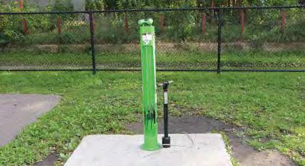
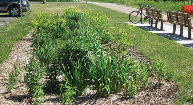
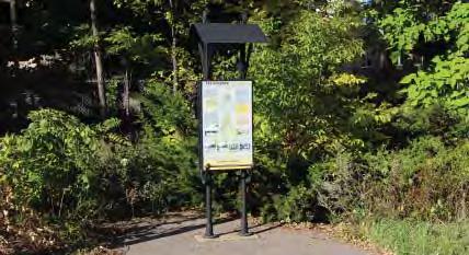
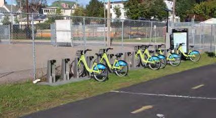
12 Potential Trail Amenities Trail Lighting Bike Fixit Station Stormwater Management Rest Stop Wayfinding Signage Interpretive Signage Kiosk Picnic Area Nice Ride Bike Share Station 12
13 Community Advisory Committee Recommendation The non-appointed Community Advisory Committee for the Mississippi East Bank Trail project recommends that the MPRB Board of Commissioners accepts its recommendation to approve the Concept Plan for the as shown in the attached graphics and as described below: Follow federal standards for bicycle and pedestrian trail design. Provide continuous bicycle and pedestrian trails from Boom Island and 8th Avenue NE (Plymouth Avenue) to Marshall Street NE at the BNSF Bridge. Provide separated bicycle and pedestrian trails wherever possible. Provide a combined-use trail of adequate width to accommodate bicycles and pedestrians where separated trails are not possible. Provide lighting along the trail because it is in a secluded area. Add wayfinding/directional signage throughout the project area. Provide two rest areas and a bicycle fix-it station. Provide stormwater management along the corridor. The non-appointed Community Advisory Committee recognizes that there are segments of the trail that will require further research and discussion and authorizes the consultant, SRF Consulting Group, and the MPRB to resolve these issues, according to the priorities listed above. 13

14 Next Steps Review outcomes from public meeting with MPRB staff Public hearing on November 19th Board of Commissioners meeting on December 3rd Trail design through winter 2014/15 Bidding late 2015 Trail construction through
15 MINNEAPOLIS PARK AND RECREATION BOARD MISSISSIPPI EAST BANK TRAIL PUBLIC MEETING #
Lee s Summit Road Improvement Study Public Open House June 7, 2007 Summary of Comment Card Responses
 Lee s Summit Road Improvement Study Public Open House June 7, 2007 Summary of Comment Card Responses Introduction At the Lee s Summit Road Improvement Study Public Open House held Thursday, June 7, 2007
Active Transportation Rail to River Corridor. Community Meeting - Segment A
 Active Transportation Rail to River Corridor Community Meeting - Segment A June 29, 2017 Tonight s Agenda > Open House (30 min) > Welcome / Project Overview > Presentation of 30% Design Refinements > Next
TRANSPORTATION COMMISSION Agenda Staff Report
 TRANSPORTATION COMMISSION Agenda Staff Report Agenda Item No. 5.a DATE: JULY 31, 2014 TO: FROM: SUBJECT: TRANSPORTATION COMMISSION COMMUNITY DEVELOPMENT DEPARTMENT - PLANNING DRAFT OLYMPIC CORRIDOR PREFERRED
MASTER BICYCLE AND PEDESTRIAN PLAN
 VILLAGE OF NORTHBROOK MASTER BICYCLE AND PEDESTRIAN PLAN DRAFT PLAN OPEN HOUSE May 2, 2018 AGENDA 1. Community Engagement 2. Vision and Goals 3. General Structure of Plan 4. Recommendations Overview 5.
42nd Ave N Reconstruction
 CITY OF MINNEAPOLIS 42nd Ave N Reconstruction Community Meeting #2 May 2016 6:00 7:30 p.m. 5/16/2016 1 Purpose of Meeting Inform: Provide an overview of project, identify anticipated scope of work, and
Major Bike Routes 102 Avenue Workshop April 21, 2015
 Major Bike Routes 102 Avenue Workshop April 21, 2015 Our Purpose Today Provide context on how Major Bike Routes fit into Edmonton s future Share information on what we heard in our last phase, and how
Chapter 7 Nonmotorized Facilities
 Chapter 7 Nonmotorized Facilities What is in this chapter? This chapter discusses existing and proposed pedestrian and bicycle facilities referred to as nonmotorized facilities along the SR 520 corridor.
Lake to Lake LAKE YORK. CYCLING ROUTE and WALKING TRAIL FEASIBILITY and DESIGN STUDY LAKE. CITY of REGION ONTARIO SIMCOE TORONTO
 LAKE SIMCOE Lake to Lake CYCLING ROUTE and WALKING TRAIL FEASIBILITY and DESIGN STUDY YORK REGION Overview Report JUNE 2013 CITY of TORONTO LAKE ONTARIO Table of Contents Study background 2 Study Background............................
» Draft Recommendations» Discussion» Next Steps. Plan for Walking and Biking
 SAC Meeting Plan #3 for September Walking and 12, Biking 2018 » Draft Recommendations» Discussion» Next Steps Plan for Walking and Biking » Stakeholder and Public Outreach» Background data collection and
What Is a Complete Street?
 Session 5 Charleen Zimmer, AICP, Zan Associates May 5-7, 2010 What Is a Complete Street? May 2010 5-1 Not a Complete Street More of a Complete Street May 2010 5-2 Benefits of Complete Streets Safety for
Saskatchewan Drive Roadway Rehabilitation and Shared-Use Path Widening
 Saskatchewan Drive Roadway Rehabilitation and Shared-Use Path Widening We are here today to present the draft plan for the Saskatchewan Drive Roadway Rehabilitation and Shared-Use Path Widening project
LANCASTER CITY BICYCLE NETWORK
 LANCASTER CITY BICYCLE NETWORK Downtown Merchants Meeting Wednesday, July 19, 2017 http://www.lancasteratp. DOWNTOWN WALKABILITY ANALYSIS What changes can be made, in the least amount of time, and for
Blue Ribbon Commission Report Recommendations on Pedestrian and Bicycle Infrastructure Improvements
 Recommendations on Pedestrian and Bicycle Infrastructure Improvements July 2017 Plan Development: Our committee consisted of seven individuals appointed by the Mayor and Village Board. Those members included:
section 4 Existing Conditions, Issues, and Options
 section 4 Existing Conditions, Issues, and Options 4.0 Existing Conditions, Issues, and Options This section analyzes each segment of the corridor on a street to street basis. Each segment is discussed
Bicycle Pedestrian Master Plan Pre Bid Meeting Portsmouth, NH August 15, 2013
 Bicycle Pedestrian Master Plan Pre Bid Meeting Portsmouth, NH August 15, 2013 2005 Master Plan GOAL: Provide for safe and convenient bicycle and pedestrian circulation throughout the City. Develop a city
Safe Streets. City of Lake Forest Park. March 21, 2017
 Safe Streets City of Lake Forest Park March 21, 2017 1 01 WELCOME 2 Agenda WELCOME WHAT IS THIS PROJECT? CONTEXT DRAFT CITYWIDE PROJECTS EXERCISE INTRODUCTION 3 02 WHAT IS THIS PROJECT? 4 WHAT IS THIS
9/25/2018. Multi-Modal Level of Service (MMLOS) Bianca Popescu, Transportation Planner
 Bianca Popescu, Transportation Planner") Multi-Modal Level of Service (MMLOS) Bianca Popescu, Transportation Planner 1 What is MMLOS? Is this a nice place to walk? Is this a nice place to bike? Is transit convenient? Bottom line - Are there options
Multi-Modal Level of Service (MMLOS) Bianca Popescu, Transportation Planner 1 What is MMLOS? Is this a nice place to walk? Is this a nice place to bike? Is transit convenient? Bottom line - Are there options
Hennepin County Bicycle and Pedestrian Planning
 Hennepin County Bicycle and Pedestrian Planning 1 Value of bicycle and sidewalk systems Safety Livability Mobility Health Personal Finances Economic Sustainability Clean Air Recreation Parking and congestion
Proposed Bridge Street East Bicycle Lanes Public Open House Thursday, April 27, 2017
 WELCOME Proposed Bridge Street East Bicycle Lanes Public Open House Thursday, April 27, 2017 Purpose of the Open House The purpose of this Open House is to gain public input on the bicycle lanes proposed
Parks, Open Space, Trails and Recreation Master Plan
 5.3 DEFINITIONS AND VOCABULARY In order to fully understand the range of trails that have been developed, and should be developed, throughout the community, a vocabulary needs to be established for the
Section 5: Bike and Pedestrian
 Section 5: Bike and Pedestrian Existing Conditions: One defining feature of Glynn County appreciated by both residents and visitors is the extensive sidewalk and bike path system. The City of Brunswick,
Make Lincoln Highway an economically vibrant corridor that is safe, efficient, and beautiful for local residents and visitors.
 Lincoln Highway Streetscape Plan Stakeholder Workshop #2 Handout Contents Introduction and Project Vision Planning Principles Specific Recommendations including a Proposed Typical Roadway Section Renderings
Bicycle and Pedestrian Advisory Committee (BPAC) November 21, 2013
 November 21, 2013") Bicycle and Pedestrian Advisory Committee (BPAC) November 21, 2013 OVERALL LAND USE CONCEPT Overall Broadway Valdez District: 95.5 acres (35.1 acres right-of ways + 60.4 acres developable land) Plan Subareas:
Bicycle and Pedestrian Advisory Committee (BPAC) November 21, 2013 OVERALL LAND USE CONCEPT Overall Broadway Valdez District: 95.5 acres (35.1 acres right-of ways + 60.4 acres developable land) Plan Subareas:
Duwamish Way-finding and CTR Report
 V. North Tukwila When the North Tukwila Manufacturing and Industrial Center was designated in 1992 as part of the region s land use and transportation plan, the plan called for the area to set a light-rail
2018 Transportation Alternatives Program (TAP) Application Presentation to Palm Beach TPA BRANT BRIDGE CONNECTION LOOP EXTENSION ON CARL BOLTER DR
 Application Presentation to Palm Beach TPA BRANT BRIDGE CONNECTION LOOP EXTENSION ON CARL BOLTER DR") 2018 Transportation Alternatives Program (TAP) Application Presentation to Palm Beach TPA BRANT BRIDGE CONNECTION LOOP EXTENSION ON CARL BOLTER DR Project Location N N Connecting South Delray Beach Existing
2018 Transportation Alternatives Program (TAP) Application Presentation to Palm Beach TPA BRANT BRIDGE CONNECTION LOOP EXTENSION ON CARL BOLTER DR Project Location N N Connecting South Delray Beach Existing
MPO Staff Report Technical Advisory Committee: May 10, 2017 MPO Executive Board: May 17, 2017
 MPO Staff Report Technical Advisory Committee: May 10, 2017 MPO Executive Board: May 17, 2017 RECOMMENDED ACTION: Update on the NDDOT US Business 2 Project Programmed for 2019 Matter of the NDDOT US Business
Click to edit Master title style
 Click to edit Master title style Public Information Meeting August 2, 2018 Town of Rotterdam Transportation Alternatives Program Main St (NYS 5S) Pedestrian/Bicycle Access Improvement Project Agenda TAP
Prince George s County plans, policies, and projects
 Prince George s County plans, policies, and projects Over 250 projects for trails, bikeways, designated bike lanes and sidewalk construction Trail projects that improve access to Metro Sidewalk and trail
Montgomery County Life Sciences Center Loop Trail
 Montgomery County Life Sciences Center Loop Trail Advisory Committee Meeting #1 February 10, 2015 Agenda 1. Project Background 2. Existing Conditions Analysis 3. Examples from Elsewhere 4. Discussion Project
Bar Harbor Route 3 Gateway Project Advisory Committee September 21, 1-3 PM Atlantic Oakes Hotel Minutes
 Bar Harbor Route 3 Gateway Project Advisory Committee September 21, 1-3 PM Atlantic Oakes Hotel Minutes Attending: Dick Cough, Edith Milbury, James Blanchard, Chris Fogg, Paul MacQuinn Millard Billings,
Tonight is for you. Learn everything you can. Share all your ideas.
 Strathcona Neighbourhood Renewal Draft Concept Design Tonight is for you. Learn everything you can. Share all your ideas. What is Neighbourhood Renewal? Creating a design with you for your neighbourhood.
Bicycle and Pedestrian Chapter TPP Update Overview. TAB September 20, 2017
 Bicycle and Pedestrian Chapter TPP Update Overview TAB September 20, 2017 Bicycling & Walking in the Twin Cities Where are we now? The Bike-Pedestrian system Current trends New developments Where are we
Stakeholders Advisory Working Groups (SAWGs) Bridge and Bike / Pedestrian SAWG (#15)
 Bridge and Bike / Pedestrian SAWG (#15)") Presentation Bridge and Bike / Pedestrian SAWG (#15) Tappan Zee Bridge/I-287 Corridor Project December 8, 2009 Slide 1. This is the title slide for the Tappan Zee Bridge Joint Stakeholders Advisory Working
Presentation Bridge and Bike / Pedestrian SAWG (#15) Tappan Zee Bridge/I-287 Corridor Project December 8, 2009 Slide 1. This is the title slide for the Tappan Zee Bridge Joint Stakeholders Advisory Working
PROPOSED BICYCLE AND PEDESTRIAN FACILITY Vicinity of Route 123/I-495 Interchange Tysons, Fairfax County, Virginia
 PROPOSED BICYCLE AND PEDESTRIAN FACILITY Vicinity of Route 123/I-495 Interchange Tysons, Fairfax County, Virginia PRELIMINARY ENGINEERING REPORT Prepared for: Prepared by: July 2017 Table of Contents 1
CITY OF GRAND JUNCTION URBAN TRAILS COMMITTEE 2017 ANNUAL REPORT
 CITY OF GRAND JUNCTION URBAN TRAILS COMMITTEE 2017 ANNUAL REPORT INTRODUCTION INTRODUCTION Resolution No. 48 94 created the Grand Junction Trails Board in 1994 as a subcommittee of the Riverfront Commission
Vision. Goals and Objectives. Walking
 Vision Walking and biking is an accepted and valued part of everyday life in Portsmouth. People of all ages and abilities include walking and biking as part of their daily activities which helps to make
Public Open House #2. THE CITY OF NORTH VANCOUVER CHESTERFIELD AVENUE CYCLING IMPROVEMENTS (4th - 13th STREET) JULY 2013
 JULY 2013") CHESTERFIELD AVENUE CYCLING IMPROVEMENTS (4th - 13th Street) Public Open House #2 1 Chesterfield Avenue provides an important north/south connection between Lonsdale Quay and West 23rd Street Purpose of
CHESTERFIELD AVENUE CYCLING IMPROVEMENTS (4th - 13th Street) Public Open House #2 1 Chesterfield Avenue provides an important north/south connection between Lonsdale Quay and West 23rd Street Purpose of
FOCUS AREA 1 - Alberta Avenue Pocket Park 3 (121 Ave and 92 St)
") FOCUS AREA 1 - Alberta Avenue Pocket Park 3 (121 Ave and 92 St) New benches Plant evergreen trees Widen existing sidewalk from 1.5m to 1.8m Marked crosswalk 1.8m wide sidewalk Add pedestrian oriented lights
FOCUS AREA 1 - Alberta Avenue Pocket Park 3 (121 Ave and 92 St) New benches Plant evergreen trees Widen existing sidewalk from 1.5m to 1.8m Marked crosswalk 1.8m wide sidewalk Add pedestrian oriented lights
4. Mobility and Transportation Element. Page Bikes and Pedestrians
 Below are the specific General Plan text changes proposed for A-16-015 and the proposed changes to Figure MT-2 Paths and Trails. In general changes consist of removing references to the Bicycle, Pedestrian
Watertown Complete Streets Prioritization Plan. Public Meeting #1 December 14, 2017
 Watertown Complete Streets Prioritization Plan Public Meeting #1 December 14, 2017 Goals for Public Meeting Overview of MassDOT Complete Streets Funding Program Educate the community on Complete Streets
NEW BRAUNFELS SEGUIN AREA REGIONAL TRANSPORTATION DRAFT PLAN NEW BRAUNFELS CITY COUNCIL MEETING
 NEW BRAUNFELS SEGUIN AREA REGIONAL TRANSPORTATION DRAFT PLAN NEW BRAUNFELS CITY COUNCIL MEETING February 13, 2012 This regional transportation plan will: 1. Review existing plans for the cities and counties,
Hennepin Avenue Reconstruction Washington Avenue to 12 th Street
 CITY OF MINNEAPOLIS Hennepin Avenue Reconstruction Washington Avenue to 12 th Street April 2016 1 Upcoming Opportunities Public Meeting #2 April 25, 2016 Minneapolis Central Library Doty Board Room Repeat
The Wiggle Route in Context
 The Wiggle Route in Context In a city of hills, the Wiggle is an important route because it winds its way along the flattest streets from Market to the Panhandle, bringing residents to local parks and
DRAFT - CITY OF MEDFORD TRANSPORTATION SYSTEM PLAN Roadway Cross-Sections
 Roadway Cross-Sections Medford s roadway cross-section standards apply to new and reconstructed roads. The crosssections take into consideration roadway function and operational characteristics, including
COASTAL RAIL TRAIL ROSE CREEK BIKEWAY PROJECT COMMUNITY WORKSHOP #2 AUGUST 15, 2013
 COASTAL RAIL TRAIL ROSE CREEK BIKEWAY PROJECT COMMUNITY WORKSHOP #2 AUGUST 15, 2013 CHRIS CARTERETTE, AICP PROJECT MANAGER Chris.Carterette@sandag.org Direct: 619-699.7319 REGIONAL PLANNING BACKGROUND
Off-Road Facilities Part 1: Shared Use Path Design
 Off-Road Facilities Part 1: Shared Use Path Design Presentation by: Eric Mongelli, P.E. Tom Huber October 9, 2012 FOLLOW THE CONVERSATION ON TWITTER Toole Design Group is live tweeting this webinar @tooledesign
Emergency Response Support Signage on Multi-Use Trails Plan
 DRAFT ( ) Emergency Response Support Signage on Multi-Use Trails Plan Prepared for: SATS Multi-Use Trails Jurisdictions Committee Table of Contents Introduction... 3 Mileage Markers... 4 Rest Stop Identifiers...
Pattullo Bridge Replacement Project Community Connections Phase 2 Consultation. Appendix 3: Open House Display Boards
 Replacement Project Community Connections Phase 2 Consultation Appendix 3: Open House Display Boards November 2016 Welcome! Welcome to the Replacement Project Public Open House We Want to Hear from You
1. In Reach 3, Perry, Knox, Lowell, and Hooker have crossings identified. What are these?
 Round 3 Integration Plan Integration Plan Public Meeting Denver Urban Waterways Study Meeting Date: Location: Hosted by: Attendees: August 30 2016, 5:30-7:30pm Barnum Recreation Center City and County
City of Madison: 2017 Capital Budget Capital Improvement Plan
 Capital Improvement Plan Project Summary Bikeways Program 779,000 751,000 630,000 670,000 703,000 703,000 Cannonball Path 210,000 - - 730,000 - - Cap City Trail 1,140,000-360,000 - - 910,000 Ice Age Junction
THE ALAMEDA CONCEPT DESIGN COMMUNITY MEETING 3. A Plan for The Beautiful Way JANUARY 28, 2010
 CONCEPT DESIGN COMMUNITY MEETING 3 JANUARY 28, 2010 AGENDA INTRODUCTION COMMUNITY INPUT ROADWAY STUDIES STREETSCAPE DESIGN STATIONS DISCUSSION SUMMARY AND DISCUSSION NEXT STEPS CLOSE INTRODUCTION SCHEDULE
George Washington Bridge Restoring the George Construction Program Supplemental Information on Bicycle and Pedestrian Access
 George Washington Bridge Restoring the George Construction Program Supplemental Information on Bicycle and Pedestrian Access The replacement of the George Washington Bridge suspender ropes is part of the
3.9 Recreational Trails and Natural Areas
 3.9 Recreational Trails and Natural Areas 3.9.1 Introduction Parks and other recreational facilities such as trails, bicycle routes, and open space are important community resources. This section discusses
DUPAGE COUNTY ON-ROAD BICYCLE CONNECTION GUIDELINES
 DUPAGE COUNTY ON-ROAD BICYCLE CONNECTION GUIDELINES (DRAFT) Prepared For: DuPage County Division of Transportation Jack T. Knuepfer Administration Building 421 North County Farm Road Wheaton, Illinois
TRANSPORTATION & MOBILITY
 TRANSPORTATION & MOBILITY ROADWAY SYSTEM There are approximately 40 miles of roadways in Manitou Springs. For planning purposes, roadways are typically assigned a functional classification which defines
Bicycle and Pedestrian Facilities Toolbox (Excerpt from Figure 3.1)
") Appendix B Neighborhood Connections Summaries This Appendix is a supplement to the information presented in Chapter 3 Connect People. The Appendix includes a summary or profile for each of the proposed
Appendix B Neighborhood Connections Summaries This Appendix is a supplement to the information presented in Chapter 3 Connect People. The Appendix includes a summary or profile for each of the proposed
Bike Walk Twin Cities 2013 Count Report
 Bike Walk Twin Cities 2013 Count Report Issued December 12, 2013 a program of transit for livable communities Executive Summary This annual report, the 2013 Bike Walk Twin Cities Pedestrian and Bicycle
SAN FRANCISCO MUNICIPAL TRANSPORTATION AGENCY
 THIS PRINT COVERS CALENDAR ITEM NO. : 10.3 DIVISION: Sustainable Streets Division BRIEF DESCRIPTION: SAN FRANCISCO MUNICIPAL TRANSPORTATION AGENCY Approving traffic and parking modifications to install
Sarasota High School June 26, 2018
 June 6, 08 June 9, 08 Review of SHS Security & Safety, Community Input & Ideas June 6, 08 Review of Community Concerns and Ideas, Confirm Community Enhancement Priorities July/August, 08 Vacation Application
AMENDING MOTION: Mobility Plan - Pedestrians and Disadvantaged Communities
 I MOVE that the Council: AMENDING MOTION: Mobility Plan - Pedestrians and Disadvantaged Communities 1. INSTRUCT the Department of City Planning to amend the proposed Mobility Plan to include the following;
APPENDIX A: Complete Streets Checklist DRAFT NOVEMBER 2016
 APPENDIX A: Complete Streets Checklist DRAFT NOVEMBER 2016 Complete Streets Checklist MetroPlan Orlando s Complete Streets Checklist is an internal planning tool for staff to further implementation of
Item to be Addressed Checklist Consideration YES NO N/A Required Description Complete Streets Guidelines
 Passaic County Complete Streets Checklist - Concept Development Project Name Item to be Addressed Checklist Consideration YES NO N/A Required Description Complete Streets Guidelines Existing Plans Have
UNIVERSITY AVENUE CORRIDOR REDESIGN. January 8, 2017 PUBLIC OPEN HOUSE
 January 8, 2017 PUBLIC OPEN HOUSE COLLABORATIVE COMMUNITY-BASED DESIGN IS THE FOUNDATION TO A SUCCESSFUL PROJECT AGENDA FOR TONIGHT 1 INTRODUCTIONS 2 WHY ARE WE HERE PROJECT NEED 3 SCHEDULE & GOALS 4 OPEN
Raleigh Park Open House #2 Summary (5/23/17)
") Raleigh Park Open House #2 Summary (5/23/17) Nearly 50 community members participated in an open house meeting about Raleigh Park on 5/23/17. During the meeting, staff presented concepts for changes to
Raleigh Park Open House #2 Summary (5/23/17) Nearly 50 community members participated in an open house meeting about Raleigh Park on 5/23/17. During the meeting, staff presented concepts for changes to
5 CIRCULATION AND STREET DESIGN
 5 CIRCULATION AND STREET DESIGN This chapter describes circulation and streetscape improvements proposed for the Northwest Chico Specific Plan Area. It includes detailed design specifications for existing
Trout Brook Trail North Extension City of Little Canada City of Maplewood
 Feasibility Study Trout Brook Trail North Extension City of Little Canada City of Maplewood Prepared by: Sanders Wacker Bergly, Inc. Landscape Architects and Planners 365 Kellogg Boulevard E Saint Paul
NEWMARKET UPHAM S CORNER
 SOUTH STATION Planning Initiative NEWMARKET UPHAM S CORNER COLUMBIA ROAD (P) FOUR CORNERS/GENEVA Working Advisory Group (WAG) Meeting #5 TALBOT AVENUE MORTON STREET BLUE HILL AVE/CUMMINS HWY (P) RIVER
Iowa Highway 58 Corridor Improvement Study
 1 Iowa Highway 58 Corridor Improvement Study Public Informational Meeting May 6, 2014 2 Welcome and Introductions Randy Lorenzen, City of Cedar Falls Engineer 3 Outline of Presentation Review of Project
Montgomery County Life Sciences Center. LOOP TRAIL GSSC Implementation Advisory Committee Meeting #2 March 26, 2015
 Montgomery County Life Sciences Center LOOP TRAIL GSSC Implementation Advisory Committee Meeting #2 March 26, 2015 Trail Alternatives GENERAL ASSUMPTIONS Where separated bicycle and pedestrian facilities
RiNo Railroad Crossing Connectivity Analysis. Stakeholder Workshop June 29, 2017
 RiNo Railroad Crossing Connectivity Analysis Stakeholder Workshop June 29, 2017 Ideas and Considerations Presented at Stakeholder Workshop Primary Focus: 38 th Street (between Walnut & Wynkoop) 1 Basic
STREETSCAPE CONCEPTS
 STREETSCAPE S CARGO WAY CARGO WAY CYCLE TRACK Streetscape Concepts JENNINGS ST Illustrative Plan EVANS AVE PG&E BAY TRAIL HERON S HEAD PARK The recommended improvements build off the planned improvements
Reams Road RCA Study. Board of County Commissioners Public Hearing
 Reams Road RCA Study Board of County Commissioners Public Hearing April 24, 2018 Presentation Overview Study Overview Existing Conditions Development of Alternatives Preferred Alternative Public Involvement
NJDOT Complete Streets Checklist
 Background The New Jersey Department of Transportation s Complete Streets Policy promotes a comprehensive, integrated, connected multi-modal network by providing connections to bicycling and walking trip
Chapter 6 Transportation Plan
 Chapter 6 Transportation Plan Transportation Plan Introduction Chapter 6 Transportation Plan Transportation Plan Introduction This chapter describes the components of Arvada s transportation system, comprised
Community Advisory Committee (CAC) Workshop #6
 Workshop #6") Community Advisory Committee (CAC) Workshop #6 MEETING SUMMARY HELD Tuesday, September 9, 2014 6:30 8:30 PM Nokomis Community Center 2401 E. Minnehaha Pkwy Minneapolis, MN 55417 Meeting Purpose: Discuss
Community Advisory Committee (CAC) Workshop #6 MEETING SUMMARY HELD Tuesday, September 9, 2014 6:30 8:30 PM Nokomis Community Center 2401 E. Minnehaha Pkwy Minneapolis, MN 55417 Meeting Purpose: Discuss
Montford Drive Parking & Circulation Study
 Montford Drive Parking & Circulation Study Parking & Circulation Study Follow up to the Area Plan based on what we heard Purpose 1 2 3 4 To look closer and evaluate parking and network related issues (including
TRANSPORTATION NEEDS ASSESSMENT
 TRANSPORTATION NEEDS ASSESSMENT A travel demand analysis was carried out to determine the operational issues and the potential benefit that adding traffic capacity would have on the road network. All the
DRAFT. System Components. Greenway Trails. Introduction. Trail Types. Zebulon Greenway Master Plan
 5 System Components Wakefield Street Photo Simulation showing Sharrows Introduction The Master Plan identifies various system components that, together, create a comprehensive greenway system. These components
Welcome to the Sellwood Bridge Project Open House!
 Welcome to the Sellwood Bridge Project Open House! 5:30 7:30 pm Please sign in here Information stations and project staff are located throughout the room. Goals for Tonight s Meeting: Learn how the Preferred
CITY OF MINNEAPOLIS 26 th St E/W & 28 th St E/W Protected Bikeway. Open House - February 2017
 CITY OF MINNEAPOLIS 26 th St E/W & 28 th St E/W Protected Bikeway Open House - February 2017 2/27/2017 1 Purpose of Meeting Inform: Provide an overview of the project Opportunity to gather feedback/input/observations
WELCOME. Thank you for joining us at the Second Public Workshop for the Carlsbad Pedestrian Master Plan. We look forward to receiving your feedback.
 City of Carlsbad Pedestrian Master Plan: WELCOME WELCOME Please Sign In Provide Input at Flip Charts Review Boards Presentation of Draft Plan Thank you for joining us at the Second Public Workshop for
Lincoln Highway Streetscape Plan Concept Plan
 Lincoln Highway Streetscape Plan Concept Plan November 14, 2014 Introduction This report provides a summary of conceptual transportation, land use, and design recommendations in the Lincoln Highway Streetscape
CITY OF SLO SEEKS INPUT ON PREFERRED ALTERNATIVE FOR BROAD STREET BICYCLE BOULEVARD PROJECT
 City of San Luis Obispo, News Release DATE: August 1, 2017 RELEASE: Immediate CONTACT: Luke Schwartz (805) 781-7190 Transportation Planner-Engineer, Public Works CITY OF SLO SEEKS INPUT ON PREFERRED ALTERNATIVE
Outer Cape Bicycle & Pedestrian Master Plan. PUBLIC WORKSHOP #2 March 26, 2015
 Outer Cape Bicycle & Pedestrian Master Plan PUBLIC WORKSHOP #2 March 26, 2015 Introductions TODAY S DISCUSSION PRESENTATION: Project Background : Where have we been? Where are we now? Steering Committee
Sandwich Pedestrian/Bicycle Planning
 Sandwich Pedestrian/Bicycle Planning Improved Pedestrian and Bicycle Connections with the Cape Cod Canal Multi-use Path February 2014 Table of Contents Introduction... 1 Background... 1 Study Goals...
Summary of Comments Public Information Meeting Wieuca Road at Phipps Boulevard Intersection Improvements June 7, 2017
 The Public Meeting for the Wieuca Road at Phipps Boulevard Intersection Improvement project was held on at the Wieuca Road Baptist Church, located at 3626 Peachtree Road, Atlanta, GA 30326. There were
CPED STAFF REPORT Prepared for the City Planning Commission
 CPED STAFF REPORT Prepared for the City Planning Commission CPC Agenda Item #14 July 6, 2015 SMALL AREA PLAN SUMMARY Project Name: Lowry Avenue Northeast Corridor Plan and Implementation Framework Prepared
You are invited to an... OPEN HOUSE. Recommended Approach for the Franklin Avenue / East River Parkway Intersection
 You are invited to an... OPEN HOUSE Recommended Approach for the Franklin Avenue / East River Parkway Intersection Tuesday, August 25, 2009 6:30 to 8:30 pm St. Frances Cabrini Catholic Church 1500 Franklin
Transportation Improvement Plan SECTION2
 The transportation improvement plan, in combination with the land use concept plan, provides the framework for development in Romeoville s East Side TOD Area. Components included in this plan address:
The University of Kansas KU Bike Plan Executive Summary and Recommendations LAWRENCE CAMPUS
 The University of Kansas KU Bike Plan Executive Summary and Recommendations LAWRENCE CAMPUS 1 KU BIKE PLAN 2016 EXECUTIVE SUMMARY Compact, sustainable, and good for your health, bicycles provide benefits
CITY OF KASSON TRANSPORTATION ALTERNATIVES KASSON SAFE ROUTES TO SCHOOL
 ve ha 8t G B A Mantorville Ave N 240th Ave 16th St NE 11th Ave NE K-M HIGH SCHOOL SUNRISE TRAIL TO MANTORVILLE MNTH 57 SUNSET TRAIL TO MANTORVILLE NE PARK 16TH ST NE TRAIL K-M ELEMENTARY SCHOOL K-M MIDDLE
APPENDIX D. May 22, 2002 Open House Summary and Materials
 APPENDIX D May 22, 2002 Open House Summary and Materials TH 36 Partnership Study Open House May 22, 2002 Summary of Survey Responses 1. If no new crossing of the St. Croix River is built (e.g. the existing
Pennsylvania Avenue (CR 484) Design Alternatives Study
 Design Alternatives Study") MEMORANDUM Pennsylvania Avenue (CR 484) Design Alternatives Study Prepared for: APRIL 2016 Prepared By TABLE OF CONTENTS Project Background... 2 Previous Concept... 2 Existing Conditions... 4 New Alternatives...
MEMORANDUM Pennsylvania Avenue (CR 484) Design Alternatives Study Prepared for: APRIL 2016 Prepared By TABLE OF CONTENTS Project Background... 2 Previous Concept... 2 Existing Conditions... 4 New Alternatives...
City of Tacoma Bicycle and Pedestrian Technical Advisory Group (BPTAG) Minutes
 Minutes") City of Tacoma Bicycle and Pedestrian Technical Advisory Group (BPTAG) Minutes Meeting: Time: Place: Regular Meeting Monday, October 22, 2018 at 5:30 P.M. Conference Room 243, Tacoma Municipal Building,
City of Tacoma Bicycle and Pedestrian Technical Advisory Group (BPTAG) Minutes Meeting: Time: Place: Regular Meeting Monday, October 22, 2018 at 5:30 P.M. Conference Room 243, Tacoma Municipal Building,
FEDERAL HIGHWAY ADMINISTRATION APPLICATION
 FEDERAL HIGHWAY ADMINISTRATION APPLICATION REQUEST FOR PERMISSION TO EXPERIMENT WITH A BICYCLE BOX INTERSECTION TREATMENT Submitted by: City of Columbus Department of Public Service Date: June 26, 2009
C C C
 C-012-001 Thank you for your support for the creation of new public space and nonmotorized access between downtown and the waterfront through the Overlook Walk, the East-West Connections, and the Promenade.
I-10 Bypass Project Banning to Cabazon
 I-10 Bypass Project Banning to Cabazon Presentation to City of Banning Town Hall Meeting April 11, 2018 June 17 th, 2005 Emergency Action Plan Conceptual Project Purpose Summary Construct a new roadway
Preliminary Design of Wayzata Boulevard Improvements(CSAH 112)
") Project Area Map 6 COUNTY 112 COUNTY Preliminary Design of Wayzata Boulevard Improvements(CSAH 112) Public Open House Open House To Do List: Sign in Visit with Hennepin County staff and design team Learn
Project Area Map 6 COUNTY 112 COUNTY Preliminary Design of Wayzata Boulevard Improvements(CSAH 112) Public Open House Open House To Do List: Sign in Visit with Hennepin County staff and design team Learn
BETHEL ROAD AND SEDGWICK ROAD CORRIDOR STUDY
 DRAFT PLAN City Council Meeting August 14, 2017 STUDY AREA Sedgwick Corridor State Route 160, principal arterial with Class 3 access management designation, commuter and freight route, connection to SR
5. RUNNINGWAY GUIDELINES
 5. RUNNINGWAY GUIDELINES These guidelines should be considered collectively when making runningway decisions. A runningway is the linear component of the transit system that forms the right-of-way reserved