2015 Data review. Capturing Ready Lane NEXUS vehicles
|
|
|
- Avis Manning
- 5 years ago
- Views:
Transcription
1 2015 Data review Capturing Ready Lane NEXUS vehicles Problem: NEXUS users make up the majority of traffic using the Ready Lane, but they are currently considered either standard traffic or Ready Lane traffic. This does not capture the true percentage of travelers using NEXUS to cross the border. Standard traffic Ready (NEXUS and EDL) STANDARD STANDARD READY NEXUS Only NEXUS traffic 1
2 Reported 2015 volumes at Peace Arch 2,675,283 total vehicles 39% NEXUS STANDARD STANDARD READY NEXUS 1,627,902 1,047,381 Proposed 2015 volumes at Peace Arch 2,675,283 total vehicles 44% NEXUS STANDARD STANDARD READY NEXUS 1,047,381 1,482, ,049 + Other ID: 8% of traffic or 11,603 92% of pax or 133,445 1,180,826 2
3 Caveats: Ready lane identification types are for individual passengers not vehicles. This assumes that if 92% of passengers in the Ready lane are NEXUS, that 92% of the vehicles would qualify as NEXUS vehicles. BUT clearly not always the case since the northbound numbers better align with the original NEXUS counts. Jan Feb Mar Apr May Jun Jul Aug Sep Oct Nov Dec TOTAL Southbound Standard 120, , , , , , , , , , , ,284 1,627,902 NEXUS 77,339 75,596 85,258 86, , , ,068 94,305 81,273 81,575 78,483 82,025 1,047,381 Original NEXUS % 39% 40% 40% 40% 41% 40% 37% 36% 37% 40% 41% 41% Ready 11,987 12,699 14,307 13,980 10,022 11,230 11,329 10,048 11,481 11,943 12,644 13, ,049 Ready Lane: NEXUS % 92% 92% 93% 93% 92% 91% 93% 92% 93% 93% 93% 93% Additional NEXUS #s 11,054 11,662 13,313 12,963 9,248 10,166 10,524 9,248 10,638 11,108 11,800 12, ,183 EDL and other ID 933 1, , , ,866 TOTAL 197, , , , , , , , , , , ,309 2,675,283 % NEXUS 45% 46% 46% 46% 44% 44% 41% 39% 42% 46% 47% 47% Northbound Standard 99,719 92, , , , , , , ,023 95,832 91,206 92,733 1,296,777 NEXUS 48,619 45,366 52,761 52,640 58,069 56,342 55,869 49,453 44,557 44,953 45,234 47, ,587 TOTAL 119, , , , , , , , , , , ,773 1,559,541 % NEXUS 41% 40% 41% 41% 41% 39% 36% 35% 32% 40% 40% 40% Conclusion: Continue to discuss options with new data from CBP. Ready Lane NEXUS vehicles at Sumas Problem: Unlike Peace Arch, Sumas operates its NEXUS lane as a Ready Lane all day, resulting in very small numbers of NEXUS cars as compared to those being captured as Ready. 25,000 23,500 READY LANE TOTAL PASSENGERS Sumas (southbound) Ready Lane passengers 22,000 20,500 19,000 17,500 16,000 14,500 13,000 11,500 10,000 8,500 7,000 5,500 4,000 2,500 1, ID = EDL ID = Passcard ID = NEXUS Larger % of EDLs and other ID at Sumas Jan-15 Feb-15 Mar-15 Apr-15 May-15 Jun-15 Jul-15 Aug-15 Sep-15 Oct-15 Nov-15 Dec-15 3
4 Proposed 2015 volumes at Sumas Revised numbers are much closer to the northbound NEXUS percentages. Jan Feb Mar Apr May Jun Jul Aug Sep Oct Nov Dec TOTAL Southbound Standard 120, , , , , , , , , , , ,284 1,627,902 NEXUS 1,755 1,626 1,643 1,944 2,174 2,376 2,056 1,935 1,251 1,294 1,691 2,158 21,903 Original NEXUS % 3% 3% 2% 3% 3% 3% 2% 2% 2% 2% 3% 3% Ready 12,334 11,591 13,417 13,570 14,868 15,070 15,401 14,603 13,693 13,943 13,652 14, ,994 Ready Lane: NEXUS % 85% 86% 86% 88% 89% 89% 91% 90% 90% 89% 90% 89% Additional NEXUS #s 10,545 9,975 11,565 11,901 13,172 13,411 13,941 13,166 12,256 12,454 12,220 13, ,888 EDL and other ID 1,789 1,616 1,852 1,669 1,696 1,659 1,460 1,437 1,437 1,489 1,432 1,570 19,106 TOTAL 68,528 63,779 73,422 73,554 81,795 85,146 97,435 91,924 75,544 70,974 65,021 70, ,131 % NEXUS 18% 18% 18% 19% 19% 19% 16% 16% 18% 19% 21% 22% Northbound Standard 53,597 49,180 56,572 55,447 64,813 65,294 70,449 66,028 52,630 49,345 46,662 48, ,931 NEXUS 13,162 12,617 15,110 15,805 17,982 18,480 18,713 18,898 15,475 15,584 15,280 16, ,471 TOTAL 66,759 61,797 71,682 71,252 82,795 83,774 89,162 84,926 68,105 64,929 61,942 65, ,402 % NEXUS 20% 20% 21% 22% 22% 22% 21% 22% 23% 24% 25% 25% Point Roberts/Boundary Bay bus data issue Problem: Despite there being only one way in and out of Point Roberts, WA, there are twice as many buses being reported northbound than southbound. JAN FEB MAR APR MAY JUN JUL AUG SEP OCT NOV DEC TOTAL Pt. Roberts/Boundary Bay Southbound (CBP) Buses Northbound (CBSA) Buses Both CBSA and CBP estimate numbers. 1 school bus crosses 2x a day = 10 a week = 40 a month. 1 special needs bus crosses 2x a day M-F. Changed this school year to M,Th,F = 10 a week = 40 a month Jan-Jun, then Sept-Dec only 25 a month Is CBP counting school buses in the counts? If not, that would explain discrepancy 4
5 10 Year auto volume comparisons 3,200,000 3,000,000 2,800,000 2,600,000 2,400,000 2,200,000 Northbound Southbound -17% average decline in traffic volumes in Cascade Gateway since last year 12% average increase over last 5 years 2,000,000 1,800,000 1,600,000 Peace Arch / Douglas 1,400,000 1,200,000 1,000, , , ,000 Pacific Highway (SB) / Pacific Highway (NB) Sumas / Abbotsford-Huntingdon Lynden / Aldergrove , , , , , , , , , , , , , ,000 75,000 50,000 25, Year truck volume comparisons Pacific Highway (SB) / Pacific Highway (NB) 2% average increase in truck volumes in Cascade Gateway since last year (not incl. Aldergrove) Sumas / Abbotsford-Huntingdon Lynden / Aldergrove Northbound Southbound
6 340,000 4 Year comparison of Peace Arch/Douglas auto volumes 325, , , , , , , , , , , , , ,000-12% decrease in volumes since last year -24% decrease in Canadian cars; 4% increase of U.S. cars 115, ,000 JAN FEB MAR APR MAY JUN JUL AUG SEP OCT NOV DEC 40,000 39,000 38,000 37,000 36,000 35,000 34,000 33,000 32,000 31,000 30,000 29,000 28,000 27,000 26,000 25,000 24,000 23,000 22,000 21,000 20,000 4 Year comparison of Pacific Highway commercial volumes % increase in volumes since last year; 10% increase since % decrease in U.S. trucks; 1% increase of Canadian trucks JAN FEB MAR APR MAY JUN JUL AUG SEP OCT NOV DEC 6
7 95,000 90,000 85,000 80,000 75,000 70,000 65,000 4 year auto volume at Lynden/Aldergrove In December 2015, 10% of northbound cars used new NEXUS lane , , ,000 45,000 40,000 35,000 30,000 25,000 20,000-25% decrease in volumes since last year -11% decrease in last 4 years JAN FEB MAR APR MAY JUN JUL AUG SEP OCT NOV DEC 4 Year truck volume at Lynden/Aldergrove 6,000 5,500 5,000 4,500 4, ,500 3, ,500 2,000 10% increase in southbound volumes since last year 33% increase in northbound volumes since last year 1,500 1, JAN FEB MAR APR MAY JUN JUL AUG SEP OCT NOV DEC 7


8


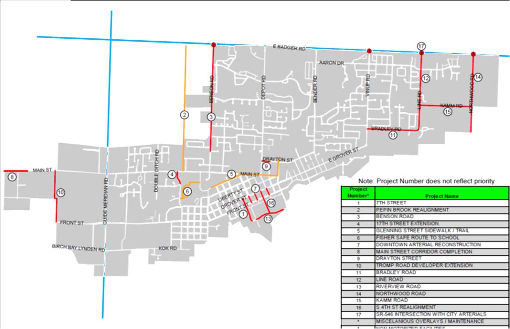
9 3 7th Street Improvements Riverview Road Extension West Main Street Bradley/Line Road Design Line Road Design Pepin Creek This project will remove a critical gap in an all-weather vehicle access to the City s Historic Business District and extend the current, Riverview Road Construction Project. 4 2


10 This project constructs the remaining section of Riverview Road between Hannegan Road and South 6th Street to full City all-weather arterial standard with two travel lanes, bike lanes, sidewalks and utilities. 5 This project will reconstruct the remaining section of Main Street, between Guide Meridian and Berthusen Road, to full City all-weather arterial standard. It will include two travel lanes, bike lanes, sidewalks and utility upgrades as needed. Intersection changes/revisions will be needed at the intersection of Main Street and Berthusen Road. 6 3


11 This project will reconstruct both Bradley and Line Roads to City arterial standard with two travel lanes, bike lanes, sidewalks and utility upgrades as needed. It is anticipated that a box culvert will be needed for one water crossing


12 Mitigate flooding impacts to 150 acres of existing City development and another 150 acres of Urban Growth Area Allows unsafe and narrow roads to be built to standard as this area is developed. Stabilize failing shoreline. Reduce road closures) caused by flooding. (incl. SR-546 Provide habitat for Cutthroat Trout, Coho, Fall Chinook, and Endangered Species Act listed winter steelhead. Double Ditch Road SR-546 Benson Road 9 10 Questions? 5


13 Our plans are to replace the water main on South Park Drive (east of Depot Road), on Van Loo Lane, and on Parkview Drive, and to repave the roadway. New water services and fire hydrants will be installed as well. 11 6
14 26/02/2016 International Mobility and Trade Corridor Program February 18, 2016 Township of Langley Presentation Outline New CBSA facility Previous queue jumping concerns Road changes during construction Long term Plan 16 Avenue Study Partners Scope Public Consultation Recommendations Preliminary Feedback 1


15 26/02/2016 Previous Concerns Previous Concerns Queue jumping from EB RT and WB LT led to RCMP callouts These turn movements were prohibited in May


16 26/02/2016 Construction Temporary Traffic Signal New Roads Closed Roads 0 Avenue closure on West side necessitated a temporary signal to be constructed at Hwy 13 and 264 Street Long-term Plan 5 lane corridor on Hwy 13 (2 NB and 3 SB) MOTI project subject to funding 0 Avenue on west side to remain closed for now Temporary signal at Hwy 13 and 264 Street to remain for now 3


17 26/02/ Avenue Study - Partners Led by Translink Includes Township of Langley, City of Surrey, City of Abbotsford, Ministry of Transportation, and ICBC High level overview of corridor Approximately 8,880 vehicles per day in 1992 Approximately 12,400 vehicles per day in 2011 Average growth rate of approx. 2.1% per year Large percentage of truck traffic at 13% -16% 16 Avenue - Traffic Volumes 4
18 26/02/ Avenue Study - Scope Examination of land uses, issues and constraints. Road hierarchy and functional use of the corridor. Examination of corridor and intersection configurations. Collection of traffic data and traffic analysis. Safety Assessment including detailed collision analysis. Traffic Modelling and analysis of Future Traffic Operations and Safety Conditions (2031) Development of Short, Medium and Long Term Corridor Improvement Options. 16 Avenue Study Public Consultation Stakeholder consultation including the Abbotsford International Airport, the Agricultural Land Commission (ALC), Chambers of Commerce, and the Metro Vancouver Parks Department. Online Open House held July 9 July 22 and October 19 November 6 Link from TOL website Notice provided via Twitter and Facebook. 5
19 26/02/ Avenue Study Recommendations Short Term Improvements (0-5 years) Sightline Improvements, additional signs and intersection lighting. RCMP pull-outs, more speed limit and radar speed warning signs. Slow moving vehicle pull-out lanes for farm vehicles. Establish a policy to reduce the number of driveways Consolidate driveways through Campbell Valley Park Wildlife fencing where feasible. 16 Avenue Study Recommendations Medium Term Improvements (6-15 years) Two-way left turn lanes in the sections with the most driveways: 184 Street to 192 Street, 192 Street to 200 Street, and 240 Street to 248 Street. Reduce the number of driveways where possible Upgrade and signalize the intersections of 208 Street, 232 Street, 272 Street, Lefeuvre Road and Bradner road when warranted. Erect additional wildlife fencing where feasible. 6

20 26/02/ Avenue Study Recommendations Long Term Improvements (15+ years) 4 lane cross section including paved shoulder, open ditches and either a raised median/barricade or two way left turn lane. 16 Avenue Study Top Concerns 7


21 26/02/ Avenue Study Phase 1 Feedback Next Steps Adoption of report by respective Councils More detailed review of Langley portion for short and medium term improvements 8
22 26/02/2016 Thank You Questions? 9
Financial Project ID No(s).: and ETDM No(s).: and 14181
.: and ETDM No(s).: and 14181") Palm Beach Metropolitan Planning Organization (MPO) Presentation I-95 at Boynton Beach Boulevard Interchange and I-95 at Gateway Boulevard Interchange Project Development and Environment Study Palm Beach
Palm Beach Metropolitan Planning Organization (MPO) Presentation I-95 at Boynton Beach Boulevard Interchange and I-95 at Gateway Boulevard Interchange Project Development and Environment Study Palm Beach
City of Wilsonville 5 th Street to Kinsman Road Extension Project
 City of Wilsonville 5 th Street to Kinsman Road Walking Tour & Neighborhood Workshop Summary Report Public Outreach Overview On July 18 th, 2017, the City of Wilsonville hosted a neighborhood walking tour
VT15 / Allen Martin Drive Intersection Scoping Study
 VT15 / Allen Martin Drive Intersection Scoping Study ALTERNATIVES PRESENTATION MEETING DECEMBER 19, 2016 Agenda Study Area Project Background Existing Conditions Identified Issues Proposed Alternatives
91 Express Lanes Model Update 2006 State Route 91 Implementation Plan. Gerald V. Nielsten May 18, 2007
 91 Express Lanes Model Update 2006 State Route 91 Implementation Plan Gerald V. Nielsten May 18, 2007 1 Vollmer Associates LLP is now Stantec Inc. Stantec Inc. completed the acquisition of Vollmer Associates
Wilshire Boulevard Bus Rapid Transit Project
 Los Angeles County Metropolitan Transportation Authority Wilshire Boulevard Bus Rapid Transit Project COMMUNITY MEETINGS November 2008 Agenda Introduction Proposed Project Overview Participating Agencies
Bicycle Crashes. Number of Bike Crashes. Total Bike Crashes. are down 21% and severe bike crashes down 8% since 2013 (5 years).
.") Bicycle Crashes The City of Fort Collins is well known for its bike culture, and there is a strong focus on encouraging increased riding. Bike safety is an important component of supporting these efforts.
Bicycle Crashes The City of Fort Collins is well known for its bike culture, and there is a strong focus on encouraging increased riding. Bike safety is an important component of supporting these efforts.
Richmond-Adelaide Cycle Tracks
 Public Drop-In Event Richmond-Adelaide Cycle Tracks June 25, 2018 12:00 p.m. 3:00 p.m. 4:30 p.m. 7:30 p.m. Metro Hall, Rotunda 55 John Street 1 Purpose of Event In Scope Communicate an update about the
KC Scout Kansas City s Bi-State Transportation Management Center
 KC Scout Kansas City s Bi-State Transportation Management Center Operations Report August- 215 This report contains statistical and operational data of activities at the Scout TMC for the period Saturday,
COMPARISON OF FIXED & VARIABLE RATES (25 YEARS) CHARTERED BANK ADMINISTERED INTEREST RATES - PRIME BUSINESS*
 CHARTERED BANK ADMINISTERED INTEREST RATES - PRIME BUSINESS*") COMPARISON OF FIXED & VARIABLE RATES (25 YEARS) Fixed Rates Variable Rates FIXED RATES OF THE PAST 25 YEARS AVERAGE RESIDENTIAL MORTGAGE LENDING RATE - 5 YEAR* (Per cent) Year Jan Feb Mar Apr May Jun Jul
COMPARISON OF FIXED & VARIABLE RATES (25 YEARS) Fixed Rates Variable Rates FIXED RATES OF THE PAST 25 YEARS AVERAGE RESIDENTIAL MORTGAGE LENDING RATE - 5 YEAR* (Per cent) Year Jan Feb Mar Apr May Jun Jul
122 Avenue: 107 Street to Fort Road
 : 107 Street to Fort Road November 24, 2015 4:30 8:00 p.m. Meeting Purpose Summarize project work completed to date Share results of public input from Phase 1 Share the draft concept plan and proposed
Freeway ramp intersection study
 Freeway ramp intersection study Supporting Vision Zero: Zero traffic deaths in San Francisco by 2024 Study Goals: Primary Improve Safety Improve Accessibility Secondary Provide Efficient Circulation Accommodate
Welcome! San Jose Avenue Open House August 25, 2015
 Welcome! San Jose Avenue Open House August 25, 2015 Vision Zero The City and County of San Francisco adopted Vision Zero San Francisco Vision Zero High Injury Network as a policy in 2014, committing an
Design Criteria. Design Criteria
 F Design Criteria Design Criteria Ministry of Transportation Ministère des Transports DESIGN CRITERIA Page: 1 of 13 WORK PROJECT NO. N/A GO Bloomington Station TYPE OF PROJECT LOCATION Bloomington Road
 Time of Change We Are Growing We Are An Attractive Place To Live We Are Age Diverse + Living Longer 50000 40000 30000 20000 10000 0 2010 Census Job Density Housing Sheds Transit Sheds The Project FUNDING
ARTINSVILLE ENRY OUNTY REA RANSPORTATION TUDY
 ARTINSVILLE ENRY OUNTY REA RANSPORTATION TUDY DEVELOPED BY THE TRANSPORTATION AND MOBILITY PLANNING DIVISION OF THE VIRGINIA DEPARTMENT OF TRANSPORTATION IN COOPERATION WITH THE U.S. DEPARTMENT OF TRANSPORTATION,
Progress Report on the Design and Planning of an Infrastructure Improvement Project for the Sunnyside TIF District (Phase II)
") Presentation to the CNRC Board of Directors Regular Meeting March 11, 2015 1 Agenda Preferred Alternate Refinement for University Avenue, 3rd Street, and Beverly Avenue Intersection Improvements validate
Presentation to the CNRC Board of Directors Regular Meeting March 11, 2015 1 Agenda Preferred Alternate Refinement for University Avenue, 3rd Street, and Beverly Avenue Intersection Improvements validate
Hennepin Avenue Reconstruction Washington Avenue to 12 th Street
 CITY OF MINNEAPOLIS Hennepin Avenue Reconstruction Washington Avenue to 12 th Street April 2016 1 Upcoming Opportunities Public Meeting #2 April 25, 2016 Minneapolis Central Library Doty Board Room Repeat
WELCOME Mission-Geneva Transportation Study
 WELCOME Mission-Geneva Transportation Study Study Process and Schedule 2005 2006 Oct Nov Dec Jan Feb Mar Apr May Jun Jul Aug Sept Oct Task 2 Develop Outreach Plan Task 3 Document Existing Conditions/ Prioritize
SR 693 (Pasadena Avenue) Corridor Study from Shore Drive South to 66 th Street
 Corridor Study from Shore Drive South to 66 th Street") Welcome and Introduction Sign-in and comment sheets Restrooms and exits Meeting agenda and timeline Meeting goals / expectations Provide input to guide study recommendations Actively participate throughout
Welcome and Introduction Sign-in and comment sheets Restrooms and exits Meeting agenda and timeline Meeting goals / expectations Provide input to guide study recommendations Actively participate throughout
Route 28 (South Orleans Road)/Route 39 (Harwich Road)/Quanset Road Intersection
/Route 39 (Harwich Road)/Quanset Road Intersection") TRAFFIC FEASIBILITY STUDY Route 28 (South Orleans Road)/Route 39 (Harwich Road)/Quanset Road Intersection Orleans, Massachusetts Prepared for: Town of Orleans Prepared by: Fay, Spofford & Thorndike, LLC
TRAFFIC FEASIBILITY STUDY Route 28 (South Orleans Road)/Route 39 (Harwich Road)/Quanset Road Intersection Orleans, Massachusetts Prepared for: Town of Orleans Prepared by: Fay, Spofford & Thorndike, LLC
Municipal Class EA To Address Traffic Congestion On The Ontario Street Corridor (Grand Bend) Public Information Meeting June 4, 2018
 Public Information Meeting June 4, 2018") Municipal Class EA To Address Traffic Congestion On The Ontario Street Corridor (Grand Bend) Public Information Meeting June 4, 2018 Background Agenda Traffic Study Update Class EA Alternatives Bridge
Municipal Class EA To Address Traffic Congestion On The Ontario Street Corridor (Grand Bend) Public Information Meeting June 4, 2018 Background Agenda Traffic Study Update Class EA Alternatives Bridge
Fleur Drive Reconstruction
 Fleur Drive Reconstruction October 29, 2018 1 Agenda: Fleur Drive Reconstruction Project Scope & Cost Overview Fleur Drive Cross Section Elements - Travel Lane Widths - Sidewalk Widths - Parkway Widths
95 Express Annual Operations Report: Fiscal Year
 95 Express Annual Operations Report: Fiscal Year 2014-2015 General The 95 Express Program completed its sixth full Fiscal Year of operations in June 2015. For the FDOT, its Fiscal Year (FY) is from July
Roundabout Feasibility Memorandum
 Roundabout Feasibility Memorandum To From Gwen Pipkin Bill Howell Date June 18, 2013 Subject Roundabout Feasibility Study SR 29 PD&E Study From Oil Well Road to SR 82 Collier County, FL FPID 417540-1-22-01
Current Travel Needs and Operating Conditions (See pages 4 9 of the Discussion Guide)
") Phase 1 Consultation: Understanding the Need Feedback Form Thank you for participating in this phase of planning for the George Massey Tunnel Replacement. Your feedback is important to us. Input received
Phase 1 Consultation: Understanding the Need Feedback Form Thank you for participating in this phase of planning for the George Massey Tunnel Replacement. Your feedback is important to us. Input received
Main-McVay Transit Study: Phase 2 Options Definition and High Level Constraints Evaluation
 Main-McVay Transit Study: Phase 2 Options Definition and High Level Constraints Evaluation APRIL 2016 A collaborative study between: For Additional Information or to Comment If you would like additional
Preliminary Transportation Analysis
 Preliminary Transportation Analysis Goals of a Robust, Multimodal Transportation Network Safe Accessible/Connected Efficient Comfortable Context-Sensitive Motor Vehicle: Continue to analyze the data to
ECONOMY PEOPLE ENVIRONMENT
 Report Back on Local Transit Improvements May 29, 2013 ECONOMY PEOPLE ENVIRONMENT Intro Council Requested Report Back Topics Progress on Planning for Broadway Subway False Creek Bridges Local Transit Improvements
Terwillegar Drive Expressway Draft Concept Plan
 Terwillegar Drive Expressway Draft Concept Plan Anthony Henday Drive to Whitemud Drive November 28 5:00-8:00 p.m. December 1 10:00 a.m. - 3:00 p.m. Let s Talk Today you can: Learn about the new direction
Encouraging Taxi Drivers to Behave: Grafton Bridge Taxi and Bus Lane Trial. Rob Douglas-Jones Tim Segedin, Edin Ltd.
 Encouraging Taxi Drivers to Behave: Grafton Bridge Taxi and Bus Lane Trial Rob Douglas-Jones Tim Segedin, Edin Ltd. 2.1km 12 mins Hospital 1.5km 9 mins To Newmarket 5 500 bikes per day 500 pedestrians
WELCOME. City of Eden Prairie West 70 th Street
 WELCOME City of Eden Prairie West 70 th Street Project Schedule Sep Oct Nov Dec Jan Feb Mar Apr May Jun Jul Aug >>> May WEST SEGMENT Concept Plan Fall 2014 Plan Development Winter 2014 Summer 2015 Construction
INDUSTRIAL BUILDING 1660 COMSTOCK ROAD CITY OF OTTAWA TRANSPORTATION OVERVIEW. Prepared for:
 INDUSTRIAL BUILDING 1660 COMSTOCK ROAD CITY OF OTTAWA TRANSPORTATION OVERVIEW Prepared for: Simluc Contractors Limited 2550 Blackwell Street, Ottawa K1B 5R1 October 18, 2013 113-584 Overview_1.doc D. J.
Anniedale - Tynehead NCP. Transportation Highway 15 & Golden Ears Way Analysis
 Highway 15 & Golden Ears Way Analysis Stage 1 Conclusions Analysis indicated capacity constraints at Highway 15 & Golden Ears Way Grade Separation required for safe and efficient traffic movement Supports
RapidRide Roosevelt Seat Sea t t le t le Depa De r pa t r men men t of Sept T an r sp an or sp t or a t t a ion
 RapidRide Roosevelt Seattle Bicycle Advisory Board 1 Our mission, vision, and core values Mission: deliver a high-quality transportation system for Seattle Vision: connected people, places, and products
Bellevue Downtown Association Downtown Bike Series
 Bellevue Downtown Association Downtown Bike Series Meeting 2 Franz Loewenherz Andreas Piller Kyle Potuzak Chris Long October 26, 2017 Today s Agenda: 1) Meeting Purpose 2) 9/28 Meeting Recap 3) Candidate
Traffic Impact Analysis Walton Acres at Riverwood Athletic Club Clayton, NC
 Traffic Impact Analysis Walton Acres at Riverwood Athletic Club Clayton, NC 1. TABLE OF CONTENTS INTRODUCTION...1 1.1. Site Location and Study Area...1 1.2. Proposed Land Use and Site Access...2 1.3.
INDUSTRIAL BUILDING 3009 HAWTHORNE ROAD CITY OF OTTAWA TRANSPORTATION OVERVIEW REVISED. Prepared for: Canada Inc.
 INDUSTRIAL BUILDING 3009 HAWTHORNE ROAD CITY OF OTTAWA TRANSPORTATION OVERVIEW REVISED Prepared for: 7849648 Canada Inc. Octiober 1, 2015 114-598 Overview_2.doc D. J. Halpenny & Associates Ltd. Consulting
10.0 CURB EXTENSIONS GUIDELINE
 10.0 CURB EXTENSIONS GUIDELINE Road Engineering Design Guidelines Version 1.0 March 2017 City of Toronto, Transportation Services City of Toronto Page 0 Background In early 2014, Transportation Services
TRASBURG RANSPORTATION
 TRASBURG RANSPORTATION LAN DEVELOPED BY THE TRANSPORTATION PLANNING DIVISION OF THE VIRGINIA DEPARTMENT OF TRANSPORTATION IN COOPERATION WITH THE U.S. DEPARTMENT OF TRANSPORTATION, FEDERAL HIGHWAY ADMINISTRATION
OTTAWA TRAIN YARDS PHASE 3 DEVELOPMENT CITY OF OTTAWA TRANSPORTATION IMPACT STUDY. Prepared for:
 OTTAWA TRAIN YARDS PHASE 3 DEVELOPMENT CITY OF OTTAWA TRANSPORTATION IMPACT STUDY Prepared for: The Ottawa Train Yards Inc. 223 Colonnade Road South, Suite 212 Nepean, Ontario K2E 7K3 January 17, 2012
Traffic Impact Study WestBranch Residential Development Davidson, NC March 2016
 Traffic Impact Study WestBranch Residential Development Davidson, NC March 216 TRAFFIC IMPACT STUDY FOR THE WestBranch Residential Development LOCATED IN DAVIDSON, NC Prepared For: Lennar Carolinas, LLC
Providence Downtown Transit Connector STAKEHOLDER MEETING #2. Stakeholder Meeting #1 October 24, 2016
 Providence Downtown Transit Connector STAKEHOLDER MEETING #2 Stakeholder Meeting #1 October 24, 2016 February 2017 1 AGENDA 1 DTC Goals and Expectations 2 Street Design Concepts 3 Potential Benefits and
JONESBORO HIGHWAY 63 HIGHWAY 18 CONNECTOR STUDY
 JONESBORO HIGHWAY 63 HIGHWAY 18 CONNECTOR STUDY Craighead County May 2007 JONESBORO HIGHWAY 63 HIGHWAY 18 CONNECTOR STUDY Craighead County May 2007 Prepared by Planning and Research Division Arkansas State
Transportation Planning Division
 Transportation Planning Division Presentation Outline Study Tasks Recap of Previous Meetings Data Collected Focus Areas within Study Limits Design Principles Tool Box Recommended Concepts Schedule Moving
Polk Streetscape Project
 What is this project? The Polk Streetscape Project is an effort to improve safety for everyone traveling on Polk Street between Union and McAllister streets. Also included in this project are paving, sewer
Traffic Impact Analysis Chatham County Grocery Chatham County, NC
 Chatham County Grocery Chatham County, NC TABLE OF CONTENTS 1. INTRODUCTION... 1 1.1. Location and Study Area... 1 1.2. Proposed Land Use and Access... 2 1.3. Adjacent Land Uses... 2 1.4. Existing ways...
DUNBOW ROAD FUNCTIONAL PLANNING
 DUNBOW ROAD FUNCTIONAL PLANNING Final Report August 3, 216 #31, 316 5th Avenue NE Calgary, AB T2A 6K4 Phone: 43.273.91 Fax: 43.273.344 wattconsultinggroup.com Dunbow Road Functional Planning Final Report
Draft Report. Traffic Impact Study. Superstore, Wal-Mart, and Kent Development. Yarmouth, Nova Scotia. Prepared for
 oad & Traffic Management Road & Traffic Management R Atlantic Traffic Engineering Specialists Draft Report Traffic Impact Study Superstore, Wal-Mart, and Kent Development Yarmouth, Nova Scotia Prepared
Highway 49, Highway 351 and Highway 91 Improvements Feasibility Study Craighead County
 Highway 49, Highway 351 and Highway 91 Improvements Feasibility Study Craighead County Executive Summary March 2015 Highway 49, Highway 351 and Highway 91 Improvements Feasibility Study Craighead County
Scarlett Road Bridge & Road Improvements Lambton Park Community School - Gymnasium Tuesday November 28 th, 2017
 Scarlett Road Bridge & Road Improvements Lambton Park Community School - Gymnasium Tuesday November 28 th, 2017 PROJECT LOCATION 2 SCARLETT ROAD BRIDGE Constructed in 1912, the bridge carries 4 active
Los Altos Hills Town Council - June 18, 2015 Palo Alto City Council June 22, AGENDA ITEM #2.B Presentation
 Los Altos Hills Town Council - June 18, 2015 Palo Alto City Council June 22, 2015 AGENDA ITEM #2.B Presentation Previous Presentations Los Altos Hills Town Council in May 2014 and February 2015 Palo Alto
5858 N COLLEGE, LLC N College Avenue Traffic Impact Study
 5858 N COLLEGE, LLC nue Traffic Impact Study August 22, 2016 Contents Traffic Impact Study Page Preparer Qualifications... 1 Introduction... 2 Existing Roadway Conditions... 5 Existing Traffic Conditions...
Intersection of Massachusetts Avenue and Maple Street in Lexington Signalized Intersection and Roundabout Comparison
 Intersection of Massachusetts Avenue and Maple Street in Lexington Signalized Intersection and Roundabout Comparison Michael Wallwork, Roundabout Expert, Orange Park, Florida Tom Bertulis (MS, PE, PTOE),
FINAL DESIGN TRAFFIC TECHNICAL MEMORANDUM
 FINAL DESIGN TRAFFIC TECHNICAL MEMORANDUM July 2014 FINAL (SR 43) Project Development and Environment Study From State Road 60 (Adamo Drive) to I-4 (SR 400) Hillsborough County, Florida Work Program Item
Brooklyn Boulevard (County Road 152) Reconstruction Project Phase I. OPEN HOUSE June 20, 2017
 Reconstruction Project Phase I. OPEN HOUSE June 20, 2017") Brooklyn Boulevard (County Road 152) Reconstruction Project Phase I OPEN HOUSE June 20, 2017 Brooklyn Boulevard (County Road 152) Phase I Project Partners Project Lead Other Project Partners include Brooklyn
Brooklyn Boulevard (County Road 152) Reconstruction Project Phase I OPEN HOUSE June 20, 2017 Brooklyn Boulevard (County Road 152) Phase I Project Partners Project Lead Other Project Partners include Brooklyn
Station Plan: Penn & 43rd Avenue
 Station Plan: Penn & 43rd Avenue This station will serve the northern portion of the Penn Avenue corridor, including the commercial node at 44th Avenue. Ridership and roadway geometry support station siting
EXECUTIVE SUMMARY... vii 1 STUDY OVERVIEW Study Scope Study Area Study Objectives
 Contents EXECUTIVE SUMMARY... vii 1 STUDY OVERVIEW... 1-1 1.1 Study Scope... 1-1 1.2 Study Area... 1-1 1.3 Study Objectives... 1-3 2 EXISTING CONDITIONS... 2-1 2.1 Existing Freeway Conditions... 2-4 2.1.1
Harrah s Station Square Casino
 Transportation Analysis Harrah s Station Square Casino Pittsburgh, Pennsylvania Submitted To: City of Pittsburgh and Pennsylvania Gaming Control Board Prepared By: DKS Associates GAI Consultants December
Station 1: Street & Sidewalk Upgrades
 Station 1: Street & Sidewalk Upgrades Existing no left turn; Potential left turn arrow, see Circulation Study boards for more information Thru-lane guidance Improved lead-in green bike lane 17TH ST CASTRO
Highway 1 Kamloops to Alberta Four-Laning Program
 Highway 1 Kamloops to Alberta Four-Laning Program COMMUNITY ENGAGEMENT DISCUSSION GUIDE AND FEEDBACK FORM February 7 March 1, 2013 www.bchwy1.ca 1 FEEDBACK FORM INSIDE HOW INPUT WILL BE CONSIDERED FAST
Princeton Avenue and Spruce Street Transportation and Site Access Enhancements Project
 Princeton Avenue and Spruce Street Transportation and Site Access Enhancements Project Mercer County Planning Division AECOM Transportation (formerly DMJM Harris) January 29, 2009 Agenda Project Status
HIGHWAY 11 CORRIDOR STUDY
 HIGHWAY 11 CORRIDOR STUDY Executive Summary August 2016 Roseau County?æA@?çA@ Warroad Lake of the Woods Roseau Roosevelt Badger?ÄA@ Greenbush Legend N Hwy 11 Study Area Figure 1: Corridor Study Limits
Boston Post Road Design Feasibility Study
 Boston Post Road Design Feasibility Study Prepared for the City of Rye Final Report July 18, 2007 Prepared by: Buckhurst Fish & Jacquemart (BFJ) 115 Fifth Avenue New York, NY 10003 www.bfjplanning.com
Snelling Bus Rapid Transit June 17, 2013 Technical Advisory Committee Meeting #2 & VISSIM Traffic / TSP Evaluation Wrap-Up
 Snelling Bus Rapid Transit June 17, 2013 Technical Advisory Committee Meeting #2 & VISSIM Traffic / TSP Evaluation Wrap-Up 1 Today s meeting Introductions VISSIM Traffic Modeling / TSP Evaluation SRF Design
Welcome to the Sellwood Bridge Project Open House!
 Welcome to the Sellwood Bridge Project Open House! 5:30 7:30 pm Please sign in here Information stations and project staff are located throughout the room. Goals for Tonight s Meeting: Learn how the Preferred
INGHAM COUNTY ROAD DEPARTMENT AUSTIN E. CAVANAUGH ADMINISTRATION BUILDING 301 Bush Street, P.O. Box 38, Mason, MI
 INGHAM COUNTY ROAD DEPARTMENT AUSTIN E. CAVANAUGH ADMINISTRATION BUILDING 301 Bush Street, P.O. Box 38, Mason, MI 48854-0038 March 27, 2018 William M. Conklin, P.E. Managing Director FOR IMMEDIATE RELEASE:
PROPOSAL: Review of Alaska DOT&PF project 68471, Glacier Highway reconstruction and pedestrian improvements from
 PROPOSAL: Review of Alaska DOT&PF project 68471, Glacier Highway reconstruction and pedestrian improvements from Fritz Cove Rd to Seaview Ave, for consistency with locally adopted plans and ordinances.
Standing Committee on Planning, Transportation and Environment
 ADMINISTRATIVE REPORT Report Date: May 13, 2013 Contact: Jerry Dobrovolny Contact No.: 604.873.7331 RTS No.: 9847 VanRIMS No.: 08-2000-20 Meeting Date: May 29, 2013 TO: FROM: SUBJECT: Standing Committee
Mandan Commission Meeting August 2, 2016 Mandan City Hall
 Mandan-Bismarck Corridor Improvement Study Mandan Commission Meeting August 2, 2016 Mandan City Hall 2014 HDR, Inc., all rights reserved. Mandan Corridors Study Schedule 2015 2016 Study Kick Off August
Swamp Road Residents Study
 Swamp Road Residents Study SRRG Meeting with PennDot and Elected Officials Newtown and Wrightstown, PA April 25, 2008 Newtown Township Section of Swamp Road Limited Public Funds No reconstruction of a
BETHEL ROAD AND SEDGWICK ROAD CORRIDOR STUDY
 DRAFT PLAN City Council Meeting August 14, 2017 STUDY AREA Sedgwick Corridor State Route 160, principal arterial with Class 3 access management designation, commuter and freight route, connection to SR
Mineral Avenue Corridor Assessment. ITE 2017 Western District Annual Meeting San Diego, CA June 21 st
 Mineral Avenue Corridor Assessment ITE 2017 Western District Annual Meeting San Diego, CA June 21 st Biography - Aaron Heumann, PE, PTOE Currently City of Littleton Transportation Engineering Manager 24
Project Advisory Group (PAG) Meeting #2 January 31, SR 693 (Pasadena Avenue) Corridor Study from Shore Drive South to 66 th Street
 Meeting #2 January 31, SR 693 (Pasadena Avenue) Corridor Study from Shore Drive South to 66 th Street") Project Advisory Group (PAG) Meeting #2 January 31, 2018 Welcome & Introductions AGENDA 1. Where are we at? 2. Project Survey / Virtual Comment Tool / PAG Meeting #1 / Visioning Workshop Corridor Map Exercise
Project Advisory Group (PAG) Meeting #2 January 31, 2018 Welcome & Introductions AGENDA 1. Where are we at? 2. Project Survey / Virtual Comment Tool / PAG Meeting #1 / Visioning Workshop Corridor Map Exercise
Alberta Highway 881. Corridor Management Plan. Session Forum 1 - Highways. Tri-Party Transportation Conference Moving Alberta Into the Future
 Tri-Party Transportation Conference Moving Alberta Into the Future Alberta Highway 881 Corridor Management Plan Lac La Biche to Anzac Session Forum 1 - Highways March 2017 INTRODUCTION + 241 km long, 2
Aurora Corridor to E Line
 Aurora Corridor to E Line Jack Whisner Transit Planner, Service Development King County Metro Transit Seattle, Washington jack.whisner@kingcounty.gov 206-477-5847 King County Metro Transit Part of general
City Council Work Session
 City Council Work Session March 7, 2019 Strategies to address traffic flow in lebanon City Council Goals Infrastructure and Utilities To improve the quality of life of our customers by providing clean,
For Information Only. Pedestrian Collisions (2011 to 2015) Resolution. Presented: Monday, Apr 18, Report Date Tuesday, Apr 05, 2016
 Resolution. Presented: Monday, Apr 18, Report Date Tuesday, Apr 05, 2016") Presented To: Operations Committee For Information Only Pedestrian Collisions (0 to 0) Presented: Monday, Apr 8, 06 Report Date Tuesday, Apr 0, 06 Type: Correspondence for Information Only Resolution For
Presented To: Operations Committee For Information Only Pedestrian Collisions (0 to 0) Presented: Monday, Apr 8, 06 Report Date Tuesday, Apr 0, 06 Type: Correspondence for Information Only Resolution For
Memorandum. Fund Allocation Fund Programming Policy/Legislation Plan/Study Capital Project Oversight/Delivery Budget/Finance Contract/Agreement Other:
 Memorandum Date: November 20, 2017 To: Transportation Authority Board From: Eric Cordoba Deputy Director Capital Projects Subject: 12/5/17 Board Meeting: San Francisco Freeway Corridor Management Study
Waterford Lakes Small Area Study
 Waterford Lakes Small Area Study Existing Traffic Conditions PREPARED FOR: ORANGE COUNTY PUBLIC WORKS DEPARTMENT TRAFFIC ENGINEERING DIVISION ORLANDO, FLORIDA PREPARED WITH: INWOOD CONSULTING ENGINEERS
City of Sammamish. Welcome. Issaquah-Fall City Road Improvements Project Phase I Design: 242nd Avenue SE to Klahanie Drive SE
 Welcome Welcome to the third community meeting for the Issaquah-Fall City Road Improvements Project. AGENDA 6:00 p.m. Welcome and sign-in 6:10 p.m. Presentation 6:50 p.m. Open house Learn about the roadway
ITEM 2.3 South of Fraser Rapid Transit Surrey-Langley technology decision. That the Mayors Council on Regional Transportation receive this report.
 TO: FROM: Mayors Council on Regional Transportation Geoff Cross, Vice President of Planning and Policy DATE: September 27, 2017 SUBJECT: ITEM 2.3 South of Fraser Rapid Transit Surrey-Langley technology
Pine Hills Road Pedestrian/Bicycle Safety Study Board of County Commissioners Work Session
 Pine Hills Road Pedestrian/Bicycle Safety Study Board of County Commissioners Work Session February 20, 2018 Meeting Agenda Study Overview Existing Conditions Access Management Potential Gateway Features
Route 79/Davol Street Corridor Study
 Route 79/Davol Street Corridor Study Fall River, MA Public Information Meeting #2 November 21, 2013 Fall River Heritage State Park Fall River, MA Agenda Welcome and Introductions Overview of Study Process
Roadway Classification Review
 District of North Vancouver 355 West Queens Road North Vancouver British Columbia V7N 4N5 Roadway Classification Review District of North Vancouver January 2013 District of North Vancouver Roadway Classification
Donahue Drive Corridor Traffic Operational Evaluation
 Donahue Drive Corridor Traffic Operational Evaluation PREPARED FOR: THE CITY OF AUBURN PREPARED BY: JANUARY 2007 Donahue Drive Corridor Study--Auburn, Alabama TABLE OF CONTENTS Introduction... 1 Background
Purpose + Need. Connect: Thrive: Develop: < Strengthen the spine of our regional transportation system
 Purpose + Need I-29 NW Barry Road 64/68/72 MAIN STREET Connect: < Strengthen the spine of our regional transportation system Leavenworth Road Parallel Parkway State Avenue 18th Street Expressway Shawnee
Agenda. Citizen Advisory Committee. CSAH 101 (CSAH 62 to Hutchins Drive) City of Minnetonka May 29, :00 pm
 City of Minnetonka May 29, :00 pm") Citizen Advisory Committee CSAH 101 (CSAH 62 to Hutchins Drive) City of Minnetonka May 29, 2012 3:00 pm Agenda 1. Introductions 2. Project Overview 3. Role of Citizen Advisory Committee 4. Citizen Advisory
Citizen Advisory Committee CSAH 101 (CSAH 62 to Hutchins Drive) City of Minnetonka May 29, 2012 3:00 pm Agenda 1. Introductions 2. Project Overview 3. Role of Citizen Advisory Committee 4. Citizen Advisory
Highway 56 Traffic Study Rymal Road to Cemetery Road
 January 31, 2018 6:00 pm 8:00 pm Highway 56 Traffic Study Rymal Road to Cemetery Road City of Hamilton Public Meeting 2 2 Purpose of Public Meeting To review and obtain public input and comments on the
Evaluation of M-99 (Broad Street) Road Diet and Intersection Operational Investigation
 Road Diet and Intersection Operational Investigation") Evaluation of M-99 (Broad Street) Road Diet and Intersection Operational Investigation City of Hillsdale, Hillsdale County, Michigan June 16, 2016 Final Report Prepared for City of Hillsdale 97 North Broad
Evaluation of M-99 (Broad Street) Road Diet and Intersection Operational Investigation City of Hillsdale, Hillsdale County, Michigan June 16, 2016 Final Report Prepared for City of Hillsdale 97 North Broad
FM 1092/Murphy Road Access Management Study Pulic Meeting #1. Wednesday, August 31, :00 p.m. 8:00 p.m.
 FM 1092/Murphy Road Access Management Study Pulic Meeting #1 Wednesday, August 31, 2011 6:00 p.m. 8:00 p.m. Introductions Agency Partners H-GAC Missouri City TxDOT Introductions Consulting Team In Association
Lincoln Avenue Road Diet Trial
 Lincoln Avenue Road Diet Trial Data Collection Report June 1, 2015 Department of Transportation Table of Contents I. Introduction...... 3 II. Data Collection Methodology & Results...... 5 A. Traffic Volume
4. ENVIRONMENTAL IMPACT ANALYSIS 9. TRANSPORTATION AND TRAFFIC
 4. ENVIRONMENTAL IMPACT ANALYSIS 9. TRANSPORTATION AND TRAFFIC 4.9.1 INTRODUCTION The following section addresses the Proposed Project s impact on transportation and traffic based on the Traffic Study
Public Works Update Safety Campaign. Second Quarter Report
 Public Works Update Safety Campaign Second Quarter Report City Council Worksession January, Citywide Collision Data,,, Overall reduction in crashes.% Its RED FOR A REASON! Control Intersections Collisions
From Mile Zero to Target Zero the Dawson Creek Case Study
 From Mile Zero to Target Zero the Dawson Creek Case Study Raheem Dilgir, President, TranSafe Consulting Ltd. and Kevin Henderson, Manager of Planning and Development, City of Dawson Creek Paper prepared
New Seward and 36 th Avenue Intersection Conceptual Design
 University of Alaska Anchorage New Seward and 36 th Avenue Intersection Conceptual Design Prepared By: Zaid S. Hussein Dana Menendez Galen Jones Civil Engineering Department Prof. Osama Abaza CE A404 Highway
U.S. HIGHWAY 50 IMPROVEMENT PROJECT
 U.S. HIGHWAY 50 IMPROVEMENT PROJECT in the City of South Lake Tahoe Project Purpose and Need Planned Improvements Project Cost and Delivery Schedule Proposed Construction Staging Project Partners: HIGHWAY
Owl Canyon Corridor Project Overview and Summary
 Owl Canyon Corridor Project Overview and Summary December 22, 2008 The Owl Canyon corridor (generally the connection between the I-25 / Larimer County Road 70 interchange and the US 287 / Larimer County
Traffic Data Overview
 George Massey Tunnel Replacement Project Traffic Data Overview DRAFT November 2015 TABLE OF CONTENTS LIST OF FIGURES... ii LIST OF TABLES... iii LIST OF DEFINITIONS... iv 1. INTRODUCTION... 1 2. HISTORICAL
Nanaimo Transportation Master Plan. Phase 1 Consultation Summary
 Nanaimo Transportation Master Plan Phase 1 Consultation Summary Transportation Advisory Committee Meeting Wednesday December 12, 2012 Agenda Study Update Phase 1 Consultation Process Phase 1 Consultation
KC Scout Kansas City s Bi-State Transportation Management Center
 KC Scout Kansas City s Bi-State Transportation Management Center Operations Report May 216 This report contains statistical and operational data of activities at the Scout TMC for the period Sunday, May