LEA BRIDGE ROAD - A STREET FOR EVERYONE Public consultation document
|
|
|
- Elvin Stewart
- 5 years ago
- Views:
Transcription

 YOUR VIEWS www.")
1 LEA BRIDGE ROAD - A STREET FOR EVERYONE Public consultation document TELL US Bakers Arms to Leyton Green Road (Section D, E, F) Leyton Green Road to Whipps Cross Roundabout (Section G) YOUR VIEWS

2 LEA BRIDGE ROAD: A STREET FOR EVERYONE Lea Bridge Road is being modernised with 15million investment to transform this key route into an attractive destination for all, with new public spaces and a world class cycle route. The Lea Bridge Road scheme aims to: Transform the look of the road into a thriving high street and place for community interaction, increasing footfall and business opportunities Make the road safer and more attractive for all Make walking and cycling a more attractive and convenient option for local people Smooth traffic flow by upgrading junction signals and improving the borough s road network as whole. Lea Bridge Road is one of three routes linking our residents to neighbouring boroughs, running from the Whipps Cross Roundabout to the borough boundary with Hackney, and is heavily used with up to 30,000 vehicles and 1,500 cyclists using it every day. With Lea Bridge Road Station opening next year, the area is set to become a key transport hub. This investment, along with Mini-Holland funding, will build upon the recent Bakers Arm regeneration to increase pedestrian footfall and provide an excellent opportunity for businesses to thrive. The proposed programme will upgrade junctions, bridges and footways, create attractive public spaces with more trees, offer safer routes to school and healthier travel options making the area a more enjoyable place that people will want to visit. Over the past five years, collisions resulting in injury to people who walk and cycle have increased. Between 2009 and 2013, a total of 118 cyclists and 60 pedestrians were injured on the road, including 20 serious collisions and one fatality. Changes are needed on Lea Bridge Road to reduce collisions making the area safer for the community. Lea Bridge Road 2
3 SCHEME OVERVIEW Working with residents and businesses We understand the importance of early and on-going involvement of the local community to help shape the plans. Over 1,300 people and 175 businesses have already provided us with feedback on the area through our perception survey in March The top line results are outlined below and can be viewed by visiting 50 per cent of survey respondents would like safer crossing points 53 per cent wanted more plants and trees 55 per cent would like to see protected cycle lanes. Map overview by section Section H We have already consulted on sections A and H of the road and are now seeking your feedback on our proposed improvements, for sections D, E, F and G, so that we can develop a scheme that meets the needs of the local community as a whole. You can also feedback on proposals for Section B and C of Lea Bridge Road until 25 November by visiting 3
4 Working with communities and services We have been seeking the views of key groups and services in the area including the emergency services, schools, and religious and community groups to understand their requirements, as well as ensuring that concerns are dealt with at an early stage. We understand that these groups play an important role within the community and will continue to work with them to develop a scheme that improves the area without impacting negatively on key services. Consultation approach We want everyone who lives, works and uses Lea Bridge Road to have their say on the latest sections of the scheme. We will aim to ensure that people understand the improvements, the reasons behind them as well as the potential benefits that they may bring. We are asking for section by section comments and feedback, and would like you to rate the plans and think about how they can be further improved. Your feedback will then be used to shape the final design. The consultation will be managed in sections over the following timescales: Section Boundary Date Section A Section B Section C Section DEF Section G Section H Borough boundary with Hackney to the Lammas Road junction Lammas Road junction to Markhouse Road/ Church Road junction Markhouse Road/ Church Road junction to Bakers Arms Bakers Arms to Leyton Green Road Leyton Green Road to Whipps Cross Roundabout Whipps Cross Roundabout June to July completed 30 October to 25 November 30 October to 25 November 9 November to 2 December 9 November to 2 December June to July completed 4
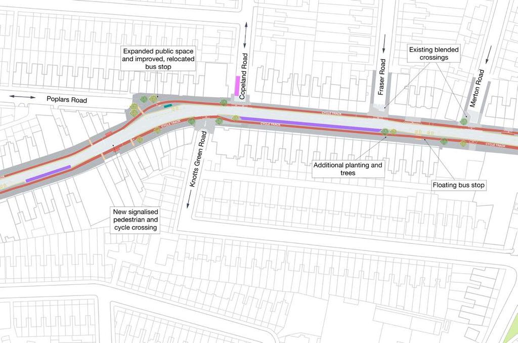
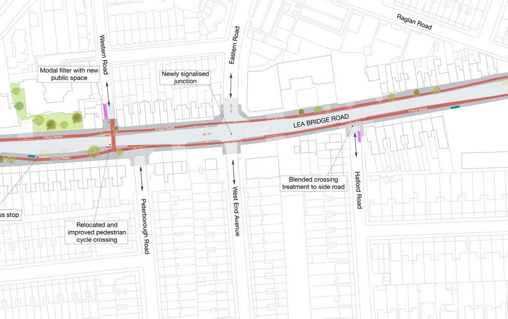
5 SCHEME PROPOSALS Engagement activities earlier this year allowed us to design a scheme which we believe will enhance and improve Lea Bridge Road for the whole community. A proposal for Section D, E, F and G of Lea Bridge Road has been developed based on the results of the perception surveys carried out earlier in the year, information on traffic movements, traffic survey data, bus information and traffic modelling. For example, 50 per cent of respondents to the perception survey wanted safer crossings, 55 per cent wanted to see protected cycle lanes and 53 per cent wanted more plants and trees, also many of the businesses were concerned about parking and loading, and so these have been built into the improvements. Local people and road users have told us that reducing traffic volumes and creating a safer environment are key priorities. In response, improvements to the area will increase safety by introducing new crossing points, a 20mph speed limit, upgrading junctions and creating new protected cycle lanes (called segregated cycle tracks) that separate people who cycle from pedestrians and vehicles. By increasing safety more local people will be encouraged to walk and cycle, which in turn will help to reduce congestion on the roads. Overview of proposals for Section D, E, F Segregated cycle tracks, one on each side of the road New and improved single stage pedestrian and cycle crossings which allow the user to cross without the need to wait at an island Junction improvements to make the road easier to navigate and safer for all road users Bus shelter improvements including new bus stops Modal filters (roads accessible to pedestrians and cycles only) at three junctions, to reduce vehicle collisions Public space improvements along the street and at Poplars Road and Bakers Arms junction Upgraded traffic signals to help manage traffic flow 20mph speed limit to make the route safer for all. Overview of proposals for section G Segregated cycle tracks, one on each side of the road Upgraded and improved single stage pedestrian and cycle crossings New and upgraded traffic signals at the junction of Lea Bridge Road with Eastern Road and West End Avenue, and Lea Bridge Road with Leyton Green Road and College Road Junction improvements at side roads to make it easier to navigate and safer for all road users Bus shelter improvements as well as upgraded existing bus stops Public space improvements at Leyton Green, Essex Road shops and Western Road Upgraded traffic signals to help manage traffic flow 20mph speed limit to make the route safer for all. 5

6 SCHEME PROPOSALS: Bakers Arms to Leyton Green Road (Section D, E, F) 6

7 7

8 SCHEME PROPOSALS: Leyton Green Road to Whipps Cross Roundabout (Section G) 8
9 9


10 SCHEME PROPOSALS: Landscaping and public spaces Landscaping and planting scored highly in the perception survey, therefore we understand how important public spaces are to you. The addition of new public space helps to instil a sense of pride in a neighbourhood, whilst encouraging people to spent time in the area and shop locally. We will modernise the road with more efficient drainage systems to reduce the risk of flooding, improve the look with new plants such as low maintenance wildflowers and orchard trees, as well as increased on street tree planting. The following public spaces have been identified on Lea Bridge Road that we would like to improve with help of the local community: Section of road by Western Road Section G: Essex Road corner Improve the public space on the corner of Essex Road, retaining the mature trees and introducing new trees, plants, cycle parking and seating. These changes along with new blended crossings will create an attractive place for bus passenger, businesses and the community. Western Road Section of road by Essex Road corner Create a public space at the new modal filter (road accessible to pedestrians and cycles only) at Western Road with trees, plants and cycle parking, making the area more attractive for businesses and local residents. 10

11 New and improved crossings New and improved crossings have been proposed in sections D, E, F and G which will benefit from a range of improvements including upgraded traffic signals, continuous single stage signalled crossings, an increase in crossing points at more convenient locations taking into consideration local amenities, separate signals for cycles and pedestrians to provide more comfortable and continuous journeys, and new elephant footprint road markings, which indicate to motorists where cycles can expect to cross the road. Section D, E, F: Convert the existing zebra crossing between numbers 611b and 613 Lea Bridge Road into a signalised pedestrian and cycle crossing to make it safer and easier to cross. Section G: Remove the pedestrian island currently to the west of Shernhall Street and the pedestrian island east of Essex Road and replace it with a new and improved pedestrian and cycle crossing Upgrade the existing crossing point near Western Road, and relocate it to the Western Road junction Replace the staggered pedestrian crossing by Raglan Road and the pedestrian island just east of Halford Road with a pedestrian and cycle crossing at the new signalised junction on Wood Street (part of the Section H Whipps Cross junction plans) Remove the existing pedestrian island opposite Shernhall Street. The safety camera at this location will be relocated. New pedestrian and cycle crossing 11


12 SCHEME PROPOSALS: Improved junctions and side road junctions Bakers Arms junction improvements Blended Copenhagen Crossing Local people have told us that reducing the amount of traffic and creating safer places to cross on Lea Bridge Road are key concerns. In response, the scheme will introduce a number of road safety and junction upgrades in sections D, E, F and G to prioritise pedestrians and slow down traffic. As well as increased safety, these junctions will benefit from new and improved monitored traffic signals that will be installed along the full route, providing efficient road management in the aim of relieving congestion during busy periods. Proposed improvements include blended Copenhagen Crossings which are commonplace in European cities that are renowned for being cycle and pedestrian friendly. When using blended crossings vehicles must give way to pedestrians and cyclists and slow down upon entering or exiting the side road. The crossings visually appear as a continuation of the footway. As well as making the borough more attractive, this style of crossing serves an important purpose as a traffic calming measure. Section D, E, F: Introduce blended Copenhagen crossings on all side road junctions open to traffic to prioritise people crossing side roads. Please refer to the overview map on page six for exact locations. o The proposals for the Bakers Arms junction build on the recent regeneration improvements and aim to make this area an even better place to visit and spend time. o Change and upgrade the junction layout to improve accessibility, safety and navigation, whilst providing more protection for pedestrians and people on cycles o Replace existing traffic signal with new and improved monitored signals that will be installed along the full route o Improve existing public spaces with plants and trees whilst accommodating changes to the road layout. 12


13 Section G: Introduce blended Copenhagen crossings on all side road junctions open to traffic to prioritise people crossing side roads. Please refer to the overview map on page eight for locations. Leyton Green Road junction improvements Replace existing traffic signal with new and improved signals that will be installed along the full route New pedestrian and cycle crossing at the junction with Leyton Green Road and the western approach of Lea Bridge Road Improve existing green spaces with meadow plants, trees, seating as well signage to highlight key landmarks and places of interest. Eastern Road/ West End Avenue junction improvements Upgrade the Eastern Road/ West End Avenue junction to manage the high volume of vehicles using the junction Replace existing traffic signal with new and improved signals that will be installed along the full route Raise the junction to pavement level and retain the crossing islands to help pedestrians cross more easily Introduce a new signalised junction to help vehicles exiting Eastern Road onto Lea Bridge Road and to ensure safety for all road users Introduce a new signalised crossing for people on cycles. 13

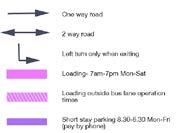
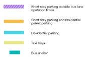
14 SCHEME PROPOSALS: New cycle lane Parking and loading improvements It s essential that parking and loading improvements meet the needs of local businesses who are vital to the community and local economy. We ve already met with businesses and visitors to understand their requirements and invite further feedback through this consultation. We will continue to work with local businesses to ensure their requirements are considered. The parking and loading arrangements along the street have been fully revised and formalised making it clearer for everyone. Permit holder bays - available for holders of resident or business permits to use only. Double yellow lines - no waiting at any time, however loading is permitted providing vehicles are not causing an obstruction to the highway. Disabled permit holders can also park for a maximum of three hours. Fully segregated cycle track Lea Bridge Road will benefit from the creation of a segregated cycle track on each side of the road to transform this key route for people who cycle. It will provide a safe space for people to cycle on, separated from motorised traffic, which is proven to increase cycling as people who would like to cycle feel more confident to do so. This type of cycle lane will also reduce confusion and conflict among all road users by creating the cycle track on a slightly lower level to the footway, making the cycle track a different colour and material to the footway and road, and by making drivers feel more at ease. Where necessary, existing access to off street parking will be maintained across the cycle track including drop kerb access. Where vehicles parked for loading would impact on traffic flow or may cause safety issues no loading at any time restrictions will apply. These restrictions also mean disabled permit holders cannot park on these sections. Loading - to provide for the needs of businesses we ve created bays reserved for loading and unloading of goods only. People using loading bays must be seen to be loading and unloading. Cycle parking - cycle parking will be increased throughout Lea Bridge Road, particularly in areas of shops, businesses and other local attractions. Side road junctions and modal filter areas will also be used to increase cycle parking. 14

15 Bus stop and bus lane changes To make bus journeys more convenient and accessible, new bus stops and shelters will be introduced at the following locations: Section G: To the east of Leyton Green Road Next to Shernhall Street To the west of Western Road * To the west of Raglan Road. Example of a cycle lane and floating bus stop We want to help improve the reliability of bus services and meet TfL s accessibility standards to help passengers with impaired mobility, as well as people with push chairs. To do this, changes will be made to bus stops and bus lanes, which will be designed in conjunction with the new cycle tracks. Improving public transport facilities in the area will encourage more local people to choose this mode of transport over personal motor vehicles which will help to relieve congestion on the road. We have been working closely with TfL on these designs and have used traffic data and average bus journey times (peak and off peak) to understand how the road may be impacted. As the bus lane is only in operation during peak hours, the bus lanes have proven to have little impact on bus journey times and so it is anticipated that changing the bus lanes in some sections of the road will have a minimal impact on the overall bus journey times in the borough. The following changes will take place at existing locations to make space for other road improvements for pedestrians as well as people who cycle. Section D, E, F: Upgrade the bus stop outside 613 and relocate it to the end of Poplar Road where there is more space to accommodate bus passengers Upgrade the bus stop next to the entrance to the Stanley Road car park and relocate it to outside 557 Lea Bridge Road Upgrade the existing bus stop on the south side of Lea Bridge Road between Fraser Road and Merton Road. Section G: Remove the eastbound bus lane. 15

16 SCHEME PROPOSALS: Modal filters (roads accessible to pedestrians and cycles only) Collisions involving people on cycles often occur when vehicles turn into and out of minor side roads. To reduce collisions in the area, we are proposing to introduce permanent road filters at the below locations. The modal filters help to improve safety for the local community, in particular children and the elderly, whilst creating more attractive residential streets, providing a place suitable for people to play out, relax and spend time with neighbours. These filters will affect motorised vehicles, and only people who walk and cycle will be able to pass through the road. Where a filter is installed, space will be provided to allow vehicles to turn around (on side streets) where possible, access for other vehicles such as for deliveries and bin collections will be maintained and residents will still have access to their street. We will continue to consult with the emergency services to ensure access is maintained. Modal filter on Poplar Road Section D, E, F: Create a new shared space at the junction of Poplar Road/Lea Bridge Road, making the road accessible to cycles and pedestrians only at this point. This area will benefit from a new bus stop, signalised pedestrian and cycle crossing, as well as new plants and trees making the junction more attractive and safer for the community. To accommodate these changes, Poplar Road will become a two way road, and motor vehicles will be able to access and exit Poplar Road from Hoe Street. Section G: Introduce a permanent modal filter (road accessible to pedestrians and cycles only) at the Western Road/ Lea Bridge Road junction to make space for a new pedestrian and cycle crossing. 16

17 We want to hear your views We hope you like the plans described and shown on the maps. We want to hear your thoughts on the proposed improvements to ensure the changes meet the needs of the local community and road users. Please provide feedback by 2 December Your feedback will help inform the final scheme. There are lots of ways to get involved: 1) View the improvements and complete the consultation questionnaire online at 2) Request a hardcopy of the consultation document and questionnaire by ing miniholland@walthamforest.gov.uk or calling ) Visit our information point on Lea Bridge Road on selected dates. Details available on our website. What happens next? All of the feedback received from the consultation will be carefully analysed and considered as part of our final designs. Where possible, we will try to incorporate everyone s suggestions, and where this is not possible we will try to explain why. We will produce a summary of the results that we will feedback to everyone who took part, setting out the results and how they have been used. All of these plans are subject to Transport for London s approval and we are continually working with them to ensure the proposals work for London s traffic and transport network overall. For more information on the Mini-Holland Programme visit 17
18 Survey results Headline results from the early engagement surveys 50% Safer crossing points 48% Less traffic Top four changes respondents would like to see to make Lea Bridge Road more pleasant for walking and cycling 53% More plants and trees 55% Protected cycle lanes 40% Traffic volume 19% Poor pedestrian environment Lea Bridge Road Visitor problems 22% Traffic congestion How respondents travel on Lea Bridge Road 32% Poor crossing points 19% Anti-social behaviour 18% lack of places to sit 60% of respondents feel that some places on Lea Bridge Road don t feel safe 36% said it is easy to get around 51% think some places are unattractive 18 75% walk use public 61% transport 47% take the car 36% cycle 38% feel some areas don t feel like a community
19 Top four changes visitors to Lea Bridge Road would like to see 36% crossing Better points 23% More street greening 23% Less traffic 37% More attractive streets 33% Less traffic Businesses on Lea Bridge Road think their customers travel to the area: by car 63% walk 49% public transport 41% cycle 12% However, visitors said they travelled: Top changes businesses on Lea Bridge Road would like to see 25% Better retail/business mix 32% More attractive streets by car 20% walk 64% public transport 54% 29% More street greening To view all of the results from the surveys and for more information on the Mini-Holland Programme visit cycle 12% Vs The top four things businesses think will improve access to Lea Bridge Road for their customers 57% better car parking 43% better located car parking 22% better crossings 20% less traffic P The top four things visitors think will improve access to Lea Bridge Road 32% better crossings 31% less traffic 24% protected cycle lanes 21% pedestrian signage 19
20
MARKHOUSE ROAD IMPROVEMENTS
 MARKHOUSE ROAD IMPROVEMENTS www.enjoywalthamforest.co.uk Waltham Forest is changing and we want you to be part of it. Thanks to a funding pot of 27million from Transport for London, we re delivering the
Lea Bridge Road A street for everyone Tell us
 Lea Bridge Road A street for everyone Tell us Public consultation document Section H your views 1 Lea Bridge Road: a street for everyone Introduction Mni-Holland is an exciting programme to improve walking
CHURCH ROAD. Public consultation document TELL US YOUR VIEWS.
 CHURCH ROAD Public consultation document YOUR TELL US VIEWS www.enjoywalthamforest.co.uk CHURCH ROAD Introduction Waltham Forest Council was one of three boroughs to be awarded 27million of funding from
BYRES ROAD: PUBLIC REALM Public Consultation
 Public Consultation Introduction As a vibrant commercial, shopping and residential location within the heart of the West End Byres Road is an important destination. Its proximity to the University of Glasgow
Cabinet Member for Highways & Streetscene. Highway Infrastructure Manager
 LONDON BOROUGH OF RICHMOND UPON THAMES DATE: AUGUST 2015 DECISION MAKER: LEAD OFFICER: SUBJECT: WARDS: Cabinet Member for Highways & Streetscene Highway Infrastructure Manager PROPOSED CYCLING IMPROVEMENTS
Leyton to Blackhorse Road Route Markhouse Road Section
 LONDON BOROUGH OF WALTHAM FOREST Meeting Date: PLM 14 April 2016 Title: Directorate: Report of: Contact: Mini Holland Leyton to Blackhorse Road Route Markhouse Road Section Neighbourhoods Head of Highways
The Cabinet Member for Highways & Streetscene. Aurang Zeb - Head of Highways & Transport
 LONDON BOROUGH OF RICHMOND UPON THAMES Cabinet Member Decision DATE: January 2012 REPORT OF: LEAD OFFICER: SUBJECT: WARDS: The Cabinet Member for Highways & Streetscene Aurang Zeb - Head of Highways &
HISTON ROAD Have your say on better public transport, cycling and walking journeys
 HISTON ROAD Have your say on better public transport, cycling and walking journeys Have your say: Please complete the survey inside this leaflet or online at www.greatercambridge.org.uk/histonconsultation
Public Consultation on Braintree Integrated Transport Package (ITP) HAVE YOUR. Consultation open from 24 September to 5 November 2018 SAY
 HAVE YOUR. Consultation open from 24 September to 5 November 2018 SAY") Public Consultation on Braintree Integrated Transport Package (ITP) HAVE YOUR SAY Consultation open from 24 September to 5 November 2018 Contents Introduction 3 Background 4 Springwood Drive Roundabout
Public Consultation on Braintree Integrated Transport Package (ITP) HAVE YOUR SAY Consultation open from 24 September to 5 November 2018 Contents Introduction 3 Background 4 Springwood Drive Roundabout
ENFIELD TOWN THE REVISED DESIGN
 TOWN THE REVISED DESIGN We re turning Enfield into a borough that encourages walking and cycling, a place that s easy for all of us to get around however we choose to travel. A greener place, with safer
Guide to the Cycle Enfield Public Consultation on Enfield Town. Produced by the Save Our Enfield Town Campaign Group
 Guide to the Cycle Enfield Public Consultation on Enfield Town Produced by the Save Our Enfield Town Campaign Group What s in this guide? Introduction Page 3 What Enfield Council says about Option 1 Page
Background. Caversham a vision for the future. Joint public meeting arranged by:
 Joint public meeting arranged by: Sharing our Streets Caversham a vision for the future and Caversham Traders Association This presentation followed a presentation by Simon Beasley, Network Manager for
MILTON ROAD LLF PROJECT UPDATE
 Greater Cambridge City Deal MILTON ROAD LLF PROJECT UPDATE 9 th May 2017 Project objectives Comprehensive priority for buses in both directions wherever practicable; Additional capacity for sustainable
Chelmsford City Growth Package
 Chelmsford City Growth Package Public Consultation Document Volume 2 West Chelmsford July - August 2017 Chelmsford City Growth Package Public Consultation Document - Volume 2 - West Chelmsford Contents
London Cycle Network Annual Report 2000
 London Cycle Network Annual Report 2000 A cycle network for London by 2005 A cycle network for London by 2005 The London Cycle Network will: provide local links between residential neighbourhoods, railway
Walthamstow Village: trial results and workshop summary
 Walthamstow Village: trial results and workshop summary Introduction The London Borough of Waltham Forest was one of three boroughs awarded 30m by Transport for London (TfL) in March 2014 as part of the
Appendix 12 Parking on footways and verges
 Appendix 12 Parking on footways and verges Legal position Parking on footways and verges whether wholly or partly is banned throughout London, unless signs are placed to allow parking. The ban requires
IAN WHITE ASSOCIATES. Crawley Station Gateway Public Realm
 IAN WHITE ASSOCIATES Crawley Station Gateway Public Realm contents 1. objectives & client brief 2. site appraisal 3. best practice guidance 4. design concept 1. objectives & client brief Crawley Train
Cycle Superhighway 4 from Tower Bridge to Greenwich
 Cycle Superhighway 4 from Tower Bridge to Greenwich About Sustrans Sustrans is the charity making it easier for people to walk and cycle. We are engineers and educators, experts and advocates. We connect
March Maidstone Integrated Transport Strategy Boxley Parish Council Briefing Note. Context. Author: Parish Clerk 2 March 2016
 Context. Author: Parish Clerk 2 The Draft Integrated Transport Policy (DITS) sets out a vision and objectives, and identifies a detailed programme of interventions to support the Maidstone Borough Local
Tonight is for you. Learn everything you can. Share all your ideas.
 Strathcona Neighbourhood Renewal Draft Concept Design Tonight is for you. Learn everything you can. Share all your ideas. What is Neighbourhood Renewal? Creating a design with you for your neighbourhood.
Easton Safer Streets - Final Project Report BRISTOL
 - Final Project Report BRISTOL A Sustrans Community Street Design Project in partnership with Bristol City Council February 07 About Sustrans Sustrans makes smarter travel choices possible, desirable and
Bristol City Council has produced a draft Bristol Transport Strategy document.
 Bristol Transport Strategy Summary Document Introduction Bristol City Council has produced a draft Bristol Transport Strategy document. The Strategy fills a gap in transport policy for Bristol. We have
20mph. We want to make Edinburgh a better and safer place to live, work and play.
 20mph CREATING A BETTER SAFER EDINBURGH We want to make Edinburgh a better and safer place to live, work and play. That s why on 13 January 2015 Councillors approved a new speed limit network for Edinburgh
Oxford Street West. 21 December https://consultations.tfl.gov.uk/roads/oxford-street/?cid=oxford-street
 Oxford Street West 21 December 2017 https://consultations.tfl.gov.uk/roads/oxford-street/?cid=oxford-street This consultation response is on behalf of the London Cycling Campaign (LCC), the capital s leading
2014/2015 BIKE ROUTE PLAN 83 AVENUE PROTECTED BIKE LANE
 About the Project 2014/2015 BIKE ROUTE PLAN The City of Edmonton is planning a major bike route on the south side of Edmonton. This bike route is one part of a plan to provide citizens with transportation
Douglas Land Use and Transportation Strategy (DLUTS) Summary. August 2013
 Summary. August 2013") Douglas Land Use and Transportation Strategy (DLUTS) Summary August 2013 Background Douglas is a large and popular residential suburb of approximately 30,000 persons on the periphery of Cork City along
Douglas Land Use and Transportation Strategy (DLUTS) Summary August 2013 Background Douglas is a large and popular residential suburb of approximately 30,000 persons on the periphery of Cork City along
Sevenways Roundabout, and the need for a Road Safety Scheme:
 Sevenways Roundabout, and the need for a Road Safety Scheme: The way the current roundabout has evolved has obviously created an environment that is dangerous for all road users, motorists, cyclists and
2. Context. Existing framework. The context. The challenge. Transport Strategy
 Transport Strategy Providing quality connections Contents 1. Introduction 2. Context 3. Long-term direction 4. Three-year priorities 5. Strategy tree Wellington City Council July 2006 1. Introduction Wellington
Mumford Terminal Replacement Opportunities Neighbourhood Open House. we are here. PHASE 2 Identifying and Evaluating Candidate Sites
 Welcome Replacement Opportunities Neighbourhood Open House. AGENDA PURPOSE 1. REVIEW the information boards 2. DISCUSS aspects of the project with the project team 3. SHARE your thoughts on replacement
Have your say on the transformation of Oxford Street West
 Have your say on the transformation of Oxford Street West About Living Streets We are Living Streets, the UK charity for everyday walking. We want to create a walking nation, free from congested roads
CUERDEN TRANSPORT PROPOSALS
 1 CUERDEN TRANSPORT PROPOSALS The transport assessment, submitted with the Cuerden development planning application, looks at access to the site and the impact on the local road network in detail. This
Your views are important. Please fill in a form before you leave. Or alternatively
 Drum Property Group is delighted to welcome you to this exhibition which sets out our initial proposals for a mixed-use development at Stead s Place, Edinburgh. We are keen to hear the views of local people
A127/A130 Fairglen Interchange Improvement Schemes. Information Leaflet February 2017
 A127/A130 Fairglen Interchange Improvement Schemes Information Leaflet February 2017 1 2 Foreword By Councillor Kevin Bentley Essex is continuing to grow as a vibrant economic hub and as a fantastic place
Frequently asked questions (FAQ) about a borough-wide 20 mph speed limit
 about a borough-wide 20 mph speed limit") Frequently asked questions (FAQ) about a borough-wide 20 mph speed limit February 2013 1. Is it safer to drive at 20 mph? Yes. According the Royal Society for Prevention of Accidents (RoSPA) if a pedestrian
Frequently asked questions (FAQ) about a borough-wide 20 mph speed limit February 2013 1. Is it safer to drive at 20 mph? Yes. According the Royal Society for Prevention of Accidents (RoSPA) if a pedestrian
Living Streets response to the Draft London Plan
 Living Streets response to the Draft London Plan Contents Living Streets response to the Draft London Plan... 1 About Living Streets... 2 Summary... 2 Consultation response... 3 Chapter 1: Planning London
Complete Streets. Designing Streets for Everyone. Sarnia
 Complete Streets Designing Streets for Everyone Sarnia Complete Streets ~ Sarnia ~ 2018 Introduction Our City is made up of a network of streets that we use to go for a walk, cycle to work, drive to the
FAQ s Walsh Road / Ferguson Road Pilot Scheme
 FAQ s Walsh Road / Ferguson Road Pilot Scheme What is happening? Traffic calming measures are being installed as a pilot. Temporary Bollards will be installed to the east of 1 Ferguson Road and a Temporary
How do we design for pedestrians? Case study: transforming the Walworth Road
 How do we design for pedestrians? Case study: transforming the Walworth Road David Moores, Director of Public Realm Institution of Highways and Transportation, November 2009 Presentation overview Design
Milton Road Project Update. Paul van de Bulk 30 January 2018
 Milton Road Project Update Paul van de Bulk 30 January 2018 Milton Road Project Objectives Comprehensive priority for buses in both directions wherever practicable; Safer and more convenient routes for
Report to Cabinet. 18 May 2016
 Agenda Item 8 Report to Cabinet 18 May 2016 Subject: Presenting Cabinet Member: Proposed CCTV Enforcement of Traffic Contraventions in a Bus Lane (Key Decision Ref. No. HE030) Highways and Environment
Mill Hill Broadway Capacity Improvement
 1 16 MARCH 2016 Mill Hill Broadway Capacity Improvement Presentation to Barnet Members and Mill Hill Residents Association 2 Background A1 is one of 23 Transport for London Road Network (TLRN) Strategic
Part 3: Active travel and public transport planning in new housing developments
 1 Linking active travel and public transport to housing growth and planning Part 3: Active travel and public transport planning in new housing developments Active Travel Toolkit Slide Pack July 2017 Linking
Governance and Priorities Committee Report For the July 2, 2015 Meeting
 CITY OF VICTORIA For the July 2, 2015 Meeting To: Governance and Priorities Committee Date: From: Subject: Brad Dellebuur, A/Assistant Director, Transportation and Parking Services Executive Summary The
RESTRICTED ROADS (20 MPH SPEED LIMIT) (SCOTLAND) BILL. 1. Is reducing the speed limit to 20mph the best way of achieving the aims of the Bill?
 (SCOTLAND) BILL. 1. Is reducing the speed limit to 20mph the best way of achieving the aims of the Bill?") RURAL ECONOMY AND CONNECTIVITY COMMITTEE RESTRICTED ROADS (20 MPH SPEED LIMIT) (SCOTLAND) BILL SUBMISSION FROM CYCLE STIRLING Questions 1. Is reducing the speed limit to 20mph the best way of achieving
RURAL ECONOMY AND CONNECTIVITY COMMITTEE RESTRICTED ROADS (20 MPH SPEED LIMIT) (SCOTLAND) BILL SUBMISSION FROM CYCLE STIRLING Questions 1. Is reducing the speed limit to 20mph the best way of achieving
2014/2015 BIKE ROUTE PLAN 83 AVENUE PROTECTED BIKE LANE
 About the Project The City of Edmonton is planning a major bike route on the southside of Edmonton. The Strathcona Bike Route will connect the communities of Strathcona, Garneau and the University area,
REF. PE01595: MORATORIUM ON SHARED SPACE SCHEMES
 PE1595/RRR Sustrans submission of 17 March 2017 Following the Public Petitions Committee meeting on 9 th February 2017 you wrote to Sustrans Scotland requesting a clarification on our position on the use
GLEN EIRA CITY COUNCIL. MURRUMBEENA Transforming our neighbourhood together our concepts based on your ideas
 GLEN EIRA CITY COUNCIL MURRUMBEENA Transforming our neighbourhood together our concepts based on your ideas 1 WHAT HAVE WE HEARD? WHAT NOW? Stage one Tell us what you love about your shopping strip November
High frequency bus services operating to Little Island; Creation of a new Park and Ride site and train station at North Esk;
 Cork County Council 7 th December 2018 Dear Adrian O Neill (aoneill@jbbarry.ie) The Transport and Mobility Forum, Cork (TMF) is a representative group of organisations who have a common interest in sustainable
CAMBOURNE TO CAMBRIDGE BETTER PUBLIC TRANSPORT PROJECT PHASE 2 PUBLIC CONSULTATION MADINGLEY MULCH ROUNDABOUT TO CAMBOURNE
 CAMBOURNE TO CAMBRIDGE BETTER PUBLIC TRANSPORT PROJECT PHASE 2 PUBLIC CONSULTATION MADINGLEY MULCH ROUNDABOUT TO CAMBOURNE Have your say on proposals for a new public transport link and Park & Ride facility
DESIGN CODE. Enterprise West Harlow London Road North Design Code 21
 DESIGN CODE Enterprise West Essex @ Harlow London Road North Design Code 21 4 MAXIMUM BUILDING HEIGHTS 4.1 Table 4A sets out maximum building height standards for each character area within the LDO boundary.
Nottingham Cycle City Frequently Asked Questions
 Nottingham Cycle City Frequently Asked Questions About the scheme How much money is to be spent on cycling? And where is the money from? We have 6.1 million in Growth Fund which we will be investing directly
M6 Junction 10 Public Consultation
 M6 Junction 10 Public Consultation December 2015 Introduction Walsall Council and Highways England are developing plans to provide a long term improvement to M6 junction 10. We are holding this non-statutory
ENJOY WALTHAM FOREST WALKING AND CYCLING ACCOUNT
 ENJOY WALTHAM FOREST WALKING AND CYCLING ACCOUNT www.enjoywalthamforest.co.uk ENJOY WALTHAM FOREST WALKING AND CYCLING ACCOUNT 2 www.enjoywalthamforest.co.uk Contents ENJOY WALTHAM FOREST WALKING AND CYCLING
Low traffic neighbourhoods
 Low traffic neighbourhoods PHOTO: ELAINE KRAMER What, why, how? What low traffic neighbourhoods are, why you should be considering them in your borough and how to make sure they work well the five minute
Update June 2018 OUR 2017 PUBLIC ENGAGEMENT
 Update June 2018 Hi, Let s Get Wellington Moving (LGWM) is developing a Recommended Programme of Investment (RPI) that meets our programme objectives and supports the city s and region s growth. As part
Public Information Centre
 WELCOME Public Information Centre Father Tobin Road Lougheed Middle School - Library Wednesday November 7, 2012 7:00 p.m.to 9:00 p.m. Please sign in Neighbourhood Traffic Calming Guide Background The City
sessions. The opinions of local people will help decide which of these two options is taken forward to be built.
 A4018 FAQs Why are no bus lanes proposed north of Crow Lane? Inbound and outbound bus lanes were considered north of the Crow Lane junction, but they took away capacity from other traffic on the approach
122 Avenue: 107 Street to Fort Road
 : 107 Street to Fort Road November 24, 2015 4:30 8:00 p.m. Meeting Purpose Summarize project work completed to date Share results of public input from Phase 1 Share the draft concept plan and proposed
14. PROPOSED PEDESTRIAN CROSSING IMPROVEMENTS IN MOORHOUSE AVENUE
 165 14. PROPOSED PEDESTRIAN CROSSING IMPROVEMENTS IN MOORHOUSE AVENUE General Manager responsible: General Manager City Environment, DDI 941-8528 Officer responsible: Transport and Greenspace Unit Manager
TRANSPORT AND MOVEMENT
 TRANSPORT AND MOVEMENT Movement Strategy Public Transport Cycling and Walking Road Network Parking Standards Transport Impact Assessments Traffic Management Policies DRAFT POOLBEG PLANNING SCHEME Movement
Amendments to Essex Highway Maintenance Strategy Maintenance Policy and Standards April 2008
 Amendments to Essex Highway Maintenance Strategy Maintenance Policy and Standards April 2008 The following amendments to the wording of the maintenance strategy apply following the revised maintenance
Strategic Director for Environment. Enclosures Appendix A - Option drawings. Jamie Blake- Strategic Director for Environment
 Chipping Barnet Area Committee 9 July 2018 Title Report of Wards Status Urgent Key Cromer Road Request for 20mph Zone Strategic Director for Environment High Barnet Public No No Enclosures Appendix A -
IMPROVEMENT OPTIONS REPORT - WONERSH VILLAGE. for WONERSH PARISH COUNCIL. March V3.0 stilwell-ltd.co.uk
 IMPROVEMENT OPTIONS REPORT - WONERSH VILLAGE for WONERSH PARISH COUNCIL March 2016 V3.0 stilwell-ltd.co.uk Improvement Options Report Wonersh Village, Wonersh Date of Prepared Checked Revision Comments
E4 Cycle Route Exeter University to Redhayes Bridge. - Recommendations from Exeter Cycling Campaign
 E4 Cycle Route Exeter University to Redhayes Bridge - Recommendations from Exeter Cycling Campaign 1.0 Introduction Exeter Cycling Campaign has prepared this report to provide recommendations for Devon
1. TRANSFORM CITY ROAD WEST INTO A GREAT CENTRAL city street
 1. TRANSFORM CITY ROAD WEST INTO A GREAT CENTRAL city street Understanding City Road West City Road West (between Clarendon Street and ower Street) is a local street, and can be significantly enhanced
Byron Avenue. Public Meeting. Thursday June 16, Traffic Calming Design Sherbourne Road to Island Park Drive
 Byron Avenue Traffic Calming Design Sherbourne Road to Island Park Drive Public Meeting Thursday June 16, 2016 Our Lady of Fatima Parish 153 Woodroffe Avenue 6 9pm 1 Project Summary Area Projects Background
Launceston's Transport Futures. Greater travel options for the people of Launceston
 Launceston's Transport Futures Greater travel options for the people of Launceston Final Draft 13 Jan 2014 1 Page Number Executive summary 3 What is Transport Futures? 4 Vision 6 Economy, access and liveability
Cycle Superhighway CS4 Tower Bridge to Greenwich. 7 November
 Cycle Superhighway CS4 Tower Bridge to Greenwich 7 November 2017 https://consultations.tfl.gov.uk/roads/cs4/ This consultation response is on behalf of the London Cycling Campaign, the capital s leading
Rural Economy and Connectivity Committee. Restricted Roads (20mph Speed Limit) (Scotland) Bill: Key Themes Arising from the Online Survey
 (Scotland) Bill: Key Themes Arising from the Online Survey") Rural Economy and Connectivity Committee Restricted Roads (20mph Speed Limit) (Scotland) Bill: Key Themes Arising from the Online Survey Introduction On Friday 9 November 2018, the Rural Economy and Connectivity
Rural Economy and Connectivity Committee Restricted Roads (20mph Speed Limit) (Scotland) Bill: Key Themes Arising from the Online Survey Introduction On Friday 9 November 2018, the Rural Economy and Connectivity
CAMBRIDGE SOUTH WEST PARK & RIDE
 CAMBRIDGE SOUTH WEST PARK & RIDE Have your say on: Extra Park & Ride spaces to the south west of Cambridge Bus priority measures into the city centre CREATING MORE PARK & RIDE SPACES The existing Park
HAMILTON BIKING PLAN OUR VISION: A BIKE FRIENDLY CITY
 HAMILTON BIKING PLAN 2015-2045 OUR VISION: A BIKE FRIENDLY CITY INTRODUCTION Biking as a travel option is experiencing a resurgence internationally and in New Zealand, growing as a familyfriendly and healthy
Cycle traffic and the Strategic Road Network. Sandra Brown, Team Leader, Safer Roads- Design
 Cycle traffic and the Strategic Road Network Sandra Brown, Team Leader, Safer Roads- Design Highways England A Government owned Strategic Highways Company Department for Transport Road Investment Strategy
This objective implies that all population groups should find walking appealing, and that it is made easier for them to walk more on a daily basis.
 Walking for life The Norwegian Walking Strategy Guro Berge Norwegian public Roads Administration "Walking for life" is the slogan for the National Walking Strategy that is now being formulated in Norway.
Consultation Report & Results August 2016
 Queen Edith s Way Consultation Report & Results August 216 Summary The consultation on walking and cycling improvements along Queen Edith s Way took place from 2 June to 1 August 216. A total of 64 survey
Space for Cycling. A guide for decision makers
 Space for Cycling A guide for decision makers Why create Space for Cycling? Imagine your area with considerably less traffic. Imagine safe streets and neighbourhoods, clean air, young and old alike able
10 SHERFORD Town Code
 Key Fixes (Ref: Masterplan Book, section 4a. Land Use Budget and Key Fixes ) The Town Plan designs and allocates buildings, streets and spaces as accurately as possible in the understandable absence of
A future cycle route network for North Staffordshire mb/08/16 Need for a strategy. Existing cycle route network
 Need for a strategy 1. The government s aim is to double cycling levels nationally by 2025 [note 1]. This would bring significant health, environmental, economic and traffic benefits [note 2]. It is widely
City of Perth Cycle Plan 2029
 Bicycling Western Australia s response City of Perth Cycle Plan 2029 2012-2021 More People Cycling More Often ABOUT BICYCLING WESTERN AUSTRALIA Bicycling Western Australia is a community based, not-for-profit
Active Travel Strategy Dumfries and Galloway
 Active Travel Strategy Dumfries and Galloway Our Active Travel Strategy The agreed Interventions for Dumfries and Galloway Council s Local Transport Strategy includes an action to Develop an Active Travel
Design Workshops Summary of all Feedback January 2017
 Histon Road Corridor Design Workshops Summary of all Feedback January 2017 CITY DEAL AND GROWTH Commitment to Growth: Government, County, City and District Emerging Local Plans: 33,000 new homes 45,000
Marcus Jones, TRL. Presented by Name Here Job Title - Date
 Segregation Insert the title and of priority your at presentation junctions: a here discussion Marcus Jones, TRL Presented by Name Here Job Title - Date Background: TfL cycle facility trials Infrastructure
Tel: Karime Hassan Chief Executive Exeter City Council Civic Centre Paris Street Exeter EX1 1JN
 Page 1 of 6 Karime Hassan Chief Executive Exeter City Council Civic Centre Paris Street Exeter EX1 1JN Dear Mr Hassan 14th September 2015 Re: Development of Bus & Coach Station Site Following the submission
Green Streets and Urban Greenways
 127 11 Green Streets and Urban Greenways 11. Green Streets and Urban Greenways 128 11 Green Streets and Urban Greenways Once the traffic-free section of a route has come to an end, then comes the remaining
Walking Audit Supporting Information
 Walking Audit Supporting Information Planning to do a walking audit of your streets? Here s some helpful suggestions to help get you started. 1. Preparing for your audit Decide where you want to walk.
TRAVEL PLAN: CENTRAL EUROPEAN UNIVERSITY CAMPUS REDEVELOPMENT PROJECT TRAVEL PLAN. Central European University Campus Redevelopment Project.
 TRAVEL PLAN Central European University Campus Redevelopment Project Page 1 Table of Contents Introduction... 3 Background... 7 Building Users... 7 Transportation in Community Consultation... 7 Summary
Oxfordshire Local Transport Plan 4 Science Vale Cycle Network Project Proposal Didcot Ladygrove Link
 Overview of project: The Ladygrove Link will provide a modern, direct, off-road, active travel route from the new Didcot North East development and new leisure centre to the strategic Cow Lane Tunnel.
The existing site constraints which may be encountered for the A428 scheme proposals are divided into sections as follows.
 Project: A428 Study To: Cambridgeshire County Council Subject: Tidal Bus lane Review From: Atkins Date: 24 May 2016 cc: Introduction As part of the A428 Corridor Study to improve the bus journey time between
TS 109 DURHAM ROAD QTC PHASE 4 PROJECT PROPOSAL. Page 1
 TS 109 DURHAM ROAD QTC PHASE 4 PROJECT PROPOSAL Page 1 Table of Contents 1.0 Introduction... 3 2.0 Project Overview... 3 3.0 Project Proposals... 4 3.1 Enfield Road / Durham Road Junction... 3 5 3.2 Summerfield
Frascati Road and Temple Hill Route Improvements. Outline Design Report to Accompany Public consultation
 Frascati Road and Temple Hill Route Improvements Outline Design Report to Accompany Public consultation September 2013 Background: Dún Laoghaire-Rathdown is committed to providing high quality pedestrian
CITY OF WEST KELOWNA COUNCIL POLICY MANUAL
 CITY OF WEST KELOWNA COUNCIL POLICY MANUAL Page 1 of 7 DEPARTMENT: Engineering Services SUBJECT: Traffic Calming Policy (Revised June 6, 2017) Policy Statement: The provision of traffic calming measures
CONNECTING PEOPLE TO PLACES
 CONNECTING PEOPLE TO PLACES 82 EAST BENCH MASTER PLAN 07 Introduction The East Bench transportation system is a collection of slow moving, treelined residential streets and major arteries that are the
Contents Location Map Welcome and Introduction Travel Plan Management Science Park Accessibility Walking Cycling Bus Rail Car Sharing Contact Details
 Contents Contents Location Map Welcome and Introduction Travel Plan Management Science Park Accessibility Walking Cycling Bus Rail Car Sharing Contact Details 1 2 3 5 7 9 11 13 15 17 19 Thames Valley Science
Developing a Birmingham Transport Space Allocation policy. David Harris Transport Policy Manager Economy Directorate Birmingham City Council
 Developing a Birmingham Transport Space Allocation policy David Harris Transport Policy Manager Economy Directorate Birmingham City Council Birmingham s Sustainable Urban Mobility Plan Birmingham Connected
Winnipeg Walk Bike Projects Downtown Tire Talk - Summary
 Winnipeg Walk Bike Projects Downtown Tire Talk - Summary Downtown Projected Bike Lane System Connecting The Forks to the Exchange District (Fort Street, Garry Street & The Forks to Assiniboine Connection)
20mph Speed Limit Trial Warrington Borough Council. Mark Tune Traffic Management & Road Safety Manager
 20mph Speed Limit Trial Warrington Borough Council Mark Tune Traffic Management & Road Safety Manager Benefits of reduced speed Reduced number and severity of accidents More cycle friendly environment
WELCOME Public Information Centre
 WELCOME Public Information Centre Fernforest Drive Brampton Soccer Centre Community Room #2 Tuesday January 19, 2016 6:30 p.m.to 9:00 p.m. Please sign in Neighbourhood Traffic Calming Guide Background
A52. Nottingham Junctions. Construction at Nottingham Road and Cropwell Road junctions commencing early January 2017
 Nottingham Junctions Construction at Nottingham Road and Cropwell Road junctions commencing early January 2017 Introduction The is the key east-west link across the East Midlands. The route is subject
Intersection Improvement: Sturgeon Road, Silver Avenue and Murray Park Road Roundabout. Welcome. Public Information Session
 Intersection Improvement: 1 Welcome WHY IS AN INTERSECTION IMPROVEMENT NEEDED? 2 Traffic volumes for Sturgeon Road, Silver Avenue and Murray Park Road exceed the capacity of the existing 4-way stop controlled
Side Roads and Other Non-Signalised Junctions
 Green Surfacing Sections of the Cycle Superhighway are marked with green paint these highlight sections where people cycling the Superhighway are likely to come into contact with walkers, drivers, or other