City of Grover Beach Bicycle Master Plan
|
|
|
- Grace Atkinson
- 6 years ago
- Views:
Transcription


1 City of Grover Beach Bicycle Master Plan

2 City of Grover Beach Bicycle Master Plan Adopted January 2011 Prepared by: Firma Landscape Architects and Planners 187 Tank Farm Rd. Suite 230 San Luis Obispo CA and Omni-Means Engineers Planners 934 Reserve Drive Roseville CA
3 Table of Contents 1.0 Introduction Purpose and Need Setting Public Participation Bicycle Fundamentals Existing Conditions Consistency and Coordination with other plans Land Use Estimated Number of Bicycle Commuters Existing Bikeway Facilities Existing End of Trip Bicycle Facilities Existing Bicycle Transport and Parking Facilities for Connection 15 with other Transportation Modes 2.7 Existing Facilities for Changing / Storing Clothes and Equipment Bicycle Accident Analysis Existing Education and Outreach Bicycle Master Plan Goals, Policies and Implementation Measures Proposed Bikeway Master Plan 31
4 Table of Contents continued 4.0 Prioritization Strategy Past Expenditures Proposed Facility Improvements and Priorities Funding Opportunities Federal Funding Sources State Funding Sources Local and Regional Funding Sources Non-Traditional Funding Sources 41 Figures and Table Figure 1 Types of Bikeways 6 Figure 2 Land Use Map 13 Figure 3 Existing Bicycle Corridor Conditions 17 Figure 4 Bicycle Destinations 18 Figure 5 Bicycle Accidents 19 Figure 6 Bikeway Master Plan System 32 Figure 7 Bikeway Mater Plan Implementation Table A Improvement Projects, Priorities and Cost 35 Appendix A- State Streets and Highway Code 39 Appendix B- Design Guidelines 44 Appendix C- Beach Cities Multi-Use Trail Feasibility Study (separate volume)
5 1 1.0 Introduction 1.1 PURPOSE AND NEED The Bicycle Master Plan 2010 has been adopted to facilitate implementation of the City of Grover Beach local and regional bikeway 1 network. The Bicycle Master Plan is intended to fulfill the content requirements of a Bicycle Transportation Plan, as follows: Document existing and planned bikeways Establish a strategy for improving the bikeway system Identify the priority and costs of bikeway improvements Make the City eligible for state Bicycle Transportation Account (BTA) funds Increasing bicycle ridership has been identified in state, regional and local plans and policies as a key strategy to reduce automobile travel and attendant air quality impacts, help reduce greenhouse gas emissions, reduce the cost of transportation and improve the health of citizens. The Bicycle Master Plan provides a blueprint to achieve a safe and well-maintained system of bikeways and multimodal transportation links, making bicycle use more accessible to more people. The state Bicycle Transportation Act requires that local agencies adopt a bicycle transportation plan (Bicycle Master Plan) in order to qualify for funds issued by the California Department of Transportation through the Bicycle Transportation Account. The statute requires that the plans contain a minimum of eleven elements. Those elements and their location in this Plan are listed below: 1 Bikeway is a general term encompassing all the types of bicycle paths, lanes and routes. 1
6 1. Estimate the number of existing and future bicycle commuters: section Map and description of existing land use and settlement pattern: section Map and description of existing and proposed bikeways: sections 2.4 and Map and description of existing and proposed bicycle parking facilities: section Map and description of multi-modal connections: section Map and description of facilities of facilities for changing and storing clothes and equipment: section Description of bicycle safety and education programs: section Description of citizen and community participation: section Description of consistency with transportation, air quality and energy conservation plans: section Proposed bikeway improvement projects and priorities: section Past bikeway expenditures and future costs to implement the plan: section 4.1. The Bicycle Master Plan is not a general plan-level policy document or municipal ordinance: it is a Master Plan to guide the orderly implementation of future improvement projects. In order to continue to qualify for BTA funds the City needs to update the Master Plan at five year intervals. 1.2 SETTING The City of Grover Beach is situated on a coastal plain bounded on all but the coastal side by urbanized land in Pismo Beach, Arroyo Grande and the community of Oceano. The City has limited opportunity for urban expansion beyond its current boundaries and the Land Use Element of the General Plan envisions a process of infill of existing urban areas at somewhat increased densities. The City was developed on a grid system street plan. Street rights-ofway occupy about 24% of the land area within the City, which reflects the overly wide nature of the streets. Population for the City from 1990 to 2009 as reported by the California Department of Finance (DOF) shows the City s population has grown slowly over the years. According to DOF, the City s population grew from about 11,500 in 1990 to about 13,262 in 2005, 2
7 an average annual growth rate of about 0.8 percent per year. By comparison, the County population as a whole grew at an average annual rate of about 1.30 percent during the same period. Population projections prepared for the San Luis Obispo Council of Governments (SLOCOG) for the City of Grover Beach suggests that population growth for the City will continue at a modest pace for the next twenty years, growing from an estimated population of 13,550 in 2010 to about 15,000 in 2030, which represents an average annual growth rate of about 0.54 percent. The age composition of Grover Beach residents is very similar to the composition of the County as a whole, with a sizeable portion of the population in the work force ages of 20 to 55. The City also has a slightly higher percentage of school-aged children than the County, which suggests the need for greater consideration of safe access to schools and recreation facilities. The 2010 Census may reveal a larger percentage of residents over age 65, consistent with what has occurred in many coastal cities PUBLIC PARTICIPATION The City held a public workshop to solicit input into the Master Plan goals and priorities. The public was asked about the condition of the bikeway system, safety concerns, and the types of improvements and programs needed to improve bicycling in Grover Beach. The following summarizes the key points brought up at the workshop: Smoother pavement would enhance riding experience. A railroad track overpass would be desirable. The south side of West Grand Ave west of Hwy 1 needs better maintenance of sand buildup that impedes riders. Encourage kids to ride on the wider streets to school. The County maintained south half of The Pike is poor for riders. A signal at Farroll and 13 th would improve bike safety. The West Grand Avenue corridor is a bicycling destination due to shopping and employment. The Draft Bicycle Master Plan was presented at a public hearing of the joint Parks and Recreation Commission and Planning Commission meeting. Members of the public, including bicycle commuters, supported the Plan and offered suggestions. A final public hearing on the Master Plan was conducted before the City Council prior to adoption of the Master Plan. 2 Census and demographic information is from the 2010 Land Use Element. 3
8 1.4 BICYCLE FUNDAMENTALS Bicycles are considered a vehicle, similar to automobiles, by the State of California Department of Transportation (Caltrans). However, while bicyclists share the same rights and responsibilities of motorists, bicycle-specific facilities are often provided in an effort to enhance safety for both bicyclists and motorists. Bicyclists need to be conscious of their skill and comfort levels when choosing their travel routes. The following sections provide a brief overview of the various classes of bikeways, and some general characteristics of the different skill levels of bicyclists Classes of Bikeways There are three classes of bikeways as illustrated on Figure 1: Class I off-street paved bike paths Class II on-road striped and signed bicycle lanes Class III on-road shared-lane signed bicycle routes Off-street paths are facilities on a separate right-of-way from roadways, and are usually shared by bicyclists and pedestrians. Shared paths are recreational facilities and should not be used as high-speed bikeways. Bicycle lanes are on-street facilities that use painted stripes and stencils to delineate the right of way assigned to bicyclists and motorists, and to provide for more predictable movements by each. Bicycle routes are signed on-street facilities that accommodate vehicles and bicycles in the same travel lane. Bicycles are permitted on most roadways; however, for safety purposes, signed bicycle routes are often found on streets with lower speeds and traffic volumes Bicyclist Skill Levels The American Association of State Highway and Transportation Officials, or AASHTO, published the Guide for the Development of Bicycle Facilities in This guide provides descriptions for the three general skill levels of bicyclists, as summarized by the A, B, and C typologies below: Advanced or experienced riders are generally using their bicycles 4
9 as they would a motor vehicle or for advanced exercise activity. They are riding for convenience and speed and want direct access to destinations with a minimum of detour or delay, and they are typically comfortable riding with motor vehicle traffic. Basic or less confident adult riders may also be using their bicycles for transportation purposes, but prefer to avoid roads with fast and busy motor vehicle traffic unless there is ample roadway width to allow easy overtaking by faster motor vehicles. Children who require access to key destinations in their community, such as schools, convenience stores and recreational facilities. They prefer residential streets with low motor vehicle speeds, linked with shared-use paths and busier streets with well defined pavement markings between bicycles and motor vehicles, so they can avoid riding in the travel lane of major arterials. The City s intent is to provide opportunities to benefit all types of riders, with an emphasis on the Basic and Children skill levels. 5


10
11 2 2.0 Existing Conditions 2.1 CONSISTENCY AND COORDINATION WITH OTHER PLANS The City of Grover Beach s long-range plans promote the use of alternative forms of transportation. In addition to the City s General Plan, regional plans like the San Luis Obispo Council of Governments Regional Transportation Plan, the Air Pollution Control District s Clean Air Plan and the County s Bikeways Plan all encourage increased bicycle use. General Plan Land Use Element 2010 The Bikeway Master Plan is consistent with, and furthers, the goals and policies of the 2010 General Plan Land Use Element, including the following policies (emphasis added): LU-1.2 Complete neighborhoods. In general, the City will promote the establishment and preservation of complete neighborhoods that exhibit the following characteristics: d. A complete and interconnected system of roadways, bicycle and pedestrian paths, and transit stops that link the neighborhoods LU-1.3 Creating Walkable Neighborhoods. Neighborhoods should be protected from intrusive traffic. All neighborhood street and circulation improvements should favor the pedestrian and local traffic over pass-thru traffic. Vehicle traffic on residential streets should be slow. To foster suitable traffic speed, street design should include measures such as narrowing lanes, creating bikeways on designated routes. LU-6.1 West Grand Avenue area. 7
12 Implement a bike route plan connecting the West Grand Avenue area with the butterfly grove and regional bicycle systems serving the Cities of Pismo Beach and Arroyo Grande and linked with the regional DeAnza Trail. LU-6.2 Beach Front Lodge. The City will actively pursue development of the Beach Front Lodge site with a hotel/convention center that incorporates at least the following general features: c. Pedestrian, bicycle and transit connections to the beach, the dunes, the train station and mixed-use visitor-serving development east of Highway 1. LU-6.3 Multi-modal Transit Center..Development of this site should incorporate the following features: c. Pedestrian and bicycle connections to the train station, the beach and surrounding visitor-serving development and the County recreational vehicle park. Goal LU-10: To provide for the day-to-day needs of Grover Beach residents by establishing neighborhood-serving businesses within walking and biking distance of surrounding neighborhoods. LU-18.4 Regional planning. The City will encourage regional planning and growth management throughout the County, and in cooperation with neighboring cities. The City should coordinate planning with neighboring communities, San Luis Obispo County, and the San Luis Obispo Council of Governments (SLOCOG) to craft regional solutions for regional issues such as affordable housing and transportation funding. Implementation Measures Actively participate in the regional planning programs including (but are not limited to): The Regional Transportation Plan and the Air Quality Management Plan LU-19.2 Link and define neighborhoods. The City shall use the circulation system and the pedestrian and bicycle pathway system as important structural elements to link and define neighborhoods and districts in Grover Beach. Implementation Measures: Incorporate roadway, pedestrian, 8
13 transit and bicycle circulation facilities as part of the CIP. LU-20.2 Pedestrian amenities for commercial areas. New commercial and office development should promote walking, bicycling and public transit, especially in the central business district/civic center and the west Grand Avenue/beach area. Circulation Element The Bikeway Master Plan is consistent with and furthers the goals and policies of the 2005 Circulation Element, including the following policies (emphasis added): Goal 2: promote alternative travel modes, including transit, pedestrian, bicycle, rail and air circulation systems. Policy 2.1: Provide for adequate and safe alternative access to schools parks and shopping areas within the City. Program 2.1.1: The City shall plan and require construction of bikeways, sidewalks and pedestrian accessways to all major destination points within the City. Policy 2.3: Encourage bicycle transportation. Program 2.3.1: The City shall create/update a Bikeway Master Plan to guide the orderly provision of bikeway facilities throughout the City. Program 2.3.2: The City shall consider standards to provide opportunities for bicycle lanes on future road construction and along the Grand Avenue corridor. Program 2.3.3: The City shall integrate local bikeway planning with regional plans. Program 2.3.4: The City shall encourage the provision of bicycle support facilities at major bicycle destination points. Program 2.3.5: The City shall continue and expand bicycle safety education programs. Program 2.3.6: The City shall seek Bicycle Transportation Account funds and other funding to complete a comprehensive bikeway system within in the City. Beach Cities Multi-Purpose Trail Feasibility Study (draft) The Beach Cities Multi-Purpose Trail Feasibility Study identifies route options for a multi-use pedestrian and bicycle trail linking the 9
14 City of Grover Beach with the cities of Pismo Beach and Arroyo Grande, and the community of Oceano, generally in the Highway 1 corridor area, with an eastward link to Arroyo Grande along Pismo Lake. The Study is incorporated by reference into the Bicycle Mater Plan and as a stand-alone volume (Appendix C). The multi-use trail is intended to promote alternative forms of transportation and provide new recreational opportunities consistent with the goals set forth in the City of Grover Beach s General Plan, County of San Luis Obispo s Parks and Recreation Element, and City of Pismo Beach s Pismo Creek Recreational Path Project Study Report and Bicycle and Pedestrian Master Plan. The trail corridor is located within the jurisdictional boundaries of the cities of Grover Beach, Pismo Beach, Arroyo Grande and unincorporated areas of San Luis Obispo County (Oceano). The proposed trail traverses almost six miles and consists of a combination of Class I and Class II facilities with connections to neighborhoods, schools, parks, downtown Grover Beach, employment centers and planned regional trail facilities. San Luis Obispo County Bikeways Plan The Grover Beach Bicycle Master Plan complements the County Bikeways Plan (2005 Update) adopted by the Board of Supervisors. Regional bikeway connectivity is an important aspect of this Plan and linking with county routes is key to providing access to important regional destinations, where feasible. San Luis Obispo County Clean Air Plan In order to maintain state compliance of air quality standards, the San Luis Obispo Air Pollution Control District encourages the use of bicycling as an alternative to the automobile. The Clean Air Plan encourages municipalities to improve bicycle facilities and promote bicycling. The Bicycle Master Plan is consistent with the alternative transportation strategies of the Clean Air Plan. SLOCOG Regional Transportation Plan The San Luis Obispo Council of Governments is responsible for preparing the Regional Transportation Plan (RTP), a major transportation planning document for the region. This Plan supports the policies of the RTP s Non-Motorized Transportation Program. 2.2 LAND USE The City of Grover Beach contains important coastal lands used 10
15 primarily for recreation, the Union Pacific Railroad, and adjoins US 101, a major regional transportation corridor. The City adjoins the cities of Arroyo Grande and Pismo Beach and the community of Oceano. The circulation system adjoining Arroyo Grande to the east is well developed and provides a relatively seamless web of circulation routes for bicyclists. The City s streets join Pismo Beach less seamlessly, with State Highway 1 being the single link at the west end of the City and 4 th Street and Oak Park Boulevard overpasses at US 101 linking to Pismo Beach to the north. The City contains three elementary schools, six municipal parks, Pismo State Beach and a multimodal transportation facility on the Union Pacific Railroad near State Highway 1 and West Grand Avenue. The Land Use Element land use category map is shown on Figure ESTIMATED NUMBER OF BICYCLE COMMUTERS For most people these trips are within bicycling or walking distance. In Grover Beach, with the moderate climate and flat and rolling terrain, bicycling and walking are suitable modes for many types of local trips and for connections between other modes of travel. In addition, the climate, recreational and scenic features of the beach area of the city attract many residents and tourists alike who bicycle, walk and hike for exercise and pleasure. In general, bicycle trip purposes can be divided into two broad types, commuter and recreational. Commuter use constitutes any time a person uses a bicycle for a primary purpose trip, such as to school, work, or the grocery store. In particular, all the schools in the City are located within riding distance for student in their enrollment areas. Recreational use is any trip designed to provide outdoor fun and exercise or for non- primary trips. Census data indicates that in San Luis Obispo County as a whole the per capita annual automobile vehicle miles traveled is 10,503. Only 5% of the population walks or rides a bicycle to work, in Grover Beach the portion who walk or ride is 3.5%, less than the County overall, and this in a highly organized grid system of streets. The percentage of bicycle trips within this total 1.2% or about 73 commuters. 3 By comparison, the national average for bicycle commuters is 0.44%, while the California average is 0.81%
16 According to the Pismo Beach Bicycle and Pedestrian Master Plan, bikeway improvements appear to induce more commuter bicycling. A survey in the City of San Luis Obispo showed 54% of the non-bike commuters would consider biking if improvements were made to the City s bike system. Public testimony at the several hearings for the Grover Beach Bicycle Master plan echoed this sentiment. Based on these factors the number of bicycle commuters is expected to grow from the current 73 commuters with implementation of the Bicycle Master Plan. Census data shows 5,624 workers in Grover Beach use personal vehicles or carpool to get to work. If 54% of these consider biking and 20% of those actually do start to use bikes to commute, the bike commuter population would increase by 607 persons. 12


17
18 The RTP indicates that: research has found that people are more likely to ride a bicycle if certain basic facilities are present. These include the following, in priority order: more bike lanes; separated bike lanes from traffic; less cars and trucks on the road; secure parking spaces; smoother roads; closer proximity to work place; showers at work; riding companions; and flexible work schedules. Implementation of these provisions could encourage more people to ride or walk for primary trips EXISTING BIKEWAY FACILITIES The existing bikeway facilities and conditions with the Circulation Element adopted bikeway corridors in the city are shown on Figure 3-Existing Conditions. There are about 11.1 miles of bikeways in the city designated in the Circulation Element. Figure 3 illustrates the status of each planned or existing segment. Well over half the planned bikeways need striping and legends. Figure 4- Bicycle Destinations shows the city in a regional context with destinations such as schools, libraries, parks, libraries, major employment centers, and multi-modal transit and transfer points and facilities. The regional context is shown because bicyclists are conscious of destinations, not municipal boundaries. 2.5 EXISTING END OF TRIP BICYCLE PARKING FACILITIES Existing end of trip bicycle facilities include bicycle parking and lockers at schools, civic buildings, major commercial centers. The nearest regional park-and-ride facility is in Arroyo Grande at Halcyon Road and US 101. The Ramona Transit facility has some bicycle racks. Only one City park has bike racks. There is a small bike rack at the Beach area (four bikes). The schools and one or two commercial centers have bike racks. There are no sidewalk racks downtown, The development process can require major employers to provide bicycle facilities including lockers, consistent with recommendations from the Air Pollution Control District to reduce vehicular emissions by encouraging bicycle commuting. The City Municipal Code requires bicycle projects for certain types of development projects as shown below: 4 Regional Transportation Plan Vision 2025, San Luis Obispo Council of Governments 14
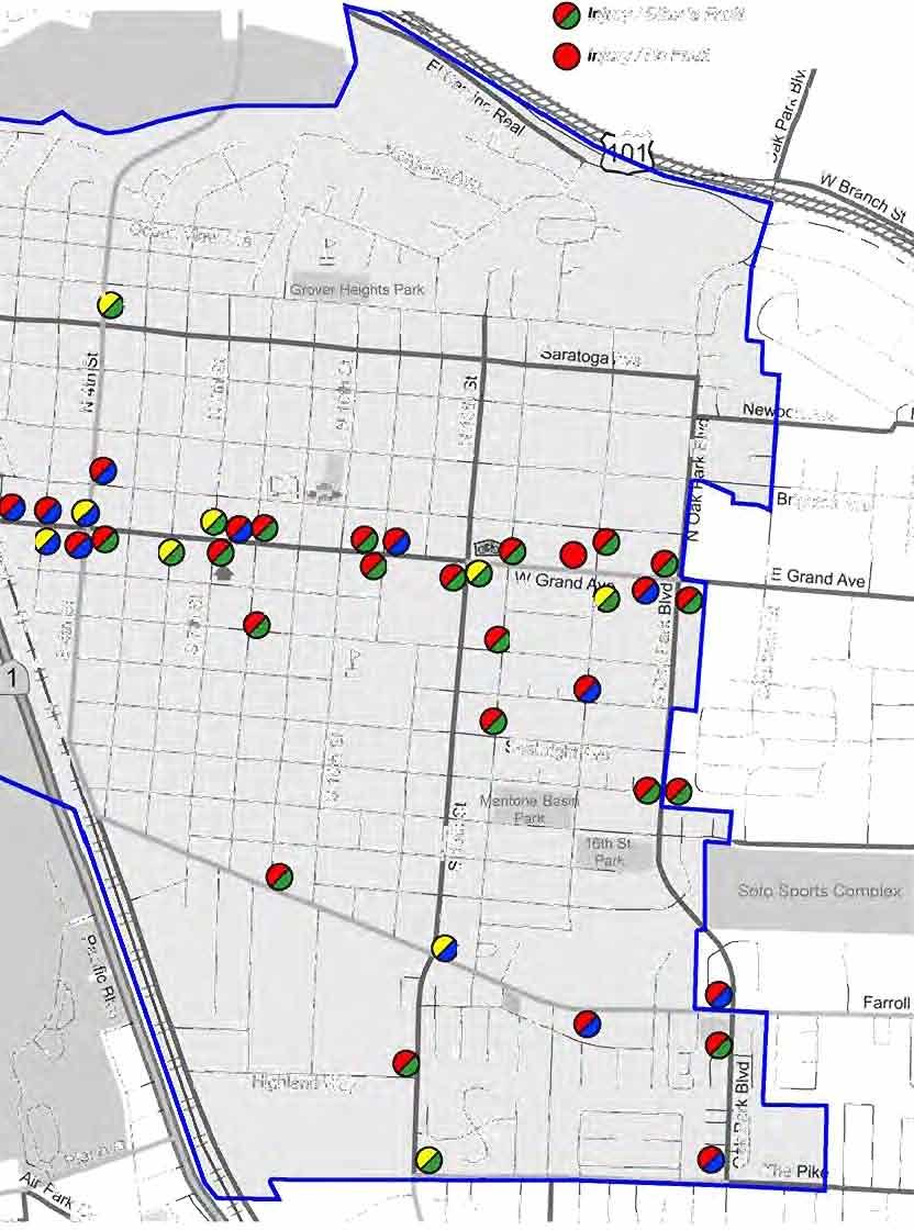
19 Neighborhood, community, and convenience shopping centers or freestanding commercial uses: 5% of vehicle requirement Offices: 7.5% of vehicle requirement Industrial uses: 7.5% of vehicle requirement A review of city parks and major businesses indicates provision for bike parking (racks) are not always present or limited in number of bikes that can be parked (Figure 3). 2.6 EXISTING BICYCLE TRANSPORT AND PARKING FACILITIES FOR CONNECTION WITH OTHER TRANSPORTATION MODES Bicycle transport and parking facilities do not exist at the train depot. The regional bus system has bicycle racks available on all buses in the South County for transport of bicycles. Bicycle racks and a small bicycle locker exist at the Ramona transit center on Ramona Avenue near 9 th Street. Other bicycle lockers are at the Rideshare Park and Ride facility at Halcyon Road and US 101 in Arroyo Grande. 2.7 EXISTING FACILITIES FOR CHANGING / STORING CLOTHES AND EQUIPMENT During the development review process, the City looks at ways to minimize impacts to traffic and air quality by requiring measures that allow people to ride to work. The Air Pollution Control District provides recommended measures to be applied to project conditions of approval that would reduce auto dependency. For commercial projects anticipated to have a large number of employees, one of these measures may be to include bike commuter facilities for changing clothes and storing clothes and equipment. However, the City does not keep and inventory of these types of facilities. Figure 6 identifies locations were these facilities may be desirable. 2.8 BICYCLE INCIDENT ANALYSIS Figure 5-Bicycle Accidents shows the distribution and type of bicycle related traffic accidents from April 2007 to April 2010 from City police records. There were 43 reported incidents with 10 incidents 15
20 resulting in property damage and 33 involving injury and / or hit and run. Fault was assigned to bicyclists in the majority of cases. The distribution of accidents cluster along Grand Avenue and the first blocks north and south of West Grand Avenue, Oak Park Boulevard, 13 th Street and 16 th Street. The accident rate is about 11 per year and an average of incident per 1,000 population. 2.9 EXISTING EDUCATION AND OUTREACH Existing education and outreach programs available in the San Luis Obispo region include the following: Safe Routes to School: SLO Regional Rideshare ( works with schools to offer individualized programs including Parent Surveys, Mini Grants given to promote cycling in the community, Bike Assemblies (a ride of recreational cycling in large groups ending with a presentation of bicycle education), and Bike Rodeo, a bicycle safety training and education for elementary school children. Employee Incentive Programs: SLO Regional Rideshare offers an employer Transportation Choices Program that helps employers promote bicycling, walking, carpooling, and riding the bus to work to reduce the employers need for car parking spaces. This program may provide financial incentives or only promotional materials. Bike Valet: Bike Valet is a service that is offered by the San Luis Obispo County Bicycle Coalition (SLOCBC). This service is usually for large city events to reduce car use and encourage bike travel. Bicycle Confidence Workshop: These workshops are a series of classes offered by the SLO Bike Coalition to teach adults safe bicycle riding; a fee is required for the class. 16


21


22


23
24 3.0 Bicycle Master Plan 3.1 GOALS, POLICIES AND IMPLEMENTATION MEASURES The following Goals, Policies and Implementation Measures, and the Bikeway Master Plan Exhibit (Figure 6), provide the City with specific measures for improving the bicycle facilities within the city limits. Unless otherwise identified, it is assumed that Community Development and Public Works Department staff will be responsible to establish or undertake specific implementation measures. It should also be noted that the policies identified in this document are not organized in any particular order of priority. The City should review the Bicycle Master Plan document periodically as to the priority of implementation based on feasibility to implement and available funding Bikeway Route Development Goal 1: A comprehensive network of bicycle and trail facilities that connect residential neighborhoods to commercial areas, parks and schools. Goal 2: A safe, convenient and connected bikeway system that meets the transportation and recreational needs of riders of all skill levels and complements other transportation types including automobiles, transit, trains and pedestrians. Goal 3: Provide a balanced transportation system consistent with the General Plan Circulation Element that provides residents a variety of transportation choices including automobile, transit, bicycle, and pedestrian options. 20
25 Policies 1. Provide a range of bikeway types, including bike lanes on arterial streets, bike lanes on selected collector streets, bike routes on selected low volume/low speed streets and off-street bike paths. 2. Provide convenient connections between residential areas, schools, parks, public transit stops, shopping centers, employment centers and other destinations. 3. Work cooperatively with neighboring jurisdictions to pursue connections to neighboring jurisdictions to ensure regional bicycle accessibility. Coordinate with Pismo Beach, Arroyo Grande and the County to ensure bicycle lane striping and signage connects seamlessly at city limits on Grand Avenue, Oak Park Boulevard, 4 th Street, Mentone / Ash Street, Farroll Road, the Pike (south side improvements) and Highway Work with neighboring cities to identify opportunities for development of a Beach Cities Multi-Use Trail in the Beach / Highway 1 corridor. 5. Promote land use development that enhances connectivity for transportation and recreation use, and lessens the distance of bicycle and pedestrian travel between uses. 6. Designate Class III on-street bike routes to provide connections between or to Class I and Class II bikeways in situations where there is not adequate street width or right-of-way, or as an interim facility until the street can be widened to accommodate a Class II bike lane., 7. Where a bikeway designation transitions from a Class II bike lane to Class III bike route, signs shall be installed to inform motorists that bicycles will be sharing the road. 8. Locate bicycle crossings at appropriate intervals 21
26 along City roadways as determined by the City Engineer. Work with Caltrans to provide safe and, convenient crossings of State highways and freeways at regular intervals. 9. Provide bicycle signal detectors per local and state law (AB 1581) at new or significantly modified signalized intersections with bike lanes and, if feasible, retrofit existing traffic signals so that bike detection is provided. 10. Evaluate signal timing at intersections that do not allow sufficient time for cyclists to clear the intersection. 11. Provide continuity in the design and consistent construction of bikeway facilities. 12. Work with Union Pacific Railroad Company (UPRR) and the California Public Utilities Commission (CPUC) to plan and construct safe and convenient crossings of the UPRR railroad tracks and right-ofway. Implementation Measures 1. Bikeway construction projects shall conform to the City Construction Standards, and state and federal standards. 2. City and private development projects shall be reviewed for conformance with the goals, policies and implementation measures of the Bicycle Master Plan. 3. The Public Works Department shall work with other departments to create a checklist for the evaluation of development projects for conformity to the Bicycle Master Plan. 4. The City shall consider participating in regional bicycle and pedestrian planning activities. 5. The City shall coordinate bikeway system projects internally and with adjacent jurisdictions, where appropriate. 22
27 6. The City shall provide training for appropriate staff, commissions and committees on the guiding principles of bicycle and pedestrian system transportation planning, design and maintenance Bikeway support facilities Goal: A comprehensive bikeway system with adequate support facilities to serve the needs of commuter and recreational bicycle riding. Policies 1. Provide support facilities such as trailhead parking lots, route map displays, rest areas/benches, drinking water, and bike racks along bike routes. Support facilities may be provided with parks and other public facilities or provided separately. 2. Conveniently locate bike racks and other short-term parking facilities at city parks and recreational facilities, state parks, schools and educational institutions, the train depot and business entrances. 3. Provide safe, secure and covered long-term bike parking (bike lockers, bike rooms, bike cages) at city parks and recreational facilities, employment sites and Park and Ride facilities. 4. Encourage major employment centers and commercial uses to provide amenities such as showers and changing facilities onsite for employees that bicycle to work or while at work. Implementation Measures 1. The City shall consider updating the Municipal Code (Zoning Ordinance) to include additional requirements for bike facilities as detailed in measures following. 2. The City shall develop standards for bicycle parking 23
28 in the public realm of Downtown Core and other pedestrian activity areas. 3. The City shall adopt guidelines for and encourage the installation of showers and changing facilities for employees at major employment sites. 4. The City shall consider partnerships with public and private facilities for use of showers and changing rooms by commuting or touring bicyclists. 5. Designated bike routes shall include signs informing motorists of the presence of bicyclists and information signs informing cyclists of upcoming destinations in accordance with California Manual of Uniform Traffic Devices and the City Standards. 6. The City shall provide destination signs, trail maps, mile markers, open space and bikeway regulation signs on bike paths where appropriate. 7. Require development projects (private and public) to install amenities such as bicycle racks, lockers and showers as a condition of approval Maintenance Goal: Provide well maintained bikeways and support facilities to ensure preservation of the public capital improvements and to provide safe and convenient facilities for cyclists and other trail users. Policies 1. Sweep all streets with Class II or III designation at regular time intervals. 2. Develop guidelines for routine maintenance and long-term maintenance of Class I (off-street) bike paths. 3. Review street maintenance overlay projects and other construction projects within the public right-ofway and along designated bikeways for conformance 24
29 with the Bicycle Master Plan. Where facilities are not in conformance with the Bicycle Master Plan and current City standards, the facilities may be brought up to standards where determined feasible. 4. Require construction projects that damage existing bicycle facilities to restore those facilities to preconstruction condition at developer/contractor expense. 5. Construction projects within public right-of-way should address bicycle safety and movement per Federal, State and Local standards. 6. Require developers/contractors to maintain clear and clean paths of travel for cyclists when construction operations occur adjacent to Class II and III bikeways. Implementation Measures 1. The City shall inspect bikeways and support facilities on a regular basis. 2. The City shall seek funding from new development projects for bikeway maintenance. 3. The City shall work cooperatively with local bicycle groups, neighborhood associations, and businesses to establish a bikeways maintenance program that address litter cleanup, pet waste cleanup, and as appropriate other bike path and open space maintenance activities. 4. The City shall update the Construction Standards to include standard provisions for Traffic Control Plans per the following: Construction signs should be placed outside bike lanes where feasible; Where a bike lane will be closed for an extended period, advance warning signs may be provided for bicyclists Enforcement 25
30 Goal: Provide a functional enforcement programs to increase bicycle safety and reduce violations and bicycle injuries. Policies 1. Strictly enforce bicycle safety laws focused on helmets for children and adults, failure to stop/yield, wrong way bike riding, and night riding without lights/reflectors. 2. Strictly enforce the California Vehicle Code and local laws relating to motorist failure to yield or stop for cyclists, excessive motor vehicle speed, and driving under the influence. Implementation Measures 1. The Police Department shall be involved in periodic review of the accident and safety aspects of the updates to the Bicycle Master Plan Education Goal 1: Increase bike rider and motorist awareness of the rights and responsibilities of bike riders in order to create a climate of acceptance for bike riding, reduce bike rider violations, improve safe bicycling and driving practices, reduce collisions, and increase bicycle riding to work, school, and other destinations. Goal 2: Increase awareness of users of multi-use paths of the rights and responsibilities of the various users. Policies 1. Provide education programs targeted to adults and children that explain safe bike riding techniques and the importance of proper helmet use, and provide information on the city bikeway system and support facilities. 2. Provide education programs targeted to school-age 26
31 children that acknowledge and recognize the unique challenges associated with child and youth bike riders. 3. Raise motorist awareness of the rights of bicyclists to ride on the road, and provide motorists information on ways they can modify their driving behavior to more safely accommodate bicyclists. Implementation Measures 1. The City shall work with Regional Rideshare and the San Luis Obispo County Bicycle Coalition to encourage promotional and educational activities within the community. 2. The City shall work with Lucia Mar Unified School District to identify potential bicycle education programs in schools, and to promote Safe Routes to School programs. 3. The City shall consider implementing a citywide helmet promotion program. 4. The City shall develop education materials (e.g. handouts, videos) for presentation to media, schools, neighborhood groups, businesses and other groups that promote bicycle safety. 5. The City shall develop criteria and promote trail etiquette for use of off-street bike paths by bicyclists, pedestrians, equestrians (if applicable), skaters, and persons with disabilities. 6. The City shall coordinate education and encouragement efforts with public health agencies, schools, and/or other social organizations Encouragement Goal: Increase transportation and recreation bicycle riding to work, school, play and other destinations by 50 percent by 2020, and gain acceptance of bicycle commuting as a mainstream activity. Policies 27
32 1. Encourage cycling and walking through a variety of programs and coalitions with local businesses, schools, clubs, bike shops and organizations. 2. Explore methods to provide incentives to individuals or businesses commuting to work by bicycle or walking. 4. Support recreational bikeway facilities, programs and events as an important part of the effort to cultivate acceptance of bicycling among the general populace. Implementation Measures 1. Continue to support regional efforts to promote biking such as May Is Bike Month, and International Walk/Bike to School day. 2. Enhance incentives for bicycle commuting such as May Is Bike Month. 3. Sponsor, in association with local bicycle organizations, bicycle parking at special events. 4. Sponsor, in association with local /regional bicycle organizations or other groups, bicycle/ triathlon events and races, or other similar events. 5. Support efforts of local bicycle groups to establish a bicycle station that delivers bicycle parking, showers, restrooms, bicycle services Environmental Goal 1: Reduce traffic, improve air quality, and reduce emissions that contribute to climate change by providing a viable commute alternative to the automobile. Goal 2: Enhance public access to open space and natural areas while minimizing the environmental 28
33 impacts. Policies 1. Promote the beneficial aspects of bicycling with the use of established bicycle promotional programs such as May is Bike Month. 2. Work collaboratively with other jurisdictions to provide bike/trail projects in the Five Cities Area and the region., 3. Provide informational signage along Class I Bike Paths and trails located within or adjacent to open space areas such as Meadow Creek and Pismo Lakes. Plan for signage that includes interpretive signs informing the public of the environmental resources present and directing users to behave in a manner that reduces impacts on the open space. 4. Comply with applicable Local, State and Federal environmental regulations. 5. Provide Class I Bike Paths and trails that have minimal effects on the environment and natural resources. Implementation Measures 1. The City will coordinate with local, state and federal agencies on the planning, environmental review, design, construction and maintenance of bike or trail projects located within or in proximity to sensitive environmental areas such as creeks and estuaries. 2. The City will partner with health organizations, where appropriate, to promote bicycling and healthy communities Funding Goal: Secure adequate funding for construction and maintenance of bikeways and support facilities, and education, encouragement, enforcement and evaluation programs. 29
34 Policies 1. Create a bikeway system that is cost effective to construct and maintain. 2. Maximize funding opportunities through a combination of federal, state and local sources, including development agreements, community facilities districts and grants. 3. Utilize grant funds to leverage local bikeway funds. 4. Where feasible and appropriate, include bike lane improvements consistent with the Design/Construction Standards as part of Capital Improvement Program projects. 5. Where appropriate, partner bike path projects with flood control, redevelopment, utilities access, air quality improvement and open space/ stream restoration projects. 6. Where bikeway projects cross jurisdictional boundaries, partner with adjacent jurisdictions as feasible to reduce costs. 7. Consider establishing development impact fees that can be used to improve bike facilities. Implementation Measures 1. Submit grant applications in accordance with the City s guidelines as grant programs become available. 2. Coordinate bikeway projects internally and with other agencies to determine partnering potential. 3. Continue to require new development to improve bike facilities within their project and / or as part of roadway improvements associated with a project. 30
35 3.1.9 Evaluation Goal: Evaluate the effectiveness of the City s bicycle programs and the efforts to implement the overarching bikeway goals of the General Plan and the Bicycle Master Plan on an on-going basis. Policies 1. Establish and implement a plan for regular measurement of the amount of cycling taking place in the City. 2. Annually review bicycle collision data to identify commonalities and trends and identify engineering, maintenance, enforcement, education and encouragement efforts to reduce collisions and injuries. Implementation Measures 1. The City shall prepare an annual report summarizing the bicycle program and collision data, and identify a work plan to address any concerns in the report. 3.2 PROPOSED BIKEWAY MASTER PLAN The proposed Bikeway Master Plan System (Figure 6) and Bikeway Mater Plan Implementation (Figure 7) illustrate the network of bikeways intended to serve the City and provide improved bikeway conditions for those biking through the region. Section 4.2 and Table A list the bicycle improvement projects and priorities. Bikeways are listed by Class I, II or III, and are defined as follows: Class I Bikeway (Bike Path) - Provides completely separated path for the exclusive use of bicycles and pedestrians with crossflow minimized. Class II Bikeway (Bike Lane) - Provides a striped lane for oneway bike travel on a street or highway. 31
36 Class III Bike Route, Level A - Provides shared use with motor vehicle traffic, is identified by Bike Route signs. These routes are intended to have a minimum amount of paving (at least 2-ft) beyond the travel lane to provide more room for bicyclists. Class III Bike Route, Level B - Unsigned bike routes that provides Share the Road only signage on roads that are very narrow, winding, or difficult to widen due to physical /environmental constraints. 32


37


38
39 4.0 Prioritization Strategy 4.1 PAST EXPENDITURES From 2005 through 2009 the City has installed bicycle lane striping on six road segments as part of street improvement projects. The expenditure over this period was $29,639. The street segments striped include: West Grand Avenue Enhancement, 2 nd Street to 4th Street S. 4th Street, Seabright to West Grand Avenue S. 13th Street, West Grand Ave to Manhattan N. 4th Street, Ocean View Ave to City Limits N. 4th Street, West Grand Avenue to Ocean View Avenue Meadow Creek Bridge and Storm Drain Project In addition, the City expended $61,649 for the Longbranch Aveeue Demonstration Project study and $40,594 for the Beach Cities Multi- Purpose Trail Feasibility Study. 4.2 PROPOSED FACILITY IMPROVEMENTS, COST AND PRIORITIES Table A summarizes the proposed bicycle facility improvements, grouped by general priority, with an estimated cost in 2010 dollars. The priorities should be re-evaluated periodically by the City based on changing needs and fund availability. 35
40 Bike Master Plan Table A Improvement Projects, Priorities and Cost Priority Facility Project Length Cost 2 Notes type Oak Park Blvd- US 101 to Saratoga: 1,637 lf $3,421 renew stripe 1 2 Oak Park Blvd- Mentone to Farroll: 1,742 lf $3,641 renew stripe 3 3 Oak Park Blvd- signage - $5, W. Grand Ave- Oak Park to 11 th : 2,587 lf $12,392 stripe and legend 2 2 W. Grand Ave- 8 th to beach: 3,960 lf $18,968 stripe and legend 2 2 Atlantic City Ave- 4 th to Oak Park 5,174 lf $24, Saratoga Ave- 13 th St to Oak Park 1,848 lf $8, Newport Ave- 4 th St to Oak Park Blvd 5,174 $24, Mentone Ave- Oak Park to 4 th : Stripe and legend 2 2 Longbranch Ave- Oak Park to 4 th : Stripe and legend th Street-Atlantic City to the Pike: stripe and legend 1 2 El Camino Real- 101 interchange west to City limit: Renew stripe 2 2 El Camino Real- 101 interchange east to City limit: Stripe and legend 2 2 Atlantic City- 4 th to Front St: stripe and legend th Street-Trouville to south City limit: Stripe and legend 4,435 $21,244 4,435 lf $21, th to 16 th class 3 route 7,550 lf $36,164 Segments will 2,745 lf $5,738 1,478 lf $7,081 need full street width to implement 1,584 lf $7,587 Segments will need full street width to implement 4,382 lf $20,991 Segments will need full street width to implement 2 2 The Pike/Highland Way- 13 th to S. 4 th : stripe 1,584 lf $7,587 Install with planned new street th Street-Atlantic City to ECR: class 3 $1,000 signage 4 4 Bike rack and locker at Train Depot $10, Bike rack program for parks $10, Bike locker facilities at employment centers 3 $50,000 36
41 Bike Master Plan Table A Improvement Projects, Priorities and Cost 4 1 Beach Cities Multi Use Trail-option D 3 TBD 4 1 Beach Cities Multi Use Trail-option A TBD South of Grand to City limit segment 4 1 Beach Cities Multi Use Trail-option A TBD 4 th Street to ECR segment 4 1 Beach Cities Multi Use Trail-option B TBD South of Grand to City Limit 4 1 Beach Cities Multi Use Trail-option E TBD 4 1 Beach Cities Multi Use Trail-option F TBD 4 4 Beach Cities Multi-Use Trail- UPRR bike / ped overpass bridge TBD TBD indicates To be determined Footnotes 1. Facility Types are: 1= Class 1 path, 2= Class 2 lane, 3= Class 3 route, 4= other facility 2. Based on recent City bid, the cost per block (370 linear feet) for a Class 2 lane is $1,775 ($4.79 / lf) and includes bike lane signs (4), bike lane symbol, 6 inch strip, 10% contingency and all design and management costs. Stripe and symbol renewal only is calculated at $775 per block or $2.09 / lf. 37
42 5.0 Funding Opportunities There are a variety of potential funding sources that can be used for bicycle projects, programs and plans from all levels of government. This section covers federal, state, regional and local sources of funding, as well as some non- traditional funding sources that may be used for bicycle projects. 5.1 FEDERAL FUNDING SOURCES The primary federal source of surface transportation funding, including bicycle and pedestrian facilities, is the Safe, Accountable, Flexible, Efficient, Transportation Equity Act: A Legacy for Users. This Federal bill was established by Congress in 1991 with the Intermodal Surface Transportation Efficiency Act, and renewed in 1998 and extended in 2003 through the Transportation Equity Act for the 21st Century and the Safe, Accountable, Flexible, and Efficient Transportation Equity Act of Also known as the Federal Transportation Bill, it was passed in 2005 and authorizes federal surface transportation programs for the five-year period. In late September 2009, as the 2005 federal transportation bill (SAFETEA-LU) was set to expire, a debate emerged in Congress regarding the length of time to extend the current bill while new policy is created. Rather than a simple reauthorization of existing policy, a new bill is being crafted with new policies and funding formulas, in recognition of the urgency of national needs -- obesity prevention, escalating fuel prices, the need for energy independence from Middle East oil, and perhaps most important, the battle against global climate change. In December 2009 Congress voted to extend the current bill until September Federal funding is administered through the state (Caltrans and the State Resources Agency) and regional planning agencies. Most, but not all, of these funding programs are oriented toward transportation 38
43 versus recreation, with an emphasis on reducing auto trips and providing inter-modal connections. Many Federal programs require a local match of between 10-20%. Federal funding is intended for capital improvements and safety and education programs and projects must relate to the surface transportation system. Federal Lands Highway Funds Federal Lands Highway Funds may be used to build bicycle and pedestrian facilities in conjunction with roads and parkways at the discretion of the department charged with administration of the funds. The projects must be transportation-related and tied to a plan adopted by the State and Metropolitan Planning Organization. Federal Lands Highway Funds may be used for planning and construction and is managed by the United States Department of Transportation. Transportation, Community and System Preservation Program The Transportation, Community and System Preservation Program provides federal funding for transit oriented development, traffic calming and other projects that improve the efficiency of the transportation system, reduce the impact on the environment, and provide efficient access to jobs, services and trade centers. The program is intended to provide communities with the resources to explore the integration of their transportation system with community preservation and environmental activities. The Program funds require a 20% match and can be applied to planning, design and construction and is administered through the Federal Highway Administration. Land and Water Conservation Fund The Land and Water Conservation Fund is a federally funded program that provides grants for planning and acquiring outdoor recreation areas and facilities. The Fund is administered by the National Parks Service and the California Department of Parks and Recreation and has been reauthorized until Cities, counties and districts authorized to acquire, develop, operate and maintain park and recreation facilities are eligible to apply. The application deadline is in May, and applicants must fund the entire project, and will be reimbursed for 50% of costs. Property acquired or developed under the program must be retained in perpetuity for public recreational use. 39
44 Congestion Mitigation and Air Quality Improvement Program (CMAQ) CMAQ Funds are directed to transportation projects and programs which contribute to the attainment or maintenance of National Ambient Air Quality Standards in non-attainment or air quality maintenance areas for ozone, carbon monoxide, or particulate matter under provisions in the Federal Clean Air Act. Eligible projects include bicycle facilities. Highway Safety Improvement Program (HSIP) The Highway Safety Improvement Program is managed locally by Caltrans. For a project to be eligible for HSIP funds, the project must be on any public road, publicly owned bicycle, pedestrian pathway, or trail. Projects must identify a specific safety problem that can be corrected or be improved substantially. Regional Surface Transportation Program (RSTP) Regional Surface Transportation Program (RSTP) funding is distributed based on population, among the urbanized and nonurbanized areas of the State through Metropolitan Planning Organizations (MPOs) and Regional Transportation Planning Agencies (RTPAs). Bicycle facilities are eligible for funding through this federally administered program. Safe Routes to School (SRTS) Eligible projects fall under the category of infrastructure (capital improvements), or non-infrastructure (education, encouragement, enforcement). Infrastructure projects must be located within a two mile radius of a grade school or middle school. Local Caltrans representatives serve as the administrative authority on SRTS projects. Transportation Enhancements (TE) Federal Transportation Enhancement funds are to be used for transportation- related capital improvement projects that enhance quality-of-life, in or around transportation facilities. Facilities that qualify for TE funds include bicycle safety, education and facility projects. Transportation Enhancements projects are managed locally by Caltrans. 40
45 5.2 STATEWIDE FUNDING SOURCES Bicycle Transportation Account The Bicycle Transportation Account provides state funding for local projects that improve the safety and convenience of bicycling for transportation. Because of its focus on transportation, Bicycle Transportation Account projects must provide a demonstrable level of utility for transportation purposes. For example, all in-town onstreet and paved bikeways would be good candidates for funding. Funds are available for both planning and construction. Bicycle Transportation Account funding is administered by Caltrans and cities and counties must have an adopted Bicycle Transportation Plan in order to be eligible. The maximum amount available through the Bicycle Transportation Account is $1.2 million dollars, cities and counties are eligible to apply. All projects must be designed to the standards outlined in Chapter 1000 of the Highway Design Manual. The application deadline is in December. Community Based Transportation Planning Demonstration Grant Program This fund, administered by Caltrans, provides funding for projects that exemplify livable community concepts including bicycle improvement projects. Eligible applicants include local governments, metropolitan planning organizations and regional transportation planning agencies. A 20% local match is required and projects must demonstrate a transportation component or objective. There is $3 million available annually statewide. The application deadline is in October. Safe Routes to School (SR2S) To be eligible for SR2S funds, the project must be located on any state highway or on any local road. Projects must correct an identified safety hazard or problem on a route that students use for trips to and from school. Up to 10 percent of the project s cost can fund a non infrastructure component that supports the infrastructure project. Only cities and counties are eligible to compete for funds. State Transportation Improvement Program (STIP) All STIP projects must be capital projects (including project development costs) needed to improve transportation. Eligible projects include bicycle facility improvements and improved access to transit and are administered by Caltrans. 41
46 Transportation Development Act Transportation Development Act Article 3 funds are state block grants awarded monthly to local jurisdictions for transit, bicycle and pedestrian projects in California by Caltrans. Funds for pedestrian projects originate from the Local Transportation Fund, which is derived from a ¼ cent of the general state sales tax. Local Transportation Funds are returned to each county based on sales tax revenues. Article 3 of the Transportation Development Act sets aside 2% of the Local Transportation Funds for bicycle and pedestrian projects. Eligible pedestrian and bicycle projects include: construction and engineering for capital projects; maintenance of bikeways; bicycle safety education programs (up to 5% of funds); and development of comprehensive bicycle or pedestrian facilities plans. A city may use these funds to update their bicycle and pedestrian plan not more than once every five years. These funds may be used to meet local match requirements for federal funding sources. Application deadlines vary within county transportation agencies. 5.3 LOCAL AND REGIONAL FUNDING SOURCES Developer Impact Fees Traffic Impact Fees placed on new development typically cover the ultimate build-out of roadways associated with project improvements. The fees are reviewed and updated by the City periodically to reflect current economic conditions and costs to improve. 5.4 NON-TRADITIONAL FUNDING SOURCES The Community Development Block Grant program provides money for streetscape revitalization, which may be largely comprised of pedestrian improvements. Federal Community Development Block Grant grantees may use [these] funds for activities that include (but are not limited to): acquiring real property; reconstructing or rehabilitating housing and other property; building public facilities and improvements, such as streets, sidewalks, community and senior citizen centers and recreational facilities, paying for planning and administrative expenses, such as costs related to developing a consolidated plan and managing Community Development Block Grant funds; provide public services for youths, seniors, or the disabled; and initiatives such as neighborhood watch programs. 42
47 Appendix A State Highway Code Full text of Streets and Highways code, Section It is the intent of the Legislature, in enacting this article, to establish a bicycle transportation system. It is the further intent of the Legislature that this transportation system shall be designed and developed to achieve the functional commuting needs of the employee, student, business person, and shopper as the foremost consideration in route selection, to have the physical safety of the bicyclist and bicyclist's property as a major planning component, and to have the Town or county to accommodate bicyclists of all ages and skills As used in this chapter, "bicycle" means a device upon which any person may ride, propelled exclusively by human power through a belt, chain, or gears, and having either two or three wheels in a tandem or tricycle arrangement As used in this article, "bicycle commuter" means a person making a trip by bicycle primarily for transportation purposes, including, but not limited to, travel to work, school, shopping, or other destination that is a center of activity, and does not include a trip by bicycle primarily for physical exercise or recreation without such a destination As used in this article, "bikeway" means all facilities that provide primarily for bicycle travel. For purposes of this article, bikeways shall be categorized as follows: (a) Class I bikeways, such as a "bike path," which provide a completely separated right-of-way designated for the exclusive use of bicycles and pedestrians with cross flows by motorists minimized. (b) Class II bikeways, such as a "bike lane," which provide a restricted right-of-way designated for the exclusive or semi-exclusive use of bicycles with through travel by motor vehicles or pedestrians prohibited, but with vehicle parking and cross flows by pedestrians and motorists permitted. (c) Class III bikeways, such as an on-street or off-street "bike route," which provide a right-of-way designated by signs or permanent markings and shared with pedestrians or motorists The department, in cooperation with county and Town governments, shall establish minimum safety design criteria for the planning and construction of bikeways and roadways where bicycle travel is permitted. The criteria shall include, but not be limited to, the design speed of the facility, minimum widths and clearances, grade, radius of curvature, pavement surface, actuation of automatic traffic control devices, drainage, and general safety. The criteria 43
48 shall be updated biennially, or more often, as needed The department shall establish uniform specifications and symbols for signs, markers, and traffic control devices to designate bikeways, regulate traffic, improve safety and convenience for bicyclists, and alert pedestrians and motorists of the presence of bicyclists on bikeways and on roadways where bicycle travel is permitted All Town, county, regional, and other local agencies responsible for the development or operation of bikeways or roadways where bicycle travel is permitted shall utilize all minimum safety design criteria and uniform specifications and symbols for signs, markers, and traffic control devices established pursuant to Sections and A Town or county may prepare a bicycle transportation plan, which shall include, but not be limited to, the following elements: (a) The estimated number of existing bicycle commuters in the plan area and the estimated increase in the number of bicycle commuters resulting from implementation of the plan. (b) A map and description of existing and proposed land use and settlement patterns which shall include, but not be limited to, locations of residential neighborhoods, schools, shopping centers, public buildings, and major employment centers. (c) A map and description of existing and proposed bikeways. (d) A map and description of existing and proposed end-of-trip bicycle parking facilities. These shall include, but not be limited to, parking at schools, shopping centers, public buildings, and major employment centers. (e) A map and description of existing and proposed bicycle transport and parking facilities for connections with and use of other transportation modes. These shall include, but not be limited to, parking facilities at transit stops, rail and transit terminals, ferry docks and landings, park and ride lots, and provisions for transporting bicyclists and bicycles on transit or rail vehicles or ferry vessels. (f) A map and description of existing and proposed facilities for changing and storing clothes and equipment. These shall include, but not be limited to, locker, restroom, and shower facilities near bicycle parking facilities. (g) A description of bicycle safety and education programs conducted in the area included within the plan, efforts by the law enforcement agency having primary traffic law enforcement responsibility in the area to enforce provisions of the Vehicle Code pertaining to bicycle operation, and the resulting effect on accidents involving bicyclists. (h) A description of the extent of citizen and community involvement in development of the plan, including, but not limited to, letters of support. (i) A description of how the bicycle transportation plan has been coordinated and is consistent with other local or regional transportation, air quality, or energy conservation plans, including, but not limited to, programs that provide incentives for bicycle 44
49 commuting. (j) A description of the projects proposed in the plan and a listing of their priorities for implementation. (k) A description of past expenditures for bicycle facilities and future financial needs for projects that improve safety and convenience for bicycle commuters in the plan area (a) A Town or county that has prepared a bicycle transportation plan pursuant to Section may submit the plan to the county transportation commission or transportation planning agency for approval. The Town or county may submit an approved plan to the department in connection with an application for funds for bikeways and related facilities which will implement the plan. If the bicycle transportation plan is prepared, and the facilities are proposed to be constructed, by a local agency other than a Town or county, the Town or county may submit the plan for approval and apply for funds on behalf of that local agency. (b) The department may grant funds applied for pursuant to subdivision (a) on a matching basis which provides for the applicant's furnishing of funding for 10 percent of the total cost of constructing the proposed bikeways and related facilities. The funds may be used, where feasible, to apply for and match federal grants or loans The Sacramento Area Council of Governments, pursuant to subdivision (d) of Section 2551, may purchase, operate, and maintain call boxes on Class I bikeways The governing body of a Town, county, or local agency may do all of the following: (a) Establish bikeways. (b) Acquire, by gift, purchase, or condemnation, land, real property, easements, or rights-of-way to establish bikeways. (c) Establish bikeways pursuant to Section of the Vehicle Code (a) Rights-of-way established for other purposes by cities, counties, or local agencies shall not be abandoned unless the governing body determines that the rights-of-way or parts thereof are not useful as a non-motorized transportation facility. (b) No state highway right-of-way shall be abandoned until the department first consults with the local agencies having jurisdiction over the areas concerned to determine whether the right-of-way or part thereof could be developed as a non-motorized transportation facility. If an affirmative determination is made, before abandoning the right-of-way, the department shall first make the property available to local agencies for development as non-motorized transportation facilities in accordance with Sections and of this code and Section of the Government Code (a) The Bicycle Transportation Account is continued in existence in the State Transportation Fund, and, notwithstanding Section of the Government Code, the money in the account is continuously appropriated to the department for expenditure for the purposes specified in Section Unexpended moneys shall be 45
50 retained in the account for use in subsequent fiscal years. (b) Any reference in law or regulation to the Bicycle Lane Account is a reference to the Bicycle Transportation Account The department shall allocate and disburse moneys from the Bicycle Transportation Account according to the following priorities: (a) To the department, the amounts necessary to administer this article, not to exceed 1 percent of the funds expended per year. (b) To counties and cities, for bikeways and related facilities, planning, safety and education, in accordance with Section The Bikeway Account, created in the State Transportation Fund by Chapter 1235 of the Statutes of 1975, is continued in effect, and, notwithstanding Section of the Government Code, money in the account is hereby continuously appropriated to the department for expenditure for the purposes specified in this chapter. Unexpended money shall be retained in the account for use in subsequent fiscal years The Legislature finds and declares that the construction of bikeways pursuant to this article constitutes a highway purpose under Article XIX of the California Constitution and justifies the expenditure of highway funds therefore The department shall disburse the money from the Bicycle Transportation Account pursuant to Section for projects that improve the safety and convenience of bicycle commuters, including, but not limited to, any of the following: (a) New bikeways serving major transportation corridors. (b) New bikeways removing travel barriers to potential bicycle commuters. (c) Secure bicycle parking at employment centers, park-and-ride lots, rail and transit terminals, and ferry docks and landings. (d) Bicycle-carrying facilities on public transit vehicles. (e) Installation of traffic control devices to improve the safety and efficiency of bicycle travel. (f) Elimination of hazardous conditions on existing bikeways. (g) Planning. (h) Improvement and maintenance of bikeways. In recommending projects to be funded, due consideration shall be given to the relative cost effectiveness of proposed projects The department shall not finance projects with the money in accounts continued in existence pursuant to this article which could be financed appropriately pursuant to Article 2 (commencing with Section 887), or fully financed with federal financial assistance If available funds are insufficient to finance completely any project whose eligibility is established pursuant to Section 893, the project shall retain its priority for allocations in subsequent fiscal years The department shall make a reasonable effort to disburse funds in general proportion to population. However, no applicant 46
51 shall receive more than 25 percent of the total amounts transferred to the Bicycle Transportation Account in a single fiscal year The department may enter into an agreement with any Town or county concerning the handling and accounting of the money disbursed pursuant to this article, including, but not limited to, procedures to permit prompt payment for the work accomplished The department, in cooperation with county and Town governments, shall adopt the necessary guidelines for implementing this article. 47
52 Appendix B Design Guidelines 48
53 Bicycle Facility Design Guidelines DESIGN GUIDELINES This section provides basic bikeway planning and design guidelines for use in developing bikeway system and support facilities. Where noted, designs are for elements required by the State of California for compliance with Caltrans Highway Design Manual Chapter 1000 Bikeway Planning and Design guidelines. Otherwise, these guidelines include additional recommendations, providing information on optional design treatments. Although this information meets Caltrans requirements it is not intended to state a minimum or maximum accommodation or to replace any existing adopted roadway design guidelines. Also included in this Chapter, are experimental or nonstandard best practices with information about optional innovative bikeways and support facilities that have not been adopted by the Manual of Uniform Traffic Control Devices (MUTCD) or State of California for use in California and do not meet Caltrans Chapter 1000 design requirements. All facility designs are subject to Public Works engineering design review and approval. Bikeway Facility Classifications According to Caltrans, the term bikeway encompasses all facilities that provide primarily for bicycle travel. Caltrans has defined three types of bikeways in Chapter 1000 of the Highway Design Manual: Class I, Class II, and Class III. For each type of bikeway facility both Design Requirements and Additional Design Recommendations are provided. Design Requirements contain requirements established by Caltrans Chapter 1000 Bikeway Planning and Design. Additional Design Recommendations are provided as guidelines to assist with design and implementation of facilities and include alternate treatments approved or recommended but not required by Caltrans. Class I Bikeway Design Typically called a bike path or shared use path, a Class I bikeway provides bicycle travel on a paved right-of-way completely separated from any street or highway. The recommended width of a shared use path is dependent upon anticipated usage: 8 feet (2.4 m) is the minimum width for Class I facilities 8 feet (2.4 m) may be used for short neighborhood connector paths (generally less than one mile in length) due to low anticipated volumes of use 10 feet (3.0 m) is the recommended minimum width for a typical two-way bicycle path
54 Bicycle Facility Design Guidelines 12 feet (3.6 m) is the preferred minimum width if more than 300 users per peak hour are anticipated, and/or if there is heavy mixed bicycle and pedestrian use a minimum 2 feet (0.6 m) wide graded area must be provided adjacent to the path to provide clearance from trees, poles, walls, guardrails, etc. On facilities with expected heavy use, a yellow centerline stripe is recommended to separate travel in opposite directions. Class I Bikeway Crossing Designs At Grade Intersection When shared-use paths cross streets, proper design should be developed on the pathway as well as on the roadway to alert bicyclists and motorists of the crossing. Sometimes on larger streets, at midblock pathway crossing locations

55 Bicycle Facility Design Guidelines an actuated signal is necessary. A signal allows bicyclists a clear crossing of a multi-lane roadway. If a signal is or is not needed, appropriate signage and pavement markings should be installed, including stop signs and bike crossing pavement markings. Overcrossings Overcrossings are also an important component of bikeway design. Barriers to bicycling often include freeways, complex interchanges, and rivers. When a route is not available to cross these barriers a bicycle overcrossing is necessary. Some design considerations for overcrossings include: Pathways must be a minimum 6 feet wide, with a preferred width of 8 or 10 feet wide Slope of any ramps must comply with ADA Guidelines Screens are often a necessary buffer between vehicle traffic and the bicycle overcrossing 5%-100 5%-400 5%-300 5%-400 Class II Bikeway Design Often referred to as a bike lane, a Class II bikeway provides a striped and stenciled lane for one-way travel on either side of a street or highway. To provide bike lanes along corridors where insufficient space is currently available, extra room can be provided by removing a traffic lane, narrowing traffic lanes, or prohibiting parking. The width of the bike lanes vary according to parking and street conditions. Note that these dimensions are for reference only, may not meet City of Standards and are subject to engineering design review. 4 feet (1.2 m) minimum if no gutter exists, measured from edge of pavement 5 feet (1.5 m) minimum with normal gutter, measured from curb face; or 3' (0.9 m) measured from the gutter pan seam
 minimum for a shared bike/parking lane where parking is permitted but not marked on streets without curbs; or 12 feet (3.6 m) for a shared lane adjacent to a curb face.")

56 Bicycle Facility Design Guidelines 5 feet (1.5 m) minimum when parking stalls are marked 11 feet (3.3 m) minimum for a shared bike/parking lane where parking is permitted but not marked on streets without curbs; or 12 feet (3.6 m) for a shared lane adjacent to a curb face. Class II Intersection Design-Signalized Intersections Intersections represent a primary collision point for bicyclists. Small intersections with few lanes are relatively easy to manage. Large, multi-lane intersections are more difficult for bicyclists to travel through than smaller, two-lane intersections. Challenges and potential solutions for bicyclists at large signalized intersections include: Signals may not be timed to allow slower-moving bicyclists to travel across the intersection. Solution: Bicycle adaptive signal timing.
57 Bicycle Facility Design Guidelines Loop detectors or video detection that is used to actuate the signal may not be calibrated to detect bicyclists. Solution: Design standard of bike loop use. Bicyclists may not know how to actuate the signal using loop detectors, even if it is calibrated. Solution: Use of bike loop detector symbol. Bicyclists who are traveling straight may have to merge across motor vehicle traffic that is turning right from a right-turn lane. Solution: Bike lane pockets at intersections, between through and right turn lanes. Design treatments can help bicyclists travel through intersections and alert motorists of bicyclists presence. Good intersection design alerts motorist to bicyclists, indicates to motorists and bicyclists where bicyclists may ride, and guides bicyclists through intersections. This treatment provides a design for where a roadway with Class II bike lanes intersects with a road at a signalized intersection. Bicycle Actuated Signals & Adaptive Signal Timing Making intersections more friendly to bicyclists, involves modifying how they operate. Improved signal timing, calibrating loop detectors to detect bicyclists, and camera detection makes intersections easier for bicyclists to cross intersections. Loop detectors are installed within the roadway to allow the metal of a motor vehicle to trigger a change in the traffic signal. Many standard motor vehicle loop detectors can be calibrated to detect bicycles. This allows the bicyclist to stay within the lane of travel and avoid maneuvering to the side of the road to trigger a push button. Signals can be configured so that if a bicycle is detected, an extended green time can be provided. Signal Timing Cities often apply signal timing techniques to enhance bicycle travel along major streets. For instance, closely-spaced signals (e.g., along one-way streets in City areas) can be timed to match bicyclists travel speeds. Signals timed for speeds of 12 to 16 MPH enable most bicyclists to ride comfortably with traffic. Signal timing should also take into account the necessary time needed for a bicyclist to cross a wide intersection. Activation devices can also be used on a roadway approach to prolong the green phase and extend the time needed for a bicyclist to clear the intersection. Standards suggest


58 Bicycle Facility Design Guidelines intersections utilize markings to indicate the location where a bicyclist is to be positioned in order to actuate a signal. Adjacent signage is also recommended to emphasize the connection between the marking and the signal. Right-Turn Only Lanes Right-turn only lanes can present challenges for bicyclists traveling through an intersection. Bicyclists must merge to the left to position themselves in the through travel lane. Jurisdictions will sometimes stripe bike lanes on the rightside of right-turn only lanes, which places the through-cyclist in direct conflict with a right-turning vehicle. The appropriate treatment for right-turn only lanes is to either drop the bike lane entirely approaching the right-turn lane, or to place a bike lane pocket between the right-turn lane and the right-most through lane. Freeway Ramps Freeway on- and off-ramp crossings present a potential conflict zone for bicyclists and motorists, as bicycle lanes are typically dropped and bicyclists must merge across travel lanes where vehicles are accelerating or decelerating from freeway speeds. The appropriate bicyclist behavior is to merge left away so as to be positioned in the through lane well before the mouth of the on-ramp, and to remain out away from the curb until past the off-ramp. Implementation of interchange improvements requires coordination with Caltrans regarding placement of signage and striping because these areas are in Caltrans right-ofway. Three guidelines for these improvements are: The bicycle merge should begin 250 feet in advance of the freeway on-
59 Bicycle Facility Design Guidelines ramp. Appropriate signage and striping should be used to warn bicyclists and motorists of the merge. Bicycle improvements to freeway ramps At-Grade Railroad Crossings City of has at-grade railroad crossings for existing and proposed bikeways. If bicyclists do not ride at a 90 degree angle over the tracks, bicyclists wheels can catch in the tracks and potentially lead to a collision. Class III Bikeway Design Generally referred to as a bike route, a Class III bikeway provides routes through areas not served by Class I or II facilities or to connect discontinuous segments of a bikeway. Class III facilities can be shared with either motorists on roadways or pedestrians on a sidewalk (not advisable) and is identified only by signing. There are no recommended minimum widths for Class III facilities, but when encouraging bicyclists to travel along selected routes, traffic speed and volume, parking, traffic control devices, and surface quality should be acceptable for bicycle travel. Although it is not a requirement, a wide outside traffic lane (14 feet) is typically preferable to enable cars to safely pass bicyclists without crossing the centerline. Caltrans Chapter 1000 provides details regarding the design requirements for placement and spacing of bicycle route signage. On-Street Regulatory & Warning Bike Signs Signage for on-street bikeways includes standard BIKE LANE and BIKE ROUTE signage, as well as supplemental signage such as SHARE THE ROAD and warning signage for constrained bike lane conditions. Signage should be installed on existing signposts if possible, reducing visual clutter along the path or roadway. Shared Roadway Bicycle Marking Recently, Shared Lane Marking stencils have been introduced for use in California as an additional treatment for Class III facilities. The stencil can serve a number of purposes, such as making motorists aware of bicycles potentially in their lane, showing bicyclists the direction of travel, and, with proper placement, reminding bicyclists to bike further from parked cars to prevent dooring collisions.
60 Bicycle Facility Design Guidelines Bike Route Signage In addition to wayfinding signs, bike route network signage that uses the California Manual of Uniform Traffic Control Devices (CAMUTCD) standard should be used by local jurisdictions. Route numbering for these signs should be coordinated with neighboring jurisdictions where bikeways cross borders. Most commonly, they show the route number and the corresponding direction. For bike route signs, CAMUTCD requires a green background and white lettering. The top portion of the sign is customizable for the City or region where it is located. Multi-Use Path Signs Local jurisdictions should work together to create a sign system for the multiuse path network. It is an expanding network that could link with many destinations countywide. Signs could show destinations as well as proper traffic control. These signs could be coordinated with other on-street bicycle route signage. This system should encourage use of trails for recreational as well as functional bicycling trip-purposes. Helping bicyclists of all ages reach destinations easily. Wrong-Way Signs The local jurisdictions may want to consider additional signage on bikeways with high levels of wrong-way riding. The City of Sunnyvale, places wrong way riding signs on the back of bike lane signs to help prevent bicyclists using bicycle lanes in the wrong direction, riding against traffic. Parallel Path Warning Signage When paths are located parallel and adjacent to roadways, vehicles turning into and out of streets and driveways must cross the path. Conflicts between bicyclists and pedestrians and turning motorists are common at these types of intersections. Turning motor vehicles do not expect to see bicyclists or pedestrians coming in the opposite direction of traffic. Starting in the early 1990 s, the City of Denver, Colorado began using experimental warning signage at its parallel paths. The signage is modified from the standard MUTCD railroad warning signage. Experimental signage, similar to the Denver parallel path warning signs, could help alert motorists to the presence of bicyclists and pedestrians on parallel paths.

61 Bicycle Facility Design Guidelines Short Term Bicycle Parking Short term bicycle parking facilities are best used to accommodate visitors, customers, messengers and others expected to depart within two hours. Bicycle racks provide support for the bicycle but do not have locking mechanisms. Racks are relatively low-cost devices that typically hold between two and eight bicycles, allow bicyclists to securely lock their frames and wheels, are secured to the ground, and should be located in highly visible areas, preferably at the

62 Bicycle Facility Design Guidelines front of a building. They are usually located at schools, commercial locations, and activity centers such as parks, libraries, retail locations, and civic centers. Bike Rack Guidelines Bicycle racks should be installed in accordance to the Association of Pedestrian and Bicycle Professionals Bicycle Parking Guidelines ( page=publications) with the following guidelines in mind: The rack element (part of the rack that supports the bike) should keep the bike upright, supporting the frame in two places and allowing one or both wheels to be secured. Install racks so there is enough room between adjacent parked bicycles. If it becomes too difficult for a bicyclist to easily lock their bicycle, they may park elsewhere. A row of inverted U racks should be installed with 15 inches minimum between racks. Empty racks should not pose a tripping hazard for visually impaired pedestrians. Position racks out of the walkway s clear zone. When possible, racks should be in a covered area protected from the elements.

63 Bicycle Facility Design Guidelines Long-term parking should always be protected. Generally, U type racks bolted into the sidewalk are preferred and should be located intermittently or in front of key destinations. Bicycle racks should be installed to meet ADA standards and not block pedestrian through traffic. The City may want to consider / encourage custom racks that can serve not only as Bicycle racks, but also public artwork. Long Term Bicycle Parking Long-term bicycle parking facilities accommodate employees, students, residents, commuters, and others that typically expect to park for more than two hours. These parking facilities should be provided in a secure, weather protected manner and location. For long-term parking, the City may want to consider / encourage bicycle lockers. Bicyclists are usually more comfortable storing bicycles in lockers for long periods because they offer increased security and protection from natural elements. Although they may be more expensive to install, they can make the difference for commuters deciding whether or not to bicycle. The park and ride lot located on the east side of the Horseshoe Bar Road interchange and the park and ride / bus transfer lot at the rail station are excellent opportunities to locate long term bike parking facilities. Lockers can be controlled with traditional key systems or through more elaborate subscription systems. Subscription locker programs, like e-lockers, or park-by-phone systems allow even more flexibility within locker use. Instead of restricting access for each patron to a single locker, subscribers can gain access to all lockers within a system, controlled by magnetic access cards, or caller ID. These programs typically have fewer administrative costs because they simplify or eliminate key management and locker assignment. Pavement Marking Guidelines The following exhibits are from the California MUTCD and depict typical striping, signage and marking for all bikeway facilities.

64 Bicycle Facility Design Guidelines CLASS II BIKEWAY MARKING DIMENSIONS


65 Bicycle Facility Design Guidelines CLASS II BIKEWAY MARKINGS LOCATIONS

66 Bicycle Facility Design Guidelines Source:California MUTCD FIGURE 9B 6 CLASS III BIKEWAY SIGNAGE LOCATIONS
Solana Beach Comprehensive Active Transportation Strategy (CATS)
") Solana Beach Comprehensive Active Transportation Strategy (CATS) 3.0 Goals & Policies The Solana Beach CATS goals and objectives outlined below were largely drawn from the Solana Beach Circulation Element
Solana Beach Comprehensive Active Transportation Strategy (CATS) 3.0 Goals & Policies The Solana Beach CATS goals and objectives outlined below were largely drawn from the Solana Beach Circulation Element
Bicycle Master Plan Goals, Strategies, and Policies
 Bicycle Master Plan Goals, Strategies, and Policies Mobilizing 5 This chapter outlines the overarching goals, action statements, and action items Long Beach will take in order to achieve its vision of
CONNECTING PEOPLE TO PLACES
 CONNECTING PEOPLE TO PLACES 82 EAST BENCH MASTER PLAN 07 Introduction The East Bench transportation system is a collection of slow moving, treelined residential streets and major arteries that are the
Corpus Christi Metropolitan Transportation Plan Fiscal Year Introduction:
 Introduction: The Safe, Accountable, Flexible, Efficient Transportation Equity Act: A Legacy for Users (SAFETEA-LU) has continued the efforts started through the Intermodal Surface Transportation Efficiency
Chapter 2. Bellingham Bicycle Master Plan Chapter 2: Policies and Actions
 Chapter 2 Bellingham Bicycle Master Plan Chapter 2: Policies and Actions Chapter 2: Policies and Actions The Bicycle Master Plan provides a road map for making bicycling in Bellingham a viable transportation
NM-POLICY 1: Improve service levels, participation, and options for non-motorized transportation modes throughout the County.
 Transportation PRINCE WILLIAM COUNTY 2008 COMPREHENSIVE PLAN NON-MOTORIZED PLAN CONTENTS Goals, Policies, and Action Strategies Table 4 (Bike Facility Classifications and Descriptions) Table 5 (Bike Facility
CITY OF COCOA BEACH 2025 COMPREHENSIVE PLAN. Section VIII Mobility Element Goals, Objectives, and Policies
 CITY OF COCOA BEACH 2025 COMPREHENSIVE PLAN Section VIII Mobility Element Goals, Objectives, and Policies Adopted August 6, 2015 by Ordinance No. 1591 VIII MOBILITY ELEMENT Table of Contents Page Number
Chapter 7. Transportation. Transportation Road Network Plan Transit Cyclists Pedestrians Multi-Use and Equestrian Trails
 Chapter 7 Transportation Transportation Road Network Plan Transit Cyclists Pedestrians Multi-Use and Equestrian Trails 7.1 TRANSPORTATION BACKGROUND The District of Maple Ridge faces a number of unique
Perryville TOD and Greenway Plan
 Perryville TOD and Greenway Plan Greenway Glossary Pathway: A bicycle and pedestrian path separated from motorized vehicular traffic by an open space, barrier or curb. Multi-use paths may be within the
Madison Urban Area and Dane County. Bicycle Transportation Plan Summary. September Introduction. Bicycle Plan Scope and Planning Process
 Bicycle Transportation Plan Summary Madison Urban Area and Dane County Introduction September 2000 Bicycling is an important mode of transportation in the Madison urban area and countywide that is available
Living Streets Policy
 Living Streets Policy Introduction Living streets balance the needs of motorists, bicyclists, pedestrians and transit riders in ways that promote safety and convenience, enhance community identity, create
Chapter 9: Pedestrians and Bicyclists
 Chapter 9: Pedestrians and Bicyclists Walking and bicycling are essential modes of transportation. These modes allow people to travel without contributing to congestion and air pollution, to access other
Non-Motorized Transportation 7-1
 Non-Motorized Transportation 7-1 Transportation facilities no longer mean just accommodating a vehicle powered by a combustion engine. Pedestrian and non-motorized facilities are important modes of travel
General Plan Circulation Element Update Scoping Meeting April 16, 2014 Santa Ana Senior Center, 424 W. 3rd Street, Santa Ana, CA 92701
 General Plan Circulation Element Update Scoping Meeting April 16, 2014 Santa Ana Senior Center, 424 W. 3rd Street, Santa Ana, CA 92701 Meeting Agenda 1. Purpose of Scoping Meeting 2. Project Overview 3.
REGIONAL BICYCLE AND PEDESTRIAN DESIGN GUIDELINES
 REGIONAL BICYCLE AND PEDESTRIAN DESIGN GUIDELINES November 16, 2011 Deb Humphreys North Central Texas Council of Governments Bicycle and Pedestrian Advisory Committee Snapshot of the Guide 1. Introduction
RESOLUTION NO ?? A RESOLUTION OF THE CITY OF NEPTUNE BEACH ADOPTING A COMPLETE STREETS POLICY
 RESOLUTION NO. 2018-?? A RESOLUTION OF THE CITY OF NEPTUNE BEACH ADOPTING A COMPLETE STREETS POLICY WHEREAS, safe, convenient, and accessible transportation for all users is a priority of the City of Neptune
CITY OF BLOOMINGTON COMPLETE STREETS POLICY
 CITY OF BLOOMINGTON COMPLETE STREETS POLICY POLICY OBJECTIVE: The City of Bloomington will enhance safety, mobility, accessibility and convenience for transportation network users of all ages and abilities,
Proposed. City of Grand Junction Complete Streets Policy. Exhibit 10
 Proposed City of Grand Junction Complete Streets Policy Exhibit 10 1 City of Grand Junction Complete Streets Policy Vision: The Complete Streets Vision is to develop a safe, efficient, and reliable travel
Exhibit 1 PLANNING COMMISSION AGENDA ITEM
 Exhibit 1 PLANNING COMMISSION AGENDA ITEM Project Name: Grand Junction Circulation Plan Grand Junction Complete Streets Policy Applicant: City of Grand Junction Representative: David Thornton Address:
Circulation in Elk Grove includes: Motor vehicles, including cars and trucks
 Circulation, as it is used in this General Plan, refers to the many ways people and goods move from place to place in Elk Grove and the region. Circulation in Elk Grove includes: Motor vehicles, including
ACTIVE TRANSPORTATION
 ACTIVE TRANSPORTATION Mobility 2040 Supported Goals Improve the availability of transportation options for people and goods. Support travel efficiency measures and system enhancements targeted at congestion
West Dimond Blvd Upgrade Jodhpur Street to Sand Lake Road
 West Dimond Blvd Jodhpur St to Sand Lake CSS Transportation Project Summary Municipality of Anchorage Project # 05 005 Project Manager: John Smith, P.E. (MOA PM&E) Project Administrator: Julie Makela,
BIKE PLAN CONTENTS GATEWAY
 CONTENTS Acknowledgments...vii Great Rivers Greenway District Board of Directors... vii Great Rivers Greenway District Staff... vii Project Consultants... vii Committees... viii Citizens Advisory Committee
PEDESTRIAN ACTION PLAN
 ATTACHMENT 2 CITY OF SANTA MONICA PEDESTRIAN ACTION PLAN CITY OF SANTA MONICA PEDESTRIAN ACTION PLAN This page intentionally left blank EXECUTIVE SUMMARY CHAPTER 1 EXECUTIVE SUMMARY Setting the Stage
4 MOBILITY PLAN. Mobility Plan Objectives. Mobility Context. 1. Integrate with Local and Regional Transit Improvements
 Harbor Mixed Use CHAPTER Transit Corridor 4: Mobility Plan 4 MOBILITY PLAN Mobility Plan Objectives The Harbor Corridor Plan seeks to expand and improve the ways that people move along and through the
Chapter VISION, MISSION, AND GOALS AND OBJECTIVES. Vision. Mission. Goals and Objectives CONNECTING COMMUNITIES ACROSS THE ST.
 VISION, MISSION, AND GOALS AND OBJECTIVES Chapter 3 The Plan s vision, mission, and goals and objectives were developed through a series of interactive exercises with the Citizens Advisory Committee (CAC)
Double the amount of bicycle ridership while at the same time reducing the number of bicycle crashes by one-third.
 CHAPTER 6 Recommended Policies and Action Items To achieve the goals stated in Chapter 1 and guide implementation of the Bicycle Plan, policies and action items have been identified. They are presented
2.0 Existing Conditions
 20 2.0 Existing Conditions 2.1 Land Use, Future Growth Patterns, Physical Barriers Geographic Overview Sutter County s land use pattern is characterized by extensive agricultural areas, significant natural
City of Novi Non-Motorized Master Plan 2011 Executive Summary
 City of Novi Non-Motorized Master Plan 2011 Executive Summary Prepared by: February 28, 2011 Why Plan? Encouraging healthy, active lifestyles through pathway and sidewalk connectivity has been a focus
Chapter 5 Future Transportation
 Chapter 5 Future Transportation The Future Land Use Plan identifies the desired land use designations. The land uses desired for Crozet depend, in large part, on the success of the transportation system,
Clackamas County Comprehensive Plan
 ROADWAYS The County s road system permits the movement of goods and people between communities and regions, using any of a variety of modes of travel. Roads provide access to virtually all property. They
2. Vision & Goals. Vision. Santa Rosa is a community where walking and bicycling are comfortable and convenient for people of all ages and abilities.
 2. Vision & Goals Overview The goals of the Santa Rosa Bicycle and Pedestrian Master Plan Update reflect the priorities expressed by the community throughout the public outreach phase of this Plan Update.
APPROVE A RESOLUTION ADOPTING A COMPLETE STREETS POLICY
 STAFF REPORT MEETING DATE: September 13, 2016 TO: FROM: City Council Bob Brown, Community Development Director Russ Thompson, Public Works Director Patrick Filipelli, Management Analyst 922 Machin Avenue
Bikeway action plan. Bicycle Friendly Community Workshop March 5, 2007 Rochester, MN
 Bikeway action plan Summary The was held on March 5, 2007 at the Rochester Mayo Civic Center. The workshop was hosted by Rochester-Olmsted County Planning Department in collaboration with the League of
Chapter 14 PARLIER RELATIONSHIP TO CITY PLANS AND POLICIES. Recommendations to Improve Pedestrian Safety in the City of Parlier (2014)
") Chapter 14 PARLIER This chapter describes the current status and future plans for biking and walking in the City of Parlier. RELATIONSHIP TO CITY PLANS AND POLICIES The Parlier General Plan is the primary
Chapter 14 PARLIER This chapter describes the current status and future plans for biking and walking in the City of Parlier. RELATIONSHIP TO CITY PLANS AND POLICIES The Parlier General Plan is the primary
AMATS Complete Streets Policy
 AMATS Complete Streets Policy Table of Contents: Section 1. Definition of Complete Streets Section 2. Principles of Complete Streets Section 3. Complete Streets Policy Section 4. Consistency Section 5.
New Measure A Expenditure Categories DEFINITIONS OF ELIGIBLE EXPENDITURES Adopted March 8, 2007
 New Measure A Expenditure Categories DEFINITIONS OF ELIGIBLE EXPENDITURES Adopted March 8, 2007 City Street and County Road Maintenance Program The preservation and keeping of public street and road rights-of-way
APPENDIX A: Complete Streets Checklist DRAFT NOVEMBER 2016
 APPENDIX A: Complete Streets Checklist DRAFT NOVEMBER 2016 Complete Streets Checklist MetroPlan Orlando s Complete Streets Checklist is an internal planning tool for staff to further implementation of
SANTA CLARA COUNTYWIDE BICYCLE PLAN August 2008
 SANTA CLARA COUNTYWIDE BICYCLE PLAN August 2008 To assist VTA and Member Agencies in the planning, development and programming of bicycle improvements in Santa Clara County. Vision Statement To establish,
Develop a Multi-Modal Transportation Strategy (Theme 6)
") DEVELOP A MULTI-MODAL TRANSPORTATION STRATEGY (THEME 6) WHY IS THIS THEME ADDRESSED? Develop a Multi-Modal Transportation Strategy (Theme 6) Statement of Ideal Reduce resident and visitor reliance on single
DEVELOP A MULTI-MODAL TRANSPORTATION STRATEGY (THEME 6) WHY IS THIS THEME ADDRESSED? Develop a Multi-Modal Transportation Strategy (Theme 6) Statement of Ideal Reduce resident and visitor reliance on single
Agenda. Overview PRINCE GEORGE S PLAZA METRO AREA PEDESTRIAN PLAN
 PRINCE GEORGE S PLAZA METRO AREA PEDESTRIAN PLAN May 28, 2008 Agenda Welcome and introductions Project overview and issue identification Planning context and strengths Design challenges and initial recommendations
 MEMORANDUM - CITY OF PASADENA Department Of Transportation DATE: OCTOBER 21, 2008 TO: ENVIRONMENTAL ADVISORY COMMISSION FROM: ~ FRED C. DOCK, DIRECTOR OF TRANSPORTATION SUBJECT: UPDATE ON DEPT. OF TRANSPORTATION
4 Goals, Objectives & Actions
 Chapter4 4 This chapter presents goals, objectives, and recommended actions to support the vision of making Overland Park a safer and easier place to ride a bicycle. 35 4.1 Recommendations Structure The
EXECUTIVE SUMMARY: TRANSIT-ORIENTED DEVELOPMENT IN SMITHS FALLS, ONTARIO; A COMPARISON BETWEEN TWO SITES
 EECUTIVE SUMMARY: TRANSIT-ORIENTED DEVELOPMENT IN SMITHS FALLS, ONTARIO; A COMPARISON BETWEEN TWO SITES Topic and Purpose In 2007, the Mayor of Ottawa s Task Force on Transportation suggested adding a
4. ENVIRONMENTAL IMPACT ANALYSIS 9. TRANSPORTATION AND TRAFFIC
 4. ENVIRONMENTAL IMPACT ANALYSIS 9. TRANSPORTATION AND TRAFFIC 4.9.1 INTRODUCTION The following section addresses the Proposed Project s impact on transportation and traffic based on the Traffic Study
CITY OF ELKO BICYCLE AND PATHWAY PLAN
 CITY OF ELKO BICYCLE AND PATHWAY PLAN INTRODUCTION: The City of Elko is intended to provide the basic framework for the development of a functional bicycle and pathway system for the community with connections
Kelowna On the Move. Pedestrian and Bicycle Master Plan
 Kelowna On the Move Pedestrian and Bicycle Master Plan Executive Summary April 2016 Purpose of the Plan The Pedestrian and Bicycle Master Plan identifies infrastructure, planning, and policy requirements
DRAFT MOVING FORWARD RHODE ISLAND BICYCLE MOBILITY PLAN 2018 PREPARED FOR PREPARED BY IN ASSOCIATION WITH
 RHODE ISLAND MOVING FORWARD BICYCLE MOBILITY PLAN 2018 PREPARED FOR PREPARED BY IN ASSOCIATION WITH T AF CHAPTER 1 D R INTRODUCTION CHAPTER 3 ARTICULATES VISION Bicycling is safe, fun and practical in
TRANSPORTATION TRAINING TOPICS. April 6, 2010
 TRANSPORTATION TRAINING TOPICS April 6, 2010 Roles of Transportation Providers Context and Policy Makers Division of Transportation and Traffic Other City Operations Other Transportation Operators CMA
5/31/2016 VIA . Arwen Wacht City of Sacramento Community Development Department 300 Richards Blvd., 3 rd Floor Sacramento, CA 95811
 5/31/2016 VIA EMAIL Arwen Wacht City of Sacramento Community Development Department 300 Richards Blvd., 3 rd Floor Sacramento, CA 95811 RE: El Pollo Loco (P16-028) Dear Ms. Wacht: WALKSacramento has reviewed
University of Victoria Campus Cycling Plan Terms of Reference. 1.0 Project Description
 University of Victoria Campus Cycling Plan Terms of Reference 1.0 Project Description The Campus Cycling Plan, a first for the University, will provide a comprehensive and coordinated approach to support
COMMUNITY PARTICIPATION CHAPTER 8
 COMMUNITY PARTICIPATION CHAPTER 8 8.1 ROLE OF THE CITY S BICYCLE ADVISORY COMMISION 8.2 BICYCLE TRANSPORTATION PLAN STAKEHOLDERS 8.2.1 Stakeholders 8.2.2 Stakeholders Letters of Recommendations 8.3 CITY
Chapter 3 DESIGN SPECIFICATIONS
 Brampton PathWays Planning and Design Guidelines 27 Chapter 3 DESIGN SPECIFICATIONS 3.1 CLASS 1 MULTI-USE PATH Off-road multi-use trails are the backbone of the Brampton PathWays Network. They are typically
Berkeley Strategic Transportation Plan A-76
 Berkeley Strategic Transportation Plan A-76 Appendices 1. A Team Effort 2. Where We ve Been A-11 Berkeley Strategic Transportation Plan Alameda County Transportation Plan Alameda County will be served
Appendix 3 Roadway and Bike/Ped Design Standards
 Appendix 3 Roadway and Bike/Ped Design Standards OTO Transportation Plan 2040 4/20/2017 Page A3-1 Adopted Standards The adopted OTO Design Standards and Major Thoroughfare Plan are contained herein.
INDOT Complete Streets Guideline & Policy
 INDOT Complete Streets Guideline & Policy INTRODUCTION The Complete Streets guidelines build upon multiple efforts and promote a multimodal transportation system that is integrated and sustains land use
TABLE OF CONTENTS. Executive Summary
 Executive Summary Background... ES-1 Pedestrian Network... ES-2 Bikeway Network... ES-2 Collision History... ES-2 Public Input... ES-4 Conclusions and Recommendations... ES-4 1. Introduction and Setting
Transportation Master Plan Advisory Task Force
 Transportation Master Plan Advisory Task Force Network Alternatives & Phasing Strategy February 2016 BACKGROUND Table of Contents BACKGROUND Purpose & Introduction 2 Linking the TMP to Key Council Approved
EXECUTIVE SUMMARY. Vision
 Vision Walking and bicycling in Salt Lake City will be safe, convenient, comfortable, and viable transportation options that connect people to places, foster recreational and economic development opportunities,
Moving Cambridge. City of Cambridge Transportation Master Plan Public Consultation Centre. March 7, :00 8:00 PM.
 City of Cambridge Transportation Master Plan Public Consultation Centre March 7, 2018 5:00 8:00 PM Region of Waterloo City of Cambridge Transportation Master Plan Public Consultation Centre March 7, 2018
TOWN OF PORTLAND, CONNECTICUT COMPLETE STREETS POLICY
 TOWN OF PORTLAND, CONNECTICUT COMPLETE STREETS POLICY I. VISION, GOALS & PRINCIPLES VISION To improve the streets of Portland making them safer and more accessible for all users including pedestrians,
Appendix T CCMP TRAIL TRAFFIC & TRANSPORTATION DESIGN STANDARD
 Appendix T CCMP 3.3.4 TRAIL TRAFFIC & TRANSPORTATION DESIGN STANDARD 3.3.4 Trail Traffic and Transportation Design Multi-use trails have certain design standards, which vary depending on the agency that
Goal 3: Foster an environment of partnerships and collaboration to connect our communities and regions to one another.
 Non-Motorized Transportation Plan (NMTP) Draft Vision, Goal and,, Tri-County Regional Planning Commission (TCRPC) Purpose The purpose of the Tri-County Regional Planning Commission (TCRPC) Non-Motorized
WHEREAS, the New Jersey Department of Transportation' s Complete Streets
 WHEREAS, the State Department of Transportation adopted a Complete Streets Policy ( Policy No. 703), effective December 3, 2009, for all projects funded through the Department' s Capital Program and strongly
FUNDING SOURCES CHAPTER 6
 CHAPTER 6 6.1 BICYCLE 6.1.1 Local 6.1.2 Regional 6.1.3 State 6.1.4 Federal 6.1.5 Public Facilities 6.1.6 Bicycle Registration and Licensing Fees 6.1.7 Summary Table 6.1 of Bicycle Funding Sources 6 2 6.2
Access BART: TOD and Improved Connections. October 29, 2008
 Access BART: TOD and Improved Connections October 29, 2008 1 Access BART Study Goals Evaluate at the system-level land use and access scenarios to optimize ridership Identify station clusters that provide
RESOLUTION NO A RESOLUTION OF THE CITY COUNCIL OF THE CITY OF MENLO PARK ADOPTING A COMPLETE STREETS POLICY
 RESOLUTION NO. 6123 A RESOLUTION OF THE CITY COUNCIL OF THE CITY OF MENLO PARK ADOPTING A COMPLETE STREETS POLICY WHEREAS, the term Complete Streets describes a comprehensive, integrated transportation
Goodlettsville Bicycle and Pedestrian Plan Executive Summary
 Goodlettsville Bicycle and Pedestrian Plan July 2010 In Cooperation with the Nashville Area Metropolitan Planning Executive Organization Summary Introduction Progressive and forward thinking communities
Multimodal Through Corridors and Placemaking Corridors
 68 Multimodal Through Corridors and Placemaking Corridors Corridors have different functions in a region. Some corridors are used to get smoothly and rapidly through a region or to get quickly to major
Chapter 5. Complete Streets and Walkable Communities.
 Chapter 5. Complete Streets and Walkable Communities. 5.1 Description of Complete Streets. Cities throughout the world, and specifically the United States, are coming to embrace a new transportation and
City Council Agenda Item #6-A CITY OF ALAMEDA Memorandum. To: Honorable Mayor and Members of the City Council. John A. Russo City Manager
 CITY OF ALAMEDA Memorandum To: From: Honorable Mayor and Members of the City Council John A. Russo City Manager Date: January 14, 2013 Re: Adopt a Resolution Approving a Complete Streets Policy, in Accordance
Rochester Downtown Bicycle Study 2009
 Rochester Downtown Bicycle Study 2009 Relationship of ROCOG Long Range Transportation Plan to Rochester Comprehensive Plan Regional Long Range Transportation Plan (LRTP) is prepared under the auspices
ADA Transition Plan. City of Gainesville FY19-FY28. Date: November 5, Prepared by: City Of Gainesville Department of Mobility
 ADA Transition Plan FY19-FY28 Date: November 5, 2018 Prepared by: City Of Gainesville Department of Mobility 1.0 INTRODUCTION 1.1 BACKGROUND The federal statute known as the Americans with Disabilities
DRAFT - CITY OF MEDFORD TRANSPORTATION SYSTEM PLAN Roadway Cross-Sections
 Roadway Cross-Sections Medford s roadway cross-section standards apply to new and reconstructed roads. The crosssections take into consideration roadway function and operational characteristics, including
12/4/2016 VIA . RE: Grocery Outlet Del Paso (DR16-328)
") 12/4/2016 VIA EMAIL Ethan Meltzer, Assistant Planner City of Sacramento Community Development Department 300 Richards Blvd, 3 rd Floor Sacramento, CA 95811 RE: Grocery Outlet Del Paso (DR16-328) Dear Mr.
12/4/2016 VIA EMAIL Ethan Meltzer, Assistant Planner City of Sacramento Community Development Department 300 Richards Blvd, 3 rd Floor Sacramento, CA 95811 RE: Grocery Outlet Del Paso (DR16-328) Dear Mr.
General Design Factors
 Chapter 3: 3-1.0 Introduction General Design Factors Mn/DOT s goals include encouraging and accommodating safe bicycling. From a design perspective, these goals are achieved by first having an understanding
Bike San Mateo County San Mateo County Bicycle Plan Recommendations August 30, 2010
 Policy and Procedures Develop and Implement a Complete Streets Policy to comply with DD-64-R1 and AB1358 Commencing January 1, 2011, AB1358 requires that the legislative body of a city or county, upon
CHAPTER 1 INTRODUCTION
 CHAPTER 1 INTRODUCTION Chapter Table of Contents THE 2017 HOUSTON BIKE PLAN 1-1 HOUSTON BIKEWAYS PROGRAM 1-2 HISTORY OF BICYCLE PLANNING IN HOUSTON 1-3 BICYCLE LEVEL OF COMFORT 1-3 EXISTING PLANS, PROGRAMS
5/7/2013 VIA . RE: University Village Safeway Expansion (P13-019)
") 5/7/2013 VIA EMAIL David Hung, Associate Planner Community Development Department, Current Planning Division City of Sacramento 300 Richards Boulevard, 3 rd Floor Sacramento, CA 95811 RE: University Village
5/7/2013 VIA EMAIL David Hung, Associate Planner Community Development Department, Current Planning Division City of Sacramento 300 Richards Boulevard, 3 rd Floor Sacramento, CA 95811 RE: University Village
The Florida Bicycle and Pedestrian Partnership Council
 The Florida Bicycle and Pedestrian Partnership Council Input to the Update of the Florida Transportation Plan March 2015 This document presents input from the Florida Bicycle and Pedestrian Advisory Council
10/30/2012 VIA
 10/30/2012 VIA EMAIL David Hung, Associate Planner Community Development Department, Current Planning Division City of Sacramento 300 Richards Blvd., 3 rd Floor Sacramento, CA 95811 RE: The Cannery On-Site
Town of Babylon Sustainable Complete Streets Policy
 Town of Babylon Sustainable Complete Streets Policy Steve Bellone, Supervisor Adopted July 14, 2010 1 Table of Contents Vision... 3 Policy Statement... 3 Definition... 3 Road Users... 4 Network... 4 Roads...
ORDINANCE NO
 1 Sponsored by: Councilmembers Stan Flemming, Connie Ladenburg, and Rick Talbert 2 Requested by: Executive/Public Works and Utilities - Transportation Services 3 4 5 6 7 10 11 ORDINANCE NO. 2014-445 12
Section 9. Implementation
 Section 9. Implementation The transportation system is just one of many aspects that must be carefully planned to maintain and enhance the quality of living in Cecil County. The Cecil County Bicycle Plan
WELCOME. Thank you for joining us at the Second Public Workshop for the Carlsbad Pedestrian Master Plan. We look forward to receiving your feedback.
 City of Carlsbad Pedestrian Master Plan: WELCOME WELCOME Please Sign In Provide Input at Flip Charts Review Boards Presentation of Draft Plan Thank you for joining us at the Second Public Workshop for
BICYCLE FACILITIES & PROGRAMS
 CHAPTER 5 BICYCLE FACILITIES & PROGRAMS This component reviews existing bicycle facilities and issues associated with bicycling in the region. The chapter also presents the regional bicycle route system
Land Use Bicycle Spaces Required Type Residential
 SAMPLE ORDINANCES AND RESOLUTIONS APPENDIX B SAMPLE BICYCLE PARKING ORDINANCE Land Use Bicycle Spaces Required Type Residential Single Family/Two Family N/A N/A Apartment/Townhome 1 per unit plus 6 space
4.13 TRANSPORTATION AND CIRCULATION
 Ascent Environmental 4.13 TRANSPORTATION AND CIRCULATION 4.13.1 Introduction This section describes the existing transportation setting in the project area, including current levels of service, bicycle
Improve the livability of our streets by
 Pedestrian and Traffic Calming Policy March 2018 2 of 6 Neighborhood Traffic Calming Policy The City of Aspen continually strives to protect multimodal function while maintaining a high standard of safety.
IMPLEMENTATION STRATEGIES
 GEORGETOWN SIDEWALK MASTER PLAN 34% of funding is dedicated to Downtown Overlay District sidewalks 28% of funding is recommended within 1/4 mile of Southwestern University 26% of funding is recommended
PURPOSE AND POLICY GUIDANCE
 1 PURPOSE AND POLICY GUIDANCE The VTA Bicycle Technical Guidelines (BTG) present standards and guidance for planning, designing, operating, retrofitting and maintaining roadways and bikeways. They are
City of Elizabeth City Neighborhood Traffic Calming Policy and Guidelines
 City of Elizabeth City Neighborhood Traffic Calming Policy and Guidelines I. Purpose: The City of Elizabeth City is committed to ensure the overall safety and livability of residential neighborhoods. One
Introduction.
 2307-1.0. Introduction. Delaware s Safe Routes to School (SRTS) Program was established September 10, 2002 when Governor Ruth Ann Minner signed Senate Bill 353 of the 141st General Assembly of Delaware
CHAPTER 7.0 IMPLEMENTATION
 CHAPTER 7.0 IMPLEMENTATION Achieving the vision of the Better Streets Plan will rely on the ability to effectively fund, build and maintain improvements, and to sustain improvements over time. CHAPTER
The City of Chicago s. Bike 2015 Plan. Nick Jackson, Deputy Director Chicagoland Bicycle Federation RAIL-VOLUTION 2006
 The City of Chicago s Bike 2015 Plan Nick Jackson, Deputy Director Chicagoland Bicycle Federation RAIL-VOLUTION 2006 Plan funded by $75,000 grant from the Unified Work Program (UWP) received from the Chicago
Environment and Public Works Committee Presentation
 Mixed Use Centers Complete Streets Guidelines Project Environment and Public Works Committee Presentation December 10, 2008 Project Objectives: Conduct an inter-departmental and agency process to study
MASTER BICYCLE AND PEDESTRIAN PLAN
 VILLAGE OF NORTHBROOK MASTER BICYCLE AND PEDESTRIAN PLAN DRAFT PLAN OPEN HOUSE May 2, 2018 AGENDA 1. Community Engagement 2. Vision and Goals 3. General Structure of Plan 4. Recommendations Overview 5.
FEDERAL HIGHWAY ADMINISTRATION APPLICATION
 FEDERAL HIGHWAY ADMINISTRATION APPLICATION REQUEST FOR PERMISSION TO EXPERIMENT WITH A BICYCLE BOX INTERSECTION TREATMENT Submitted by: City of Columbus Department of Public Service Date: June 26, 2009
PRINCE GEORGE S PLAZA METRO AREA PEDESTRIAN PLAN
 PRINCE GEORGE S PLAZA METRO AREA PEDESTRIAN PLAN May 28, 2008 Agenda Welcome and introductions Project overview and issue identification Planning context and strengths Design challenges and initial recommendations
1. Engineering: An Inviting Network of Bicycling Facilities for Cyclists of All Ages and Abilities and Destinations that Support Bicycling
 This Plan lays out a framework for creating and expanding programs and improvements to increase bicycling in Greenville. The Vision, Goals, and Objectives of the City of Greenville Bicycle Master Plan