ROAD SAFETY AUDIT MDM. Columbia Road at Dorchester Avenue. Dorchester, MA 10/14/2016. Prepared For: MassDOT. On Behalf Of: Edens
|
|
|
- Delphia Willis
- 5 years ago
- Views:
Transcription

1 ROAD SAFETY AUDIT Columbia Road at Dorchester Avenue Dorchester, MA 10/14/2016 Prepared For: MassDOT On Behalf Of: Edens Prepared By: MDM Transportation Consultants, Inc. 28 Lord Road Suite 280 Marlborough, MA MDM TRANSPORTATION CONSULTANTS, INC. Planners & Engineers
2 Road Safety Audit Columbia Road at Dorchester Avenue Prepared by MDM Transportation Consultants, Inc. FINAL Table of Contents Contents Background... 2 Project Data... 5 Project Location and Description... 8 Audit Observations and Potential Safety Enhancements... 9 Summary of Road Safety Audit List of Appendices Appendix A Appendix B. Appendix C. Appendix D. Appendix E. RSA Meeting Agenda RSA Audit Team Contact List Detailed Crash Data Additional Information Road Safety Audit References List of Figures Figure 1: Locus Map... 4 List of Tables Table 1: Participating Audit Team Members... 5 Table 2: Estimated Time Frame and Costs Breakdown Table 3: Potential Safety Enhancement Summary - Columbia Road at Dorchester Avenue Table 4: Potential Safety Enhancement Summary - Columbia Road at Buttonwood Street Page 2
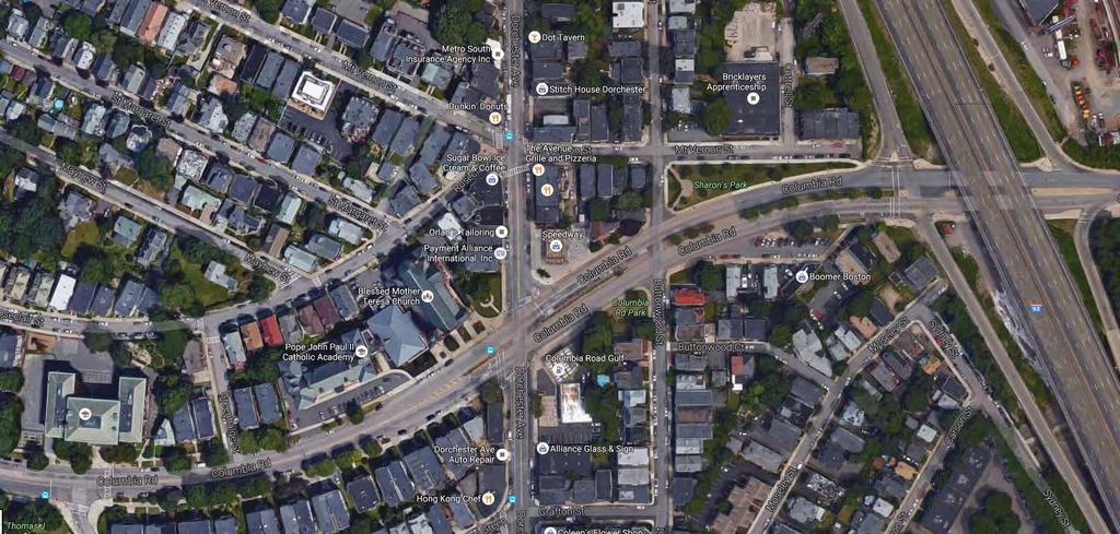
3 Road Safety Audit Columbia Road at Dorchester Avenue Prepared by MDM Transportation Consultants, Inc. FINAL Background The focus of this (Road Safety Audit) RSA was at the intersection of Columbia Road at Dorchester Avenue including the adjacent unsignalized intersection of Columbia Avenue and Buttonwood Street. These intersections have been identified by the State as High Crash Clusters ( ) and are eligible for Highway Safety Improvement Program (HSIP) funding. According to MassDOT s website an HSIP eligible cluster is one in which the total number of "equivalent property damage only" crashes in the cluster is within the top 5% of all clusters in that region. Where equivalent property damage only" is defined by MassDOT as, a method of combining the number of crashes with the severity of crashes based on a weighted scale where a fatal crash is worth 10, an injury crash is worth 5 and a property damage only crash is worth 1. The RSA is intended to identify potential short term and long term safety improvements that can be evaluated and included as part of future design efforts for reconstruction with an emphasis on reducing injury type collisions. The study locations are shown in Figure 1. A Road Safety Audit was completed for the intersection of Columbia Road at Dorchester Avenue in the Dorchester neighborhood of Boston on August 16, The agenda for the RSA meeting held at St. Margaret s Church Hall in Dorchester is provided in Appendix A of this report. Page 3

4 Road Safety Audit Columbia Road at Dorchester Avenue Prepared by MDM Transportation Consultants, Inc. FINAL Figure 1: Locus Map Page 4
5 Road Safety Audit Columbia Road at Dorchester Avenue Prepared by MDM Transportation Consultants, Inc. FINAL Project Data As shown below in Table 1, the audit team consisted of a multidisciplinary team with representatives from state, regional and local agencies providing expertise in the engineering, planning, maintenance and emergency response fields. Contact information for the RSA attendees is provided in Appendix B of this report. Table 1: Participating Audit Team Members Audit Team Member Agency/Affiliation Adam Prichard Kevin Fitzgerald Lisa Schletzbaum James Salvia Selam Engida Carlos Cannon Dorothea Hass Amy Archer Saleema Mohamed Zarchy Veaner Amitai Lipton Eric Hogan Rob Ballasty Peter Furth Becca Wolfson Keith Hague Patrick Hoey Robert Michaud Dan Lindquist Jack Lawrence MassDOT Safety MassDOT Safety MassDOT Safety Boston EMS Boston Public HC Boston Police Department Walk Boston Pare Corporation MassDOT MassDOT D6 MassDOT D6 MassDOT D6 MassDOT D6 Northeastern University Boston Cyclists Union EDENS Boston Transportation Department MDM Transportation Consultants, Inc. MDM Transportation Consultants, Inc. MDM Transportation Consultants, Inc. Page 5
6 Road Safety Audit Columbia Road at Dorchester Avenue Prepared by MDM Transportation Consultants, Inc. FINAL Crash Data Crash trends and safety characteristics for the HSIP study intersection is based on crash data obtained from MassDOT and the City for the four-year period covering 2012 through The RSA team was provided an information package that included a detailed crash summary and graphs for each location and collision diagrams, which were prepared based on research of Local and State crash reports. The detailed crash information is provided in Appendix C with overview as follows: o o Columbia Road at Dorchester Avenue. Seventy-three (73) crashes were reported in the influence area of the Dorchester Ave at Columbia Rd signalized intersection approximately 18 per year resulting in a crash rate of 1.63, which is above the District-wide average of The majority of crashes involved angle/ sideswipe collisions (74%) followed by rear-end type collisions (19%). Forty one percent (41%) of the crashes resulted in non-fatal injuries. Approximately eighty-two percent (82%) of collisions occurred under dry roadway conditions. In general, the crashes were evenly distributed through the day with no significant drop-off during the overnight hours (12am to 6am). One fatality was reported involving a parked vehicle attempting to make a U-turn on the eastbound Columbia Road approach in April There were also three (3) pedestrian or bike related incidents. Columbia Road at Buttonwood Avenue. As shown in the collision diagram, the crash reports indicate that approximately 50-percent of the crashes occurred at the adjacent unsignalized intersection of Columbia Road and Buttonwood Street. The majority of the thirty-five (35) collisions at Buttonwood Street were angle crashes and involved drivers taking left turns from Buttonwood Street in conflict with the heavy traffic and multiple lanes on the Columbia Road approach and departure lanes. There were also a significant number of crashes involving left turn traffic from Columbia Road onto Buttonwood Street, a movement that is currently restricted between 4pm and 6pm on weekdays. Public Transportation The Massachusetts Bay Transit Authority (MBTA) operates the following transit services in the immediate study area: o o o Route 8: Bus Route 8 runs from the Harbor Point/UMass Boston to Kenmore Station. The route passes adjacent to the study intersection along Columbia Road. Service generally runs M-F 5:15 am to 1:00 am and Saturdays and Sundays 6:30am to 1:00 am. Route 18: Bus Route 18 runs from the Ashmont Station to Andrew Station. The route passes adjacent to the study intersection along Dorchester Avenue. Service generally runs M-F 4:45 am to 7:00 pm and Saturdays and Sundays 4:45 am to 6:45 pm. Route 41: Bus Route 18 runs from Centre and Eliot Streets to the JFK/Umass St Station. The route passes adjacent to the study intersection along Columbia Road. Service generally runs M-F 5:00 am to 9:30 pm and Saturdays and Sundays 7:40 am to 7:30 pm. Page 6
7 Road Safety Audit Columbia Road at Dorchester Avenue Prepared by MDM Transportation Consultants, Inc. FINAL Traffic Data The RSA team was provided information regarding daily and peak hour traffic volume networks for the study intersections, pedestrian volumes, collision diagrams, graphs, and photo documentation of the various approaches to the study intersections. This information is provided in Appendix D with summary as follows: Daily Traffic Volumes o o Columbia Road: Daily traffic volume on Columbia Road is approximately 15,000 vehicles per day (vpd), according to MassDOT permanent count station just east of Buttonwood Street. Dorchester Avenue: Daily traffic volume on Dorchester Avenue is approximately 10,000 vehicles per day (vpd), according to MassDOT permanent count station just north of Buttonwood Street. Pedestrian Volumes The existing pedestrian crossings at the study location range from minimal to high at the Columbia Road at Dorchester Avenue intersection. The crossings across Dorchester Avenue were approximately 82 during the weekday morning peak hour, 114 during the weekday evening peak hour and 89 during the Saturday midday peak hour. The crossings across Columbia Road were approximately 59 during the weekday morning peak hour, 55 during the weekday evening peak hour and 50 during the Saturday midday peak hour. The exclusive pedestrian phase at the Columbia Avenue/ Dorchester Avenue traffic signal was observed to be operational during the field visit. Page 7
8 Road Safety Audit Columbia Road at Dorchester Avenue Prepared by MDM Transportation Consultants, Inc. FINAL Project Location and Description The focus of this RSA was Columbia Road including its intersections with Dorchester Avenue and Buttonwood Street. The intersections are listed as Highway Safety Improvement Program (HSIP) cluster locations indicating that the study locations have been identified by the State to be located within a top 5% safety cluster in the region. A description of intersections is described below. Columbia Road/ Dorchester Avenue Signalized Dorchester Ave meets Columbia Road to form a four-way signalized intersection under MassDOT jurisdiction. The regulatory speed limits along Columbia Road and Dorchester Avenue are 30 miles per hour (mph). The Columbia Road eastbound approach to the intersection consists of an exclusive left-turn lane, a through travel lane, and a through/right-turn lane. The westbound Columbia Road approach consists of an exclusive left-turn lane, two through lanes, and a channelized right-turn lane. The northbound approach to the intersection consists of a shared left/ through lane and an exclusive right-turn lane. The Dorchester Ave. southbound approach to the intersection consists of a single general-purpose travel lane that operates as a left/through travel lane and an exclusive right turn lane. Painted crosswalks are provided across the northbound, southbound, and eastbound approaches. There is no crosswalk across the Columbia Avenue westbound approach. A painted bike lane is provided on the southbound Dorchester Avenue approach. Columbia Road/Buttonwood Street Unsignalized Buttonwood Street meets Columbia Road to form an unsignalized stop-controlled intersection under MassDOT jurisdiction. The southbound approach to Columbia Road is under STOP sign control. The regulatory speed limit along Buttonwood Street is 30 mph. The Columbia Road eastbound approach to the intersection consists of two through travel lanes, and a shared through/right-turn lane. The westbound Columbia Road approach consists of a marked left/through lane, one through travel lane, and a through/right-turn lane. Buttonwood Street is a one-way roadway in the southbound direction, and consists of a single general-purpose travel lane. No painted crosswalks are provided at the intersection. MBTA Bus Routes 8 and 41 have bus stops provided along Columbia Road just west of the Buttonwood intersection. Page 8
9 Road Safety Audit Columbia Road at Dorchester Avenue Prepared by MDM Transportation Consultants, Inc. FINAL Audit Observations and Potential Safety Enhancements The RSA team participated in a slide show presentation that included information regarding the study locations, which included existing traffic volumes, existing geometric conditions, existing travel speeds, collision diagrams, crash statistics and photographs of the intersections including of each approach. The RSA meeting and presentation conducted on August 16, 2016 was an interactive process in which safety issues, observations and concerns where discussed for the various intersections. The team members then did an in-field visit to both study locations as a group to identify safety issues and areas for improvement for each location. Post visit the observations were discussed and the findings were finalized for each location. The team then discussed potential short and long-term improvements. The subsequent sections of this report summarize the issues and potential improvements by location. Based on field observations, the RSA team determined that the study locations have the following potential safety issues, which are described in detail in the following section: Columbia Road at Dorchester Avenue 1 - On-Street Parking; 2 - Pedestrian Accommodations; 3 - Bicycle Accommodations; 4 - Lane Alignment; 5 - Signage; 6 - Opticom; 7 - Lighting; 8 - Pavement Markings; 9 - Traffic Signal Visibility; 10 - Excessive Corner Radii. Columbia Road at Buttonwood Street 11 - Unsafe Median Break/ Two-Stage Turns; 12 - Excessive Median Length; 13 - Pavement Markings; 14 - Signal Warrant; 15 - Excessive Lane Width; 16 - Signage. The feasibility of implementing the improvements to address the various safety issues may require additional engineering and/or technical review to determine feasibility. Page 9

10 Road Safety Audit Columbia Road at Dorchester Avenue Prepared by MDM Transportation Consultants, Inc. FINAL Columbia Road at Dorchester Avenue Safety Issue #1: On-Street Parking Observations: The segment of Columbia Road between Massachusetts Avenue and Dorchester Avenue includes two twelve foot travel lanes and a two foot paved shoulder in each direction. On-street parking is also allowed which reduces the travel way by approximately 7 feet for a parking lane. Therefore, the resulting travel way is effectively limited to 1.5 travel lanes in each direction. Field observations indicate that while free flow conditions exist vehicles generally use the segment of roadway as two travel lanes in each direction, however, when queueing occurs they stack in a single lane in each direction. The team discussed the peak hour congestion to the west of the study area of Pond Street, which is the location of a Public School. Any lane drops or re-striping would want to consider the congestion and school operations. Team members also indicated that traffic generated by the School at St. Margaret s Church would often double park along Columbia Road during pick-up and drop-off periods. On-Street parking along Columbia Road between Massachusetts Avenue and Dorchester Avenue reduces the travel way to 1 usable lane per direction. A review of the crash data indicates that two crashes were reported that involved on-street parking along the Columbia Road approach and departure from its intersection with Dorchester Avenue. One of the crashes resulted in a fatal injury type collision. Potential Enhancements: 1. Re-stripe Columbia Road to reflect the current use of the roadway and to provide bicycle accommodations by providing one travel lane, one 5-foot bike lane and one 7-foot parking lane in each direction. 2. Consider a parking restriction along Columbia Road during the core hours on weekdays to regain two full travel lanes. 3. Relocate parking within the influence area of the signalized Columbia Road/ Dorchester Avenue intersection. 4. Discuss alternative pick-up/drop-off procedures with the School/Church administration. Page 10


11 Road Safety Audit Columbia Road at Dorchester Avenue Prepared by MDM Transportation Consultants, Inc. FINAL Safety Issue #2: Pedestrian Accommodations Observations: Field observations indicated that the pedestrian crossing lengths, specifically, across the Columbia Road eastbound approach and Dorchester Avenue northbound approach are excessively long at 110 feet and 75 feet long respectively. RSA team members indicated that it would be desirable to provide pedestrian bulb-outs and minimize the curb radii as much as possible to increase pedestrian visibility and safety as well as reduce the crossing lengths. Team members also indicated that that there is a nonfunctioning pedestrian push button in the median for Columbia Road to the east of Dorchester Avenue and there is no pedestrian handicapped ramps or marked crosswalk across the Columbia Road westbound approach. This missing crosswalk is a clear desire line for pedestrians walking along the eastbound side of Dorchester Avenue. Field observations indicate that the handicapped ramps are non-existent on the northwestern and southwestern corners of the intersection. The island in northern crossing obstructs half of the crosswalk and does not provide handicapped ramps. The remaining ramps with the exception of the ramp on the northeastern corner are all missing the truncated domes. RSA team members indicated that it might be desirable to provide concurrent pedestrian phasing at the intersection with leading pedestrian intervals where applicable. A review of the crash data indicates one pedestrian crash, which included a single vehicle hitting a pedestrian within the westbound Columbia Road departure lanes within the crosswalk resulting in a non-fatal injury. The existing pedestrian crossing lengths for the eastbound Columbia Road and northbound Dorchester Avenue approaches are excessively long. There is no handicapped ramp provided in the southeastern corner of the intersection. Page 11
12 Road Safety Audit Columbia Road at Dorchester Avenue Prepared by MDM Transportation Consultants, Inc. FINAL Potential Enhancements: 1. Install pedestrian bulb-out and minimize curb radii to increase pedestrian visibility and safety as well as reduce crossing lengths. 2. Install ADA compliant handicapped ramps and a marked crosswalk across the eastern side of the Columbia Road/ Dorchester Avenue intersection. 3. Install detectable warning panels on all of the handicapped ramps. 4. Evaluate concurrent pedestrian phasing and leading pedestrian intervals and implement the pedestrian intervals if desirable. 5. Evaluate adding a pedestrian refuge area for the Columbia Road crossing on the western side of the intersection. 6. Install ADA compliant handicapped ramps on the northwest corner, southwest corner and island in the northern crossing. Page 12
")

13 Road Safety Audit Columbia Road at Dorchester Avenue Prepared by MDM Transportation Consultants, Inc. FINAL Safety Issue #3: Bicycle Accommodations Observations: There is currently a 5-foot wide bike lane on Dorchester Avenue in the southbound direction and shared bike/travel lane markings (sharrows) on Dorchester Avenue in the northbound direction. Field observations indicate that the bike lane markings through the signalized intersection of Columbia Road/Dorchester Avenue are currently missing. There are currently no bike accommodations along Columbia Avenue within the study area. RSA team members indicated that it would be desirable to reduce lane widths, and remove excess departure lanes to accommodate bike lanes on every approach. Likewise, as outlined under safety issue #1, Columbia Road could be re-striped to reflect the current use of the roadway and to provide bicycle accommodations by providing one travel lane, one 5-foot bike lane and one 7-foot parking lane in each direction. A review of the crash data indicates one bicycle related crash at the intersection in which a bicycle in the southbound direction along Dorchester Street ran the red light. A bike lane is provided on Dorchester Avenue southbound at Columbia Road. Potential Enhancements: Re-stripe the three-lane Columbia Road departure to include two departure lanes and a dedicated bicycle lane. 1. Reduce travel lane width and re-stripe unused departure lanes to provide dedicated bicycle lanes on all approaches to the intersection. 2. Provide bicycle accommodations on Columbia Road as outlined under safety issue #1 and to the east of Dorchester Avenue through updated pavement markings and lane re-allocation. 3. Replace the missing bicycle lane markings through the intersection for the existing bicycle lane in the southbound travel direction along Dorchester Avenue. Page 13


14 Road Safety Audit Columbia Road at Dorchester Avenue Prepared by MDM Transportation Consultants, Inc. FINAL Safety Issue #4: Lane Alignment Observations: Field observations indicated that due to the median island and offset of the exclusive left turn lanes on the Columbia Road approaches to Dorchester Avenue, the approach and departure lanes are staggered by one lane width. As a result the exclusive left turn lanes align with a through departure lane. Furthermore, the Columbia Road westbound approach that is adjacent to the curb-line turns into parking lane in front of St. Margaret s Church. Given the awkward alignment along Columbia Road, the through travel lanes against the curb-line are underutilized. A review of the crash data indicates that approximately two crashes may have occurred due to lane alignment issues on the Columbia Road approaches to Dorchester Avenue. The exclusive left-turn lanes along Columbia Road are staggered resulting in a one-lane stagger for the through travel lanes with respect to their departure lane. The Columbia Road eastbound approach has a staggered alignment. Potential Enhancements: 1. Install painted dotted white lane extension lines (DWLEx) through the intersection to clarify lane shifts and to provide driver guidance. 2. Re-align the exclusive left-turn lanes on Columbia Road. Likewise, re-align the through approach and departure lanes on the Columbia Road approaches. Page 14


15 Road Safety Audit Columbia Road at Dorchester Avenue Prepared by MDM Transportation Consultants, Inc. FINAL Safety Issue #5: Signage Observations: Field observations indicate that there is no lane use signage approaching the intersection. The RSA team noted that one of the through travel lanes in the westbound travel direction along Columbia Road turns into an exclusive left turn without advanced signage available. A through lane becoming an exclusive turn lane results in a lane trap situation. The RSA team also noticed that two No Turn on Red signs (R10-11b) are posted for the channelized right turn lane from Columbia Road westbound to Dorchester Avenue northbound, however, the right turn is channelized and is actually under Yield control. Team members also indicated that one of the two No Turn on Red signs, the one mounted on the traffic signal post, is mounted well below the minimum recommended 7 feet when located on a sidewalk section. Team members also noticed that a third No Turn on Red sign is also posted below the left turn signal on the westbound approach turning left onto Dorchester Avenue. This sign should be replaced with a Left Turn on Green Arrow Only sign (R10-5). There are two No Turn on Red signs on the Columbia Road and the channelized right turn is under Yield control and not STOP control. Columbia Road westbound lane trap and lack of advanced warning/ lane use signage. Potential Enhancements: 1. Evaluate the remove the two non-applicable No Turn on Red signs. 2. Use blank-out sign activated during exclusive pedestrian phases. 3. Install advanced intersection lane use signage on the Columbia Road westbound approach to Dorchester Avenue. Page 15

16 Road Safety Audit Columbia Road at Dorchester Avenue Prepared by MDM Transportation Consultants, Inc. FINAL Safety Issue #6: Opticom Observations: Field observations indicated a significant number of ambulance and other emergency vehicles using this intersection, specifically from I-93 westbound on Columbia Road towards the area hospitals. RSA team members noted that the intersection did not have any emergency pre-emption (Opticom) installed. The team noticed that the majority of the emergency vehicles arrive from the east on Columbia Road and that without emergency pre-emption there was often delay for emergency apparatus due to intersection congestion. The team also noted that drivers attempting to make way for emergency vehicles were often forced into the intersection and became trapped in the middle of the intersection. There is no Opticom available at the intersection and a significant number of emergency apparatus utilize the intersection to gain access to the area hospitals. Potential Enhancements: 1. Install pre-emption system at intersection to enhance emergency response time and to avoid vehicles being trapped in the center of the intersection. Page 16

17 Road Safety Audit Columbia Road at Dorchester Avenue Prepared by MDM Transportation Consultants, Inc. FINAL Safety Issue #7: Lighting Observations: Field observations by the RSA team indicated that the intersection does include street lighting. All of the street lighting at the Columbia Road intersection with Dorchester Avenue are the old style lights and light post and the team members indicated that it would be desirable to update the fixtures to include new LED style fixtures consistent with recent work at other area intersections in the neighborhood. Approximately 32% of the reported crashes occurred at dusk or under dark roadway conditions. Lighting at the intersection of Columbia Road at Dorchester Avenue. Potential Enhancements: 1. Update the street lighting to provide enhanced lighting for the intersection and included LED style light fixtures to reduce energy demand. Page 17

18 Road Safety Audit Columbia Road at Dorchester Avenue Prepared by MDM Transportation Consultants, Inc. FINAL Safety Issue #8: Pavement Markings Observations: Field observations by the RSA team indicated that there are no pavement arrow markings on the through travel lanes or the shared through/right turn lanes. The RSA team observed that the outer shared lanes on Columbia Road are typically underutilized, partly due to lane alignment, lack of lane recognition by drivers, and drivers knowing they will be forced to merge left shortly after traveling through the intersection and on-street parking encroachment. There are no pavement markings for the Columbia Road westbound through/right turn lane which results in vehicles not using the lane as a through travel lane. Potential Enhancements: 1. Install pavement markings including lane designation arrows to increase lane recognition and utilization of travel lanes at the intersection. Page 18

19 Road Safety Audit Columbia Road at Dorchester Avenue Prepared by MDM Transportation Consultants, Inc. FINAL Safety Issue #9: Traffic Signal Visibility Observations: Field observations by the RSA team indicated that the traffic signal head on the Columbia Road westbound approach in the splitter island is dull. Potential Enhancements: The traffic signal indication on the Columbia Road westbound approach is dull. 1. Check the visibility of the traffic signal heads at the Columbia Road intersection with Dorchester Avenue and replace with new LED type lenses as required to enhance visibility. Page 19

20 Road Safety Audit Columbia Road at Dorchester Avenue Prepared by MDM Transportation Consultants, Inc. FINAL Safety Issue #10: Excessive Corner Radii Observations: RSA team participants noted that excessive corner radii allow turning vehicles to travel at higher speeds through the intersection. Specifically, the team noted large radii on the northbound Dorchester Avenue turn onto Columbia Road eastbound and the southbound Dorchester Avenue approach to Columbia Road westbound. The larger corner radii also increased the crosswalk length and time needed for pedestrian crossings as outlined in safety issue #2. Field observations indicate a high volume of heavy vehicles that use the intersection; therefore, any tightening of the corner radii should be done in a way to still accommodate the larger vehicles. Potential Enhancements: The Dorchester Avenue right turn corner radii onto Columbia Road eastbound allow for a high-speed turn. 1. Reduce the corner radii at the Columbia Road/ Dorchester Avenue intersection as appropriate to reduce turn speeds. Page 20


21 Road Safety Audit Columbia Road at Dorchester Avenue Prepared by MDM Transportation Consultants, Inc. FINAL Columbia Road at Buttonwood Street Safety Issue #11: Unsafe Median Break/ Two-Stage Turns Observations: Field observations by the RSA team at the adjacent intersection of Columbia Road and Buttonwood Street indicated that a significant number of vehicles along Dorchester Avenue traveling southbound using Buttonwood to by-pass the traffic signal at Columbia Road/Dorchester Avenue. An unsignalized left-turn movement from Buttonwood Street across three westbound travel lanes on Columbia Road and then a merge into the eastbound travel lanes on Columbia Road typically results in a two-stage turn. The RSA team observed that the median is too narrow for a vehicle to stage itself and often leaves the inner westbound Columbia Road lane blocked. A review of the accident data indicates that approximately 35 crashes occurred at the intersection of Columbia Road/ Buttonwood Street including 12 crashes that included vehicles exiting Buttonwood Street onto Columbia Road. The RSA team noticed multiple near-miss occurrences in a short timespan while observing this intersection. The crash data indicates that at least seven of the crashes were courtesy crash types, where a courtesy crash is defined as a condition when a vehicle in one-lane stops to let a vehicle turn, but a vehicle in the adjoining lane does not see the turning vehicle, resulting in a crash with the turning vehicle. Likewise, a significant number of vehicles traveling westbound on Columbia Avenue turn left onto Buttonwood Street to by-pass the traffic signal at Columbia Road/Dorchester Avenue. A review of the accident data indicates that approximately 12 crashes included vehicles exiting Columbia Road onto Buttonwood Street. Simultaneous double left turn and through movements from Buttonwood Street onto or across Columbia Road. The two-stage turn also blocks the westbound Columbia Road approach lane. Left turn from Columbia Road onto Buttonwood Street is restricted (with signage) from 4-6pm. Potential Enhancements: 1. Widen the median to allow vehicles to properly make two-stage turns without blocking adjacent travel lanes. 2. Close the median break and restrict Buttonwood movements to only right turns. 3. Provide signage to restrict left turns from Buttonwood Street onto Columbia Road. Page 21
 is provided along Columbia Road at its intersection with")
22 Road Safety Audit Columbia Road at Dorchester Avenue Prepared by MDM Transportation Consultants, Inc. FINAL Safety Issue #12: Excessive Median Length Observations: The RSA team mentioned that an excessively long median break (80± feet) is provided along Columbia Road at its intersection with Buttonwood Street. The excessive median length promotes multiple simultaneous turning vehicles onto Buttonwood Street southbound and from Buttonwood Street onto Columbia Road. Field observations indicated that vehicles stack side by side in the narrow median area. An 80-foot long median break is provided at Buttonwood Street. Potential Enhancements: 1. Shorten the median break length as to not promote multiple vehicles wide staging. Page 22


23 Road Safety Audit Columbia Road at Dorchester Avenue Prepared by MDM Transportation Consultants, Inc. FINAL Safety Issue #13: Pavement Markings Observations: Field observations by the RSA team indicated that there is a significant lack of pavement markings on the Buttonwood Street southbound approach to Columbia Road. Specifically, there is no STOP bar and no marked crosswalk for the Buttonwood Street approach to Columbia Road. Likewise, there is no marked crosswalk on the Buttonwood Street departure from Columbia Road. The RSA team discussed the potential desirability to install Do Not Block the Box markings on Columbia Road at its intersection with Buttonwood Street that would assist vehicles turning from Buttonwood Street through westbound queues that often extend back from the adjacent traffic signal at Columbia Road/Dorchester Avenue. However, it was also concern that Do Not Block the Box markings could potentially lead to an increase in courtesy crashes. No STOP bar or crosswalk markings on the Buttonwood Street approach to Columbia Road. Columbia Road westbound traffic queued through the Buttonwood Street intersection. Potential Enhancements: 1. Install a STOP bar on the Buttonwood Street approach to Columbia Road. 2. Install crosswalk markings for the crosswalks across Buttonwood Street. 3. Add Do Not Block the Box pavement markings and signage at the intersection to create gaps in queued vehicles along Columbia Road. Page 23


24 Road Safety Audit Columbia Road at Dorchester Avenue Prepared by MDM Transportation Consultants, Inc. FINAL Safety Issue #14: Signal Warrant Observations: Field observations by the RSA team indicated that a large number of vehicles from both Buttonwood Street and Columbia Road make turning movements at this unsignalized intersection. Due to the high volume, high crash rate and influence from the nearby traffic signals at Columbia Road/ Dorchester Avenue and Columbia Road/ I-93 southbound ramps, a traffic signal warrant should be examined for this intersection. The proximity to the adjacent signals at the Columbia Road/Dorchester Avenue and Columbia Road/I-93 southbound ramps was noted by team members and the potential to coordinate the traffic signals may be desirable. The team noted that coordination of a future traffic signal at Columbia Road/Buttonwood Street traffic signal would not only allow safer turning movements onto Columbia Road while not significantly impeding the Columbia Road traffic stream. The RSA team also noted that a traffic signal at this location would also be an opportunity to provide a pedestrian crossing across Columbia Road connecting the southern side of Columbia Road with an existing desire line to an existing transit stop at the intersection. A traffic signal may be warranted given the turning movement demand from Buttonwood Street onto Columbia Road. Potential Enhancements: Mid-block pedestrian crossing at Columbia Road/Buttonwood Street. 1. Review the applicable traffic signal warrants and install a traffic signal and associated equipment if warranted. 2. Review and if applicable, coordinate the future traffic signal with the nearby intersections of Columbia Road/ Dorchester Avenue and Columbia Road/I/93 southbound ramps. Page 24

25 Road Safety Audit Columbia Road at Dorchester Avenue Prepared by MDM Transportation Consultants, Inc. FINAL Safety Issue #15: Excessive Lane Widths Observations: Field observations by the RSA team indicated that when travelling eastbound on Columbia Road, the travel lanes appear to be unnecessarily wide. Wide lanes allow for much higher speeds and make crossing said lanes more difficult for vehicles and pedestrians alike. The outer lane appears to have historically been two lanes wide. Installing narrower lanes and reallocating the extra space would allow bike lanes. Relocating the curb-line and/or installing bulb-outs were mentioned as potential solutions in reference to providing shorter crossing distances. Potential Enhancements: Wide travel lanes on Columbia Road could be converted to provide bicycle accommodation. 1. Reduce lane widths and re-allocate the excess pavement area to provide bike lanes along Columbia Road and to reduce travel speeds. 2. Relocate the curb-line and/or installing bulb-outs to provide shorter crossing distances. Page 25


26 Road Safety Audit Columbia Road at Dorchester Avenue Prepared by MDM Transportation Consultants, Inc. FINAL Safety Issue #16: Signage Observations: The RSA team noticed that a sign in the median on Columbia Road prohibits left turn movements onto Buttonwood Street during the weekday evening peak periods of 4PM-6PM. The RSA team noticed that there is no such restriction during the weekday morning peak periods (7AM-9AM) or for the Buttonwood Street left turns onto Columbia Road. Restricting turns from Buttonwood Street during the peak periods should reduce crashes at this intersection given the fact that 13 of the reported crashes at this intersection occurred between the weekday peak periods (7AM-9AM or 4PM-6PM). RSA team members also indicated that there is no keep right (graphic) sign in the raised median for vehicles travelling eastbound on Columbia Road. Missing keep right (graphic) sign in the median for Columbia Road eastbound at Buttonwood Street. Sign restriction is in place for left turns onto Buttonwood Street from Columbia Road westbound between 4PM and 6PM. Potential Enhancements: 1. Restrict left turn movements from Buttonwood Street onto Columbia Road during peak hours through signage. 2. Install a keep right (graphic) sign (R4-7) on the median to alert drivers of the raised median on Columbia Road eastbound. Page 26
27 Road Safety Audit Columbia Road at Dorchester Avenue Prepared by MDM Transportation Consultants, Inc. FINAL Summary of Road Safety Audit After discussing the various safety deficiencies within the study area, participants discussed potential solutions. The audit participants were encouraged to consider both short and long-term improvements for each of the existing safety issues. Each improvement considered has been categorized as short-term, midterm, or long-term based on the definitions shown in Table 2. Additionally, a cost category has been assigned to each improvement based on the parameters set forth in Table 2. Table 2: Estimated Time Frame and Costs Breakdown Time Frame Costs Short-Term <1 Year Low <$10,000 Mid-Term 1-3 Years Medium $10,001-$50,000 Long-Term >3 Years High >$50,000 The RSA is intended to identify potential safety improvements that can be evaluated and included as part of the design process for future reconstruction efforts. The short-term low-cost improvements should be considered by the responsible agency for immediate implementation, as appropriate. A summary of the potential recommendations discussed by the RSA audit team are summarized in Table 3 (Columbia Road at Dorchester Avenue) and Table 4 (Columbia Road at Buttonwood Street). The recommendations are summarized based on the potential safety payoff, time frame, approximate cost, and responsible agency. The safety payoff is a subjective judgment of the potential effectiveness of the safety recommendations listed below. Page 27
28 Road Safety Audit Columbia Road at Dorchester Avenue Prepared by MDM Transportation Consultants, Inc. FINAL Safety Issue On-Street Parking Table 3: Potential Safety Enhancement Summary Columbia Road at Dorchester Avenue Potential Safety Enhancement Re-stripe Columbia Road to reflect current use: one travel lane, one 5- foot bike lane, and one 7-foot parking lane. Consider parking restriction along Columbia Road during the core hours on weekdays. Relocate parking within the influence area of the signalized intersection. Discuss alternative pick-up/dropoff procedures with School/Church administration. Safety Payoff Time Frame Cost Responsible Party High Mid-Term Medium MassDOT High Mid-Term Low High Mid-Term Low Medium Short-Term Low MassDOT/ City of Boston MassDOT/ City of Boston MassDOT/ City of Boston Page 28
29 Road Safety Audit Columbia Road at Dorchester Avenue Prepared by MDM Transportation Consultants, Inc. FINAL Table 3 (Continued): Potential Safety Enhancement Summary Columbia Road at Dorchester Avenue Safety Issue Potential Safety Enhancement Safety Payoff Time Frame Cost Responsible Party Install pedestrian bulb-outs and minimize curb radii. High Long-Term High MassDOT Install ADA compliant handicapped ramps and a marked crosswalk across the eastern side of the High Long-Term Medium MassDOT intersection. Install detectable warning panels on all of the handicapped ramps. High Short-Term Low MassDOT Pedestrian Evaluate/implement concurrent MassDOT/ Accommodations pedestrian phasing and leading Medium Long-Term Medium City of Boston pedestrian intervals Evaluate adding a pedestrian refuge area for the Columbia Road crossing on the western side of the Low Long-Tern Low MassDOT intersection. Install ADA compliant handicapped ramps on the northwest corner, southwest corner and island in the High Mid-Term Medium MassDOT northern crossing Page 29
30 Road Safety Audit Columbia Road at Dorchester Avenue Prepared by MDM Transportation Consultants, Inc. FINAL Safety Issue Bicycle Accommodations Table 3 (Continued): Potential Safety Enhancement Summary Columbia Road at Dorchester Avenue Potential Safety Enhancement Reduce travel lane width and restripe un-used departure lanes to provide dedicated bicycle lanes. Provide bicycle accommodations on Columbia Road and to the east of Dorchester Avenue. Replace missing bicycle lane markings through the intersection for the existing bicycle lane in the southbound travel direction along Dorchester Avenue. Safety Payoff Time Frame Cost Responsible Party High Long-Term Medium MassDOT High Long-Term Medium MassDOT Low Short-Term Low MassDOT Lane Alignment Paint dotted white lane extension lines (DWLEx) through the intersection to clarify lane shifts. Re-align the exclusive left-turn, through lanes, and departure lanes on Columbia Road. High Short-Term Low MassDOT High Long-Term High MassDOT Signage Remove the two non-applicable No Turn on Red signs. Use Blank-out sign activated during exclusive pedestrian phases. Install advanced intersection lane use signage on the Columbia Road westbound approach to Dorchester Avenue. Low Short-Term Low MassDOT Low Long-Term Low MassDOT Medium Short-Term Low MassDOT Page 30
31 Road Safety Audit Columbia Road at Dorchester Avenue Prepared by MDM Transportation Consultants, Inc. FINAL Safety Issue Opticom Table 3 (Continued): Potential Safety Enhancement Summary Columbia Road at Dorchester Avenue Potential Safety Enhancement Install pre-emption system at intersection to enhance emergency response time and to avoid vehicles being trapped in the center of the intersection. Safety Payoff Time Frame Cost Responsible Party High Long-Term Medium MassDOT/ City of Boston Lighting Update the street lighting to provide enhanced lighting for the intersection and included LED style light fixtures to reduce energy demand. Low Medium-Term Medium City of Boston Pavement Markings Install pavement markings including lane designation arrows to increase lane recognition and utilization of travel lanes at the intersection. Medium Short-Term Low MassDOT Traffic Signal Visibility Check the visibility of the traffic signal heads at the Columbia Road intersection with Dorchester Avenue and replace with new LED type lenses as required to enhance visibility. Medium Short-Term Medium MassDOT/ City of Boston Excessive Corner Radii Reduce the corner radii at the Columbia Road/ Dorchester Avenue intersection as appropriate to reduce turn speeds. High Long-Term High MassDOT Page 31
32 Road Safety Audit Columbia Road at Dorchester Avenue Prepared by MDM Transportation Consultants, Inc. FINAL Safety Issue Unsafe Median Break/ Two-Stage Turns Table 4: Potential Safety Enhancement Summary Columbia Road at Buttonwood Street Potential Safety Enhancement Safety Payoff Time Frame Cost Responsible Party Widen median to allow vehicles to properly make two-stage turns. High Long-Term Medium MassDOT Close median break and restrict Buttonwood movements to right High Long-Term Medium MassDOT turns only. Provide signage to restrict left turns from Buttonwood Street onto Low Short-Term Low MassDOT Columbia Road Excessive Median Width Shorten median break length as not promote multiple vehicle staging. to High Long-Term Medium MassDOT Pavement Markings Install a STOP bar on the Buttonwood Street approach to Columbia Road. Install crosswalk markings across Buttonwood Street. Add Do Not Block the Box pavement markings and signage at the intersection. Low Short-Term Low Low Short-Term Low MassDOT/ City of Boston MassDOT/ City of Boston Low Short-Term Low MassDOT Signal Warrant Review applicable traffic signal warrants. Install if warranted. Review and if applicable, coordinate future signal with nearby intersections. High Long-Term High MassDOT High Long-Term Medium MassDOT Page 32
33 Road Safety Audit Columbia Road at Dorchester Avenue Prepared by MDM Transportation Consultants, Inc. FINAL Safety Issue Excessive Lane Widths Table 4 (Continued): Potential Safety Enhancement Summary Columbia Road at Buttonwood Street Potential Safety Enhancement Reduce lane widths and reallocate excess pavement to provide bicycle lanes along Columbia Road. Relocate curb-line and/or install bulb-outs to provide shorter crossing distances. Safety Payoff Time Frame Cost Responsible Party High Long-Term Medium MassDOT High Long-Term High MassDOT Signage Restrict left turn movements from Buttonwood Street onto Columbia Road during peak hours through signage. Install a keep right (graphic) sign (R4-7) on the median to alert drivers if the raised median on Columbia Road eastbound. High Short-Term Low MassDOT Medium Short-Term Low MassDOT Page 33
34 Appendix A. RSA Meeting Agenda


35 Road Safety Audit Dorchester MEETING LOCATION: St. Margaret s Church Hall Roseclair Street Entrance, Dorchester DATE: Tuesday August 16, 2016 TIME: 1:00 PM 3:00 PM Type of meeting: Road Safety Audit Columbia Road at Dorchester Avenue Attendees: Invited Participants to Comprise a Multidisciplinary Team 1:00 PM Welcome and Introductions 1:15 PM Review of Site-Specific Material Crash Summary Data & Collision Diagrams See Attached Existing Geometries and Conditions Aerial Orthophoto and photos 2:00 PM Visit the Site Location In-field review of intersection including Buttonwood Street As a group, identify safety issues and areas for improvement at each location 2:30 PM Post Visit Discussion / Completion of RSA Discuss observations and finalize findings Discuss potential improvements and finalize recommendations 3:00 PM Adjourn for the Day but the RSA has not ended Instructions for Participants: Before attending the RSA on August , participants are encouraged to drive through the intersections and complete/consider elements on the RSA Prompt List with a focus on safety. All participants will be actively involved in the process throughout. Participants are encouraged to come with thoughts and ideas, but are reminded that the synergy that develops and respect for others opinions are key elements to the success of the overall RSA process. After the RSA meeting, participants will be asked to comment and respond to the document materials to assure it is reflective of the RSA completed by the multidisciplinary team.
36 Appendix B. RSA Audit Team Contact List
37 Participating Audit Team Members Date: August 16, 2016 Location: 800 Columbia Road Dorchester, MA Audit Team Members Agency/Affiliation Address Phone Number Adam Prichard MassDOT Safety (316) Kevin Fitzgerald MassDOT Safety (857) Lisa Schletzbaum MassDOT Safety (857) James Salvia Boston EMS (617) Selam Engida Boston Public HC (617) Carlos Cannon Boston Police Department (617) Dorothea Hass Walk Boston (617) Amy Archer Pare Corperation (401) Saleema Mohamed MassDOT (857) Zachary Veaner MassDOT D6 (857) Amitai Lipton MassDOT D6 (857) Eric Hogan MassDOT D6 (857) Rob Ballasty MassDOT D6 (857) Peter Furth Northeastern University (617) Becca Wolfson Boston Cyclists Union (315) Keith Hague EDENS (617) Patrick Hoey Boston Transportation Department (617) Robert Michaud MDM Transportation Consultants, Inc. (508) Dan Lindquist MDM Transportation Consultants, Inc. (508) Jack Lawrence MDM Transportation Consultants, Inc. (508)
38 Appendix C. Detailed Crash Data
39
40 TABLE A3 CRASH SUMMARY COLUMBIA ROAD AT DORCHESTER AVENUE & BUTTONWOOD STREET JANUARY 2012 THROUGH DECEMBER 2015 Crash Collision Roadway Roadway (#) Date Day of Week Time of Day (Type) Lighting Weather Condition Condition Severity Ages Comments Columbia Avenue at Dorchester Avenue 1 January 5, 2012 Thursday 7:14 Angle Daylight Clear Dry Non-Fatal Injury Crossing Columbia Road first 2 lanes let car go, did not see car in 3 rd lane 2 January 17, 2012 Tuesday 00:00 Single Vehicle Dark Snow Snow Property Damage Only 35 Lost control due to snow 3 January 27, 2012 Friday 10:38 Angle Daylight Rain Wet Non-Fatal Injury Attempted U-Turn. Cited for failing to grant right of way 4 February 1, 2012 Wednesday 5:00 Angle Dark Cloudy Dry Non-Fatal Injury Signals operating in flash mode 5 February 27, 2012 Monday 15:36 Angle Daylight Clear Dry Property Damage Only Cut off trying to cross Columbia Road. Cited for failure to yield right of way 6 March 11, 2012 Sunday 13:38 Angle Dark Clear Dry Non-Fatal Injury Signals operating in flash mode 7 April 8, 2012 Sunday 11:28 Sideswipe Daylight Clear Dry Property Damage Only Merging into right lane. 8 April 12, 2012 Thursday 14:55 Angle Daylight Clear Dry Fatal Injury Attempting U-Turn from parking space. Transported to Boston Medical Center 9 May 15, 2012 Tuesday 7:21 Rear End Daylight Clear Dry - Driver stated gas pedal stuck to floor. Cited for failure to stop. 10 May 30, 2012 Wednesday 8:19 Angle Daylight Clear Dry Non-Fatal Injury Cut off trying to cross Columbia Road. Cited for failure to yield right of way 11 June 21, 2012 Thursday 20:58 Angle Dark Clear Dry Property Damage Only Backing up in Hess parking lot 12 July 6, 2012 Friday 5:55 Angle Daylight Clear Dry Non-Fatal Injury Signals operating in flash mode. Cited for failure to yield right of way 13 August 8, 2012 Wednesday 13:19 Angle Daylight Clear Dry Non-Fatal Injury Crossing Columbia Road first 2 lanes let car go, did not see car in 3 rd lane 14 August 16, 2012 Thursday 19:20 Rear end Daylight Clear Dry Property Damage Only Citation for failure to use care in stopping 15 September 4, 2012 Tuesday 16:58 Angle Daylight Cloudy Wet Non-Fatal Injury Crossing Columbia Road first lane let car go, did not see car in 2nd lane 16 September 8, 2012 Saturday 13:20 Angle Daylight Clear Dry Non-Fatal Injury Crossing Columbia Road first 2 lanes let car go, did not see car in 3 rd lane 17 September 18, 2012 Tuesday 22:16 Sideswipe Dark Windy Dry Property Damage Only Merging into left lane. 18 October 7, 2012 Sunday 15:30 Angle Daylight Rain Wet Property Damage Only 29 - Exiting Hess attempting to merge to left lane on Columbia. Cited for failing to yield to on coming traffic 19 October 13, 2012 Saturday 17:30 Angle Daylight Clear Dry Property Damage Only Hit and Run 20 October 18, 2012 Thursday 5:08 Angle Dark Clear Dry Non-Fatal Injury Signals operating in flash mode 21 November 1, 2012 Thursday 10:48 Rear End Daylight Clear Dry Property Damage Only Trailer was struck 22 December 5, 2012 Wednesday 7:53 Angle Daylight Clear Dry Property Damage Only Exiting Hess onto Columbia Road first 2 lanes let car go, did not see car in 3 rd lane 23 December 5, 2012 Wednesday 8:40 Angle Dark Clear Dry Property Damage Only Exiting St. Margaret s driveway 24 December 26, 2012 Wednesday 14:30 Sideswipe Daylight Clear Dry Non-Fatal Injury Merging into left turn lane 25 December 26, 2012 Wednesday 18:40 Rear End Dark Rain Wet Non-Fatal Injury Stopped short to take left onto Buttonwood Street 26 December 31, 2012 Monday 9:40 Rear end Daylight Clear Dry Property Damage Only Distracted Looking at GPS 27 January 24, 2013 Thursday 14:10 Angle Daylight Clear Dry Property Damage Only Cut-off trying to merge into left turn lane 28 February 2, 2013 Saturday 4:20 Angle Dark Clear Dry Non-Fatal Injury Signals operating in flash mode 29 February 17, 2012 Sunday 2:10 Rear End Dark Clear Dry Property Damage Only 46 24
41 TABLE A3 CRASH SUMMARY COLUMBIA ROAD AT DORCHESTER AVENUE & BUTTONWOOD STREET JANUARY 2012 THROUGH DECEMBER 2015 Crash Collision Roadway Roadway (#) Date Day of Week Time of Day (Type) Lighting Weather Condition Condition Severity Ages Comments Columbia Avenue at Dorchester Avenue 30 February 17, 2013 Sunday 16:20 Rear End Daylight Rain Wet Property Damage Only Hit and run 31 March 10, 2013 Sunday 1:20 Rear end Daylight Clear Dry Non-Fatal Injury Bus Rear Ended by taxi 32 March 10, 2013 Sunday 18:00 Single Vehicle Daylight Clear Dry Non-Fatal Injury Pedestrian hit while crossing 33 March 13, 2013 Wednesday 3:42 Rear End Daylight Clear Dry Non-Fatal Injury Warning issued for failure to stop 34 April 23, 2013 Tuesday 13:28 Sideswipe Dusk Clear Dry Property Damage Only Hit and run 35 April 25, 2013 Thursday 7:55 Angle Daylight Clear Dry Property Damage Only April 27, 2013 Saturday 9:00 Rear End Daylight Clear Dry Non-Fatal Injury Following too close 37 May 20, 2013 Monday 14:45 Sideswipe Daylight Cloudy Dry Property Damage Only Expired license 38 June 14, 2013 Friday 15:45 Rear End Daylight Cloudy Dry Property Damage Only Revoked license 39 November 11, 2013 Monday 8:10 Angle Daylight Clear Dry Property Damage Only Attempted to make left turn from right lane 40 November 26, 2013 Tuesday 17:33 Angle Dark Clear Dry Property Damage Only December 27, 2013 Friday 20:39 Rear End Dark Cloudy Dry Property Damage Only Hit and run 42 March 11, 2014 Tuesday 22:23 Angle Dark Cloudy Dry Non-Fatal Injury Cut-off trying to merge into left turn lane 43 March 16, 2014 Sunday 1:58 Angle Daylight Clear Dry Non-Fatal Injury March 16, 2014 Sunday 23:23 Sideswipe Dark Cloudy Dry Property Damage Only Exiting parking space on street. Cited for OUI 45 April 3, 2014 Thursday 8:44 Rear End Daylight Clear Dry Property Damage Only Following too close 46 April 4, 2014 Friday 12:00 Angle Daylight Clear Dry Property Damage Only April 10, 2014 Thursday 16:45 Rear End Daylight Clear Dry Non-Fatal Injury Unlicensed driver 48 May 2, 2014 Friday 13:44 Angle Daylight Clear Dry Property Damage Only Ran red light 49 May 8, 2014 Thursday 8:10 Angle Daylight Clear Dry Non-Fatal Injury Taking left turn cut off oncoming traffic 50 May 11, 2014 Sunday 14:55 Angle Daylight Clear Dry Non-Fatal Injury Taking left turn cut off oncoming motorcycle 51 May 14, 2014 Wednesday 17:08 Angle Daylight Clear Dry Property Damage Only Turning left from Buttonwood cut off oncoming traffic 52 June 13, 2014 Friday 3:15 Sideswipe Dark Rain Wet Property Damage Only Merging into left turn lane 53 June 20, 2014 Friday 9:00 Angle Daylight Clear Dry Property Damage Only Bicycle ran red light 54 October 8, 2014 Wednesday 17:45 Angle Daylight Clear Dry Non-Fatal Injury Turning left from Buttonwood cut off oncoming traffic 55 October 14, 2014 Tuesday 13:12 Angle Daylight Clear Dry Property Damage Only Making left first 2 lanes let car go, did not see car in 3 rd lane 56 December 8, 2014 Monday 16:00 Sideswipe Dusk Rain Wet Property Damage Only Merging into right turn lane 57 December 11, 2014 Thursday 16:51 Rear End Dark Clear Dry Property Damage Only Cited for following too close 58 January 16, 2015 Friday 14:20 Angle Daylight Clear Dry Property Damage Only Edged out of Buttonwood in heavy traffic 59 March 4, 2015 Wednesday 9:19 Angle Daylight Snow Wet Property Damage Only Making left first 2 lanes let car go, did not see car in 3 rd lane 60 March 26, 2015 Thursday 7:21 Angle Daylight Cloudy Dry Property Damage Only Merging into left turn lane. Unlicensed driver 61 April 18, 2015 Saturday 15:35 Sideswipe Daylight Clear Dry Non-Fatal Injury May 24, 2015 Sunday 12:25 Single Vehicle Daylight Clear Dry Non-Fatal Injury Hit pedestrian walking bike in crosswalk 63 June 26, 2105 Friday 11:03 Sideswipe Dark Clear Dry Non-Fatal Injury Motorcycle ran red light 64 July 12, 2015 Sunday 4:03 Single Vehilce Dark - - Property Damage Only Hit pole after brakes failed 65 July 14, 2015 Tuesday 11:19 Angle Daylight Clear Dry Property Damage Only Cars turning left and right onto Columbia merged into same lane 66 September 13, 2015 Tuesday 4:15 Head On Dark Clear Dry Property Damage Only Driving in wrong direction. Arrested for OUI 67 September 26, 2015 Saturday 3:13 Angle Daylight Clear Dry Non-Fatal Injury Attempting to make a U-turn
42 TABLE A3 CRASH SUMMARY COLUMBIA ROAD AT DORCHESTER AVENUE & BUTTONWOOD STREET JANUARY 2012 THROUGH DECEMBER 2015 Crash Collision Roadway Roadway (#) Date Day of Week Time of Day (Type) Lighting Weather Condition Condition Severity Ages Comments Columbia Avenue at Dorchester Avenue 68 October 10, 2015 Saturday 00:00 Angle Dark Clear Dry Non-Fatal Injury Cited for failure to yield and suspended license 69 October 11, 2015 Sunday 1:35 Sideswipe Dark Clear Dry Property Damage Only Merging into left turn lane. Unlicensed driver 70 October 14, 2015 Wednesday 5:50 Angle Dusk Clear Dry Property Damage Only Both drivers reported having green light 71 December 2, 2015 Wednesday 12:29 Angle Daylight Rain Wet Property Damage Only Ran red light 72 December 6, 2015 Sunday 7: Non-Fatal Injury Failure to stop 73 December 31, 2015 Thursday 1:25 Angle Daylight Cloudy Dry Non-Fatal Injury Making left first 2 lanes let car go, did not see car in 3 rd lane
43 Columbia Road at Dorchester Avenue and Buttonwood Street Percentage 16% 14% 12% 10% 8% 6% 4% 2% 0% Crashes by Month 15% 12% 12% 11% 11% 7% 7% 7% 7% 4% 4% 3% January February March April May June July August September October November December Month Crashes by Day of the Week 25% 20% 18% 21% 19% Percentage 15% 10% 7% 14% 12% 10% 5% 0% Monday Tuesday Wednesday Thursday Friday Saturday Sunday Day Percentage 16% 14% 12% 10% 8% 6% 4% 2% 0% Crashes by Time of Day 15% 12% 12% 12% 10% 8% 8% 7% 5% 4% 3% 3% 12-2 AM 2-4 AM 4-6 AM 6-8 AM 8-10 AM PM 12-2 PM 2-4 PM 4-6 PM 6-8 PM 8-10 PM AM Time Crashes by Crash Type Percentage 70% 60% 50% 40% 30% 20% 10% 0% 59% 19% 15% 1% 5% 0% Angle Rear-End Head-On Sideswipe Single Vehicle Unknown/Other Crash Type
44 Columbia Road at Dorchester Avenue and Buttonwood Street 70% 60% 66% Crashes by Roadway Lighting Percentage 50% 40% 30% 20% 10% 0% 27% 5% 0% 1% Daylight Dark - Lit Roadway Dusk Dawn Unknown Roadway Lighting Percentage 80% 70% 60% 50% 40% 30% 20% 10% 0% Crashes by Weather Condition 74% 11% 10% 3% 0% 3% Clear Cloudy Rain Snow Sleet/Hail Unknown Weather Condition Crashes by Roadway Condition Percentage 90% 80% 70% 60% 50% 40% 30% 20% 10% 0% 82% 12% 3% 3% Dry Wet Snow Unknown/Other Roadway Condition Percentage 60% 50% 40% 30% 20% 56% Crashes by Crash Severity 41% 10% 0% Property Damage Only Non-Fatal Injury Fatal Crash Severity 1%
45 Appendix D. Additional Information
 Tuesday, August 16, 2016 St.")
46 Road Safety Audit Boston, MA Dorchester Neighborhood Columbia Road at Dorchester Avenue (Including Buttonwood Street) Tuesday, August 16, 2016 St. Margaret s Church Hall Roseclair Street Entrance
47 Meeting Outline 1:00 PM Welcome and Introductions 1:15 PM Review of Site Specific Material Crash Summary Data & Collision Diagrams Existing Geometries and Conditions Aerial and Photographs 2:00 PM Visit the Site Location In Field review of intersection including Buttonwood Street As a group, identify safety issues and areas for improvement at each location 2:30 PM Post Visit Discussion/ Completion of RSA Discuss Observations and Finalize Findings Discuss Potential Improvements and finalize recommendations 3:00 PM Abjourn for the Day but the RSA has not ended
48 Welcome and Introductions Robert J. Michaud, PE, Managing Principal Daniel C. Lindquist, Transportation Engineer MDM Transportation Consultants, Inc. 28 Lord Road, Suite 280 Marlborough, MA (508)
49 Neighborhood Context

50 Study Locations

51 Daily Traffic Volumes
52 Existing Volumes (7:30-8:30 AM) Vehicular Volumes Pedestrian & Bicycle Volumes
53 Existing Volumes (4:45-5:45PM) Vehicular Volumes Pedestrian & Bicycle Volumes
54 Existing Volumes (12:00-1:00 PM) Vehicular Volumes Pedestrian & Bicycle Volumes


55 Existing Travel Speeds Regulatory (Prima-Facie) Travel Speed = 30 mph
56 Intersection Layout
57 Traffic Signal Sequence
58 Collision Diagram

59 Crash Data Sheet 1 of 3

60 Crash Data Sheet 2 of 3
61 Crash Data Sheet 3 of 3
62 Crash Data - Graphs

63 Conceptual Improvements Plan
ROAD SAFETY AUDIT. Blue Hill Avenue (Route 28) and Warren Street High Crash Locations City of Boston. November 1, 2016
 and Warren Street High Crash Locations City of Boston. November 1, 2016") ROAD SAFETY AUDIT Blue Hill Avenue (Route 28) and Warren Street High Crash Locations City of Boston November 1, 2016 Prepared For: MassDOT Highway Division Prepared By: BETA Group, Inc. Table of Contents
ROAD SAFETY AUDIT Blue Hill Avenue (Route 28) and Warren Street High Crash Locations City of Boston November 1, 2016 Prepared For: MassDOT Highway Division Prepared By: BETA Group, Inc. Table of Contents
ROAD SAFETY AUDIT. Granite Avenue at Interstate 93 Ramps. Town of Milton. May 22, Prepared for: MassDOT
 ROAD SAFETY AUDIT Granite Avenue at Interstate 93 Ramps Town of Milton May 22, 2017 Prepared for: MassDOT Prepared by: Toole Design Group 2 Oliver Street, Suite 305 Boston, MA 02109 Table of Contents Background...
ROAD SAFETY AUDIT. Route 114 at Interstate I-495 Northbound Ramps. City of Lawrence. July 30, 2015
 ROAD SAFETY AUDIT Route 114 at Interstate I-495 Northbound Ramps City of Lawrence July 30, 2015 Prepared For: Massachusetts Department of Transportation Prepared By: Toole Design Group 33 Broad Street,
ROAD SAFETY AUDIT. Centre Street (Route 123) at Plymouth Street. Municipality of Brockton. November, Prepared For: MassDOT
 at Plymouth Street. Municipality of Brockton. November, Prepared For: MassDOT") ROAD SAFETY AUDIT Centre Street (Route 123) at Plymouth Street Municipality of Brockton November, 2017 Prepared For: MassDOT On Behalf Of: City of Brockton Prepared By: Old Colony Planning Council 70 School
ROAD SAFETY AUDIT Centre Street (Route 123) at Plymouth Street Municipality of Brockton November, 2017 Prepared For: MassDOT On Behalf Of: City of Brockton Prepared By: Old Colony Planning Council 70 School
ROAD SAFETY AUDIT. County Street at Hart Street. City of Taunton. January 30, Prepared For: Massachusetts Department of Transportation
 ROAD SAFETY AUDIT County Street at Hart Street City of Taunton January 30, 2015 Prepared For: Massachusetts Department of Transportation Prepared By: Toole Design Group 33 Broad Street, 4 th Floor Boston,
ROAD SAFETY AUDIT. Route 16 at Interstate 395 Town of Webster. October Prepared For: MassDOT
 ROAD SAFETY AUDIT Route 16 at Interstate 395 Town of Webster October 2015 Prepared For: MassDOT Prepared By: McMahon Associates, Inc. 300 Myles Standish Blvd. Suite 201 Taunton, MA 02780 Table of Contents
ROAD SAFETY AUDIT. State Road (Route 6) Corridor Town of Dartmouth. March Prepared For: MassDOT
 Corridor Town of Dartmouth. March Prepared For: MassDOT") ROAD SAFETY AUDIT State Road (Route 6) Corridor Town of Dartmouth March 2015 Prepared For: MassDOT Prepared By: McMahon Associates, Inc. 300 Myles Standish Blvd. Suite 201 Taunton, MA 02780 Table of Contents
ROAD SAFETY AUDIT State Road (Route 6) Corridor Town of Dartmouth March 2015 Prepared For: MassDOT Prepared By: McMahon Associates, Inc. 300 Myles Standish Blvd. Suite 201 Taunton, MA 02780 Table of Contents
FLORIDA DEPARTMENT OF TRANSPORTATION DISTRICT 7 DISTRICT WIDE BICYCLE/PEDESTRIAN ACCESS TO TRANSIT SAFETY ASSESSMENT AND IMPROVEMENT PLAN
 FLORIDA DEPARTMENT OF TRANSPORTATION DISTRICT 7 DISTRICT WIDE BICYCLE/PEDESTRIAN ACCESS TO TRANSIT SAFETY ASSESSMENT AND IMPROVEMENT PLAN TRANSIT SAFETY ASSESSMENT SR 55/US 19 AT 80 TH AVE N DRAFT JUNE
Route 28 (South Orleans Road)/Route 39 (Harwich Road)/Quanset Road Intersection
/Route 39 (Harwich Road)/Quanset Road Intersection") TRAFFIC FEASIBILITY STUDY Route 28 (South Orleans Road)/Route 39 (Harwich Road)/Quanset Road Intersection Orleans, Massachusetts Prepared for: Town of Orleans Prepared by: Fay, Spofford & Thorndike, LLC
TRAFFIC FEASIBILITY STUDY Route 28 (South Orleans Road)/Route 39 (Harwich Road)/Quanset Road Intersection Orleans, Massachusetts Prepared for: Town of Orleans Prepared by: Fay, Spofford & Thorndike, LLC
ROAD SAFETY AUDIT. West Central Street (Route 140) at Franklin Village Drive. Town of Franklin. February 03, 2016
 at Franklin Village Drive. Town of Franklin. February 03, 2016") ROAD SAFETY AUDIT West Central Street (Route 140) at Franklin Village Drive Town of Franklin February 03, 2016 Prepared for: Massachusetts Department of Transportation Prepared by: Howard Stein Hudson
ROAD SAFETY AUDIT West Central Street (Route 140) at Franklin Village Drive Town of Franklin February 03, 2016 Prepared for: Massachusetts Department of Transportation Prepared by: Howard Stein Hudson
Date: April 4, Project #: Re: A Street/Binford Street Traffic/Intersection Assessment
 To: Peter Cavanaugh General Electric From: David Bohn, PE Ryan White, PE Date: April 4, 217 Project #: 13421. Re: / Traffic/Intersection Assessment Consistent with the Cooperation Agreement between the
ROAD SAFETY AUDIT. Boston Road (Route 20) at Parker Street and Pasco Road to Dumaine Street City of Springfield Town of Wilbraham.
 at Parker Street and Pasco Road to Dumaine Street City of Springfield Town of Wilbraham.") ROAD SAFETY AUDIT Boston Road (Route 2) at Parker Street and Pasco Road to Dumaine Street City of Springfield Town of Wilbraham October 4, 212 Prepared For: MassDOT Highway Division Prepared By: BETA Group,
ROAD SAFETY AUDIT Boston Road (Route 2) at Parker Street and Pasco Road to Dumaine Street City of Springfield Town of Wilbraham October 4, 212 Prepared For: MassDOT Highway Division Prepared By: BETA Group,
ROAD SAFETY AUDIT. Route 38 from Route 62 to Woburn Town Line. Town of Wilmington. April 10, Prepared For: MassDOT
 ROAD SAFETY AUDIT Route 38 from Route 62 to Woburn Town Line Town of Wilmington April 10, 2017 Prepared For: MassDOT Prepared By: Green International Affiliates, Inc. 239 Littleton Road, Suite 3, Westford,
Summary: Mercer County Princeton Avenue & Spruce Street Study January 2009
 Summary: Several recent studies have assessed potential development and redevelopment opportunities in the Mercer Crossing area of Trenton, Ewing, and Lawrence. This Princeton Avenue and Spruce Street
ROAD SAFETY AUDIT. Russell Street (Route 9) at North and South Maple Streets Town of Hadley. March 2014
 at North and South Maple Streets Town of Hadley. March 2014") ROAD SAFETY AUDIT Russell Street (Route 9) at North and South Maple Streets Town of Hadley March 2014 Prepared for: Massachusetts Department of Transportation Prepared by: Howard/Stein-Hudson Associates
ROAD SAFETY AUDIT Russell Street (Route 9) at North and South Maple Streets Town of Hadley March 2014 Prepared for: Massachusetts Department of Transportation Prepared by: Howard/Stein-Hudson Associates
DEPARTMENT OF ENVIRONMENTAL SERVICES. North Harrison Street (Lee Highway to Little Falls Road) Comparative Analysis. Prepared for:
 Comparative Analysis. Prepared for:") DEPARTMENT OF ENVIRONMENTAL SERVICES North Harrison Street (Lee Highway to Little Falls Road) Comparative Analysis Prepared for: Arlington County Department of Environmental Services 2100 Clarendon Boulevard,
DEPARTMENT OF ENVIRONMENTAL SERVICES North Harrison Street (Lee Highway to Little Falls Road) Comparative Analysis Prepared for: Arlington County Department of Environmental Services 2100 Clarendon Boulevard,
ROAD SAFETY AUDIT. Route 202 (East State Street)/School Street & Route 202 (West State Street)/Pleasant Street/Amherst Street Town of Granby
/School Street & Route 202 (West State Street)/Pleasant Street/Amherst Street Town of Granby") ROAD SAFETY AUDIT Route 202 (East State Street)/School Street & Route 202 (West State Street)/Pleasant Street/Amherst Street Town of Granby March 2013 Prepared for: Massachusetts Department of Transportation
ROAD SAFETY AUDIT Route 202 (East State Street)/School Street & Route 202 (West State Street)/Pleasant Street/Amherst Street Town of Granby March 2013 Prepared for: Massachusetts Department of Transportation
ROAD SAFETY AUDIT. East Main Street (Route 123) at Route I-495 Northbound & Southbound Ramps Town of Norton. May 11, Prepared For: MassDOT
 at Route I-495 Northbound & Southbound Ramps Town of Norton. May 11, Prepared For: MassDOT") ROAD SAFETY AUDIT East Main Street (Route 123) at Route I-495 Northbound & Southbound Ramps Town of Norton May 11, 2016 Prepared For: MassDOT Prepared By: 101 Walnut Street Watertown, MA Road Safety Audit
ROAD SAFETY AUDIT East Main Street (Route 123) at Route I-495 Northbound & Southbound Ramps Town of Norton May 11, 2016 Prepared For: MassDOT Prepared By: 101 Walnut Street Watertown, MA Road Safety Audit
ROAD SAFETY AUDIT. Rourke Bridge at Pawtucket Boulevard (Route 113) City of Lowell. October 5, Prepared For: MassDOT.
 City of Lowell. October 5, Prepared For: MassDOT.") ROAD SAFETY AUDIT Rourke Bridge at Pawtucket Boulevard (Route 113) City of Lowell October, 2017 Prepared For: MassDOT Prepared By: Vanasse Hangen Brustlin, Inc 101 Walnut Street Watertown, MA 02472 Road
ROAD SAFETY AUDIT Rourke Bridge at Pawtucket Boulevard (Route 113) City of Lowell October, 2017 Prepared For: MassDOT Prepared By: Vanasse Hangen Brustlin, Inc 101 Walnut Street Watertown, MA 02472 Road
ROAD SAFETY AUDIT. May 18, Prepared For: MassDOT. On Behalf Of: Town of Milford
 ROAD SAFETY AUDIT East Main Street (Route 16) at Medway Road (Route 109), East Main Street (Route 16) at Quarry Square Driveways, East Main Street (Route 16) at Beaver Street/ Fortune Boulevard Town of
ROAD SAFETY AUDIT. Providence Street (Route 122A) at McKeon Road/Millbury Street. City of Worcester. July 14, Prepared For: MassDOT
 at McKeon Road/Millbury Street. City of Worcester. July 14, Prepared For: MassDOT") ROAD SAFETY AUDIT Providence Street (Route 122A) at McKeon Road/Millbury Street City of Worcester July 14, 2016 Prepared For: MassDOT Prepared By: Stantec Consulting Services, Inc. Burlington, Massachusetts
ROAD SAFETY AUDIT Providence Street (Route 122A) at McKeon Road/Millbury Street City of Worcester July 14, 2016 Prepared For: MassDOT Prepared By: Stantec Consulting Services, Inc. Burlington, Massachusetts
ROAD SAFETY AUDIT. Santilli Circle and Sweetser Circle. Municipality of Everett. March 10, Prepared For: MassDOT
 ROAD SAFETY AUDIT Santilli Circle and Sweetser Circle Municipality of Everett Prepared For: MassDOT On Behalf Of: WYNN Design and Development Prepared By: AECOM 250 Apollo Drive Chelmsford, MA Road Safety
ROAD SAFETY AUDIT. Route 27 (Crescent Street)/Quincy Street/Massasoit Boulevard. City of Brockton. July 24,2013
/Quincy Street/Massasoit Boulevard. City of Brockton. July 24,2013") ROAD SAFETY AUDIT Route 27 (Crescent Street)/Quincy Street/Massasoit Boulevard City of Brockton July 24,2013 Prepared for: Massachusetts Department of Transportation Prepared by: Howard/Stein-Hudson Associates
ROAD SAFETY AUDIT Route 27 (Crescent Street)/Quincy Street/Massasoit Boulevard City of Brockton July 24,2013 Prepared for: Massachusetts Department of Transportation Prepared by: Howard/Stein-Hudson Associates
ROAD SAFETY AUDIT. Route 135 at Route 30 Town of Westborough. January Prepared For: MassDOT
 ROAD SAFETY AUDIT Route 135 at Route 30 January 2016 Prepared For: MassDOT Prepared By: McMahon Associates, Inc. 300 Myles Standish Blvd. Suite 201 Taunton, MA 02780 Road Safety Audit Route 135 at Route
ROAD SAFETY AUDIT. Northampton Road (Route 9) at University Drive and Snell Street Town of Amherst. November 15, Prepared For: MassDOT
 at University Drive and Snell Street Town of Amherst. November 15, Prepared For: MassDOT") ROAD SAFETY AUDIT Northampton Road (Route 9) at University Drive and Snell Street Town of Amherst November 15, 2016 Prepared For: MassDOT Prepared By: Greenman-Pedersen, Inc. 181 Ballardvale Street, Suite
ROAD SAFETY AUDIT Northampton Road (Route 9) at University Drive and Snell Street Town of Amherst November 15, 2016 Prepared For: MassDOT Prepared By: Greenman-Pedersen, Inc. 181 Ballardvale Street, Suite
ROAD SAFETY AUDIT. Route 3A from Evans Street to Abigail Adams State Park. Town of Weymouth. October 12, Prepared For: MassDOT
 ROAD SAFETY AUDIT Route 3A from Evans Street to Abigail Adams State Park Town of Weymouth October 12, 2016 Prepared For: MassDOT Prepared By: Green International Affiliates, Inc. 239 Littleton Road, Suite
ROAD SAFETY AUDIT. Route 53 (Washington Street) High Crash Locations at Route 139 (Schoosett Street) and Route 14 (Congress Street) Town of Pembroke
 High Crash Locations at Route 139 (Schoosett Street) and Route 14 (Congress Street) Town of Pembroke") ROAD SAFETY AUDIT Route 53 (Washington Street) High Crash Locations at Route 139 (Schoosett Street) and Route 14 (Congress Street) Town of Pembroke April 29, 2016 Prepared For: MassDOT Highway Division
ROAD SAFETY AUDIT Route 53 (Washington Street) High Crash Locations at Route 139 (Schoosett Street) and Route 14 (Congress Street) Town of Pembroke April 29, 2016 Prepared For: MassDOT Highway Division
ROAD SAFETY AUDIT. South Street (Route 1A) at East Bacon Street (Route 106) and West Bacon Street Town of Plainville.
 at East Bacon Street (Route 106) and West Bacon Street Town of Plainville.") ROAD SAFETY AUDIT South Street (Route 1A) at East Bacon Street (Route 106) and West Bacon Street Town of Plainville March 15, 2018 Prepared For: MassDOT On Behalf Of: Town of Plainville Prepared By: BETA
ROAD SAFETY AUDIT South Street (Route 1A) at East Bacon Street (Route 106) and West Bacon Street Town of Plainville March 15, 2018 Prepared For: MassDOT On Behalf Of: Town of Plainville Prepared By: BETA
Downtown Traffic Study
 City of Lynn Massachusetts Downtown Traffic Study March 2005 315 Norwood Park South, Norwood, MA 02062 781.255.1982 email: beta@beta-inc.com LYNN DOWNTOWN TRAFFIC STUDY INTRODUCTION The City of Lynn is
Multi-Modal Traffic Analysis. Parisi and Associates
 Mill Valley to Corte Madera Bicycle and Pedestrian Corridor Study Appendix D: Multi-Modal Traffic Analysis Prepared by Parisi and Associates August 2009 Appendix D - Multi-Modal Traffic Analysis Table
MEMORANDUM. Charlotte Fleetwood, Transportation Planner
 MEMORANDUM Date: Updated August 22, 2017 To: Organization: Charlotte Fleetwood, Transportation Planner Boston Transportation Department From: Jason DeGray, P.E., PTOE, Regional Director of Engineering
ROAD SAFETY AUDIT. Auburn Street at Southbridge Street (Route 12) Town of Auburn. March Prepared For: Massachusetts Department of Transportation
 Town of Auburn. March Prepared For: Massachusetts Department of Transportation") ROAD SAFETY AUDIT Auburn Street at Southbridge Street (Route 12) Town of Auburn March 2017 Prepared For: Massachusetts Department of Transportation Prepared By: Vanasse Hangen Brustlin, Inc Union Station
ROAD SAFETY AUDIT Auburn Street at Southbridge Street (Route 12) Town of Auburn March 2017 Prepared For: Massachusetts Department of Transportation Prepared By: Vanasse Hangen Brustlin, Inc Union Station
ROAD SAFETY AUDIT. Water Street (Route 129) at Vernon Street. Town of Wakefield. September Prepared For: MassDOT
 at Vernon Street. Town of Wakefield. September Prepared For: MassDOT") ROAD SAFETY AUDIT Water Street (Route 129) at Vernon Street September 2017 Prepared For: MassDOT Massachusetts Department of Transportation Prepared By: WorldTech Engineering Road Safety Audit Water Street
ROAD SAFETY AUDIT Water Street (Route 129) at Vernon Street September 2017 Prepared For: MassDOT Massachusetts Department of Transportation Prepared By: WorldTech Engineering Road Safety Audit Water Street
CAPE COD COMMISSION 3225 MAIN STREET P.O. BOX 226 BARNSTABLE, MA (508) Fax (508) Transportation Safety Report
 Fax (508) Transportation Safety Report") CAPE COD COMMISSION 3225 MAIN STREET P.O. BOX 226 BARNSTABLE, MA 02630 (508) 362-3828 Fax (508) 362-3136 2006 Transportation Safety Report Bourne: Otis Rotary Harwich: Route 137/Route 39 Orleans: Route
CAPE COD COMMISSION 3225 MAIN STREET P.O. BOX 226 BARNSTABLE, MA 02630 (508) 362-3828 Fax (508) 362-3136 2006 Transportation Safety Report Bourne: Otis Rotary Harwich: Route 137/Route 39 Orleans: Route
ROAD SAFETY AUDIT. Neponset Street Rotary/Pendergast Circle. Town of Norwood. September Prepared For: On Behalf Of:
 ROAD SAFETY AUDIT Neponset Street Rotary/Pendergast Circle Town of Norwood September 2014 Prepared For: On Behalf Of: Westwood Marketplace Holdings LLC Prepared By: 35 New England Business Center Drive
Pedestrian Road Safety Audit
 Pedestrian Road Safety Audit Middlebrook Road From Father Hurley Boulevard to Waring Station Road December 2017 Montgomery County Department of Transportation Table of Contents 1. Introduction... 1 1.1
ROAD SAFETY AUDIT. Route 1 at Everett Street & University Avenue. Town of Norwood. September Prepared For: On Behalf Of:
 ROAD SAFETY AUDIT Route 1 at Everett Street & University Avenue Town of Norwood September 2014 Prepared For: On Behalf Of: Westwood Marketplace Holdings LLC Prepared By: 35 New England Business Center
ROAD SAFETY AUDIT. Route 113 (Storey Avenue) at Woodman Way and Low Street. Newburyport, MA. May 27, Prepared For: MassDOT
 at Woodman Way and Low Street. Newburyport, MA. May 27, Prepared For: MassDOT") ROAD SAFETY AUDIT Route 113 (Storey Avenue) at Woodman Way and Low Street Newburyport, MA May 27, 2015 Prepared For: MassDOT Prepared By: Bayside Engineering, Inc. 600 Unicorn Park Drive Woburn, MA 01801
ROAD SAFETY AUDIT Route 113 (Storey Avenue) at Woodman Way and Low Street Newburyport, MA May 27, 2015 Prepared For: MassDOT Prepared By: Bayside Engineering, Inc. 600 Unicorn Park Drive Woburn, MA 01801
ROAD SAFETY AUDIT. Needham Street and Highland Avenue Corridor. City of Newton and Town of Needham. March 2014
 ROAD SAFETY AUDIT Needham Street and Highland Avenue Corridor City of Newton and Town of Needham March 2014 Prepared for: Massachusetts Department of Transportation Prepared by: Howard/Stein-Hudson Associates
ROAD SAFETY AUDIT. Washington Street (Route 53) at Pleasant Street. Town of Pembroke. June 26, Prepared For: MassDOT Highway Division
 at Pleasant Street. Town of Pembroke. June 26, Prepared For: MassDOT Highway Division") ROAD SAFETY AUDIT Washington Street (Route 53) at Pleasant Street Town of Pembroke June 26, 2014 Prepared For: MassDOT Highway Division Prepared By: BETA Group, Inc. Table of Contents Project Data... 1
ROAD SAFETY AUDIT Washington Street (Route 53) at Pleasant Street Town of Pembroke June 26, 2014 Prepared For: MassDOT Highway Division Prepared By: BETA Group, Inc. Table of Contents Project Data... 1
CURBSIDE ACTIVITY DESIGN
 5 CURBSIDE ACTIVITY DESIGN This chapter provides design guidance for separated bike lanes adjacent to curbside activities including parking, loading and bus stops. Typical configurations are presented
Forest Hills Improvement Initiative
 Forest Hills Improvement Initiative Transportation Action Plan Short Term Recommendations ONLY Final Draft as of April 30, 2008 For Community Review and Feedback Prepared for: The City of Boston Boston
AGENDA ITEM 6 D THOMASVILLE ROAD (HERMITAGE BOULEVARD TO LIVE OAK PLANTATION ROAD) ROADWAY SAFETY AUDIT
 ROADWAY SAFETY AUDIT") May 15, 2018 AGENDA ITEM 6 D THOMASVILLE ROAD (HERMITAGE BOULEVARD TO LIVE OAK PLANTATION ROAD) ROADWAY SAFETY AUDIT TYPE OF ITEM: Discussion STATEMENT OF ISSUE The Florida Department of Transportation
May 15, 2018 AGENDA ITEM 6 D THOMASVILLE ROAD (HERMITAGE BOULEVARD TO LIVE OAK PLANTATION ROAD) ROADWAY SAFETY AUDIT TYPE OF ITEM: Discussion STATEMENT OF ISSUE The Florida Department of Transportation
Draft North Industrial Area-Wide Traffic Plan
 Summary of North Industrial and Hudson Bay Industrial Recommended Improvements Table 1. Summary of s Item Location 1 2 3 4 5 6 7 8 9 10 11 12 Millar Ave north of 51st St Super 8 Motel back lane 400 Block
Orange Center Elementary School
 Drag and drop pic and stretch/crop to the limits of the blue rectangle (delete this text box) Orange Center Elementary School Drag and drop pic and stretch/crop to the limits of the blue rectangle (delete
COMMUNITY MEETING AGENDA
 COMMUNITY MEETING AGENDA Welcome and Introductions SAFE Presentation Project Presentation Priorities Feedback Next Steps Q&A Santa Cruz Avenue Corridor Study 1 Santa Cruz Avenue Corridor Study Community
ROAD SAFETY AUDIT. Falmouth Road (Route 28)/Bearses Way. Town of Barnstable. May Prepared for: Massachusetts Highway Department
/Bearses Way. Town of Barnstable. May Prepared for: Massachusetts Highway Department") ROAD SAFETY AUDIT Falmouth Road (Route 28)/Bearses Way Town of Barnstable May 2009 Prepared for: Massachusetts Highway Department Prepared by: Howard/Stein-Hudson Associates 38 Chauncy Street Boston, MA
ROAD SAFETY AUDIT Falmouth Road (Route 28)/Bearses Way Town of Barnstable May 2009 Prepared for: Massachusetts Highway Department Prepared by: Howard/Stein-Hudson Associates 38 Chauncy Street Boston, MA
Windy Ridge Elementary School
 Windy Ridge Elementary School SCHOOL ROUTE PLAN For WINDY RIDGE ELEMENTARY SCHOOL LOCATION 54 ORANGE COUNTY Prepared for: ORANGE COUNTY SCHOOL ASSESSMENT PROGRAM ORANGE COUNTY PUBLIC WORKS Traffic Engineering
CITY OF WEST LAKE HILLS. Forest View Neighborhood Traffic Calming Study
 CITY OF WEST LAKE HILLS 901 South Mopac Expressway Building V, Suite 220 Austin, Texas 78746 Texas P.E. Firm Registration No. F-929 Klotz Associates Final Report Submittal: March 20, 2015 Revised Final
Traffic Signal Phasing Study Summary & Staff Recommendations
 Traffic Signal Phasing Study Summary & Staff Recommendations Consultant Study by Skipper Consulting, Inc. Staff Committee Recommendations by Randy Pewitt, Executive Director of Emergency Mgt. and Safety
Road Safety Audit for the Intersection of VFW Highway & Bridge Street in Lowell, Massachusetts
 Road Safety Audit for the Intersection of VFW Highway & Bridge Street in Lowell, Massachusetts Prepared by University of Massachusetts Traffic Safety Research Program Prepared for Massachusetts Highway
TRAFFIC ACTION PLAN. Laurie Meadows Neighborhood CITY OF SAN MATEO
 TRAFFIC ACTION PLAN Laurie Meadows Neighborhood CITY OF SAN MATEO Draft January 2017 Table of Contents Introduction... 2 The Traffic Forum Process... 5 Neighborhood Traffic Issues... 7 Neighborhood Recommendations
ROAD SAFETY AUDIT. Plain Street (Route 139) at Furnace Street and Proprietors Drive Town of Marshfield. June 9, 2017.
 at Furnace Street and Proprietors Drive Town of Marshfield. June 9, 2017.") ROAD SAFETY AUDIT Plain Street (Route 139) at Furnace Street and Proprietors Drive Town of Marshfield June 9, 2017 Prepared for: MassDOT On Behalf of: Vanasse & Associates, Inc. 35 New England Business
ROAD SAFETY AUDIT Plain Street (Route 139) at Furnace Street and Proprietors Drive Town of Marshfield June 9, 2017 Prepared for: MassDOT On Behalf of: Vanasse & Associates, Inc. 35 New England Business
Improving Cyclist Safety at the Dundas Street West and Sterling Road Intersection
 STAFF REPORT ACTION REQUIRED Improving Cyclist Safety at the Dundas Street West and Sterling Road Intersection Date: August 17, 2012 To: From: Wards: Reference Number: Public Works and Infrastructure Committee
MEMORANDUM. Layout Of Study Intersections And Traffic Control
 BOSTON REGION METROPOLITAN PLANNING ORGANIZATION Richard A. Davey, MassDOT Secretary and CEO and MPO Chairman Karl H. Quackenbush, Executive Director, MPO Staff DATE November 15, 2012 TO FROM RE Town of
ROAD SAFETY AUDIT. Damon Road. City of Northampton. October Prepared for: Massachusetts Department of Transportation
 ROAD SAFETY AUDIT Damon Road City of Northampton October 2013 Prepared for: Massachusetts Department of Transportation Prepared by: Howard/Stein-Hudson Associates 38 Chauncy Street Boston, MA 02111 Table
Caltrans Sloat Boulevard Pedestrian Safety Project Response to Community Questions, Comments & Concerns
 Caltrans Sloat Boulevard Pedestrian Safety Project Response to Community Questions, Comments & Concerns Revised: May 10, 2016 The California Department of Transportation (Caltrans) is planning various
EUCLID AVENUE PARKING STUDY CITY OF SYRACUSE, ONONDAGA COUNTY, NEW YORK
 EUCLID AVENUE PARKING STUDY CITY OF SYRACUSE, ONONDAGA COUNTY, NEW YORK CITY OF SYRACUSE DEPARTMENT OF PUBLIC WORKS 1200 CANAL STREET EXTENSION SYRACUSE, NEW YORK 13210 DRAFT REPORT DATE: November 13,
Ottawa Beach Road Study
 Ottawa Beach Road Study Prepared For: Park Township September 30, 2014 Project No. G140303 OTTAWA BEACH ROAD STUDY PREPARED FOR: PARK TOWNSHIP SEPTEMBER 30, 2014 PROJECT NO. G140303 TABLE OF CONTENTS 1.0
sm1 CDMth '}lf!j1i!~~!2q[ ROAD SAFETY AUDIT County Street City of New Bedford March 22, 2017 Prepared For: MassDOT
 ROAD SAFETY AUDIT County Street City of New Bedford March 22, 2017 '}lf!j1i!~~!2q[ ~ j ighway Divl.sion Prepared For: MassDOT On Behalf Of: City of New Bedford Massachusetts Prepared By: CDM Smith 260
TRAFFIC IMPACT ANALYSIS
 TRAFFIC IMPACT ANALYSIS FOR THE CHAMPAIGN UNIT#4 SCHOOL DISTRICT PROPOSED HIGH SCHOOL (SPALDING PARK SITE) IN THE CITY OF CHAMPAIGN Final Report Champaign Urbana Urbanized Area Transportation Study 6/24/2014
TRANSPORTATION FACILITY PLANNING Waugh Chapel Road Maytime Drive to New Market Lane
 July 24, 2018 TRANSPORTATION FACILITY PLANNING Waugh Chapel Road Maytime Drive to New Market Lane DPWandYOU.com Making a difference, together Meeting Agenda Purpose of the project Overview of work conducted
ALLEY 24 TRAFFIC STUDY
 ALLEY 24 TRAFFIC STUDY in City of Frostburg, Maryland January 2013 3566 Teays Valley Road Hurricane, WV Office: (304) 397-5508 www.denniscorporation.com Alley 24 Traffic Study January 2013 Frostburg, Maryland
TOWN OF IRONDEQUOIT ACTIVE TRANSPORTATION PLAN
 TOWN OF IRONDEQUOIT March 2017 FINAL DRAFT: EXECUTIVE SUMMARY PREPARED FOR SUBMITTED BY IN ASSOCIATION WITH Town of Barton & Loguidice, DPC Sprinkle Consulting, Inc. 1280 Titus Avenue Rochester, New York
December 4, Merrimac Zoning Board of Appeals 2-8 School Street Merrimac, MA Attn: Kathy Marshall. Dear Board Members:
 December 4, 28 Merrimac Zoning Board of Appeals 2-8 School Street Merrimac, MA 86 Attn: Kathy Marshall RE: RAMSHEAD MERRIMAC, MA Dear Board Members: Bayside Engineering, Inc. has received the MDM Transportation
ROAD SAFETY AUDIT. Mass Pike Interchange 6, I-291 and Burnett Road. City of Chicopee. November 4, Prepared For: MassDOT Highway Division
 ROAD SAFETY AUDIT Mass Pike Interchange 6, I-291 and Burnett Road City of Chicopee November 4, 2013 Prepared For: MassDOT Highway Division Prepared By: BETA Group, Inc. Table of Contents Project Data...
City of Albert Lea Policy and Procedure Manual 4.10 ALBERT LEA CROSSWALK POLICY
 4.10 ALBERT LEA CROSSWALK POLICY PURPOSE: Pedestrian crosswalks are an integral part of our transportation infrastructure. To be effective and promote safety, marked crosswalks must be installed after
METHODOLOGY. Signalized Intersection Average Control Delay (sec/veh)
") Chapter 5 Traffic Analysis 5.1 SUMMARY US /West 6 th Street assumes a unique role in the Lawrence Douglas County transportation system. This principal arterial street currently conveys commuter traffic
Chapter 5 Traffic Analysis 5.1 SUMMARY US /West 6 th Street assumes a unique role in the Lawrence Douglas County transportation system. This principal arterial street currently conveys commuter traffic
ROAD SAFETY AUDIT. Route 2/Route 68 Interchange Rotary City of Gardner. August 3, Prepared For: MassDOT
 ROAD SAFETY AUDIT Route 2/Route 68 Interchange Rotary City of Gardner August 3, 2016 Prepared For: MassDOT Prepared By: Tetra Tech 100 Nickerson Avenue Marlborough, MA 01752 Road Safety Audit Route 2/Route
Traffic Impact and Access Study PROPOSED DURKEE FARM ESTATES. Foster Street Littleton, Massachusetts. Prepared for: Grimes Road, LLC.
 Traffic Impact and Access Study PROPOSED DURKEE FARM ESTATES Foster Street Littleton, Massachusetts Prepared for: Grimes Road, LLC. Westford, MA Prepared by: MDM Transportation Consultants, Inc. 28 Lord
Project Goal and Description. Why Broadway? Broadway SFMTA.COM/BROADWAY. The goal of the Broadway Safety Improvement
 PROJECT OVERVIEW Project Goal and Description The goal of the Broadway Safety Improvement d St Van Ness Ave Project is to improve safety and comfort for all who Franklin St Hyde St Octavia St Gough St
Military Road Safety Improvements
 Military Road Safety Improvements 26 th Road North to 31 st Street North SUMMARY OF DATA REVIEW AND PRELIMINARY RECOMMENDATIONS Prepared for: Department of Environmental Services Traffic Engineering and
C/CAG. Sunnybrae Elementary School Walking and Bicycling Audit. San Mateo-Foster City School District JUNE 2013
 Sunnybrae Elementary School Walking and Bicycling Audit JUNE 2013 San Mateo-Foster City School District C/CAG City/County Association of Governments of San Mateo County SUNNYBRAE ELEMENTARY SCHOOL WALKING
CITY OF LOS ANGELES INTER-DEPARTMENTAL MEMORANDUM
 CITY OF LOS ANGELES INTER-DEPARTMENTAL MEMORANDUM Date: April 1, 219 To: Honorable City Council c/o City Clerk, Room 395, City Hall Attention: Honorable Mike Bonin, Chair, Transportation Committee From:
Transportation Planning Division
 Transportation Planning Division Presentation Outline Study Tasks Recap of Previous Meetings Data Collected Focus Areas within Study Limits Design Principles Tool Box Recommended Concepts Schedule Moving
Watertown Complete Streets Prioritization Plan. Public Meeting #1 December 14, 2017
 Watertown Complete Streets Prioritization Plan Public Meeting #1 December 14, 2017 Goals for Public Meeting Overview of MassDOT Complete Streets Funding Program Educate the community on Complete Streets
MEMORANDUM. DATE March 1, 2012 TO Town of Milton Mark Abbott, Seth Asante, and Efi Pagitsas Boston Region MPO Staff
 MEMORANDUM DATE March 1, 212 TO Town of Milton FROM RE Mark Abbott, Seth Asante, and Efi Pagitsas Boston Region MPO Staff FFY 211 Safety and Operations Analyses at Selected Boston Region MPO Intersections:
Lake Whitney Elementary School
 Lake Whitney Elementary School SCHOOL ROUTE PLAN For LAKE WHITNEY ELEMENTARY SCHOOL LOCATION 18 ORANGE COUNTY Prepared for: ORANGE COUNTY SCHOOL ASSESSMENT PROGRAM ORANGE COUNTY PUBLIC WORKS Traffic Engineering
Memorandum. Sunday, July 13, Saturday, July 19, 2014
 Memorandum To: David Lowin, Brooklyn Bridge Park Corporation From: Daniel Schack, AICP, PTP Date: Re: Brooklyn Bridge Park Pier 5/6 Loop Road Traffic Study Project No: 14-01-2407 At the request of Brooklyn
BENNING ROAD & BRIDGES TRANSPORTATION IMPROVEMENTS CRASH DATA AND SAFETY ANALYSIS TECHNICAL MEMORANDUM DRAFT MAY 2016
 BENNING ROAD & BRIDGES TRANSPORTATION IMPROVEMENTS CRASH DATA AND SAFETY ANALYSIS TECHNICAL MEMORANDUM DRAFT MAY 2016 This page left intentionally blank. Table of Contents 1.0 Introduction... 1 1.1 Crash
NY Route 5 Comprehensive Pedestrian Safety Study: A Corridor Perspective CDTC Planning Committee. January 7, 2015
 NY Route 5 Comprehensive Pedestrian Safety Study: A Corridor Perspective CDTC Planning Committee January 7, 2015 Project Objective Study Scope: Perform an analysis of pedestrian related accidents, An engineering
ROAD SAFETY AUDIT. Route 18 (Bedford Street) from Whitman Street to Central Square Town of East Bridgewater. May 14, 2014
 from Whitman Street to Central Square Town of East Bridgewater. May 14, 2014") ROAD SAFETY AUDIT Route 18 (Bedford Street) from Whitman Street to Central Square Town of East Bridgewater May 14, 2014 Prepared For: MassDOT Highway Division Prepared By: BETA Group, Inc. Table of Contents
ROAD SAFETY AUDIT Route 18 (Bedford Street) from Whitman Street to Central Square Town of East Bridgewater May 14, 2014 Prepared For: MassDOT Highway Division Prepared By: BETA Group, Inc. Table of Contents
PEDESTRIAN SAFETY STUDY
 PEDESTRIAN SAFETY STUDY SR 699 (BLIND PASS RD/GULF BLVD) FROM 93 RD AVENUE TO PINELLAS BAYWAY PINELLAS COUNTY SECTION NO.: 15100 MILEPOST: 0.111 3.569 STUDY LIMITS Prepared For: Florida Department of Transportation
CITY OF OAKLAND. 27th Street Bikeway Feasibility and Design. Final Report (v3) March 23, Kimley-Horn and Associates, Inc.
 March 23, Kimley-Horn and Associates, Inc.") CITY OF OAKLAND 27th Street Bikeway Feasibility and Design Final Report (v3) March 23, 2007 PREPARED BY: Kimley-Horn and Associates, Inc. Table of Contents 1. Introduction 3 2. 27 th Street/Bay Place Corridor
CITY OF OAKLAND 27th Street Bikeway Feasibility and Design Final Report (v3) March 23, 2007 PREPARED BY: Kimley-Horn and Associates, Inc. Table of Contents 1. Introduction 3 2. 27 th Street/Bay Place Corridor
ROAD SAFETY AUDIT. Route 114 (Winthrop Av. And Parker St.) at Andover St. City of Lawrence. October 14, Prepared For: MassDOT
 at Andover St. City of Lawrence. October 14, Prepared For: MassDOT") ROAD SAFETY AUDIT Route 114 (Winthrop Av. And Parker St.) at Andover St. City of Lawrence October 14, 2011 Prepared For: MassDOT Prepared By: Merrimack Valley Planning Commission Road Safety Audit Route
ROAD SAFETY AUDIT Route 114 (Winthrop Av. And Parker St.) at Andover St. City of Lawrence October 14, 2011 Prepared For: MassDOT Prepared By: Merrimack Valley Planning Commission Road Safety Audit Route
Duwamish Way-finding and CTR Report
 V. North Tukwila When the North Tukwila Manufacturing and Industrial Center was designated in 1992 as part of the region s land use and transportation plan, the plan called for the area to set a light-rail
Dell Range Boulevard Corridor Study Powderhouse Road to College Drive. Prepared for: Cheyenne Metropolitan Planning Organization
 Dell Range Boulevard Corridor Study Powderhouse Road to College Drive Prepared for: Cheyenne Metropolitan Planning Organization Draft August 2014 Dell Range Boulevard Corridor Study (Powderhouse Road to
July 5, Arthur R. Ware, Jr. Elementary School 2017 Safe Routes to School Walkabout Report
 July 5, 2017 Arthur R. Ware, Jr. Elementary School 2017 Safe Routes to School Walkabout Report 1 Walkabout Report Introduction On April 28, 2017, City, School, and SAWMPO staff met to conduct a Safe Routes
Off-road Trails. Guidance
 Off-road Trails Off-road trails are shared use paths located on an independent alignment that provide two-way travel for people walking, bicycling, and other non-motorized users. Trails specifically along
A plan for improved motor vehicle access on Railroad Avenue in Provincetown
 A plan for improved motor vehicle access on Railroad Avenue in Provincetown February 2011 A plan for improved motor vehicle access on Railroad Avenue in Provincetown INTRODUCTION AND PROBLEM IDENTIFICATION
Meadow Woods Elementary School
 Drag and drop pic and stretch/crop to the limits of the blue rectangle (delete this text box) Meadow Woods Elementary School Drag and drop pic and stretch/crop to the limits of the blue rectangle (delete
Public Works Committee Meeting Richard E. Mastrangelo Council Chamber November 20, 2017
 Public Works Committee Meeting Richard E. Mastrangelo Council Chamber November 20, 2017 Purpose of Meeting Why are we here? Project Recap/Updates Project Limits/Segments Road Diet Concept Lessons Learned
Traffic Safety Plan Second Avenue
 Traffic Safety Plan Second Avenue April 2017 City of Greater Sudbury Roads & Transportation Services Division Overview Overview... 2 1.0 Project Overview... 4 2.0 Pedestrian Safety... 4 2.1 Current Infrastructure...
DOWNTOWN TUPELO MAIN STREET: ROAD DIET STUDY
 DOWNTOWN TUPELO MAIN STREET: ROAD DIET STUDY Since mid-2009, RPM Transportation Consultants (RPM) has worked with the Downtown Tupelo Main Street Association to evaluate traffic conditions and potential
Bay to Bay Boulevard Complete Streets Project
 Bay to Bay Boulevard Complete Streets Project Dale Mabry Highway to Bayshore Boulevard February 08, 2018 Photo Source: Tampa Bay Times Alessandra Da Pra Meeting Format Introduction Resurfacing Information
TRANSPORTATION ANALYSIS REPORT US Route 6 Huron, Erie County, Ohio
 TRANSPORTATION ANALYSIS REPORT US Route 6 Huron, Erie County, Ohio December 12, 2012 Prepared for: The City of Huron 417 Main Huron, OH 44839 Providing Practical Experience Technical Excellence and Client
Princeton Avenue and Spruce Street Transportation and Site Access Enhancements Project
 Princeton Avenue and Spruce Street Transportation and Site Access Enhancements Project Mercer County Planning Division AECOM Transportation (formerly DMJM Harris) January 29, 2009 Agenda Project Status
This page intentionally left blank.
 This page intentionally left blank. COMMUNITY Coweta Community Overview Coweta Coweta, a residential community located in Wagoner County, is a suburb of Tulsa situated southeast of the metropolitan area
Truck Turning Study for Main Street Intersection, Orange
 Truck Turning Study for Main Street Intersection, Orange Franklin Regional Council of Governments September 2015 0 Truck Turning Study for Main Street Intersection, Orange September 2015 Prepared by: Franklin
Simulation Analysis of Intersection Treatments for Cycle Tracks
 Abstract Simulation Analysis of Intersection Treatments for Cycle Tracks The increased use of cycle tracks also known as protected bike lanes has led to investigations of how to accommodate them at intersections.