WEST AVENUE AND NEW ROAD TRAFFIC STUDY PART III WEST AVENUE CLOSURE ALTERNATIVES ANALYSIS
|
|
|
- Margery Norris
- 5 years ago
- Views:
Transcription


1 WEST AVENUE AND NEW ROAD TRAFFIC STUDY PART III WEST AVENUE CLOSURE ALTERNATIVES ANALYSIS CITY OF LINWOOD ATLANTIC COUNTY, NEW JERSEY March 30, 2006 PREPARED FOR: City of Linwood 400 Poplar Avenue Linwood, NJ PREPARED BY: 335 E. Jim Leeds Road Stephen M. Mazur, PE, PTOE Galloway, New Jersey New Jersey License #45128
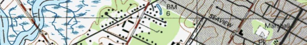
2 I. INTRODUCTION The City of Linwood conducted a study in 2005 to determine the potential traffic impacts of closing the eastern leg of West Avenue at New Road (U.S. Route 9). See Figure 1 for the intersection location. In that study, dated August 16, 2005 prepared by the City Engineer s Office, Concord Atlantic Engineers / Dixon Associates, it was found that the closure of roadway may cause excessive delays and queuing (back-ups) at the adjacent intersection of Seaview Avenue and New Road. It was the Engineer s recommendation that if the City desired to pursue the closure of the street that a temporary closure first be put in place so that the actual impact of the closure could be measured. The report noted that drivers would most likely seek alternate routes rather than accept excessive delays at Seaview Avenue. On the Engineer s recommendation the City of Linwood closed West Avenue between New Road and Mary Jane Lane on January 20, The roadway was reopened on March 3, A second report was issued on March 28, 2005 which contained a detailed traffic analysis of the actual impact of the road closure. During the closure the City of Linwood and its Engineer began considering a number of alternatives in lieu of or in addition to the closure that could make West Avenue in the vicinity of the New Road a safer street for not only the residents in the immediate neighborhood but also for the residents of the City of Linwood as a whole. The following alternatives for the potential closure of West Avenue at New Road were evaluated. Do Nothing Alternative. Permanent Closure of West Avenue. New Road and West Avenue Traffic Signal. New Road and Seaview Avenue Traffic Signal. West Avenue and Seaview Avenue All-Way Stop. West Avenue and Seaview Avenue Change Stop Signs. Realign West Avenue Approach to New Road. Turning Movement Restrictions. Other Alternatives. Concord Atlantic Engineers / Dixon Associates Page 1


3
4 II. DO NOTHING ALTERNATIVE The do nothing alternative is considered here in order to document the positives and negatives of making no improvements to West Avenue. The positives and negatives of this alternative are as follows: A. Positives 1. No traffic increase on other city streets B. Negatives 1. Doing nothing does not address the problem of the vehicles turning from northbound New Road onto West Avenue at higher than acceptable rates of speed. 2. Doing nothing does not address the sight distance deficiencies on the westbound West Avenue approach to New Road that are due to not only objects in the sight triangle but also the inherent problem of an intersection at an extreme acute angle. III. PERMANENT CLOSURE OF WEST AVENUE This alternative involves the permanent closure of West Avenue between New Road and Mary Jane Lane. This alternative was fully evaluated during the temporary closure in January and February It is anticipated that demolition/construction efforts associated with this alternative would be performed by the Department of Public Works. Demolition involves the saw-cutting and removal of a section of paved surface between New Road and West Avenue. Construction also involves only the backfilling, top-soiling, and seeding of the disturbed areas, the installation of appropriate signage, and the striping of the shoulder on New Road. The total anticipated cost for this improvement would be approximately $1,000 for materials including topsoil, seed, and signs. The positives and negatives of this alternative are as follows: A. Positives 1. Elimination of the sight distances issues on West Avenue at New Road. 2. Increased safety of Mary Jane Lane traffic entering West Avenue. 3. Significant decreases in traffic on West Avenue between Seaview Avenue and Forest Drive, potentially including Mainland High School student traffic from Somers Point. Concord Atlantic Engineers / Dixon Associates Page 3
5 4. Potential positive environmental impact from the reduction in impervious surface. 5. Minimal cost of improvements with City Public Works Department involvement in demolition and restoration. 6. Improved access to New Road from the western leg of West Avenue. B. Negatives 1. Traffic volume increases at the intersection of Seaview Avenue and New Road. It is noted that previous studies indicate that the increase in traffic had no significant impact on the operation of the intersection. 2. Minor increases in traffic on Forest Drive. 3. Temporary inconvenience to some residents while seeking alternate routes. IV. NEW ROAD AND WEST AVENUE TRAFFIC SIGNAL A traffic signal warrant analysis was completed in accordance with the Manual of Uniform Traffic Control Devices (MUTCD) 1. In the State of New Jersey, a traffic signal must be warranted by the MUTCD standards. A traffic signal is not warranted at this intersection. Given that a traffic signal is not warranted the New Jersey Department of Transportation will not approve a traffic signal at this location. Warrant Analysis worksheets are provided at the end of this report. V. NEW ROAD AND SEAVIEW AVENUE TRAFFIC SIGNAL A traffic signal warrant analysis was completed in accordance with the Manual of Uniform Traffic Control Devices (MUTCD). In the State of New Jersey a traffic signal must be warranted by the MUTCD standards. A traffic signal is not warranted at this intersection. Given that a traffic signal is not warranted, the New Jersey Department of Transportation will not approve a traffic signal at this location. Warrant Analysis worksheets are provided at the end of this report. 1 Manual of Uniform Traffic Control Devices for Streets and Highways, 2003 Edition, Federal Highway Administration, Washington D.C. Concord Atlantic Engineers / Dixon Associates Page 4
6 It has been suggested that a traffic signal may be warranted at this location when the property directly across from Seaview Avenue on the west side of New Road is developed. This property is part of a redevelopment zone and as such is subject to the City s redevelopment plan. If the City desires a traffic signal at this location, it should consider amending its redevelopment plan to require that the site s main access point be directly across from Seaview Avenue and be signalized. When a redeveloper is chosen, a warrant analysis would then be completed based on the anticipated traffic generation of the new facility. On New Road in the City of Linwood the NJDOT historically requires that traffic signals be spaced a minimum of one-half mile apart. The nearest traffic signal to the south is at Ocean Heights Avenue and to the north is the proposed traffic signal at the Cornerstone Commerce Center. Both locations are greater than one-half mile from Seaview Avenue and it is therefore this office s opinion that should traffic volumes at Seaview Avenue and New Road, with Bloom Site redevelopment traffic added, warrant a traffic signal that it could be approved by the NJDOT. VI. WEST AVENUE AND SEAVIEW AVENUE ALL-WAY STOP An all-way stop control analysis was completed for the intersection of West Avenue and Seaview Avenue. The warrant analysis was completed in accordance with the MUTCD. A full traffic volume based warrant analysis is provided at the end of this report. An all-way stop sign control is not warrant based on traffic volumes or crash history. It has been suggested that the all-way stop sign control at the intersection would help alleviate speeding on West Avenue. The MUTCD specifically states STOP signs should not be used for speed control. As such, Concord Atlantic / Dixon Associates does not recommend the use of stop signs as a method of speed reduction. The MUTCD lists optional criteria that may be considered in an engineering study for determining whether to install all-way stop sign controls. One of these criteria states that all-way stop signs can be considered at Locations where road user, after stopping, cannot see conflicting traffic and is not able to reasonably safely negotiate the intersection unless conflicting cross traffic is also required to stop. Field measurements were taken to determine whether a sight distance deficiency exists at the intersection that could not be reasonably corrected. Table I Concord Atlantic Engineers / Dixon Associates Page 5
7 shows a comparison of the required sight distance triangles versus the actual available sight distance along West Avenue from the Seaview Avenue approaches. As shown in Table I no such sight distance deficiency exists. An all-way stop controlled intersection is not warranted at this location. Approach Seaview Avenue Eastbound Seaview Avenue Eastbound Seaview Avenue Westbound Seaview Avenue Westbound Table I Intersection Sight Distance Requirements Required Sight Actual Sight Looking to Distance 2 Distance Compliant? Right 390 feet 450 feet 3 Yes Left 335 feet > 1,100 feet Yes Right 390 feet >1,100 feet Yes Left 335 feet 470 feet 4 Yes VII. WEST AVENUE AND SEAVIEW AVENUE CHANGE STOP SIGNS It has been suggested that if an all-way stop control was not warranted at the intersection of West Avenue and Seaview Avenue, that the City should remove the stop signs from Seaview Avenue and install them on West Avenue. The idea behind this change was to reduce the speeds on West Avenue. The stop signs as currently installed should remain as is for the following reasons: The MUTCD specifically states STOP signs should not be used for speed control. At an intersection of two similar streets, the street chosen for stop-control is done so by which street has a higher volume of traffic. In the case of this intersection, traffic volumes on West Avenue are higher than those on Seaview Avenue Required intersection distance from, AASHTO, Geometric Design of Highways and Streets, based on a 35 mph design speed. Sight Distance looking right towards New Road is limited only by the intersection of New Road. Sight Distance looking left towards New Road is limited only by the intersection of New Road. Concord Atlantic Engineers / Dixon Associates Page 6
8 Locating stop signs on the higher volume street is recommended at intersections where there is sight distance deficiency on the lower volume street approach to the higher volume street. As noted in Section VI above no such sight distance deficiency exists. VIII. REALIGN WEST AVENUE APPROACH TO NEW ROAD This alternative involves the realignment of the eastern leg of West Avenue at New Road. in lieu of a closure of West Avenue between New Road and Mary Jane Lane. Figure 2 illustrates a conceptual plan for the realignment. This realignment is based on roadway requirements for a residential collector roadway as established by the New Jersey Department of Community Affairs in Residential Site Improvement Standards (RSIS). Concord Atlantic / Dixon Associates considers these requirements to be the minimum acceptable in the design of a roadway. A cost estimate has been prepared and is provided at the end of this report. The cost estimate for construction of these conceptual improvements is approximately $105,000. This cost does not include anticipated costs associated with wetlands mitigation and any associated environmental permitting. The positives and negatives of this realignment alternative are as follows: A. Positives 1. Elimination of the sight distances issues on West Avenue at New Road. 2. Elimination of the high speed northbound New Road right turn onto West Avenue. 3. Minimal (if any) change in the established traffic patterns. 4. Improved access to New Road from the western leg of West Avenue. B. Negatives 1. High Cost 2. Potential infringement on wetlands: This office has identified the triangular piece of property bounded by New Road, West Avenue, and Seaview Avenue as possibly containing wetlands and/or other environmental concerns. It is unlikely that any project that would involve the paving of a wetlands area would receive the support of the Linwood Environmental Commission. Furthermore the Environmental Commission received correspondence from the Greater Egg Harbor Watershed Association stating that no development should occur within this triangular piece of land. Concord Atlantic Engineers / Dixon Associates Page 7
9
10 3. This alternative would create a third street intersection with New Road between Seaview Avenue and the existing western leg of West Avenue. These intersections would be spaced approximately 200 feet apart. IX. TURNING MOVEMENT RESTRICTIONS Various turning movement restrictions at the intersection of West Avenue and New Road have been suggested both as stand alone and in combination as follows: A. No Right Turn from Northbound New Road onto West Avenue: This restriction would eliminate the high speed turning movement onto West Avenue; however, it would not solve the southbound West Avenue sight distance problems inherent with the intersection s tight angle. B West Avenue One-Way Northbound Between Mary Jane Lane and New Road: This restriction would eliminate the high speed turning movement onto West Avenue; however, it would not solve the southbound West Avenue sight distance problems inherent with the intersections tight angle. C. No Left Turn from West Avenue south onto to New Road. This restriction would partially eliminate the southbound West Avenue sight distance problems inherent with the intersection s tight angle, but would do nothing to solve high speed turning movement onto West Avenue. This type of restriction could cause further confusion as drivers would not know until they get to the intersection that they may not turn left. D. West Avenue One-Way Southbound Between Mary Jane Lane and New Road: This restriction would eliminate the southbound West Avenue sight distance problems inherent with the intersection s tight angle, but would do nothing to solve high speed turning movement onto West Avenue. Concord Atlantic Engineers / Dixon Associates Page 9
11 E. Combination of A and C Above These two restrictions would have nearly the same effect as the temporary road closure given that the two movements being restricted represent more than 85 percent of the turning movements at the intersection. X. OTHER ALTERNATIVES The following alternatives are based in part on suggestions from residents of the City of Linwood as a means to make West Avenue safer without closing West Avenue permanently. A. Install a Flashing Beacon Above the Existing West Avenue Stop Sign at New Road. This alternative involves the installation of a flashing beacon above the stop sign on the westbound approach of West Avenue to New Road. This alternative would provide little benefit with regards to the traffic safety at the intersection and would cost several thousand dollars. These types of devices are typically installed at locations where the driver does not expect to have to stop. There is no evidence that this condition exists. B. Install a Hidden Driveway Sign with a Flashing Beacon on New Road: This improvement was suggested as a means to warn drivers on New Road who are turning onto West Avenue that a hidden driveway, Mary Jane Lane, exists. The suggestion was that the sign would advise drivers to slow down while making the turn. This type of sign with or without the beacon is intended to warn drivers traveling on the road on which the device is installed that a hidden driveway exists on that road. Since the driveway in question, Mary Jane Lane, is located on West Avenue this device would not be appropriate on New Road. Furthermore, the device would not be appropriate on West Avenue given not only Mary Jane Lane s location with respect to New Road, but also due to the fact that Mary Jane Lane is not actually hidden from drivers on West Avenue. C. Install a No Left Turn Sign on Mary Jane Lane at West Avenue. Installing such a traffic control device would force residents on Mary Jane Lane to turn right onto West Avenue. The risk would still exist of those residents being involved in a rear end collision from a vehicle turning right onto West Avenue from northbound New Road. Other Concord Atlantic Engineers / Dixon Associates Page 10
12 traffic control devices are not warranted based on previous discussion contained herein. Therefore the alternative provides little benefit D. Increase Visibility from West Avenue and Mary Jane Lane at New Road. Improving and maintaining adequate sight triangles should be done at all intersections in the City of Linwood. At this intersection these improvements would not effectively mitigate the high speed right turn from northbound New Road onto West Avenue. Additionally the difficulty in looking north onto New Road from the eastern leg of West Avenue is not addressed by sight triangle clearing alone. E. Paint Crosswalks at Seaview Avenue and West Avenue Intersection. A review of this suggested alternative indicates that crosswalks should be considered at the intersection. While these improvements would not improve conditions at New Road and West Avenue nor address the safety concerns at that intersection, the crosswalks may help to slow down the vehicles as they approach the intersection of Seaview Avenue and West Avenue. XI. CONCLUSIONS Given the positives and negatives of each viable alternative, Concord Atlantic Engineers / Dixon Associates has found through this study that the permanent closure of the West Avenue between New Road and Mary Jane Lane is the best alternative to effectively improve traffic safety on West Avenue. Through both Parts II and III of the West Avenue and New Road Traffic Study, it has been demonstrated that the permanent closure will have a minimal impact on other roads in the area. Should the City of Linwood desire to move forward with the closure of West Avenue a demolition plan would be required and a street improvement application made to the New Jersey Department of Transportation. If the closure is put permanently into place the stop signs at the intersection of Seaview Avenue and West Avenue should be removed from the Seaview Avenue approaches and installed on the West Avenue approaches. It will also be necessary to remove the painted stop bars from Seaview Avenue. Concord Atlantic Engineers / Dixon Associates Page 11
13 Concord Atlantic / Dixon Associates recommends that should the City move forward with the closure that intersection improvements including drainage at the intersection of New Road and Seaview Avenue also be considered. Regardless of whether the subject section of West Avenue is closed, the sight triangle at the intersection of New Road and Seaview Avenue should be cleared. This would involve the removal of some trees and brush to improve the sight lines at the intersection. Concord Atlantic Engineers / Dixon Associates Page 12
14 APPENDIX A Traffic Signal Warrant Analysis Worksheets Concord Atlantic Engineers / Dixon Associates
15 APPENDIX B All-Way Stop Sign Control Warrant Analysis Concord Atlantic Engineers / Dixon Associates
16 APPENDIX C West Avenue Realignment Cost Estimate Concord Atlantic Engineers / Dixon Associates
Access Location, Spacing, Turn Lanes, and Medians
 Design Manual Chapter 5 - Roadway Design 5L - Access Management 5L-3 Access Location, Spacing, Turn Lanes, and Medians This section addresses access location, spacing, turn lane and median needs, including
A plan for improved motor vehicle access on Railroad Avenue in Provincetown
 A plan for improved motor vehicle access on Railroad Avenue in Provincetown February 2011 A plan for improved motor vehicle access on Railroad Avenue in Provincetown INTRODUCTION AND PROBLEM IDENTIFICATION
ORANGE COUNTY PUBLIC WORKS TRAFFIC INVESTIGATIONS
 ORANGE COUNTY PUBLIC WORKS TRAFFIC INVESTIGATIONS STAFF REPORT OF: January 6, 2019 SUPERVISORIAL DISTRICT: 5 SUBJECT: LOCATION: INVESTIGATOR: O Neill Drive at Roanoke Drive; Ladera Ranch; TB 922-E6 Clever
TRAFFIC SIGNAL WARRANT STUDY
 TRAFFIC SIGNAL WARRANT STUDY 5 th STREET & ENCHANTED PINES DRIVE JANUARY 2013 TRAFFIC OPERATIONS ENGINEERING SERVICES/PUBLIC WORKS DEPARTMENT TABLE OF CONTENTS INTERSECTION LOCATION MAP ii INTRODUCTION
TRAFFIC CONTROL DEVICES ON EDGEWATER BOULEVARD AT PORT ROYAL AVENUE (NORTH)
") Attachment 2 DATE: August 6, 2012 TO: VIA: FROM: SUBJECT: Mayor and Members of the City Council James C. Hardy, City Manager Ramon Towne, Director of Public Works Leah Edwards, Assistant Engineer TRAFFIC
Attachment 2 DATE: August 6, 2012 TO: VIA: FROM: SUBJECT: Mayor and Members of the City Council James C. Hardy, City Manager Ramon Towne, Director of Public Works Leah Edwards, Assistant Engineer TRAFFIC
133 rd Street and 132 nd /Hemlock Street 132 nd Street and Foster Street MINI ROUNDABOUTS. Overland Park, Kansas
 133 rd Street and 132 nd /Hemlock Street 132 nd Street and Foster Street MINI ROUNDABOUTS Overland Park, Kansas September 1, 2017 TABLE OF CONTENTS 1. INTRODUCTION... 1 2. LITERATURE REVIEW... 1 3. CONCEPT
Glenn Avenue Corridor Traffic Operational Evaluation
 Glenn Avenue Corridor Traffic Operational Evaluation PREPARED FOR: THE CITY OF AUBURN PREPARED BY: DECEMBER 2007 Glenn Avenue Corridor Study--Auburn, Alabama TABLE OF CONTENTS Introduction... 1 Background
Caltrans Sloat Boulevard Pedestrian Safety Project Response to Community Questions, Comments & Concerns
 Caltrans Sloat Boulevard Pedestrian Safety Project Response to Community Questions, Comments & Concerns Revised: May 10, 2016 The California Department of Transportation (Caltrans) is planning various
INTERSECTION SAFETY STUDY State Route 57 / Seville Road
 INTERSECTION SAFETY STUDY State Route 57 / Seville Road City of Wadsworth, Medina County, Ohio Prepared For: City of Wadsworth Engineering Department 120 Maple Street Wadsworth, OH 44281 Prepared By: GPD
Swamp Road Residents Study
 Swamp Road Residents Study SRRG Meeting with PennDot and Elected Officials Newtown and Wrightstown, PA April 25, 2008 Newtown Township Section of Swamp Road Limited Public Funds No reconstruction of a
Project Report. South Kirkwood Road Traffic Study. Meadows Place, TX October 9, 2015
 Meadows Place, TX October 9, 2015 Contents 1 Introduction... 1 2 Data Collection... 1 3 Existing Roadway Network... 2 4 Traffic Volume Development... 2 5 Warrant Analysis... 3 6 Traffic Control Alternative
Traffic Impact Analysis Walton Acres at Riverwood Athletic Club Clayton, NC
 Traffic Impact Analysis Walton Acres at Riverwood Athletic Club Clayton, NC 1. TABLE OF CONTENTS INTRODUCTION...1 1.1. Site Location and Study Area...1 1.2. Proposed Land Use and Site Access...2 1.3.
City of Albert Lea Policy and Procedure Manual 4.10 ALBERT LEA CROSSWALK POLICY
 4.10 ALBERT LEA CROSSWALK POLICY PURPOSE: Pedestrian crosswalks are an integral part of our transportation infrastructure. To be effective and promote safety, marked crosswalks must be installed after
Orange Center Elementary School
 Drag and drop pic and stretch/crop to the limits of the blue rectangle (delete this text box) Orange Center Elementary School Drag and drop pic and stretch/crop to the limits of the blue rectangle (delete
TRAFFIC STUDY. Birch Bluff Road / Pleasant Avenue 01/15/2018. City of Tonka Bay 4901 Manitou Road Tonka Bay, MN WSB PROJECT NO.
 TRAFFIC STUDY Birch Bluff Road / Pleasant Avenue 01/15/2018 City of Tonka Bay 4901 Manitou Road Tonka Bay, MN 55331 WSB PROJECT NO. 10805-000 Birch Bluff Road/ Pleasant Avenue Traffic Study For: City of
Capital Region Council of Governments
 March 23, 2018 Capital Region Council of Governments PROJECT CONCEPT REPORT Realignment of Swamp and Northfield Road s approaches to Route 44 (Boston Turnpike) Town of Coventry SUMMARY: The Town of Coventry
Appendix B. Environmental Resource Technical Memorandum. Assessment on Travel Pattern and Access Impacts
 Appendix B Environmental Resource Technical Memorandum Assessment on Travel Pattern and Access Impacts TECHNICAL MEMORANDUM ENVIRONMENTAL RE-EVALUATION FOR UNION STATION TO OAK CLIFF DALLAS STREETCAR To:
Traffic Impact Study. Westlake Elementary School Westlake, Ohio. TMS Engineers, Inc. June 5, 2017
 TMS Engineers, Inc. Traffic Impact Study Westlake Elementary School Westlake, Ohio June 5, 2017 Prepared for: Westlake City Schools - Board of Education 27200 Hilliard Boulevard Westlake, OH 44145 TRAFFIC
Public Involvement Outreach Requirements for Public Information Open House Meeting: C.N , HSIP-5003(12) 132 nd and West Center Road, Omaha
 132 nd and West Center Road, Omaha") To: NDOR Environmental From: Randy McCart, HDR Date: 4 April 2017 RE: Public Involvement Summary Report, HSIP-5003(12) 132 nd and West Center Road, Omaha; C.N. 22629 Public Involvement Outreach Requirements
To: NDOR Environmental From: Randy McCart, HDR Date: 4 April 2017 RE: Public Involvement Summary Report, HSIP-5003(12) 132 nd and West Center Road, Omaha; C.N. 22629 Public Involvement Outreach Requirements
CONTENTS EXECUTIVE SUMMARY 1
 CONTENTS CHAPTER PAGE EXECUTIVE SUMMARY 1 1 ISSUES AND PURPOSE OF THE ANALYSIS 2 1.1 Background 2 1.2 Analysis Area 2 1.3 Issues and Observations 3 1.4 Project and Public Meetings 3 2 LIST OF PREFERRED
Hidden Oaks Elementary School
 Hidden Oaks Elementary School SCHOOL ROUTE PLAN For HIDDEN OAKS ELEMENTARY SCHOOL LOCATION 13 ORANGE COUNTY Prepared for: ORANGE COUNTY SCHOOL ASSESSMENT PROGRAM ORANGE COUNTY PUBLIC WORKS Traffic Engineering
Readington Road (C.R. 637) Construction
 Construction") Public Information Meeting Thursday, August 2, 2012 Readington Road (C.R. 637) Construction from Dreahook Road to Harlan School Road Branchburg Township, Somerset County Readington Township, Hunterdon
Public Information Meeting Thursday, August 2, 2012 Readington Road (C.R. 637) Construction from Dreahook Road to Harlan School Road Branchburg Township, Somerset County Readington Township, Hunterdon
Date: April 4, Project #: Re: A Street/Binford Street Traffic/Intersection Assessment
 To: Peter Cavanaugh General Electric From: David Bohn, PE Ryan White, PE Date: April 4, 217 Project #: 13421. Re: / Traffic/Intersection Assessment Consistent with the Cooperation Agreement between the
TRAFFIC ACTION PLAN. Laurie Meadows Neighborhood CITY OF SAN MATEO
 TRAFFIC ACTION PLAN Laurie Meadows Neighborhood CITY OF SAN MATEO Draft January 2017 Table of Contents Introduction... 2 The Traffic Forum Process... 5 Neighborhood Traffic Issues... 7 Neighborhood Recommendations
Transportation Impact Study for Abington Terrace
 Transportation Impact Study for Abington Terrace Abington Township, Montgomery County, PA Sandy A. Koza, P.E., PTOE PA PE License Number PE059911 Prepared by McMahon Associates, Inc. 425 Commerce Drive,
Overview. Updated pictures of the intersection are shown in Exhibits 1 thru 4, and the aerial photo provided by Google Maps is shown in Exhibit 5.
 Overview The (here in after referred to as the Village ) is submitting the follow up interim RLRC Safety Report for the intersection of Lincoln Highway (US 30) at Orchard Drive. Additional reports, as
Windy Ridge Elementary School
 Windy Ridge Elementary School SCHOOL ROUTE PLAN For WINDY RIDGE ELEMENTARY SCHOOL LOCATION 54 ORANGE COUNTY Prepared for: ORANGE COUNTY SCHOOL ASSESSMENT PROGRAM ORANGE COUNTY PUBLIC WORKS Traffic Engineering
WISCONSIN AVENUE EXTENSION SECOND PUBLIC INFORMATION MEETING. March 28, 2017
 WISCONSIN AVENUE EXTENSION SECOND PUBLIC INFORMATION MEETING March 28, 2017 STUDY AREA N MEETING AGENDA Introductions Study Background Alternatives Studied Recommended Alternative Discussion STUDY BACKGROUND
Figure 1: Vicinity Map of the Study Area
 ARIZONA TEXAS NEW MEXICO OKLAHOMA May 5, 2016 Mr. Anthony Beach, P.E. BSP Engineers 4800 Lakewood Drive, Suite 4 Waco, Texas 76710 Re: Intersection and Access Analysis along Business 190 in Copperas Cove
Route 28 (South Orleans Road)/Route 39 (Harwich Road)/Quanset Road Intersection
/Route 39 (Harwich Road)/Quanset Road Intersection") TRAFFIC FEASIBILITY STUDY Route 28 (South Orleans Road)/Route 39 (Harwich Road)/Quanset Road Intersection Orleans, Massachusetts Prepared for: Town of Orleans Prepared by: Fay, Spofford & Thorndike, LLC
TRAFFIC FEASIBILITY STUDY Route 28 (South Orleans Road)/Route 39 (Harwich Road)/Quanset Road Intersection Orleans, Massachusetts Prepared for: Town of Orleans Prepared by: Fay, Spofford & Thorndike, LLC
TRAFFIC IMPACT STUDY And A TRAFFIC SIGNAL WARRANT ANALYSIS FOR A SENIOR LIVING AND APARTMENT DEVELOPMENT
 TRAFFIC IMPACT STUDY And A TRAFFIC SIGNAL WARRANT ANALYSIS FOR A SENIOR LIVING AND APARTMENT DEVELOPMENT DEERFIELD TOWNSHIP, WARREN COUNTY, OHIO Nantucket Circle and Montgomery Road () Prepared for: ODLE
Truck Climbing Lane Traffic Justification Report
 ROUTE 7 (HARRY BYRD HIGHWAY) WESTBOUND FROM WEST MARKET STREET TO ROUTE 9 (CHARLES TOWN PIKE) Truck Climbing Lane Traffic Justification Report Project No. 6007-053-133, P 101 Ι UPC No. 58599 Prepared by:
ALLEY 24 TRAFFIC STUDY
 ALLEY 24 TRAFFIC STUDY in City of Frostburg, Maryland January 2013 3566 Teays Valley Road Hurricane, WV Office: (304) 397-5508 www.denniscorporation.com Alley 24 Traffic Study January 2013 Frostburg, Maryland
TRAFFIC IMPACT ANALYSIS
 TRAFFIC IMPACT ANALYSIS FOR THE CHAMPAIGN UNIT#4 SCHOOL DISTRICT PROPOSED HIGH SCHOOL (SPALDING PARK SITE) IN THE CITY OF CHAMPAIGN Final Report Champaign Urbana Urbanized Area Transportation Study 6/24/2014
Traffic Study of Fuller Street, Cady Street, West Street and West Avenue. Final Report
 Traffic Study of Fuller Street, Cady Street, West Street and West Avenue Final Report July 2005 Prepared for: Town of Ludlow Prepared by: Pioneer Valley Planning Commission 26 Central Street West Springfield,
Existing Conditions. Date: April 16 th, Dan Holderness; Coralville City Engineer Scott Larson; Coralville Assistant City Engineer
 Date: April 16 th, 2015 To: From: Re: Dan Holderness; Coralville City Engineer Scott Larson; Coralville Assistant City Engineer Darian Nagle-Gamm, Traffic Engineering Planner Highway 6 (2 nd Street) /
Corporate. Report COUNCIL DATE: May 25, 1998 NO: R1500 REGULAR COUNCIL. TO: Mayor & Council DATE: April 27, 1998
 R1500 : Traffic Safety at 25 Avenue and 128 Street Intersection Corporate NO: R1500 Report COUNCIL DATE: May 25, 1998 REGULAR COUNCIL TO: Mayor & Council DATE: April 27, 1998 FROM: General Manager, Engineering
Roundabouts are good for business
 Roundabouts are good for business What is a roundabout Rules 0f Roundabouts 1. Slow down when approaching a roundabout 2. Yield to vehicles in the roundabout 3. When clear, proceed right into the roundabout
ORANGE COUNTY TRAFFIC COMMITTEE. Intersection Control. Constituent. Deepthi Arabolu. Relocate Stop Sign
 ORANGE COUNTY TRAFFIC COMMITTEE SUPERVISORIAL DISTRICT: 3 SUBJECT: Intersection Control LOCATION: Browning Avenue at Rainbow Drive; North Tustin; TB 830-E3 INITIATED BY: INVESTIGATOR: REQUEST: Constituent
Table of Contents FIGURES TABLES APPENDICES. Traffic Impact Study Hudson Street Parking Garage MC Project No.: A Table of Contents
 Traffic Impact Study Hudson Street Parking Garage MC Project No.: 151714A Table of Contents Table of Contents I. INTRODUCTION... 2 II. EXISTING CONDITIONS... 5 III. 215 EXISTING TRAFFIC CONDITIONS... 6
Designing for Pedestrian Safety. Alabama Department of Transportation Pre-Construction Conference May 2016
 Designing for Pedestrian Safety Alabama Department of Transportation Pre-Construction Conference May 2016 1 Designing for Pedestrians Marking Crosswalks at Signalized intersections High Visibility Markings
DIMARCO CANANDAIGUA PROPERTIES HOUSING PROJECT CANANDAIGUA, ONTARIO COUNTY, NEW YORK
 TRAFFIC IMPACT STUDY FOR THE DIMARCO CANANDAIGUA PROPERTIES HOUSING PROJECT CANANDAIGUA, ONTARIO COUNTY, NEW YORK MARCH 14, 2017 PREPARED FOR: 1950 Brighton Henrietta Town Line Rd Rochester, NY 14623 PREPARED
Driveway Design Criteria
 Design Manual Chapter 5 - Roadway Design 5L - Access Management 5L-4 Driveway Design Criteria A. General For efficient and safe operations, access drives and minor public street intersections can be improved
Traffic Impact Analysis Chatham County Grocery Chatham County, NC
 Chatham County Grocery Chatham County, NC TABLE OF CONTENTS 1. INTRODUCTION... 1 1.1. Location and Study Area... 1 1.2. Proposed Land Use and Access... 2 1.3. Adjacent Land Uses... 2 1.4. Existing ways...
Traffic Analysis and Design Report. NW Bethany Boulevard. NW Bronson Road to NW West Union Road. Washington County, Oregon
 Traffic Analysis and Design Report NW Bethany Boulevard NW Bronson Road to NW West Union Road Washington County, Oregon May 2011 Table of Contents Table of Contents Section 1 Executive Summary... 2 Section
DEPARTMENT OF ENVIRONMENTAL SERVICES. North Harrison Street (Lee Highway to Little Falls Road) Comparative Analysis. Prepared for:
 Comparative Analysis. Prepared for:") DEPARTMENT OF ENVIRONMENTAL SERVICES North Harrison Street (Lee Highway to Little Falls Road) Comparative Analysis Prepared for: Arlington County Department of Environmental Services 2100 Clarendon Boulevard,
DEPARTMENT OF ENVIRONMENTAL SERVICES North Harrison Street (Lee Highway to Little Falls Road) Comparative Analysis Prepared for: Arlington County Department of Environmental Services 2100 Clarendon Boulevard,
MEMORANDUM. Nantasket Road at Kingsley Road Kingsley Road at Sumner Street Kingsley Road at Revere Street Kingsley Road at Kenberma Street
 MEMORANDUM Date: June 28, 2012 To: From: Subject: Mr. Joseph Stigliani, Director of Public Works Kenneth J. Petraglia, P.E., PTOE Greg E. Lucas, P.E., PTOE Kingsley Road Stop Sign Warrant Analysis BETA
Chapter Twenty-eight SIGHT DISTANCE BUREAU OF LOCAL ROADS AND STREETS MANUAL
 Chapter Twenty-eight SIGHT DISTANCE BUREAU OF LOCAL ROADS AND STREETS MANUAL Jan 2006 SIGHT DISTANCE 28(i) Chapter Twenty-eight SIGHT DISTANCE Table of Contents Section Page 28-1 STOPPING SIGHT DISTANCE
METHODOLOGY. Signalized Intersection Average Control Delay (sec/veh)
") Chapter 5 Traffic Analysis 5.1 SUMMARY US /West 6 th Street assumes a unique role in the Lawrence Douglas County transportation system. This principal arterial street currently conveys commuter traffic
Chapter 5 Traffic Analysis 5.1 SUMMARY US /West 6 th Street assumes a unique role in the Lawrence Douglas County transportation system. This principal arterial street currently conveys commuter traffic
EXHIBIT ''A'' INDIAN RIVER COUNTY PUBLIC WORKS DEPARTMENT TRAFFIC ENGINEERING DIVISION TRAFFIC CONTROL DEVICES MAINTAINED BY INDIAN RIVER COUNTY
 EXHIBIT ''A'' INDIAN RIVER COUNTY JULY,2016 TABLE OF CONTENTS Traffic Signals... Page 2 Flashing Beacons... Page 6 20 M.P.H. School Flashing Beacons... Page 7 Speed Warning/Driver Feedback Signs... Page
Walton Acres at Riverwood Athletic Club Clayton, North Carolina
 9. CONCLUSIONS This Traffic Impact Analysis Update was conducted to determine the potential traffic impacts of the proposed Walton Acres at Riverwood Athletic Club residential development, located east
Broadway Street Pedestrian Safety Study Cass Street to 700 Feet North of Randall Avenue
 Broadway Street Pedestrian Safety Study Cass Street to 700 Feet North of Randall Avenue Prepared for: City of De Pere, Wisconsin Prepared by: June, 2017 Broadway Street Pedestrian Safety Study Cass Street
2007 TRAFFIC SIGNAL PRIORITY LIST SUMMARY OF STAFF RECOMMENDATIONS TO PEDESTRIAN/BICYCLE/MOTOR VEHICLE COMMISSION.
 Traffic Engineering and Parking Divisions David C. Dryer, City Traffic Engineer and Parking Manager 215 Martin Luther King, Jr. Boulevard P.O. Box 2986 Madison, Wisconsin 53701-2986 Phone 608 266 4761
Traffic Circulation Study for Neighborhood Southwest of Mockingbird Lane and Airline Road, Highland Park, Texas
 ARIZONA TEXAS NEW MEXICO OKLAHOMA February 13, 2015 Mr. Meran Dadgostar P.E., R.S. Town of Highland Park 4700 Drexel Dr. Highland Park, Texas 75205 Re: Traffic Circulation Study for Neighborhood Southwest
1609 E. FRANKLIN STREET HOTEL TRAFFIC IMPACT STUDY EXECUTIVE SUMMARY
 1609 E. FRANKLIN STREET HOTEL TRAFFIC IMPACT STUDY EXECUTIVE SUMMARY Prepared for: The Town of Chapel Hill Public Works Department Traffic Engineering Division Prepared by: HNTB North Carolina, PC 343
DRAFT. A fifth objective, other considerations, has been added to capture considerations not captured by the four primary objectives.
 TECHNICAL MEMORANDUM Albany - Washington Avenue Traffic Calming Evaluation Matrix of Conceptual Alternatives Date: May 17, 2017 Project #: 17356 To: Aleida Andrino-Chavez From: Laurence Lewis, Sara Muse,
SCHOOL ROUTE PLAN. For HUNTER S CREEK ELEMENTARY SCHOOL LOCATION 14 ORANGE COUNTY. Prepared for:
 SCHOOL ROUTE PLAN For HUNTER S CREEK ELEMENTARY SCHOOL LOCATION 14 ORANGE COUNTY Prepared for: ORANGE COUNTY SCHOOL ASSESSMENT PROGRAM ORANGE COUNTY PUBLIC WORKS Traffic Engineering Division 42 South John
Proposed changes to Massachusetts MUTCD Supplement
 Proposed changes to Massachusetts MUTCD Supplement John F. Carr National Motorists Association October 24, 2002 This document contains recommendations as to the contents of the Massachusetts MUTCD supplement
Evaluation of M-99 (Broad Street) Road Diet and Intersection Operational Investigation
 Road Diet and Intersection Operational Investigation") Evaluation of M-99 (Broad Street) Road Diet and Intersection Operational Investigation City of Hillsdale, Hillsdale County, Michigan June 16, 2016 Final Report Prepared for City of Hillsdale 97 North Broad
Evaluation of M-99 (Broad Street) Road Diet and Intersection Operational Investigation City of Hillsdale, Hillsdale County, Michigan June 16, 2016 Final Report Prepared for City of Hillsdale 97 North Broad
Lake Whitney Elementary School
 Lake Whitney Elementary School SCHOOL ROUTE PLAN For LAKE WHITNEY ELEMENTARY SCHOOL LOCATION 18 ORANGE COUNTY Prepared for: ORANGE COUNTY SCHOOL ASSESSMENT PROGRAM ORANGE COUNTY PUBLIC WORKS Traffic Engineering
Washington St. Corridor Study
 FIGURE 7.17 Bridge Alternatives - Cross Sections 86 Discarded Alternative: Short-Term Bridge Repair Short-term repairs and west bridge span replacement were considered during analysis. Short-term repairs
Intersection Traffic Control Feasibility Study
 Intersection Traffic Control Feasibility Study CSAH 9 at CSAH 60 (185th Avenue) Prepared For: Dakota County Transportation Department Western Service Center 14955 Galaxie Avenue, 3rd Floor Apple Valley,
POLICY FOR NEIGHBORHOOD TRAFFIC CALMING
 POLICY FOR NEIGHBORHOOD TRAFFIC CALMING I. STATEMENT OF PURPOSE This policy provides a procedure for the consideration, evaluation and implementation of requests for traffic calming measures. II. DEFINITIONS
List of Attachments. Location Map... Site Plan... City of Lake Elsinore Circulation Element... City of Lake Elsinore Roadway Cross-Sections...
 List of Attachments Exhibits Location Map... Site Plan... City of Lake Elsinore Circulation Element... City of Lake Elsinore Roadway Cross-Sections... Existing Lane Geometry and Traffic Controls... Existing
WELCOME Public Information Centre
 WELCOME Public Information Centre Fernforest Drive Brampton Soccer Centre Community Room #2 Tuesday January 19, 2016 6:30 p.m.to 9:00 p.m. Please sign in Neighbourhood Traffic Calming Guide Background
Appendix C. TRAFFIC CALMING PROGRAM TOOLBOX
 Appendix C. TRAFFIC CALMING PROGRAM TOOLBOX PHASE I...2 Do Not Enter Sign...3 One-Way Sign...4 Turn Prohibition...5 Pavement Markings...6 Speed Monitoring Trailer...7 Neighborhood Speed Watch...8 Police
MEMORANDUM. Charlotte Fleetwood, Transportation Planner
 MEMORANDUM Date: Updated August 22, 2017 To: Organization: Charlotte Fleetwood, Transportation Planner Boston Transportation Department From: Jason DeGray, P.E., PTOE, Regional Director of Engineering
AGENDA ITEM 6 D THOMASVILLE ROAD (HERMITAGE BOULEVARD TO LIVE OAK PLANTATION ROAD) ROADWAY SAFETY AUDIT
 ROADWAY SAFETY AUDIT") May 15, 2018 AGENDA ITEM 6 D THOMASVILLE ROAD (HERMITAGE BOULEVARD TO LIVE OAK PLANTATION ROAD) ROADWAY SAFETY AUDIT TYPE OF ITEM: Discussion STATEMENT OF ISSUE The Florida Department of Transportation
May 15, 2018 AGENDA ITEM 6 D THOMASVILLE ROAD (HERMITAGE BOULEVARD TO LIVE OAK PLANTATION ROAD) ROADWAY SAFETY AUDIT TYPE OF ITEM: Discussion STATEMENT OF ISSUE The Florida Department of Transportation
CITY OF COCONUT CREEK IMPLEMENTATION GUIDELINES FOR TRAFFIC CALMING
 CITY OF COCONUT CREEK IMPLEMENTATION GUIDELINES FOR TRAFFIC CALMING I. Introduction: The City of Coconut Creek recognizes that the conditions of residential streets can greatly affect neighborhood livability;
CITY OF BEVERLY HILLS
 LL5 CITY OF BEVERLY HILLS TRAFFIC & PARKING COMMISSION Meeting of December 1, 2076 TO: FROM: SUBJECT: ATTACHMENTS: Traffic and Parking Commission Bijan Vaziri P.T.E., Traffic Engineer Request for an All-Way
Town of Clarkstown Traffic Calming Program. Table of Contents
 Town of Clarkstown Traffic Calming Program Table of Contents I. INTRODUCTION a. Purpose & Intent b. Key to Successful Projects c. What is Traffic Calming? II. Definitions III. Street Classification IV.
Joshua Jester, E.I., Florida Department of Transportation, District One
 MEMORANDUM To: From: Joshua Jester, E.I., Florida Department of Transportation, District One Michael Garau, P.E., Kimley-Horn and Associates, Inc. Date: October 5, 2018 Subject: at Gulfstream Avenue Intersection
DRAFT. Corridor study. Honeysuckle Road. October Prepared for the City of Dothan, AL. Prepared by Gresham, Smith and Partners
 DRAFT Corridor study Honeysuckle Road October 2017 Prepared for the City of Dothan, AL Prepared by TABLE OF CONTENTS SECTION I... 1 STUDY SUMMARY... 1 INTRODUCTION... 1 CONCLUSIONS... 5 SECTION II... 7
CONTENTS EXECUTIVE SUMMARY. 1 SUMMARY OF EXISTING CONDITIONS Issues and Observations Public Meeting (December 2005) 1
 1") CONTENTS CHAPTER PAGE EXECUTIVE SUMMARY ES-1 1 SUMMARY OF EXISTING CONDITIONS 1 1.1 Issues and Observations 1 1.2 Public Meeting (December 2005) 1 2 LIST OF POTENTIAL IMPROVEMENT STRATEGIES 2 2.1 Traffic
CONTENTS CHAPTER PAGE EXECUTIVE SUMMARY ES-1 1 SUMMARY OF EXISTING CONDITIONS 1 1.1 Issues and Observations 1 1.2 Public Meeting (December 2005) 1 2 LIST OF POTENTIAL IMPROVEMENT STRATEGIES 2 2.1 Traffic
Interstate Route 77 / US Route 62 / State Route 687 (Fulton Road) Transportation Improvement Project. Prepared September 6, 2017
 Transportation Improvement Project. Prepared September 6, 2017") EODOT Project: ODOT Project: STA-IR 77-.50; PID 00290 Interstate Route 77 / US Route 62 / State Route 687 (Fulton Road) Transportation Improvement Project Summary of Public Comments Received and Responses
EODOT Project: ODOT Project: STA-IR 77-.50; PID 00290 Interstate Route 77 / US Route 62 / State Route 687 (Fulton Road) Transportation Improvement Project Summary of Public Comments Received and Responses
TRAFFIC IMPACT STUDY. Creekside Thornton, Colorado. For. August 2015 November 2015 Revised: August Prepared for:
 TRAFFIC IMPACT STUDY For Creekside Thornton, Colorado August 215 November 215 Revised: August 216 Prepared for: Jansen Strawn Consulting Engineers 45 West 2 nd Avenue Denver, Colorado 8223 Prepared by:
CITY OF WEST LAKE HILLS. Forest View Neighborhood Traffic Calming Study
 CITY OF WEST LAKE HILLS 901 South Mopac Expressway Building V, Suite 220 Austin, Texas 78746 Texas P.E. Firm Registration No. F-929 Klotz Associates Final Report Submittal: March 20, 2015 Revised Final
ROUTE 22 CORRIDOR STUDY: CORRIDOR MANAGEMENT PLAN APPENDIX A A-12
 ROUTE 22 CORRIDOR STUDY: CORRIDOR MANAGEMENT PLAN APPENDIX A A-12 3.0 HARLEM VALLEY TRANSPORTATION PLAN Incorporates transportation systems management and safety improvements. Location: Route 22 corridor
CITY OF SASKATOON COUNCIL POLICY
 ORIGIN/AUTHORITY Clause 1, Report No. 1-1980 and Clause 4, Report No. 22-1990 of the Works and Utilities Committee; Clause 6, Report No. 17-2004 of the Planning and Operations Committee; and Clause D5,
STILLWATER AVENUE CORRIDOR STUDY Old Town, Maine
 Draft Study STILLWATER AVENUE CORRIDOR STUDY Old Town, Maine SUBMITTED TO: BANGOR AREA COMPREHENSIVE TRANSPORTATION SYSTEM SUBMITTED BY: I MAY 23, 2017 DRAFT STILLWATER AVENUE STUDY FINAL REPORT Table
Southside Road. Prepared for: City of St. John s Police & Traffic Committee. Prepared by: City of St. John s Traffic Division
 Southside Road Prepared for: City of St. John s Police & Traffic Committee Prepared by: City of St. John s Traffic Division January 2007 Southside Road - Traffic Report Page 1 of 9 BACKGROUND: th At the
City of Prince Albert Statement of POLICY and PROCEDURE. Department: Public Works Policy No. 66. Section: Transportation Issued: July 14, 2014
 Page: 1 of 8 1 POLICY 1.01 The City shall follow all of the specifications in the Manual of Uniform Traffic Control Devices for Canada, prepared by the National Committee of Uniform Traffic Control, and
MEMORANDUM TERESA MCCLISH, COMMUNITY DEVELOPMENT DIRECTOR SUBJECT: CONSIDERATION OF RESTRICTING PARKING ADJACENT TO 170 AND 171 BRISCO ROAD
 MEMORANDUM TO: FROM: BY: TRAFFIC COMMISSION TERESA MCCLISH, COMMUNITY DEVELOPMENT DIRECTOR MATT HORN, CITY ENGINEER SUBJECT: CONSIDERATION OF RESTRICTING PARKING ADJACENT TO 170 AND 171 BRISCO ROAD DATE:
Table 1. Greatest Reductions in Traffic Volume
 Interstate MAX Light Rail Traffic Impact Summary Portland Office of Transportation October 2005 Summary The majority of streets after construction of the Interstate MAX light rail extension experienced
Roads that are intended to be included in the VDOT system of maintained roadways must meet the standards and specifications prescribed by the VDOT.
 SECTION 1 - GENERAL 1-1 Purpose This Manual has been prepared to promote uniform design procedures for designers and technicians in the development of property and roads in the County of Henrico, Virginia.
TOWN OF PAYSON TRAFFIC CALMING MANUAL
 TOWN OF PAYSON TRAFFIC CALMING MANUAL APPROVED BY THE PAYSON TOWN COUNCIL SEPTEMBER 6, 2007 TOWN OF PAYSON TRAFFIC CALMING POLICY 1.0 Introduction Traffic Calming involves retrofitting physical devices
Durrance Elementary School
 Durrance Elementary School SCHOOL ROUTE PLAN For DURRANCE ELEMENTARY SCHOOL LOCATION 9 ORANGE COUNTY Prepared for: ORANGE COUNTY SCHOOL ASSESSMENT PROGRAM ORANGE COUNTY PUBLIC WORKS Traffic Engineering
Traffic Signal Warrant Analysis Report
 Traffic Signal Warrant Analysis Report US26: Springwater At-Grade Intersection key# 15773 US26 at SE 267 th Avenue (M.P. 16.24) and US26 at SE Stone Road (M.P. 16.77) Prepared by Katherine Carlos, E.I.
Gene Dillon Elementary School Traffic Study Division Street Site
 To: From: Dr. James Hess, Superintendent Jordan Schwarze, PE, Senior Engineer Matt Pacyna, PE, Senior Associate Date: March 30, 2016 Subject: Gene Dillon Elementary School Traffic Study reet Site Memorandum
Access Management in the Vicinity of Intersections
 Access Management in the Vicinity of Intersections FHWA-SA-10-002 Technical Summary Photo: Ralph Bentley (used with permission) 0 Access Management is: The design, implementation and management of entry
NJDOT Complete Streets Checklist
 Background The New Jersey Department of Transportation s Complete Streets Policy promotes a comprehensive, integrated, connected multi-modal network by providing connections to bicycling and walking trip
Cheyenne Metropolitan Planning Organization
 Dell Range Boulevard Corridor Study PHASE II SECTION 20 DRAFT Prepared for: Cheyenne Metropolitan Planning Organization November 20, 2015 (Section 20 is bordered by Powderhouse Road on the west, Storey
Brian McHugh, Buckhead Community Improvement District. SUBJECT: Wieuca Road at Phipps Boulevard Intersection Improvements Project
 MEMO TO: FROM: Brian McHugh, Buckhead Community Improvement District Jagan Kaja, AICP, WSP Parsons Brinckerhoff SUBJECT: Wieuca Road at Phipps Boulevard Intersection Improvements Project DATE: October
Traffic Impact and Access Study PROPOSED DURKEE FARM ESTATES. Foster Street Littleton, Massachusetts. Prepared for: Grimes Road, LLC.
 Traffic Impact and Access Study PROPOSED DURKEE FARM ESTATES Foster Street Littleton, Massachusetts Prepared for: Grimes Road, LLC. Westford, MA Prepared by: MDM Transportation Consultants, Inc. 28 Lord
Public Information Centre
 WELCOME Public Information Centre Father Tobin Road Lougheed Middle School - Library Wednesday November 7, 2012 7:00 p.m.to 9:00 p.m. Please sign in Neighbourhood Traffic Calming Guide Background The City
#!! "$% ##! &! # '#! % $ #!
 Executive Summary US Highway 16 (US 16) is the primary corridor connecting Rapid City to the Black Hills region. It serves a growing population of commercial and residential traffic, as well as seasonal
Project Goal and Description. Why Broadway? Broadway SFMTA.COM/BROADWAY. The goal of the Broadway Safety Improvement
 PROJECT OVERVIEW Project Goal and Description The goal of the Broadway Safety Improvement d St Van Ness Ave Project is to improve safety and comfort for all who Franklin St Hyde St Octavia St Gough St
Meadow Woods Elementary School
 Drag and drop pic and stretch/crop to the limits of the blue rectangle (delete this text box) Meadow Woods Elementary School Drag and drop pic and stretch/crop to the limits of the blue rectangle (delete
Peer Review of Highlands Neighborhood Traffic and Pedestrian Safety Plan
 FINAL REPORT March 14, 2017 Prepared for: Ada County Highway District Prepared by: SIX MILE ENGINEERING, PA Executive Summary The (Highlands Safety Plan) developed by the Ada County Highway District (ACHD)
MEMORANDUM. Layout Of Study Intersections And Traffic Control
 BOSTON REGION METROPOLITAN PLANNING ORGANIZATION Richard A. Davey, MassDOT Secretary and CEO and MPO Chairman Karl H. Quackenbush, Executive Director, MPO Staff DATE November 15, 2012 TO FROM RE Town of