LSC TRANSPORTATION CONSULTANTS, INC. 516 North Tejon Street Colorado Springs, CO (719) FAX (719)
|
|
|
- Reginald McBride
- 5 years ago
- Views:
Transcription
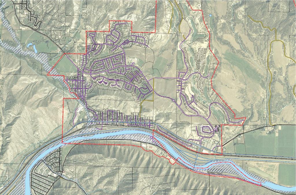
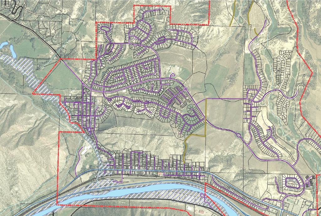
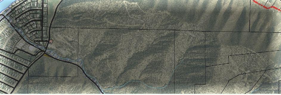
1 LSC TRANSPORTATION CONSULTANTS, INC. 516 North Tejon Street Colorado Springs, CO (719) FAX (719) May 15, 2009 Mr. Davis Farrar Western Slope Consulting, LLC 0165 Basalt Mountain Drive Carbondale, Colorado Dear Mr. Farrar: RE: New Castle Comprehensive Plan Technical Memorandum LSC # In response to your request, LSC Transportation Consultants, Inc. has prepared this technical memorandum discussing the transportation element of the New Castle, Colorado Comprehensive Plan. MEMORANDUM CONTENTS The memorandum identifies major existing transportation limitations in the planning area. It also discusses areas the town could focus on in the future to assure a good transportation system, including improved traffic control, improved traffic circulation, improved or new roadway corridors, interchange improvements, additional interchange consideration, and accommodating transit, bicycles, pedestrians, etc. Details and specifics such as traffic counts and capacity analysis were not included in the scope of work. EXISTING TRANSPORTATION LIMITATIONS These areas are shown graphically in Figure 1. Interstate 70 Exit 105 The existing land use in the Town of New Castle is primarily residential with a large number of residents leaving the town limits each weekday for employment. This results in relatively heavy morning and afternoon peak-hour traffic volumes at the exit 105 interchange on Interstate 70 (I-70). The interchange ramps are controlled with stop-signs. The existing queuing/stacking and vehicle delay are expected to grow along with the community. This will likely result in a continued degradation of the interchange traffic operations. During the existing afternoon peak hour, the westbound offramp stop-sign control frequently results in significant backup/queues on the exit ramp.
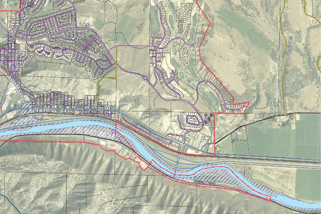
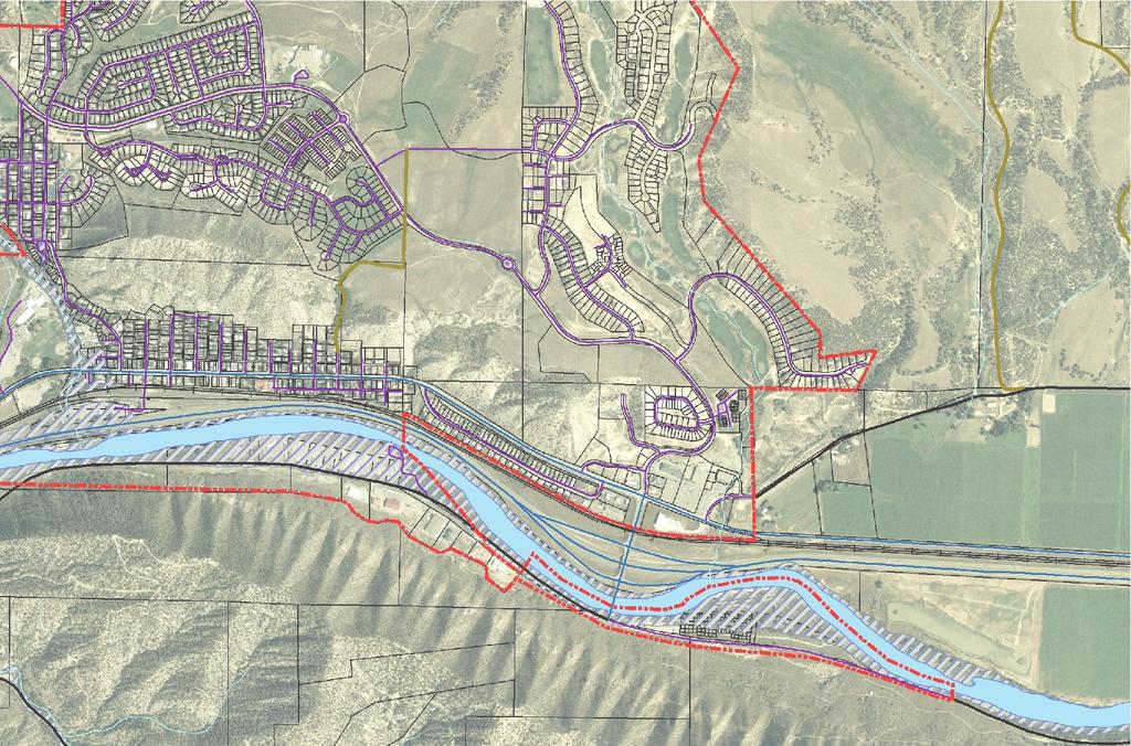
2 Mr. Davis Farrar Page 2 May 15, 2009 New Castle Comprehensive Plan Technical Memorandum Intersection of US Highway 6/Bruce Road/Castle Valley Boulevard The existing intersection is controlled with all-way stop signs and has relatively short auxiliary lanes for many of the turning movements. This intersection acts as a bottleneck for traffic entering/leaving New Castle as it is the only local access to and from the exit 105 interchange on I-70. Queuing/ stacking from the all-way stop signs results in occasional blockage of nearby driveways and intersections. The frequency of this blockage will increase as the community continues to grow. The September 2007 Castle Valley Ranch Traffic Impact Analysis by LSC estimated that the northbound approach of this intersection was operating at level of service (LOS) E with an average delay per vehicle of about 45 seconds during the afternoon peak hour in With continued growth in New Castle, it is assumed that this movement has or will soon degrade to LOS F. The transition from LOS E to F is an average delay per vehicle of 50 seconds. 7 th Street/North Midland Avenue Corridor There are two existing street connections between the north and south sides of New Castle. They are the 7 th Street/North Midland Avenue corridor on the west side of town and Castle Valley Boulevard on the east side of town. The western corridor is a narrow, curvy, two-lane roadway with little opportunity for widening without significant land use impacts. US Highway 6 (Main Street) Downtown Corridor The existing configuration of Main Street through the downtown area is two through lanes in each direction with few auxiliary turn lanes. CDOT data suggests the average daily traffic in this urban area was as high as 7,300 vehicles in The inside or center through lane in each direction is frequently blocked by vehicles waiting to turn left from Main Street. This causes unnecessary delay and increases the likelihood of rear-end collisions. RECOMMENDED FUTURE TRANSPORTATION OBJECTIVES Access to Interstate 70 Future improvements to the existing exit 105 interchange will likely be needed as New Castle continues to grow. Improvements could include auxiliary turn lanes and traffic signal or roundabout control at the on/off ramp intersections with Bruce Road (CR 240) and widening of Bruce Road to include auxiliary turn lanes. This might require widening the Bruce Road bridges over I-70 and over the Colorado River. The addition of single-lane roundabouts at the on- and off-ramp intersections of I-70 with Bruce Road would likely extend the life of the existing bridge because turn lanes would not be necessary approaching the roundabouts as shown in Figure 2. Coordination should be maintained with the Colorado Department of Transportation (CDOT) in these efforts.
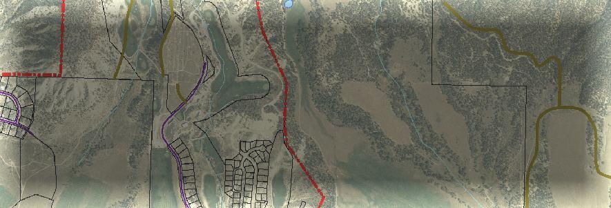
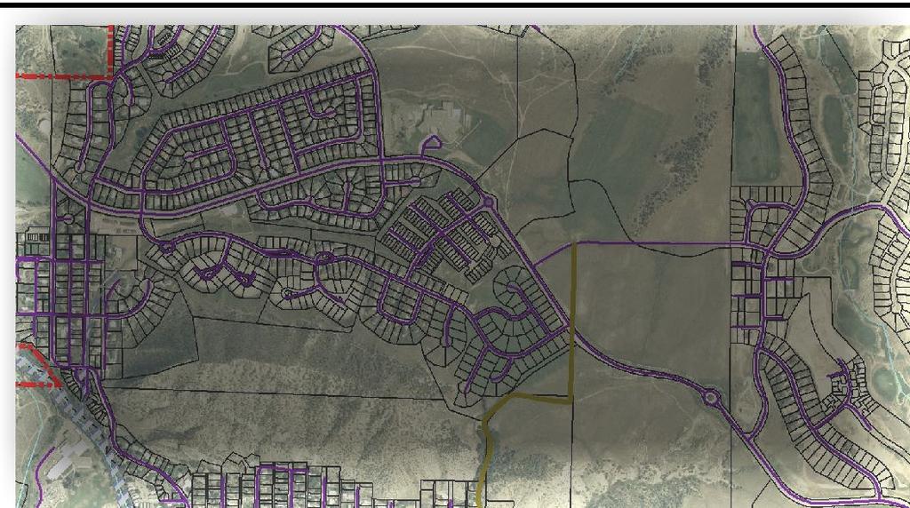
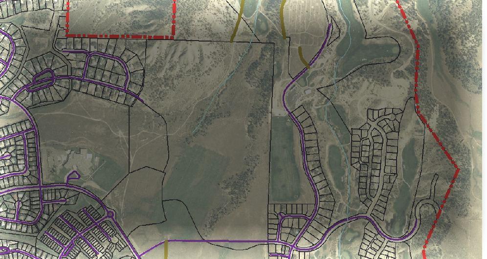
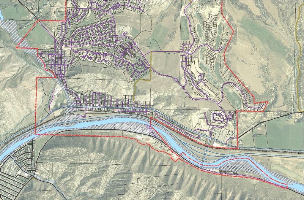
3 Mr. Davis Farrar Page 3 May 15, 2009 New Castle Comprehensive Plan Technical Memorandum It is likely the need for future interchanges will be driven by future land use decisions. Coordination efforts with CDOT should include long-range planning discussions of possible interchange locations east and west of exit 105 in the event additional access becomes desirable. Intersection of US Highway/Bruce Road/Castle Valley Boulevard The September 2007 report recommended future signalization or two-lane roundabout control to provide acceptable operations. Also recommended was the widening of Castle Valley Boulevard to four lanes from I-70 to Blackhawk Drive. It was stated in the TIA that these recommended improvements are largely to mitigate overall growth in the New Castle area and not from one specific development or area. These recommendations are shown graphically in Figure 2. 7 th Street/North Midland Avenue Corridor As New Castle and the unincorporated portion of Garfield County along Buford Road (County Road 245) continue to grow, it will be important to identify acceptable long-term options for north/south travel alternatives on the west side of town. This will be a challenging task due to the existing land uses and topography in the area. Figure 3 shows two alternative long-term alignments that could be considered. It is likely the west connection to US Highway (US) 6 will require either traffic signal or roundabout control in the future. A significant amount of future traffic impact along the west side of New Castle could result from growth to the north in unincorporated Garfield County. The Town of New Castle should coordinate with Garfield County to ensure that any significant development in Garfield County acceptably documents the traffic impacts and makes recommendations for mitigation. This could involve helping to develop an alignment similar to those shown on Figure 3. US Highway 6 (Main Street) Downtown Corridor It would be appropriate to consider converting the existing four-lane cross section to a more urbanfriendly section. It may be appropriate to provide a three-lane cross section with adjacent parking and/or bike lanes. The three-lane section would include one through lane in each direction and a center, two-way, left-turn lane (TWLTL). This should improve safety considering the number of driveways/public intersections in the area. Where appropriate, the TWLTL could be striped as an unloading area for trucks serving area businesses. This may be appropriate if enough businesses in the area cannot accommodate large vehicles on site. East/West Connectivity It is important as the Town of New Castle expands to the east that an east/west Collector roadway connection be provided between the Lakota Golf Course area and Bruce Road (CR 240) and possibly US 6. This was shown conceptually in the town s three-mile plan. Recent development has resulted
4 Mr. Davis Farrar Page 4 May 15, 2009 New Castle Comprehensive Plan Technical Memorandum in a need to revisit the original connections of the three-mile plan. A conceptual layout is shown graphically in Figure 4. Expanded Transit Service Currently, the Roaring Fork Transit Authority (RFTA) provides bus service to New Castle at I-70 but provides no local service to area residents. It may be appropriate to consider a local circulator route to serve local land uses and connect with existing RFTA service. This concept is shown in Figure 5. Impact Fee Consideration It would be appropriate to consider developing an impact fee program to help fund many of the future transportation improvements suggested above. There are several ways impact fees could be handled. A few examples include: Assessment on all existing and future properties Fee based on average daily one-way trip ends generated by a proposed development Fee based on peak-hour one-way trips ends generated by a proposed development Fee based on density of development, such as per dwelling unit or per 1,000 square feet of commercial space. Some communities have chosen to use this method and waive the first 500 or 1,000 square feet of commercial space as a break to small businesses. The consideration of a transportation fee should be channeled through the public involvement process to clearly define the intent of the proposed fee and to determine what collection method is in the best interest of the community. DISCUSSION OF IMPROVEMENT TIMELINE Prioritizing the recommended roadway improvements is one of the first and most important tasks the Town of New Castle should consider. Short-Term Improvements Based on the above analysis, it appears the most critical roadway improvements will be the westbound ramp at the exit 105 interchange on I-70 and the US 6/Bruce Road/Castle Valley Boulevard intersection. Implementing a single-lane roundabout at the westbound off-ramp at the exit 105 interchange on I-70 could significantly extend the functional life of the existing two-lane bridge at the interchange since no turn lanes would be required. Implementing a two-lane roundabout at the US 6/Bruce Road/Castle Valley Boulevard intersection would eliminate the need for additional turn lanes. It would also allow the nearby driveways more
5 Mr. Davis Farrar Page 5 May 15, 2009 New Castle Comprehensive Plan Technical Memorandum functionality than traffic signal control, once the traffic volumes and stacking/queuing become heavy enough to restrict these driveways to right-in/right-out or three-quarter movements (with no left-turn movements from the driveways). Intermediate-Term Improvements Improving the US 6 corridor would likely encourage residents to patronize downtown businesses by providing a safer cross section for the left-turning vehicles and by improving parking and nonmotorized travel. The future widening of Castle Valley Boulevard to four lanes south of Blackhawk Drive will be driven by overall growth on the north side of the Town of New Castle. Improvements Primarily Driven by Future Development South of I-70 The need for improving the eastbound ramp at the exit 105 interchange on I-70 will likely be driven by growth on the south side of I-70, because traffic from this area would conflict with the heavy traffic flow in/out of the Town of New Castle portion north of I-70. It would be appropriate for proposed developments in this area to be required to show when this roadway improvement may become necessary through a traffic impact analysis (TIA). Long-Term Improvements It is likely the existing north/south connection with US 6 on the west side of the Town of New Castle will require either traffic signal or roundabout control in the future. A significant amount of future traffic impact along the west side of New Castle could result from growth to the north in unincorporated Garfield County. The Town of New Castle should coordinate with Garfield County to ensure that any significant development in Garfield County documents the traffic impacts and makes recommendations for mitigation. This could involve helping to develop a long-term alignment similar to those shown on Figure 3. It is likely the need for future I-70 interchanges will be driven by future land use decisions. Coordination efforts with CDOT should include long-range planning discussions of possible interchange locations east and west of exit 105 in the event additional access becomes desirable. SUMMARY There are limiting transportation conditions in the Town of New Castle area which, over time, will degrade intersection operations, increase vehicle delay, and reduce overall safety. It is recommended that issues be addressed by establishing clear transportation objectives as identified in this analysis. * * * * *
6
7
8
9
10
11
Appendix C. NORTH METRO STATION AREA TRAFFIC IMPACT STATEMENT 88th Avenue Station
 Appendix C NORTH METRO STATION AREA TRAFFIC IMPACT STATEMENT 88th Avenue Station Prepared for: Regional Transportation Department and URS Corporation as part of the North Metro EIS David Evans and Associates,
Los Altos Hills Town Council - June 18, 2015 Palo Alto City Council June 22, AGENDA ITEM #2.B Presentation
 Los Altos Hills Town Council - June 18, 2015 Palo Alto City Council June 22, 2015 AGENDA ITEM #2.B Presentation Previous Presentations Los Altos Hills Town Council in May 2014 and February 2015 Palo Alto
WISCONSIN AVENUE EXTENSION SECOND PUBLIC INFORMATION MEETING. March 28, 2017
 WISCONSIN AVENUE EXTENSION SECOND PUBLIC INFORMATION MEETING March 28, 2017 STUDY AREA N MEETING AGENDA Introductions Study Background Alternatives Studied Recommended Alternative Discussion STUDY BACKGROUND
Classification Criteria
 SCHEDULE D TO RECOMMENDED OFFICIAL PLAN AMENDMENT NO. 40 SCHEDULE C-4 Road Criteria Criteria Traffic Service Objective Land Service/Access Typical Daily Traffic Volume Flow characteristics Travel Speed
4. ENVIRONMENTAL IMPACT ANALYSIS 9. TRANSPORTATION AND TRAFFIC
 4. ENVIRONMENTAL IMPACT ANALYSIS 9. TRANSPORTATION AND TRAFFIC 4.9.1 INTRODUCTION The following section addresses the Proposed Project s impact on transportation and traffic based on the Traffic Study
Angie Silva Kitsap County Commissioners Office Stef Herzstein, PE, PTOE Transpo Group Jessica Lambert Transpo Group
 DRAFT MEMORANDUM Date: September 30, 2016 TG: 16125.00 To: From: cc: Subject: Angie Silva Kitsap County Commissioners Office Stef Herzstein, PE, PTOE Transpo Group Jessica Lambert Transpo Group Erik Rundell
Include autoturn exhibits of WB-67 trucks at each roundabout.
 1 Along the through path, the desired relationship is R1>R2
Summary: Mercer County Princeton Avenue & Spruce Street Study January 2009
 Summary: Several recent studies have assessed potential development and redevelopment opportunities in the Mercer Crossing area of Trenton, Ewing, and Lawrence. This Princeton Avenue and Spruce Street
1 st and 2 nd Street Couplet FAQ s
 1 st and 2 nd Street Couplet FAQ s Q. Will the proposed roundabout at Flume/2nd/1 st Streets affect access to businesses nearby?... 2 Q. What if the project isn t received well by the community after construction?...
PRELIMINARY DRAFT WADDLE ROAD / I-99 INTERCHANGE PROJECT ALTERNATIVE ANALYSIS FINAL TRAFFIC SUMMARY REPORT
 PRELIMINARY DRAFT WADDLE ROAD / I-99 INTERCHANGE PROJECT ALTERNATIVE ANALYSIS FINAL TRAFFIC SUMMARY REPORT Prepared by: In Association with: November 2013 EXECUTIVE SUMMARY Patton Township, in partnership
King Soopers #116 Thornton, Colorado
 Traffic Impact Study King Soopers #116 Thornton, Colorado Prepared for: Galloway & Company, Inc. 1.0 EXECUTIVE SUMMARY King Soopers #116, a grocery marketplace anchored commercial development, is proposed
Foothill Expressway Improvements Between El Monte and San Antonio
 Foothill Expressway Improvements Between El Monte and San Antonio June 29, 2017 - Los Altos Community Meeting Introduction Project Background Agenda Visit Stations: Provide Input and Ask Questions Reconvene:
TRAFFIC ASSESSMENT River Edge Colorado
 TRAFFIC ASSESSMENT River Edge Colorado Submitted by: Fehr & Peers 621 17th Street, Ste. 231 Denver, CO 8293 (33) 296-43 December, 21 App. M-2 Traffic Assessment River Edge Colorado December 21 TABLE OF
Glenn Avenue Corridor Traffic Operational Evaluation
 Glenn Avenue Corridor Traffic Operational Evaluation PREPARED FOR: THE CITY OF AUBURN PREPARED BY: DECEMBER 2007 Glenn Avenue Corridor Study--Auburn, Alabama TABLE OF CONTENTS Introduction... 1 Background
Lyons Avenue/Dockweiler Road Extension Project Draft Environmental Impact Report. Appendix I Traffic Impact Study
 Lyons Avenue/Dockweiler Road Extension Project Draft Environmental Impact Report Appendix I Traffic Impact Study Street 0 80-1947 500.4501 RITA ld Court 0 91355-1096 400.7401 LA n Avenue 0 590-3745 300-9301
TRAFFIC ACTION PLAN. Laurie Meadows Neighborhood CITY OF SAN MATEO
 TRAFFIC ACTION PLAN Laurie Meadows Neighborhood CITY OF SAN MATEO Draft January 2017 Table of Contents Introduction... 2 The Traffic Forum Process... 5 Neighborhood Traffic Issues... 7 Neighborhood Recommendations
Appendix B. Environmental Resource Technical Memorandum. Assessment on Travel Pattern and Access Impacts
 Appendix B Environmental Resource Technical Memorandum Assessment on Travel Pattern and Access Impacts TECHNICAL MEMORANDUM ENVIRONMENTAL RE-EVALUATION FOR UNION STATION TO OAK CLIFF DALLAS STREETCAR To:
APPENDIX G: INTERSECTION NEEDS AT OKEECHOBEE BOULEVARD
 APPENDIX G: INTERSECTION NEEDS AT OKEECHOBEE BOULEVARD INTERSECTION NEEDS AT SR 7 and OKEECHOBEE BOULEVARD SR 7 Extension Project Development and Environment (PD&E) Study From Okeechobee Boulevard (SR
Giles Run Connector Road
 Giles Run Connector Road Laurel Hill Adaptive Reuse Area to Laurel Crest Drive South County Federation Meeting June 14, 2016 History Connector road included in the Laurel Hill Comprehensive Plan amendment
3.0 PROJECT DESCRIPTION
 The following section of the Draft EIR contains a description of the proposed Elk Grove Boulevard/SR 99 Interchange Modification project, consistent with the requirements of CEQA Guidelines Section 15124.
University Hill Transportation Study Technical Memorandum Alternatives Modeling and Analysis May 2007
 Technical Memorandum May 2007 Syracuse Metropolitan Transportation Council Edwards and Kelcey with Wallace Roberts and Todd Alta Planning and Design CONTENTS SECTION ONE- INTRODUCTION...1 SECTION TWO-
Technical. BACKGROUND corridor from. The Castle Rock. To: RE: SH 86-Founders. results and. as high volumes. This. no formal. intersection.
 Technical Memorandum To: The Castle Rock Town Council and Public Works Commission From: CDOT Region 1 Traffic Operations Unit RE: SH 86-Founders Pkwy/Allen Way Intersection Assessment of Alternatives INTRODUCTION
Shockoe Bottom Preliminary Traffic and Parking Analysis
 Shockoe Bottom Preliminary Traffic and Parking Analysis Richmond, Virginia August 14, 2013 Prepared For City of Richmond Department of Public Works Prepared By 1001 Boulders Pkwy Suite 300, Richmond, VA
TRAFFIC IMPACT STUDY CRITERIA
 Chapter 6 - TRAFFIC IMPACT STUDY CRITERIA 6.1 GENERAL PROVISIONS 6.1.1. Purpose: The purpose of this document is to outline a standard format for preparing a traffic impact study in the City of Steamboat
Traffic Impact Analysis Walton Acres at Riverwood Athletic Club Clayton, NC
 Traffic Impact Analysis Walton Acres at Riverwood Athletic Club Clayton, NC 1. TABLE OF CONTENTS INTRODUCTION...1 1.1. Site Location and Study Area...1 1.2. Proposed Land Use and Site Access...2 1.3.
TRANSPORTATION ANALYSIS REPORT US Route 6 Huron, Erie County, Ohio
 TRANSPORTATION ANALYSIS REPORT US Route 6 Huron, Erie County, Ohio December 12, 2012 Prepared for: The City of Huron 417 Main Huron, OH 44839 Providing Practical Experience Technical Excellence and Client
MOUNTAIN HOUSE SPECIFIC PLAN I 9.1 INTRODUCTION ASSUMPTIONS TRANSPORTATION FACILITIES TRANSPORTATION IMPROVEMENTS PHASING 9.
 CHAPTER NINE: TRANSPORTATION AND CIRCULATION 9.1 INTRODUCTION 9.1 9.2 ASSUMPTIONS 9.1 9.3 TRANSPORTATION FACILITIES 9.1 9.4 TRANSPORTATION IMPROVEMENTS PHASING 9.3 LIST OF FIGURES LIST OF TABLES Figure
TRAFFIC IMPACT ANALYSIS
 TRAFFIC IMPACT ANALYSIS FOR THE CHAMPAIGN UNIT#4 SCHOOL DISTRICT PROPOSED HIGH SCHOOL (SPALDING PARK SITE) IN THE CITY OF CHAMPAIGN Final Report Champaign Urbana Urbanized Area Transportation Study 6/24/2014
Appendix D: Concept Screening
 Concept Description Concept #1 Route 288 Roadway Widening This concept consists of constructing a third lane on northbound and southbound Route 288 between Powhite Parkway and US 360. This improvement
CITY OF OTTAWA ROADWAY MODIFICATION APPROVAL UNDER DELEGATED AUTHORITY
 RMA-2015-ATM-038 CITY OF OTTAWA ROADWAY MODIFICATION APPROVAL UNDER DELEGATED AUTHORITY DATE: April 22, 2015 SUBJECT Approval of Roadway Modifications Recommended through an Area Traffic Management Study
M-58 HIGHWAY ACCESS MANAGEMENT STUDY Mullen Road to Bel-Ray Boulevard. Prepared for CITY OF BELTON. May 2016
 M-58 HIGHWAY ACCESS MANAGEMENT STUDY Prepared for CITY OF BELTON By May 2016 Introduction Missouri State Highway 58 (M-58 Highway) is a major commercial corridor in the City of Belton. As development has
Mission Bay Loop (MBL) Public Meeting
 Public Meeting") Mission Bay Loop (MBL) Public Meeting La Scuola Internazionale di San Francisco, November 18, 2014 Frequently Asked Questions 1. When would construction have to start before the SFMTA loses TIGER funds?
Mission Bay Loop (MBL) Public Meeting La Scuola Internazionale di San Francisco, November 18, 2014 Frequently Asked Questions 1. When would construction have to start before the SFMTA loses TIGER funds?
Reference number /VP. Lafayette Downtown Congestion Study - Additional Traffic Analysis
 To James Hinkamp and Tony Coe, City of Lafayette Date January 19, 2017 Copies Reference number 243381/VP From Michael Iswalt and Vanessa Peers File reference 4-05 Subject Lafayette Downtown Congestion
Access Management Regulations and Standards
 Access Management Regulations and Standards Efficient highway operation Reasonable property access Concept of Access Management The way to manage access to land development while simultaneously preserving
Boston Post Road Design Feasibility Study
 Boston Post Road Design Feasibility Study Prepared for the City of Rye Final Report July 18, 2007 Prepared by: Buckhurst Fish & Jacquemart (BFJ) 115 Fifth Avenue New York, NY 10003 www.bfjplanning.com
TRAFFIC IMPACT STUDY COMPREHENSIVE UPDATE TOWN OF THOMPSON S STATION, TENNESSEE PREPARED FOR: THE TOWN OF THOMPSON S STATION
 TRAFFIC IMPACT STUDY COMPREHENSIVE UPDATE TOWN OF THOMPSON S STATION, TENNESSEE PREPARED FOR: THE TOWN OF THOMPSON S STATION Transportation Consultants, LLC 1101 17 TH AVENUE SOUTH NASHVILLE, TN 37212
INTRODUCTION THOROUGHFARE SYSTEM CLASSIFICATIONS
 INTRODUCTION The thoroughfare plan will assist public officials in the development of a specialized system for efficient and safe movement of vehicular traffic while minimizing potential conflicts with
CarMax Auto Superstore/ Reconditioning Center #6002 Murrieta, California
 CarMax Auto Superstore/ Reconditioning Center #6002 Murrieta, California TUSTIN 17782 17th Street Suite 200 Tustin, CA 92780-1947 714.665.4500 Fax: 714.665.4501 LOS ANGELES 145 S. Spring Street Suite 120
CITY OF LOS ANGELES INTER-DEPARTMENTAL MEMORANDUM
 CITY OF LOS ANGELES INTER-DEPARTMENTAL MEMORANDUM Date: April 1, 219 To: Honorable City Council c/o City Clerk, Room 395, City Hall Attention: Honorable Mike Bonin, Chair, Transportation Committee From:
Harrah s Station Square Casino
 Transportation Analysis Harrah s Station Square Casino Pittsburgh, Pennsylvania Submitted To: City of Pittsburgh and Pennsylvania Gaming Control Board Prepared By: DKS Associates GAI Consultants December
Overland Traffic Consultants, Inc. October 15, Mr. Bruce McBride Project Delivery Analysts, LLC Shawnee Street Moorpark, CA 93021
 Overland Traffic Consultants 952 Manhattan Beach Boulevard, Suite #100 Manhattan Beach, CA 90266 Phone (661) 799-8423 E-mail: otc@overlandtraffic.com October 15, 2015 Mr. Bruce McBride Project Delivery
Access Management Regulations and Standards
 Access Management Regulations and Standards January 2014 Efficient highway operation Reasonable property access Concept of Access Management The way to manage access to land development while preserving
COMMUNITY MEETING AGENDA
 COMMUNITY MEETING AGENDA Welcome and Introductions SAFE Presentation Project Presentation Priorities Feedback Next Steps Q&A Santa Cruz Avenue Corridor Study 1 Santa Cruz Avenue Corridor Study Community
Meadowlake Ranch Traffic Impact Analysis (LSC #184600) August 27, 2018
 August 27, 2018") LSC TRANSPORTATION CONSULTANTS, INC. 545 East Pikes Peak Avenue, Suite 210 Colorado Springs, CO 80903 (719) 633-2868 FAX (719) 633-5430 E-mail: lsc@lsctrans.com Website: http://www.lsctrans.com Traffic
LSC TRANSPORTATION CONSULTANTS, INC. 545 East Pikes Peak Avenue, Suite 210 Colorado Springs, CO 80903 (719) 633-2868 FAX (719) 633-5430 E-mail: lsc@lsctrans.com Website: http://www.lsctrans.com Traffic
Memorandum. Sunday, July 13, Saturday, July 19, 2014
 Memorandum To: David Lowin, Brooklyn Bridge Park Corporation From: Daniel Schack, AICP, PTP Date: Re: Brooklyn Bridge Park Pier 5/6 Loop Road Traffic Study Project No: 14-01-2407 At the request of Brooklyn
180 Grand Avenue, Suite x117 Dowling Associates, Inc.
 180 Grand Avenue, Suite 250 510.839.1742 x117 Oakland, CA 94612 510.839.0871 fax www.dowlinginc.com mbowman@dowlinginc.com Dowling Associates, Inc. Date: Memorandum To: CC: From: Ms. Leah Greenblat City
FINAL Albertville Business Park AUAR Update Traffic Study
 FINAL Albertville Business Park AUAR Update Traffic Study Prepared for City of Albertville, MN July 20, 2017 SRF No. 10060.00 Table of Contents Introduction... 1 Existing Conditions... 1 Data Collection...
Terwillegar Drive Expressway Draft Concept Plan
 Terwillegar Drive Expressway Draft Concept Plan Anthony Henday Drive to Whitemud Drive November 28 5:00-8:00 p.m. December 1 10:00 a.m. - 3:00 p.m. Let s Talk Today you can: Learn about the new direction
SECTION 1 - TRAFFIC PLANNING
 SECTION 1 - TRAFFIC PLANNING 1.1 TRAFFIC OPERATIONS 1.1.1 Roadway Functional Classification The Multnomah County Comprehensive Framework Plan s Policy 34: Trafficways and the Functional Classification
Sixth Line Development - Transit Facilities Plan
 Memorandum Date: November 13, 2012 To: From: c.c. Subject: Rob Freeman (Freeman Planning) Kevin Phillips Sixth Line Development - Transit Facilities Plan 33016631 This memo was prepared to review the transit
Access Location, Spacing, Turn Lanes, and Medians
 Design Manual Chapter 5 - Roadway Design 5L - Access Management 5L-3 Access Location, Spacing, Turn Lanes, and Medians This section addresses access location, spacing, turn lane and median needs, including
Chapter 6 Transportation Plan
 Chapter 6 Transportation Plan Transportation Plan Introduction Chapter 6 Transportation Plan Transportation Plan Introduction This chapter describes the components of Arvada s transportation system, comprised
NORTHSIDE TRANSPORTATION PLAN LIVINGSTON, MONTANA. Prepared for CITY OF LIVINGSTON. Prepared by
 NORTHSIDE TRANSPORTATION PLAN LIVINGSTON, MONTANA Prepared for CITY OF LIVINGSTON Prepared by MARVIN & ASSOCIATES 1 North Transtech Way Billings, MT 591 August 14, 18 P.T.O.E. # 59 NORTHSIDE LIVINGSTON
Highway 111 Corridor Study
 Highway 111 Corridor Study June, 2009 LINCOLN CO. HWY 111 CORRIDOR STUDY Draft Study Tea, South Dakota Prepared for City of Tea Sioux Falls Metropolitan Planning Organization Prepared by HDR Engineering,
Michael A. Werthmann, PE, PTOE Principal
 9575 West Higgins Road, Suite 400 Rosemont, Illinois 60018 p: 847-518-9990 f: 847-518-9987 MEMORANDUM TO: FROM: Brian Lorenc GHB-630, LLC Michael A. Werthmann, E, TOE rincipal Luay R. Aboona, E rincipal
INDUSTRIAL BUILDING 1660 COMSTOCK ROAD CITY OF OTTAWA TRANSPORTATION OVERVIEW. Prepared for:
 INDUSTRIAL BUILDING 1660 COMSTOCK ROAD CITY OF OTTAWA TRANSPORTATION OVERVIEW Prepared for: Simluc Contractors Limited 2550 Blackwell Street, Ottawa K1B 5R1 October 18, 2013 113-584 Overview_1.doc D. J.
MEMORANDUM. Our project study area included the following locations:
 MEMORANDUM Date: To: From: Subject: Najib O. Habesch Nick M. Fomenko, PE, PTOE Bushnell Park North Traffic Assessment BETA Project #: 4461 As part of our contract to undertake the design of the Bushnell
TRAFFIC ACTION PLAN. North Central Neighborhood CITY OF SAN MATEO
 TRAFFIC ACTION PLAN North Central Neighborhood CITY OF SAN MATEO Draft February 2017 Table of Contents Introduction... 1 The Traffic Forum Process... 4 Neighborhood Traffic Issues... 6 Neighborhood Recommendations
Date: September 7, Project #: Re: Spaulding Youth Center Northfield, NH Property. Traffic Impact Study
 To: Ms. Susan C. Ryan Spaulding Youth Center 72 Spaulding Road Northfield, NH 03276 Date: September 7, 2017 Project #: 52455.00 From: Robin Bousa Director of Transportation Systems Re: Spaulding Youth
Welcome. If you have any questions or comments on the project, please contact:
 Welcome This drop-in public open house is intended to provide information about the Bay Street bike lanes project. This project proposes a dedicated cycling facility along Bay Street between Aberdeen Avenue
Welcome! San Jose Avenue Open House August 25, 2015
 Welcome! San Jose Avenue Open House August 25, 2015 Vision Zero The City and County of San Francisco adopted Vision Zero San Francisco Vision Zero High Injury Network as a policy in 2014, committing an
OFFICE/RETAIL DEVELOPMENT 1625 BANK STREET OTTAWA, ONTARIO TRANSPORTATION BRIEF. Prepared for: Canada Inc.
 OFFICE/RETAIL DEVELOPMENT 1625 BANK STREET OTTAWA, ONTARIO TRANSPORTATION BRIEF Prepared for: 9402209 Canada Inc. December 15, 2015 115-625 Report_2.doc D. J. Halpenny & Associates Ltd. Consulting Transportation
MEMORANDUM. David Mohlenbrok, Environmental Services Manager
 MEMORANDUM DATE: August 10, 2017 TO: FROM: RE: Planning Commission Members David Mohlenbrok, Environmental Services Manager Blue Memo # 1 for Rocklin Station Project Comments Received on Initial Study/Mitigated
VDOT I-66 Inside the Beltway Eastbound Widening Environmental Assessment. Staff Recommendations
 VDOT I-66 Inside the Beltway Eastbound Widening Environmental Assessment Staff Recommendations Department of Environmental Services Transportation January 28, 2017 Timeline of Transform66 June 2012: I-66
DEPARTMENT OF ENVIRONMENTAL SERVICES. North Harrison Street (Lee Highway to Little Falls Road) Comparative Analysis. Prepared for:
 Comparative Analysis. Prepared for:") DEPARTMENT OF ENVIRONMENTAL SERVICES North Harrison Street (Lee Highway to Little Falls Road) Comparative Analysis Prepared for: Arlington County Department of Environmental Services 2100 Clarendon Boulevard,
DEPARTMENT OF ENVIRONMENTAL SERVICES North Harrison Street (Lee Highway to Little Falls Road) Comparative Analysis Prepared for: Arlington County Department of Environmental Services 2100 Clarendon Boulevard,
3.0 ACCESS CONTROL PLAN - HARMONY ROAD (SH68)
") 3.0 ACCESS CONTROL PLAN - HARMONY ROAD (SH68) 3.1 Existing Conditions Roadway Physical Characteristics Typical Section The existing typical cross-section for SH68 is shown on Figure 3-1 and is comprised
3.0 ACCESS CONTROL PLAN - HARMONY ROAD (SH68) 3.1 Existing Conditions Roadway Physical Characteristics Typical Section The existing typical cross-section for SH68 is shown on Figure 3-1 and is comprised
11,000. P.M. Peak Hour Vehicles/Hour 10,000 9,000 8,000. Year
 CONGESTION RELIEF TASK FORCE The problem today With traffic levels hampering downtown circulation, and long delays in west Salem, policy makers are evaluating potential transportation infrastructure, programs,
HIGHBURY AVENUE/HAMILTON ROAD INTERSECTION IMPROVEMENTS PUBLIC INFORMATION CENTRE 1 MAY 14, 2015
 HIGHBURY AVENUE/HAMILTON ROAD INTERSECTION IMPROVEMENTS Municipal Class Environmental Assessment PUBLIC INFORMATION CENTRE 1 MAY 14, 2015 ACCESSIBILITY Under the Accessibility Standards 2015 for Customer
Transportation Impact Study. Eagle, Colorado. Frost Creek. Revised March 25, November 30, for PREPARED FOR: PREPARED BY:
 Transportation Impact Study for Frost Creek Eagle, Colorado November, 5 Revised March 5, 6 PREPARED FOR: BCP ARR, LLC c/o Meriwether Companies 9 Valmont Road, Suite Boulder, CO 8 Contact: Garrett Simon
3.16 TRANSPORTATION, CIRCULATION, AND PARKING Regulatory Setting Environmental Setting ROADWAY SYSTEM
 3.16 TRANSPORTATION, CIRCULATION, AND PARKING This section assesses the potential for implementation of the Orchard Park Redevelopment component of the 2018 LRDP to result in impacts related to transportation,
Freeway System Considerations
 Session 11 Jack Broz, PE, HR Green May 5-7, 2010 Freeway System Considerations Mainline Transit: Shoulder Operations, BRT, Stations HOV, HOT, UPA Interchanges Exit Ramps Entrance Ramps Bridges Local Crossings
WELCOME Public Information Centre
 WELCOME Public Information Centre Fernforest Drive Brampton Soccer Centre Community Room #2 Tuesday January 19, 2016 6:30 p.m.to 9:00 p.m. Please sign in Neighbourhood Traffic Calming Guide Background
EXHIBIT B-1 PROJECT DESCRIPTION. Phase 1 of the Preferred Alternative
 EXHIBIT B-1 PROJECT DESCRIPTION Phase 1 of the Preferred Alternative The Transform 66 Public-Private Partnership (P3) Project (the Project ) means the Phase 1 of the Preferred Alternative components of
Roundabouts Near At-Grade Railroad Crossings
 Roundabouts Near At-Grade Railroad Crossings May 12, 2008 1,592 Words Alex J. Ariniello LSC Transportation Consultants, Inc., 1889 York Street Denver, CO 80206 Phone: 303-333-1105 FAX: 303-333-1107 email:
5858 N COLLEGE, LLC N College Avenue Traffic Impact Study
 5858 N COLLEGE, LLC nue Traffic Impact Study August 22, 2016 Contents Traffic Impact Study Page Preparer Qualifications... 1 Introduction... 2 Existing Roadway Conditions... 5 Existing Traffic Conditions...
Preliminary Engineering Study
 Preliminary Engineering Study Open House # 2 June 6, 2018 PREPARED FOR: PREPARED BY: Agenda Background and status of preliminary engineering study County Road 26 design summary County Road 63 design summary
Traffic Circulation Study for Neighborhood Southwest of Mockingbird Lane and Airline Road, Highland Park, Texas
 ARIZONA TEXAS NEW MEXICO OKLAHOMA February 13, 2015 Mr. Meran Dadgostar P.E., R.S. Town of Highland Park 4700 Drexel Dr. Highland Park, Texas 75205 Re: Traffic Circulation Study for Neighborhood Southwest
Traffic Impact Study WestBranch Residential Development Davidson, NC March 2016
 Traffic Impact Study WestBranch Residential Development Davidson, NC March 216 TRAFFIC IMPACT STUDY FOR THE WestBranch Residential Development LOCATED IN DAVIDSON, NC Prepared For: Lennar Carolinas, LLC
METHODOLOGY. Signalized Intersection Average Control Delay (sec/veh)
") Chapter 5 Traffic Analysis 5.1 SUMMARY US /West 6 th Street assumes a unique role in the Lawrence Douglas County transportation system. This principal arterial street currently conveys commuter traffic
Chapter 5 Traffic Analysis 5.1 SUMMARY US /West 6 th Street assumes a unique role in the Lawrence Douglas County transportation system. This principal arterial street currently conveys commuter traffic
Traffic Impact Memorandum. May 22, 2018
 BISHOP PROFESSIONAL DEVELOPMENT BUILDING Proposed Land-use Change & Parking Modification 3601 SW 31st Street Topeka, Kansas 66614 CFS Project No. 185077 Traffic Impact Memorandum May 22, 2018 Prepared
BLUE SEA VILLAGE MER BLEUE 2159 MER BLEUE ROAD OTTAWA, ONTARIO TRANSPORTATION IMPACT ASSESSMENT. Prepared for: Ontario Limited.
 BLUE SEA VILLAGE MER BLEUE 2159 MER BLEUE ROAD OTTAWA, ONTARIO TRANSPORTATION IMPACT ASSESSMENT Prepared for: 2534189 Ontario Limited April 6, 2018 117-668 TIA Report_2.doc D. J. Halpenny & Associates
MEETING FACILITY 2901 GIBFORD DRIVE CITY OF OTTAWA TRANSPORTATION BRIEF. Prepared for: Holiday Inn Express 2881 Gibford Drive Ottawa, ON K1V 2L9
 MEETING FACILITY 2901 GIBFORD DRIVE CITY OF OTTAWA TRANSPORTATION BRIEF Prepared for: Holiday Inn Express 2881 Gibford Drive Ottawa, ON K1V 2L9 December 18, 2012 112-566 Brief_1.doc D. J. Halpenny & Associates
Transportation Impact Study for Abington Terrace
 Transportation Impact Study for Abington Terrace Abington Township, Montgomery County, PA Sandy A. Koza, P.E., PTOE PA PE License Number PE059911 Prepared by McMahon Associates, Inc. 425 Commerce Drive,
EL CAMINO REAL BUS RAPID TRANSIT (BRT) PROJECT
 PROJECT") Agenda Item #4.2 EL CAMINO REAL BUS RAPID TRANSIT (BRT) PROJECT VTA BOARD WORKSHOP MAY 1, 2015 ABOUT THIS PRESENTATION CONTEXT Existing conditions and planning for growth WHAT IS THE PROJECT? Project alternatives
Agenda Item #4.2 EL CAMINO REAL BUS RAPID TRANSIT (BRT) PROJECT VTA BOARD WORKSHOP MAY 1, 2015 ABOUT THIS PRESENTATION CONTEXT Existing conditions and planning for growth WHAT IS THE PROJECT? Project alternatives
Focused Traffic Analysis for the 200 Nellen Avenue Project
 March 13, 2017 Mr. Phil Boyle Town of Corte Madera 300 Tamalpais Drive Corte Madera, CA 94976-0159 Focused Traffic Analysis for the 200 Nellen Avenue Project Dear Mr. Boyle; W-Trans has completed a focused
SH-6 Corridor Improvement Study Policy Committee Progress Report M O N D AY, J U N E 1 0, B R A Z O S C E N T E R
 SH-6 Corridor Improvement Study Policy Committee Progress Report M O N D AY, J U N E 1 0, 2 0 1 3 B R A Z O S C E N T E R Project Overview Study Goals and Objectives» Improve traffic flow» Reduce delay»
Improving Cyclist Safety at the Dundas Street West and Sterling Road Intersection
 STAFF REPORT ACTION REQUIRED Improving Cyclist Safety at the Dundas Street West and Sterling Road Intersection Date: August 17, 2012 To: From: Wards: Reference Number: Public Works and Infrastructure Committee
CHAPTER 3 STUDY AREA OPERATIONAL OVERVIEW
 HPTER 3 STUY RE OPERTIONL OVERVIEW This chapter describes the overall traffic operations within the study area under existing and future conditions and focuses on individual intersections not directly
Public Meeting #1 Comment Summary
 Public Meeting #1 Comment Summary This summary includes comments received on comment forms and during conversations between attendees and project team staff at the February 18, 2016 public open house.
2014/2015 BIKE ROUTE PLAN 83 AVENUE PROTECTED BIKE LANE
 About the Project 2014/2015 BIKE ROUTE PLAN The City of Edmonton is planning a major bike route on the south side of Edmonton. This bike route is one part of a plan to provide citizens with transportation
C C C
 C-012-001 Thank you for your support for the creation of new public space and nonmotorized access between downtown and the waterfront through the Overlook Walk, the East-West Connections, and the Promenade.
David DiPierro, John Amberson. Steering Committee Meeting #4 Overview
 IBI GROUP 18401 Von Karman Avenue Suite 110 Irvine CA 92612 USA tel 949 833 5588 fax 949 833 5511 ibigroup.com Memorandum To/Attention Steering Committee Members Date February 17, 2016 From IBI Group Project
2. NORTEL CARLING CAMPUS EXPANSION - PROPOSED MODIFICATIONS TO MOODIE DRIVE (REGIONAL ROAD 59) AND HIGHWAY 417 INTERCHANGE
 AND HIGHWAY 417 INTERCHANGE") 2. NORTEL CARLING CAMPUS EXPANSION - PROPOSED MODIFICATIONS TO MOODIE DRIVE (REGIONAL ROAD 59) AND HIGHWAY 417 INTERCHANGE COMMITTEE RECOMMENDATIONS AS AMENDED That Council approve: 1. The endorsement
2. NORTEL CARLING CAMPUS EXPANSION - PROPOSED MODIFICATIONS TO MOODIE DRIVE (REGIONAL ROAD 59) AND HIGHWAY 417 INTERCHANGE COMMITTEE RECOMMENDATIONS AS AMENDED That Council approve: 1. The endorsement
Co-ordinator Transportation Committee. Director, Mobility Services and Corporate Fleet Services Environment and Transportation Department
 28 REGIONAL MUNICIPALITY OF OTTAWA-CARLETON MUNICIPALITÉ RÉGIONALE D OTTAWA-CARLETON REPORT RAPPORT Our File/N/Réf. Your File/V/Réf. 25 23-97-R016 DATE 15 April 1997 TO/DEST. FROM/EXP. SUBJECT/OBJET Co-ordinator
Town of Bethlehem. Planning Assessment. Bethlehem Town Board
 Town of Bethlehem US 9W Corridor Transportation Planning Assessment Presented e to: Bethlehem Town Board June 2009 Overview Study Background Route 9W Corridor Conditions and Improvements Selkirk Bypass
Princeton Avenue and Spruce Street Transportation and Site Access Enhancements Project
 Princeton Avenue and Spruce Street Transportation and Site Access Enhancements Project Mercer County Planning Division AECOM Transportation (formerly DMJM Harris) January 29, 2009 Agenda Project Status
THIS PAGE LEFT BLANK INTENTIONALLY
 GA SR 25 Spur at Canal Road Transportation Impact Analysis PREPARED FOR GLYNN COUNTY, GEORGIA 1725 Reynolds Street, Suite 300 Brunswick, Georgia 31520 PREPARED BY 217 Arrowhead Boulevard Suite 26 Jonesboro,
MEDICAL/OFFICE BUILDING 1637 BANK STREET OTTAWA, ONTARIO TRANSPORTATION OVERVIEW. Prepared for:
 MEDICAL/OFFICE BUILDING 1637 BANK STREET OTTAWA, ONTARIO TRANSPORTATION OVERVIEW Prepared for: 2434984 Ontario Inc. 13-5510 Canotek Road Ottawa, Ontario K1J 9J5 June 4, 2015 115-613 Report_2.doc D. J.
CHAPTER 4 TRANSPORTATION IMPACT STUDY TABLE OF CONTENTS
 CHAPTER 4 TRANSPORTATION IMPACT STUDY TABLE OF CONTENTS Section Title Page 4.1 Introduction... 4-1 4.1.1 General... 4-1 4.1.2 Applicant Responsibility... 4-1 4.1.3 Capacity and Safety Issues... 4-1 A.
Bluffdale/ UDOT South High-T Intersection Project Type Operations
 Bluffdale/ UDOT 14600 South High-T Intersection Project Type Operations 14600 South and Redwood Road $ 600,000 $ 550,000 This project is to install a new High-T intersection at Redwood Road and 14600 South