NARRATIVE FOR SERENITY HILL OF HALSTED BAY SERENITY HILL OF LAKE MINNETONKA, LLC
|
|
|
- Gillian Bryan
- 5 years ago
- Views:
Transcription

1 NARRATIVE FOR SERENITY HILL OF HALSTED BAY SERENITY HILL OF LAKE MINNETONKA, LLC January 31, 2016
2 Written statements providing information regarding your proposal. Please provide a separate answer for each of the lettered items listed below (answers must be submitted in both hard copy and electronic form--.txt files or MS Word format): a. A listing of contact information including name(s), address(es) and phone number(s) of: the owner of record, authorized agents or representatives, engineer, surveyor, and any other relevant associates; OWNERS: BERG RESIDENTIAL DEV, LLC Contract Scott Berg Lawndale Lane N Dayton, Mn Pin (Minnetrista) (Tract 1) Pin (Minnetrista) (Tract 2) K. D. & L. A. Reinhart Contract Kim D. & Laurie A. Reinhart Halstead Ave Mound, Mn Pin (Minnetrista) (Tract3) Windsted Investment LLC Contract Mike Pint Hillsboro Ave. N New Hope, Mn Pin (Minnetrista) (Tract 4) Pin (Mound) (Tract 5)
3 DEVELOPER: Serenity Hill of Lake Minnetonka Contract Dan Anderson Phone Montgomerie Avenue Deephaven, Mn SURVEYOR: Duffy Engineering & Associates, Inc Contract Barry R. Dorniden L.S. Phone Highway 10 South St. Cloud, MN CIVIL ENGINEERING: Duffy Engineering & Associates, Inc. with Stark Engineering, LLC Contract Wayne Stark P.E. Phone nd Avenue North Sauk Rapids, MN SOIL BORINGS: Independent Testing Technologies, Inc Contract Pat Johnson P.E. Phone st Avenue South Waite Park, MN LANDSCAPE ARCHITECT: Calyx Design Group, LLC Contract Ben Hartberg Phone Berkeley Avenue Suite A St. Paul, MN 55105
4 b. A listing of the following site data: Address, current zoning, parcel size in acres and square feet, property identification number(s) (PID), and current legal description(s); SITE INFORMATION Minnetrista Tract 1 Pin (Minnetrista) o ± 199,344 square feet - ± 4.58 Acres 6750 Halstead Avenue Tract 2 Pin (Minnetrista) o ± 24,067 square feet - ± 0.55 Acres Address Unassigned Tract 3 Pin (Minnetrista) o ± 26,136 square feet ± 0.60 Acres 6710 Halstead Ave Tract 4 Pin (Minnetrista) o ± 199,006 square feet ± 4.57 Acres 6701 County Road 110 W Current Zoning: R-2 Low-medium density single family residence Legal Descriptions found on preliminary plat Mound Tract 5 Pin (Mound) o ± 68,535 square feet ± 1.57 Acres 6639 Bartlett Blvd Current Zoning: R-1 single family residual district Legal Descriptions found on preliminary plat Proposed Zoning: Planned Unit Development (PUD)
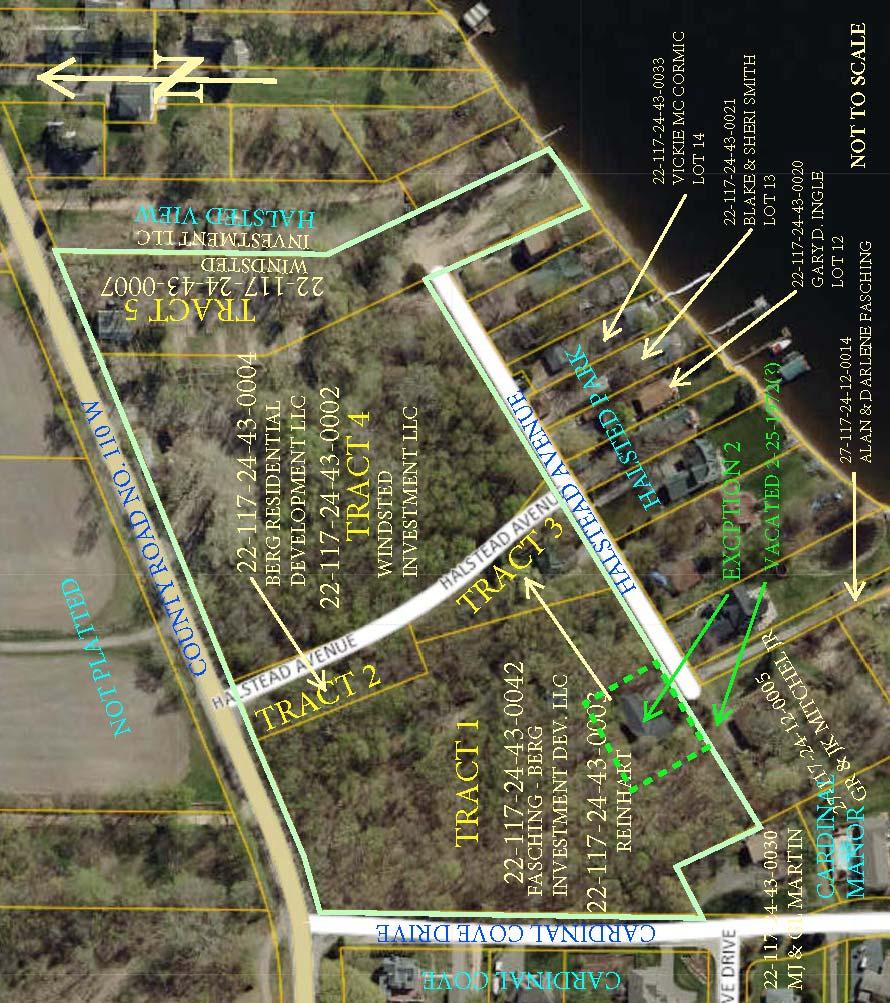
5 AERIAL
6 c. A listing of general information including: the proposed name of the subdivision, the number of proposed lots, acreage dedicated for open space or public use, acreage dedicated within rights of way; Proposed Plat Name: SERENITY HILL ON HALSTED BAY Proposed 4 lot plat Area Summary Lot 1, Block 1, ± 180,198 sq. ft. - ± 4.14 Ac. Minnetrista Lot 1, Block 2, ± 163,767 sq. ft. - ± 3.76 Ac. Minnetrista Lot 2, Block 2, ± 44,916 sq. ft. - ± 1.03 Ac Minnetrista Lot 3, Block 2, ± 17, 967 sq. ft. ± 0.41 Ac. Mound Right of Way, ± 87,228 sq. ft. - ± 2.00 Ac. Total Area ± 494,076 sq. ft. - ±11.34 d. An explanation of how issues have been addressed since the Sketch Plat phase of the development; The following issue that came up at sketch plan and a narration of how they have been addressed 1. Turn lanes from 110 (3) 2. Ponding and or water shed retention 3. Hard cover and the perception of hard cover 4. Setbacks to the West moved to the East substantially 5. Access to the site from the South on Halstead bay removed 6. Fire and Police access 7. Triangle lot purchased 8. Drainage to lake on Lot 12 & 13, HALSTED PARK, located at 6685 and 6689Halstread Avenue 9. Community building at the lake, removed living space 10. Provided a walking path for south, neighbors can walk up and through development to other neighborhoods
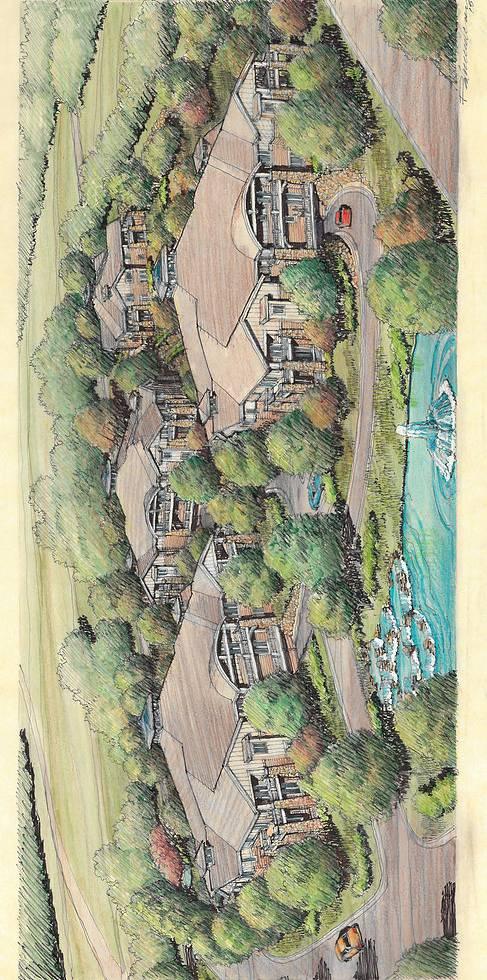
7 e. A narrative explaining the intent of the project and/or your original or revised vision for the finished product; Narrative if the original intent of the project and any change to that intent The intent of the project is to provide a Quiet Community, this is defined as a 60 and older people group, this community is intended to provide a resort type living. The home owners will have access to Lake Minnetonka and a day dock at the lake. There will be on Pontoon boat provided to the development for fishing and sunset cruses. The atmosphere will be that of high amenities that will include, pickle ball, tennis, golfing, shuffle board and pool with tables and changing room. All amenities including the use of the community space at beach will be provided to the neighbors directly to the south that abut Serenity, this allows the entire neighborhood new and existing to again, have a resort type community. A key access card will be provided along with a waiver to each home owner. This will allow them to use all amenities based on the hours of operation provided by the management team at Serenity. As of preliminary submittal, the changes to the overall concept of Serenity and its operation with provided services and amenities, consist of what is listed above d The design of the buildings themselves, provided by Daniel Andersen of Serenity Hill of Lake Minnetonka LLC, also lends itself to blend into the hill, with hidden garage access. The overall exterior having an up north design will allow it also to blend into the tree lines and topography. The most important feature will be that the buildings are that of a POD design, this allows the site layout to have the perception of more green space. Working with the city officials has been a very good experience, and together we have moved, added and changes many items to insure this project will have and be a great benefit to the community.
8
9 f. A statement showing the proposed density of the project with the method of calculating said density shown; Proposed Density: Minnetrista 60 Units - Area within city ± 10.3 Ac. - Proposed Density = 5.8 Units/Ac. Mound 10 Units - Area within city ±1.57 Ac. Proposed Density = 6.4 Units/Ac. Gross Area of Project 70 Units Total Area of Project ±11.34 Ac. s Proposed Density = 6.2 Units/Ac. g. A narrative addressing concerns/issues raised by neighboring properties (staff always suggests discussing your proposal with the neighboring land owners to get a sense of what issues may arise as your application is processed); Address any past concerns of the neighborhood through the provided neighborhood meeting and or any communications from that meeting to present. At the meeting very little was said about hardcover. The fact that Serenity is a PUD design and will allow us to spread out the buildings, provides a far greater amount of green space and tree preservation than typical, with the lay out of the buildings with no typical pattern, along with walk paths, lends its self to more of a park setting. One of the main concerns was walking paths and the ability to get up to 110 and surrounding walking paths that currently exist; we provide a winding path through out Serenity, as well provided space along 110 for a municipal walking path East to West in the future. The community was concerned with having a living space about the community beach house. We have removed this possibility and will only be providing a 2 story (main floor with walk out) building simply for community meetings, and to enjoy a family barbeque with a swimming beach.
10 The design of the buildings themselves, provided by Daniel Andersen of Serenity Hill of Lake Minnetonka LLC, also lends itself to blend into the hill, with hidden garage access. The overall exterior having an up north design will allow it also to blend into the tree lines and topography. The most important feature will be that the buildings are that of a POD design, this allows the site layout to have the perception of more green space. h. Discuss proposed infrastructure extensions (i.e. proposed roadways, sewer systems, water systems, sidewalks/trails, parking, etc); The existing streets within the project: Serenity Place, Halstead Avenue and Cardinal Cove Drive will be upgraded to City standards with concrete curb and gutter as well as bituminous pavement section. The private interior drive aisles will be constructed to a similar standard. Parking requirements will be met utilizing surface parking areas as well as underground parking within the lowest level of each building. Concrete sidewalks will connect the surface parking areas to the building entrances. City sanitary sewer and water main will be extended to serve the proposed buildings and to meet the City s requirements. Storm sewer improvements will consist of a storm sewer system with two stormwater ponds to meet the requirements of the City and Watershed District. A 5-foot wide bituminous surfaced trail will meander through the property to connect the buildings with various amenities. These amenities include a gazebo, shuffleboard, pickle ball court, outdoor pool and pool house, putting green and a community center with lake access. i. A description of how conflicts with nearby land uses (livability, value, potential future development, etc.) and/or disturbances to wetlands or natural areas are being avoided or mitigated; Historically, the site appears to have been mined in the past, most likely for sand and gravel. The site has extensive amounts of fill,
11 especially on the lower portions of the site east of Halstead Avenue and the northeast area of the site west of Halstead Avenue. Also, an area of surface water was observed at the base of the slope west of the existing house at 6639 CR110. This likely some sort of leaking water line or buried utility. It does not seem likely that it is a natural spring. Currently the way the drainage works at this time is simple ground absorption, with the farm fields North and across County Road 110 the drainage is unmanaged. With Serenity, we have engineered two holding ponds to create a stop point for large scale water flow as well as maintenance water flow. This will also improve the drainage across Halsted Ave at the South side of Serenity for water flow to Lake Minnetonka. Aerial photographs from the Minnesota Historical Aerial Photographs website indicate that in 1945, the site appears to be open, level agricultural field. The aerial photograph of the area in 1960 shows the escarpment bisection the site, as well as slope washouts on that slope and on the south of the property adjacent to Halstead Avenue. A large amount of fill was encounter in many of the soil borings. The fill was likely due to previous mining activities as well as the previous develop of a mobile home park. The upper portion of the site to the east includes old pavement and abandoned utilities from an abandoned trailer court, which will be removed appropriately during construction. j. Provide justification that the proposal will not place an excessive burden on roads (traffic), sewage, water supply, parks, schools, fire, police, or other public facilities/services (including traffic flows) in the area. The proposed project consists of 60 units for the Minnetrista parcel and 10 units for the Mound parcel. This equates to 5.8 units per acre and 6.4 units per acre, respectively for each parcel. This proposed density is similar to other projects of this size and the proposed design is intended to not place excessive burden on the existing City infrastructure (utilities or roads).
12 The proposed improvements to County Road 110 will improve the existing traffic conditions at its intersections with Serenity Drive and Cardinal Cove Road. Since this is a senior living development with the previously described amenities, minimal burden is placed on City parks or schools. Since the City Fire and Police departments already serve this area, no excessive burden is expected and the proposed improvements should improve access and services to the surrounding properties. k. If applicable, provide a description of proposed lakeshore access (i.e. shared dock with multiple slips, individual docks for each lot, etc.); Provide lakeshore and dock usage Day dock only with one community pontoon bout for day cruises. l. A description of proposed parks and/or open space. Please include a brief statement on the proposed ownership and maintenance of said areas; With the proposed improvements, the disturbed area associated with this project is minimized, especially on the west side of the parcel. While no parks are proposed with this development, the community uses (shuffleboard, pickle ball court, gazebo, pool, etc) and proposed open spaces will be owned and maintained by the condo association. The open space shown on the site plan will have a park / resort feel to it. The protection of existing foliage and tree preservation is very important the brand recognition. The path will be hard scaped with occasional low path lighting and benches. The path will wind through Serenity with stops at the different amenities listed above. It is serenities objective to have the home owners with in Serenity and the homes adjacent to Serenity, have a resort experience is using this path and open spaces. The design of the buildings themselves, provided by Daniel Andersen of Serenity Hill of Lake Minnetonka LLC, also lends itself to blend into the hill, with hidden garage access. The
13 overall exterior having an up north design will allow it also to blend into the tree lines and topography. The most important feature will be that the buildings are that of a POD design, this allows the site layout to have the perception of more green space. m. A proposed development schedule indicating the approximate date when construction of the project, or stages of the same, can be expected to begin and be completed (including the proposed phasing of construction of public improvements and recreational and common space areas). Project schedule It is the hope that Serenity will begin infrastructure construction late spring, early summer of The actual building construction will consist of only 2 buildings at any one time, and construction to begin July / August It is very important that we do NOT stress out the existing neighborhood and build all at one time. Serenity will provide construction entrances off the main road and keep all construction traffic to a minimum. It is our hope that this project will be complete mid Draft: Rev:
14 PROPOSED BUILDING SETBACKS: BLOCK 1, LOT 1, County Road No. 110 Cardinal Cove Halstead Avenue South Property Line BLOCK 2, LOT 1 County Road No. 110 Halstead Avenue East Line - 30 Feet - 10 Feet - 10 Feet (East Side & South Side) - 10 Feet - 30 Feet - 10 Feet (West Side & South Side) - 10 Feet BLOCK 2, LOT 2 County Road No Feet West Line - 8 Feet East Line - 10 Feet Halstead Avenue - 4 Feet (South Side Bump out) BLOCK 2, LOT 3 West Line East Line Halstead Avenue Lake Side - 8 Feet - 10 Feet - 4 Feet (South Side Bump out) Feet From OHW
15 LOT AREAS: DESCRIPTION SQUARE ACRES BUILDABLE FOOTAGE AREA W/OUT SETBACK Block 1 Lot 1 +/- 180,198 S.F. +/ Ac. +/- 154,404 S.F. Block 2 Lot 1 +/- 163,767 S.F. +/ Ac. +/- 139,130 S.F. Block 2 Lot 2 +/- 44,916 S.F +/ Ac. +/- 33,434 S.F. Block 2 Lot 3 +/- 17,997 S.F +/ Ac. +/- 6,760 S.F. Public Road +/- 87,228 S.F +/ Ac. Total +/- 494,106 S.F +/ Ac. Exception +/- 23,000 S.F. +/ Ac. R.O.W. County Road No /- 42,184 S.F. +/ Ac. Cardinal Cove +/- 5,102 S.F. +/ Ac. Halstead Avenue +/- 39,942 S.F. +/ Ac. Total R.O.W. +/- 87,228 S.F. +/ Ac.
16 LOT COVERAGE SUMMARY A. IMPERVIOUS SURFACE AREAS BLOCK 1 LOT 1 +/- 180,198 S.F. Buildings +/- 36,580 S.F. Pavement +/- 12,907 S.F. Total +/- 49,487 S.F. Percentage Of Hard Cover 27.5 % BLOCK 2 LOT 1 +/- 163,767 S.F. Buildings +/- 55,317 S.F. Pavement +/- 5,331 S.F. Total +/- 60,648 S.F. Percentage Of Hard Cover 37.0% BLOCK 2 LOT 2 +/- 44,916 S.F Buildings +/- 15,480 S.F. Pavement +/- 0 S.F. Total +/- 15,480 S.F. Percentage Of Hard Cover 34.5 % BLOCK 2 LOT 3 +/- 17,997 S.F Buildings +/- 2,460 S.F. Pavement +/- 0 S.F. Total +/- 2,460 S. F. Percentage Of Hard Cover 13.7% RIGHT OF WAY +/- 87,228 S.F. Buildings +/- N/A S.F. Pavement +/- 39,625 S.F. Total +/- 39,625 S.F.. Percentage Of Hard Cover 45.4%
17 B. PERVIOUS SURFACE AREAS BLOCK 1 LOT 1 +/- 180,198 S.F. Pavers +/- 7,036 S.F. Sidewalk +/- 2,164 S.F. Trail +/- 3,012 S.F. Grass +/- 118,499 S.F. Total +/- 130,711 S.F. BLOCK 2 LOT 1 +/- 163,767 S.F. Pavers +/- 12,794 S.F. Sidewalk +/- 2,748 S.F. Trail +/- 6,446 S.F. Grass +/- 81,131 S.F. Total +/- 103,119 S.F. BLOCK 2 LOT 2 +/- 44,916 S.F Pavers +/- 2,249 S.F. Sidewalk +/- 1,313 S.F. Trail +/- 1,584 S.F. Grass +/- 24,290 S.F. Total +/- 29,436 S.F. BLOCK 2 LOT 3 +/- 17,997 S.F Pavers +/- 0 S.F. Sidewalk +/- 361 S.F. Trail +/- 0 S.F. Grass +/- 15,176 S.F. Total +/- 15,537 S.F. RIGHT OF WAY +/- 87,228 S.F. Pavers +/- N/A S.F. Sidewalk +/- N/A S.F. Trail +/- 1,536 S.F. Grass +/- 46,067 S.F. Total +/- 47,603 S.F.
SIDEWALK GUIDELINES April 14, 2008
 SIDEWALK GUIDELINES April 14, 2008 I. Introduction The issue of sidewalks represents a delicate balance that must be considered carefully. On the one hand, in certain circumstances, sidewalks are needed
Planning & Zoning Commission
 Preliminary Plat Westwood, Section 3 Planning & Zoning Commission Planning & Development Department March 21, 2016 Request Subdivide approximately 38.1 acres of previously unplatted property to create
Town of Kiawah Island Board of Zoning Appeals
 Town of Kiawah Island Board of Zoning Appeals March 19, 2018 Town of Kiawah Island Municipal Center 4475 Betsy Kerrison Parkway Kiawah Island, SC 29455 CASE# BZA-12-17-00233 Applicant/Property Owner(s):
WHEREAS delivery trucks also pass through the Narrows, into the northern parking lot, to loading docks in the back of the building.
 CEDAR-ISLES-DEAN NEIGHBORHOOD ASSOCIATION ( CIDNA ) RESOLUTION OPPOSING A DRUG STORE DRIVE THRU, AND COMMENDING DORAN COMPANIES FOR PROPOSING MITIGATING AMENITIES INCLUDING NEW LANDSCAPING AND A DEDICATED
Roadway Classification Design Standards and Policies. Pueblo, Colorado November, 2004
 Roadway Classification Design Standards and Policies Pueblo, Colorado November, 2004 Table of Contents Page Chapter 1. General Provisions 1.1 Jurisdiction 3 1.2 Purpose and Intent 3 1.3 Modification 3
Midway City Council 15 January 2019 Regular Meeting. Homestead Villas / Preliminary Approval
 Midway City Council 15 January 2019 Regular Meeting Homestead Villas / Preliminary Approval CITY COUNCIL MEETING STAFF REPORT DATE OF MEETING: January 15, 2018 NAME OF PROJECT: NAME OF APPLICANT: AGENDA
This Chapter sets forth the minimum design, technical criteria and specifications to be used in the preparation of all roadway plans.
 4.1 GENERAL This Chapter sets forth the minimum design, technical criteria and specifications to be used in the preparation of all roadway plans. These Roadway Standards are for new construction and modification
T A B L E OF C O N T E N T S
 T A B L E OF C O N T E N T S PART III SUBDIVISION REGULATIONS OF THE DEPARTMENT OF PUBLIC WORKS, C & C D PAGE PAGE Responsibility for Development of Streets......... 29 Right-of-Way Widths...... 37 Purpose...........
Building Great Neighbourhoods BELLEVUE AND VIRGINIA PARK
 Building Great Neighbourhoods BELLEVUE AND VIRGINIA PARK This is Meeting 2 Unfortunately, some residents in Bellevue and Virginia Park received the wrong information for this public open house (Meeting
West Dimond Blvd Upgrade Jodhpur Street to Sand Lake Road
 West Dimond Blvd Jodhpur St to Sand Lake CSS Transportation Project Summary Municipality of Anchorage Project # 05 005 Project Manager: John Smith, P.E. (MOA PM&E) Project Administrator: Julie Makela,
Access requests to County streets and roadways are processed through one of the following methods:
 13.1 GENERAL APPLICATION PROCESS Access requests to County streets and roadways are processed through one of the following methods: A. Planned Developments may set general locations for access points.
TRAFFIC IMPACT STUDY CRITERIA
 Chapter 6 - TRAFFIC IMPACT STUDY CRITERIA 6.1 GENERAL PROVISIONS 6.1.1. Purpose: The purpose of this document is to outline a standard format for preparing a traffic impact study in the City of Steamboat
Item to be Addressed Checklist Consideration YES NO N/A Required Description Complete Streets Guidelines
 Passaic County Complete Streets Checklist - Concept Development Project Name Item to be Addressed Checklist Consideration YES NO N/A Required Description Complete Streets Guidelines Existing Plans Have
5 CIRCULATION AND STREET DESIGN
 5 CIRCULATION AND STREET DESIGN This chapter describes circulation and streetscape improvements proposed for the Northwest Chico Specific Plan Area. It includes detailed design specifications for existing
STAFF REPORT TO THE PLANNING COMMISSION December 12,2016. Schuler Shoes PUD Concept and Development Stage Plan And Rezoning
 STAFF REPORT TO THE PLANNING COMMISSION December 12,2016 PUD Concept and Development Stage Plan And Rezoning Applicant: Owner: Requested Action: Location: Zoning: Edward Farr Architects Brad Neuerburg
Building Great Neighbourhoods QUEEN ALEXANDRA
 Building Great Neighbourhoods QUEEN ALEXANDRA We are here today to Explain how the City is investing in improving your neighbourhood and how your neighbourhood will be improved to meet current City standards.
Bradford s Landing. Preliminary Plan Abandonment AB753 & AB754 MONTGOMERY COUNTY PLANNING DEPARTMENT
 Bradford s Landing Preliminary Plan 120170060 Abandonment AB753 & AB754 1 Overview Staff recommends Approval of Preliminary Plan 120170060 with revised conditions and Adoption of the Resolution. 244 lots
Atwood Avenue Fair Oaks Avenue Cottage Grove Road
 Atwood Avenue Fair Oaks Avenue Cottage Grove Road Agenda Purpose Review project scope & goals Present design alternatives Gather feedback Answer Questions Format Open House Presentation Q&A Open House
Single Family Attached District Summary of Allowable Uses
 Single Family Attached District Summary of Allowable Uses (Please refer to Section 18-160 for the most up-to-date list: Section 18-160) Accessory Uses Accessory community center private (SUP) Accessory
The Woods at Rush Creek - PUD Concept & Dvlpt Stage Plan Review
 .. - Cityof. Maple Grove Maple Grove Parks and Recreation MEMORANDUM TO: Peter Vickerman - City Planner FROM: Chuck Stifter - Director of Parks and Recreation ft ~ DATE: August: 12,2016 0 SUBJECT: The
13 August 14, 2013 Public Hearing
 13 August 14, 2013 Public Hearing APPLICANT/ PROPERTY OWNER: POCAHONTAS LANDING, L.L.C. STAFF PLANNER: Ray Odom REQUEST: Condition Use Permit (Non-Commercial Marina) ADDRESS / DESCRIPTION6: Terminus of
City of Margate, Florida. Neighborhood Traffic Management Manual
 City of Margate, Florida Neighborhood Traffic Management Manual Table of Contents Page No. I. INTRODUCTION... 1 II. TRAFFIC CALMING REQUEST AND PROCESSING PROCEDURES... 2 1. COMPLETE AND SUBMIT PROJECT
ACHD Board of Commissioners Stacey Yarrington, Planner III Tandem Ridge/ EPP / PP-07-16/ RZ-12-16/ CPA-01-16/ A-07-16
 Development Services Department DATE: December 14, 2016 TO: FROM: SUBJECT: ACHD Board of Commissioners Stacey Yarrington, Planner III Tandem Ridge/ EPP16-0012/ PP-07-16/ Executive Summary: This is an annexation,
Urban Planning and Land Use
 Urban Planning and Land Use 701 North 7 th Street, Room 423 Phone: (913) 573-5750 Kansas City, Kansas 66101 Fax: (913) 573-5796 Email: planninginfo@wycokck.org www.wycokck.org/planning To: From: City Planning
Corpus Christi Metropolitan Transportation Plan Fiscal Year Introduction:
 Introduction: The Safe, Accountable, Flexible, Efficient Transportation Equity Act: A Legacy for Users (SAFETEA-LU) has continued the efforts started through the Intermodal Surface Transportation Efficiency
BPP / SUB
 Development Services Department Project/File: Lead Agency: Site address: Millwell Place Subdivision/ BPP15-0031/ SUB15-0064 This is a preliminary plat application to allow for the development of 68 building
City of Orono Lake Minnetonka Access Points - Designated Use and Cu
 City of Orono Lake Minnetonka Points - Designated Use and Cu ID Name Plat Section Between # or Street Name Address #s Brown s Bay (Lower Lake) 1a 1 End of Orono Lane 2-S 1355/1385 No public access Shoreline
Single Family Detached District Summary of Allowable Uses
 Single Family Detached District Summary of Allowable Uses (Please refer to Section 18-160 for the most up-to-date list: Section 18-160) Accessory Uses Accessory community center private (SUP) Accessory
Building Great Neighbourhoods LANSDOWNE
 Building Great Neighbourhoods LANSDOWNE We are here today to Explain how the City is investing in improving your neighbourhood and how your neighbourhood will be improved to meet current City standards.
Tonight is for you. Learn everything you can. Share all your ideas.
 Strathcona Neighbourhood Renewal Draft Concept Design Tonight is for you. Learn everything you can. Share all your ideas. What is Neighbourhood Renewal? Creating a design with you for your neighbourhood.
INNER LOOP EAST. AIA Rochester Annual Meeting November 13, 2013 TRANSFORMATION PROJECT. Bret Garwood, NBD Erik Frisch, DES
 INNER LOOP EAST TRANSFORMATION PROJECT AIA Rochester Annual Meeting November 13, 2013 Bret Garwood, NBD Erik Frisch, DES Why? We are building a city that encourages walking, biking and enjoying the outdoor
Complete Streets. Designing Streets for Everyone. Sarnia
 Complete Streets Designing Streets for Everyone Sarnia Complete Streets ~ Sarnia ~ 2018 Introduction Our City is made up of a network of streets that we use to go for a walk, cycle to work, drive to the
Derby Street. Project Updates. Salem, Massachusetts
 Derby Street Project Updates Salem, Massachusetts September 13, 2017 Project Limits Derby Street Project Objectives 1. Improve complete streets elements on Derby Street 2. Improve sidewalks on finger streets
Designed for Drivability
 Designed for Drivability cenews.com /article/10191/designed-for-drivability October 2015» Project + Technology Portfolio» Residential Vehicle flow is a critical component at the neighborhood level of design.
Mark Malone, P.E. SD DOT
 Mark Malone, P.E. SD DOT SD10 Grading & Surfacing From 8 th Ave W to 8 th Ave E 1 mile plus transition lengths Complete Urban Reconstruction Grading, C&G, Storm Sewer, Sidewalk, Concrete Surfacing Railroad
Application of a Complete Street
 Application of a Complete Street Southbend to Prima Vista Update May 14, 2018 Meeting Agenda Perspective and History Public input received Typical sections being considered Presentation of the 2-lane master
Fifth & Kirkham Traffic-Calming Project. 5 th Avenue and Kirkham Street Presented at the UCSF Quarterly Parnassus Community Meeting May 3, 2018
 Fifth & Kirkham Traffic-Calming Project 5 th Avenue and Kirkham Street Presented at the UCSF Quarterly Parnassus Community Meeting May 3, 2018 1 Agenda Welcome and introductions Project history, goals,
Montgomery County Life Sciences Center Loop Trail
 Montgomery County Life Sciences Center Loop Trail Advisory Committee Meeting #1 February 10, 2015 Agenda 1. Project Background 2. Existing Conditions Analysis 3. Examples from Elsewhere 4. Discussion Project
CTH M HIGHWAY PROJECT CTH Q to STH 113
 CTH M HIGHWAY PROJECT CTH Q to STH 113 PUBLIC INFORMATIONAL MEETING #3 Wednesday, May 25, 2005 Town of Westport Administration Building 5387 Mary Lake Road 6:00 p.m. to 8:00 p.m. PUBLIC INFORMATIONAL MEETING
Aquatic Concepts. July 23, 2018
 Aquatic Concepts July 23, 2018 DESIGN DIRECTION Lazy River Zero Depth Entry Water slides at least one for 48 + and one for little kids Spray features Indoor lap lanes Outdoor lap lanes that can accommodate
CITY OF CHARDON PLANNING COMMISSION Meeting Minutes May 16, Jim Gillette, Law Director Steve Yaney, Planning and Zoning Administrator
 CITY OF CHARDON PLANNING COMMISSION Meeting Minutes May 16, 2016 Members Present: Andrew Blackley, Vice-Chairman Chris Grau Al Hunziker Kenneth Miller, Chairman Dan Meleski James Pruce Mary Jo Stark Members
CSAH 101 Preliminary Design
 CSAH 101 Preliminary Design Public Open House No. 2 January 29, 2013 CSAH 62 to Hutchins Drive Welcome / Introductions Hennepin County Craig Twinem, Transportation Maury Hooper, Transportation Nick Peterson,
Brooklyn Boulevard (County Road 152) Reconstruction Project Phase I. OPEN HOUSE June 20, 2017
 Reconstruction Project Phase I. OPEN HOUSE June 20, 2017") Brooklyn Boulevard (County Road 152) Reconstruction Project Phase I OPEN HOUSE June 20, 2017 Brooklyn Boulevard (County Road 152) Phase I Project Partners Project Lead Other Project Partners include Brooklyn
Brooklyn Boulevard (County Road 152) Reconstruction Project Phase I OPEN HOUSE June 20, 2017 Brooklyn Boulevard (County Road 152) Phase I Project Partners Project Lead Other Project Partners include Brooklyn
Committed to Service
 Development Services Department Committed to Service January 19, 2016 TO: FROM: SUBJECT: ACHD Board of Commissioners Mindy Wallace, AICP Planner III Kirsten Subdivision/BPP15-0023 Executive Summary: The
CONNECTIVITY PLAN. Adopted December 5, 2017 City of Virginia Beach
 CONNECTIVITY PLAN Adopted December 5, 2017 City of Virginia Beach CONTENTS 1.0 Background & Purpose... 2 2.0 Existing Inventory & Analysis... 3 ViBe District Existing Walking Conditions... 4 3.0 ViBe District
Project Update May 2018
 Project Update May 2018 Dakota County, in cooperation with the City of Lakeville, is planning to reconstruct 202 nd Street West (County Road 50) from Holyoke Avenue to Cedar Avenue (County Road 23). 202
Town of Bethlehem. Planning Assessment. Bethlehem Town Board
 Town of Bethlehem US 9W Corridor Transportation Planning Assessment Presented e to: Bethlehem Town Board June 2009 Overview Study Background Route 9W Corridor Conditions and Improvements Selkirk Bypass
City of Madison, East Johnson Street North Baldwin Street to First Street Local Street Dane County
 City of Madison, East Johnson Street North Baldwin Street to First Street Local Street Dane County Public Involvement Meeting Thursday, April 28, 2016 6 to 8 P.M. Lapham Elementary School 1045 E. Dayton
Summaries from the Concentric Circle Exercises 10 Neighborhood Forums held in April and May 2018 Various locations around Town
 Summaries from the Concentric Circle Exercises 10 Neighborhood Forums held in April and May 2018 Various locations around Town A Concentric Circle exercise was conducted at all 10 neighborhood meetings.
Building Great Neighbourhoods BONNIE DOON
 Building Great Neighbourhoods BONNIE DOON We Are Here Today To Explain the Neighbourhood Renewal Process Show you the Westwood Preliminary Design Ask for local knowledge Highlight the Local Improvement
LAND FOR SALE - Industrial Park/Planned Development Z
 LAND FOR SALE - Industrial Park/Planned Development Z 31 Acres - (1,350,360 Sq. Ft) $2,100,000 / $1.55 Sq. Ft. Lake Havasu - Victoria Farm Road LOCATION: The site is located on Victoria Farm Rd. West of
Committed to Service. Development Services. February 21, ACHD Commission. Mindy Wallace, AICP
 Committed to Service Sara M. Baker, President Rebecca W. Arnold, Vice President Jim D. Hansen, Commissioner Kent Goldthorpe, Commissioner Paul Woods, Commissioner February 21, 2018 Development Services
Equestrian Estate. Property Features. For Sale - $2,900, Woodbrook Way, Fountain, NC
 Property Features 230+/- acres 8 stall state of the art attached barn with 3 miles of fenced pasture land Riding / jumping arena & miles of riding trails Gated residential equestrian development with approved
Vision: Traditional hamlet with an attractive business/pedestrian friendly main street connected to adjacent walkable neighborhoods
 N D. Focus Area II Vision: Traditional hamlet with an attractive business/pedestrian friendly main street connected to adjacent walkable neighborhoods Transit Road Focus Area II is located in the Hamlet
Land Development Opportunities
 Land Development Opportunities Parcels A & Parcel D These parcels lie at the entrance to the resort on Kings Ranch Road, (the main arterial through Gold Canyon off of US 60. One on either side of the entrance.
Town of Siler City - Unified Development Ordinance ARTICLE XIV - Streets and Sidewalks
 ARTICLE XIV - Streets and Sidewalks 193 Street Classification (a) In all new subdivisions, streets that are dedicated to public use shall be classified as provided in 193(b) (1) The classification shall
REMOVE BARRIERS TO, ENCOURAGE CREATION OF AND PROVIDE GUIDELINES FOR SAFE ROUTES (ALL DISTRICTS)
") Ordinance 2009-98 AN ORDINANCE OF THE BOARD OF SUPERVISORS OF PIMA COUNTY, ARIZONA; RELATING TO ZONING; AMENDING THE PIMA COUNTY ZONING CODE TITLE 18 BY AMENDING SECTION 18.03.020 (DEFINITIONS) TO ADD
Ordinance 2009-98 AN ORDINANCE OF THE BOARD OF SUPERVISORS OF PIMA COUNTY, ARIZONA; RELATING TO ZONING; AMENDING THE PIMA COUNTY ZONING CODE TITLE 18 BY AMENDING SECTION 18.03.020 (DEFINITIONS) TO ADD
Appendix B - Street Sections
 Appendix B - Street Sections 6TH STREET CORRIDOR PLAN STREET SECTIONS The street sections in Appendix B include recommended improvements to streets for North Glenwood. They include existing conditions
APPLICANT: ADVENTURE SPORTS PARK, L.L.C. PROPERTY OWNER: KAMPGROUNDS OF AMERICA,
 2 December 11, 2013 Public Hearing APPLICANT: ADVENTURE SPORTS PARK, L.L.C. PROPERTY OWNER: KAMPGROUNDS OF AMERICA, INC. STAFF PLANNER: Kevin Kemp REQUEST: Modification of a Conditional Use Permit for
SD Highway 50 in Yankton (4 TH Street) Reconstruction Project NH 0050(99)381 PCN By Josh Larson McLaury Engineering Inc.
 Reconstruction Project NH 0050(99)381 PCN By Josh Larson McLaury Engineering Inc.") SD Highway 50 in Yankton (4 TH Street) Reconstruction Project NH 0050(99)381 PCN 6926 By Josh Larson McLaury Engineering Inc. Project Limits SD 50 from Broadway to Burleigh and from Marne Creek to Archery
SD Highway 50 in Yankton (4 TH Street) Reconstruction Project NH 0050(99)381 PCN 6926 By Josh Larson McLaury Engineering Inc. Project Limits SD 50 from Broadway to Burleigh and from Marne Creek to Archery
Committed to Service
 Committed to Service Kent Goldthorpe, President Paul Woods, Vice President Rebecca W. Arnold, Commissioner Sara M. Baker, Commissioner Jim D. Hansen, Commissioner May 24, 2017 Development Services TO:
Ashley Ross. Malcolm Ross. Dave Perry-Miller Real Estate (214)
") Malcolm Ross Dave Perry-Miller Real Estate malcolm@daveperrymiller.com (214) 207-8200 Ashley Ross Dave Perry-Miller Real Estate aross@daveperrymiller.com (214) 280-5215 LINKS AT LAKE ATHENS N E W S Lake
Malcolm Ross Dave Perry-Miller Real Estate malcolm@daveperrymiller.com (214) 207-8200 Ashley Ross Dave Perry-Miller Real Estate aross@daveperrymiller.com (214) 280-5215 LINKS AT LAKE ATHENS N E W S Lake
CITY OF KASSON TRANSPORTATION ALTERNATIVES KASSON SAFE ROUTES TO SCHOOL
 ve ha 8t G B A Mantorville Ave N 240th Ave 16th St NE 11th Ave NE K-M HIGH SCHOOL SUNRISE TRAIL TO MANTORVILLE MNTH 57 SUNSET TRAIL TO MANTORVILLE NE PARK 16TH ST NE TRAIL K-M ELEMENTARY SCHOOL K-M MIDDLE
Speed Limits Study and Proposal. Public Input Session: 8/14/13
 Speed Limits Study and Proposal Public Input Session: 8/14/13 Why is Decatur a unique place for this project? First Community Transportation Plan in the nation with a Health Impact Assessment. Strong sense
Caltrans Sloat Boulevard Pedestrian Safety Project Response to Community Questions, Comments & Concerns
 Caltrans Sloat Boulevard Pedestrian Safety Project Response to Community Questions, Comments & Concerns Revised: May 10, 2016 The California Department of Transportation (Caltrans) is planning various
2014 Street and Utility Improvement Project. Feasibility Report January 28, 2014
 2014 Street and Utility Improvement Project Feasibility Report January 28, 2014 Public Informational Meeting 22 residents from 17 properties signed in Questions about construction (FAQs) Eyebrow cul-de-sac
CENTENNIAL NEIGHBOURHOODS SECONDARY PLAN STUDY CITY OF HAMILTON SPECIFIC MAP COMMENTS FROM DECEMBER 1st PUBLIC INFORMATION CENTRE #2
 OPTION #2 - MIXED USE MEDIUM DENSITY OPTION #3 - MIXED USE MEDIUM AND HIGH DENSITY Look at other uses besides industrial along Barton Street over the long term. Residential facing waterfront over long
CITY OF WEST LAKE HILLS. Forest View Neighborhood Traffic Calming Study
 CITY OF WEST LAKE HILLS 901 South Mopac Expressway Building V, Suite 220 Austin, Texas 78746 Texas P.E. Firm Registration No. F-929 Klotz Associates Final Report Submittal: March 20, 2015 Revised Final
Poor pavement condition Substandard Intersections. / Substandard bike/pedestrian/transit accommodations. Driveway access Environmental concerns
 Public Informational Meeting University Avenue (Allen Boulevard Segoe Road) March 23, 2011 City of Madison City of Middleton Village of Shorewood Hills Dane County Existing Roadway Conditions Poor pavement
Preliminary Engineering Study
 Preliminary Engineering Study Open House # 2 June 6, 2018 PREPARED FOR: PREPARED BY: Agenda Background and status of preliminary engineering study County Road 26 design summary County Road 63 design summary
NEWMARKET UPHAM S CORNER
 SOUTH STATION Planning Initiative NEWMARKET UPHAM S CORNER COLUMBIA ROAD (P) FOUR CORNERS/GENEVA Working Advisory Group (WAG) Meeting #5 TALBOT AVENUE MORTON STREET BLUE HILL AVE/CUMMINS HWY (P) RIVER
September 9, Planning and Land Development Regulation Commission (PLDRC)
") Page 1 of 19 GROWTH AND RESOURCE MANAGEMENT DEPARTMENT PLANNING AND DEVELOPMENT SERVICES DIVISION CURRENT PLANNING ACTIVITY 123 W. Indiana Avenue, Room 202, DeLand, FL 32720 (386) 943-7059 PUBLIC HEARING:
Page 1 of 19 GROWTH AND RESOURCE MANAGEMENT DEPARTMENT PLANNING AND DEVELOPMENT SERVICES DIVISION CURRENT PLANNING ACTIVITY 123 W. Indiana Avenue, Room 202, DeLand, FL 32720 (386) 943-7059 PUBLIC HEARING:
The following is submitted together with the plans and application for the staff and plan commission consideration of approval.
 October 7, 2015 Revised November 10, 2015 Revised January 13, 2016 Ms. Katherine Cornwell Department of Planning & Development City of Madison 215 Martin Luther King Jr. Blvd PO Box 2985 Madison, Wisconsin
CITY OF SPRING HILL BOARD OF MAYOR AND ALDERMEN SEWANEE RETREAT APPEALS HEARING PACKET JUNE 18, :30 PM
 CITY OF SPRING HILL BOARD OF MAYOR AND ALDERMEN SEWANEE RETREAT APPEALS HEARING PACKET JUNE 18, 2018 06:30 PM Board of Mayor and Aldermen: Rick Graham, Mayor Bruce Hull, Jr., Vice-Mayor Kevin Gavigan Jeff
PART III Neighborhood Priority Lists INTRODUCTION
 City of South Lake Tahoe General Plan Policy Document PART III s INTRODUCTION South Lake Tahoe is made up of a series of unique and distinct neighborhoods. The General Plan public outreach program focused
Fulton Market Streetscape
 Fulton Market Streetscape Ogden Avenue to Halsted Street Public Meeting Recommended Improvements December 10th, 2014 Meeting Purpose and Goals Present Existing Conditions Community Input and Charrette
GENTILE GLAS HOLLOWAY O 'MAHONEY&Associates, tnc.
 Landscape Architects Planners Environmental Consultants GENTILE GLAS HOLLOWAY O 'MAHONEY&Associates, tnc. LCOOOOI, Cf'Org~ G. Ctontilf' f -\SlA M. 1 f O ) Hollo\uy o\sla Emily M. O ' M.) ASlA
City of Sammamish. Welcome. Issaquah-Fall City Road Improvements Project Phase I Design: 242nd Avenue SE to Klahanie Drive SE
 Welcome Welcome to the third community meeting for the Issaquah-Fall City Road Improvements Project. AGENDA 6:00 p.m. Welcome and sign-in 6:10 p.m. Presentation 6:50 p.m. Open house Learn about the roadway
BPP / SUB /CAR /PUD
 Development Services Department Project/File: Lead Agency: Site address: Roe Street Townhomes/ BPP16-0023/ SUB16-00046/CAR16-00023/PUD16-00022 This is a rezone, preliminary plat, and planned unit development
Introduction Parks Open Space Standards Recreation & Open Space Land Use Design Principles
 Chapter Seven: Parks, Recreation, & Open Space Chapter Seven: Parks, Recreation, & Open Space Introduction Parks Open Space Standards Recreation & Open Space Land Use Design Principles September 2008 Page
 Development Services Department Project/File: Lead Agency: Site address: Applicant: Memory Ranch / KPP15-0003 / 15-02-AN / 15-01-S The applicant is requesting annexation of approximately 10 acres, rezoning
SAWS QA/QC CHECKLIST WATER ADJUSTMENT/RELOCATION PROJECTS
 SAWS QA/QC CHECKLIST WATER ADJUSTMENT/RELOCATION PROJECTS Project Name: SAWS Water Job No.: CSJ No. (if applicable): Date: AWS Consultant: PROJECT INFORMATION N/A Yes No Joint Bid (COSA/TxDOT) N/A Yes
INTRODUCTION THOROUGHFARE SYSTEM CLASSIFICATIONS
 INTRODUCTION The thoroughfare plan will assist public officials in the development of a specialized system for efficient and safe movement of vehicular traffic while minimizing potential conflicts with
MAG Town of Cave Creek Bike Study Task 6 Executive Summary and Regional Significance Report
 Page 1 MAG Town of Cave Creek Bike Study Task 6 Executive Summary and Regional Significance Report August 1, 2012 MAG Project #481 Page 2 Task 6 Executive Summary and Regional Significance Report Introduction
Complete Streets Successes, Opportunities, and Challenges
 Complete Streets Successes, Opportunities, and Challenges Juliet Walker, Transportation Planner, City of Portsmouth Rob Houseman, Director of Planning and Development, Town of Wolfeboro Chris Parker, Director
TOWN OF PALM BEACH FOR IMMEDIATE RELEASE. Patricia Strayer, P.E., Town Engineer Phone: ,
 TOWN OF PALM BEACH DATE: November 9, 2018 FOR IMMEDIATE RELEASE MEDIA CONTACT: Patricia Strayer, P.E., Town Engineer Phone: 561-838-5440, Email: pstrayer@townofpalmbeach.com Construction & Traffic Highlights
City of Madison, East Johnson Street North Baldwin Street to First Street Local Street Dane County
 City of Madison, East Johnson Street North Baldwin Street to First Street Local Street Dane County Public Involvement Meeting Thursday, November 10, 2016 5:30 to 7 P.M. Festival Foods 810 E. Washington
DISTRIBUTION: Electronic Recipients List TRANSMITTAL LETTER NO. (17-01) MINNESOTA DEPARTMENT OF TRANSPORTATION. MANUAL: Road Design English Manual
 MINNESOTA DEPARTMENT OF TRANSPORTATION. MANUAL: Road Design English Manual") DISTRIBUTION: Electronic Recipients List MINNESOTA DEPARTMENT OF TRANSPORTATION DEVELOPED BY: Design Standards Unit ISSUED BY: Office of Project Management and Technical Support TRANSMITTAL LETTER NO.
DISTRIBUTION: Electronic Recipients List MINNESOTA DEPARTMENT OF TRANSPORTATION DEVELOPED BY: Design Standards Unit ISSUED BY: Office of Project Management and Technical Support TRANSMITTAL LETTER NO.
TOWNSHIP OF DERRY BOARD OF SUPERVISORS MEETING
 TOWNSHIP OF DERRY BOARD OF SUPERVISORS MEETING Tuesday, May 12, 2009 600 Clearwater Road, Hershey, Pennsylvania 17033 CALL TO ORDER The May 12, 2009 Township of Derry Board of Supervisors meeting was called
WHITE STREET/ ENGLISH PLAZA STREETSCAPE IMPROVEMENT PROJECT
 WHITE STREET/ ENGLISH PLAZA STREETSCAPE IMPROVEMENT PROJECT 1 Project Goals 1 Improved Safety: Lighting, Multi-Modal Circulation, Emergency Access, Tripping Hazards; Stormwater 4 Environmental Performance:
Information for File # SEW
 Information for File #2014-02744-SEW Applicant: Minnesota Department of Transportation (MnDOT), District 3; c/o Mr. Robert Nibbe Corps Contact: Sarah Wingert, U.S. Army Corps of Engineers, 180 5 th Street
Area of existing house. Gross Flr. area excluding parking. (+1,657 basement) Gross Flr. area inc. covered parking & accessory bldg.
 Gross Flr. area inc. covered parking & accessory bldg.") ABBREVIATIONS MATERIALS Area of existing house AREA CALCULATIONS Gross Flr. area excluding parking Gross Flr. area inc. covered parking & accessory bldg.,773 sf. 6,086sf. (+,657 basement) 6,776sf. (+,657
ABBREVIATIONS MATERIALS Area of existing house AREA CALCULATIONS Gross Flr. area excluding parking Gross Flr. area inc. covered parking & accessory bldg.,773 sf. 6,086sf. (+,657 basement) 6,776sf. (+,657
Napa County Planning Commission Board Agenda Letter
 Agenda Date: 8/17/2016 Agenda Placement: 9D Napa County Planning Commission Board Agenda Letter TO: FROM: Napa County Planning Commission John McDowell for David Morrison - Director Planning, Building
 Development Services Department Project/File: Lead Agency: Site address: Aralar Park/SUB13-00048 This is a preliminary plat application to construct 55 buildable lots and 6 common lots on 12.67 acres.
Exhibit B: Proposed amendments to the Transportation Element of the Oakland Comprehensive Plan
 Exhibit B: Proposed amendments to the Transportation Element of the Oakland Comprehensive Plan TRANSPORTATION Introduction An important aspect of any community is its transportation system, the means by
MEMORANDUM Ashford Dunwoody Road: Request to waive right of way dedication requirements of Sec
 MEMORANDUM To: From: Mayor and City Council Michael Smith, Public Works Director Date: October 13, 2014 Subject 4400 Ashford Dunwoody Road: Request to waive right of way dedication requirements of Sec.
M I N U T E S OKLAHOMA COUNTY PLANNING COMMISSION
 M I N U T E S OKLAHOMA COUNTY PLANNING COMMISSION September 21, 2000 1:30 P.M. The meeting of the Oklahoma County Planning Commission convened and was called to order by Ms. Cheryl Dorrance, at 1:30 P.M.,
Old Dominion Drive (Route 309) Pedestrian Safety Project Phase II. North Glebe Road to 38 th Street N
 Pedestrian Safety Project Phase II. North Glebe Road to 38 th Street N") Old Dominion Drive (Route 309) Pedestrian Safety Project Phase II North Glebe Road to 38 th Street N Prepared: 12/2010 The presentation you are about to review represents a 90 percent completed design.
Old Dominion Drive (Route 309) Pedestrian Safety Project Phase II North Glebe Road to 38 th Street N Prepared: 12/2010 The presentation you are about to review represents a 90 percent completed design.
WELCOME. City of Eden Prairie West 70 th Street
 WELCOME City of Eden Prairie West 70 th Street Project Schedule Sep Oct Nov Dec Jan Feb Mar Apr May Jun Jul Aug >>> May WEST SEGMENT Concept Plan Fall 2014 Plan Development Winter 2014 Summer 2015 Construction
CHAPTER SIXTEEN THE MASTER PLAN. Oakland Alive
 CHAPTER SIXTEEN THE MASTER PLAN 191 THE MASTER PLAN To continue to preserve and restore Oakland for future generations requires a comprehensive program of strategies and recommendations; a commitment from