Clay Street Realignment Project Traffic Study
|
|
|
- Elijah Cross
- 5 years ago
- Views:
Transcription

 773-1900 Fax (916) 773-2015 www.")
1 Final Clay Street Realignment Project Traffic Study November 24, 2009 Prepared for: City of Placerville RS Lava Ridge Court, Suite 200 Roseville, CA (916) Fax (916)
2 TABLE OF CONTENTS Executive Summary... i 1. Introduction... 1 Background... 1 Project Description... 2 Report Outline Analysis Methodology... 5 Data Collection... 5 Traffic Operations... 5 Signal Warrant Analysis... 7 Evaluation Criteria Existing Conditions... 8 Study Area... 8 Operations Analysis... 9 Bicycle, Pedestrian, and Transit Facilities Cumulative Conditions Traffic Forecasts Operations Analysis Operations Analysis Bicycle, Pedestrian, and Transit Impacts Emergency Vehicle Impacts Parking Impacts APPENDICES Appendix A: Traffic Count Data Appendix B: Traffic Signal Warrants Appendix C: Intersection Analysis Calculations
3 LIST OF FIGURES Figure 1 Study Location... 3 Figure 2 Project Alternatives... 4 Figure 3 Peak Hour Traffic Volumes and Lane Configurations Existing Conditions Figure 4 Peak Hour Traffic Volumes and Lane Configurations Cumulative (2025) Alternative 1: Roundabout (3-Legged) Figure 5 Peak Hour Traffic Volumes and Lane Configurations Cumulative (2025) Alternative 2: Roundabout 16 Figure 6 Peak Hour Traffic Volumes and Lane Configurations Cumulative (2025) Alternative 3: No Project Figure 7 Peak Hour Traffic Volumes and Lane Configurations Cumulative (2025) Alternative 4: Signal LIST OF TABLES Table 1 Summary of Cumulative (2025) Peak Hour Analysis Results... ii Table 2 Average Daily Traffic Volumes... 5 Table 3 Intersection LOS Thresholds... 6 Table 4 Existing Peak Hour Operations Analysis... 9 Table 5 Cumulative (2025) Peak Hour Operations Analysis Table 6 Cumulative (2025) Peak Hour 95% Queue Length (Feet) Table 7 Analysis Method Comparison Alternative 1: Roundabout (3-Legged) Table 8 Analysis Method Comparison Alternative 2: Roundabout... 23
4 Clay Street Realignment Project Traffic Study Draft Report November 24, 2009 EXECUTIVE SUMMARY This traffic study analyzes existing and future conditions for the intersections of Main Street at Clay Street and Main Street at Cedar Ravine Road in downtown Placerville. The project proposes to shift the Main Street / Clay Street intersection to the east to create a four-legged intersection at the existing Main Street / Cedar Ravine Road intersection. The new intersection configuration was evaluated under both roundabout and signal control conditions. This traffic study is part of a preliminary engineering feasibility study to evaluate roadway realignment and the Hangtown Creek bridge replacement. Currently, PM peak hour delays occur on southbound Clay Street at Main Street. Eastbound queues from the Main Street / Cedar Ravine Road intersection in combination with westbound through volume provide infrequent gaps for southbound Clay Street vehicles to turn left (eastbound) onto Main Street. Additionally, eastbound Main Street traffic turning left onto Clay Street blocks eastbound through traffic, resulting in periodic queues. Intersection operations under cumulative (2025) conditions with and without the proposed roadway realignment were evaluated using forecasts developed using the El Dorado travel demand forecasting (TDF) model. This model was created for the City of Placerville Traffic Impact Fee Study. Traffic operations were analyzed under cumulative (2025) conditions for the following four project alternatives. Alternative 1: Roundabout (3-Legged) Construct a three-legged roundabout at Main Street / Cedar Ravine Road and maintain side-street stop control at Main Street / Clay Street. Alternative 2: Roundabout Realign Clay Street and construct a four-legged roundabout at Main Street / Cedar Ravine Road. Alternative 3: No Project Maintain all-way stop at Main Street / Cedar Ravine Road and side-street stop control at Main Street / Clay Street. Alternative 4: Signal Realign Clay Street and construct a four-legged signalized intersection at Main Street / Cedar Ravine Road. The analysis results are summarized below and in Table 1. The Clay Street / Main Street intersection currently operates at LOS F during the PM peak hour. Alternative 3: No Project would result in LOS F conditions during the AM and PM peak hours for southbound Clay Street at Main Street. Alternative 3: No Project would result in LOS F conditions at Main Street / Cedar Ravine Road during the PM peak hour. Alternative 2: Roundabout (with roadway realignment) would result in the best overall system level of service and the least delay per vehicle compared to the other project alternatives. To provide full access at the Clay Street / Main Street intersection with LOS E or better conditions, Clay Street should be realigned to the east to make a four-legged intersection with Main Street / Cedar Ravine Road. i
5 Clay Street Realignment Project Traffic Study Draft Report November 24, 2009 TABLE 1 SUMMARY OF CUMULATIVE (2025) PEAK HOUR ANALYSIS RESULTS LOS / Average Delay 1 Intersection Peak Hour Alternative 1: Roundabout (3-Legged) Alternative 2: Roundabout Alternative 3: No Project Alternative 4: Signal 1. Main Street / Cedar Ravine Road 2. Main Street / Clay Street AM B / 11 B / 11 C / 20 C / 23 PM D / 32 C / 18 F / >50 E / 60 AM F / >50 - F / >50 - PM F / >50 - F / >50 - Notes: LOS = Level of service Bold and underline font indicate LOS F conditions. 1. The table lists the LOS (level of service) and average delay (measured in seconds per vehicle) for each intersection. Source: Fehr & Peers, 2007 ii
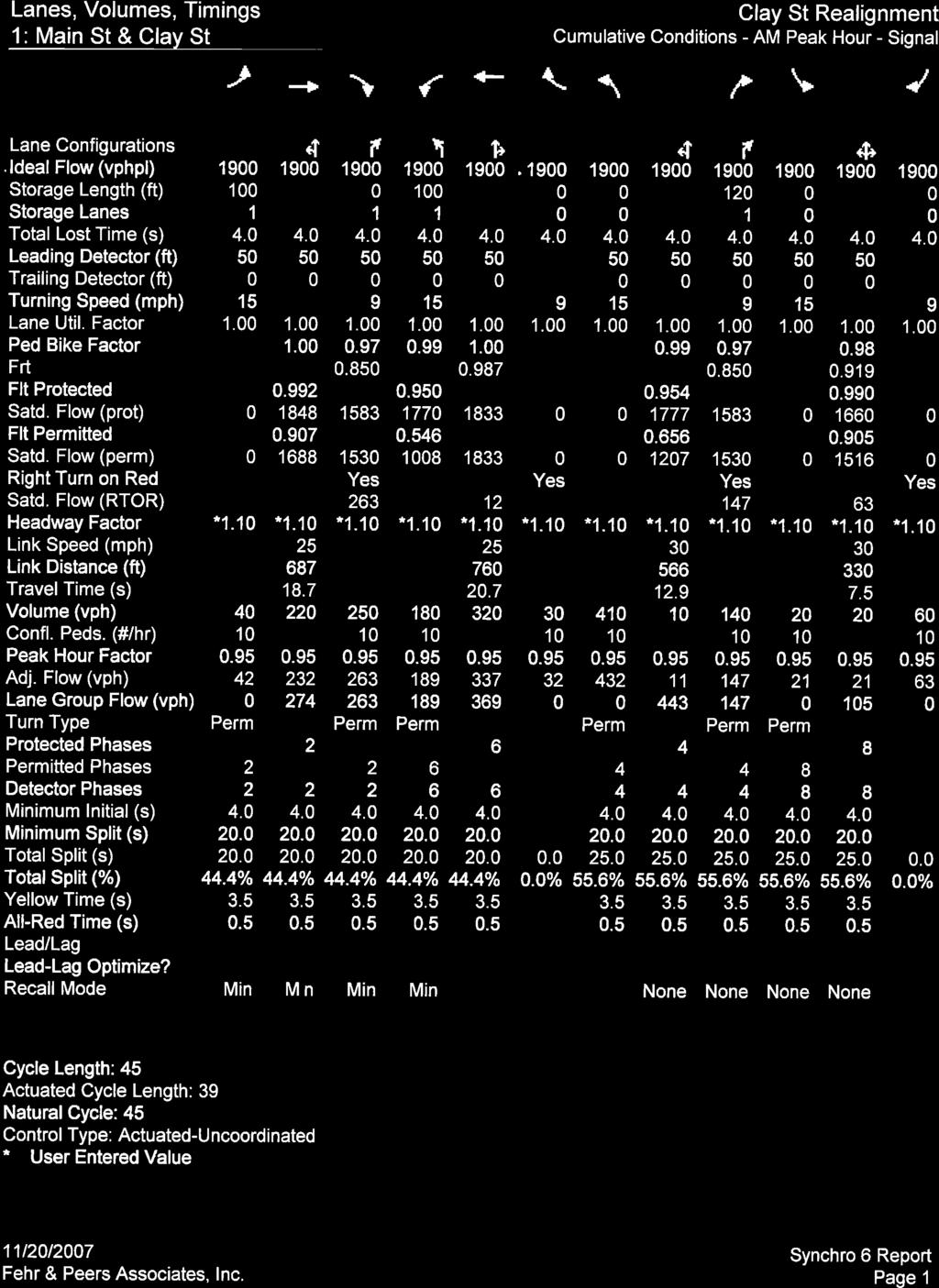
6 Clay Street Realignment Project Traffic Study Draft Report November 24, INTRODUCTION BACKGROUND This traffic study analyzes existing and future conditions for the intersections of Main Street at Clay Street and Main Street at Cedar Ravine Road in downtown Placerville. The project proposes to shift the Main Street / Clay Street intersection to the east to create a four-legged intersection at the existing Main Street / Cedar Ravine Road intersection. The new intersection configuration was evaluated under both roundabout and signal control. This traffic study is part of a preliminary engineering feasibility study to evaluate roadway realignment and the Hangtown Creek bridge replacement. Figure 1 illustrates the transportation system near the project area. Main Street runs east-west through downtown Placerville and parallel to U.S. Highway 50 (US 50). West of the study intersections, motorists can access US 50 at four locations. Canal Street, Spring Street, and Bedford Avenue are full-access signalized intersections at US 50. Center Street at US 50 provides eastbound right-in right-out access only. The US 50 / Mosquito Road / Broadway and US 50 / Schnell School Road interchanges are to the east of the study intersections. Main Street carries approximately 11,600 vehicles a day, nearly 10 percent, occurs during the PM peak hour. In combination with Broadway, Main Street is the only continuous local roadway through Central Placerville. Onstreet parallel parking, pedestrian crossings, and the lack of turn lanes at side streets and driveways influence the carrying capacity of Main Street. The limited capacity of upstream intersections, namely Bedford Avenue / Main Street and the US 50 / Mosquito Road / Broadway interchange, constrain the volumes that reach the study intersections. Clay Street is one of four 1 grade-separated US 50 crossings serving Central Placerville. Clay Street primarily serves residential properties to the north of US 50, crossing under US 50 and terminating at Main Street. Cedar Ravine Road intersects Main Street approximately 150 feet east of Clay Street. Given the close proximity of the Clay Street and Cedar Ravine Road intersections, queues from the all-way stop control at Main Street / Cedar Ravine Road routinely extend through the Clay Street intersection. In addition, eastbound Main Street left-turn vehicles at Clay Street block eastbound through traffic while waiting for an adequate gap to complete the turn. As a result, southbound Clay Street vehicles have few opportunities to turn left onto Main Street during the PM peak period. Downtown Placerville has limited available parking. Surface parking lots and on-street parking are adjacent to the study intersections. Project alternatives have been developed with the intention of minimizing parking impacts. The El Dorado Trail, a Class I bike path, begins at Clay Street on the north side of Hangtown Creek and continues east to Camino. The trail alignment to the west is undeveloped, although it is currently used as a construction staging area for the US 50 Operational Improvements Project. 1 The other three grade-separated crossings are Locust Avenue, Main Street, and Carson Road. All are located east of Clay Street. 1
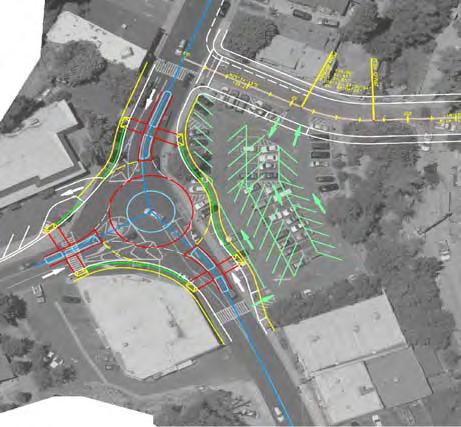
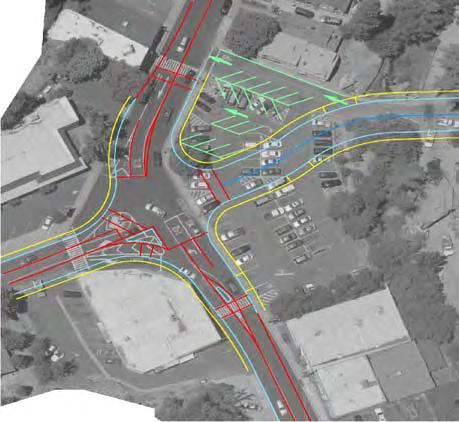
7 Clay Street Realignment Project Traffic Study Draft Report November 24, 2009 PROJECT DESCRIPTION The proposed project would realign Clay Street with Cedar Ravine at Main Street to create a four-legged intersection. A preliminary engineering feasibility study is currently being prepared to evaluate roadway realignment, Clay Street Bridge replacement, and relocation of a statue in the center of the Main Street / Cedar Ravine Road intersection. This project is intended to improve roadway safety, reduce congestion, and meet current and future traffic needs. Four alternatives have been identified for traffic analysis. Traffic operations were analyzed for the following four alternatives under cumulative (2025) conditions. Alternative 1: Roundabout (3-Legged) Construct a three-legged roundabout at Main Street / Cedar Ravine Road and maintain side-street stop control at Main Street / Clay Street. A driveway exists within the circulatory roadway that allows right-in entrance only access to the parcel on the southwest corner of the intersection. Alternative 2: Roundabout Realign Clay Street and construct a four-legged roundabout at Main Street / Cedar Ravine Road. A driveway exists within the circulatory roadway that allows right-in entrance only access to the parcel on the southwest corner of the intersection. Alternative 3: No Project Maintain all-way stop at Main Street / Cedar Ravine Road and side-street stop control at Main Street / Clay Street. Alternative 4: Signal Realign Clay Street and construct a four-legged signalized intersection at Main Street / Cedar Ravine Road. Figure 2 illustrates the alternatives under consideration. REPORT OUTLINE The next section of this report describes the traffic analysis methodology. The third section describes existing traffic operations in the study area. The last section covers the analysis of cumulative (2025) conditions and the effectiveness of the proposed project alternatives. 2
8 Schnell School Rd.!! Mosquito Rd. Clay St. Carson Rd.!!!!!!!!!!!!!!!!!!!!!!!!!!!!!!!!!!!!!! Broadway!!!! Locust Ave.!!!!!!!!!!!!!!!! Spanish Ravine Rd. Main St. Washington St. Cedar Ravine Rd.!! Clay St. Bedford Ave. Coloma St Canal St. Spring St. Center St, Sacramento St. N:\2007Projects\2466_Clay_Street_Realignment\GIS\draft\fig01_study_loc.mxd tu 50 Hangtown Creek LEGEND!!! Existing Class I Bike Path (El Dorado Trail) N Study Area NOT TO SCALE STUDY LOCATION FIGURE 1
9
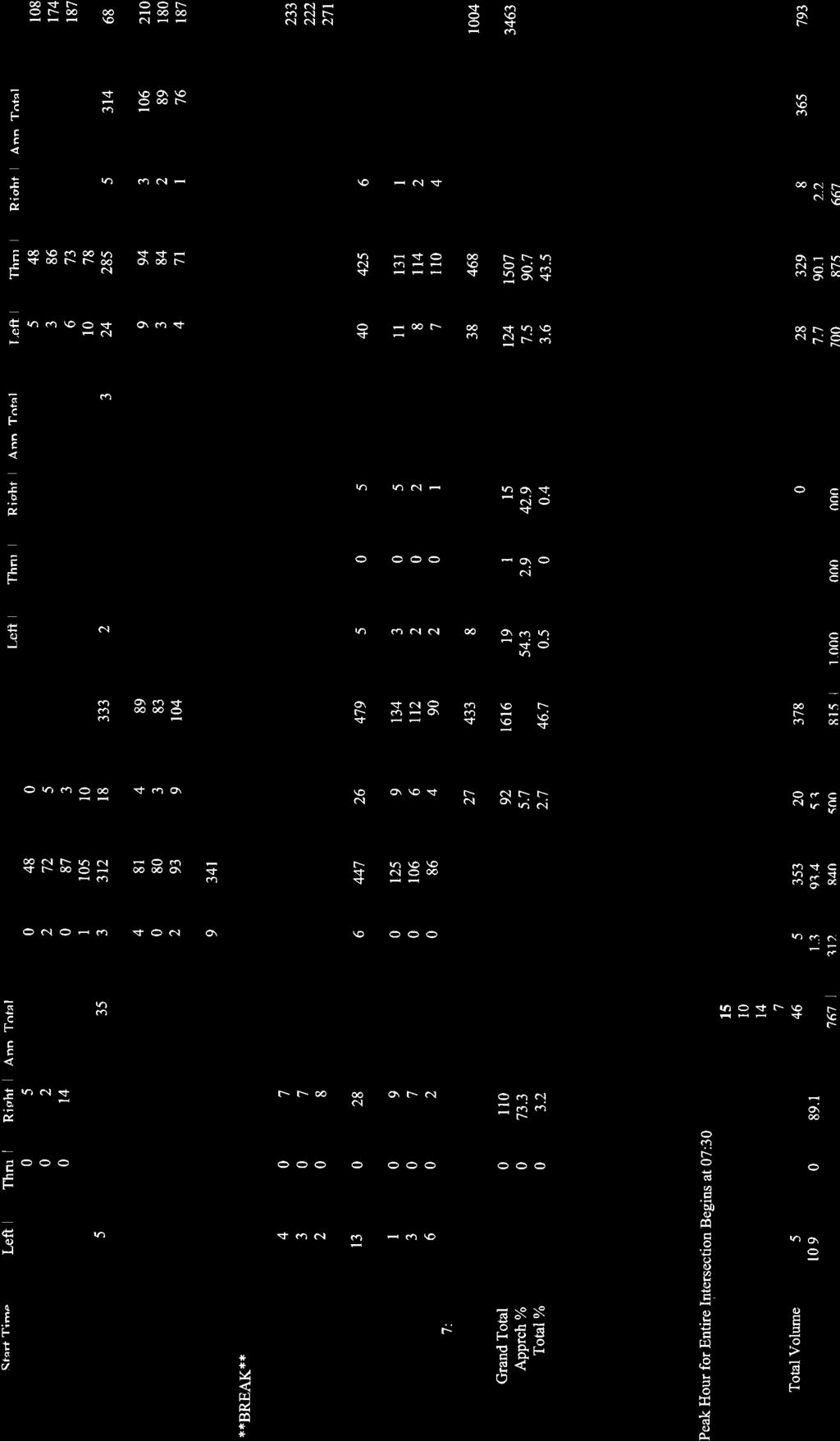
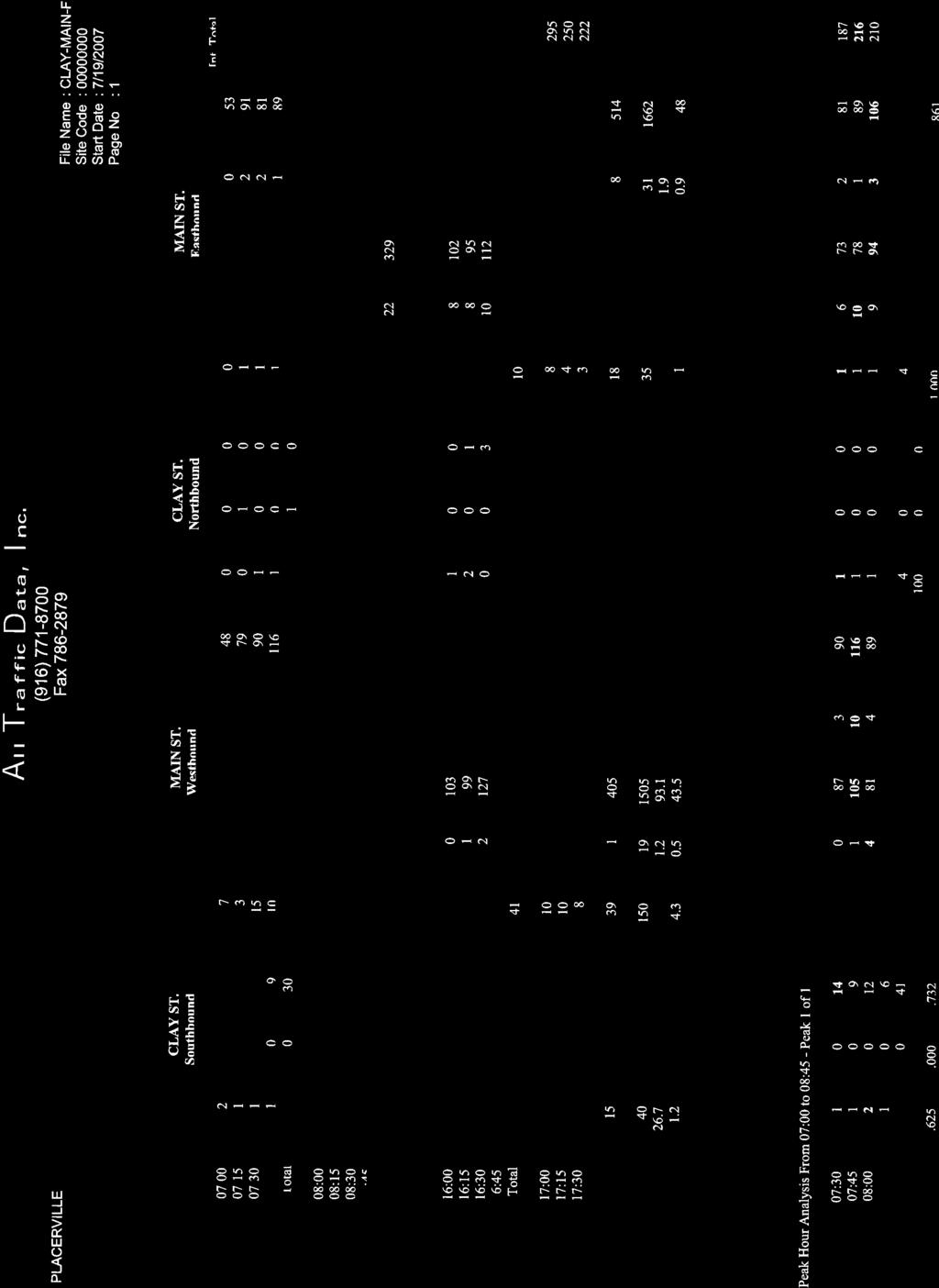
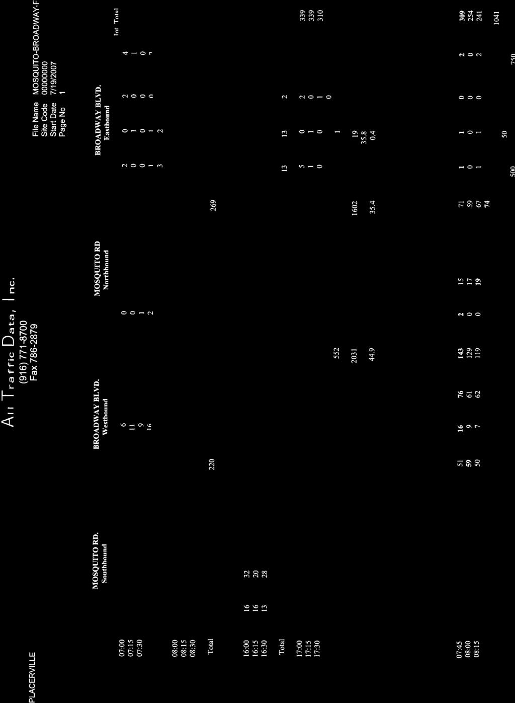
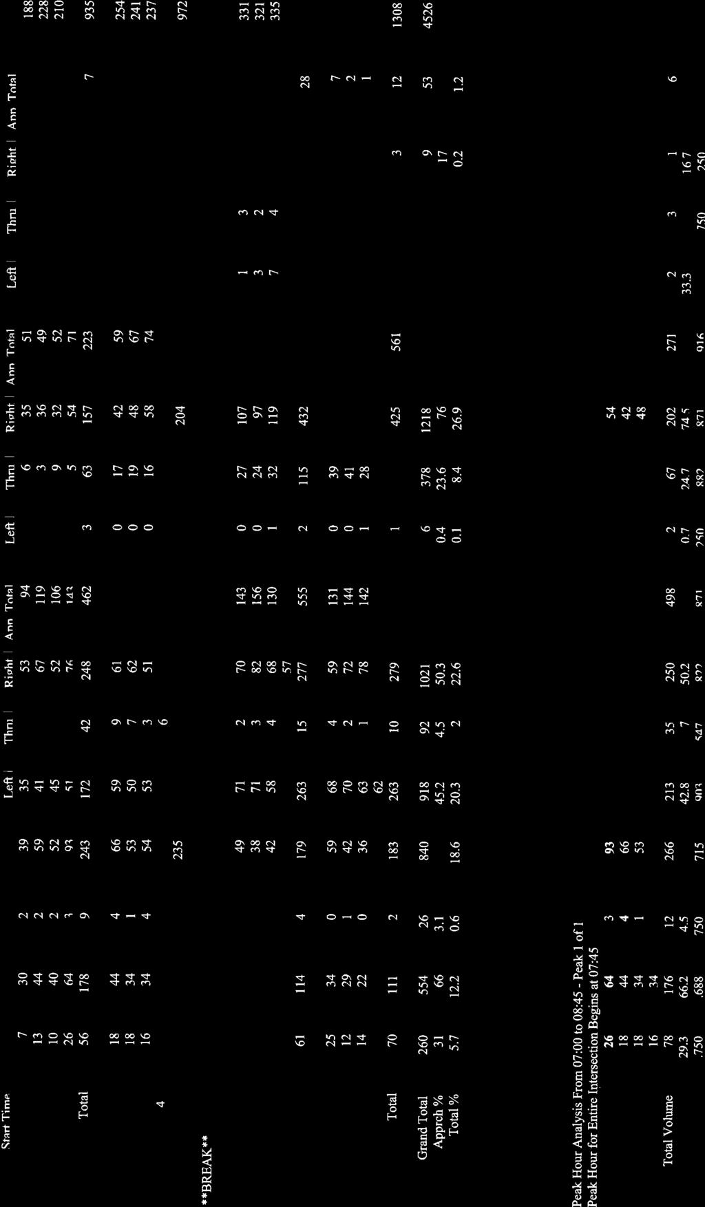
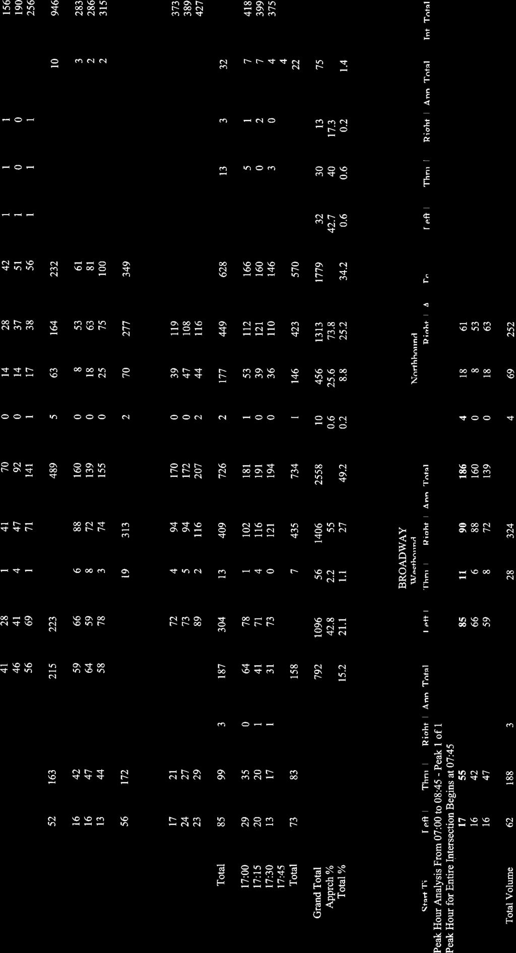
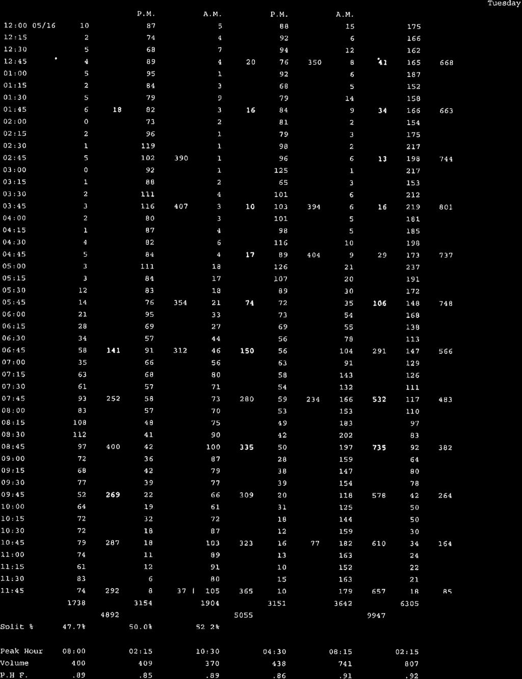
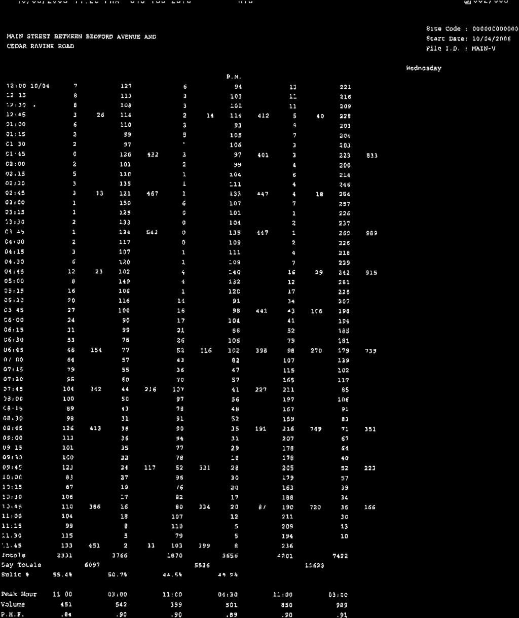
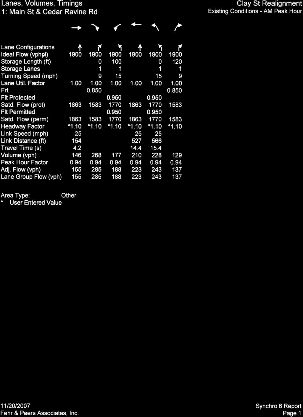
10 Clay Street Realignment Project Traffic Study Draft Report November 24, ANALYSIS METHODOLOGY DATA COLLECTION Morning (7:00 9:00 AM) and evening (4:00 6:00 PM) peak period traffic counts were collected at the Clay Street / Main Street and Cedar Ravine Road / Main Street intersections. The system peak hours were identified as 7:30 to 8:30 AM and 4:30 to 5:30 PM, respectively. The peak hour factors were measured as 0.94 and 0.89 for the AM and PM peak hours, respectively. A peak hour factor is the average volume during the peak 60 minute period divided by four times the average volume during the peak 15 minute period. The intersection turning movement traffic counts for Clay Street / Main Street and Cedar Ravine Road / Main Street were collected on Thursday, July 19, 2007, and Tuesday, June 12, 2007, respectively, when the local schools were not in session. As a result, the volumes are lower than would be expected at another time of the year. To account for this, we utilized available traffic counts at the Mosquito Road / Broadway intersection that were taken while school was in session. This intersection was used to determine how taking counts during the summer may underestimate the intersection volumes. The summer volumes were 15 percent lower during the AM peak period and 18 percent lower during the PM peak period compared to the counts collected in the spring. The Clay Street / Main Street peak hour intersection volumes were therefore increased using these percentages to estimate the higher in-school volumes. Figure 3 presents the existing intersection traffic control, lane configurations, and peak hour traffic volumes for both locations. Daily traffic counts were available from previous traffic studies and are summarized in Table 2. Appendix A contains traffic count data used for this study. TABLE 2 AVERAGE DAILY TRAFFIC VOLUMES Street Segment Total Volume 1 Date(s) Collected Cedar Ravine Road South of Main Street 10,250 May 16 17, 2006 Clay Street North of Main Street 1,030 May 24 25, 2006 Main Street Between Bedford Avenue and Clay Street 11,620 October 4, 2006 Note: 1. Total volume is measured in vehicles per day. Source: Fehr & Peers, 2006 TRAFFIC OPERATIONS Traffic operations at the study intersections are described using the qualitative term level of service (LOS). LOS is presented on a scale from A to F, with LOS A representing free-flow traffic conditions and LOS F representing heavily congested conditions. LOS is a qualitative measure of a number of factors on traffic conditions, including speed, travel time, traffic delay, freedom to maneuver, safety, driving comfort, and convenience. The study intersections were analyzed using procedures consistent with the Highway Capacity Manual (Transportation Research Board, 2000). Table 3 presents the Highway Capacity Manual s (HCM) delay 5
11 Clay Street Realignment Project Traffic Study Draft Report November 24, 2009 thresholds for unsignalized and signalized intersections that were used to evaluate LOS for the study intersections. The LOS for side-street stop-controlled intersections is based on the control delay of the worst stopcontrolled movement for the minor street. The LOS calculations for all-way stop-controlled and signalized intersections uses average control delay for all approaches. The LOS reported at roundabout intersections reflects the worst approach. TABLE 3 INTERSECTION LOS THRESHOLDS Average Control Delay 1 LOS Signal Unsignalized A < 10 < 10 B > 10 to 20 > 10 to 15 C > 20 to 35 > 15 to 25 D > 35 to 55 > 25 to 35 E > 55 to 80 > 35 to 50 F > 80 > 50 Note: 1. Average delay is measured in seconds per vehicle. Source: Highway Capacity Manual (Transportation Research Board, 2000) SimTraffic, a software program capable of simulating traffic operations, was used to identify LOS for each study intersection. SimTraffic captures the random nature of driver behavior and models the interaction between vehicles in a study network. Traffic simulation better accounts for delays under congested conditions including pedestrian crossings, queue blocking, and queue interactions between adjacent intersections when compared to traditional analysis methods. Since roundabouts are a relatively new form of intersection traffic control in the United States, existing analysis tools have not been fully tested. Given the potential limitations of SimTraffic for roundabout analysis, the roundabout alternatives were also evaluated using SIDRA, an Australian program typically used for roundabout capacity analysis. SimTraffic and SIDRA results were also compared against planning-level analyses from FHWA s roundabout guidelines, the Highway Capacity Manual (2000), and NCHRP 572, a recently released study of existing American roundabouts. The following assumptions were used to calculate intersection operations under existing and cumulative (2025) conditions. The heavy vehicle (truck) percentage was set to two percent. The measured peak hour factors of 0.94 and 0.89 were applied for the existing conditions analysis of the AM and PM peak hours, respectively. A peak hour factor of 0.95 was utilized for the cumulative traffic analysis for both AM and PM peak hours. For the signal alternative, two pedestrian calls (i.e., pedestrian push button actuations) per hour were assumed for each through phase of the signal. Ten conflicting pedestrians per hour were assumed for intersection left and right turn movements. 6
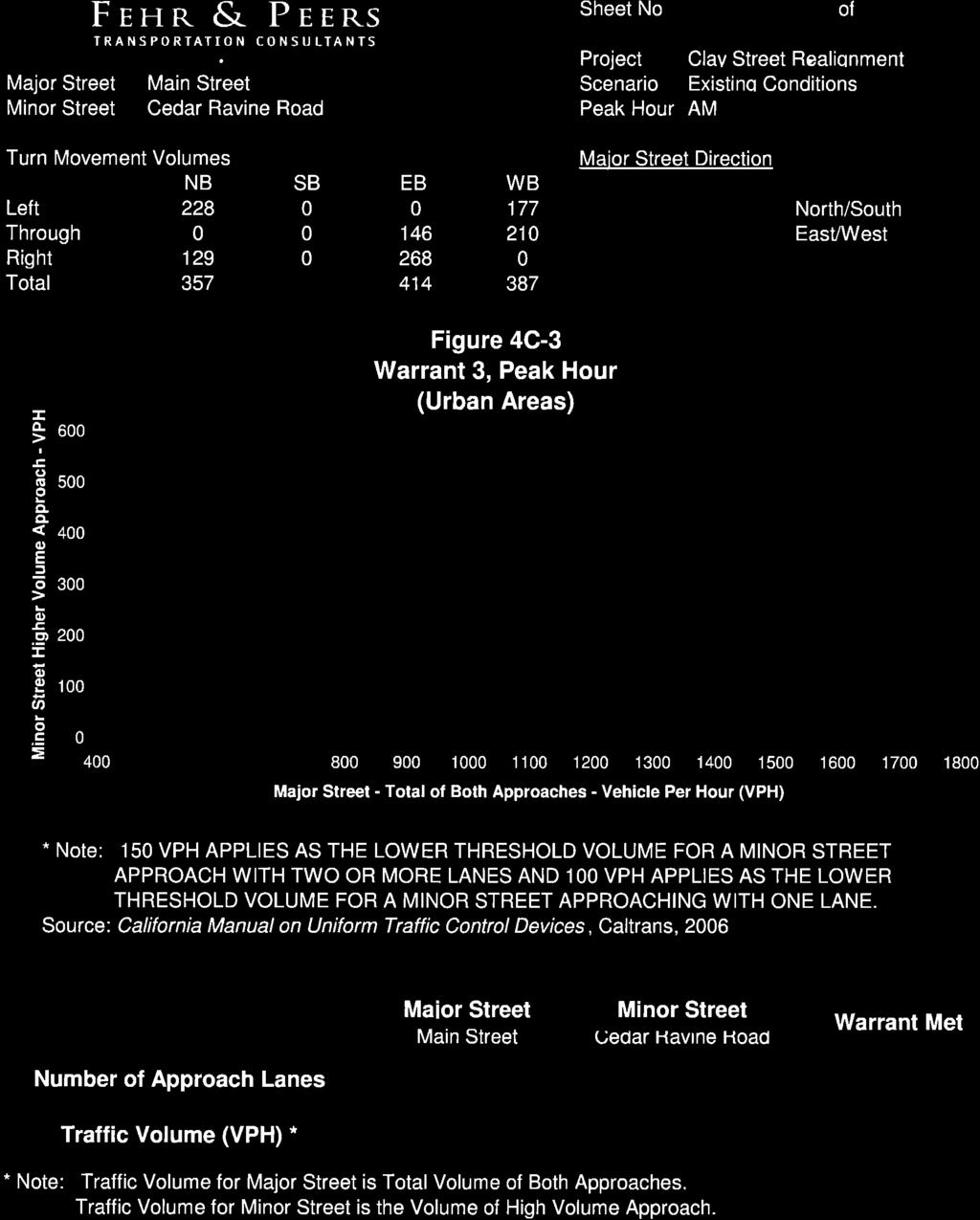
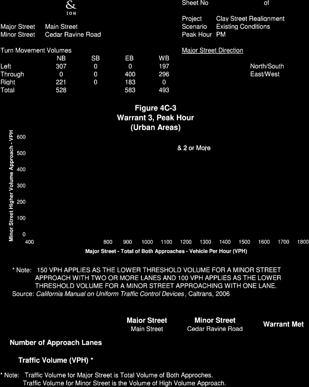
12 Clay Street Realignment Project Traffic Study Draft Report November 24, 2009 SIGNAL WARRANT ANALYSIS The peak hour volume traffic signal warrant was evaluated as defined in the California Manual on Uniform Traffic Control Devices (Caltrans, 2006). The intersection of Main Street / Cedar Ravine Road meets the peak hour warrant during both peak hours. Appendix B contains the warrant worksheets. Since the existing peak hour volumes are less than 100 vehicles per hour on the minor street (i.e., the lower threshold volume), the Main Street / Clay Street intersection does not meet the peak hour signal warrant. Given the short distance between the two intersections (i.e., less than 150 feet), operational impacts need to be assessed as a system rather than in isolation. While this analysis indicates the potential need for a traffic signal at Main Street / Cedar Ravine Road, it should not serve as the only basis for deciding whether and when to install a signal or other form of intersection control. Prior to installing a traffic signal, the City s Traffic Engineer should conduct a detailed safety analysis and engineering study to justify installation. Traffic signal benefits versus cost, safety, and operational consequences need to be carefully considered. Warrants have not yet been established for roundabout intersections; therefore, an equivalent analysis is not possible. EVALUATION CRITERIA The City of Placerville General Plan Policy Document identifies the following goal and objective pertaining to level of service. Goal A: To provide a circulation system that is correlated and adequate to support existing and proposed land uses, thereby providing for the efficient movement of goods and services within and through Placerville. Policy A.1: The City shall strive to attain the highest possible traffic levels of service consistent with the financial resources available and within the limits of technical feasibility. This analysis strives to achieve LOS D or better conditions. 7
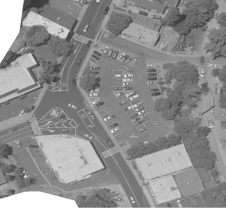
13 Clay Street Realignment Project Traffic Study Draft Report November 24, EXISTING CONDITIONS STUDY AREA The study area includes the following two study intersections. 1. Cedar Ravine Road / Main Street 2. Clay Street / Main Street The traffic volumes that reach the study intersections are constrained by the limited capacity of upstream intersections, namely Bedford Avenue / Main Street and the US 50 / Mosquito Road / Broadway interchange. The following roadways provide access in the study area. Main Street is an east-west roadway that runs from Forni Road through downtown Placerville to the US 50 / Mosquito Road / Broadway interchange to the east. Main Street runs south of, and parallel to, US 50. The intersections at Bedford Avenue, Cedar Ravine Road, and Mosquito Road have all-way stop control. Main Street has two through lanes with on-street parking west of Clay Street and multiple mid-block pedestrian crossings. East of Cedar Ravine Road, parking is restricted on the south side and near the intersection in both sides. Main Street was recently rehabilitated to improve drainage and surface conditions in the study area. Cedar Ravine Road is a two-lane north-south roadway linking Main Street to Pleasant Valley Road near Bucks Bar Road. South of downtown Placerville, Cedar Ravine Road narrows to a rural, mountainous roadway. Clay Street is a circuitous two-lane collector roadway primarily serving residential properties north of US 50. Clay Street begins at Main Street on the west, crosses under US 50 and terminates at Mosquito Road on the east. Clay Street is one of four grade-separated US 50 crossings serving Central Placerville. Clay Street intersects Main Street approximately 150 feet west of Cedar Ravine Road. A driveway to a parking lot on the south side of Main Street serves as the fourth leg to the Main Street / Clay Street intersection. Parking is permitted along the east side on Clay Street north of Hangtown Creek and on both sides of the street north of US 50. North of Coleman Street, the demand for parking diminishes, and consequently the roadway has been improved to a twolane roadway with raised vertical curbs that preclude on-street parking. A 15-foot monument on a granite foundation in the center of the Main Street / Cedar Ravine Road intersection limits traffic control options. The intersection is currently all-way stop controlled with eastbound Main Street right turns having yield control. Sight distance is limited on the intersection approaches due to little or no building setbacks and a skewed intersection alignment. Convenient parking is limited in downtown Placerville. Surface parking lots and on-street parking with a two-hour limit are provided adjacent to the study intersections. In particular, the City-owned Ivy House Parking Lot exists on the north side of Main Street between Clay Street and Cedar Ravine Road. Depending on the project alternative, on-street and/or off-street parking capacity will be affected to some degree. 8
.")
 Not Met PM F / >50 (SBL) Not Met Notes: Bold and underline font")
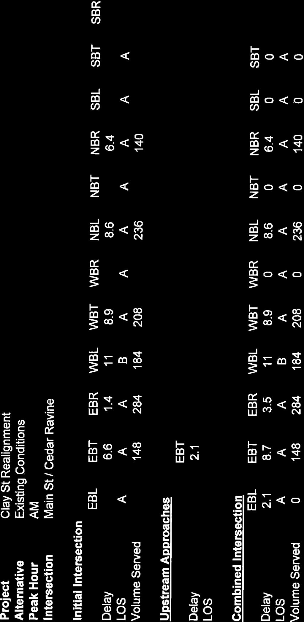
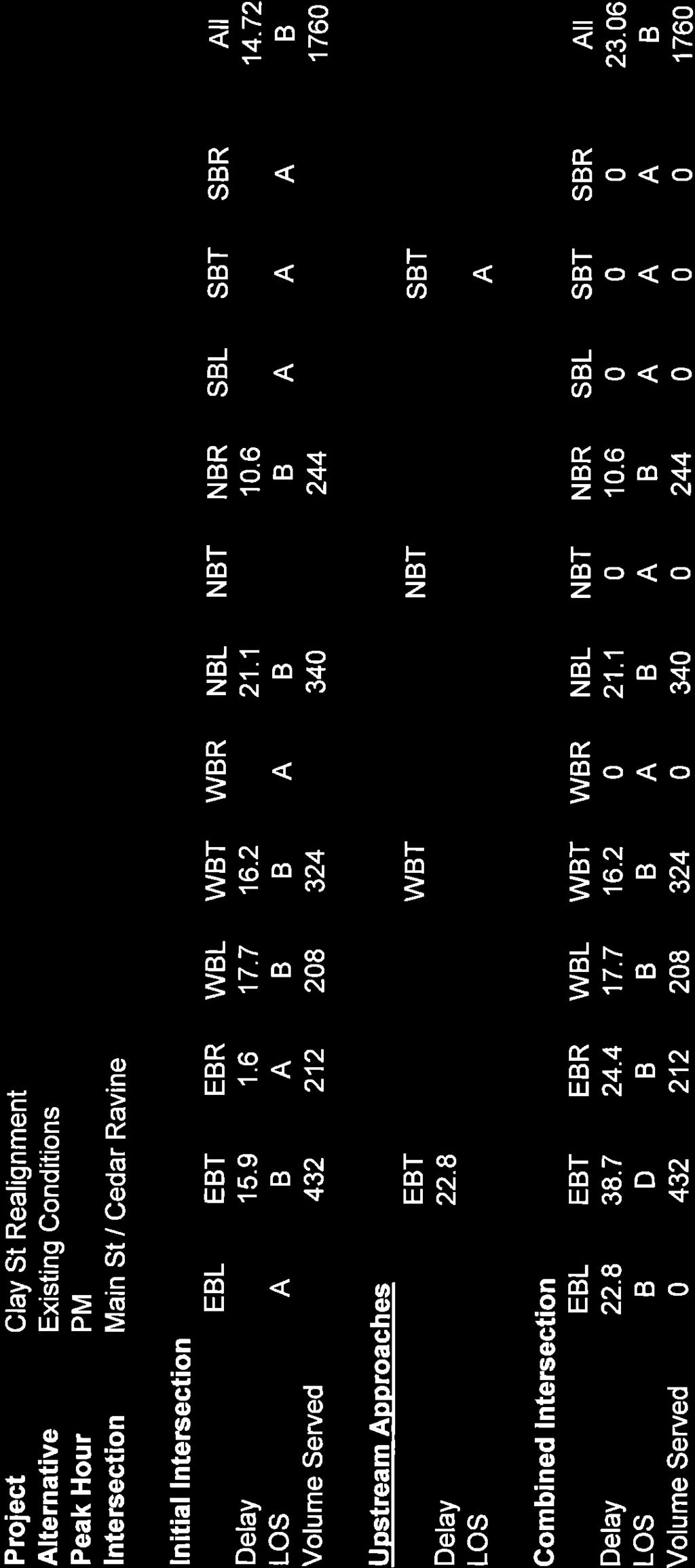
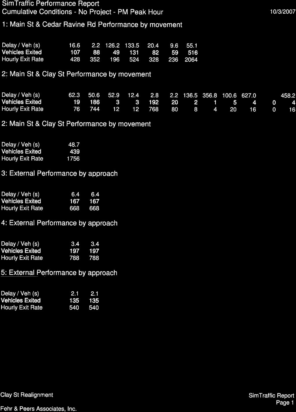
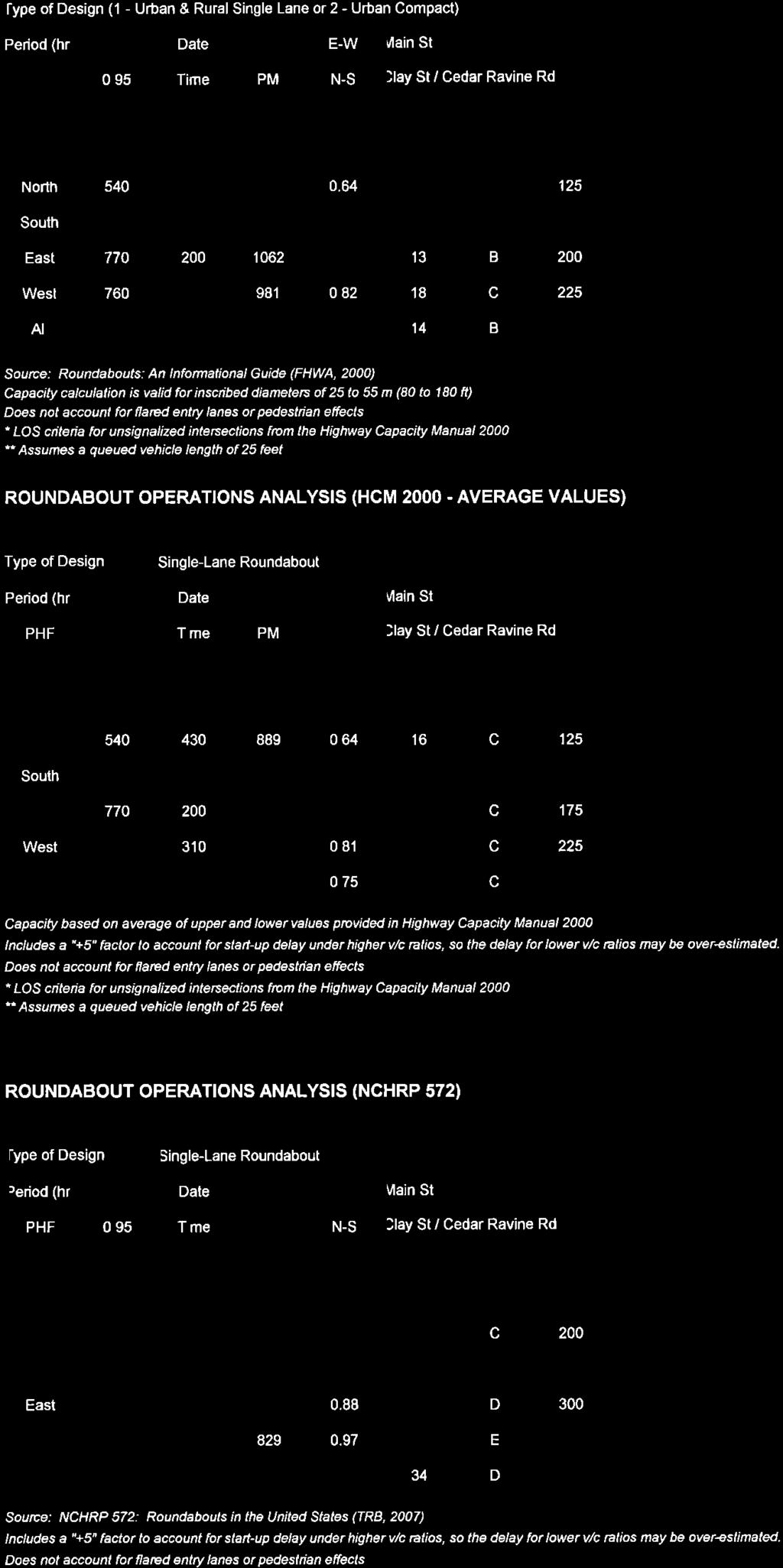
14 Clay Street Realignment Project Traffic Study Draft Report November 24, 2009 OPERATIONS ANALYSIS Figure 3 shows the peak hour traffic volumes, lane configurations, and traffic control for existing conditions at the study intersections. Table 4 lists the LOS and delay for each study intersection (see Appendix C for detailed analysis results). TABLE 4 EXISTING PEAK HOUR OPERATIONS ANALYSIS Intersection Control Peak Hour 1. Main Street / Cedar Ravine Road All-Way Stop 2. Main Street / Clay Street Side-Street Stop LOS / Average Delay 1 Peak Hour Signal Warrant 2 AM A / 8 Met PM C / 23 Met AM C / 18 (SBL) Not Met PM F / >50 (SBL) Not Met Notes: Bold and underline font indicate LOS F conditions. SBL = Southbound left turn 1. The table lists the LOS (level of service) and average delay (measured in seconds per vehicle) for each intersection. For side-street stop-controlled intersections, the table shows the LOS and control delay for the worst movement. 2. For stop-controlled intersections, the peak hour volume traffic signal warrant was evaluated as defined in the California Manual on Uniform Traffic Control Devices (Caltrans, 2006). Source: Fehr & Peers, 2007 Under existing conditions, southbound Clay Street operates at LOS F during the PM peak hour. Eastbound queues develop at the Main Street / Cedar Ravine Road intersection that occasionally extend through the Main Street / Clay Street intersection (see Exhibits 1 and 2). Traffic turning left from eastbound Main Street to Clay Street blocks eastbound through traffic while waiting for an adequate gap in westbound traffic to complete the turn. As a result, southbound Clay Street left-turn traffic has few gaps in which to complete the turn during the PM peak hour. The southbound Clay Street delay is less during the AM peak hour since conflicting traffic volumes are relatively low. Exhibit 1 Eastbound Main Street at Cedar Ravine Road Exhibit 2 Eastbound Main Street traffic queue at Clay Street / parking lot 9
15
. Although the intersection operates at LOS C during the PM peak hour, the eastbound approach operates at LOS E given the influence of the adjacent Clay Street intersection (i.e., delays incurred by eastbound volume in combination with lane blockage).")
 and two others appear to be parking related (e.")
16 Clay Street Realignment Project Traffic Study Draft Report November 24, 2009 The Main Street / Cedar Ravine Road intersection operates acceptably under existing traffic control during both peak hours (see exhibits 3 and 4). Although the intersection operates at LOS C during the PM peak hour, the eastbound approach operates at LOS E given the influence of the adjacent Clay Street intersection (i.e., delays incurred by eastbound volume in combination with lane blockage). Exhibit 3 Looking southeast from north side of Main Street at Cedar Ravine Road Exhibit 4 Northbound Cedar Ravine Road at Main Street monument and building setback Accident data was provided by the City for January 2004 through September Ten total accidents have occurred. Three were single vehicle collisions with fixed objects (e.g., median, light pole) and two others appear to be parking related (e.g., hitting parked car while parking or turning from a driveway). The remaining five accidents were rear-end accidents occurring at the intersections. It is not known if any accidents resulted in injuries. Seven of the ten accidents occurred in 2007, which suggests that the accident rate is increasing. BICYCLE, PEDESTRIAN, AND TRANSIT FACILITIES Transit services are provided by El Dorado County Transit Authority. Multiple routes (e.g., Placerville Express, Placerville East, and Placerville West) cross through the study area. All operate on weekdays with one-hour headways between roughly 7:00 AM and 6:00 PM. The El Dorado County Transportation Commission recently began a five-year Short Range Transit Plan for Western El Dorado County, which may include changes to route alignment or frequency through the study area. Main Street is the most direct path between two transit centers: the Placerville Station Transfer Center and the Missouri Flat Transfer Center. Both Cedar Ravine Road and Main Street have existing 4-foot sidewalks near the study intersections. East of Cedar Ravine, Main Street sidewalks have been recently improved. Clay Street has a 4-foot sidewalk on the west between Hangtown Creek and Main Street; however, the sidewalk grade is at roadway level, which provides no vertical separation for pedestrians (see Exhibit 5). The east side of Clay Street has no sidewalk south of the creek. North of the creek, raised sidewalks exist on both sides for a short distance through the US 50 under crossing, after which the sidewalk on the west side terminates but continues on the east (see Exhibit 6). Ladder-striped marked crosswalks exist on all three roadways, approximately 75 to 100 feet before the STOP lines at the Main Street / Cedar Ravine Road intersection (see Exhibits 7 and 8). 11


.")

17 Clay Street Realignment Project Traffic Study Draft Report November 24, 2009 Exhibit 5 Looking southbound on Clay Street Exhibit 6 Northbound Clay Street towards Main Street at US 50 Exhibit 7 Marked crosswalk on Cedar Ravine Road south of Main Street Exhibit 8 Marked crosswalk on Main Street at Clay Street The El Dorado Trail, a Class I bike path, begins at Clay Street on the north side of Hangtown Creek and continues east to Camino. The trail alignment to the west is undeveloped and is currently used as a construction staging area for the US 50 Operational Improvements Project. The El Dorado Transportation Commission has identified this segment as the top priority segment 2 (see Exhibits 9 and 10). The study area does not have on-street Class II bicycle lanes. Sufficient right-of-way is not available to provide Class II bicycle lanes and maintain on-street parking on Clay Street, Cedar Ravine Road, or on Main Street west of Clay Street. 2 Prioritized Class I Bike Path Segments The El Dorado Trail / SPTC graphic available on the following Web site: 12


18 Clay Street Realignment Project Traffic Study Draft Report November 24, 2009 Exhibit 9 Existing Class I trail looking east from Clay Street Exhibit 10 Proposed Class I alignment looking west from Clay Street 13
19 Clay Street Realignment Project Traffic Study Draft Report November 24, CUMULATIVE CONDITIONS TRAFFIC FORECASTS The design year traffic forecasts for the study intersections were developed using the travel demand forecasting (TDF) model developed for the City of Placerville Traffic Impact Fee Study. A review of the TDF model output revealed that decreases were forecasted on certain turning movements at the Cedar Ravine Road / Main Street intersection along with large increases in the east and west through movements. This can be attributed to high forecasted traffic volume on US 50, which causes traffic to divert to Broadway and Main Street. However, the traffic that diverts was too high given intersection capacity in the downtown area. The model was adjusted to make Broadway a less attractive path so that the diversion from US 50 would be less. Both the base year and cumulative year models required network updates. Neither scenario included the existing US 50 ramps on Broadway east of the project. The existing westbound on-ramp, westbound off-ramp, and eastbound off-ramp were added, but the closed eastbound on-ramp was not included. Additionally, the US 50 operational improvements now under construction were added to the model. These improvements include the extension of Placerville Drive to Main Street and the addition of the third eastbound lane on US 50 from Canal Street through Bedford Avenue. The raw traffic volume forecasts for the base and cumulative year model runs were adjusted to account for model error. The adjustment process involved calculating the difference between the base model volume estimate and the cumulative model volume forecast. This growth increment was added to the recent counts obtained at the study intersections to develop adjusted cumulative year forecasts. This adjustment recognizes that models are effective at forecasting changes but may not always perfectly match base year conditions. The growth increment was not reduced between 2005 and 2025 to account for traffic growth that may have occurred between the base year of 2005 and the 2007 counts. By not reducing the increment, the potential for underestimating future traffic volumes is minimized. Figures 4 through 7 show the peak hour traffic volumes, lane configurations, and traffic control for cumulative (2025) conditions for the four study alternatives. The movements with the highest volume growth are on northbound Cedar Ravine Road during the AM peak hour (57 percent) and westbound Main Street during the PM peak hour (54 percent). 14
20
21
22
23
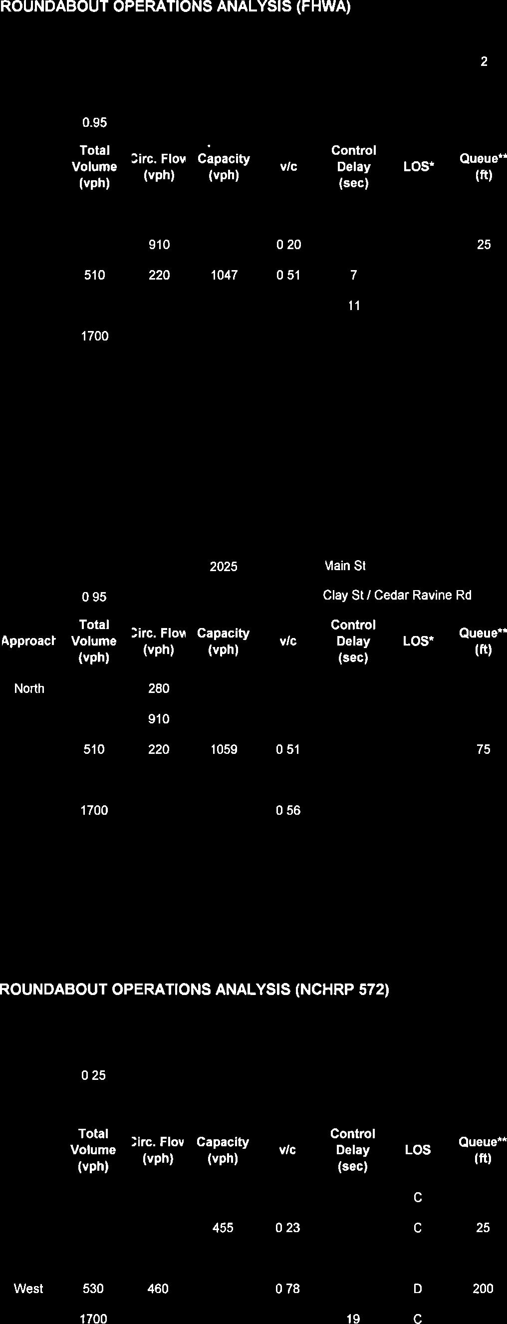
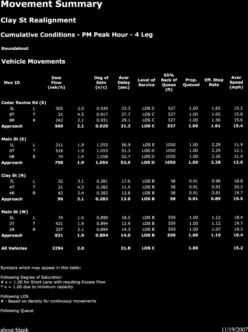
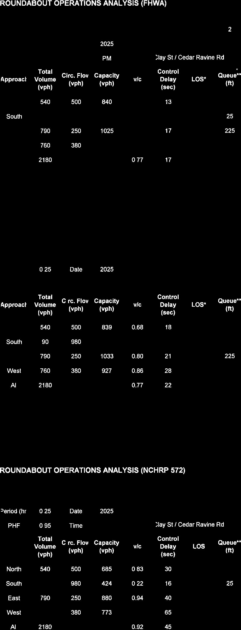
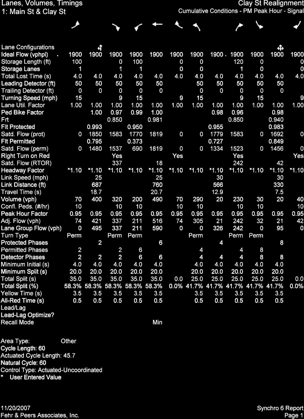
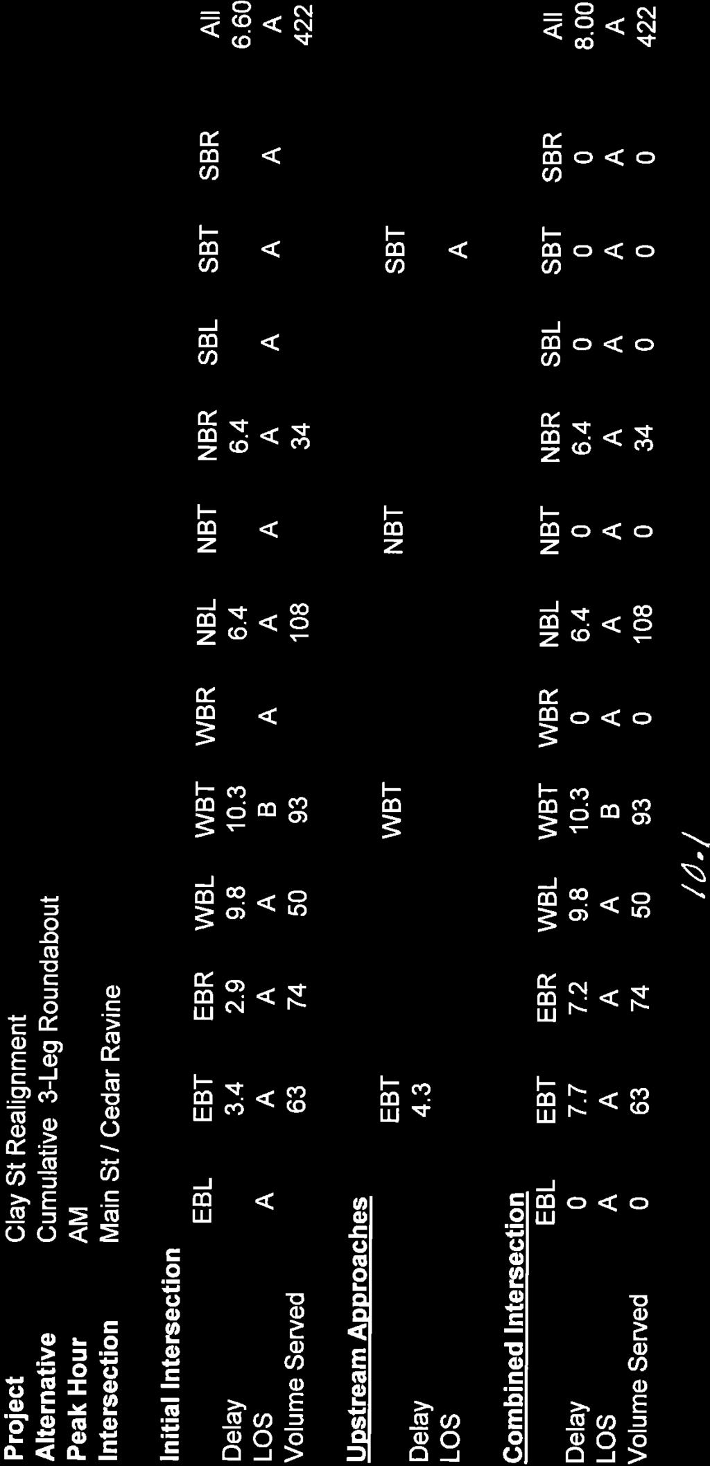
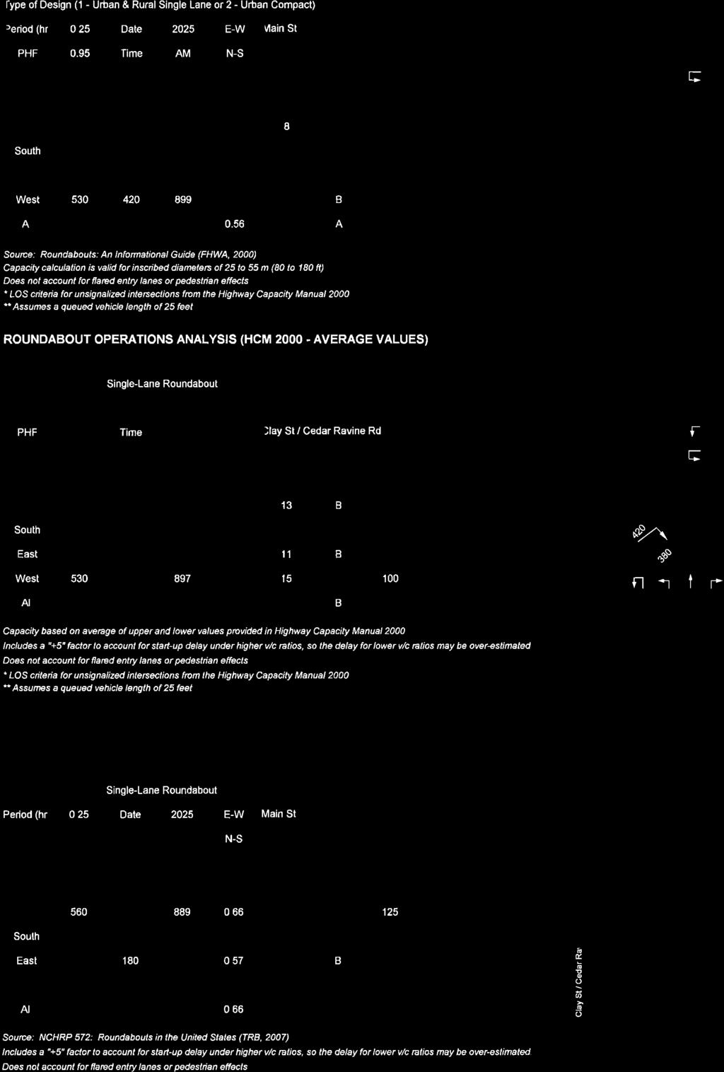
24 Clay Street Realignment Project Traffic Study Draft Report November 24, 2009 OPERATIONS ANALYSIS The operations analysis for cumulative conditions used the SimTraffic model developed for the existing conditions analysis and the additional roundabout analysis tools described in Section 2. Intersection operations were analyzed for the four alternatives under cumulative (2025) conditions. The cumulative analysis assumes an unconstrained traffic roadway network (i.e., all forecasted traffic enters the study intersections). In actuality, volumes may be metered or regulated by the capacity of upstream intersections or roadway segments, which would improve reported delay and LOS at the study intersections. Table 5 lists the LOS and delay by alternative (see Appendix D for detailed analysis results). TABLE 5 CUMULATIVE (2025) PEAK HOUR OPERATIONS ANALYSIS Intersection Control Peak Hour Delay 1 LOS Alternative 1: Roundabout (3-Legged) 1. Main Street / Cedar Ravine Road Roundabout 2. Main Street / Clay Street Side-Street Stop Alternative 2: Roundabout with Clay Street Realignment 1. Main Street / Cedar Ravine Road Roundabout Alternative 3: No Project 1. Main Street / Cedar Ravine Road All-Way Stop 2. Main Street / Clay Street Side-Street Stop Alternative 4: Traffic Signal with Clay Street Realignment 1. Main Street / Cedar Ravine Road Signal AM 10 (WB) A PM 31 (EB) D AM >50 (SBL) F PM >50 (SBL) F AM 11 (WB) B PM 18 (WB) C AM 20 C PM >50 F AM >50 (SBL) F PM >50 (SBL) F AM 23 C PM 60 E Notes: LOS = Level of service SBL = Southbound Left Turn WB = Westbound EB = Eastbound Bold and underline font indicate LOS F conditions. 1. The table lists average delay (measured in seconds per vehicle) for each intersection. At signalized and all- way stopcontrolled intersections, delay and LOS are based on average delay per vehicle for the overall intersection. At side-street stop-controlled intersections, delay and LOS are based on the worst stop-controlled movement from the side street. At roundabout intersections, delay and LOS are based on the worst approach. Source: Fehr & Peers,
25 Clay Street Realignment Project Traffic Study Draft Report November 24, 2009 A queue length analysis was also performed for the study alternatives. Queue lengths reported in Table 6 reflect the 95 percent queue length by approach reported in SimTraffic. For alternatives 1 and 3, the eastbound Main Street queues extend through the upstream Clay Street intersection. The reported values noted in bold in Table 6 below conservatively assume that the downstream queue at Clay Street is associated with the queue from the Main Street / Cedar Ravine Road intersection and have been accounted for in the reported queue length. Occasionally, an eastbound left turning vehicle on Main Street waiting for a gap to turn northbound on Clay Street will generate an eastbound queue independent of the Main Street / Cedar Ravine Road intersection. TABLE 6 CUMULATIVE (2025) PEAK HOUR 95% QUEUE LENGTH (FEET) Intersection Peak Hour Northbound Southbound Eastbound Westbound Alternative 1: Roundabout (3-Legged) 1. Main Street / Cedar Ravine Road 2. Main Street / Clay Street Alternative 2: Roundabout with Clay Street Realignment 1. Main Street / Cedar Ravine Road Alternative 3: No Project 1. Main Street / Cedar Ravine Road 2. Main Street / Clay Street Alternative 4: Traffic Signal with Clay Street Realignment 1. Main Street / Cedar Ravine Road AM PM AM PM AM PM AM PM 205-1,225 1,625 AM PM , AM PM Note: Bold and underline font indicates locations where the queue exceeds available storage and extends through the Clay Street intersection. Source: Fehr & Peers,
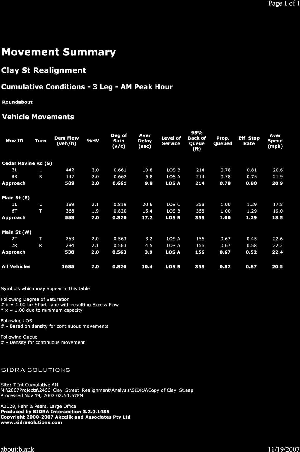
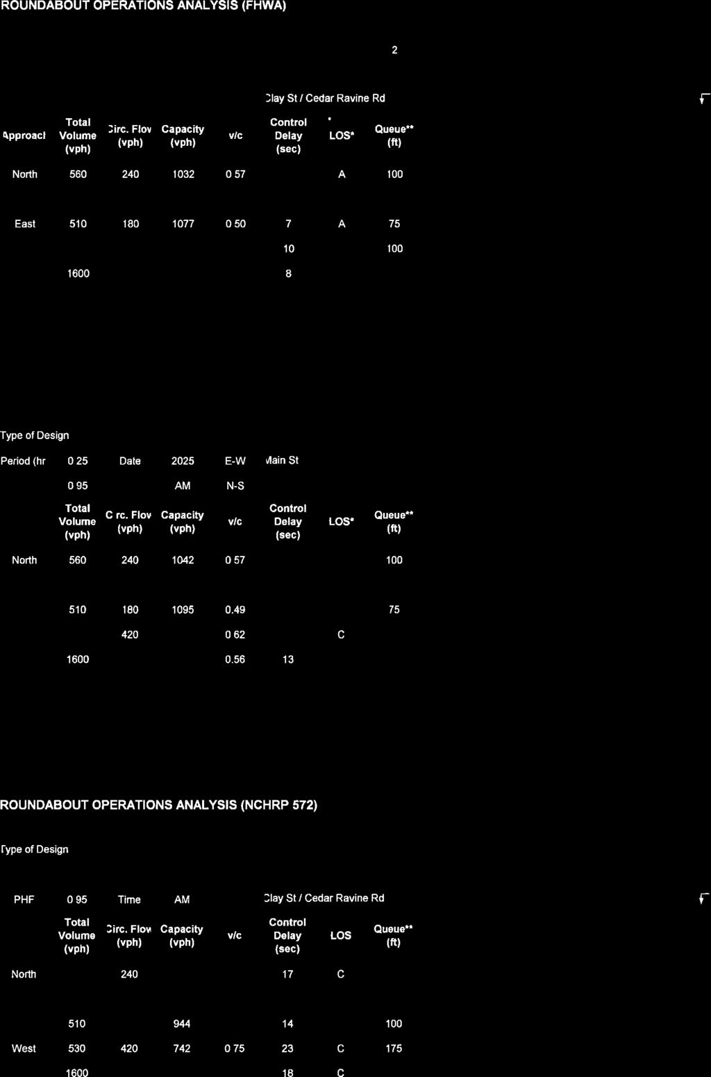
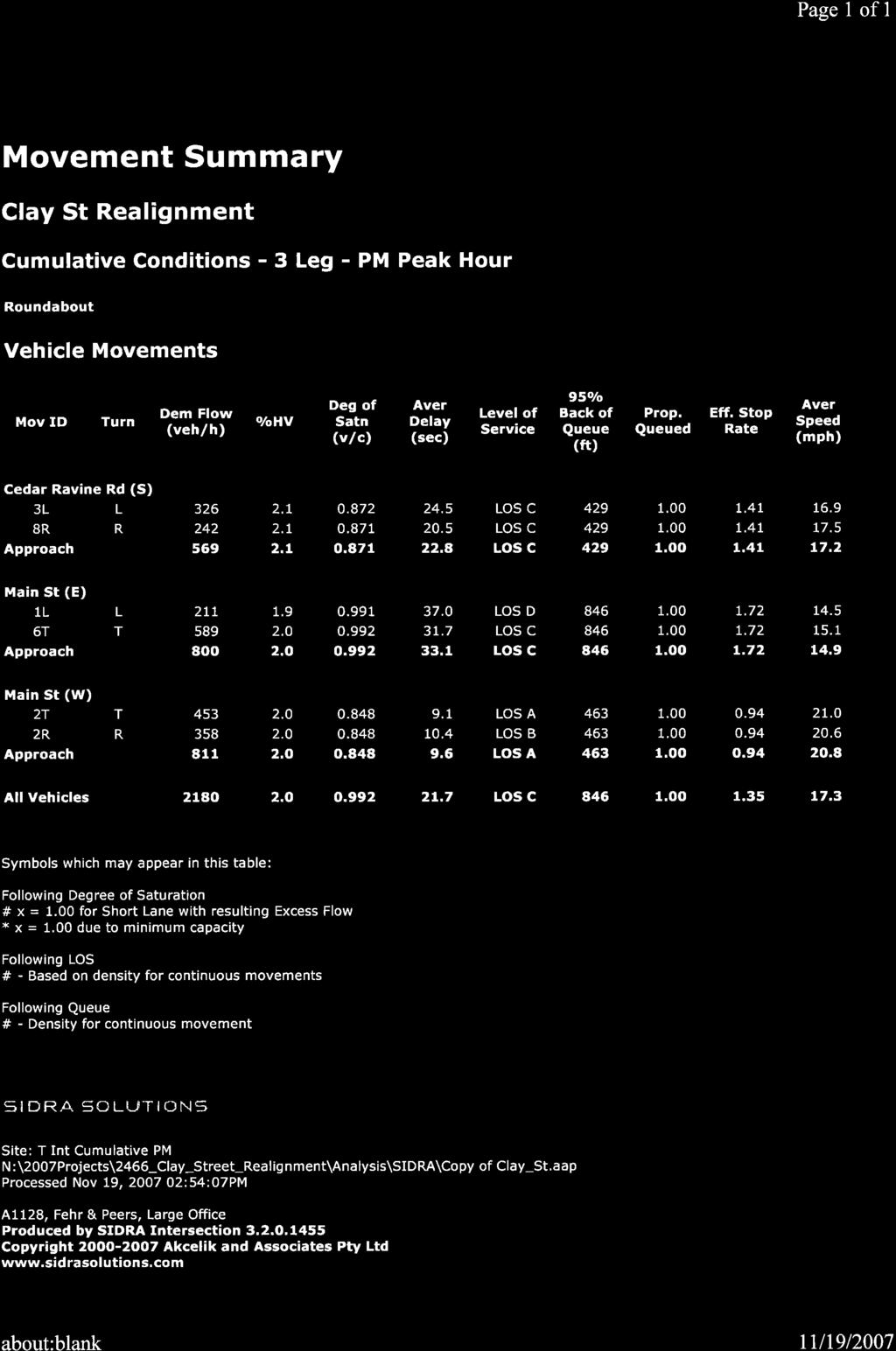
26 Clay Street Realignment Project Traffic Study Draft Report November 24, 2009 The following are key findings from the SimTraffic operations analysis. Alternative 3: No Project LOS F conditions would occur during both the AM and PM peak hours for southbound Clay Street at Main Street resulting in several minutes of delay. LOS F conditions would occur at Main Street / Cedar Ravine Road during the PM peak hour. The greatest delay would occur on the westbound approach. Alternative 2: Roundabout (with roadway realignment) LOS B and LOS C conditions are expected in the AM and PM peak hours, respectively. During the PM peak hour, the westbound approach would experience the highest delay. Alternative 4: Signal (with roadway realignment) LOS C conditions would occur during the AM peak hour. The overall intersection would operate at LOS E during the PM peak hour. The worst movement, the westbound left turn, would operate at LOS F. For comparison purposes, all-way stop control was also evaluated with the roadway realignment. Intersection operations would worsen to LOS F conditions with three to five minute delays. Alternative 1: Roundabout (3-Legged) Similar to No Project conditions, LOS F conditions and several minutes of delay would occur during the PM peak hour for southbound Clay Street at Main Street. During the PM peak hour, the Main Street / Cedar Ravine Road intersection would operate at LOS D, which is an improvement over No Project conditions. Given the traffic patterns in the study area, the three-legged roundabout (Alternative 1) would have longer delays than the four-legged roundabout (Alternative 2). Alternative 2 would have the best overall system LOS and lowest delay per vehicle compared to the other project alternatives. During all other hours including the AM peak hour, a roundabout would have lower delay than allway stop or signal control. The continuous flow in a roundabout allows vehicles to proceed without stopping if an adequate gap exists, whereas stop-control requires all vehicles to stop, and signal control requires some approaches to wait for a green indication before proceeding. To confirm the SimTraffic roundabout analysis results, additional analysis was conducted using SIDRA and compared against planning-level analyses from FHWA s roundabout guidelines, the Highway Capacity Manual (2000), and NCHRP 572, a recently released study of existing American roundabouts. SIDRA and NCHRP 572 tend to yield conservative results more representative of opening day (existing plus project conditions) due to American driver unfamiliarity with modern roundabouts. By design year conditions, drivers will have become more familiar with roundabouts which should lead to higher capacities that reflect the observed capacities in other countries. Table 7 contains the results of the comparative analysis for Alternative 1: Roundabout (3-Legged). During the PM peak hour, the westbound approach experiences the greatest delay when the Cedar Ravine / Main Street 21
27 Clay Street Realignment Project Traffic Study Draft Report November 24, 2009 intersection is considered as an isolated intersection. SimTraffic is a system-wide analysis tool, so the analysis takes into account the eastbound delay at Clay Street. As a result, the eastbound approach would actually have higher delay than westbound. All methodologies but NCHRP 572 have LOS C or better conditions overall and LOS D or better conditions for the worst approach. SIDRA and NCHRP 572 also report an intersection volume-tocapacity (V/C) ratio greater than 0.85 and a worst approach V/C ratio near 1.0. FHWA guidance suggests that roundabouts should be designed to accommodate a V/C ratio at or below In order to mitigate the condition, an additional westbound through lane would be required through the roundabout intersection. The mitigation is not feasible or practical given right of way constraints and the two lane roadway configuration of Main Street. TABLE 7 ANALYSIS METHOD COMPARISON ALTERNATIVE 1: ROUNDABOUT (3-LEGGED) Methodology Peak Hour Overall Delay 1 / LOS Worst Approach Delay 2 / LOS SimTraffic SIDRA FHWA HCM 2000 NCHRP 572 AM 8 / A 11 / B (WB) PM 19 / C 32 / D (EB) AM 11 / B 18 / C (WB) PM 22 / C 34 / D (WB) AM 8 / A 11 / B (WB) PM 14 / B 18 / C (WB) AM 13 / B 16 / C (WB) PM 19 / C 22 / C (WB) AM 18 / C 23 / C (WB) PM 34 / D 46 / E (WB) Notes: LOS = Level of service WB = Westbound Bold and underline font indicate LOS F conditions. 1. Delay and level of service based on average delay (seconds per vehicle) Source: Fehr & Peers,
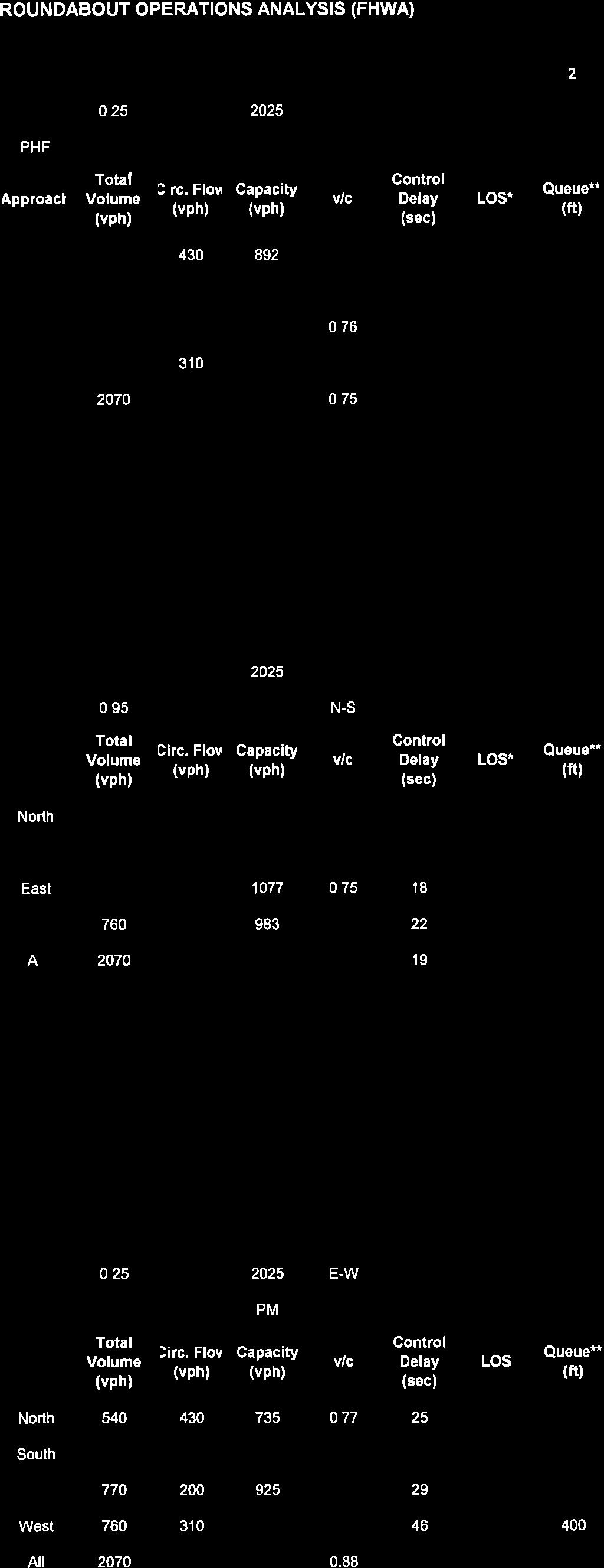
28 Clay Street Realignment Project Traffic Study Draft Report November 24, 2009 Table 8 contains the results of the comparative analysis for Alternative 2: Roundabout (with Clay Street realignment). During the PM peak hour, the westbound approach is consistently calculated as the critical approach, given 760 vehicles per hour entering the roundabout circulating with 380 vehicles per hour circulating within the roundabout. Except for NCHRP 572, all methodologies show LOS D or better conditions overall. Both SIDRA and NCHRP 572 show the worst approach to have LOS F conditions. SIDRA and NCHRP 572 also report an intersection volume-to-capacity (V/C) ratio greater than 0.85 and a worst approach V/C ratio over 1.0. FHWA guidance suggests that roundabouts should be designed to accommodate a V/C ratio at or below In order to mitigate the condition, an additional westbound through lane would be required through the roundabout intersection. The mitigation is not feasible or practical given the right of way constraints and the two lane roadway configuration of Main Street. TABLE 8 ANALYSIS METHOD COMPARISON ALTERNATIVE 2: ROUNDABOUT Methodology Peak Hour Overall Delay 1 / LOS Worst Approach Delay 1 / LOS SimTraffic SIDRA FHWA HCM 2000 NCHRP 572 AM 8 / A 11 / B (WB) PM 14 / B 18 / C (WB) AM 12 / B 20 / C (WB) PM 32 / D 53 / F (WB) AM 9 / A 11 / B (WB) PM 17 / C 22 / C (WB) AM 14 / B 16 / C (WB) PM 22 / C 28 / D (WB) AM 19 / C 26 / D (WB) PM 45 / E 65 / F (WB) Notes: LOS = Level of service WB = Westbound Bold and underline font indicate LOS F conditions. 1. Delay and level of service based on average delay (seconds per vehicle) Source: Fehr & Peers, 2007 BICYCLE, PEDESTRIAN, AND TRANSIT IMPACTS All build alternatives (Alternatives 1, 2 and 4) propose to improve bicycle and pedestrian facilities in the project area by providing raised sidewalks along Clay Street. Class II bike lanes are proposed along Clay Street north of the roundabout intersection by removing existing on-street parking. All build alternatives improve access to the Class I El Dorado Trail north of Hangtown Creek. The roundabout alternatives (Alternatives 1 and 2) decrease pedestrian exposure to conflicting traffic through the introduction of splitter islands, which provide a refuge area so that pedestrians cross only one lane of traffic at a 23
29 Clay Street Realignment Project Traffic Study Draft Report November 24, 2009 time. Through movement vehicle speeds are inherently slower at roundabout intersections compared to signalized intersections, which would also increase pedestrian safety. Pedestrian crossings are generally located 20 to 25 feet from the circulatory roadway at single lane roundabout locations. By design, the roundabout alternatives place pedestrian crossings where they are anticipated. However, since pedestrian crossings at roundabouts are uncontrolled, vision-impaired pedestrians have a more difficult time crossing the street when compared to traditional signalized intersections. Audible queues associated with deceleration and braking are not as obvious at roundabout intersections given continuous traffic flow. Alternative 4: Signal improves pedestrian safety by moving the existing crosswalk on Cedar Ravine Road to the intersection of Main Street, with the creation of a pork chop refuge island. Signalization also allows for controlled pedestrian crossings, which are often considered safer than uncontrolled crossings. Devices such as audible messages and push button vibration are available to assist visually impaired pedestrians with crossing at signalized intersections. Countdown displays may also reduce vehicle-pedestrian collisions, which are caused by pedestrians crossing at inappropriate times. The El Dorado County Transit Authority provides fixed-route transit service through the study area. The El Dorado County Transportation Commission began a five-year Short Range Transit Plan for Western El Dorado County, which may include changes to route alignment or frequency through the study area. Since transit operates in shared right-of-way, transit is subject to the same LOS experienced by general traffic. Roundabouts are designed to accommodate a city bus on all movements. EMERGENCY VEHICLE IMPACTS All build alternatives would be designed to accommodate the largest emergency response vehicle likely to pass through the study area. For Alternatives 1 and 2, large emergency vehicles would mount the truck apron adjacent to the central island to complete some turning movements at the roundabout. Emergency response times are not expected to be significantly reduced under any build alternative when compared to No Project conditions. Emergency response circulation may improve through the study area commensurate with the expected reduction in overall intersection delay. PARKING IMPACTS All build alternatives would affect parking supply. Currently, 73 spaces are available in the public parking lot located north of Main Street and east of Clay Street based on a parking space impact evaluation conducted by Quincy Engineering, Inc. The realignment of Clay Street (Alternatives 2 and 4) bisects the existing parking lot. These alternatives include constructing a new lot on the northwest corner of the intersection in space made available with the realignment. Alternative 2: Roundabout results in a net parking loss of approximately 16 spaces, which is the greatest of any alternative. Further analysis and design is needed to determine the exact number of spaces that can be replaced at the existing Ivy House lot location. Nearby (offsite) locations may be available for new or reconfigured parking to replace displaced parking. 24

30
31
32
33
34
35
36
37
38
39
40
41
42
43
44

45
46
47

48
49
50
51
52
53
54
55
56
57
58
59
60
61
62
63
64
65
66
67
68
69
70
71
72
73
74
75
76

77
78
79
80
81
82
83
84
85
86
87
88
89
90
91
92
93
94
95
96
97
98
99
100
101
102
103
104
105
106
107

108

109
110
Traffic Impact Study WestBranch Residential Development Davidson, NC March 2016
 Traffic Impact Study WestBranch Residential Development Davidson, NC March 216 TRAFFIC IMPACT STUDY FOR THE WestBranch Residential Development LOCATED IN DAVIDSON, NC Prepared For: Lennar Carolinas, LLC
Traffic Impact Analysis Chatham County Grocery Chatham County, NC
 Chatham County Grocery Chatham County, NC TABLE OF CONTENTS 1. INTRODUCTION... 1 1.1. Location and Study Area... 1 1.2. Proposed Land Use and Access... 2 1.3. Adjacent Land Uses... 2 1.4. Existing ways...
Traffic Impact Analysis Walton Acres at Riverwood Athletic Club Clayton, NC
 Traffic Impact Analysis Walton Acres at Riverwood Athletic Club Clayton, NC 1. TABLE OF CONTENTS INTRODUCTION...1 1.1. Site Location and Study Area...1 1.2. Proposed Land Use and Site Access...2 1.3.
Project Report. South Kirkwood Road Traffic Study. Meadows Place, TX October 9, 2015
 Meadows Place, TX October 9, 2015 Contents 1 Introduction... 1 2 Data Collection... 1 3 Existing Roadway Network... 2 4 Traffic Volume Development... 2 5 Warrant Analysis... 3 6 Traffic Control Alternative
TRANSPORTATION ANALYSIS REPORT US Route 6 Huron, Erie County, Ohio
 TRANSPORTATION ANALYSIS REPORT US Route 6 Huron, Erie County, Ohio December 12, 2012 Prepared for: The City of Huron 417 Main Huron, OH 44839 Providing Practical Experience Technical Excellence and Client
ALLEY 24 TRAFFIC STUDY
 ALLEY 24 TRAFFIC STUDY in City of Frostburg, Maryland January 2013 3566 Teays Valley Road Hurricane, WV Office: (304) 397-5508 www.denniscorporation.com Alley 24 Traffic Study January 2013 Frostburg, Maryland
Introduction Roundabouts are an increasingly popular alternative to traffic signals for intersection control in the United States. Roundabouts have a
 HIGH-CAPACITY ROUNDABOUT INTERSECTION ANALYSIS: GOING AROUND IN CIRCLES David Stanek, PE and Ronald T. Milam, AICP Abstract. Roundabouts have become increasingly popular in recent years as an innovative
Evaluation of M-99 (Broad Street) Road Diet and Intersection Operational Investigation
 Road Diet and Intersection Operational Investigation") Evaluation of M-99 (Broad Street) Road Diet and Intersection Operational Investigation City of Hillsdale, Hillsdale County, Michigan June 16, 2016 Final Report Prepared for City of Hillsdale 97 North Broad
Evaluation of M-99 (Broad Street) Road Diet and Intersection Operational Investigation City of Hillsdale, Hillsdale County, Michigan June 16, 2016 Final Report Prepared for City of Hillsdale 97 North Broad
Clay Street Bridge Replacement Project
 Clay Street Bridge Replacement Project Frequently Asked Questions (FAQs) The project is located in downtown Placerville on Clay Street between US Highway 50 and Main Street and Cedar Ravine Road. The proposed
Chapter 4 Traffic Analysis
 Chapter 4 Traffic Analysis PURPOSE The traffic analysis component of the K-68 Corridor Management Plan incorporates information on the existing transportation network, such as traffic volumes and intersection
1609 E. FRANKLIN STREET HOTEL TRAFFIC IMPACT STUDY EXECUTIVE SUMMARY
 1609 E. FRANKLIN STREET HOTEL TRAFFIC IMPACT STUDY EXECUTIVE SUMMARY Prepared for: The Town of Chapel Hill Public Works Department Traffic Engineering Division Prepared by: HNTB North Carolina, PC 343
5.3 TRAFFIC, CIRCULATION AND PARKING
 5.3 TRAFFIC, CIRCULATION AND PARKING This section is based upon the Downtown Lancaster Specific Plan Traffic Impact Analysis (April 2, 2008) and the Downtown Lancaster Specific Plan Parking Analysis (May
TRAFFIC IMPACT ANALYSIS
 TRAFFIC IMPACT ANALYSIS FOR THE CHAMPAIGN UNIT#4 SCHOOL DISTRICT PROPOSED HIGH SCHOOL (SPALDING PARK SITE) IN THE CITY OF CHAMPAIGN Final Report Champaign Urbana Urbanized Area Transportation Study 6/24/2014
List of Attachments. Location Map... Site Plan... City of Lake Elsinore Circulation Element... City of Lake Elsinore Roadway Cross-Sections...
 List of Attachments Exhibits Location Map... Site Plan... City of Lake Elsinore Circulation Element... City of Lake Elsinore Roadway Cross-Sections... Existing Lane Geometry and Traffic Controls... Existing
Los Altos Hills Town Council - June 18, 2015 Palo Alto City Council June 22, AGENDA ITEM #2.B Presentation
 Los Altos Hills Town Council - June 18, 2015 Palo Alto City Council June 22, 2015 AGENDA ITEM #2.B Presentation Previous Presentations Los Altos Hills Town Council in May 2014 and February 2015 Palo Alto
FRONT RANGE CROSSINGS TRAFFIC IMPACT STUDY
 FRONT RANGE CROSSINGS TRAFFIC IMPACT STUDY Prepared for: City of Thornton And Colorado Department of Transportation Prepared by: 11 Blake Street, Suite 2 Denver, Colorado 822 Contact: Brian Bern, PE, PTOE
TABLE OF CONTENTS TABLE OF CONTENTS... I APPENDICES... III LIST OF EXHIBITS... V LIST OF TABLES... VII LIST OF ABBREVIATED TERMS...
 TABLE OF CONTENTS TABLE OF CONTENTS... I APPENDICES... III LIST OF EXHIBITS... V LIST OF TABLES... VII LIST OF ABBREVIATED TERMS... IX 1 INTRODUCTION... 1 1.1 Project Overview... 1 1.2 Analysis Scenarios...
THIS PAGE LEFT BLANK INTENTIONALLY
 GA SR 25 Spur at Canal Road Transportation Impact Analysis PREPARED FOR GLYNN COUNTY, GEORGIA 1725 Reynolds Street, Suite 300 Brunswick, Georgia 31520 PREPARED BY 217 Arrowhead Boulevard Suite 26 Jonesboro,
Walmart (Store # ) 60 th Street North and Marion Road Sioux Falls, South Dakota
 60 th Street North and Marion Road Sioux Falls, South Dakota") Walmart (Store #4865-00) 60 th Street North and Marion Road Sioux Falls, South Dakota Prepared for: Wal-Mart Stores, Inc. Bentonville, Arkansas Prepared by: Kimley-Horn and Associates, Inc. ã2013 Kimley-Horn
Walmart (Store #4865-00) 60 th Street North and Marion Road Sioux Falls, South Dakota Prepared for: Wal-Mart Stores, Inc. Bentonville, Arkansas Prepared by: Kimley-Horn and Associates, Inc. ã2013 Kimley-Horn
Capital Region Council of Governments
 March 23, 2018 Capital Region Council of Governments PROJECT CONCEPT REPORT Realignment of Swamp and Northfield Road s approaches to Route 44 (Boston Turnpike) Town of Coventry SUMMARY: The Town of Coventry
DUNBOW ROAD FUNCTIONAL PLANNING
 DUNBOW ROAD FUNCTIONAL PLANNING Final Report August 3, 216 #31, 316 5th Avenue NE Calgary, AB T2A 6K4 Phone: 43.273.91 Fax: 43.273.344 wattconsultinggroup.com Dunbow Road Functional Planning Final Report
Traffic Impact Study Little Egypt Road Development Denver, North Carolina June 2017
 Traffic Impact Study Little Egypt Road Development Denver, North arolina June 2017 N. Little Egypt Road DQ\ QDQFLQJ VDOHV RU RWKHU SHUIRUPDQFH EDVHG FULWHULD Proposed Site Driveways Site Driveway 1 TRAFFI
D.13 Transportation and Traffic
 This section addresses transportation and traffic issues and impacts related to the Proposed Project. Section D.13.1 provides a description of the affected environment for the Proposed Project. Applicable
5858 N COLLEGE, LLC N College Avenue Traffic Impact Study
 5858 N COLLEGE, LLC nue Traffic Impact Study August 22, 2016 Contents Traffic Impact Study Page Preparer Qualifications... 1 Introduction... 2 Existing Roadway Conditions... 5 Existing Traffic Conditions...
NO BUILD TRAFFIC OPERATIONS
 3. 23 NO BUILD TRAFFIC OPERATIONS This section addresses the operations of the transportation system and details how it would be expected to function under year 23 No Build conditions with the projected
USA Parkway Traffic Operations Analysis, Roundabout Option. Pedro Rodriguez, NDOT; Bryan Gant, Jacobs; Randy Travis, NDOT
 Technical Memorandum TO: Hoang Hong, NDOT DATE: September 21, 2012 FROM: SUBJECT: COPIES: John Karachepone, Jacobs USA Parkway Traffic Operations Analysis, Pedro Rodriguez, NDOT; Bryan Gant, Jacobs; Randy
Abrams Associates. Transportation Impact Analysis. City of Rocklin. Prepared for: David Mohlenbrok City of Rocklin 4081 Alvis Court Rocklin, CA 95677
 Transportation Impact Analysis Sierra College Boulevard Commercial Project City of Rocklin Prepared for: David Mohlenbrok City of Rocklin 081 Alvis Court Rocklin, CA 95677 Prepared by: 1875 Olympic Boulevard,
Transportation Impact Study for Abington Terrace
 Transportation Impact Study for Abington Terrace Abington Township, Montgomery County, PA Sandy A. Koza, P.E., PTOE PA PE License Number PE059911 Prepared by McMahon Associates, Inc. 425 Commerce Drive,
Magnolia Place. Traffic Impact Analysis. Prepared for: City of San Mateo. Prepared by: Hexagon Transportation Consultants, Inc.
 Magnolia Place Traffic Impact Analysis Prepared for: City of San Mateo Prepared by: Hexagon Transportation Consultants, Inc. Updated January 4, 2010 Table of Contents 1. Introduction...1 2. Existing Conditions...6
Technical Memorandum TRAFFIC IMPACT STUDY. RIDLEY ROAD CONVENIENCE STORE Southampton County, VA. Prepared for: Mr. David Williams.
 Technical Memorandum TRFFIC IMPCT STUDY RIDLEY ROD CONVENIENCE STORE Southampton County, V Prepared for: Mr. David Williams By: Charles Smith, P.E., PTOE EPR Charlottesville, V July 2014 1 TBLE OF CONTENTS
Figure 1: East West Connector Alignment Alternatives Concept Drawing
 Page 2 of 9 Figure 1: East West Connector Alignment Alternatives Concept Drawing The Montebello Drive extension will run north south and connect Wilsonville Road to the Boones Ferry Road to Brown Road
133 rd Street and 132 nd /Hemlock Street 132 nd Street and Foster Street MINI ROUNDABOUTS. Overland Park, Kansas
 133 rd Street and 132 nd /Hemlock Street 132 nd Street and Foster Street MINI ROUNDABOUTS Overland Park, Kansas September 1, 2017 TABLE OF CONTENTS 1. INTRODUCTION... 1 2. LITERATURE REVIEW... 1 3. CONCEPT
TECHNICAL MEMORANDUM
 TECHNICAL MEMORANDUM DATE: January 17, 2005 TO: Ted Idlof, URS FROM: Jeff Clark, Fehr & Peers RE: U.S. 50 Interchange Planning Study 1042-2011 This memorandum describes conceptual improvements for the
Caltrans Sloat Boulevard Pedestrian Safety Project Response to Community Questions, Comments & Concerns
 Caltrans Sloat Boulevard Pedestrian Safety Project Response to Community Questions, Comments & Concerns Revised: May 10, 2016 The California Department of Transportation (Caltrans) is planning various
3.9 - Transportation and Traffic
 Transportation and Traffic 3.9 - Transportation and Traffic This section describes the potential transportation and traffic effects of project implementation on the project site and its surrounding area.
INDUSTRIAL BUILDING 3009 HAWTHORNE ROAD CITY OF OTTAWA TRANSPORTATION OVERVIEW REVISED. Prepared for: Canada Inc.
 INDUSTRIAL BUILDING 3009 HAWTHORNE ROAD CITY OF OTTAWA TRANSPORTATION OVERVIEW REVISED Prepared for: 7849648 Canada Inc. Octiober 1, 2015 114-598 Overview_2.doc D. J. Halpenny & Associates Ltd. Consulting
TRAFFIC STUDY GUIDELINES Clarksville Street Department
 TRAFFIC STUDY GUIDELINES Clarksville Street Department 9/1/2009 Introduction Traffic studies are used to help the city determine potential impacts to the operation of the surrounding roadway network. Two
TRAFFIC IMPACT STUDY COMPREHENSIVE UPDATE TOWN OF THOMPSON S STATION, TENNESSEE PREPARED FOR: THE TOWN OF THOMPSON S STATION
 TRAFFIC IMPACT STUDY COMPREHENSIVE UPDATE TOWN OF THOMPSON S STATION, TENNESSEE PREPARED FOR: THE TOWN OF THOMPSON S STATION Transportation Consultants, LLC 1101 17 TH AVENUE SOUTH NASHVILLE, TN 37212
Truck Climbing Lane Traffic Justification Report
 ROUTE 7 (HARRY BYRD HIGHWAY) WESTBOUND FROM WEST MARKET STREET TO ROUTE 9 (CHARLES TOWN PIKE) Truck Climbing Lane Traffic Justification Report Project No. 6007-053-133, P 101 Ι UPC No. 58599 Prepared by:
Washington St. Corridor Study
 FIGURE 7.17 Bridge Alternatives - Cross Sections 86 Discarded Alternative: Short-Term Bridge Repair Short-term repairs and west bridge span replacement were considered during analysis. Short-term repairs
Overview. Existing Conditions. Corridor Description. Assessment
 Overview A study of the 23 rd Street corridor was undertaken to document the existing conditions, analyze traffic operations, and recommend remedies for deficient situations Although 23 rd Street is frequently
Roundabout Design 101: Roundabout Capacity Issues
 Design 101: Capacity Issues Part 2 March 7, 2012 Presentation Outline Part 2 Geometry and Capacity Choosing a Capacity Analysis Method Modeling differences Capacity Delay Limitations Variation / Uncertainty
MoPac South: Impact on Cesar Chavez Street and the Downtown Network
 MoPac South: Impact on Cesar Chavez Street and the Downtown Network Prepared by: The University of Texas at Austin Center for Transportation Research Prepared for: Central Texas Regional Mobility Authority
TRAFFIC IMPACT STUDY And A TRAFFIC SIGNAL WARRANT ANALYSIS FOR A SENIOR LIVING AND APARTMENT DEVELOPMENT
 TRAFFIC IMPACT STUDY And A TRAFFIC SIGNAL WARRANT ANALYSIS FOR A SENIOR LIVING AND APARTMENT DEVELOPMENT DEERFIELD TOWNSHIP, WARREN COUNTY, OHIO Nantucket Circle and Montgomery Road () Prepared for: ODLE
Bridge Street Corridor Study Report
 Bridge Street Corridor Study Report Prepared for: Prepared by: BRIDGE STREET CORRIDOR STUDY REPORT PREPARED FOR: CITY OF ARROYO GRANDE COMMUNITY DEVELOPMENT DEPARTMENT 300 EAST BRANCH STREET ARROYO GRANDE,
Highway 111 Corridor Study
 Highway 111 Corridor Study June, 2009 LINCOLN CO. HWY 111 CORRIDOR STUDY Draft Study Tea, South Dakota Prepared for City of Tea Sioux Falls Metropolitan Planning Organization Prepared by HDR Engineering,
6060 North Central Expressway Mixed-Use Site Dallas, Texas
 Volume 1 Traffic Impact Analysis 6060 North Central Expressway Mixed-Use Site Dallas, Texas April 30, 2018 Kimley-Horn and Associates, Inc. Dallas, Texas Project #063238300 Registered Firm F-928 Traffic
TECHNICAL MEMORANDUM VDOT Central Region On Call Task Order
 Kittelson & Associates, Inc. T R A N S P O R T A T I O N E N G I N E E R I N G / P L A N N I N G 1850 Centennial Park Drive, Suite 130, 20191 P 703-885-8970 F 703-885-8971 TECHNICAL MEMORANDUM VDOT Central
CITY OF OAKLAND. 27th Street Bikeway Feasibility and Design. Final Report (v3) March 23, Kimley-Horn and Associates, Inc.
 March 23, Kimley-Horn and Associates, Inc.") CITY OF OAKLAND 27th Street Bikeway Feasibility and Design Final Report (v3) March 23, 2007 PREPARED BY: Kimley-Horn and Associates, Inc. Table of Contents 1. Introduction 3 2. 27 th Street/Bay Place Corridor
CITY OF OAKLAND 27th Street Bikeway Feasibility and Design Final Report (v3) March 23, 2007 PREPARED BY: Kimley-Horn and Associates, Inc. Table of Contents 1. Introduction 3 2. 27 th Street/Bay Place Corridor
Henderson Avenue Mixed-Use Development
 Zoning Case: Z145-3 Traffic Impact Analysis Henderson Avenue Mixed-Use Development Dallas, TX October 26 th, 216 Kimley-Horn and Associates, Inc. Dallas, Texas Project #644827 Registered Firm F-928 Traffic
EXECUTIVE SUMMARY. Page 1 of 6
 EXECUTIVE SUMMARY The purpose of this report is to identify conformance with the original traffic impact study for the proposed retail development on Lot 5 of Riverdale Retail Filing No. 1 located on the
Design Traffic Technical Memorandum
 State Road 7 Extension PD&E Study Design Traffic Technical Memorandum Palm Beach County, FL October 2010 State Road 7 Extension PD&E Study Design Traffic Technical Memorandum Palm Beach County, FL Prepared
Intersection Traffic Control Feasibility Study
 Intersection Traffic Control Feasibility Study CSAH 9 at CSAH 60 (185th Avenue) Prepared For: Dakota County Transportation Department Western Service Center 14955 Galaxie Avenue, 3rd Floor Apple Valley,
Traffic Analysis and Design Report. NW Bethany Boulevard. NW Bronson Road to NW West Union Road. Washington County, Oregon
 Traffic Analysis and Design Report NW Bethany Boulevard NW Bronson Road to NW West Union Road Washington County, Oregon May 2011 Table of Contents Table of Contents Section 1 Executive Summary... 2 Section
Route 28 (South Orleans Road)/Route 39 (Harwich Road)/Quanset Road Intersection
/Route 39 (Harwich Road)/Quanset Road Intersection") TRAFFIC FEASIBILITY STUDY Route 28 (South Orleans Road)/Route 39 (Harwich Road)/Quanset Road Intersection Orleans, Massachusetts Prepared for: Town of Orleans Prepared by: Fay, Spofford & Thorndike, LLC
TRAFFIC FEASIBILITY STUDY Route 28 (South Orleans Road)/Route 39 (Harwich Road)/Quanset Road Intersection Orleans, Massachusetts Prepared for: Town of Orleans Prepared by: Fay, Spofford & Thorndike, LLC
M-58 HIGHWAY ACCESS MANAGEMENT STUDY Mullen Road to Bel-Ray Boulevard. Prepared for CITY OF BELTON. May 2016
 M-58 HIGHWAY ACCESS MANAGEMENT STUDY Prepared for CITY OF BELTON By May 2016 Introduction Missouri State Highway 58 (M-58 Highway) is a major commercial corridor in the City of Belton. As development has
4. ENVIRONMENTAL IMPACT ANALYSIS 9. TRANSPORTATION AND TRAFFIC
 4. ENVIRONMENTAL IMPACT ANALYSIS 9. TRANSPORTATION AND TRAFFIC 4.9.1 INTRODUCTION The following section addresses the Proposed Project s impact on transportation and traffic based on the Traffic Study
DRAFT. Corridor study. Honeysuckle Road. October Prepared for the City of Dothan, AL. Prepared by Gresham, Smith and Partners
 DRAFT Corridor study Honeysuckle Road October 2017 Prepared for the City of Dothan, AL Prepared by TABLE OF CONTENTS SECTION I... 1 STUDY SUMMARY... 1 INTRODUCTION... 1 CONCLUSIONS... 5 SECTION II... 7
TRAFFIC ASSESSMENT River Edge Colorado
 TRAFFIC ASSESSMENT River Edge Colorado Submitted by: Fehr & Peers 621 17th Street, Ste. 231 Denver, CO 8293 (33) 296-43 December, 21 App. M-2 Traffic Assessment River Edge Colorado December 21 TABLE OF
Traffic Circulation Study for Neighborhood Southwest of Mockingbird Lane and Airline Road, Highland Park, Texas
 ARIZONA TEXAS NEW MEXICO OKLAHOMA February 13, 2015 Mr. Meran Dadgostar P.E., R.S. Town of Highland Park 4700 Drexel Dr. Highland Park, Texas 75205 Re: Traffic Circulation Study for Neighborhood Southwest
Complete Street Analysis of a Road Diet: Orange Grove Boulevard, Pasadena, CA
 Complete Street Analysis of a Road Diet: Orange Grove Boulevard, Pasadena, CA Aaron Elias, Bill Cisco Abstract As part of evaluating the feasibility of a road diet on Orange Grove Boulevard in Pasadena,
Harrah s Station Square Casino
 Transportation Analysis Harrah s Station Square Casino Pittsburgh, Pennsylvania Submitted To: City of Pittsburgh and Pennsylvania Gaming Control Board Prepared By: DKS Associates GAI Consultants December
4.12 TRANSPORTATION Executive Summary. Setting
 4.12 TRANSPORTATION 4.12.1 Executive Summary This section is based on the Multimodal Transportation Impact Study (TIS; 2016) prepared by Omni-Means, Ltd. to evaluate projected transportation impact conditions
Date: September 7, Project #: Re: Spaulding Youth Center Northfield, NH Property. Traffic Impact Study
 To: Ms. Susan C. Ryan Spaulding Youth Center 72 Spaulding Road Northfield, NH 03276 Date: September 7, 2017 Project #: 52455.00 From: Robin Bousa Director of Transportation Systems Re: Spaulding Youth
4.0 TRANSPORTATION SYSTEMS
 Transportation Systems 4.0 TRANSPORTATION SYSTEMS This chapter examines the impacts of the Central Corridor Extension on existing roadways and traffic operations and discusses the transit service, operations,
Traffic Impact Study. Westlake Elementary School Westlake, Ohio. TMS Engineers, Inc. June 5, 2017
 TMS Engineers, Inc. Traffic Impact Study Westlake Elementary School Westlake, Ohio June 5, 2017 Prepared for: Westlake City Schools - Board of Education 27200 Hilliard Boulevard Westlake, OH 44145 TRAFFIC
Draft Report. Traffic Impact Study. Superstore, Wal-Mart, and Kent Development. Yarmouth, Nova Scotia. Prepared for
 oad & Traffic Management Road & Traffic Management R Atlantic Traffic Engineering Specialists Draft Report Traffic Impact Study Superstore, Wal-Mart, and Kent Development Yarmouth, Nova Scotia Prepared
REVIEW OF LOCAL TRAFFIC FLOW / LONG RANGE PLANNING SOLUTIONS STUDY
 ITEM Town of Atherton TRANSPORTATION COMMITTEE STAFF REPORT TO: FROM: MEMBERS OF THE COMMITTEE ROBERT OVADIA, PUBLIC WORKS DIRECTOR DATE: FEBRUARY 12, 2019 SUBJECT: REVIEW OF LOCAL TRAFFIC FLOW / LONG
METHODOLOGY. Signalized Intersection Average Control Delay (sec/veh)
") Chapter 5 Traffic Analysis 5.1 SUMMARY US /West 6 th Street assumes a unique role in the Lawrence Douglas County transportation system. This principal arterial street currently conveys commuter traffic
Chapter 5 Traffic Analysis 5.1 SUMMARY US /West 6 th Street assumes a unique role in the Lawrence Douglas County transportation system. This principal arterial street currently conveys commuter traffic
Edgemont Village Traffic and Parking Technical Report January 2014
 Edgemont Village Traffic and Parking Technical Report January 2014 In the fall of 2013, the District of North Vancouver engaged consultants to assess existing intersection and parking conditions in Edgemont
DIMARCO CANANDAIGUA PROPERTIES HOUSING PROJECT CANANDAIGUA, ONTARIO COUNTY, NEW YORK
 TRAFFIC IMPACT STUDY FOR THE DIMARCO CANANDAIGUA PROPERTIES HOUSING PROJECT CANANDAIGUA, ONTARIO COUNTY, NEW YORK MARCH 14, 2017 PREPARED FOR: 1950 Brighton Henrietta Town Line Rd Rochester, NY 14623 PREPARED
Simulation Analysis of Intersection Treatments for Cycle Tracks
 Abstract Simulation Analysis of Intersection Treatments for Cycle Tracks The increased use of cycle tracks also known as protected bike lanes has led to investigations of how to accommodate them at intersections.
#!! "$% ##! &! # '#! % $ #!
 Executive Summary US Highway 16 (US 16) is the primary corridor connecting Rapid City to the Black Hills region. It serves a growing population of commercial and residential traffic, as well as seasonal
MEMORANDUM. DATE March 1, 2012 TO Town of Milton Mark Abbott, Seth Asante, and Efi Pagitsas Boston Region MPO Staff
 MEMORANDUM DATE March 1, 212 TO Town of Milton FROM RE Mark Abbott, Seth Asante, and Efi Pagitsas Boston Region MPO Staff FFY 211 Safety and Operations Analyses at Selected Boston Region MPO Intersections:
PINESTONE TRAFFIC IMPACT STUDY Travelers Rest, South Carolina
 PINESTONE TRAFFIC IMPACT STUDY Travelers Rest, South Carolina Prepared for Longbranch Development Prepared by January 13, 219 ii Table of Contents Subject Page Signature Page... i Table of Contents...
Access Location, Spacing, Turn Lanes, and Medians
 Design Manual Chapter 5 - Roadway Design 5L - Access Management 5L-3 Access Location, Spacing, Turn Lanes, and Medians This section addresses access location, spacing, turn lane and median needs, including
5.0 Roadway System Plan
 Southwest Boise Transportation Study Page 16 5.0 Roadway System Plan The Roadway System Plan outlines roadway improvements in the Initial Study Area. It forecasts future deficiencies on the arterial system,
Queensgate Drive Corridor Traffic Study
 January 2015 Prepared for: City of Richland Prepared by: J-U-B ENGINEERS, Inc. 2810 W. Clearwater Avenue, Suite 201 Kennewick, Washington 99336 Table of Contents Introduction and Background... 1 Existing
Shockoe Bottom Preliminary Traffic and Parking Analysis
 Shockoe Bottom Preliminary Traffic and Parking Analysis Richmond, Virginia August 14, 2013 Prepared For City of Richmond Department of Public Works Prepared By 1001 Boulders Pkwy Suite 300, Richmond, VA
CarMax Auto Superstore/ Reconditioning Center #6002 Murrieta, California
 CarMax Auto Superstore/ Reconditioning Center #6002 Murrieta, California TUSTIN 17782 17th Street Suite 200 Tustin, CA 92780-1947 714.665.4500 Fax: 714.665.4501 LOS ANGELES 145 S. Spring Street Suite 120
Delaware Avenue Corridor Study
 Delaware Avenue Corridor Study City of Marysville, Ohio February 19, 2009 ms consultants, inc. engineers, architects, planners 2221 Schrock Road Columbus, Ohio 43229-1547 ms ms consultants, inc. engineers
Road Conversion Study Plumas Street
 Plumas Street Phase I Submitted to The Regional Transportation Commission of Washoe County Submitted by Zong Tian, Ph.D., P.E. Saeedeh Farivar Haiyuan Li, Ph.D. Center for Advanced Transportation Education
Planning Committee STAFF REPORT March 7, 2018 Page 2 of 4 The following MTSOs are being used across the five subregions: Intersection Level of Service
 Planning Committee STAFF REPORT Meeting Date: March 7, 2018 Subject Summary of Issues Recommendations Financial Implications Options Attachments Changes from Committee Review Draft 2017 Multimodal Transportation
Traffic Impact Analysis
 Traffic Impact Analysis Isle of Capri Casinos, Inc. Waterloo, Iowa SEH No. A-CLAAS0501.00 November 16, 2004 Table of Contents (Continued) Table of Contents Certification Page Table of Contents Page 1.0
Traffic Study of Fuller Street, Cady Street, West Street and West Avenue. Final Report
 Traffic Study of Fuller Street, Cady Street, West Street and West Avenue Final Report July 2005 Prepared for: Town of Ludlow Prepared by: Pioneer Valley Planning Commission 26 Central Street West Springfield,
INDUSTRIAL BUILDING 1660 COMSTOCK ROAD CITY OF OTTAWA TRANSPORTATION OVERVIEW. Prepared for:
 INDUSTRIAL BUILDING 1660 COMSTOCK ROAD CITY OF OTTAWA TRANSPORTATION OVERVIEW Prepared for: Simluc Contractors Limited 2550 Blackwell Street, Ottawa K1B 5R1 October 18, 2013 113-584 Overview_1.doc D. J.
Subject: Solberg Avenue / I-229 Grade Separation: Traffic Analysis
 MEMORANDUM Transportation Bill Troe, AICP Jason Carbee, AICP 12120 Shamrock Plaza Suite 300 Omaha, NE 68154 (402) 334-8181 (402) 334-1984 (Fax) To: Project File Date: Subject: Solberg Avenue / I-229 Grade
A plan for improved motor vehicle access on Railroad Avenue in Provincetown
 A plan for improved motor vehicle access on Railroad Avenue in Provincetown February 2011 A plan for improved motor vehicle access on Railroad Avenue in Provincetown INTRODUCTION AND PROBLEM IDENTIFICATION
Troutbeck Farm Development
 Troutbeck Farm Development Willistown Township, Chester County PA For Submission To: Willistown Township Last Revised: October, 4 TPD# INLM.A. 5 E. High Street Suite 65 Pottstown, PA 9464 6.36.3 TPD@TrafficPD.com
J Street and Folsom Boulevard Lane Conversion Project (T ) Before and After Traffic Evaluation
 Before and After Traffic Evaluation") J Street and Folsom Boulevard Lane Conversion Project (T15125400) Before and After Traffic Evaluation Prepared by Transportation Division June 2014 Executive Summary On February 12, 2013, the City of Sacramento
J Street and Folsom Boulevard Lane Conversion Project (T15125400) Before and After Traffic Evaluation Prepared by Transportation Division June 2014 Executive Summary On February 12, 2013, the City of Sacramento
3.0 PROJECT DESCRIPTION
 The following section of the Draft EIR contains a description of the proposed Elk Grove Boulevard/SR 99 Interchange Modification project, consistent with the requirements of CEQA Guidelines Section 15124.
MEMORANDUM. Charlotte Fleetwood, Transportation Planner
 MEMORANDUM Date: Updated August 22, 2017 To: Organization: Charlotte Fleetwood, Transportation Planner Boston Transportation Department From: Jason DeGray, P.E., PTOE, Regional Director of Engineering
MEMORANDUM. To: 1.0 PURPOSE
 MEMORANDUM To: Scott Holland, Elements Architecture From: Brian Grover, Dudek Date: July 16, 2014 1.0 PURPOSE In response to the November 4, 2013 request (RE: Incomplete Application Southern California
 TRAFFIC IMPACT STUDY CANYON HILLS PROJECT LOS ANGELES, CALIFORNIA INTRODUCTION This traffic analysis has been conducted to identify and evaluate the potential traffic impacts of the proposed Canyon Hills
ENHANCED PARKWAY STUDY: PHASE 2 CONTINUOUS FLOW INTERSECTIONS. Final Report
 Preparedby: ENHANCED PARKWAY STUDY: PHASE 2 CONTINUOUS FLOW INTERSECTIONS Final Report Prepared for Maricopa County Department of Transportation Prepared by TABLE OF CONTENTS Page EXECUTIVE SUMMARY ES-1
OFFICE/RETAIL DEVELOPMENT 1625 BANK STREET OTTAWA, ONTARIO TRANSPORTATION BRIEF. Prepared for: Canada Inc.
 OFFICE/RETAIL DEVELOPMENT 1625 BANK STREET OTTAWA, ONTARIO TRANSPORTATION BRIEF Prepared for: 9402209 Canada Inc. December 15, 2015 115-625 Report_2.doc D. J. Halpenny & Associates Ltd. Consulting Transportation
Traffic Impact Study for Rolling Ridge Redevelopment
 Traffic Impact Study for Rolling Ridge Redevelopment Webster Groves, Missouri October 19, 2018 Prepared For: Gershman Commercial Real Estate 150 North Meramec Avenue Suite 500 St. Louis, Missouri 63105
4.10 TRAFFIC AND CIRCULATION
 4.10 TRAFFIC AND CIRCULATION The following section is based on a traffic and circulation study prepared by Fehr & Peers, Inc. (November 2003; refer to Appendix F for technical calculations). The effects
CITY OF OTTAWA ROADWAY MODIFICATION APPROVAL UNDER DELEGATED AUTHORITY
 RMA-2015-ATM-038 CITY OF OTTAWA ROADWAY MODIFICATION APPROVAL UNDER DELEGATED AUTHORITY DATE: April 22, 2015 SUBJECT Approval of Roadway Modifications Recommended through an Area Traffic Management Study
Draft North Industrial Area-Wide Traffic Plan
 Summary of North Industrial and Hudson Bay Industrial Recommended Improvements Table 1. Summary of s Item Location 1 2 3 4 5 6 7 8 9 10 11 12 Millar Ave north of 51st St Super 8 Motel back lane 400 Block