Prepared For: Shieldbay Developments Inc. c/o Matson, McConnell Ltd. 2430A Bloor Street West Toronto, Ontario M6S 1P9.
|
|
|
- Chad Cunningham
- 5 years ago
- Views:
Transcription
1 Prepared For: Shieldbay Developments Inc. c/o Matson, McConnell Ltd. 2430A Bloor Street West Toronto, Ontario M6S 1P9 Prepared By: URS Canada Inc. 4 th Floor, 30 Leek Crescent Richmond Hill, Ontario L4B 4N T0200

2 November 29, 2013 Our Ref.: T0200 Shieldbay Developments Inc. c/o Matson McConnell Ltd. 2430A Bloor Street West Toronto, Ontario M6S 1P9 Attention: Mr. Chris Matson Dear Mr. Matson: Re: Transit Facilities Plan Draft Plan of Subdivision Shieldbay Developments Inc. Northeast Quadrant of Dundas Street and Postridge Drive Town of Oakville, Regional Municipality of Halton URS Canada Inc. is pleased to submit our report for the above noted Transit Facilities Plan in support of Draft Plan of Subdivision application. This report documents the transit requirements for the proposed Shieldbay development situated on the parcel of land on the northeast quadrant of the Dundas Street and Postridge Drive intersection in the Town of Oakville. Should you have any questions regarding the study, please feel free to contact either of the undersigned at Yours very truly, URS CANADA INC. Kevin I. Phillips, P.Eng., AVS Head, Municipal Transportation Tia Nguyen, P. Eng. Transportation Engineer 2
3 Prepared For: Shieldbay Developments Inc. c/o Matson, McConnell Ltd. 2430A Bloor Street West Toronto, Ontario M6S 1P9 Prepared By: URS Canada Inc. 4 th Floor, 30 Leek Crescent Richmond Hill, Ontario L4B 4N T0200
4 TABLE OF CONTENTS 1.0 Introduction Development Plan Development Context Road Network Configuration Transit Facilities Existing Transit Facilities Planned Transit Facilities Pedestrian and Cycling Connections to Transit Routes Transit Facilities Design Criteria and Plan Transit Corridor Cross-section Design Transit Stops Transit Stop Locations Conclusions and Recommendations LIST OF TABLES Table 4-1: Transit Corridors Proposed Design Criteria... 9 LIST OF FIGURES Figure 1-1: Development Concept Plan and Site Location... 2 Figure 1-2: Development Draft Plan of Subdivision... 4 Figure 3-1: Oakville Transit Routes... 6 Figure 3-2: GO Transit Routes... 6 Figure 4-1: Draft North Oakville East Trails Plan... 8 Ref #: T0200 i
5 1.0 INTRODUCTION URS Canada Inc. was retained by Shiedlbay Developments Inc. to prepare a Transit Facilities Plan in support of a Draft Plan of Subdivision application. The proposed Shieldbay development is located in the northeast quadrant of the Dundas Street East and Postridge Drive intersection in the Town of Oakville. The lands are proposed primarily for residential uses with a mix of urban core and institutional land uses. The location of these lands is illustrated in Figure 1-1. Figure 1-1: Development Concept Plan and Site Location Note: Not to scale 2
6 2.0 DEVELOPMENT PLAN 2.1 Development Context The Draft Plan of Subdivision for Shieldbay development is illustrated in Figure 1-2. The proposed development is one of the blocks to be developed in the surrounding area (named the North Oakville East Secondary Plan by the Town of Oakville) bounded by 407 ETR to the north, Dundas Street to the south, Sixteen Mile Creek to the west and Ninth Line to the east. The ultimate North Oakville community is targeted to have a future population of 55,000 and employment of 35,000. The Town s planning approach in North Oakville is to develop a Transit-First community. The planning related attributes within the North Oakville lands that promote non-auto travel include consolidated mixed-use development in compact urban form, transit supportive land use densities, a pedestrian/cyclist friendly grid base street system, as well as effective parking management strategies within the community. Within the North Oakville Secondary Plan Area, the Sheildbay lands are generally bounded by Natural Heritage System lands to the north, Dundas Street to the south, 8 th Line to the east, and Postridge Drive to the west. Generally, in the vicinity of the study area, the lands are primarily residential uses, with Dundas Urban Core uses adjacent to Dundas Street, and Trafalgar Urban Core uses on adjacent lots to the west. It is proposed to develop a total of 520 low and medium density residential dwelling units on the subject lands (343 single family homes, 84 semi-detached homes, and 93 townhomes). Lands at the southern limits are designated part of the Dundas Street Urban Core Area for mixed uses (potential for a mix of residential and commercial uses, and/or office uses) with a total area of ha. Also, there is a significant amount of lands located within the Town s Natural Heritage System (NHS) at the north limits. A school is also proposed with a total area of ha. to accommodate future residents. 2.2 Road Network Configuration Within the study area, three external access points are provided along Dundas Street and include: Dundas Street / Postridge Drive (signalized); Dundas Street / Eighth Line (signalized); and Dundas Street / Street D (unsignalized). Additionally, access to Trafalgar Road is available once the Dundas Trafalgar Inc. lands (to the west of Postridge Drive) are developed with connections via Street B and Street C (refer to Figure 1-2). 3
7 Figure 1-2: Development Draft Plan of Subdivision Note: Not to scale 4
8 3.0 TRANSIT FACILITIES The development and configuration of the road network within the North Oakville lands is intended to be supportive of alternative travel modes, including transit. Local transit routes within the North Oakville lands are concentrated along the key east-west and north-south corridors. The transit routing is complimented with a comprehensive network of sidewalks and bicycle connections throughout the community, to facilitate walking and cycling to transit stops. This includes sidewalks on both sides of all streets and multi-use path or trail connections to link adjacent sidewalks. Based on the Transportation Plan in the Town of Oakville s Secondary Plan Transit Plan (August 2009), the proposed transit corridors within the study area are illustrated in Figure A1 of Appendix A and include: Trafalgar Road It is a designated Major Arterial road, which provides Primary Transit Corridor Service. Trafalgar Road will be widened to six lanes with provisions for designated Bus Rapid Transit (BRT) lanes in the near future; Dundas Street It is a designated Major Arterial road, which provides Primary Transit Corridor Service with high frequency service. It provides connections within Oakville, as well as intermunicipal connections and connections to inter-regional network of services. Dundas Street is currently being widened to six lanes with provision for BRT lanes in the near future; Eighth Line It is designated Collector road, which provides Secondary Transit Corridor Service. Postridge Drive It is a designated Collector road, which provides Community Transit Corridor Service south of Dundas Street and proposed community service north of Dundas Street; 3.1 Existing Transit Facilities Oakville Transit In the immediate vicinity of the study area, Oakville Transit provides bus service via Route #20 (Northridge). Route #20 provides north-south transit service along Dundas Street, and loops around Postridge Drive, and North Ridge Trail. It provides headways of 30 minutes during the weekday peak hours, and 60 minutes during the weekend peak hours. The transit route connects to Oakville GO Station and Uptown Core Bus Terminal. Figure 3-1 illustrates the existing Oakville Transit Service. GO Transit GO Transit provides transit service via the following routes: Route #20 (Milton/Oakville) to/from Milton station from/to Oakville station from Monday to Friday, with a commuter carpool lot located in the northwest quadrant of the 407 ETR and Trafalgar Road interchange. During the weekday a.m. peak hours, it provides one-way service along Trafalgar Road with 60-minute headways from Milton GO Station to Oakville GO Station. During the weekday p.m. peak hours, it provides one-way service with 60-minute headways from the Oakville GO Station to the Milton GO Station. 5


9 Route #46 (407 West) provides service to/from Oakvile GO Station from/to York University with frequency of 30-minutes during the weekday peak hours. Figure 3-2 illustrates the existing GO Transit services. Figure 3-1: Oakville Transit Routes 1 Site Location Figure 3-2: GO Transit Routes 2 Site Location 1 Source: accessed September 27, Source: accessed September 27,
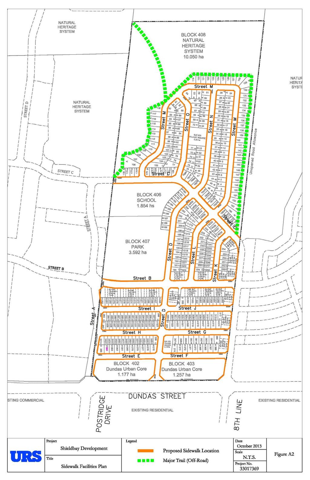
10 3.2 Planned Transit Facilities Dundas Street Bus Rapid Transit Halton Region, City of Burlington, and the Town of Oakville are currently undergoing separate studies to consider Bus Rapid Transit (BRT) through Burlington and Oakville along Dundas Street (Brant Street to Trafalgar Road) and Trafalgar Road (Cornwall Road to 407 ETR). The focus of these studies is to provide opportunities for a development of multi-modal transportation systems along the Dundas Street and Trafalgar Road corridors. The study also provides an opportunity to enhance corridors for pedestrians and cyclists. Proposed infrastructure improvements will include exclusive curb bus rapid transit lanes along Dundas Street from Brant Street to Trafalgar Road, and Trafalgar Road from Oakville GO Station to 407 ETR carpool lot. Based on the Trafalgar BRT Corridor Study, potential far-side curb BRT stations are identified along the east and west sides of Trafalgar Road at Street B within the study area. Further, based on the Dundas BRT Corridor Study, a potential BRT station is identified at the Uptown Core Bus Terminal. 3.3 Pedestrian and Cycling Connections to Transit Routes Pedestrian Facilities A comprehensive network of sidewalks and sidewalk connections is proposed to provide for convenient movement throughout the North Oakville Secondary Plan area. Sidewalk connections should also be incorporated to link sidewalks to paths and other walkways at notable sites, open space areas, as well as the Town s Natural Heritage System. The community is configured to provide pedestrian access to pedestrian and transit routes. It is desirable to provide pedestrian connections or openings to transit routes along arterial roads every 250 metres. Based on the Draft North Oakville East Trails Plan (dated October, 2012) a trail network was proposed within the North Oakville lands. The trail network will centre on the main Natural Heritage System corridor, and comprises of north-south/east-west Major Trails. Figure 4-1 illustrates the Conceptual North Oakville Trails and Cycling Network. Within the Shieldbay Development lands, a functional pedestrian sidewalk network will be provided to complement the North Oakville East Trails, and enhance pedestrian connectively and safety. Pedestrian sidewalks are generally proposed within the study area based on the following principles: Pedestrian sidewalks will be provided on both sides along Avenue/Transit Corridor and Connector/Transit Corridor roads; Pedestrian sidewalks will be provided on both sides along local residential roads; Connections between the pedestrian sidewalk network and the Town s trail system will be provided with reasonable spacing. Figure A2 of Appendix A illustrates the proposed pedestrian sidewalk network within the study area. 7


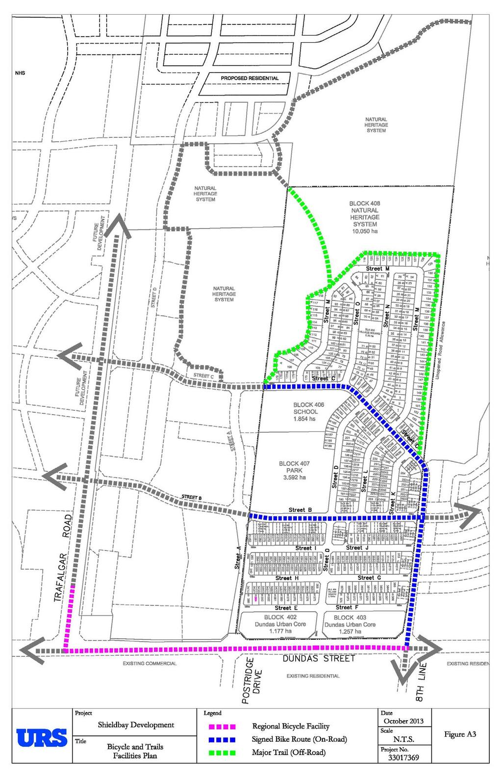
11 Figure 4-1: Draft North Oakville East Trails Plan 3 Site Location Cycling Facilities A comprehensive cycling plan for the North Oakville Secondary Plan area will improve the safety and attractiveness of cycling as an alternative travel mode. The Town of Oakville has prepared a Draft North Oakville East Trails Plan (dated October, 2012), which identifies comprehensive cycling (on- and offroad) and sidewalk networks. Based on the Draft North Oakville East Trails Plan, the conceptual bicycle network within the study area includes: Trafalgar Road It is a designated Regional Bicycle Facility; Dundas Street It is a designated Regional Bicycle Facility; The east/west and north/south Major Trail (off road) within the Natural Heritage Area; Street B It is a designated Signed Bike Route (on-road) between Postridge Drive and Eighth Line; and Street C It is a designated Signed Bike Route (on-road) between Postridge Drive and Eighth Line; Figure A3 of Appendix A illustrates the proposed bicycle plan within the study area. 3 Source: North Oakville Trails Plan East & West Study Areas, Town of Oakville, October 2012, accessed September 15,
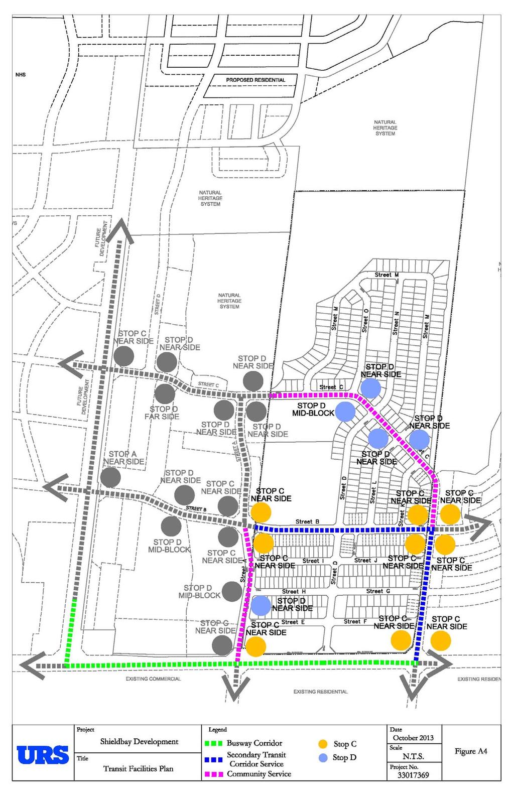
12 4.0 TRANSIT FACILITIES DESIGN CRITERIA AND PLAN 4.1 Transit Corridor Cross-section Design The design of the Major Arterial/Transit Corridors (i.e. Trafalgar Road and Dundas Street) will be identified based on the findings of the currently on-going Environmental Assessment Study (Trafalgar Road). Table 1 summarizes the proposed design criteria of the Avenue and Connector Transit Corridors within the study area based on the Town s requirements. Table 4-1: Transit Corridors Proposed Design Criteria Street B Street A & Street C Road Type: Avenue/Transit Corridor Connector/Transit Corridor Type of Urban Area: Neighbourhood Centre General Urban & Suburban Neighbourhoods Lane Pattern: 2.25 m parking 4.0 m x m parking 3.75 m 3.50 m 2.25 m parking FOC* to FOC: 12.5 m 9.50 m R.O.W.: 22.0 m 19.0 m Sidewalk: Both Sides Both Sides Cycling Facility: - Signed Bike Route * FOC - Face of Curb 4.2 Transit Stops According to the Town of Oakville s Transit Plan (August 2009) and the North Oakville Secondary Plan Transit Plan Developer s Toolkit, local transit routes provide coverage such that most residences, and all schools, neighbourhood centres and public facilities are within a walking distance of no more than 400 metres of a bus stop. Bus stops should be placed at most intersections along the routes, passenger generators, and transfer points. Bus stop spacing should be approximately metres (not less than 200 metres). It is also noted that transit stop spacing along transit routes is typically 250 metres. The following are transit stop types based on customer needs, and will be determined through warrants outlined in Oakville s Toolkit and include: Stop A - Will be a sheltered Info stop, with a bench, shelter, lighting, power pedestal and wheelchair landing pad; Stop B - Will be an Info stop with a bench, lighting, power pedestal and wheelchair landing pad; Stop C - Will be a Comfort stop with a bench and wheelchair landing pad; and Stop D - Will be a Basic stop implemented at the maximum spacing of 250 metres along a transit route. 9
13 4.3 Transit Stop Locations Based on the criteria as stated in Section 4.2 Transit Stops, as well as a review of the Draft Plan of Subdivisions, transit stops are strategically proposed within the study area. The following is a summary of the proposed transit stop locations: Street A / Dundas Street Stop C Comfort; Street A / Street H Stop D Basic; Street A / Street B Stop C Comfort; Street A / Street C Stop D Basic; Street B / Street A Stop C Comfort; Street B / Street C Stop C Comfort; Street C / 8 th Line Street C Comfort; and Street C / Street B - Street C Comfort; Figure A4 of Appendix A illustrates the proposed transit stop locations and types. It should be noted that these are preliminary locations for consideration, the stop locations and types should be reviewed when the ultimate transit routing plan is available given that some of the stops may not be required due to the potential for consolidated stops. 10
14 5.0 CONCLUSIONS AND RECOMMENDATIONS In summary, the configuration of the road network and proposed infrastructure within the Shieldbay development accommodate alternative travel modes (i.e. transit, walking, and cycling). Local transit routes provide coverage such that most residences, neighborhood centres, and public facilities will be within a reasonable walking distance of a bus stop. The proposed development is supported by transit routes complimented with a comprehensive network of sidewalks and bicycle connections throughout the community to facilitate walking and cycling to transit stops. This includes sidewalks on both sides of all streets and multi-use path or trail connections to link the adjacent sidewalks. Providing convenient street-side bicycle lockup/locker facilities throughout the Urban Core Areas will amend the safety and attractiveness of alternative travel modes. It is envisioned that higher non-auto mode splits for the North Oakville lands can be achieved as there is a comprehensive network of sidewalks and cycling facilities, transit services, Bus Rapid Transit lanes on the arterial corridors. Also, there are planning related attributes of the North Oakville lands that promote non-auto travel, such as consolidated mixed-use development in compact urban form, transit supportive land use densities, a pedestrian/cyclist friendly grid base street system, as well as effective parking management strategies within the community. 11
15 APPENDIX A Figures

16 Figure A1: North Oakville Transit Plan Source: Town of Oakville North Secondary Plan Transit Plan, Town of Oakville, August 2009
17
18
19
Sixth Line Development - Transit Facilities Plan
 Memorandum Date: November 13, 2012 To: From: c.c. Subject: Rob Freeman (Freeman Planning) Kevin Phillips Sixth Line Development - Transit Facilities Plan 33016631 This memo was prepared to review the transit
Dundas. Plan Propose. ed North Northea Town
 Dundas Trafalgar Inc. Transit Facilities Plan Propose ed North Oakville Residential Subdivision Northea ast Corner of Dundas Street and Trafalgar Road Town of Oakville 12237 December 2012 Table of Contents
VIVA RETIREMENT COMMUNITIES OAKVILLE TRAFFIC IMPACT STUDY
 VIVA RETIREMENT COMMUNITIES OAKVILLE TRAFFIC IMPACT STUDY VIVA RETIREMENT COMMUNITIES OAKVILLE TRAFFIC IMPACT STUDY DECEMBER 2012 READ, VOORHEES & ASSOCIATES TORONTO, ONTARIO Read, Voorhees & Associates
Classification Criteria
 SCHEDULE D TO RECOMMENDED OFFICIAL PLAN AMENDMENT NO. 40 SCHEDULE C-4 Road Criteria Criteria Traffic Service Objective Land Service/Access Typical Daily Traffic Volume Flow characteristics Travel Speed
Welcome. If you have any questions or comments on the project, please contact:
 Welcome This drop-in public open house is intended to provide information about the Bay Street bike lanes project. This project proposes a dedicated cycling facility along Bay Street between Aberdeen Avenue
Town of Oakville Growth Areas Transportation Report
 Growth Areas Transportation Report Oakville itrans Consulting Inc. 100 York Blvd., Suite 300 Richmond Hill, ON L4B 1J8 Tel: (905) 882-4100 Fax: (905) 882-1557 www.itransconsulting.com Growth Areas Transportation
North Oakville. Terms of Reference for Transportation Impact Studies and Transportation Functional Design Studies
 North Oakville Terms of Reference for Transportation Impact Studies and Transportation Functional Design Studies North Oakville Terms of Reference for Transportation Impact Studies and Transportation
CITY OF VAUGHAN EXTRACT FROM COUNCIL MEETING MINUTES OF OCTOBER 30, 2012
 CITY OF VAUGHAN EXTRACT FROM COUNCIL MEETING MINUTES OF OCTOBER 30, 2012 Item 31, Report No. 39, of the Committee of the Whole, which was adopted without amendment by the Council of the City of Vaughan
Chapter 7. Transportation. Transportation Road Network Plan Transit Cyclists Pedestrians Multi-Use and Equestrian Trails
 Chapter 7 Transportation Transportation Road Network Plan Transit Cyclists Pedestrians Multi-Use and Equestrian Trails 7.1 TRANSPORTATION BACKGROUND The District of Maple Ridge faces a number of unique
TRANSPORTATION NEEDS ASSESSMENT
 TRANSPORTATION NEEDS ASSESSMENT A travel demand analysis was carried out to determine the operational issues and the potential benefit that adding traffic capacity would have on the road network. All the
APPENDIX 5. February 2013
 APPENDIX 5 APPENDIX 5 February 2013 APPENDIX 5-A Paper #5a Transit Service and Infrastructure Paper #5a TRANSIT SERVICE AND INFRASTRUCTURE This paper outlines public transit service within the Town of
Nomination. Halton Region in Context
 Transportation Association of Canada Sustainable Urban Transportation Award Nomination of: Region of Halton Regional Transportation Master Plan Study March 2005 Nominated by: Nomination The TAC Sustainable
NEWMARKET CENTRE Mobility Hub Profile
 Mobility Hub Profile Dundas Newmarket West-Bloor Centre Anchor Hub Gateway Hub N MOBILITY HUBS: Places of connectivity between regional and rapid transit services, where different modes of transportation
DON MILLS-EGLINTON Mobility Hub Profile
 Mobility Hub Profile Dundas Don Mills-Eglinton West-Bloor Anchor Hub Gateway Hub N MOBILITY HUBS: Places of connectivity between regional and rapid transit services, where different modes of transportation
2136 And 2148 Trafalgar Road Townhouse Development Traffic Brief. Paradigm Transportation Solutions Limited
 2136 And 2148 Trafalgar Road Townhouse Development Traffic Brief Paradigm Transportation Solutions Limited March 217 March 217 Project: 1627 Diana Vlasic, M.C.I.P., R.P.P Metropolitan Consulting 445 Paletta
Transportation Master Plan Advisory Task Force
 Transportation Master Plan Advisory Task Force Network Alternatives & Phasing Strategy February 2016 BACKGROUND Table of Contents BACKGROUND Purpose & Introduction 2 Linking the TMP to Key Council Approved
APPENDIX 2 LAKESHORE ROAD TRANSPORTATION REVIEW STUDY EXECUTIVE SUMMARY
 APPENDIX 2 LAKESHORE ROAD TRANSPORTATION REVIEW STUDY EXECUTIVE SUMMARY Appendix 2 City of Mississauga Lakeshore Road FINAL REPORT Transportation Review Study December 2010 EXECUTIVE SUMMARY Study Purpose
Chapter 6 Transportation Plan
 Chapter 6 Transportation Plan Transportation Plan Introduction Chapter 6 Transportation Plan Transportation Plan Introduction This chapter describes the components of Arvada s transportation system, comprised
RZC Appendix 8A Marymoor Subarea Street Requirements
 RZC Appendix 8A Marymoor Subarea Street Requirements For additional design details for Marymoor Subarea infrastructure, refer to the 2017 Marymoor Subarea Infrastructure Planning Report. STREET REQUIREMENTS
4. ENVIRONMENTAL IMPACT ANALYSIS 9. TRANSPORTATION AND TRAFFIC
 4. ENVIRONMENTAL IMPACT ANALYSIS 9. TRANSPORTATION AND TRAFFIC 4.9.1 INTRODUCTION The following section addresses the Proposed Project s impact on transportation and traffic based on the Traffic Study
19 July 2016 OUR REF:
 19 July 2016 OUR REF: 602263-01000 194168 Ontario Ltd. 320 McRae Street Ottawa, ON K1Z 5R8 Attention: Brian Casagrande Dear Brian: Re: 320 McRae/1976 Scott Redevelopment CTS Addendum #1 This Addendum has
Markham Sports, Entertainment and Cultural Centre Transportation Overview
 Markham Sports, Entertainment and Cultural Centre Transportation Overview ARENA LOCATION 2 3 TRANSPORTATION VISION IN MARKHAM On April 12, 2011, Markham Council adopted a long-term Transportation Vision
City of Gainesville Transportation/Roadway Needs PROJECT SUMMARY
 A1 Roadway Resurfacing $23,846,000 TYPE: Preservation of existing system Roadway resurfacing A2 Signal Replacement $6,000,000 TYPE: Preservation of existing system Replace traffic signals. B1 W 6th St
CPC Parking Lot Riverside Drive. Transportation Rationale
 CPC Parking Lot Transportation Rationale Prepared By: NOVATECH Suite 200, 240 Michael Cowpland Drive Ottawa, Ontario K2M 1P6 September 2015 Novatech File: 114093 Ref: R-2015-153 Table of Contents 1.0 INTRODUCTION...
ATTACHMENT 4 - TDM Checklist. TDM Checklist Overview
 ATTACHMENT 4 - TDM Checklist TDM Checklist Overview The proposed checklist rates developments on the degree to which they are TDM and transit supportive. Points are assigned based on the level of transit
EXECUTIVE SUMMARY: TRANSIT-ORIENTED DEVELOPMENT IN SMITHS FALLS, ONTARIO; A COMPARISON BETWEEN TWO SITES
 EECUTIVE SUMMARY: TRANSIT-ORIENTED DEVELOPMENT IN SMITHS FALLS, ONTARIO; A COMPARISON BETWEEN TWO SITES Topic and Purpose In 2007, the Mayor of Ottawa s Task Force on Transportation suggested adding a
Town of Milton. Derry Green Corporate Business Park Secondary Plan. Transportation Strategy Report Final. December 2010
 Town of Milton Derry Green Corporate Business Park Secondary Plan Transportation Strategy Report Final December 2010 Excellence in Transportation Planning Town of Milton Derry Green Corporate Business
Solana Beach Comprehensive Active Transportation Strategy (CATS)
") Solana Beach Comprehensive Active Transportation Strategy (CATS) 3.0 Goals & Policies The Solana Beach CATS goals and objectives outlined below were largely drawn from the Solana Beach Circulation Element
Solana Beach Comprehensive Active Transportation Strategy (CATS) 3.0 Goals & Policies The Solana Beach CATS goals and objectives outlined below were largely drawn from the Solana Beach Circulation Element
9 Leeming Drive Redevelopment Ottawa, ON Transportation Brief. Prepared By: Stantec Consulting Ltd.
 9 Leeming Drive Redevelopment Ottawa, ON Transportation Brief Prepared By: Stantec Consulting Ltd. TIA GUIDELINES CHECKLIST Report Context Municipal Address Comment: Section 1.1 Location relative to major
City of Hamilton s Transportation Master Plan (TMP) Public Consultation 3 December 2015
 Public Consultation 3 December 2015") City of Hamilton s Transportation Master Plan (TMP) Public Consultation 3 December 2015 McPhail Transportation Planning Services Ltd. AGENDA 6:00 7:00 pm Viewing Boards / Q & A with the Team 7:00 7:50
City of Hamilton s Transportation Master Plan (TMP) Public Consultation 3 December 2015 McPhail Transportation Planning Services Ltd. AGENDA 6:00 7:00 pm Viewing Boards / Q & A with the Team 7:00 7:50
7 June 2018 OUR REF:
 7 June 2018 OUR REF: 476729-01000 Mirtillo Estates Inc. 1681 Langstaff Road, Unit 1 Vaughan, Ontario, L4K 5T3 Attention: Joran Weiner Vice-President Dear Mr. Weiner: Re: Mirtillo Estates Sales Office Transportation
Improving Cyclist Safety at the Dundas Street West and Sterling Road Intersection
 STAFF REPORT ACTION REQUIRED Improving Cyclist Safety at the Dundas Street West and Sterling Road Intersection Date: August 17, 2012 To: From: Wards: Reference Number: Public Works and Infrastructure Committee
Welcome. The Brooklin Secondary Plan and Transportation Master Plan are collectively referred to as the Brooklin Study.
 Welcome The Town of Whitby is undertaking a study to prepare a Secondary Plan and Transportation Master Plan to guide and manage growth in the Brooklin area. The Brooklin Secondary Plan and Transportation
Corporation of the Town of Oakville. December 16, 2013
 Corporation of the Town of Oakville Transportation Impact Analysis and Parking Study for Proposed Secondary School, Oakville Draft Final Report Submitted by: HDR Corporation 100 York Boulevard, Suite 300
Centennial Neighbourhoods Transportation Management Plan Summary of Phase 1 Consultation. Overview of Issues
 1 Centennial Neighbourhoods Transportation Management Plan Summary of Phase 1 Consultation The Centennial Neighbourhoods Transportation Management Plan (CNTMP) is being undertaken to support the Secondary
University of Victoria Campus Cycling Plan Terms of Reference. 1.0 Project Description
 University of Victoria Campus Cycling Plan Terms of Reference 1.0 Project Description The Campus Cycling Plan, a first for the University, will provide a comprehensive and coordinated approach to support
BUS RAPID TRANSIT. A Canadian Perspective. McCormick Rankin International. John Bonsall P.Eng
 BUS RAPID TRANSIT A Canadian Perspective Why choose BRT? Because it is a practical and cost effective rapid transit solution for the most common types of land use in urban Canada Operating experience shows
Exhibit 1 PLANNING COMMISSION AGENDA ITEM
 Exhibit 1 PLANNING COMMISSION AGENDA ITEM Project Name: Grand Junction Circulation Plan Grand Junction Complete Streets Policy Applicant: City of Grand Junction Representative: David Thornton Address:
Goodlettsville Bicycle and Pedestrian Plan Executive Summary
 Goodlettsville Bicycle and Pedestrian Plan July 2010 In Cooperation with the Nashville Area Metropolitan Planning Executive Organization Summary Introduction Progressive and forward thinking communities
Chapter 3 BUS IMPROVEMENT CONCEPTS
 Chapter 3 BUS IMPROVEMENT CONCEPTS The purpose of this chapter is to describe potential bus improvement strategies and potential impacts or implications associated with BRT implementation within the existing
West Dimond Blvd Upgrade Jodhpur Street to Sand Lake Road
 West Dimond Blvd Jodhpur St to Sand Lake CSS Transportation Project Summary Municipality of Anchorage Project # 05 005 Project Manager: John Smith, P.E. (MOA PM&E) Project Administrator: Julie Makela,
York Region Population and Employment Growth
 March 1, 2016 1 York Region Population and Employment Growth York Region needs to comply with The Provincial Growth Plan and new forecasts introduced to 2036 and 2041 2 Regional Official Plan Review York
CONNECTING PEOPLE TO PLACES
 CONNECTING PEOPLE TO PLACES 82 EAST BENCH MASTER PLAN 07 Introduction The East Bench transportation system is a collection of slow moving, treelined residential streets and major arteries that are the
5 CIRCULATION AND STREET DESIGN
 5 CIRCULATION AND STREET DESIGN This chapter describes circulation and streetscape improvements proposed for the Northwest Chico Specific Plan Area. It includes detailed design specifications for existing
Moving Cambridge. City of Cambridge Transportation Master Plan Public Consultation Centre. March 7, :00 8:00 PM.
 City of Cambridge Transportation Master Plan Public Consultation Centre March 7, 2018 5:00 8:00 PM Region of Waterloo City of Cambridge Transportation Master Plan Public Consultation Centre March 7, 2018
City of Waterloo Complete Streets Policy
 City of Waterloo Complete Streets Policy Chris Hodgson P. Eng City of Waterloo Complete Streets Forum 2011 April 28-29 Toronto Waterloo context: Current population Major employers Universities and student
Anniedale- Tynehead NCP Best Practices in Transportation Planning Summary
 Anniedale- Tynehead NCP Best Practices in Transportation Planning Summary The City of Surrey Anniedale-Tynehead NCP Best Practices Transportation Summary This document provides a summary of the Bunt &
WELCOME TO OPEN HOUSE # 1 June 14, 2017
 Langstaff Road Weston Road to Highway 7 Class Environmental Assessment Study WELCOME TO OPEN HOUSE # 1 June 14, 2017 Please sign in and join our mailing list Purpose of Open House #1 & Study Area York
Appendix C. NORTH METRO STATION AREA TRAFFIC IMPACT STATEMENT 88th Avenue Station
 Appendix C NORTH METRO STATION AREA TRAFFIC IMPACT STATEMENT 88th Avenue Station Prepared for: Regional Transportation Department and URS Corporation as part of the North Metro EIS David Evans and Associates,
Chapter 5 Future Transportation
 Chapter 5 Future Transportation The Future Land Use Plan identifies the desired land use designations. The land uses desired for Crozet depend, in large part, on the success of the transportation system,
Chapter 3 DESIGN SPECIFICATIONS
 Brampton PathWays Planning and Design Guidelines 27 Chapter 3 DESIGN SPECIFICATIONS 3.1 CLASS 1 MULTI-USE PATH Off-road multi-use trails are the backbone of the Brampton PathWays Network. They are typically
AIRPORT ROAD ENVIRONMENTAL ASSESSMENT
 WELCOME TO PUBLIC INFORMATION CENTRE #1 AIRPORT ROAD ENVIRONMENTAL ASSESSMENT From Braydon Boulevard/Stonecrest Drive to Countryside Drive November 23, 2017 6:30 PM 8:30 PM Please sign in and fill out
Dundas Street (Regional Road 5) Corridor Improvements Class EA. Welcome to Public Information Centre #3. Thursday, September 13, 2012
 Corridor Improvements Class EA. Welcome to Public Information Centre #3. Thursday, September 13, 2012") Dundas Street (Regional Road 5) Corridor Improvements Class EA Welcome to Public Information Centre #3 Thursday, September 13, 2012 Members of the Project Team are available to discuss the information
Dundas Street (Regional Road 5) Corridor Improvements Class EA Welcome to Public Information Centre #3 Thursday, September 13, 2012 Members of the Project Team are available to discuss the information
Southwest Bus Rapid Transit (SW BRT) Functional Planning Study - Executive Summary January 19 LPT ATTACHMENT 2.
 Functional Planning Study - Executive Summary January 19 LPT ATTACHMENT 2.") Southwest Bus Rapid Transit (SW BRT) Functional Planning Study - Executive Summary 2011 January 19 1 of 19 Introduction This executive summary presents the results of the Southwest Bus Rapid Transit (SW
Southwest Bus Rapid Transit (SW BRT) Functional Planning Study - Executive Summary 2011 January 19 1 of 19 Introduction This executive summary presents the results of the Southwest Bus Rapid Transit (SW
Clackamas County Comprehensive Plan
 ROADWAYS The County s road system permits the movement of goods and people between communities and regions, using any of a variety of modes of travel. Roads provide access to virtually all property. They
4. ALTERNATIVE DESIGN
 Chapter 4 Alternative Design 4. ALTERNATIVE DESIGN As noted in Chapters 1 and 2, Metrolinx Regional Transportation Plan (2008), The Big Move, a higher-order transit facility along Dundas Street between
5. MODIFICATIONS AT JEANNE D ARC BOULEVARD/REGIONAL ROAD 174 INTERCHANGE INTERSECTION - PUBLIC HEARING COMMITTEE RECOMMENDATION
 5. MODIFICATIONS AT JEANNE D ARC BOULEVARD/REGIONAL ROAD 174 INTERCHANGE INTERSECTION - PUBLIC HEARING COMMITTEE RECOMMENDATION Having held a public hearing, that Council approve the preliminary designs
Peterborough Council on Aging
 Peterborough Council on Aging Discussion paper series #4, 2015 Transportation Transportation, including accessible and affordable public transport is a key factor influencing active aging. in particular,
DUNDAS WEST-BLOOR Mobility Hub Profile
 Mobility Hub Profile Dundas West-Bloor Anchor Hub Gateway Hub N MOBILITY HUBS: Places of connectivity between regional and rapid transit services, where different modes of transportation come together
Circulation in Elk Grove includes: Motor vehicles, including cars and trucks
 Circulation, as it is used in this General Plan, refers to the many ways people and goods move from place to place in Elk Grove and the region. Circulation in Elk Grove includes: Motor vehicles, including
El Centro Mobility Hub
 The El Centro drive shed comprises a major portion of the El Centro downtown area, which is well served by bus routes. The proposals intend to promote use of public transit through improvements and enhancements
AMEC Earth and Environmental. Bovaird Drive Environmental Assessment. Traffic Study Final Report. August Excellence in Transportation Planning
 AMEC Earth and Environmental Bovaird Drive Environmental Assessment Traffic Study Final Report August Excellence in Transportation Planning AMEC Earth and Environmental Bovaird Drive Class EA Traffic
Premier Gateway Phase 1B Employment Area Secondary Plan Transportation Study. Paradigm Transportation Solutions Limited
 Premier Gateway Phase 1B Employment Area Secondary Plan Transportation Study Paradigm Transportation Solutions Limited July 217 Project Summary Project Number 177 July 217 Client Town of Halton Hills
Plant City Walk-Bike Plan
 Plant City Walk-Bike Plan Plant City Commute Mode Share 2.2% 1.4% 2.9% Drove alone 10.2% Carpooled Public transportation (0.1%) Walked Used a Bike (0.4%) 82.9% Taxicab, motorcycle, or other means Worked
Dundas Street (Regional Road 5) Corridor Improvements Class EA Neyagawa Boulevard to Oak Park Boulevard. Welcome Public Information Centre
 Corridor Improvements Class EA Neyagawa Boulevard to Oak Park Boulevard. Welcome Public Information Centre") Dundas Street (Regional Road 5) Corridor Improvements Class EA Neyagawa Boulevard to Oak Park Boulevard Welcome Public Information Centre Wednesday, May 15, 2013 Members of the Project Team are available
Dundas Street (Regional Road 5) Corridor Improvements Class EA Neyagawa Boulevard to Oak Park Boulevard Welcome Public Information Centre Wednesday, May 15, 2013 Members of the Project Team are available
STONY PLAIN ROAD STREETSCAPE
 Jasper Place Revitalization Strategy: Vision The people involved in the Jasper Place Revitalization Strategy envision: Goal 1: Feeling safe in our community Create a community where feeling safe is common--where
NEW YORK CENTRAL PARK SUBDIVISION BLAIS STREET/ST-PIERRE STREET EMBRUN, ONTARIO TRAFFIC IMPACT STUDY. Prepared for:
 NEW YORK CENTRAL PARK SUBDIVISION BLAIS STREET/ST-PIERRE STREET EMBRUN, ONTARIO TRAFFIC IMPACT STUDY Prepared for: Solidex Holdings Limited & Investissement Maurice Lemieux Investments Attn: Mr. Anthony
Public Works and Infrastructure Committee. General Manager, Transportation Services
 STAFF REPORT ACTION REQUIRED Extending the Bay Street Bicycle Lanes Date: May 16, 2013 To: From: Public Works and Infrastructure Committee General Manager, Transportation Services Wards: Toronto Centre
NM-POLICY 1: Improve service levels, participation, and options for non-motorized transportation modes throughout the County.
 Transportation PRINCE WILLIAM COUNTY 2008 COMPREHENSIVE PLAN NON-MOTORIZED PLAN CONTENTS Goals, Policies, and Action Strategies Table 4 (Bike Facility Classifications and Descriptions) Table 5 (Bike Facility
Multimodal Through Corridors and Placemaking Corridors
 68 Multimodal Through Corridors and Placemaking Corridors Corridors have different functions in a region. Some corridors are used to get smoothly and rapidly through a region or to get quickly to major
We support several of Regional Municipality of Durham Transportation Master Plan Directions such as
 OATAC-17-26 Relates to Item 1 of the O.A.T.A.C. Report (DS-17-164) We support several of Regional Municipality of Durham Transportation Master Plan Directions such as Direction 3: Make walking and cycling
Thank you for attending the first Public Open House for the Thunder Bay Transportation Master Plan!
 Welcome Thank you for attending the first Public Open House for the Thunder Bay Transportation Master Plan! Please take this opportunity to learn about the study and to tell us your ideas and vision for
This page intentionally left blank.
 This page intentionally left blank. COMMUNITY Coweta Community Overview Coweta Coweta, a residential community located in Wagoner County, is a suburb of Tulsa situated southeast of the metropolitan area
4. Existing and Future Conditions
 4. Existing and Future Conditions This section provides details of the existing situation in the study area with respect to travel characteristics, roads, transit, trails and pathways, and programmed and
Breaking the Cycle of Automobile Dependency
 201 City Centre Dr., Suite 800 - Mississauga, Ontario - L5B 2T4 - (905) 896 5941 Breaking the Cycle of Automobile Dependency An Analysis of Meadowvale Business Park in the City of Mississauga Executive
Transportation Master Plan
 Attachment 2 Transportation Master Plan Final Report Town of Whitchurch Stouffville February 24, 2017 Contents 1 Introduction... 1 1.1 What is a Transportation Master Plan (TMP)?... 1 1.2 Goals and Objectives
Building a Liveable Ottawa 2031 Backgrounder 4: Kanata/Stittsville
 Building a Liveable Ottawa 2031 Backgrounder 4: Kanata/Stittsville Wards 4, 6 and 23 Official Plan Transportation Master Plan Cycling Plan Pedestrian Plan October 2013 ottawa.ca/liveableottawa Building
Vision: Traditional hamlet with an attractive business/pedestrian friendly main street connected to adjacent walkable neighborhoods
 N D. Focus Area II Vision: Traditional hamlet with an attractive business/pedestrian friendly main street connected to adjacent walkable neighborhoods Transit Road Focus Area II is located in the Hamlet
Downey Road. Transportation Improvement Study
 Downey Road Transportation Improvement Study Workshop 2 Participant Handbook Workshop 1 May 18 and 19, 2016 Workshop 2 June 23 and 28, 2016 Prepared By: City of Guelph Paradigm Transportation Solutions
DON MILLS-SHEPPARD Mobility Hub Profile
 DON MILLS-SHEPPARD Mobility Hub Profile Dundas Don Mills-Sheppard West-Bloor Anchor Hub Gateway Hub N MOBILITY HUBS: Places of connectivity between regional and rapid transit services, where different
Ajax. Ajax Downs. Proposed Ajax Downs Expansion Transportation Assessment Town of Ajax
 Ajax Ajax Downs Proposed Ajax Downs Expansion Transportation Assessment Town of Ajax 2821628 (13281) March 2015 March 19, 2015 Mr Andrew Picov Ajax Downs 50 Alexander s Crossing Ajax ON L1Z 2E6 Dear Mr
HENDERSON DEVELOPMENT 213, 217, 221, 221 ½, 223 HENDERSON AVENUE and 65 TEMPLETON STREET OTTAWA, ONTARIO TRANSPORTATION OVERVIEW.
 HENDERSON DEVELOPMENT 213, 217, 221, 221 ½, 223 HENDERSON AVENUE and 65 TEMPLETON STREET OTTAWA, ONTARIO TRANSPORTATION OVERVIEW Prepared for: 2294170 Ontario Inc. February 2, 2017 117-652 Report_1.doc
Corporate. Report COUNCIL DATE: June 26, 2006 NO: C012 COUNCIL-IN-COMMITTEE. TO: Mayor & Council DATE: June 22, 2006
 Corporate NO: C012 Report COUNCIL DATE: June 26, 2006 COUNCIL-IN-COMMITTEE TO: Mayor & Council DATE: June 22, 2006 FROM: General Manager, Engineering FILE: 0410-20(MoT/Gate) SUBJECT: Surrey Response on
William Jackson Drive & Earl Grey Avenue, Pickering, ON Transportation Study. Trillium Housing Oak Non-Profit Corp.
 William Jackson Drive & Earl Grey Avenue, Pickering, ON Transportation Study Trillium Housing Oak Non-Profit Corp. R.J. Burnside & Associates Limited 1465 Pickering Parkway Suite 2 Pickering ON L1V 7G7
Highway 111 Corridor Study
 Highway 111 Corridor Study June, 2009 LINCOLN CO. HWY 111 CORRIDOR STUDY Draft Study Tea, South Dakota Prepared for City of Tea Sioux Falls Metropolitan Planning Organization Prepared by HDR Engineering,
ACTIVE TRANSPORTATION/NONMOTORIZED TRANSPORTATION
 ACTIVE TRANSPORTATION/NONMOTORIZED TRANSPORTATION BACKGROUND Active transportation, also known as nonmotorized transportation, is increasingly recognized as an important consideration when planning and
Main-McVay Transit Study: Phase 2 Options Definition and High Level Constraints Evaluation
 Main-McVay Transit Study: Phase 2 Options Definition and High Level Constraints Evaluation APRIL 2016 A collaborative study between: For Additional Information or to Comment If you would like additional
MEETING FACILITY 2901 GIBFORD DRIVE CITY OF OTTAWA TRANSPORTATION BRIEF. Prepared for: Holiday Inn Express 2881 Gibford Drive Ottawa, ON K1V 2L9
 MEETING FACILITY 2901 GIBFORD DRIVE CITY OF OTTAWA TRANSPORTATION BRIEF Prepared for: Holiday Inn Express 2881 Gibford Drive Ottawa, ON K1V 2L9 December 18, 2012 112-566 Brief_1.doc D. J. Halpenny & Associates
Downtown BRT Corridor Alternatives Review: 1 st, 2 nd, 3 rd and 4 th Avenue. Bus Rapid and Conventional Transit Planning and Design Services
 Downtown BRT Corridor Alternatives Review: 1 st, 2 nd, 3 rd and 4 th Avenue Bus Rapid and Conventional Transit Planning and Design Services City of Saskatoon February 2018 Project Team HDR Corporation
TRANSPORTATION IMPACT STUDY
 Dundas MEP Developments Inc. City of Toronto 219 and 231 Dundas Street East, Proposed Mixed-Use Development TRANSPORTATION IMPACT STUDY 9782/2 April 216 LEA Consulting Ltd. Consulting Engineers & Planners
IBI Group November 5, 2012
 IBI Group Agenda Session 1 3:00 PM Welcome / Sign in 3:10 PM Presentation 3:30 PM Questions? 3:35 PM World Café Discussion 4:45 PM Report on top 3 ideas 4:50 PM Next Steps 5:00 PM Adjourn 2 Agenda Session
North Coast Corridor:
 North Coast Corridor: Connecting People, Transportation & Environment Legislative Hearing: 11.8.10 1 North Coast Corridor Region s Lifeline A Regional Strategy Mobility, Economy & Environment North Coast
Appendix O. Assessment of Bicycle Facility Alternatives
 Appendix O Assessment of Bicycle Facility Alternatives FINAL ASSESSMENT OF CROSS-SECTION ELEMENTS Lakeshore Road, from Mississaga Street to Dorval Drive Town of Oakville Submitted to: Town of Oakville
December 15, City of Ottawa Planning and Growth Management Branch 110 Laurier Ave. W., 4 th Floor Ottawa, ON K1P 1J1
 December 15, 2017 City of Ottawa Planning and Growth Management Branch 110 Laurier Ave. W., 4 th Floor Ottawa, ON K1P 1J1 Attention: Mr. Wally Dubyk, C.E.T. Project Manager, Infrastructure Approvals Dear
TRAFFIC IMPACT STUDY CRITERIA
 Chapter 6 - TRAFFIC IMPACT STUDY CRITERIA 6.1 GENERAL PROVISIONS 6.1.1. Purpose: The purpose of this document is to outline a standard format for preparing a traffic impact study in the City of Steamboat
Durham Region Long Term Transit Strategy
 Durham Region Long Term Transit Strategy An adaptive, safe, reliable, frequent, accessible and desirable transit system that shapes and connects Durham Region and beyond in an economically and environmentally
A CHANGING CITY. of Edmonton, it is essential that it reflects the long-term vision of the City.
 A CHANGING CITY By the year 2040, Edmonton will be home to more than 1 million people. To accommodate growth and support a healthy and compact city, we need a new approach to development/redevelopment
MASTER BICYCLE AND PEDESTRIAN PLAN
 VILLAGE OF NORTHBROOK MASTER BICYCLE AND PEDESTRIAN PLAN DRAFT PLAN OPEN HOUSE May 2, 2018 AGENDA 1. Community Engagement 2. Vision and Goals 3. General Structure of Plan 4. Recommendations Overview 5.
This page intentionally left blank.
 This page intentionally left blank. COMMUNITY Glenpool Community Overview Glenpool Glenpool is a city of nearly 12,000 residents located in Tulsa County southwest of Tulsa and Jenks. The city is growing
Creating walkable, bikeable and transit-supportive communities in Halton
 Creating walkable, bikeable and transit-supportive communities in Halton By presenting current research and best practices, the information in this paper is meant to support and broaden discussion on how