!!!!!!!!!!!!!!!!!! Metro!Denver!MTD!Governance!Committee! October!23,!2013!!9:00!AM!to!10:00!AM! Denver!Regional!Council!of!Governments!
|
|
|
- Leslie Newton
- 5 years ago
- Views:
Transcription
1 MetroDenverMTDGovernanceCommittee October23,2013 9:00AMto10:00AM DenverRegionalCouncilofGovernments MeetingRecord
2 MetroDenverMTDGovernanceCommittee October23,2013 9:00AM Agenda: 9:00AM Welcome&Introductions 9:05AM UpdatesIfAny 9:15AM DiscussionItems Pollingprojectlistadjustmentsoradditions o Reviewrevisions edearlier 9:50AM NextSteps Nextmeeting 9:55AM Adjourn
3 Metro Denver MTD Governance Committee October 23, :00 AM Notes: Project+List: Don+Hunt+ Doingbestwecantoorganizethelist NeedtodecidewheretheBRTprojectsbelong highwayortransit HermanStockinger&RebeccaWhite Listhasbeendiscussed(seeattached) Item1to23havebeenapprovedbyMTDforcontinueddiscussion 3,4&5atthebottomareprimarilytransitthoughsomeroadmoneywillbe spentonthemsotheyarecalledoutseparately Specificroadimprovementswillbeidentifiedlater TheseareBoulder sroadwayprioritieswillenhanceroadwaysafety andconditionaswellasbrt ConcernsfromCDOTS$$mustfollowresponsibility Boulderspecifiesthatthisdoesnotincludevehicles IfanexclusivebuslanethennotahighwayprojectperCDOT DoweknowwhenthepricingwillbebrokenoutSpartially determinedbynamsstudysbyjanuary SHS42hasnotbeenapprovedbyMTDbutisasuggestionsubmittedduring discussionofthelist $2.8S2.9Bisthetotal ThisneedstoshrinkStotalavailablestatewidearound$2B Number20isoutsideMTDareabutiswithinDRCOGarea(ClearCreek& GilpinCounties) Number19shouldbemanagedlanesifIS25Northismanagedlanes CDOTManagedLanePolicyDirectiveappliestoallnewcapacityprojects Managedapplieseverytimethereisanewlane CDOTwillasteriskthelistwherethepolicyapplies Policyisthatmanagedlanesarethepreferredapproachnot mandatory
4 Weneedthispolicyinwritingsowecanunderstanditparticularly thathighoccupancyvehicleswillbetreatedthesameastolled vehicles CDOTPoliciesinclude Newlanesincongestedcorridorsaretobefully evaluatedformanagedlaness default ismanagedlane WewillgofromHOV2toHOV3acrossthemetroarea by2017sifmanagedlaneincludeshovthenmustbe HOV3afterthatdate Anewlanecanbeafullyexpresstolllanebasedonlocal decision maintainslocalcontrol Publictransitwillalwaysbeallowedinmanagedlanes ThereisdiscussionwithRTDaboutwhether bussespayandhowmuch Weshouldspendthemoneyavailabletotheregionequitably Needtoknowwhatthesethingswillcost Opentoincludingtransitsupportiveelementsiftheyareregionally significantandequitable Generalagreementfrom36corridorthattransitonlyelements shouldnotbeincludedinthislistsbutarguethatthose includedarenottransitonly Sharedprojectsthatmoveeveryonefasterbelongonthelist Number3SLanesonSHS119willbeexclusivelanesfortransit RTDneedstocommittoBRToperatingfundsoncethesecapital projectsaredone WhywasIS70fromIS25toColoradotakenoffthelist CDOThasabridgeenterprisefundthatwillbuildthatsectionofIS70 thoughitwilluseallthebridgeenterprisefundforabout8years HopethatadditionalfundingwillcomefromDRCOG Thisisahighprofileprojectbutarewemissinganopportunitytogetpublic supportwithaprojectlikethis? Anyoneintheregionwouldagreethisprojectneedstobedone Nextmonthwewillhaveaproposalonhowtodistributetherevenuesforlocal governmentinthemetroarea NextmeetingSNovember20at9amatalocationtobedetermined
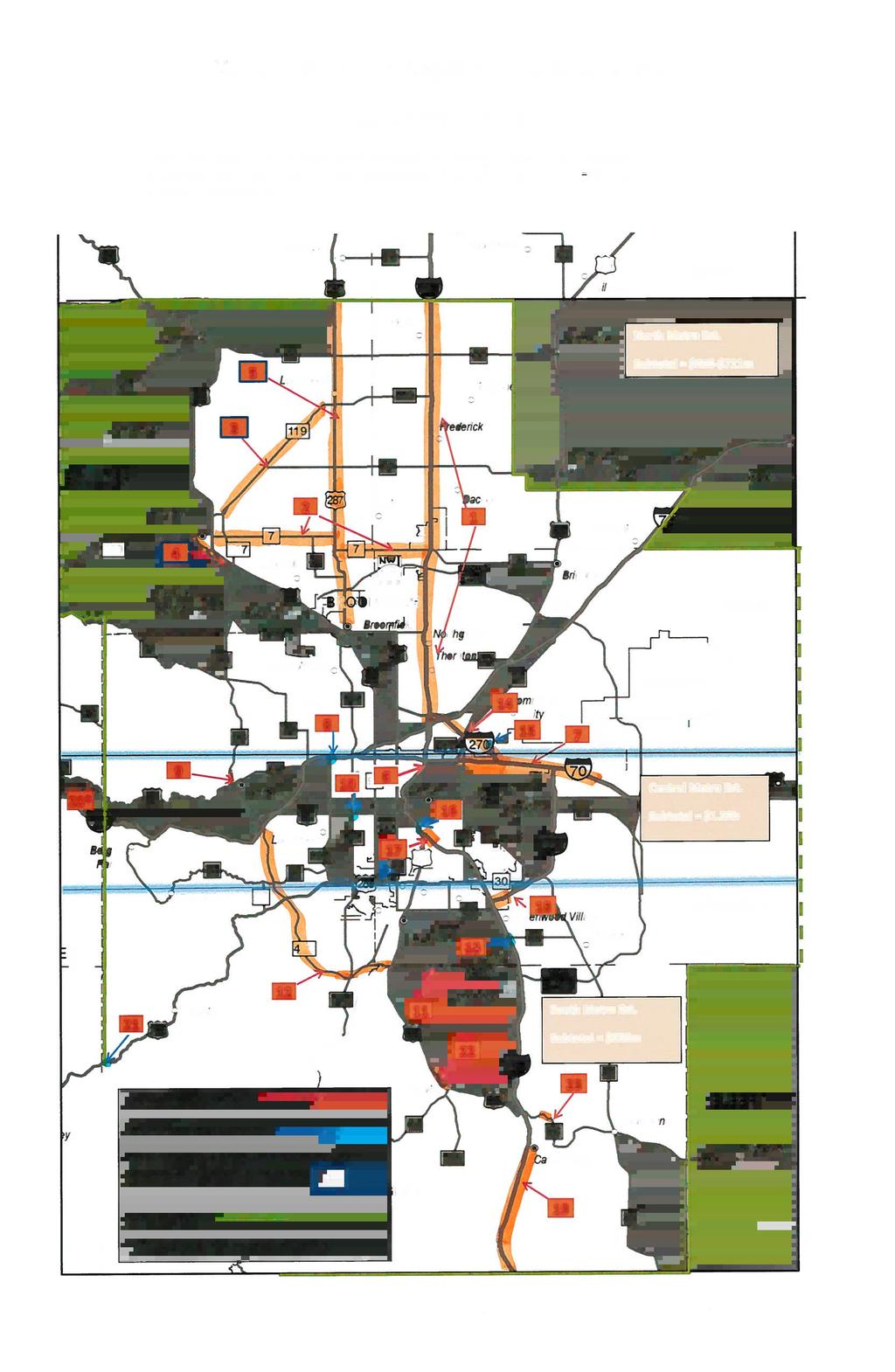
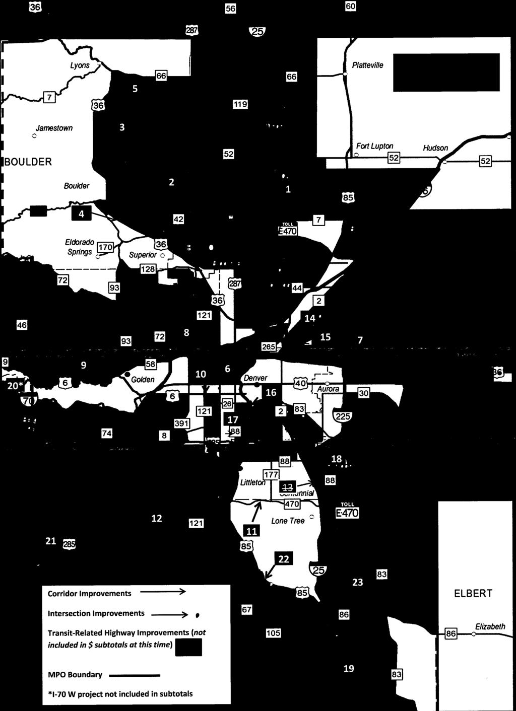
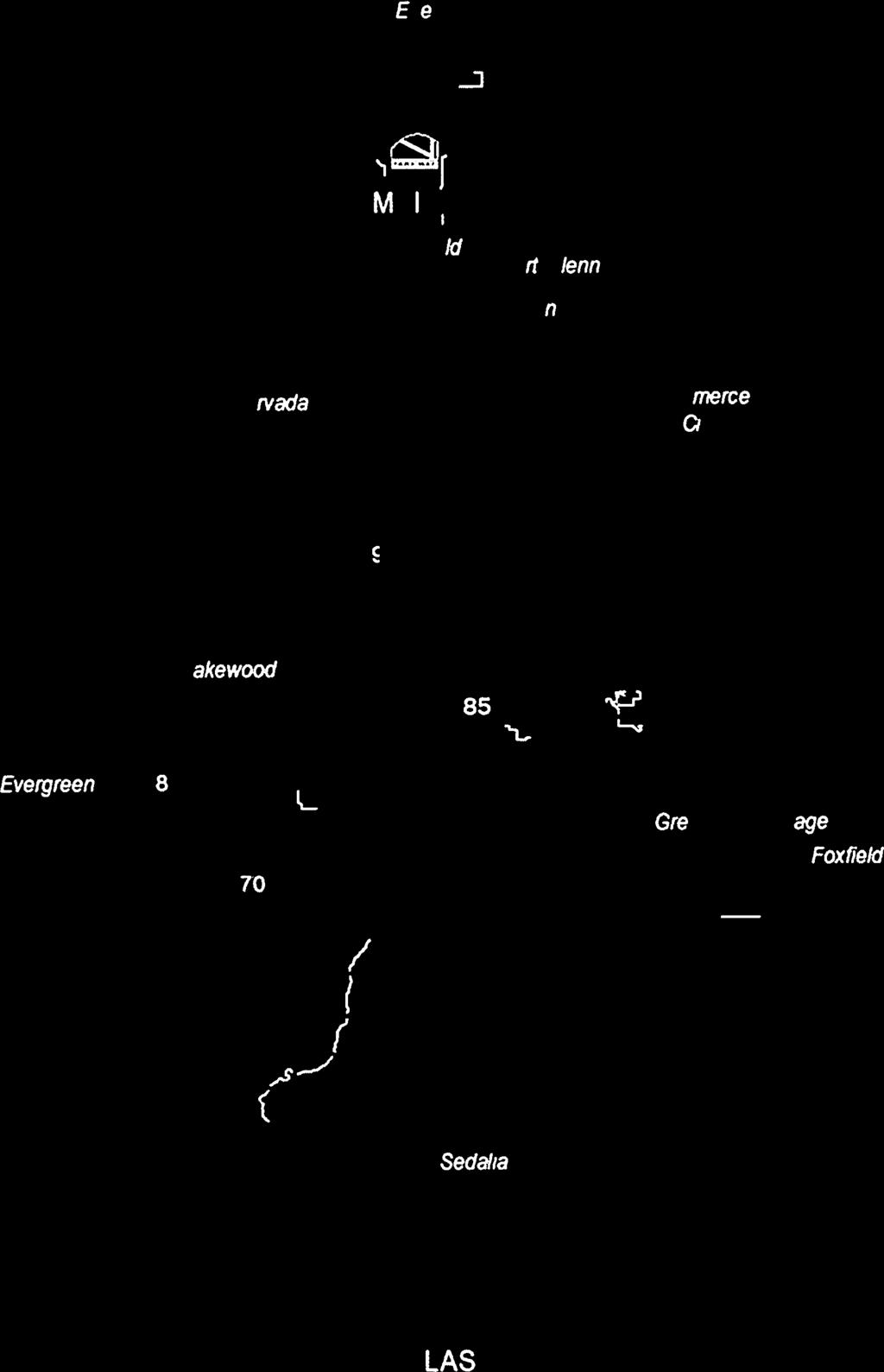
5 MTD DRAFT Project List October 21, 2013 # on Map 1 Project Location I-25 North ($90m in RAMP funding contingent on local support) Project Description* *CDOT s Managed Lane Policy Directive will apply to all new capacity projects listed below. 1) Provide continuous managed lane network from 120th to SH66. Would tie in to current project on I-25 that is constructing these additional lanes from US36 to 120 th. a) Additional lane from 120 th to SH7 b) GP lane conversion OR additional lane from SH7 to SH66 c) Design funding for SH66-north Project Cost (mil) a) $55 b) $20-$75 c) $15 Quadrant/ County Adams 2 SH7 (I-25 to Boulder) 2) Additional improvements from US 36 to SH 7 as identified in current PEL study. Estimated cost dependent upon actual configuration. Implement strategies identified in SH7 study including widening, intersection improvements, and bike, pedestrian and transit improvements. Reconstruct I-25/SH 7 interchange. $78 $178 Boulder/Broomfield 6 I-25 bidirectional managed lanes (DUS to US36) Convert single-direction managed lanes along I-25 to bi-directional for improved mobility. Cost dependent on actual configuration. $200 Denver/Adams 7 I-70 (Colorado Blvd to Tower Rd) Widen and reconstruct I-70 in its current alignment from Colorado Blvd to Tower Road with new lanes to improve mobility, travel time, reliability and safety on the corridor. $860 Denver/Arapahoe 8 I-70 and Kipling Interchange Reconstruct interchange and bridges to relieve congestion and improve safety at interchange at on/off ramps on interstate. $50 9 SH93 (Golden) (Received $20m RAMP funding for US6 and 19th interchange) 10 Realign and widen mainline SH93 in Golden. Additional lanes (one in each direction) would be managed. US-6 and Wadsworth Interchange Reconstruct interchange to improve safety and relieve congestion. $62 11 C-470 Segment 1 (Received $100m in RAMP funding for I-25 to Platte River) $85 Complete Segment 1 from Platte River to Kipling. $100 South Metro/ Douglas 12 C-470 Segment 2 Build one additional lane between Kipling and I-70 to address congestion and safety. $300 Arapahoe Interchange 13 (Received $50.4m in RAMP funding) Reconstruct the I-25 and Arapahoe interchange to accommodate current and future high traffic volumes and improve safety at a $65 million cost (RAMP Candidate). South Metro/ $65 South Metro/ Arapahoe 14 I-270 I-270 widen to add one additional lane each direction from I-76 to I-70 $260 Adams 15 I-270 and Vasquez Interchange reconstruction $50 Adams 16 I-25 Valley Highway Stage 2.0 Finishes interchange at Alameda and provides new on-ramp and new bridges across river. $27 Denver 17 I-25 Valley Highway Stage 3.0 Reconstruct/widen I-25 from Santa Fe to 8th Ave (lane balancing). $50 Denver 18 I-25/I-225 Eliminate bottleneck and weave at DTC Boulevard $40 19 I-25 Widening (Plum Creek to Monument Hill) Address future congestion area btwn Plum Creek and Monument Hill due to wider sections of interstate at north and the south end of this stretch. Funding would implement outcomes of a study. $60 South Metro/ Arapahoe South Metro/ Douglas 20 I-70 Westbound (Floyd Hill to Idaho Springs) Highway and tunnel widening from Floyd Hill to Idaho Springs. $300 Clear Creek 21 US285/Pine Junction US85 (Louviers to Sedalia) SH86 (Founders Pkwy to Woodlands Blvd) Grade separate interchange, add bridge and ramps at Pine Junction. Reconstruct and widen from 2 to 4 lanes from Louviers to Sedalia. Concrete reconstruction from Founders Pkwy to Woodlands Blvd. $20 South Metro $25 South Metro $11 South Metro TOTAL $2.85-$2.90b* Transit Projects with Specific Associated Road Improvements* * Initial examples, specific metro transit improvements subject to NAMS/RTD Review 3 SH119: Boulder Diagonal Hwy (Received $4.456m in RAMP funding for 30th to Foothills Pkwy multimodal improvements) 4 US36 Establish multimodal corridor through BRT, queue jumps and bus lanes.* 1) BRT improvements north of Table Mesa: continues BRT capital improvements into Boulder to improve travel time and reliability. The project is scalable.* 2) Corridor-wide Connections to Bus Rapid Transit --implement facility and program Final Mile improvements to better connect RTD riders to/from the US 36 BRT stations and the surrounding activity centers. TBD estimate will reflect highway elements Boulder Boulder 5 US-287 Create multi-modal corridor and enhance bus transit system to improve corridor mobility. Boulder, Larimer Additional Projects as Requested by CDOT or Local Governments; Not Yet Approved by MTD SH 42 (Paschal to Locke) (requested by Louisville/Boulder Co) Intersection, bicycle, and pedestrian improvements to upgrade SH 42 in Louisville, from a rural undivided two- lane highway to a continuous context sensitive, urban, divided twolane highway with one travel lane in each direction, a raised median, and a left- turn lane. $17.4 North Metro/Boulder County *Expected statewide revenue over 10 years = $2.43b


6
RECEIVED. Be it Enacted by the People of the State of Colorado: SECTION 1. In Colorado Revised Statutes, add part 11 to article 4 of title 43 as
 Initiative 2017-2018 #167 FINAL TEXT INITIATED STATUTE TO AUTHORIZE BONDING FOR TRANSPORTATION FuNDs WITHOUT RAISING TAXESTOFIXOURDAIVINROADS RECEIVED PROPOSED INITIATIVE 2017-20 18 #167 MAR 162018 Be
Chapter 6 Transportation Plan
 Chapter 6 Transportation Plan Transportation Plan Introduction Chapter 6 Transportation Plan Transportation Plan Introduction This chapter describes the components of Arvada s transportation system, comprised
Improving Mobility Without Building More Lanes
 Improving Mobility Without Building More Lanes By Mike Salisbury and Will Toor July 2017 Copyright 2017 by Southwest Energy Efficiency Project. All rights reserved. Photo: Courtesy of the Denver Post Anyone
Santa Clara I-280 CORRIDOR STUDY
 Santa Clara I-280 CORRIDOR STUDY OCTOBER 2017 PREPARED BY: 1.1 Background The I-280 Corridor Study within Santa Clara County is a high-level highway planning study led by the Santa Clara VTA, in partnership
APPENDIX D: SACRAMENTO URBAN AREA TRANSPORTATION PRIORITIES
 1 County County County County 2 Yolo Arterial Roadway Collector Roadway Urban Residential Street Rural Residential Roadway I-80 / U.S. 50 Bus/Carpool Lanes in both directions Richards Blvd PM Yol 80 0.237
Appendix C. NORTH METRO STATION AREA TRAFFIC IMPACT STATEMENT 88th Avenue Station
 Appendix C NORTH METRO STATION AREA TRAFFIC IMPACT STATEMENT 88th Avenue Station Prepared for: Regional Transportation Department and URS Corporation as part of the North Metro EIS David Evans and Associates,
Golden s Plan. For the Highway 6 & 93 Corridor
 Golden s Plan For the Highway 6 & 93 Corridor Purpose of the Study Accommodate regional traffic needs on Highways 6 and 93, as defined by the Northwest Quadrant Feasibility Study. Find a solution that
DULLES AREA TRANSPORTATION ASSOCIATION (DATA) February 18, Susan Shaw, P.E., VDOT, Megaprojects Director
 February 18, Susan Shaw, P.E., VDOT, Megaprojects Director") DULLES AREA TRANSPORTATION ASSOCIATION (DATA) February 18, 2015 Susan Shaw, P.E., VDOT, Megaprojects Director I-66 Corridor Conditions Steady population growth Employment growth in activity centers Congestion
DULLES AREA TRANSPORTATION ASSOCIATION (DATA) February 18, 2015 Susan Shaw, P.E., VDOT, Megaprojects Director I-66 Corridor Conditions Steady population growth Employment growth in activity centers Congestion
APPENDIX G: INTERSECTION NEEDS AT OKEECHOBEE BOULEVARD
 APPENDIX G: INTERSECTION NEEDS AT OKEECHOBEE BOULEVARD INTERSECTION NEEDS AT SR 7 and OKEECHOBEE BOULEVARD SR 7 Extension Project Development and Environment (PD&E) Study From Okeechobee Boulevard (SR
Colorado s elected officials have decreased funding for road and bridge. Revenues that should have gone to roads pursuant to state law have been
 INITIATED STATUTE TO AUTHORIZE BONDING FOR TRANSPORTATION FUNDS WITHOUT RAISING TAXES TO FIX OUR DAMN ROADS PROPOSED INITIATIVE 2017-2018 # Be it Enacted by the People of the State of Colorado: declare
3.0 Future Conditions
 3.0 Future Conditions In order to be able to recommend appropriate improvements to the transportation system of the Town, it is important to first understand the nature and volume of traffic that is expected
Project Description Form 8EE
 Project Description Form 8EE Basic Project Information Submitting Jurisdiction/Agency: Town of Dumfries Project Title: Route 1 (Fraley Blvd) Widening: Brady's Hill Road to Dumfries Road Project Location:
Corridor Advisory Group and Task Force Meeting #10. July 27, 2011
 Corridor Advisory Group and Task Force Meeting #10 July 27, 2011 1 Agenda Recap CAG/TF #9 Public Meeting #2 Summary Single Mode Alternatives Evaluation Results Next Steps 2 3 CAG/TF #9 Recap CAG /TF #9
Route 29 Solutions Projects
 Route 29 Solutions Route 29 Solutions Projects www.route29solutions.org October 10, 2014 Route 29 Widening to Six Lanes Albemarle County This project will widen a 1.8-mile segment of Route 29 from four
RECEIVED. Colorado Secretary of State. t iu. Initiative #22 ORIGINAL TEXT. Be it Enacted by the People of the State of Colorado:
 RECEIVED t iu Colorado Secretary of State t{zp(v INITIATED STATUTE TO AUTHORIZE BONDING FOR TRANSPORTATION FUNDS WITHOUT RAISING TAXES To fix OUR DAMN ROADS PROPOSED INITIATIVE 2017-2018 # Be it Enacted
Bluffdale/ UDOT South High-T Intersection Project Type Operations
 Bluffdale/ UDOT 14600 South High-T Intersection Project Type Operations 14600 South and Redwood Road $ 600,000 $ 550,000 This project is to install a new High-T intersection at Redwood Road and 14600 South
Basalt Creek Transportation Refinement Plan Recommendations
 Basalt Creek Transportation Refinement Plan Recommendations Introduction The Basalt Creek transportation planning effort analyzed future transportation conditions and evaluated alternative strategies for
City of Wayzata Comprehensive Plan 2030 Transportation Chapter: Appendix A
 A1. Functional Classification Table A-1 illustrates the Metropolitan Council s detailed criteria established for the functional classification of roadways within the Twin Cities Metropolitan Area. Table
FY STIP. Austin District. November Quarterly Revisions HIGHWAY STATEWIDE TRANSPORTATION IMPROVEMENT PROGRAM
 FY 2011-2014 STIP STATEWIDE TRANSPORTATION IMPROVEMENT PROGRAM HIGHWAY Austin District November Quarterly Revisions November 2011 FY 2011-2014 Transportation Improvement Program Amendments October 10,
MOUNTAIN HOUSE SPECIFIC PLAN I 9.1 INTRODUCTION ASSUMPTIONS TRANSPORTATION FACILITIES TRANSPORTATION IMPROVEMENTS PHASING 9.
 CHAPTER NINE: TRANSPORTATION AND CIRCULATION 9.1 INTRODUCTION 9.1 9.2 ASSUMPTIONS 9.1 9.3 TRANSPORTATION FACILITIES 9.1 9.4 TRANSPORTATION IMPROVEMENTS PHASING 9.3 LIST OF FIGURES LIST OF TABLES Figure
I-20 ODESSA-MIDLAND CORRIDOR STUDY. Public Meeting for Schematic Design
 I-20 ODESSA-MIDLAND CORRIDOR STUDY Public Meeting for Schematic Design The environmental review, consultation, and other actions required by applicable Federal environmental laws for this project are being,
INTRODUCTION. The focus of this study is to reduce congestion and improve mobility for all modes of transportation. Figure ES-1 Study Corridor Map
 INTRODUCTION The I-280 Corridor Study is a highway planning study led by Santa Clara VTA, in partnership with the City of Cupertino and in coordination with other stakeholders in the study area. The study
LSC TRANSPORTATION CONSULTANTS, INC. 516 North Tejon Street Colorado Springs, CO (719) FAX (719)
 FAX (719)") LSC TRANSPORTATION CONSULTANTS, INC. 516 North Tejon Street Colorado Springs, CO 80903 (719) 633-2868 FAX (719) 633-5430 E-mail: lsc@lsccs.com May 15, 2009 Mr. Davis Farrar Western Slope Consulting, LLC
LSC TRANSPORTATION CONSULTANTS, INC. 516 North Tejon Street Colorado Springs, CO 80903 (719) 633-2868 FAX (719) 633-5430 E-mail: lsc@lsccs.com May 15, 2009 Mr. Davis Farrar Western Slope Consulting, LLC
Draft MOBILITY ELEMENET. Community Meeting May 22, 2013
 Draft MOBILITY ELEMENET Community Meeting May 22, 2013 Agenda Presentation Ira Brown New Mobility Paradigm Movement of People Implementation Q&A Ira Brown and Dave Roseman Small Group Discussion at Each
Regional Transportation Needs Within Southeastern Wisconsin
 Regional Transportation Needs Within Southeastern Wisconsin #118274 May 24, 2006 1 Introduction The Southeastern Wisconsin Regional Planning Commission (SEWRPC) is the official areawide planning agency
Eliminate on-street parking where it will allow for a dedicated bus only lane %
 Traffic Dashboard Priorities Survey Responses Introduction 1) Are you familiar with bus rapid transit (BRT)? a. No, BRT is new to me. 597 23.5% b. I ve heard of BRT, but I don t know much about it. 1,136
Brooklyn Boulevard (County Road 152) Reconstruction Project Phase I. OPEN HOUSE June 20, 2017
 Reconstruction Project Phase I. OPEN HOUSE June 20, 2017") Brooklyn Boulevard (County Road 152) Reconstruction Project Phase I OPEN HOUSE June 20, 2017 Brooklyn Boulevard (County Road 152) Phase I Project Partners Project Lead Other Project Partners include Brooklyn
Brooklyn Boulevard (County Road 152) Reconstruction Project Phase I OPEN HOUSE June 20, 2017 Brooklyn Boulevard (County Road 152) Phase I Project Partners Project Lead Other Project Partners include Brooklyn
I-25 South Gap Project Monument to Castle Rock
 I-25 South Gap Project Monument to Castle Rock Project Overview Castle Rock Town Council April 3, 2018 by Chuck Attardo I-25 South: Monument to C-470 An Important Corridor to Colorado Links the state s
Evaluation Criteria. Record of Decision (ROD) 7/04-8/05 8/05-9/05 TBD TBD TBD. Final EIS (FEIS) Community Outreach
 7/04-8/05 8/05-9/05 TBD TBD TBD. Final EIS (FEIS) Community Outreach") EIS Process We are here 1 2 3 4 5 Scoping Purpose and Need Evaluation Criteria Alternative Development Alternative 7/03-12/03 12/03-2/04 12/03-2/04 1/04-5/04 3/04-8/04 6 7 8 9 10 Draft EIS (DEIS) Evaluation
EIS Process We are here 1 2 3 4 5 Scoping Purpose and Need Evaluation Criteria Alternative Development Alternative 7/03-12/03 12/03-2/04 12/03-2/04 1/04-5/04 3/04-8/04 6 7 8 9 10 Draft EIS (DEIS) Evaluation
I-264 CORRIDOR EVALUATION STUDY. September 7, 2016 Eric Stringfield VDOT Planning Director Chris Lawrence AECOM Senior Transportation Engineer
 I-264 CORRIDOR EVALUATION STUDY September 7, 2016 Eric Stringfield VDOT Planning Director Chris Lawrence AECOM Senior Transportation Engineer Study Overview Interchange Locations Study Context Follow-up
CHAPTER 3.0: TRANSPORTATION IMPACTS
 CHAPTER 3.0: TRANSPORTATION IMPACTS Chapter 4.0 of the Final Environmental Impact Statement (FEIS) provided information about transportation impacts of the Light Trail Transit (LRT) alternative, including:
Bus Rapid Transit Plans
 Twin Cities Region Bus Rapid Transit Plans ULI Minnesota Workshop Connecting Bus Rapid Transit to the Community December 15, 2009 John Levin Director of Service Development Metro Transit Metropolitan Area
University Hill Transportation Study Technical Memorandum Alternatives Modeling and Analysis May 2007
 Technical Memorandum May 2007 Syracuse Metropolitan Transportation Council Edwards and Kelcey with Wallace Roberts and Todd Alta Planning and Design CONTENTS SECTION ONE- INTRODUCTION...1 SECTION TWO-
Transform 66 Project February 4, 2016 Partnering Conference Michigan Department of Transportation American Council of Engineering Companies
 Transform 66 Project February 4, 2016 Partnering Conference Michigan Department of Transportation American Council of Engineering Companies Susan Shaw, PE, CCM, DBIA Megaprojects Director Northern Virginia
Chapter 5 Future Transportation
 Chapter 5 Future Transportation The Future Land Use Plan identifies the desired land use designations. The land uses desired for Crozet depend, in large part, on the success of the transportation system,
COMMUNITY MEETING AGENDA
 COMMUNITY MEETING AGENDA Welcome and Introductions SAFE Presentation Project Presentation Priorities Feedback Next Steps Q&A Santa Cruz Avenue Corridor Study 1 Santa Cruz Avenue Corridor Study Community
3.0 PROJECT DESCRIPTION
 The following section of the Draft EIR contains a description of the proposed Elk Grove Boulevard/SR 99 Interchange Modification project, consistent with the requirements of CEQA Guidelines Section 15124.
Terwillegar Drive Expressway Draft Concept Plan
 Terwillegar Drive Expressway Draft Concept Plan Anthony Henday Drive to Whitemud Drive November 28 5:00-8:00 p.m. December 1 10:00 a.m. - 3:00 p.m. Let s Talk Today you can: Learn about the new direction
Durham Region Long Term Transit Strategy
 Durham Region Long Term Transit Strategy An adaptive, safe, reliable, frequent, accessible and desirable transit system that shapes and connects Durham Region and beyond in an economically and environmentally
1. Operate along freeways, either in regular traffic lanes, in high-occupancy vehicle (HOV) lanes, or along the shoulders.
 lanes, or along the shoulders.") Most decisions about whether or not to use transit involve time and cost, and most transit services are slower than travel by private vehicle. However, when transit is faster or nearly as fast as travel
Most decisions about whether or not to use transit involve time and cost, and most transit services are slower than travel by private vehicle. However, when transit is faster or nearly as fast as travel
Washington DC Section of ITE Project Briefing
 Washington DC Section of ITE Project Briefing November 5, 2015 Renée Hamilton, VDOT, Deputy District Administrator I-66 Outside the Beltway Improvement Area Project Location Virginia 2 Purpose and Need
Freeway System Considerations
 Session 11 Jack Broz, PE, HR Green May 5-7, 2010 Freeway System Considerations Mainline Transit: Shoulder Operations, BRT, Stations HOV, HOT, UPA Interchanges Exit Ramps Entrance Ramps Bridges Local Crossings
Turnpike Projects in Palm Beach County. Palm Beach TPA Update September 20, 2018
 Turnpike Projects in Palm Beach County Palm Beach TPA Update September 20, 2018 Agenda Background Funded Projects Future Project Status Widenings Interchanges Express Lanes Phasing 2 Background 45 Miles
State Road 54/56 Tampa Bay s Northern Loop. The Managed Lane Solution Linking I-75 to the Suncoast Parkway
 State Road 54/56 Tampa Bay s Northern Loop The Managed Lane Solution Linking I-75 to the Suncoast Parkway SUNCOAST PARKWAY Both I 75 and the Suncoast Parkway are planning, or in the process of constructing,
Institute for Real Estate Management Chapter (IREM) 77 VDOT Northern Virginia Megaprojects September 13, 2017
 77 VDOT Northern Virginia Megaprojects September 13, 2017") Institute for Real Estate Management Chapter (IREM) 77 VDOT Northern Virginia Megaprojects September 13, 2017 Susan Shaw, P.E., Megaprojects Director Virginia Department of Transportation Northern Virginia
Institute for Real Estate Management Chapter (IREM) 77 VDOT Northern Virginia Megaprojects September 13, 2017 Susan Shaw, P.E., Megaprojects Director Virginia Department of Transportation Northern Virginia
STUDY ADVISORY COMMITTEE. October 8, 2015
 STUDY ADVISORY COMMITTEE October 8, 2015 Study Purpose evaluate the long-term transportation strategies and investments needed to sustain the county s economic health and quality of life in the coming
5. MODIFICATIONS AT JEANNE D ARC BOULEVARD/REGIONAL ROAD 174 INTERCHANGE INTERSECTION - PUBLIC HEARING COMMITTEE RECOMMENDATION
 5. MODIFICATIONS AT JEANNE D ARC BOULEVARD/REGIONAL ROAD 174 INTERCHANGE INTERSECTION - PUBLIC HEARING COMMITTEE RECOMMENDATION Having held a public hearing, that Council approve the preliminary designs
Planning Study SR 976. Project Advisory Team Meeting May 24, 2017
 ` SR 976 BIRD ROAD/SW 40TH STREET FROM SR 821/HEFT TO SR 5/US-1 Miami-Dade County, Florida FPID No.: 434845-4-22-01 Planning Study Project Advisory Team Meeting May 24, 2017 1 Agenda Introductions Project
2016 Northwest Metro Region Mobility Report. July 2018
 2016 Northwest Metro Region Mobility Report July 2018 Table of Contents Executive Summary... 6 US 36 Express Lanes Project... 6 2015 US 36 Communities Transportation Mode Share... 7 Preliminary Outcomes
Road Diets FDOT Process
 Florida Department of TRANSPORTATION Road Diets FDOT Process Humberto Castillero, PE, PTOE Roadway Design Office Purpose of Guide Develop a statewide lane elimination review process Balance state & local
Executive Summary June 2015
 Executive Summary June 2015 Highway 112 Corridor Study Benton and Washington Counties Executive Summary June 2015 Prepared by Transportation Planning and Policy Division Arkansas State Highway and Transportation
DEKALB COUNTY. 22. Priority Projects for DeKalb County
 DEKALB COUNTY 2 0 1 4 T R A N S P O R T A T I O N P L A N 22. Priority s for DeKalb County Following the completion of the project prioritization metrics, each project was able to be compared to other
EL CAMINO REAL BUS RAPID TRANSIT (BRT) PROJECT
 PROJECT") Agenda Item #4.2 EL CAMINO REAL BUS RAPID TRANSIT (BRT) PROJECT VTA BOARD WORKSHOP MAY 1, 2015 ABOUT THIS PRESENTATION CONTEXT Existing conditions and planning for growth WHAT IS THE PROJECT? Project alternatives
Agenda Item #4.2 EL CAMINO REAL BUS RAPID TRANSIT (BRT) PROJECT VTA BOARD WORKSHOP MAY 1, 2015 ABOUT THIS PRESENTATION CONTEXT Existing conditions and planning for growth WHAT IS THE PROJECT? Project alternatives
Columbia Pike Implementation Team (CPIT) Meeting
 Meeting") Columbia Pike Implementation Team (CPIT) Meeting November 30, 2010 Agenda Introductions / Purpose of Meeting Review of project goals Multimodal project: 10% street design between the curbs Discussion Multimodal
Columbia Pike Implementation Team (CPIT) Meeting November 30, 2010 Agenda Introductions / Purpose of Meeting Review of project goals Multimodal project: 10% street design between the curbs Discussion Multimodal
Welcome. Thank you for your interest in the Lewis & Clark Viaduct Concept Study
 Welcome Thank you for your interest in the Lewis & Clark Viaduct Concept Study Please use the arrows in the upper left hand corner to navigate through the presentation. Use the envelope icon to ask a question
Los Altos Hills Town Council - June 18, 2015 Palo Alto City Council June 22, AGENDA ITEM #2.B Presentation
 Los Altos Hills Town Council - June 18, 2015 Palo Alto City Council June 22, 2015 AGENDA ITEM #2.B Presentation Previous Presentations Los Altos Hills Town Council in May 2014 and February 2015 Palo Alto
Princeton Avenue and Spruce Street Transportation and Site Access Enhancements Project
 Princeton Avenue and Spruce Street Transportation and Site Access Enhancements Project Mercer County Planning Division AECOM Transportation (formerly DMJM Harris) January 29, 2009 Agenda Project Status
Project Description Form 6V
 Project Description Form 6V Basic Project Information Submitting Jurisdiction/Agency: Prince William County Project Title: Route 15 Widening: Route 55 to south of RR tracks & Construct RR Overpass Project
Comments EXECUTIVE SUMMARY
 Comments 1. Under any Alternatives, MCDOT should provide better at-grade pedestrian crossing of Georgia Avenue and Forest Glen Road, including improved crosswalks with wider medians and adequate signal
7.0 FREEWAYS CONGESTION HOT SPOT PROBLEM & IMPROVEMENT PROJECT ANALYSIS & DEFINITION
 7.0 FREEWAYS CONGESTION HOT SPOT PROBLEM & IMPROVEMENT PROJECT ANALYSIS & DEFINITION 7.1 INTRODUCTION & METHODOLOGY FEASIBILITY REPORT Congestion hot spot problem locations have been assessed using the
Dulles Area Transportation Association. October 11, Susan Shaw, P.E., Megaprojects Director Virginia Department of Transportation
 Dulles Area Transportation Association October 11, 2017 Susan Shaw, P.E., Megaprojects Director Virginia Department of Transportation Transform 66: Outside the Beltway 2 Project Overview Multimodal improvements
Providing an Efficient and Multi-modal Transportation System
 Providing an Efficient and Multi-modal Transportation System Welcome and Introductions The Plan Process Transportation Overview Workshop Discussions Report Out and Next Steps AGENDA Comprehensive Plan
Environmental Assessment Findings & Recommendations. Public Hearing November 13, 2014
 Environmental Assessment Findings & Recommendations Public Hearing November 13, 2014 Welcome! Welcome and Introductions Project and Environmental Assessment Overview Public Comments Adjourn Purpose of
Route 7 Corridor Study
 Route 7 Corridor Study Executive Summary Study Area The following report analyzes a segment of the Virginia State Route 7 corridor. The corridor study area, spanning over 5 miles in length, is a multi
Defining Purpose and Need
 Advanced Design Flexibility Pilot Workshop Session 4 Jack Broz, PE, HR Green May 5-6, 2010 Defining Purpose and Need In your agency s project development process, when do design engineers typically get
Hennepin County Transportation Department
 Hennepin County Transportation Department Complete Streets Design and Implementation Prepared for the Complete Streets Task Force Craig Twinem, P.E. Design Division Manager Tom Johnson, P.E. Transportation
I-35W Solutions Alliance Project Update July 13, 2017
 Title I-35W Solutions Alliance Project Update July 13, 2017 Evaluating the potential for Bus Rapid Transit and MnPASS Express Lanes in the southwest Metro, Investigating options for improved bus service
Congress Avenue. Palm Beach MPO Subcommittee Meetings December 2017
 1 Congress Avenue Palm Beach MPO Subcommittee Meetings December 2017 2 Agenda Study Purpose Study Process Multimodal Alternatives Development Next Steps *ACTION ITEM: CONFIRM ALTERNATIVES TO MOVE INTO
State Highway 16 Kuna-Mora Road to Ada/Gem County Line
 Background Update! (February 2018): This project has been partially funded; see below. State Highway 16 is the main commuter route from Gem County to the Treasure Valley. An increase in traffic and accidents
North County Metro. Community Summaries, Maps and Matrices
 North County Metro Interstate 15 Mountain Meadow Road / Mirar De Valle Road Deer Springs Road Overview Sponsor Group Preferences The North County Metro sub-region includes two represented communities:
Cottonwood Heights HAWK Pedestrian Crossing on Fort Union Blvd. Project Type Capital Improvement
 Cottonwood Heights HAWK Pedestrian Crossing on Fort Union Blvd. At West Side of Mountview Park Entrance (Approx. 1600 East) $ 206,800 $ 192,800 Install a HAWK Pedestrian Crossing System on Fort Union Boulevard,
Highway 217 Corridor Study. Phase I Overview Report
 Highway 217 Corridor Study Phase I Overview Report November 3, 24 BACKGROUND AND OVERVIEW Study purpose The Highway 217 Corridor Study is developing multi-modal transportation solutions for traffic problems
Description: Widen I-64 to 6 lanes from I-265 to the KY 53 interchange in Shelby County.
 I-64 KIPDA ID # 350 Project Type: ROADWAY CAPACITY Description: Widen I-64 to 6 lanes from I-265 to the KY 53 interchange in Shelby County. Purpose: Project will improve capacity and address safety concerns.
TRANSPORTATION & MOBILITY
 TRANSPORTATION & MOBILITY ROADWAY SYSTEM There are approximately 40 miles of roadways in Manitou Springs. For planning purposes, roadways are typically assigned a functional classification which defines
Base Information. 1. Project Title State Highway 7 Preliminary & Environmental Engineering
 Part 1 Base Information 1. Project Title State Highway 7 Preliminary & Environmental Engineering 2. Project Start/End points or Geographic Area Provide a map with submittal, as appropriate 3. Project Sponsor
Bay to Bay Boulevard Complete Streets Project
 Bay to Bay Boulevard Complete Streets Project Dale Mabry Highway to Bayshore Boulevard February 08, 2018 Photo Source: Tampa Bay Times Alessandra Da Pra Meeting Format Introduction Resurfacing Information
CHIEF PEGUIS TRAIL EXTENSION WEST
 1 PRELIMINARY DESIGN OF THE CHIEF PEGUIS TRAIL EXTENSION WEST Public Information Session June 6, 2017 Welcome 1 Thank you for attending today s public information session. The following boards provide
COMMUNITY WORKSHOP (CW) 3 February 21, 2015
 3 February 21, 2015") QEW Improvements QEW Improvements COMMUNITY WORKSHOP (CW) 3 February 21, 2015 1 WORKSHOP PURPOSE MOVING FORWARD Review of Technically Preferred alternative Seeking feed back for progressing to next design
QEW Improvements QEW Improvements COMMUNITY WORKSHOP (CW) 3 February 21, 2015 1 WORKSHOP PURPOSE MOVING FORWARD Review of Technically Preferred alternative Seeking feed back for progressing to next design
Citizen Advisory Group Meeting #8 May 5, Welcome. Today s meeting will focus on: Land Use & Transportation CHARLOTTEPLANNING.
 Citizen Advisory Group Meeting #8 May 5, 2010 Welcome. Today s meeting will focus on: Land Use & Transportation CHARLOTTEPLANNING.ORG Meeting Agenda Handouts: o Meeting Agenda o Summary of East Seventh
Overview. Illinois Bike Summit IDOT Complete Streets Policy Presentation. What is a Complete Street? And why build them? And why build them?
 Overview Illinois Bike Summit IDOT Complete Streets Policy Presentation Aren Kriks, P.E. District One Bicycle Coordinator and Bureau of Programming Project Engineer History of Complete Streets IDOT Policy
Creating the Future Bruce B Downs Blvd
 Creating the Future Bruce B Downs Blvd How things look today May not be how things look in the future. Bruce B Downs PD&E Study 2003 Construction programmed 2009, Palm Springs to Pebble Creek Tampa Rail
Complete Street Analysis of a Road Diet: Orange Grove Boulevard, Pasadena, CA
 Complete Street Analysis of a Road Diet: Orange Grove Boulevard, Pasadena, CA Aaron Elias, Bill Cisco Abstract As part of evaluating the feasibility of a road diet on Orange Grove Boulevard in Pasadena,
FI-2 I-66 Between Route 29, Lee Highway and Route 15, James Madison Highway
 TRANSPORTATION PLAN INTENT Transportation is the key to the economic and social development of Prince William County and especially to the I 66/Route 29 Sector Plan area. This includes transportation for
 MEMORANDUM - CITY OF PASADENA Department Of Transportation DATE: OCTOBER 21, 2008 TO: ENVIRONMENTAL ADVISORY COMMISSION FROM: ~ FRED C. DOCK, DIRECTOR OF TRANSPORTATION SUBJECT: UPDATE ON DEPT. OF TRANSPORTATION
NEW BRAUNFELS SEGUIN AREA REGIONAL TRANSPORTATION DRAFT PLAN NEW BRAUNFELS CITY COUNCIL MEETING
 NEW BRAUNFELS SEGUIN AREA REGIONAL TRANSPORTATION DRAFT PLAN NEW BRAUNFELS CITY COUNCIL MEETING February 13, 2012 This regional transportation plan will: 1. Review existing plans for the cities and counties,
VDOT I-66 Inside the Beltway Eastbound Widening Environmental Assessment. Staff Recommendations
 VDOT I-66 Inside the Beltway Eastbound Widening Environmental Assessment Staff Recommendations Department of Environmental Services Transportation January 28, 2017 Timeline of Transform66 June 2012: I-66
Municipal Class EA To Address Traffic Congestion On The Ontario Street Corridor (Grand Bend) Public Information Meeting June 4, 2018
 Public Information Meeting June 4, 2018") Municipal Class EA To Address Traffic Congestion On The Ontario Street Corridor (Grand Bend) Public Information Meeting June 4, 2018 Background Agenda Traffic Study Update Class EA Alternatives Bridge
Municipal Class EA To Address Traffic Congestion On The Ontario Street Corridor (Grand Bend) Public Information Meeting June 4, 2018 Background Agenda Traffic Study Update Class EA Alternatives Bridge
FM #: ETDM #: 11241
 SR 826/Palmetto Expressway PD&E Study From SR 93/I 75 to the Golden Glades Interchange FM #: 418423 1 22 01 ETDM #: 11241 Agency/ Kick Off Meeting October 27, 2011 2 Location Map From SR 93/I 75 to Golden
Project Fact Sheet. August 1,
 Fact Sheet City of Gainesville Transportation Master Plan In December 2012, the Mayor and City Council selected a consultant team of Pond & Company and Arcadis to prepare the City of Gainesville Transportation
North Hollywood to Pasadena BRT Corridor Technical Study. Eco-Rapid Transit/Orange Line Development Authority March 8, 2017
 North Hollywood to Pasadena BRT Corridor Technical Study Eco-Rapid Transit/Orange Line Development Authority March 8, 2017 Agenda 1. Background 2. Corridor Review 3. Key Challenge 4. Preliminary BRT Alignments
CITY OF SEATTLE RESOLUTION. WHEREAS, the Washington State Department of Transportation (WSDOT) led the Seattle
 led the Seattle") SDOT SR0 Design Refinements RES August, 0 Version #D 0 CITY OF SEATTLE RESOLUTION..title A RESOLUTION relating to the State Route 0, Interstate to Medina Bridge Replacement and High Occupancy Vehicle Project;
SDOT SR0 Design Refinements RES August, 0 Version #D 0 CITY OF SEATTLE RESOLUTION..title A RESOLUTION relating to the State Route 0, Interstate to Medina Bridge Replacement and High Occupancy Vehicle Project;
Bike San Mateo County San Mateo County Bicycle Plan Recommendations August 30, 2010
 Policy and Procedures Develop and Implement a Complete Streets Policy to comply with DD-64-R1 and AB1358 Commencing January 1, 2011, AB1358 requires that the legislative body of a city or county, upon
TRANSPORTATION TRAINING TOPICS. April 6, 2010
 TRANSPORTATION TRAINING TOPICS April 6, 2010 Roles of Transportation Providers Context and Policy Makers Division of Transportation and Traffic Other City Operations Other Transportation Operators CMA
Maryland State Highway Mobility Report. Morteza Tadayon
 Maryland State Highway Mobility Report Morteza Tadayon Background Mobility is a Key Performance Area (KPA) in the SHA Business Plan SHA adopts a performance based approach Monitors Highway System to identify
FY 2018 TRANSPORTATION CAPITAL PROGRAM New Jersey Department of Transportation Projects
 Camden County Bus Purchase Project ID Numbers: D0601 / 068082 In the DVRPC region, a combination of fixed route, subscription, and demand responsive transit services are provided in Camden County by Senior
I-66 Corridor Improvements Route 15 to I-495. November 2014
 I-66 Corridor Improvements Route 15 to I-495 November 2014 I-66 Corridor: Haymarket to the Beltway = Park and Ride Lots 2 Purpose and Need Improve multimodal mobility along the I-66 corridor by providing
Technical Working Group November 15, 2017
 Technical Working Group November 15, 2017 Welcome and Introductions Project Partners Regional Transportation District (RTD) Colorado Department of Transportation (CDOT) Denver Regional Council of Governments
Main-McVay Transit Study: Phase 2 Options Definition and High Level Constraints Evaluation
 Main-McVay Transit Study: Phase 2 Options Definition and High Level Constraints Evaluation APRIL 2016 A collaborative study between: For Additional Information or to Comment If you would like additional
Sarasota/Manatee MPO Project Priorities 2016 Adopted April 25, 2016
 All projects on the following priority lists should be implemented in the priority sequence listed, as consistent with the fiscal constraints identified in the MPO s adopted Long Range Transportation Plan
Bus Rapid Transit on Silicon Valley s El Camino Real: Working Together to Create a Grand Boulevard Steven Fisher
 Bus Rapid Transit on Silicon Valley s El Camino Real: Working Together to Create a Grand Boulevard Steven Fisher Senior Transportation Planner Santa Clara Valley Transportation Authority San Jose, CA How