Feasibility Study. Expo-Downtown Bicycle Connector
|
|
|
- Clarissa Hubbard
- 5 years ago
- Views:
Transcription


1 Feasibility Study Expo-Downtown Bicycle Connector May 2017

2 Table of Contents Introduction... 2 Project Goals... 2 Study Scope... 2 Community Engagement... 3 Project Description... 6 Considerations... 6 Recommended Project... 9 Alternatives Venice-Culver Alternative...13 Hoke-Culver Alternative...14 Washington Boulevard South Side Alternative...14 Lindblade Alternative...15 Cost Estimate Implementation Page

3 Introduction Washington Boulevard is Culver City s main street, running from east to west through the Arts District, TOD District, and Downtown Culver City and continuing to the western city boundary. In 2012, the Metro Expo Line opened to Culver City, creating additional demand for walking and biking along Washington, as well as opportunities for property owners to pursue transit-oriented development. As it develops over time, the Washington corridor will become home to even more destinations serving people who live, work, and visit Culver City. Within the context of an evolving corridor, the City Council directed the Public Works Department to evaluate the feasibility of connecting the Expo Station to Downtown Culver City with a high-quality bike facility. A strong bike connection on Washington Boulevard will complement the City s efforts to encourage walkable, transit-oriented development by reshaping the street to be more bicycle-friendly. Improving accommodations for bicycles will also prepare the corridor for additional mobility options in the future, such as bike share. Project Goals This project has multiple goals, including: Improve bicycle & pedestrian safety in the TOD District, Promote mobility options for people of all ages and abilities, Increase access by bicycle to businesses and other local destinations, and Promote community health and sustainability. Study Scope In June 2016, the City retained TranspoGroup to develop project alternatives that would meet these goals. The findings and recommendations in this report are based on the feasibility analysis conducted by TranspoGroup. City staff considers the recommended project to be the best feasible project given the opportunities and constraints that exist in the corridor and the desire to minimize impacts to driveway access, vehicle capacity, transit operations and parking. The study does include sufficient information to seek right-of-way dedications and other mitigations from pending developments to enable the future implementation of the recommended project. This feasibility study is not an exhaustive study of the proposal s potential benefits and impacts. The feasibility study only addresses geometric design issues that would be considered fatal flaws for the project concept. As this concept is refined, it will need to undergo more detailed study and environmental review, including a traffic assessment and more detailed cost estimate. At that point, decision makers will have more information to consider potential tradeoffs. Other potential issues would be addressed during engineering. 2 Page

4 Community Engagement The City s newly formed Bicycle & Pedestrian Advisory Committee (BPAC) played a central role in community engagement for this project. The BPAC includes perspectives of residents, businesses, youth, older adults, people with disabilities, and the school district. This project affects all of these segments of the community in different ways. For example, the project is designed to make it easier for residents in nearby neighborhoods to access the Expo Line and Downtown and for students to ride to Linwood Howe from the Arts District neighborhood, but would reduce onstreet parking in front of some businesses. At multiple meetings and a public workshop, the BPAC considered comments from the public submitted at each meeting and via . At the BPAC s inaugural meeting on September 8th, 2016, TranspoGroup presented the initial conceptual project proposal based on their preliminary analysis of opportunities and constraints. Based on feedback from the BPAC and members of the public in attendance, TranspoGroup and City staff continued to develop the concept and engage with affected stakeholders. City staff met directly with representatives of all major stakeholders, including each developer with a pending project, Howard Industries, and Sony Pictures, to present the project and discuss any issues or concerns. On January 7th, 2017, the BPAC hosted a public workshop to gather additional stakeholder input and gauge public support for the proposed project. This workshop was Photos from January 7th Workshop advertised to 4,000 households, businesses and property owners with postcards, as well as via the City s social media and local press coverage. Approximately 50 people attended the workshop. An additional 19 people submitted comments for the BPAC s consideration via . On January 19th, 2017, the BPAC considered the project again at its regular meeting. TranspoGroup and City staff addressed questions and concerns raised at the workshop and via comments and stakeholder meetings. At this meeting, the BPAC voted unanimously to support the recommended project concept after additional consultation with affected stakeholders between Ince and Robertson regarding turn lane and access issues. In February, City staff met with the managers of both the Honda and Toyota dealerships. In March, City staff met again with representatives from Sony Pictures at the Imageworks campus to evaluate concerns about driveway access. In response to concerns raised by these stakeholders, City staff developed additional alternatives discussed later in this report for further evaluation. 3 Page


5 Approximately 50 people attended the January 7th public workshop In March, the TOD Visioning Study, led by the Community Development Department, kicked off public outreach for a planning process that covers much of the same geography as the Expo to Downtown Bicycle Connector. The consultant team for the Visioning Study has been briefed on the status of this project and has incorporated information about it into their outreach process. Recommendations from the Visioning Study can be incorporated into the future design and engineering phase of the Expo to Downtown Bicycle Connector. On March 26th, the City partnered with the Southern California Association of Governments (SCAG) GoHuman Initiative to set up a pop-up demonstration project concurrent with CicLAvia. Hundreds of people rode along the temporary protected bike lane on their way to and from CicLAvia to get a sense of what the project could look like. Photos from March 26th Demonstration Project 4 Page

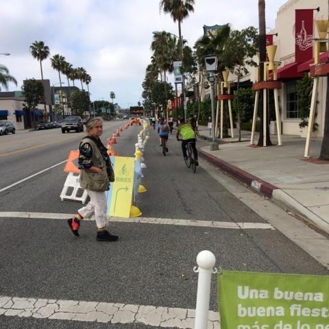
6 Photos from March 26th Demonstration Project 5 Page
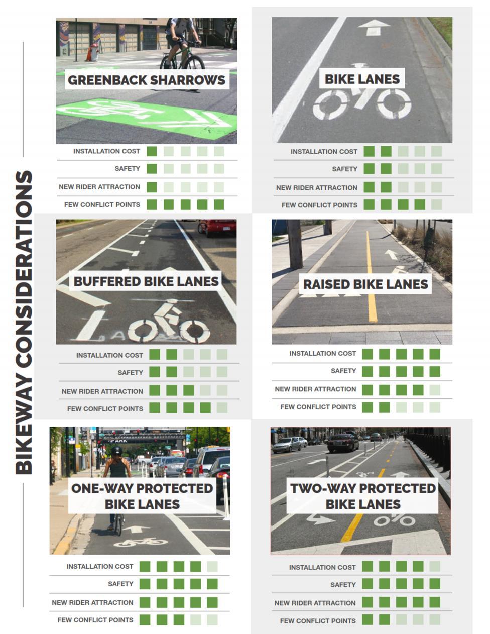
7 Project Description The recommended project would install a two-way protected bike lane on Washington Boulevard connecting to the Expo Bike Path at Wesley Street, the Expo Line station, and Town Plaza in Downtown Culver City. The project would also install a two-way protected bike lane on Robertson Boulevard from Washington to Venice Boulevard in order to connect the Washington facility to the Expo Phase II Bike Path north of Venice. Considerations TranspoGroup evaluated multiple bikeway options for the project corridor, considering the quality of the bike facility offered and the relative tradeoffs of cost, parking, and traffic. In analyzing feasibility of each option, TranspoGroup and City staff considered: Safety for bicyclists, pedestrians, transit users, and drivers Potential conflict points, including driveway and intersection conflicts Connectivity to key destinations, including the Expo Station and both phases of the Expo Bike Path Potential to increase delay for vehicles Right-of-way constraints Location of bus stops Location of storm drains and other significant infrastructure Cost-effectiveness The project area s specific constraints include the narrow width of parts of Washington Boulevard compared to the minimum space needed for a bike lane buffer, the configuration and location of bus stops, and the need to preserve turn lanes for critical movements. TranspoGroup considered implementing the sharrows and bike lanes identified in the City s 2010 Bicycle & Pedestrian Master Plan, but these options do not meet the project goals of providing a bikeway that will attract new riders and serve people of all ages and abilities. Protected bike lanes are the international best practice for providing safe and comfortable bike facilities on major streets. TranspoGroup evaluated multiple options for installing protected bike lanes, including one-way protected bike lanes, two-way protected bike-lanes, and raised bike lanes. One-way protected bike lanes are generally the preferred approach whenever feasible due to relatively simpler design and the more intuitive experience of riding alongside traffic moving in the same direction. However, the space required for one-way protected bike lanes would require severe impacts to vehicle capacity and/or turn restrictions due to Washington Boulevard s relatively narrow width. 6 Page

8 A two-way protected bike lane in Redondo Beach functions like a bike path on one side of the street. Photo: Rock Miller A two-way protected bike lane is a novel solution to the unique constraints that exist on Washington Boulevard that make other potential alternatives infeasible or less favorable. A two-way protected bike lane is like a bike path on one side of the street, completely separated from traffic lanes by bollards or another physical barrier. This concept would include dedicated bike signals at intersections and special markings at driveways to mitigate conflict points between bicyclists, pedestrians, and drivers. TranspoGroup believes this concept best meets the City s objective of creating a safe and comfortable facility for people who may not feel comfortable riding a bike in traffic. 7 Page
9 8 Page

10 Recommended Project The recommended two-way protected bike lane would provide a direct connection from the Expo Line station on the north side of Washington Boulevard to Town Plaza on the south side of the street by switching sides midway along the corridor. This configuration provides better access to likely destinations and connects seamlessly with the proposed bike lane on Robertson, while carefully avoiding the constraints imposed by the bus stops at the Robertson/Higuera intersection. This intersection is the pinch point for the project, where the proposed bike lanes converge and the right-of-way is at its narrowest. Therefore, the project s feasibility is dependent on securing additional right-of-way in this location. Washington Boulevard varies in width from 60 feet from curb to curb on the west end to nearly 80 feet on the east end. As a result, the recommended project changes significantly from one end to the other. On the more constrained western end, every foot is precious and each street element is brought down to minimum acceptable widths. Additional right-of-way is necessary at the Robertson/Higuera intersection in order to install a right turn lane that cannot fit within the existing width. On the eastern end, there is room for elements like on-street parking and an eastbound supplemental bike lane. The recommended project is further described on the following boards that were presented at the January 7th public workshop. 9 Page

11 10 P a g e

12 11 P a g e

13 12 P a g e


14 After additional consultation with Sony Pictures, City staff evaluated a variation of the recommended project between the Ince and Robertson intersections (Cross Section A, above) that would retain the center turn lane for the entire length of the block in order to maintain access to the principal driveway for Sony s Imageworks campus. City staff conducted traffic counts at both the front and rear driveways of the campus in order to assess demand for turning movements into and out of each driveway and the potential impact if the turn lane was removed. City staff concurs with Sony that there is sufficient left turn volume to justify retaining the center turn lane. A variation of Cross Section A retains the center turn lane by installing minimum-width lanes. Alternatives At the January 7th workshop and other stakeholder meetings, several stakeholders requested more information about potential alternatives to the recommended alignment. City staff reviewed the following alternatives: Venice-Culver Alternative Venice and Culver Boulevards provide a relatively direct connection between the Metro Bike Hub at Venice/Robertson and Downtown Culver City. This alternative is not recommended for the following Tradeoffs of recommended project reasons: Venice is a very wide street that is not conducive to crossing. This alignment would require bike riders traveling from the Expo Station to Downtown to cross Venice twice, adding substantial time delay and discomfort to what would otherwise be a very short trip. 13 P a g e
15 The Expo Line bridge over Venice constrains the width of the westbound bike lane on Venice, likely making a protected bike lane infeasible between Robertson and Culver without the loss of a westbound traffic lane. A protected bike lane on Culver would require the loss of one traffic lane in each direction and substantial reconstruction of the entrance to the Ince parking garage. Extending the protected bike lane on Culver into Downtown Culver City would require the loss of onstreet parking and/or a traffic lane in each direction. This alternative would not directly connect Culver City residents in the Arts District or future residents in the TOD District to Downtown Culver City. This alternative would not provide a strong connection to Linwood Howe for students living in eastern Culver City. The majority of the project would be in the City of Los Angeles, so the City would not have the authority to pursue this alignment. This alternative is not recommended for further consideration. Hoke-Culver Alternative Hoke Avenue is an alley that runs parallel to Washington and Venice and provides access to a small business district behind the Honda dealership. City staff assessed Hoke s suitability as a bike facility and does not recommend it for the following reasons: Like the Venice-Culver alternative, the majority of the project would be in the City of Los Angeles, so the City would not have the authority to pursue this alignment. Hoke is not a continuous street and therefore this route would require acquisition of the property currently used as a drive-thru by Wendys, resulting in a significant economic impact on the property owner and a commensurately high sale price. This property is located within the City of Los Angeles. Hoke is not sufficiently wide for a dedicated bicycle facility. Instead, this alternative would be a shared street. A protected bike lane on Culver would require the loss of one traffic lane in each direction and substantial reconstruction of the entrance to the Ince parking garage. A new signalized intersection on Culver or alternative crossing treatment would be necessary to connect to Hoke. Extending the protected bike lane on Culver into Downtown Culver City would require the loss of onstreet parking and/or a traffic lane in each direction. Hoke does not provide a direct connection to the Expo Line station without additional infrastructure on Robertson and Venice. Hoke is a relatively isolated alley that runs along the backside of a strip mall. It is unlikely to provide a pleasant experience for biking and walking, particularly at night. This alternative would not directly connect Culver City residents in the Arts District or future residents in the TOD District to Downtown Culver City. This alternative would not provide a strong connection to Linwood Howe for students living in eastern Culver City. This alternative is not recommended for further consideration. Washington Boulevard South Side Alternative Several residents of the Arts District neighborhood requested that the bike lane be located on the south side of Washington Boulevard instead of switching to the north side at Robertson/Higuera. City staff agrees that this would provide a more direct connection to the neighborhood, though at the expense of 14 P a g e
16 providing a less direct connection to the Expo Station. Despite the apparent benefits of this alternative, it was not recommended as the preferred alternative in this study for the following reasons: There is not adequate width for both the bike lane and a bus stop at the corner of Washington and Robertson/Higuera. (The recommended alternative avoids this conflict by changing sides of the street.) Keeping the bike lane on the south side of Washington would require the removal of the eastbound bus stop at Robertson/Higuera. This bus stop is the transfer point between Culver CityBus Line 1 and all of the buses that use the Robertson Transit Center. Requiring bus passengers to alight at Landmark and then walk back to Robertson would add a considerable time penalty to these transfers. Higuera is the main collector street for the Lucerne-Higuera neighborhood, so this bus stop serves a substantial number of residents. There is not adequate right-of-way at the southwest corner of Washington and Robertson/Higuera to separate turning movements from bike movements. This would need to be addressed in one of three ways: o Right-of-way could be acquired from the adjacent property, which could potentially impact the building. (In contrast, the additional right-of-way at the northeast corner needed for the recommended alternative is currently occupied by landscaping.) o Bike movements could have a dedicated phase without concurrent vehicle movements. This would create additional vehicle delay on Washington compared to the recommended alternative. It would also cause additional delay for bike riders, which may discourage use of the bike lane. o Right turns could be restricted from eastbound Washington onto Higuera, limiting access to the neighborhood. This alternative would require a new signalized crossing between Landmark and National to reach the Expo Station, in close proximity to these existing signalized intersections. Otherwise, bicyclists trying to reach the Expo Station from the west would have to ride past the station to National, cross at a crosswalk and then walk back to the station on the sidewalk. These constraints are primarily driven by the geometry of the Robertson/Higuera intersection. This alternative has sufficient merit to justify additional study of potential solutions for this intersection. City staff recommends revisiting this alternative during preliminary engineering to reassess feasibility. Lindblade Alternative During a site visit with Sony Pictures regarding potential impacts to access for their front driveway, Sony suggested routing the bike lane behind the Imageworks campus on Higuera, Lindblade, and Ince. While this alternative would be 1/10th of a mile longer, it would have the same number of signalized intersections and driveway crossings as the recommended project and therefore a comparable travel time for bicycle riders. However, it would result in significantly greater parking loss than the recommended project as well as the loss of a dedicated right turn lane on Ince. These tradeoffs warrant additional consideration. City staff recommends exploring this alternative during preliminary engineering in consultation with Sony. 15 P a g e


17 Cost Estimate TranspoGroup prepared the following preliminary cost estimate for the recommended project. This cost estimate would install a relatively basic level of infrastructure. The City could choose to provide a greater level of design and aesthetics by considering additional streetscape elements where sufficient room is available, such as additional curb separation, planters, or decorative paving. Aesthetic decisions should be made in consultation with the Washington Boulevard Streetscape Plan, the TOD Visioning Study, and stakeholders. Protected bike lanes can include planters (above) or concrete curbs (below) for enhanced separation. 16 P a g e

18 17 P a g e

19 Implementation The recommended project is a major capital project that would require multiple years to implement. At this time, City staff recommends further developing the project to shovel-ready status within the next fiscal year. These steps would include developing a more detailed cost estimate, environmental review (including a traffic assessment), engineering, and other related tasks. Concurrently, City staff would create a funding plan that evaluates grant opportunities as well as City-controlled funding sources including the Capital Improvement Program, Measure R Local Return, and Measure M Local Return. Photo from March 26th Demonstration Project 18 P a g e
2014/2015 BIKE ROUTE PLAN 83 AVENUE PROTECTED BIKE LANE
 About the Project The City of Edmonton is planning a major bike route on the southside of Edmonton. The Strathcona Bike Route will connect the communities of Strathcona, Garneau and the University area,
2014/2015 BIKE ROUTE PLAN 83 AVENUE PROTECTED BIKE LANE
 About the Project 2014/2015 BIKE ROUTE PLAN The City of Edmonton is planning a major bike route on the south side of Edmonton. This bike route is one part of a plan to provide citizens with transportation
Chapter 3 BUS IMPROVEMENT CONCEPTS
 Chapter 3 BUS IMPROVEMENT CONCEPTS The purpose of this chapter is to describe potential bus improvement strategies and potential impacts or implications associated with BRT implementation within the existing
Living Streets Policy
 Living Streets Policy Introduction Living streets balance the needs of motorists, bicyclists, pedestrians and transit riders in ways that promote safety and convenience, enhance community identity, create
Welcome. If you have any questions or comments on the project, please contact:
 Welcome This drop-in public open house is intended to provide information about the Bay Street bike lanes project. This project proposes a dedicated cycling facility along Bay Street between Aberdeen Avenue
ALBERTA AVENUE WHAT WE HEARD REPORT BUILDING GREAT NEIGHBOURHOODS
 ALBERTA AVENUE WHAT WE HEARD REPORT BUILDING GREAT NEIGHBOURHOODS FEBRUARY 2019 EXECUTIVE SUMMARY Starting in 2019, Alberta Avenue will see the replacement and enhancement of its aging collector and local
BUDGET FOR RESEDA BOULEVARD, STREET RECONSTRUCTION / VISION ZERO PROGRAM, REPORT BACK, COUNCIL FILE
 FORM GEN. 160 (Rev. 11-02) CITY OF LOS ANGELES INTERDEPARTMENTAL CORRESPONDENCE Date: To: Honorable City Council From: Gary Lee Moore, City Engineer Bureau of Engineering 7%mt /Electronically signed by
RESOLUTION NO ?? A RESOLUTION OF THE CITY OF NEPTUNE BEACH ADOPTING A COMPLETE STREETS POLICY
 RESOLUTION NO. 2018-?? A RESOLUTION OF THE CITY OF NEPTUNE BEACH ADOPTING A COMPLETE STREETS POLICY WHEREAS, safe, convenient, and accessible transportation for all users is a priority of the City of Neptune
Main-McVay Transit Study: Phase 2 Options Definition and High Level Constraints Evaluation
 Main-McVay Transit Study: Phase 2 Options Definition and High Level Constraints Evaluation APRIL 2016 A collaborative study between: For Additional Information or to Comment If you would like additional
Item No. 14 Town of Atherton
 Item No. 14 Town of Atherton CITY COUNCIL STAFF REPORT CONSENT AGENDA TO: THROUGH: FROM: HONORABLE MAYOR AND CITY COUNCIL GEORGE RODERICKS, CITY MANAGER MICHAEL KASHIWAGI, COMMUNITY SERVICES DIRECTOR MARTY
Bicycle and Pedestrian Advisory Committee (BPAC) November 21, 2013
 November 21, 2013") Bicycle and Pedestrian Advisory Committee (BPAC) November 21, 2013 OVERALL LAND USE CONCEPT Overall Broadway Valdez District: 95.5 acres (35.1 acres right-of ways + 60.4 acres developable land) Plan Subareas:
Bicycle and Pedestrian Advisory Committee (BPAC) November 21, 2013 OVERALL LAND USE CONCEPT Overall Broadway Valdez District: 95.5 acres (35.1 acres right-of ways + 60.4 acres developable land) Plan Subareas:
1. What is the Doran Street and Broadway/Brazil Grade Separation Project (Project)?
?") 1. What is the Doran Street and Broadway/Brazil Grade Separation Project (Project)? The Los Angeles County Metropolitan Transportation Authority (Metro) is evaluating the development of a grade separation
1. What is the Doran Street and Broadway/Brazil Grade Separation Project (Project)? The Los Angeles County Metropolitan Transportation Authority (Metro) is evaluating the development of a grade separation
Downtown Naples Mobility and Connectivity Study. Naples City Council Presentation January 2017
 Downtown Naples Mobility and Connectivity Study Naples City Council Presentation January 2017 Agenda 1. Introduction 2. Scope Review 3. Project Schedule 4. Existing Conditions 5. Public Charrette 6. Mobility
Caltrans Sloat Boulevard Pedestrian Safety Project Response to Community Questions, Comments & Concerns
 Caltrans Sloat Boulevard Pedestrian Safety Project Response to Community Questions, Comments & Concerns Revised: May 10, 2016 The California Department of Transportation (Caltrans) is planning various
Major Bike Routes 102 Avenue Workshop April 21, 2015
 Major Bike Routes 102 Avenue Workshop April 21, 2015 Our Purpose Today Provide context on how Major Bike Routes fit into Edmonton s future Share information on what we heard in our last phase, and how
Tonight is for you. Learn everything you can. Share all your ideas.
 Strathcona Neighbourhood Renewal Draft Concept Design Tonight is for you. Learn everything you can. Share all your ideas. What is Neighbourhood Renewal? Creating a design with you for your neighbourhood.
FOCUS AREA 1 - Alberta Avenue Pocket Park 3 (121 Ave and 92 St)
") FOCUS AREA 1 - Alberta Avenue Pocket Park 3 (121 Ave and 92 St) New benches Plant evergreen trees Widen existing sidewalk from 1.5m to 1.8m Marked crosswalk 1.8m wide sidewalk Add pedestrian oriented lights
FOCUS AREA 1 - Alberta Avenue Pocket Park 3 (121 Ave and 92 St) New benches Plant evergreen trees Widen existing sidewalk from 1.5m to 1.8m Marked crosswalk 1.8m wide sidewalk Add pedestrian oriented lights
Saskatchewan Drive Roadway Rehabilitation and Shared-Use Path Widening
 Saskatchewan Drive Roadway Rehabilitation and Shared-Use Path Widening We are here today to present the draft plan for the Saskatchewan Drive Roadway Rehabilitation and Shared-Use Path Widening project
APPENDIX A: Complete Streets Checklist DRAFT NOVEMBER 2016
 APPENDIX A: Complete Streets Checklist DRAFT NOVEMBER 2016 Complete Streets Checklist MetroPlan Orlando s Complete Streets Checklist is an internal planning tool for staff to further implementation of
Ocean Park Boulevard Streetscape Improvement Project Alternatives & Trade Offs
 City Council Study Session January 27, 2009 Ocean Park Boulevard Streetscape Improvement Project Alternatives & Trade Offs Scope of Work Purpose of Tonight s Meeting Review work to date and direct staff
City of Seattle Edward B. Murray, Mayor
 City of Seattle Edward B. Murray, Mayor Department of Transportation Scott Kubly, Director Eastlake Community Council 117 E Louisa St. #1 Seattle, WA 98102-3278 January 28, 2016 RE: Roosevelt to Downtown
Bellevue Downtown Association Downtown Bike Series
 Bellevue Downtown Association Downtown Bike Series Meeting 2 Franz Loewenherz Andreas Piller Kyle Potuzak Chris Long October 26, 2017 Today s Agenda: 1) Meeting Purpose 2) 9/28 Meeting Recap 3) Candidate
US 278 Corridor Concept Presentation. Avondale Estates Intersection Improvement/Roundabout and Road Diet Feasibility Study March 19, 2015
 US 278 Corridor Concept Presentation Avondale Estates Intersection Improvement/Roundabout and Road Diet Feasibility Study March 19, 2015 Thanks to our Partners Atlanta Regional Commission Georgia Department
Omaha s Complete Streets Policy
 Omaha s Complete Streets Policy (Adopted August 2015) VISION To create great places and enhance our quality of life, the City of Omaha will provide safe, accessible streets for all users. Complete Streets
Providence Downtown Transit Connector STAKEHOLDER MEETING #2. Stakeholder Meeting #1 October 24, 2016
 Providence Downtown Transit Connector STAKEHOLDER MEETING #2 Stakeholder Meeting #1 October 24, 2016 February 2017 1 AGENDA 1 DTC Goals and Expectations 2 Street Design Concepts 3 Potential Benefits and
CRESTON ROAD COMPLETE AND SUSTAINABLE STREETS CORRIDOR PLAN
 CRESTON ROAD COMPLETE AND SUSTAINABLE STREETS CORRIDOR PLAN Preferred Plan Community Presentation September 27, 2017 City of El Paso de Robles in partnership with: Local Government Commission, W-Trans,
Cycle Track Design Best Practices Cycle Track Sections
 Design Best Practices Sections It is along street segments where the separation and protection methods of cycle tracks offer more comfort than conventional bicycle lanes, and are more attractive to a wide
Public Works Committee Meeting Richard E. Mastrangelo Council Chamber November 20, 2017
 Public Works Committee Meeting Richard E. Mastrangelo Council Chamber November 20, 2017 Purpose of Meeting Why are we here? Project Recap/Updates Project Limits/Segments Road Diet Concept Lessons Learned
Report. Typical Sections. City of Middleton, WI
 Report Typical Sections City of Middleton, WI December 2006 Report for City of Middleton, Wisconsin Typical Sections repared by: Traffic Associates LLC and STRAND ASSOCIATES, INC. 910 West Wingra Drive
Ocean Park Boulevard Green Street Project Alternatives & Trade Offs
 Planning Commission March 4, 2009 Ocean Park Boulevard Green Street Project Alternatives & Trade Offs Purpose of Tonight s Meeting Review concept plans and options Provide input on alternatives and trade-offs
PEDESTRIAN ACTION PLAN
 ATTACHMENT 2 CITY OF SANTA MONICA PEDESTRIAN ACTION PLAN CITY OF SANTA MONICA PEDESTRIAN ACTION PLAN This page intentionally left blank EXECUTIVE SUMMARY CHAPTER 1 EXECUTIVE SUMMARY Setting the Stage
TRANSPORTATION COMMISSION Agenda Staff Report
 TRANSPORTATION COMMISSION Agenda Staff Report Agenda Item No. 5.a DATE: JULY 31, 2014 TO: FROM: SUBJECT: TRANSPORTATION COMMISSION COMMUNITY DEVELOPMENT DEPARTMENT - PLANNING DRAFT OLYMPIC CORRIDOR PREFERRED
Introduction. North 12 th Complete Street Project Overview
 Introduction On Wednesday, March 1, 2017, the City of Sacramento, in partnership with Sacramento Regional Transit District and the Sacramento Housing and Redevelopment Agency, hosted a community outreach
A CHANGING CITY. of Edmonton, it is essential that it reflects the long-term vision of the City.
 A CHANGING CITY By the year 2040, Edmonton will be home to more than 1 million people. To accommodate growth and support a healthy and compact city, we need a new approach to development/redevelopment
Appendix A-2: Screen 1 Alternatives Report
 Appendix A-2: Screen 1 Alternatives Report SCREEN 1 ALTERNATIVES REPORT Western & Ashland Corridors Bus Rapid Transit (BRT) Project Prepared for Chicago Transit Authority 567 West Lake Street Chicago,
STONY PLAIN ROAD STREETSCAPE
 Jasper Place Revitalization Strategy: Vision The people involved in the Jasper Place Revitalization Strategy envision: Goal 1: Feeling safe in our community Create a community where feeling safe is common--where
Pennsylvania Avenue (CR 484) Design Alternatives Study
 Design Alternatives Study") MEMORANDUM Pennsylvania Avenue (CR 484) Design Alternatives Study Prepared for: APRIL 2016 Prepared By TABLE OF CONTENTS Project Background... 2 Previous Concept... 2 Existing Conditions... 4 New Alternatives...
MEMORANDUM Pennsylvania Avenue (CR 484) Design Alternatives Study Prepared for: APRIL 2016 Prepared By TABLE OF CONTENTS Project Background... 2 Previous Concept... 2 Existing Conditions... 4 New Alternatives...
DRAFT - CITY OF MEDFORD TRANSPORTATION SYSTEM PLAN Roadway Cross-Sections
 Roadway Cross-Sections Medford s roadway cross-section standards apply to new and reconstructed roads. The crosssections take into consideration roadway function and operational characteristics, including
Polk Streetscape Project
 What is this project? The Polk Streetscape Project is an effort to improve safety for everyone traveling on Polk Street between Union and McAllister streets. Also included in this project are paving, sewer
C C C
 C-012-001 Thank you for your support for the creation of new public space and nonmotorized access between downtown and the waterfront through the Overlook Walk, the East-West Connections, and the Promenade.
Chapter 5. Complete Streets and Walkable Communities.
 Chapter 5. Complete Streets and Walkable Communities. 5.1 Description of Complete Streets. Cities throughout the world, and specifically the United States, are coming to embrace a new transportation and
Southwest Bus Rapid Transit (SW BRT) Functional Planning Study - Executive Summary January 19 LPT ATTACHMENT 2.
 Functional Planning Study - Executive Summary January 19 LPT ATTACHMENT 2.") Southwest Bus Rapid Transit (SW BRT) Functional Planning Study - Executive Summary 2011 January 19 1 of 19 Introduction This executive summary presents the results of the Southwest Bus Rapid Transit (SW
Southwest Bus Rapid Transit (SW BRT) Functional Planning Study - Executive Summary 2011 January 19 1 of 19 Introduction This executive summary presents the results of the Southwest Bus Rapid Transit (SW
7/23/2017 VIA . Michael Hanebutt City of Sacramento Community Development Department 300 Richards Boulevard, 3 rd Floor Sacramento, CA 95811
 7/23/2017 VIA EMAIL Michael Hanebutt City of Sacramento Community Development Department 300 Richards Boulevard, 3 rd Floor Sacramento, CA 95811 RE: 65 th Street Apartments (DR17-220) Dear Mr. Hanebutt:
Community Task Force March 14, 2018
 Community Task Force March 14, 2018 Welcome and Introductions Project Partners Regional Transportation District (RTD) City of Aurora Colorado Department of Transportation (CDOT) Denver Regional Council
Newport City Thoroughfare Plan
 Newport City Thoroughfare Plan Summary This plan is intended to review and make recommendations for Newport City s thoroughfare network, in consideration of the full range of uses of the city s streets.
Monroe Street Reconstruction
 Total participants: 45+ Monroe Street Reconstruction Cross Section Workshop Notes September 29, 2016, Wingra School Workshop Orientation, Technical and Functional Considerations: The workshop began with
CURBSIDE ACTIVITY DESIGN
 5 CURBSIDE ACTIVITY DESIGN This chapter provides design guidance for separated bike lanes adjacent to curbside activities including parking, loading and bus stops. Typical configurations are presented
Complete Streets. Designing Streets for Everyone. Sarnia
 Complete Streets Designing Streets for Everyone Sarnia Complete Streets ~ Sarnia ~ 2018 Introduction Our City is made up of a network of streets that we use to go for a walk, cycle to work, drive to the
PRINCE GEORGE S PLAZA METRO AREA PEDESTRIAN PLAN
 PRINCE GEORGE S PLAZA METRO AREA PEDESTRIAN PLAN May 28, 2008 Agenda Welcome and introductions Project overview and issue identification Planning context and strengths Design challenges and initial recommendations
Beach Cities Living Streets Design Manual and Aviation Boulevard Multimodal Corridor Plan
 Beach Cities Living Streets Design Manual and Aviation Boulevard Multimodal Corridor Plan AGENDA 1 Introductions & Project Scope 2 Public Outreach Recap 3 Living Streets Design Manual 4 Aviation Boulevard
BETHEL ROAD AND SEDGWICK ROAD CORRIDOR STUDY
 DRAFT PLAN City Council Meeting August 14, 2017 STUDY AREA Sedgwick Corridor State Route 160, principal arterial with Class 3 access management designation, commuter and freight route, connection to SR
Governance and Priorities Committee Report For the July 2, 2015 Meeting
 CITY OF VICTORIA For the July 2, 2015 Meeting To: Governance and Priorities Committee Date: From: Subject: Brad Dellebuur, A/Assistant Director, Transportation and Parking Services Executive Summary The
Telegraph Avenue Complete Streets DRAFT Recommendations. Oakland Public Works Department September 11 and 13, 2014 Open Houses
 Telegraph Avenue Complete Streets DRAFT Recommendations Oakland Public Works Department September 11 and 13, 2014 Open Houses Presentation Overview What are complete streets? What problem are we trying
FONTAINE AVENUE STUDY Final Report
 FONTAINE AVENUE STUDY Final Report March 28, 2005 FONTAINE AVENUE STUDY City of Charlottesville March 28, 2005 Renaissance Planning Group Kenneth Schwartz, FAIA, AICP Director of Design Leigh Wilkerson,
City of Davis East Covell Corridor Plan
 Community Open House #2 January 22, 2014 6:00 8:00 p.m. Veterans Memorial Center, Club Room City of Davis Introduction The (ECCP) is a taking a comprehensive look at the existing transportation systems
FOLSOM-HOWARD STREETSCAPE OVERVIEW
 FOLSOM-HOWARD STREETSCAPE OVERVIEW SoMa residents should have the same kinds of amenities that other neighborhoods have. The Folsom- Howard Streetscape Project will make SoMa more livable by making it
Simulation Analysis of Intersection Treatments for Cycle Tracks
 Abstract Simulation Analysis of Intersection Treatments for Cycle Tracks The increased use of cycle tracks also known as protected bike lanes has led to investigations of how to accommodate them at intersections.
54 th Avenue North Complete Streets Concept Plan
 54 th Avenue North Complete Streets Concept Plan June 2018 TABLE OF CONTENTS Introduction and Purpose...1 Existing Conditions...5 Stakeholder and Public Outreach...15 Preferred Options West Segment...19
Broad Street Bicycle Boulevard Design Guidelines
 Broad Street Bicycle Boulevard Design Guidelines Building from the strategies introduced in the 2013 Bicycle Transportation Plan and community input received thus far, City Transportation Staff have identified
Southview Blvd & 3 rd Avenue Improvement Project. Public Open House December 4, to 7pm
 Southview Blvd & 3 rd Avenue Improvement Project Public Open House December 4, 2014 5 to 7pm Southview Blvd & 3 rd Avenue Public Information Meeting Agenda Presentation 5:30 to 6:15 pm Purpose of Project
REGIONAL BICYCLE AND PEDESTRIAN DESIGN GUIDELINES
 REGIONAL BICYCLE AND PEDESTRIAN DESIGN GUIDELINES November 16, 2011 Deb Humphreys North Central Texas Council of Governments Bicycle and Pedestrian Advisory Committee Snapshot of the Guide 1. Introduction
Item to be Addressed Checklist Consideration YES NO N/A Required Description Complete Streets Guidelines
 Passaic County Complete Streets Checklist - Concept Development Project Name Item to be Addressed Checklist Consideration YES NO N/A Required Description Complete Streets Guidelines Existing Plans Have
Coquitlam Cross-town Bike Route Improving Bicycle Facilities in a Mature Suburban Environment
 Coquitlam Cross-town Bike Route Improving Bicycle Facilities in a Mature Suburban Environment Sarah Rocchi, Vice-President, Projects, Opus International Consultants (Main Presenter) Catherine Mohoruk,
83 AVENUE PRE-CONSTRUCTION MEETING
 83 AVENUE PRE-CONSTRUCTION MEETING April 6, 2017 5-8PM Please visit displays for project information Talk to staff, ask questions, visit website at: www.edmonton.ca/bike83avenue Pre-Construction Meeting
Lincoln Neighborhood Corridor Plan The LiNC
 CITY OF SANTA MONICA Lincoln Neighborhood Corridor Plan The LiNC PLANNING COMMISSION September 2, 2015 COMMUNITY DESIGN + ARCHITECTURE TEAM: Community Design + Architecture Iteris Studio 111 Urban Place
Executive Summary Route 30 Corridor Master Plan
 Route Corridor Master Plan Project Overview The Route Corridor Master Plan is a coordinated multimodal transportation and land use plan for the entire stretch of Route through East Whiteland Township,
University of Victoria Campus Cycling Plan Terms of Reference. 1.0 Project Description
 University of Victoria Campus Cycling Plan Terms of Reference 1.0 Project Description The Campus Cycling Plan, a first for the University, will provide a comprehensive and coordinated approach to support
City of Wilsonville 5 th Street to Kinsman Road Extension Project
 City of Wilsonville 5 th Street to Kinsman Road Walking Tour & Neighborhood Workshop Summary Report Public Outreach Overview On July 18 th, 2017, the City of Wilsonville hosted a neighborhood walking tour
SAN FRANCISCO MUNICIPAL TRANSPORTATION AGENCY
 THIS PRINT COVERS CALENDAR ITEM NO. : 10.2 DIVISION: Sustainable Streets BRIEF DESCRIPTION: SAN FRANCISCO MUNICIPAL TRANSPORTATION AGENCY Adopting Conceptual Proposal for Streetscape Improvements to Broadway,
Proposed. City of Grand Junction Complete Streets Policy. Exhibit 10
 Proposed City of Grand Junction Complete Streets Policy Exhibit 10 1 City of Grand Junction Complete Streets Policy Vision: The Complete Streets Vision is to develop a safe, efficient, and reliable travel
WELCOME. Purpose of the Open House. Update you on the project. Present a draft recommended plan. Receive your input
 WELCOME Purpose of the Open House The Town of Smiths Falls has initiated the Beckwith Street Redevelopment Plan that includes the preparation of a streetscape functional design for the renewal of Beckwith
Solana Beach Comprehensive Active Transportation Strategy (CATS)
") Solana Beach Comprehensive Active Transportation Strategy (CATS) 3.0 Goals & Policies The Solana Beach CATS goals and objectives outlined below were largely drawn from the Solana Beach Circulation Element
Solana Beach Comprehensive Active Transportation Strategy (CATS) 3.0 Goals & Policies The Solana Beach CATS goals and objectives outlined below were largely drawn from the Solana Beach Circulation Element
Agenda. Overview PRINCE GEORGE S PLAZA METRO AREA PEDESTRIAN PLAN
 PRINCE GEORGE S PLAZA METRO AREA PEDESTRIAN PLAN May 28, 2008 Agenda Welcome and introductions Project overview and issue identification Planning context and strengths Design challenges and initial recommendations
MAG Town of Cave Creek Bike Study Task 6 Executive Summary and Regional Significance Report
 Page 1 MAG Town of Cave Creek Bike Study Task 6 Executive Summary and Regional Significance Report August 1, 2012 MAG Project #481 Page 2 Task 6 Executive Summary and Regional Significance Report Introduction
Paoli Road Improvement Feasibility Study
 Paoli Road Improvement Feasibility Study & Public Participation Project March 24, 2015 Prepared for: Tredyffrin Township Prepared by: McMahon Associates, Inc. with Town Planning Partnership, LLC Glackin
S T A T I O N A R E A P L A N
 The Circulation and Access Plan describes vehicle, pedestrian, and transit improvements recommended within the Concept Plan. In order to create and sustain a vibrant business district that provides pedestrian-friendly
Glebe Neighbourhood Cycling Plan
 Glebe Neighbourhood Cycling Plan Summary of Public Comments received after June 5 th Public Information Session Comment STUDY NETWORK CS9, CS8, E, E0 CS4, E CS4 CS8 E Suggestions for alternate cycling
CITY OF BLOOMINGTON COMPLETE STREETS POLICY
 CITY OF BLOOMINGTON COMPLETE STREETS POLICY POLICY OBJECTIVE: The City of Bloomington will enhance safety, mobility, accessibility and convenience for transportation network users of all ages and abilities,
Albany Shaker Road Corridor Study Public Meeting # 2
 Albany Shaker Road Corridor Study Public Meeting # 2 Scope / Meeting Purpose This project is a CDTC Linkage Study. The Linkage Program is designed to implement the adopted planning and investment principles
Bikeway action plan. Bicycle Friendly Community Workshop March 5, 2007 Rochester, MN
 Bikeway action plan Summary The was held on March 5, 2007 at the Rochester Mayo Civic Center. The workshop was hosted by Rochester-Olmsted County Planning Department in collaboration with the League of
VDOT I-66 Inside the Beltway Eastbound Widening Environmental Assessment. Staff Recommendations
 VDOT I-66 Inside the Beltway Eastbound Widening Environmental Assessment Staff Recommendations Department of Environmental Services Transportation January 28, 2017 Timeline of Transform66 June 2012: I-66
Lincoln Highway Streetscape Plan Concept Plan
 Lincoln Highway Streetscape Plan Concept Plan November 14, 2014 Introduction This report provides a summary of conceptual transportation, land use, and design recommendations in the Lincoln Highway Streetscape
ACTIVE TRANSPORTATION/NONMOTORIZED TRANSPORTATION
 ACTIVE TRANSPORTATION/NONMOTORIZED TRANSPORTATION BACKGROUND Active transportation, also known as nonmotorized transportation, is increasingly recognized as an important consideration when planning and
GEARY CORRIDOR BUS RAPID TRANSIT Environmental Analysis. Special Intersections: Preliminary Concepts
 GEARY CORRIDOR BUS RAPID TRANSIT Environmental Analysis Special Intersections: Preliminary Concepts April 2, 2009 FILLMORE: Existing Conditions 3 lanes in underpass, 2 lanes in service road (each direction)
WELCOME. Stakeholder Involvement Group Meeting #2 Round Lake Public Works October 24, 2018
 WELCOME Stakeholder Involvement Group Meeting #2 Round Lake Public Works October 24, 2018 MEETING AGENDA 1. Welcome and Introductions 2. Study Progress Update 3. Problem Statement 4. Technical Analysis
Recommendations. Central Salem Mobility Study
 Central Salem Mobility Study The Central Salem Mobility Study evaluated a range of multimodal transportation issues affecting downtown Salem, including circulation, access, and safety for people traveling
Kansas City Area Transportation Authority. Downtown Transit Improvement Vision 2/11/15
 Kansas City Area Transportation Authority Downtown Transit Improvement Vision 2/11/15 Today s Meetings Downtown Transit Vision Long Term Vision for Downtown Bus Service Priorities for Short Term Implementation
Vision: Traditional hamlet with an attractive business/pedestrian friendly main street connected to adjacent walkable neighborhoods
 N D. Focus Area II Vision: Traditional hamlet with an attractive business/pedestrian friendly main street connected to adjacent walkable neighborhoods Transit Road Focus Area II is located in the Hamlet
TOWN OF WILLIAMSTON, SC BICYCLE AND PEDESTRIAN MASTER PLAN TOWN OF WILLIAMSTON, SC BICYCLE AND PEDESTRIAN MASTER PLAN
 TOWN OF WILLIAMSTON, SC BICYCLE AND PEDESTRIAN MASTER PLAN Americans Want Choices 55% of Americans would rather drive less & walk more. Transit use is growing faster than population or highway travel.
RZC Appendix 8A Marymoor Subarea Street Requirements
 RZC Appendix 8A Marymoor Subarea Street Requirements For additional design details for Marymoor Subarea infrastructure, refer to the 2017 Marymoor Subarea Infrastructure Planning Report. STREET REQUIREMENTS
East Burke Transportation, Safety and Capacity Improvements
 East Burke Transportation, Safety and Capacity Improvements The purpose of this project is to increase mobility and improve safety for pedestrians, cyclists, and motor vehicles along VT Route 114 in the
SAN FRANCISCO MUNICIPAL TRANSPORTATION AGENCY
 THIS PRINT COVERS CALENDAR ITEM NO. : 12 DIVISION: Sustainable Streets BRIEF DESCRIPTION: SAN FRANCISCO MUNICIPAL TRANSPORTATION AGENCY Approving various bicycle improvements and traffic modifications
North Avenue Corridor Study
 North Avenue Corridor Study City Council October 6, 2014 Presentation Outline Project Initiation & Process Corridor Conditions & Issues Vision & Goals Concept Development - Development/Evaluation Implementation
5 Transit & Traffic. Overview
 5 Transit & Traffic Overview Montgomery Place s roadways and overall traffic circulation are unique in the city due to the narrow streets and avenues with boulevards; however, no sidewalks or curbs in
complete streets design and construction standards public primer City of Edmonton
 complete streets design and construction standards public primer City of Edmonton introduction Complete Streets are streets for everyone: people who walk, wheel, bike, take transit, or drive. They are
Purpose + Need. Connect: Thrive: Develop: < Strengthen the spine of our regional transportation system
 Purpose + Need I-29 NW Barry Road 64/68/72 MAIN STREET Connect: < Strengthen the spine of our regional transportation system Leavenworth Road Parallel Parkway State Avenue 18th Street Expressway Shawnee
CONNECTIVITY PLAN. Adopted December 5, 2017 City of Virginia Beach
 CONNECTIVITY PLAN Adopted December 5, 2017 City of Virginia Beach CONTENTS 1.0 Background & Purpose... 2 2.0 Existing Inventory & Analysis... 3 ViBe District Existing Walking Conditions... 4 3.0 ViBe District
Monterey Road Complete Streets
 Monterey Road Complete Streets Complete Street Objectives Improve livability and economic vitality Enhance pedestrian environment Accommodate bicyclists safely Reduce noise and air pollution Create attractive,
6.4 RECOMMENDED IMPROVEMENTS
 6.4 RECOMMENDED IMPROVEMENTS 6.4.1 Williston Road Recommendations While all alternatives would be an improvement over existing conditions, Alternative 3B is recommended over the others because it provides
EXECUTIVE SUMMARY. Vision
 Vision Walking and bicycling in Salt Lake City will be safe, convenient, comfortable, and viable transportation options that connect people to places, foster recreational and economic development opportunities,