Pennsylvania Highway Statistics
|
|
|
- Curtis Stevens
- 5 years ago
- Views:
Transcription
1 Pennsylvania Highway Statistics 2011 Highway Data PUB 600 (12-12)
2 I-83 North Harrisburg
3 2011 HIGHWAY STATISTICS INTRODUCTION Pennsylvania Highway Statistics is annually updated to summarize a variety of highway mileage and travel information in Pennsylvania. Most of the information is derived from the Highway Performance Monitoring System (HPMS) and reflects 2011 travel activity and highway conditions. The collection and compilation of this information was accomplished with the assistance of the Federal Highway Administration, Pennsylvania Turnpike Commission, Metropolitan Planning Organizations, Rural Planning Organizations, toll authorities and others. Without their support, this report would not be possible. It is our goal to continuously improve this annual report as a service to anyone interested in Pennsylvania Highway Statistics. Any comments or suggestions will be greatly appreciated. For more information, visit us through the PennDOT Homepage at If you have any questions concerning this report, please contact Joni Sharp at (717) or josharp@pa.gov. Mr. Laine A. Heltebridle, Director
4
5 2011 HIGHWAY STATISTICS TABLE OF CONTENTS STATEWIDE MEASURES PAGE Mileage and Travel 2011 Highway Statistics 2 Mileage and Travel Interstate and US Routes 3 Mileage and Travel Federal Aid/Non-Federal Aid Systems 4 Mileage and Travel Total System 5 Mileage Rural, Small Urban, Urbanized Areas 6 Travel Rural, Small Urban, Urbanized Areas 7 Travel Vehicle Type by Highway Functional Classification 8 Mileage and Travel Trends 9 COUNTY AND DISTRICT MEASURES Mileage Jurisdiction 10 Travel Jurisdiction 12 Mileage and Travel National Highway System 14 Map of National Highway System 16 Mileage Federal Aid System 18 Mileage Highway Functional Classification 20 Travel Highway Functional Classification 22 Statewide Traffic Trends 24 Mileage Maintenance Functional Classification 26 Mileage and Travel PennDOT System 28 Mileage and Travel PennDOT Engineering Districts 30 Functional Classification 32 Glossary 33 Customer Service Information 34


6 HIGHWAY STATISTICS MILEAGE AND TRAVEL 2011 HIGHWAY STATISTICS 2


7 2011 HIGHWAY STATISTICS MILEAGE AND TRAVEL SELECTED ROUTES 3


8 HIGHWAY STATISTICS MILEAGE AND TRAVEL FEDERAL AID/NON-FEDERAL AID SYSTEM FEDERAL AID HIGHWAYS NON-FEDERAL AID HIGHWAYS 4


9 2011 HIGHWAY STATISTICS MILEAGE AND TRAVEL TOTAL SYSTEM 5

10 HIGHWAY STATISTICS MILEAGE RURAL, SMALL URBAN, URBANIZED AREA 6


11 2011 HIGHWAY STATISTICS TRAVEL RURAL, SMALL URBAN, URBANIZED AREA 7

12 HIGHWAY STATISTICS TRAVEL- VEHICLE TYPE BY HIGHWAY FUNCTIONAL CLASS 8

13 2011 HIGHWAY STATISTICS MILEAGE AND TRAVEL TRENDS 9

14 HIGHWAY STATISTICS MILEAGE JURISDICTION 10


15 2011 HIGHWAY STATISTICS MILEAGE JURISDICTION 11


16 HIGHWAY STATISTICS TRAVEL JURISDICTION 12


17 2011 HIGHWAY STATISTICS TRAVEL JURISDICTION 13


18 HIGHWAY STATISTICS MILEAGE AND TRAVEL NATIONAL HIGHWAY SYSTEM 14


19 2011 HIGHWAY STATISTICS MILEAGE AND TRAVEL NATIONAL HIGHWAY SYSTEM 15
20


21 HIGHWAY STATISTICS MILEAGE FEDERAL AID SYSTEM 18

22 2011 HIGHWAY STATISTICS MILEAGE FEDERAL AID SYSTEM 19


23 HIGHWAY STATISTICS MILEAGE HIGHWAY FUNCTIONAL CLASS 20


24 2011 HIGHWAY STATISTICS MILEAGE HIGHWAY FUNCTIONAL CLASS 21

25 HIGHWAY STATISTICS TRAVEL HIGHWAY FUNCTIONAL CLASS 22

26 2011 HIGHWAY STATISTICS TRAVEL HIGHWAY FUNCTIONAL CLASS 23
27 HIGHWAY STATISTICS STATEWIDE TRAFFIC TRENDS

28 2011 HIGHWAY STATISTICS STATEWIDE TRAFFIC TRENDS


29 HIGHWAY STATISTICS MILEAGE - PENNDOT SYSTEM MAINTENANCE FUNCTIONAL CLASS 26


30 2011 HIGHWAY STATISTICS MILEAGE - PENNDOT SYSTEM MAINTENANCE FUNCTIONAL CLASS 27


31 HIGHWAY STATISTICS MILEAGE AND TRAVEL PENNDOT SYSTEM 28


32 2011 HIGHWAY STATISTICS MILEAGE AND TRAVEL PENNDOT SYSTEM 29


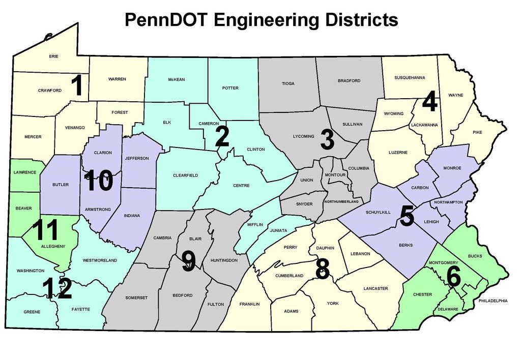
33 HIGHWAY STATISTICS MILEAGE AND TRAVEL PENNDOT ENGINEERING DISTRICTS 30

34 2011 HIGHWAY STATISTICS MILEAGE AND TRAVEL PENNDOT ENGINEERING DISTRICTS 31
35 HIGHWAY STATISTICS FUNCTIONAL CLASSIFICATION Interstate System The Interstate System consists of all presently designated freeway routes meeting the Interstate geometric and construction standards for future traffic. The Interstate System is the highest classification of arterial roads and streets and provides the highest level of mobility, at the highest speed, for a long uninterrupted distance. (Maintenance Functional Class A ) Other Arterials These consist of limited access freeways, multi-lane highways, and other important highways supplementing the Interstate System that connect, as directly as practicable, the Nation s principal urbanized areas, cities, and industrial centers; serve the national defense; and connect at suitable border points with routes of continental importance. (Maintenance Functional Class B and C ) Collectors The collectors provide both land access service and traffic circulation within residential neighborhoods, commercial and industrial areas, and downtown city centers. Collectors connect local roads and streets with arterials and provide less mobility than arterials at lower speeds and for a shorter distance. (Maintenance Functional Class D ) Locals The local roads and streets provide a high level of access to abutting land but limited mobility. (Maintenance Functional Class E ) 32
36 2011 HIGHWAY STATISTICS GLOSSARY AADT (Annual Average Daily Traffic) Typical daily traffic on a road segment for all days in the week, over a one year period. Mean AADT The weighted average of AADTs for all segments of the road. DVMT Daily Vehicle Miles of Travel; a measure of total travel, by all vehicles. Federal Aid System Roads eligible for federal-aid-highway funds; determined by functional classification. Heavy Trucks Trucks with 5 or more axles. Lane Miles Aggregate of miles times number of lanes. 12 Equivalent Lane Miles Total pavement width is divided by 12 to yield the number of equivalent 12 lanes. Linear Miles Length measured along roadway centerline. Maintenance Functional Class - Maintenance Functional Class is based on the federal functional class shown on page 32. National Highway System (NHS) The NHS is comprised of principal arterial and Interstate routes, serving major population centers and intermodal transportation facilities. Other Agencies Includes other state and federal agencies such as State Universities, Department of Conservation and Natural Resources, Department of Health, Department of Education, National Parks & US Forest Service. Rural The area outside the boundaries of small urban & urbanized areas. Small Urban Places having a population of 5,000 or more, not in an urbanized area. Toll Bridges Delaware River toll bridges operated by Delaware River Joint Toll Bridge Commission, Delaware River Port Authority & Burlington County Bridge Commission. Turnpike Toll roads operated by the PA Turnpike Commission. Urban Urban places of 5,000 or more population and urbanized areas as designated by the Bureau of the Census. 33
37 HIGHWAY STATISTICS CUSTOMER SERVICE INFORMATION National Highway System Maps: State, district and county maps available from Joni Sharp, Telephone: (717) or Functional Class Maps: State, district and county maps available from Joni Sharp, Telephone: (717) or Traffic Volume Maps: Statewide and selected county maps available from Jeremy Freeland, Telephone: (717) or Highway and Truck Traffic Data: Available from Jeremy Freeland, Telephone: (717) or All the above information is also available by writing to: Pennsylvania Department of Transportation P.O. Box 3555 Harrisburg, Pennsylvania Fax Number: (717) PennDOT Home Page Address: For more information, visit us through the Pennsylvania Homepage at or visit PennDOT directly at 34
38

39 In cooperation with
CHAPTER 7 CIRCULATION
 CHAPTER 7 CIRCULATION A township s transportation network links its population with the surrounding communities. Transportation networks, including public and private, provide the means by which township
Policy Number: Effective: 07/11/14 Responsible Division: Planning Date: 07/11/2014 FUNCTIONAL CLASSIFICATION AMENDMENT POLICY
 Policy Number: 2014-025 Effective: 07/11/14 Responsible Division: Planning Date: 07/11/2014 FUNCTIONAL CLASSIFICATION AMENDMENT POLICY POLICY STATEMENT: The Northeast Ohio Areawide Coordinating Agency
Chapter 5 FUNCTIONAL CLASSIFICATION
 Chapter 5 FUNCTIONAL CLASSIFICATION Functional classification is a system by which streets and roadways may be distinguished by types according to their function within the entire transportation network.
Functional Classification of Roads and Streets
 Functional Classification of Roads and Streets J o h n E. B a e r w a ld Professor of Transportation and Traffic Engineering Director, Highway Traffic Safety Center University of Illinois, Urbana-Champaign
MASTER THOROUGHFARE PLAN
 MASTER THOROUGHFARE PLAN Master Thoroughfare Plan Update November 2015 Prepared for Town of Northlake AVO 30659 11/11/2015 1201 North Bowser Road Richardson, Texas 75081 Firm Registration No. 312 MASTER
Street Paving and Sidewalk Policy
 City Commission Policy 600 Street Paving and Sidewalk Policy DEPARTMENT: Public Works DATE ADOPTED: June 7, 1995 DATE OF LAST REVISION: December 10, 2014 Policy No. 600.01 AUTHORITY: PASS City of Tallahassee-Leon
City of Wayzata Comprehensive Plan 2030 Transportation Chapter: Appendix A
 A1. Functional Classification Table A-1 illustrates the Metropolitan Council s detailed criteria established for the functional classification of roadways within the Twin Cities Metropolitan Area. Table
2016 ANNUAL TRAFFIC REPORT
 2016 ANNUAL TRAFFIC REPORT Published by Traffic Information Division NEVADA DEPARTMENT OF TRANSPORTATION www.nevadadot.com Brian Sandoval, Governor Rudy Malfabon, P.E., Director The Annual Traffic Report
City of Homewood Transportation Plan
 City of Homewood Transportation Plan Prepared for: City of Homewood, Alabama Prepared by: Skipper Consulting, Inc. May 2007 TABLE OF CONTENTS INTRODUCTION... 1 BACKGROUND INFORMATION... 1 EXISTING TRANSPORTATION
SECTION 1 - TRAFFIC PLANNING
 SECTION 1 - TRAFFIC PLANNING 1.1 TRAFFIC OPERATIONS 1.1.1 Roadway Functional Classification The Multnomah County Comprehensive Framework Plan s Policy 34: Trafficways and the Functional Classification
Traffic Accident Data Processing
 Traffic Accident Data Processing D o n a l d F. P e t t y Engineer of Traffic Research and Surveys Indiana State Highway Commission The following is a portion of the Highway Safety Program Standards developed
Act 47 Exception Application Process (Permitting Bicycle Travel on Freeways)
") Act 47 Exception Application Process (Permitting Bicycle Travel on Freeways) Attached is a revised application process to permit Pedalcycle travel on the shoulders of freeways within the Commonwealth.
Act 47 Exception Application Process (Permitting Bicycle Travel on Freeways) Attached is a revised application process to permit Pedalcycle travel on the shoulders of freeways within the Commonwealth.
Congestion Management Report
 Congestion Management Report NH 101A (Amherst St and Canal/Bridge St), NASHUA Segment Length: 2.7 miles Daily Traffic Volumes: 9,000-40,000 Analysis Period: August 2015 Number of Traffic Signals: 9 Number
Appendix B Existing ADOT Data Parameters
 Appendix B Existing ADOT Data Parameters Appendix 08/04/03 HPMS by Item Number All records 1 Year of Submittal 2 State Code 3 English or Metric Reporting Units 4 County Code 5 Section Identification (ID)
Guidelines for Integrating Safety and Cost-Effectiveness into Resurfacing, Restoration, and Rehabilitation Projects
 Guidelines for Integrating Safety and Cost-Effectiveness into Resurfacing, Restoration, and Rehabilitation Projects NCHRP Project 15-50 July 2017 1 Research Objective Develop guidelines for safe and cost-effective
MCTC 2018 RTP SCS and Madera County RIFP Multi-Modal Project Eval Criteria GV13.xlsx
 MCTC 8 RTP SCS and Madera County RIFP Multi-Modal Project Eval Criteria GV.xlsx Madera County Transportation Commission Regional Transportation Plan / Sustainable Communities Strategy Multi-Modal Project
Geometric Design Tables
 Design Manual Chapter 5 - Roadway Design 5C - Geometric Design Criteria 5C-1 Geometric Design Tables A. General The following sections present two sets of design criteria tables - Preferred Roadway Elements
2002 Virginia Department of Transportation Daily Traffic Volume Estimates. Special Locality Report 209
 2002 Daily Traffic Volume Estimates Special Locality Report 209 Prepared By Mobility Management Division In Cooperation With U.S. Department of Transportation Federal Highway Administration Mobility Management
2002 Virginia Department of Transportation Daily Traffic Volume Estimates Including Vehicle Classification Estimates. Special Locality Report 261
 2002 Daily Traffic Volume Estimates Including Vehicle Classification Estimates where available Special Locality Report 261 Prepared By In Cooperation With U.S. Department of Transportation Federal Highway
INTRODUCTION THOROUGHFARE SYSTEM CLASSIFICATIONS
 INTRODUCTION The thoroughfare plan will assist public officials in the development of a specialized system for efficient and safe movement of vehicular traffic while minimizing potential conflicts with
2016 Virginia Department of Transportation Daily Traffic Volume Estimates Including Vehicle Classification Estimates
 2016 Virginia Department of Transportation Daily Traffic Volume Estimates Including Vehicle Classification Estimates where available Jurisdiction Report TOL Other Toll Prepared By Virginia Department of
Fairfax County Transportation Funding and Roadway Service Delivery Study. Study Update Transportation Advisory Commission
 Fairfax County Transportation Funding and Roadway Service Delivery Study Study Update Transportation Advisory Commission May 4, 2010 Past Studies Aug. 1965 The Financial Effects of the Incorporation of
APPENDIX A TWO-LANE RURAL ROADS ELEMENTS OF DESIGN CREST VERTICAL CURVES
 APPENDIX A TWO-LANE RURAL ROADS ELEMENTS OF DESIGN CREST VERTICAL CURVES 1. Two-lane Rural Roads 1.1 Introduction The definition of rural area can be derived from the definition of urban areas. Officially,
ADOT Statewide Bicycle and Pedestrian Program Summary of Phase IV Activities APPENDIX B PEDESTRIAN DEMAND INDEX
 ADOT Statewide Bicycle and Pedestrian Program Summary of Activities APPENDIX B PEDESTRIAN DEMAND INDEX May 24, 2009 Pedestrian Demand Index for State Highway Facilities Revised: May 29, 2007 Introduction
Brian D. Hare, P.E. Bureau of Design PennDOT PA APA Annual Conference Investing in a Sustainable Future October 5, 2009
 Brian D. Hare, P.E. Bureau of Design PennDOT 2009 PA APA Annual Conference Investing in a Sustainable Future October 5, 2009 1 What is Smart Transportation? Photographer: heyjude. Used through license
US287 Asset Inventory Fort Collins. Figure 5-1 Fort Collins Bridges and Traffic Signals
 Chapter 5: City of Fort Collins US287 through Fort Collins is known as College Avenue, runs for approximately 9.25 miles, and bisects the City north to south. Within the City, US287 is a principal arterial.
ANNUAL VEHICLE MILES OF TRAVEL
 NEVADA DEPARTMENT OF TRANSPORTATION AVMT AVMT AVMT AVMT AVMT AVMT AVMT ANNUAL VEHICLE MILES OF TRAVEL In Cooperation with U.S. Department of Transportation Federal Highway Administration, Nevada Division
Classification Criteria
 SCHEDULE D TO RECOMMENDED OFFICIAL PLAN AMENDMENT NO. 40 SCHEDULE C-4 Road Criteria Criteria Traffic Service Objective Land Service/Access Typical Daily Traffic Volume Flow characteristics Travel Speed
2010 Virginia Department of Transportation Daily Traffic Volume Estimates Including Vehicle Classification Estimates. Special Locality Report 172
 2010 Daily Traffic Volume Estimates Including Vehicle Classification Estimates where available Special Locality Report 172 Town of Boyce Information in this report is included in Report (Clarke County)
2005 Virginia Department of Transportation Daily Traffic Volume Estimates Including Vehicle Classification Estimates. Special Locality Report 324
 2005 Virginia Department of Transportation Daily Traffic Volume Estimates Including Vehicle Classification Estimates where available Special Locality Report 324 Prepared By Virginia Department of Transportation
PENNDOT HPMS DATA COLLECTION GUIDE. Bureau of Planning and Research Transportation Planning Division April 2016 (Updated March 2018)
") PENNDOT HPMS DATA COLLECTION GUIDE Bureau of Planning and Research April 2016 (Updated March 2018) State Street Dauphin County NOTES INTRODUCTION The purpose of this document is to provide you with some
PENNDOT HPMS DATA COLLECTION GUIDE Bureau of Planning and Research April 2016 (Updated March 2018) State Street Dauphin County NOTES INTRODUCTION The purpose of this document is to provide you with some
Appendix A. Functional Classification
 Appendix A Functional Classification 1 Functional Classification Roadways serve two primary functions providing access to land uses, and providing mobility to travelers. The functional classification of
Pavement Markings (1 of 3)
") Pavement Markings (1 of 3) DESCRIPTION AND DEFINITION Disadvantages Relatively high cost (over typical Crash reduction as yet unknown painted edge line) No tactile effect The STOP AHEAD pavement marking
Pavement Markings (1 of 3) DESCRIPTION AND DEFINITION Disadvantages Relatively high cost (over typical Crash reduction as yet unknown painted edge line) No tactile effect The STOP AHEAD pavement marking
2016 Virginia Department of Transportation Daily Traffic Volume Estimates Including Vehicle Classification Estimates
 2016 Virginia Department of Transportation Daily Traffic Volume Estimates Including Vehicle Classification Estimates where available Jurisdiction Report WV West Virginia repared By Virginia Department
PENNDOT HPMS DATA COLLECTION GUIDE
 PENNDOT HPMS DATA COLLECTION GUIDE Bureau of Planning and Research April 2016 (Updated September 2017) State Street Dauphin County INTRODUCTION The purpose of this document is to provide you with some
2002 Virginia Department of Transportation Daily Traffic Volume Estimates. Special Locality Report 146
 Virginia Department of Transportation Daily Traffic Volume Estimates Special Locality Report 146 Prepared By Virginia Department of Transportation Mobility Management Division In Cooperation With U.S.
2015 Virginia Department of Transportation Daily Traffic Volume Estimates Including Vehicle Classification Estimates
 2015 Virginia Department of Transportation Daily Traffic Volume Estimates Including Vehicle Classification Estimates where available Special Locality Report 184 Information in this report is included in
Madison Urban Area and Dane County. Bicycle Transportation Plan Summary. September Introduction. Bicycle Plan Scope and Planning Process
 Bicycle Transportation Plan Summary Madison Urban Area and Dane County Introduction September 2000 Bicycling is an important mode of transportation in the Madison urban area and countywide that is available
Highway & Traffic Engineering. Road Classification and Design Standard in Malaysia
 For updated version, please click on http://ocw.ump.edu.my Highway & Traffic Engineering Road Classification and Design Standard in Malaysia by Pn. Azlina binti Ismail and Dr.Intan Suhana binti Mohd Razelan
2003 Virginia Department of Transportation Daily Traffic Volume Estimates. Special Locality Report 198
 2003 Virginia Department of Transportation Daily Traffic Volume Estimates Special Locality Report 198 Prepared By Virginia Department of Transportation Mobility Management Division In Cooperation With
CITY OF LUCAS 2014 MASTER THOROUGHFARE PLAN
 INTRODUCTION CITY OF LUCAS 2014 MASTER THOROUGHFARE PLAN A thoroughfare system is intended to provide an effective means of moving vehicles within and through a city. The thoroughfare plan will assist
WYDOT DESIGN GUIDES. Guide for. NHS Arterial (Non-Interstate)
") WYDOT DESIGN GUIDES Guide for NHS Arterial (Non-Interstate) 2014 GUIDE FOR NATIONAL HIGHWAY SYSTEM (NHS) HIGHWAYS (NHS ARTERIALS, Non-Interstate) PRESERVATION REHABILITATION RECONSTRUCTION INTRODUCTION
WYDOT DESIGN GUIDES Guide for NHS Arterial (Non-Interstate) 2014 GUIDE FOR NATIONAL HIGHWAY SYSTEM (NHS) HIGHWAYS (NHS ARTERIALS, Non-Interstate) PRESERVATION REHABILITATION RECONSTRUCTION INTRODUCTION
Mobility and Congestion
 Technical Memorandum Mobility and Congestion Prepared for: Prepared by: September 25, 2013 1 Table of Contents 1. Introduction... 1 2. Congestion Forecasting Process... 1 2.1 Mobility and Congestion Terms...
US287 Asset Inventory Loveland. Figure 6-1 Loveland Bridges and Traffic Signals
 Chapter 6: City of Loveland US287 extends for approximately 13.1 miles through the City of Loveland. Between the northern City boundary and 29 th Street, the road is labeled Garfield Avenue, before transitioning
Vision Zero High Injury Network Methodology
 Vision Zero High Injury Network Methodology DATA SETS USED: 1. Reportable crashes in Philadelphia from 2012-2016, available as open data through PennDOT 2. Street Centerline geographic layer, maintained
Transportation Impact Study for Abington Terrace
 Transportation Impact Study for Abington Terrace Abington Township, Montgomery County, PA Sandy A. Koza, P.E., PTOE PA PE License Number PE059911 Prepared by McMahon Associates, Inc. 425 Commerce Drive,
General Interest Highway Statistics Source Book
 General Interest Highway Statistics Source Book 2016 PRODUCED BY Florida Department of Transportation Transportation Statistics Office Contents Introduction 1 Public Road Mileage Summaries 1 Online Access
Basalt Creek Transportation Refinement Plan Recommendations
 Basalt Creek Transportation Refinement Plan Recommendations Introduction The Basalt Creek transportation planning effort analyzed future transportation conditions and evaluated alternative strategies for
Appendix C. Corridor Spacing Research
 Appendix C. Corridor Spacing Research Task 3 of the Twin Cities Bicycle Study called for the development of bicycle corridor spacing guidelines. This section summarizes research of the spacing of planned
Maine Highway Safety Facts 2016
 Maine Highway Safety Facts 216 216 MAINE HIGHWAY SAFETY FACTS The Bureau of Highway Safety and the Maine Department of Transportation are pleased to present the 216 edition of Maine Highway Safety Facts.
2015 Virginia Department of Transportation Daily Traffic Volume Estimates Including Vehicle Classification Estimates
 2015 Virginia Department of Transportation Daily Traffic Volume Estimates Including Vehicle Classification Estimates where available Special Locality Report 161 Information in this report is included in
T A B L E OF C O N T E N T S
 T A B L E OF C O N T E N T S PART III SUBDIVISION REGULATIONS OF THE DEPARTMENT OF PUBLIC WORKS, C & C D PAGE PAGE Responsibility for Development of Streets......... 29 Right-of-Way Widths...... 37 Purpose...........
APPENDIX M FOR THE JEFFERSON COUNTY PORTION OF THE VISION 2050 PLAN RECOMMENDATIONS MILWAUKEE URBANIZED AREA INTRODUCTION
 INTRODUCTION Following the 2010 U.S. Census, 70 the Milwaukee urbanized area boundary extends beyond the Southeastern Wisconsin Region across the boundary line between Waukesha and Jefferson Counties,
2017 Virginia Department of Transportation Daily Traffic Volume Estimates Including Vehicle Classification Estimates
 2017 Virginia Department of Transportation Daily Traffic Volume Estimates Including Vehicle Classification Estimates where available Special Locality Report 200 Town of Columbia Information in this report
Appendix 3 Roadway and Bike/Ped Design Standards
 Appendix 3 Roadway and Bike/Ped Design Standards OTO Transportation Plan 2040 4/20/2017 Page A3-1 Adopted Standards The adopted OTO Design Standards and Major Thoroughfare Plan are contained herein.
This Chapter sets forth the minimum design, technical criteria and specifications to be used in the preparation of all roadway plans.
 4.1 GENERAL This Chapter sets forth the minimum design, technical criteria and specifications to be used in the preparation of all roadway plans. These Roadway Standards are for new construction and modification
Congestion Management Report
 Congestion Management Report F.E. EVERETT TURNPIKE (NORTH), MERRIMACK Segment Length: 7.0 miles Daily Traffic Volumes: 60,000-69,000 Analysis Period: May 2015 Number of Traffic Signals: 0 Number of travel
o n - m o t o r i z e d transportation is an overlooked element that can greatly enhance the overall quality of life for the community s residents.
 N o n - m o t o r i z e d transportation is an overlooked element that can greatly enhance the overall quality of life for the community s residents. 84 Transportation CHAPTER 11 INTRODUCTION Transportation
Abstract. Background. protected/permissive operation. Source: Google Streetview, Fairview/Orchard intersection
 ITE 2015 Western District Annual Meeting Ada County Highway District s Flashing Yellow Arrow Initiative Primary Author: Tim Curns, PE Ada County Highway District Traffic Engineer Author: Andrew Cibor,
Clackamas County Comprehensive Plan
 ROADWAYS The County s road system permits the movement of goods and people between communities and regions, using any of a variety of modes of travel. Roads provide access to virtually all property. They
Appendix T-2: Transportation Facilities Inventory
 Appendix T-2: Transportation Facilities Inventory Roads, Highways and Bridges The Georgia Department of Transportation (GDOT) maintains centerline mile measures for all counties in Georgia based on functional
appendix b BLOS: Bicycle Level of Service B.1 Background B.2 Bicycle Level of Service Model Winston-Salem Urban Area
 appendix b BLOS: B.1 Background Winston-Salem Urban Area Bicycle Level of Service Level of Service (LOS) is a framework that transportation professionals use to describe existing conditions (or suitability)
1.3.4 CHARACTERISTICS OF CLASSIFICATIONS
 Geometric Design Guide for Canadian Roads 1.3.4 CHARACTERISTICS OF CLASSIFICATIONS The principal characteristics of each of the six groups of road classifications are described by the following figure
FINAL DESIGN TRAFFIC TECHNICAL MEMORANDUM
 FINAL DESIGN TRAFFIC TECHNICAL MEMORANDUM July 2014 FINAL (SR 43) Project Development and Environment Study From State Road 60 (Adamo Drive) to I-4 (SR 400) Hillsborough County, Florida Work Program Item
Driveway Design Criteria
 Design Manual Chapter 5 - Roadway Design 5L - Access Management 5L-4 Driveway Design Criteria A. General For efficient and safe operations, access drives and minor public street intersections can be improved
Table of Contents Kansas Highway Safety Improvement Program
 KANSAS Page 1 of 54 Table of Contents Table of Contents... 2 Disclaimer... 3 Executive Summary... 4 Introduction... 5 Program Structure... 5 Program Administration... 5 Program Methodology... 8 Project
Phone: Fax: Project Reference No. (to be filled out by MassHighway):
:") Massachusetts Highway Department District 3 Project Need Form (PNF) This form is intended to provide preliminary information about the proposed project. It is not expected that all information that is
Massachusetts Highway Department District 3 Project Need Form (PNF) This form is intended to provide preliminary information about the proposed project. It is not expected that all information that is
Burlington County Bicycle Level of Service Study
 Burlington County Bicycle Level of Service Study June 2013 The Delaware Valley Regional Planning Commission is dedicated to uniting the region s elected officials, planning professionals, and the public
Development of Criteria to Identify Pedestrian High Crash Locations in Nevada. Quarterly Progress Report. Submitted to
 Development of Criteria to Identify Pedestrian High Crash Locations in Nevada Submitted to Nevada Department of Transportation (NDOT) Research Division 1263 South Stewart Street Carson City, NV 89712 Krishna
Performance Measures Target Setting NCTCOG Public Meetings
 Performance Measures Target Setting NCTCOG Public Meetings October 8,15,18, 2018 Performance-Based Planning Mobility 2045 Regional Goals Performance Measures Measure System Performance and Report Progress
Safety Corridors a Synthesis. Charlie Nemmers / Derek Vap University of Missouri
 Safety Corridors a Synthesis Charlie Nemmers / Derek Vap University of Missouri 1 Background: Safety Corridors Study Need grew from a four State Safety Summit Funding from Iowa, Kansas, Missouri DOTs and
WYDOT DESIGN GUIDES. Guide for. Non-NHS State Highways
 WYDOT DESIGN GUIDES Guide for Non-NHS State Highways 2014 GUIDE FOR Non-NATIONAL HIGHWAY SYSTEM (Non-NHS) STATE HIGHWAYS PRESERVATION REHABILITATION RECONSTRUCTION INTRODUCTION This Guide is directed to
2009 Virginia Department of Transportation Daily Traffic Volume Estimates Including Vehicle Classification Estimates. Special Locality Report 250
 2009 Virginia Department of Transportation Daily Traffic Volume Estimates Including Vehicle Classification Estimates where available Special Locality Report 250 Information in this report is included in
3 ROADWAYS 3.1 CMS ROADWAY NETWORK 3.2 TRAVEL-TIME-BASED PERFORMANCE MEASURES Roadway Travel Time Measures
 ROADWAYS Approximately 6 million trips are made in the Boston metropolitan region every day. The vast majority of these trips (80 to percent, depending on trip type) involve the use of the roadway network
2002 Virginia Department of Transportation Daily Traffic Volume Estimates. Special Locality Report 204
 Virginia Department of Transportation Daily Traffic Volume Estimates Special Locality Report 204 Prepared By Virginia Department of Transportation Mobility Management Division In Cooperation With U.S.
Identification of Hazardous Locations on City Streets
 Transportation Kentucky Transportation Center Research Report University of Kentucky Year 1977 Identification of Hazardous Locations on City Streets Charles V. Zegeer Robert C. Deen Kentucky Department
Appendix PIT Pittsburgh, Pennsylvania 2003 Annual Report on Freeway Mobility and Reliability
 (http://mobility.tamu.edu/mmp) Office of Operations, Federal Highway Administration Appendix PIT Pittsburgh, Pennsylvania 2003 Annual Report on Freeway Mobility and Reliability This report is a supplement
Appendix B MoDOT Access Management Guidelines
 Appendix B MoDOT Access Management Guidelines Meramec Regional Transportation Plan Page B-1 MISSOURI DEPARTMENT OF TRANSPORTATION ACCESS MANAGEMENT GUIDELINES September 12, 2003 Meramec Regional Transportation
Gordon Proctor Director Policy on Accommodating Bicycle and Pedestrian Travel on ODOT Owned or Maintained Facilities
 Approved: Policy: 20-004(P) Responsible Office: Planning Gordon Proctor Director Policy on Accommodating Bicycle and Pedestrian Travel on ODOT Owned or Maintained Facilities I. POLICY STATEMENT: This policy
TRASBURG RANSPORTATION
 TRASBURG RANSPORTATION LAN DEVELOPED BY THE TRANSPORTATION PLANNING DIVISION OF THE VIRGINIA DEPARTMENT OF TRANSPORTATION IN COOPERATION WITH THE U.S. DEPARTMENT OF TRANSPORTATION, FEDERAL HIGHWAY ADMINISTRATION
Chapter 6 Transportation Plan
 Chapter 6 Transportation Plan Transportation Plan Introduction Chapter 6 Transportation Plan Transportation Plan Introduction This chapter describes the components of Arvada s transportation system, comprised
Traffic Congestion in Houston. Presented by Bill King
 Traffic Congestion in Houston Presented by Bill King www.billkinghouston.com The Travel Time Index Defined 1.36 30 Minute Trip = 41 Minute Trip (+ 36%) The History of Congestion in Houston Growing Congestion
THE I-79 CORRIDOR. I-79 provides motorists with connections to the following major highways: I-80, PA 358, PA 965 and PA 208.
 The I-79 Corridor Pittsburgh to Erie Regional Thruway I-79 was constructed through Mercer County in the early 1960s. The portion north of PA 965 opened in 1961 and the segment south of PA 965 the following
Congestion Management Report
 Congestion Management Report DANIEL WEBSTER HIGHWAY, MERRIMACK Segment Length: 9.9 miles Daily Traffic Volumes: 13,000-21,000 Analysis Period: July August 2015 Number of Traffic Signals: 14 Number of travel
TRAFFIC IMPACT ANALYSIS
 TRAFFIC IMPACT ANALYSIS FOR THE CHAMPAIGN UNIT#4 SCHOOL DISTRICT PROPOSED HIGH SCHOOL (SPALDING PARK SITE) IN THE CITY OF CHAMPAIGN Final Report Champaign Urbana Urbanized Area Transportation Study 6/24/2014
RURAL HIGHWAY SHOULDERS THAT ACCOMMODATE BICYCLE AND PEDESTRIAN USE (TxDOT Project ) June 7, Presented by: Karen Dixon, Ph.D., P.E.
 June 7, Presented by: Karen Dixon, Ph.D., P.E.") RURAL HIGHWAY SHOULDERS THAT ACCOMMODATE BICYCLE AND PEDESTRIAN USE (TxDOT Project 0-6840) June 7, 2016 Presented by: Karen Dixon, Ph.D., P.E., TTI Team: Kay Fitzpatrick, Raul Avelar, & Subasish Das Project
RURAL HIGHWAY SHOULDERS THAT ACCOMMODATE BICYCLE AND PEDESTRIAN USE (TxDOT Project 0-6840) June 7, 2016 Presented by: Karen Dixon, Ph.D., P.E., TTI Team: Kay Fitzpatrick, Raul Avelar, & Subasish Das Project
Regional Bicycle Barriers Study
 Regional Bicycle Barriers Study Executive Summary Background and Purpose The 2040 Transportation Policy Plan (TPP) sets policies for planning and investment direction in the transportation system in the
TRANSPORTATION & MOBILITY
 TRANSPORTATION & MOBILITY ROADWAY SYSTEM There are approximately 40 miles of roadways in Manitou Springs. For planning purposes, roadways are typically assigned a functional classification which defines
Twin Cities Bicycle Barriers Study Technical Advisory Work Group December 19, 2016
 Twin Cities Bicycle Barriers Study Technical Advisory Work Group December 19, 2016 Regional Bicycle Barriers Overall Study Area Parameters Specific Barrier Parameters Rivers & streams Rail corridors Overall
ARTINSVILLE ENRY OUNTY REA RANSPORTATION TUDY
 ARTINSVILLE ENRY OUNTY REA RANSPORTATION TUDY DEVELOPED BY THE TRANSPORTATION AND MOBILITY PLANNING DIVISION OF THE VIRGINIA DEPARTMENT OF TRANSPORTATION IN COOPERATION WITH THE U.S. DEPARTMENT OF TRANSPORTATION,
Secondary Road Program
 Secondary Road Program Joint Legislative Transportation Oversight Committee October 5, 2012 1 Secondary Roads Program The Big Picture The Secondary Road System Needs and Project Types Paved and Unpaved
City of Hanover TRANSPORTATION STUDY
 City of Hanover TRANSPORTATION STUDY AUGUST 2006 Prepared by: WSB & Associates, Inc. 701 Xenia Avenue South, Suite 300 Minneapolis, MN 55416 (763) 541-4800 (763) 541-1700 (Fax) City of Hanover Transportation
Chapter 4 Traffic Analysis
 Chapter 4 Traffic Analysis PURPOSE The traffic analysis component of the K-68 Corridor Management Plan incorporates information on the existing transportation network, such as traffic volumes and intersection
2014 Virginia Department of Transportation Daily Traffic Volume Estimates Including Vehicle Classification Estimates
 Daily Traffic Volume Estimates Including Vehicle Classification Estimates where available Special Locality Report 271 Information in this report is included in Report (Scott County) Prepared By In Cooperation
CHAPTER 1 GENERAL DESIGN
 CHAPTER 1 GENERAL DESIGN 1.0 INTRODUCTION The purpose of this Manual is to provide its users with the current, uniform procedures and guidelines for the application and design of safe, convenient, efficient
CITY OF COCONUT CREEK IMPLEMENTATION GUIDELINES FOR TRAFFIC CALMING
 CITY OF COCONUT CREEK IMPLEMENTATION GUIDELINES FOR TRAFFIC CALMING I. Introduction: The City of Coconut Creek recognizes that the conditions of residential streets can greatly affect neighborhood livability;
2010 Virginia Department of Transportation Daily Traffic Volume Estimates Including Vehicle Classification Estimates. Special Locality Report 331
 2010 Daily Traffic Volume Estimates Including Vehicle Classification Estimates where available Special Locality Report 331 Information in this report is included in Report (Pittsylvania County) Prepared
Dr. Naveed Anwar Executive Director, AIT Consulting Affiliated Faculty, Structural Engineering Director, ACECOMS
 Dr. Naveed Anwar Executive Director, AIT Consulting Affiliated Faculty, Structural Engineering Director, ACECOMS Overview Highway Functions and Classifications Highway Design Components Design Control
2015 Virginia Department of Transportation Daily Traffic Volume Estimates Including Vehicle Classification Estimates
 2015 Daily Traffic Volume Estimates Including Vehicle Classification Estimates where available Special Locality Report 174 Information in this report is included in Report (Southampton County) Prepared
2002 Virginia Department of Transportation Daily Traffic Volume Estimates. Special Locality Report 153
 Virginia Department of Transportation Daily Traffic Volume Estimates Special Locality Report 153 Prepared By Virginia Department of Transportation Mobility Management Division In Cooperation With U.S.