SKANEATELES MULTI-USE CORRIDOR STUDY
|
|
|
- Joleen Oliver
- 5 years ago
- Views:
Transcription

1 February 2018 SHARE THE ROAD SHARE THE ROAD SHARE THE ROAD DRAFT HARE SKANEATELES MULTI-USE CORRIDOR STUDY

2 Skaneateles Multi-Use Corridor Study Syracuse Metropolitan Transportation Council DRAFT Report February 14, 2018 This document was prepared with financial assistance from the Federal Highway Administration and the Federal Transit Administration of the U.S. Department of Transportation through the New York State Department of Transportation. The Syracuse Metropolitan Transportation Council is solely responsible for its contents. For further information contact: Michael D. Alexander, AICP, Project Manager James D Agostino, Director Syracuse Metropolitan Transportation Council 126 N. Salina St., 100 Clinton Square, Suite 100, Syracuse, NY PHONE: (315) FAX: (315)
3 EXECUTIVE SUMMARY DRAFT - Skaneateles Multi-Use Corridor Study Skaneateles Multi-Use Corridor Study The Skaneateles Multi-Use Corridor Study (study) is a planning-level assessment that informs local residents, business owners, and community leaders about potentially feasible options for bicycle and pedestrian amenities along Fennell Street from the Charlie Major Trail to Jordan Street. It is not a proposal to build or construct, but instead identifies some improvement options for future consideration by the community. Potential improvements are based on a comprehensive planning-level assessment, which involved participation and oversight by the owners of the roadways (i.e., Onondaga County Department of Transportation, Town of Skaneateles, Village of Skaneateles, and the New York State Department of Transportation). This planning process ensured that the ideas were well-vetted with the roadway owners and that further consideration is possible if the local community expresses an interest. Some of the identified options are more complex than others and may require additional study, engineering design, public review, and environmental assessment. Technical Planning Assistance Transportation planners from the Syracuse Metropolitan Transportation Council (SMTC) provided planning services at no cost to the local community. This document was prepared using federal transportation funds that are designated for planning activities only (not construction). The SMTC does not own or control any infrastructure. The village, town, county, and state own different roadways within the study area. Any future improvements would require additional coordination and agreement with the respective road owner. Purpose The purpose of this study is to identify planning-level options for on-road and offroad bicycle and pedestrian amenities along Fennell Street between the Charlie Major Trail to Jordan Street. Study Advisory Committee To oversee this study s development, the SMTC established a Study Advisory Committee (SAC) composed of representatives from the village, town, county, and state. Study Area As shown in the following page, the study area is generally bounded by Seneca Turnpike to the north, Route 20 to the south, Skaneateles Creek to the west, and Jordan Road to the east. Existing Plans The SMTC reviewed and summarized existing community plans and found that they support on- road and off-road bicycle and pedestrian amenities improvements within the study area. i

4 EXECUTIVE SUMMARY DRAFT - Skaneateles Multi-Use Corridor Study ii
5 EXECUTIVE SUMMARY DRAFT - Skaneateles Multi-Use Corridor Study Existing Conditions Assessment To help identify the types of bicycle and walking amenities that best meet the community s needs, the SMTC assessed the community s demographics, land use patterns, environmental constraints (for the off-road trail options), and physical roadway characteristics and conditions. Focus Areas Community leaders indicated that people do not like to walk or bike across the following two study area intersections: Old Seneca Turnpike at Fennell Street Fennell Street at Jordan Street. Some community leaders also wondered if the Charlie Major Trail could be extended south to the village. Planners focused on these areas to identify what options exist to add (or improve) on-road and off-road bicycle and pedestrian amenities. Intersection - Old Seneca Turnpike/Fennell Street/Mill Road Option 1 - Potential on-road bicycle and pedestrian amenities: Considers options for shoulders, narrowing the intersection crossing width, crosswalks, shared lane pavement markings for bicyclists, bicycle and pedestrian signs, button-activated LED bike/pedestrian crossing warning signs across the Old Seneca Turnpike, and street lights. Option 2 Potential off-road bicycle and pedestrian amenities: Considers options for a shared use trail along Skaneateles Creek from the Charlie Major Trail to the village boundary. Multi-use crosswalks are considered as well as other improvements such as bicycle and pedestrian signs, narrowing the intersection crossing width, buttonactivated LED bike/pedestrian crossing warning signs across the Old Seneca Turnpike, and street lights. Intersection Fennell Street/Jordan Street Option 1 Bike Lane Concept Maintain On-Street Parking: Considers options for bike lanes within the Fennell Street business district and shared lane markings along Jordan Street. It also considers narrowing the Fennell Street intersection and identifies potential crosswalk options. Option 2 Bike Lane Concept with additional On-Street Parking: This option is the same as Option 1, but it prioritizes adding additional on-street parking along Fennell Street. Pros and cons and trade-offs are identified. Option 3 Roundabout Concept: Considers the pros and cons of a roundabout and shared lane markings. Conclusion The community is welcome to use this report to coordinate with road owners if they are interested in exploring any of the ideas. The SMTC is available as a resource to answer any questions about the planning process and help coordinate with its member agencies if necessary. iii
6 Table of Contents 1 - Introduction Overview Study Purpose and Objectives Background Study Advisory Committee Public Involvement Plan Study Area Local Planning Studies and Initiatives Fennell Street Commercial Corridor Master Plan, March Skaneateles, New York Joint Comprehensive Plan 2015 (with October 31, 2016 revisions) Town of Skaneateles Open Space Plan (October 2016) SMTC Pedestrian Demand Model Existing Conditions Demographics Study Area Land Use Environmental Resources Accident Assessment Physical Conditions Bicycle and Pedestrian Amenity Options Focus Areas Intersection - Old Seneca Turnpike/Fennell Street/Mill Road Existing Conditions Option 1 - Potential On-road Bicycle and Pedestrian Amenities Option 2 - Potential Off-road Bicycle and Pedestrian Amenities Intersection Fennell Street/Jordan Street Existing Conditions Option 1 Bike Lane Concept Maintain On-Street Parking Page 1
7 Option 2 Bike Lane Concept with additional On-Street Parking Option 3 Roundabout Concept Remainder of Study Area Sidewalk and Crosswalk Considerations Accommodate Bicyclists Public Feedback Conclusion List of Figures Figure 1 Study Area Figure 2 Population Density Figure 3 Population by Age Figure 4 Means of Transportation to Work Figure 5 Land Use Map Figure 6 Environmental Resources (Study Area) Figure 7 Potentially Feasible Trail Extension Options Figure 8 Environmental Resources (Off-Road Trail Segments) Figure 9 Steep Slopes Figure 10 Accidents at Intersections Figure 11 Accidents along Roadway Segments Figure 12 Pavement Ratings Figure 13 Roadway Measurements Town Figure 14 Roadway Measurements Village Figure 15 Traffic Volume, Speed Limits, and Roadway Classification Figure 16 Existing Conditions Fennell Street/Mill Road/Old Seneca Turnpike Intersection Figure 17 Option 1: Potential On-Road Bike and Pedestrian Amenities (Fennell/Old Seneca) Figure 18 Option 2: Potential Off-Road Bike and Pedestrian Amenities (Fennell/Old Seneca) Figure 19 Existing Conditions Fennell Street and Jordan Street Intersection Figure 20 Option 1: Bike Lane Concept Maintain On-Street Parking Figure 21 Option 2: Bike Lane Concept with Additional On-Street Parking Figure 22 Option 3: Roundabout Concept with New On-Street Parking Enhancements Figure 23 General Options Appendices Appendix A Public Involvement Plan (PIP) Appendix B Bicycle and Pedestrian Facility Reference Sheet Appendix C Public Comment Summary Page 2
8 1 - Introduction 1.1 Overview As part of the Unified Planning Work Program (UPWP), the Syracuse Metropolitan Transportation Council (SMTC) agreed to complete the Skaneateles Multi-Use Corridor Study (study) for the Skaneateles community. The SMTC serves as an objective, federallymandated planning agency responsible for conducting transportation planning studies within the (Syracuse) Metropolitan Planning Area, or MPA. Although this effort was undertaken at the request of the Town of Skaneateles (Town), the SMTC, as a public planning agency, is not a consultant hired by the town or village to advance a particular outcome. Professional transportation planners from the SMTC provided technical and objective expertise at no cost to the local community. This document was prepared using federal transportation funds (not grants) that are designated specifically for planning activities; these funds cannot be used for construction or other capital improvement expenditures. The SMTC does not own or control any infrastructure. The village, town, county, and state own and control different roadways within the study area. Future improvements within the study area may require coordination and agreement among the respective road owners. What is a corridor study? A corridor study is a planning-level assessment that identifies potentially feasible opportunities to add or improve on-road and off-road bicycle and pedestrian amenities. It is not a proposal to build or construct, but instead identifies bicycle and pedestrian facility options for future consideration by the entire community. The planning process allowed the local community to comment on the potential improvements. Community input helps the road owners (i.e., village, town, county, and state) determine what concepts may be desired within the community. Some of the concepts will require additional study, engineering design, public review, and environmental assessment before a decision can be made. Therefore, the purpose of this planninglevel assessment is to determine what onroad and off-road bicycle and pedestrian amenities may potentially feasible (and which options should be removed from consideration due to impracticability) with the sole intent to help the community decide if there is interest to further study, design, and build these facilities. 1.2 Study Purpose and Objectives The SMTC outlined the following purpose and objectives to guide the study: Page 3
9 Study Purpose: The purpose of this study is to identify planning-level options to add or improve on-road and off-road bicycle and pedestrian amenities along Fennell Street between the Charlie Major Trail to Jordan Street. Study Objectives: Improve access to the Charlie Major Trail from the heart of the village Increase the number of walkers and bicyclists from the village to the Charlie Major Trail Identify low-cost efforts to add/improve on-road and off-road bicycle and pedestrian facilities Support the ability for walkers and bicyclists to travel safely, especially when crossing major roadways, and Support efforts that aim to protect or enhance property values. 1.3 Background In 2014, the Town formed an ad hoc committee the Multi-Use Trail Committee (MUTC) to envision the transformation of the former Skaneateles Short Line Railroad corridor into a multi-use trail from the Village of Skaneateles to the hamlet of Skaneateles Falls. Eighteen months later, the Town requested assistance from the SMTC to help guide a planning process to identify trail options. Subsequently, the SMTC agreed to undertake the study in April Shortly after the SMTC agreed to undertake the study, and prior to its commencement, approximately 50 residents filed a formal petition opposing the trail and Town residents elected a new supervisor. Many of those who opposed the trail concept included property owners directly impacted by the trail s development. (A trail over the former railroad bed would be within a few feet of the front door of several properties.) Those who opposed the trail also expressed concerns that include: safety, maintenance, liability, and impacts to community character. In light of the petition and election of the new supervisor, the SMTC met with the Town (April 2016) to determine if the community still wanted the SMTC to study potential trail options. The Town chose to redirect the study s focus to identify opportunities for on-road and off-road bicycle and pedestrian facility improvements linking the Charlie Major Trail to the heart of the Village of Skaneateles. The SMTC agreed to adjust its work scope if municipal officials from the Village of Skaneateles also agreed to be involved in the planning process. In May 2016, the SMTC met with the Village to discuss their involvement. The Village expressed a willingness to be involved in planning meetings. Village representatives Page 4
10 shared concerns about the lack of public property that could be used for an off-road trail along Skaneateles Creek. As such, the Village requested that only on-road improvements within the right-of-way be considered within their municipality. Considerations for on-road and off-road improvements would occur within the Town of Skaneateles. To guide its planning process, the SMTC developed a draft scope that it shared with Village and Town representatives during July The SMTC approved the scope of work in August 2016 and officially kicked off the study later that month. 1.4 Study Advisory Committee To oversee this study s development, the SMTC established a Study Advisory Committee (SAC) comprised of representatives from the following agencies: Town of Skaneateles (Town) Village of Skaneateles (Village) New York State Department of Transportation (NYSDOT) Onondaga County Department of Transportation (OCDOT) Central New York Regional Planning and Development Board (CNYRPDB), and Syracuse-Onondaga County Planning Agency (SOCPA). but does not vote on approval or disapproval of project-related products. 1.5 Public Involvement Plan The SMTC developed a Public Involvement Plan (PIP) to guide the public comment process. In short, the PIP stated that following the identification of potentially feasible bicycle and pedestrian facility options, the SMTC could conduct public outreach to review the options, solicit feedback, and document public comments and interest. A two-week comment period was provided to solicit public feedback. A copy of the PIP is provided in Appendix A. 1.6 Study Area As shown in Figure 1, the study area is generally bounded by Old Seneca Turnpike to the north, Route 20 to the south, Skaneateles Creek to the west, and Jordan Road to the east. On-road amenities were explored for the following roadways (Road owners are listed in parenthesis.): U.S. Route 20 (State) Fennell Street (Village/Town) Kelley Street (Village) Griffin Street (Village) West Elizabeth Street (Village) Packwood Place (Village) Old Seneca Turnpike (OCDOT) Jordan Street (OCDOT), and Mill Road (Town). The SAC provided technical and procedural guidance throughout the planning process, Page 5
11 Page 6
12 2 Local Planning Studies and Initiatives The local Skaneateles community has undertaken planning studies and other initiatives that promote the development of walking and bicycling facilities to improve safety and mobility. The SMTC reviewed the following documents to determine what ideas have been developed and implemented to improve walkways and bikeways. 2.1 Fennell Street Commercial Corridor Master Plan, March 2004 The study area for this Master Plan was the portion of Fennell Street between Jordan Street and Elizabeth Street, in the Village of Skaneateles. The Master Plan is generally intended to upgrade and standardize the Fennell Street streetscape. It identifies two separate character areas: the North End, north of Kelley Street, and the South End, between Kelley and Jordan. The North End s character is largely residential; the South End is primarily commercial. The Master Plan supports development of a creekwalk along Skaneateles Creek in the Village to improve Fennell Street s economic vitality by adding a new pedestrian connection to the Genesee Street business district. Specific improvements for cyclists, such as bike lanes or bicycle racks, are not addressed in this Master Plan. As noted in the Master Plan, Further study of the creekwalk alignment and potential public funding opportunities is required. To date, the Village has not developed a creekwalk and the community has not actively sought advancement of this concept. While there are some recommendations that would apply to the length of the Fennell Street corridor, such as a minimum five-foot sidewalk width, underground utilities, adding benches and trash cans, pedestrian-scale lighting, and uniform street tree plantings, the two character areas are treated differently in this plan. Improvements suggested for the North End are relatively modest. No changes are proposed to street or planting strip width. The south end of Fennell Street, however, would be widened by the Master Plan s recommendations. It proposes two 12-foot lanes for traffic and two seven-foot wide on-street parking lanes, for a total width of 38 feet (this segment of Fennell Street is currently approximately 32 feet wide). The Master Plan recommends 20-foot standard building setbacks, and a five-foot wide planting strip. Where possible, particularly on the south side of the street, the Master Plan encourages eliminating curb cuts and access points on Fennell Street, and replacing them with access to shared driveways and parking lots at the rear of some parcels. Page 7
13 2.2 Skaneateles, New York Joint Comprehensive Plan 2015 (with October 31, 2016 revisions) The Skaneateles New York Joint Comprehensive Plan 2015 supports the development of a trail along Skaneateles Creek and pedestrian and bicycle facilities in the Village. The Town and the Village collaborated to develop this document. Specifically, the Plan recommends the following action: Expand the existing trail system including the Charlie Major Trail and Steve Krause Trail along Skaneateles Creek to create a continuous path from the village center to Skaneateles Falls (Goal 6, Objective 1, Action C; see also Goal 1, Objective 4, Action C). The Plan supports sidewalks on both sides of all village streets as well as amenities like shade and resting places to make pedestrian movement a pleasant experience. Sidewalks are also supported on at least one side (and ideally both sides) of all Town streets and roads adjacent to the Village, especially within one mile of a school (Goal 4, Objective 2, Action B; Goal 5, Objective 5, Actions A & B). The Plan supports bike lanes on major commuter roads and the Fennell Street Corridor as well as adding bicycle racks in both the Village of Skaneateles and the Town s hamlets (Goal 6, Objective 2, Actions A & C). A trail along the creek is supported in the 2010 Strategies for Sustainable Skaneateles, prepared by the Graduate Urban Design Studio of the University of Notre Dame s School of Architecture and included in the Plan as an appendix. The 1996 Open Space and Recreation Plan, also included as an appendix, supports a trail along Skaneateles Creek, and states that it should be physically possible and relatively simple to construct. 2.3 Town of Skaneateles Open Space Plan (October 2016) The Town of Skaneateles updated its Open Space Plan in The updated plan supports the development of a trail along Skaneateles Creek between the Charlie Major Trail and the Village of Skaneateles. The following two action items are listed under the goal to Develop and maintain a network of pedestrian and recreational trails : Consider expansion of the existing trail system along Skaneateles Creek to create a continuous path to connect the Steve Krause Trail Creekwalk in the village, the Charlie Major Nature Trail in Mottville, and the former Welch Allyn employee exercise trail. Evaluate intermunicipal options that would extend the trail beyond the town borders to the Erie Canalway Trail in Elbridge. Extend or connect to the Charlie Major Trail by filing an agreement that grants an easement to the Town for recreational use of City of Syracuse Page 8
14 Water Department-owned property located on Skaneateles Creek, just north of Old Seneca Turnpike, where three water conduits prevent personal ownership and building construction. The Open Space Plan also suggests that the Town: Finalize negotiations with local property owners to donate land to the town on the south side of Old Seneca Turnpike and develop plans to install and maintain a trail through this area. The Open Space Plan also identifies key resources in the area; trail design and construction would have to incorporate measures to avoid or minimize impacts to these resources, including: Wetlands Floodplains Agricultural uses Water resources (including aquifers) and water quality. 2.4 SMTC Pedestrian Demand Model In 2013, the SMTC developed a Pedestrian Demand Model (model) for its Metropolitan Planning Area (MPA). This model was developed to assist with pedestrian planning studies. To determine possible pedestrian demand levels, the model assigns a score to an area using a combination of factors, such as proximity to schools, parks and grocery stores, as well as population density, employment density and demographic characteristics, to identify places that are walkable. Walkable, in this context, means that homes, businesses, and public areas (such as schools, parks, and libraries) are situated near one another, within a relatively short walk generally considered to be less than a half-mile. The model does not take into consideration whether or not there are existing pedestrian facilities, such as cross-walks, sidewalks, and pedestrian signals. The Pedestrian Demand Model measures the degree to which land uses are clustered in such a way as to make them walkable to potential users. Based on the Pedestrian Demand Model s outputs, the SMTC has identified Priority Zones. The threshold for evaluating an area as a possible Priority Zone was a score of 40 points out of a possible score of 100. To reach a score of 40, an area had to have a combination of characteristics, such as being near several destinations (a school, a pharmacy, a grocery store, etc.) and having certain demographic characteristics, such as a high population density and a higher than average proportion of households without vehicles. Most of the Village of Skaneateles is identified as a Priority Zone in the model. All of the street segments being studied as part of this project within the Village s limits are within a Priority Zone. Most of the housing available in the Village of Skaneateles is in the form of single-family housing units. One exception is the Gateway Apartment complex, on Fennell Page 9
15 Street, with 32 units for disabled residents and seniors ages 62 and over. Major destinations in the study area include: a Tops Supermarket, a Post Office, and a pair of pharmacies - CVS and Kinney Drugs. The village s business district is primarily concentrated along Fennell and Jordan Streets south of Elizabeth Street, and along West Genesee Street between State Street and Hannum Street. The concentration of shops, restaurants and open spaces in this area make it a destination for both residents of and visitors to Skaneateles. The Pedestrian Demand Model s results suggest that demand for pedestrian facilities is likely to drop off north of Austin Street, because homes and businesses are less densely clustered than in the portion of the village to the south. Page 10
, and physical characteristics such as roadway conditions and access to transit for multi-modal opportunities to link bicyclists and")

16 3 Existing Conditions To help identify the types of bicycle and walking amenities that best meet the community s needs, the SMTC assessed the community s demographics, land use patterns, environmental constraints (for the off-road trail options), and physical characteristics such as roadway conditions and access to transit for multi-modal opportunities to link bicyclists and pedestrians to bus stops. 3.1 Demographics This section summarizes demographic data for the area surrounding the study area roadways (i.e., Census Tract 166) for this analysis. Data were obtained using the U.S. Census Bureau s 2014 American Community Survey 5-year Estimate and the 2000 and 2010 Decennial Censuses. There are 1,922 households in Tract 166, with an average household size of 2.4 people. This area s population grew by 1.3 percent between 2000 and 2010, slightly below the Metropolitan Planning Area (MPA) average of two percent growth. Figure 2 shows population density in persons per square mile for the Census Blocks. Population density is higher in the Village of Skaneateles, with densities as high as 5,000 to 6,000 residents per square mile 1 in the area between Fennell and Jordan Streets south of Austin Park. Population density falls off dramatically north of the Village s border (i.e., in the Town of Skaneateles) and is under 1,000 people per square mile in the study area. Figure 2 Population Density In short, population growth within the study area has remained relatively flat and the higher than average population age offers important insight into passive recreational opportunity needs. Population Overview The Town and Village are home to 7,200 residents. Nearly two-thirds of the population (4,590 residents) is included in Census Tract 166, which includes the area north of State Route 20, including the study area and most of the Village. 1 Note: The Census Blocks in question are substantially smaller than a square mile. Page 11


17 Age As illustrated in Figure 3, residents of Census Tract 166 have a higher average age than residents of the MPA as a whole. More than 50 percent are over 44 years of age, compared to 42 percent of residents in the MPA. The proportions of school-aged children are comparable: 23 percent in Tract 166, compared to 25.5 percent in the MPA. But the proportion of residents between the ages of 19 and 44 is lower: 22 percent in Tract 166, compared to 32 percent in the MPA as a whole. Figure 3 Population by Age $71,400, compared to $53,100 in the MPA. The poverty rate is 6 percent, compared to 18 percent in the MPA. The unemployment rate is also lower: 6.5 percent, compared to 8.9 percent in the MPA. Means of Transportation to Work As shown in Figure 4, most of the people who live in the study area drive alone to work. Given the rural nature of the area, it is not uncommon that more people drive themselves to work: 79 percent of commuters drive alone to work, compared to 86 percent in the MPA. Figure 4 Commuting Characteristics Median Income / Poverty / Unemployment Incomes are higher and poverty is lower in the study area than in the rest of the MPA. Median income in the study area is Less than five percent of study area workers use transit, walk, or bike to work. Page 12
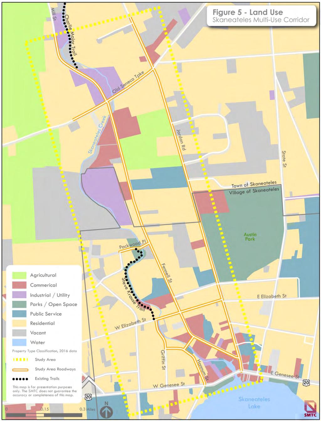
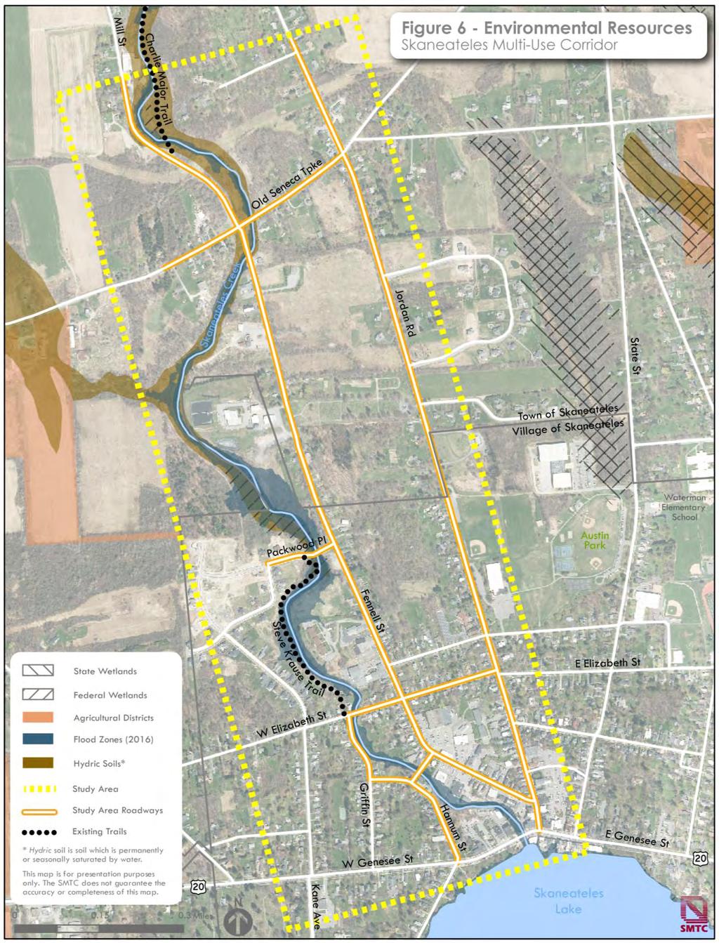
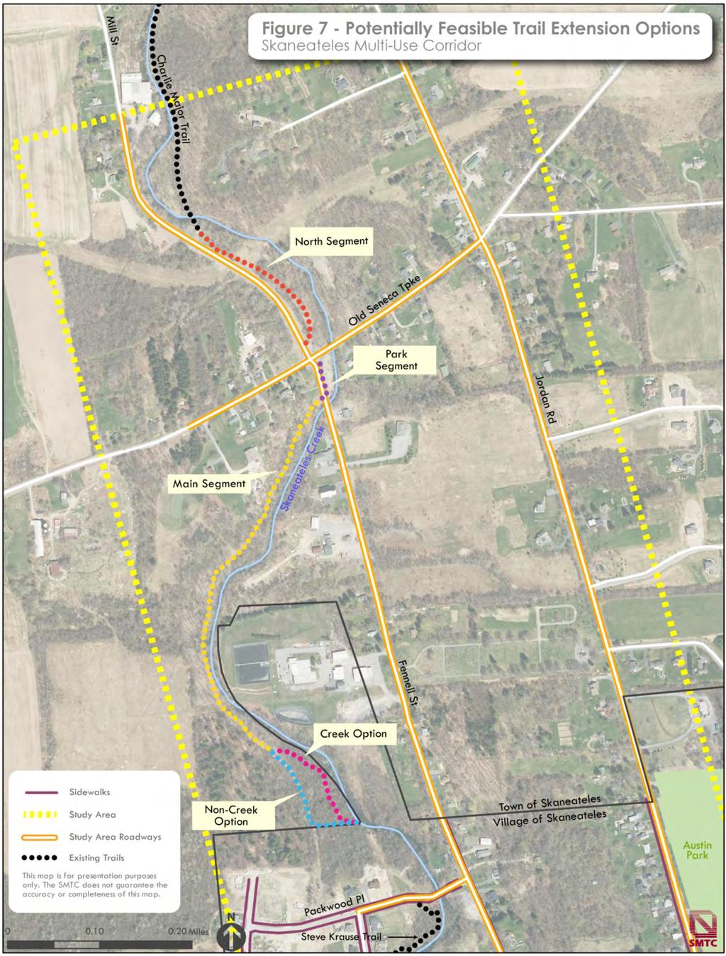
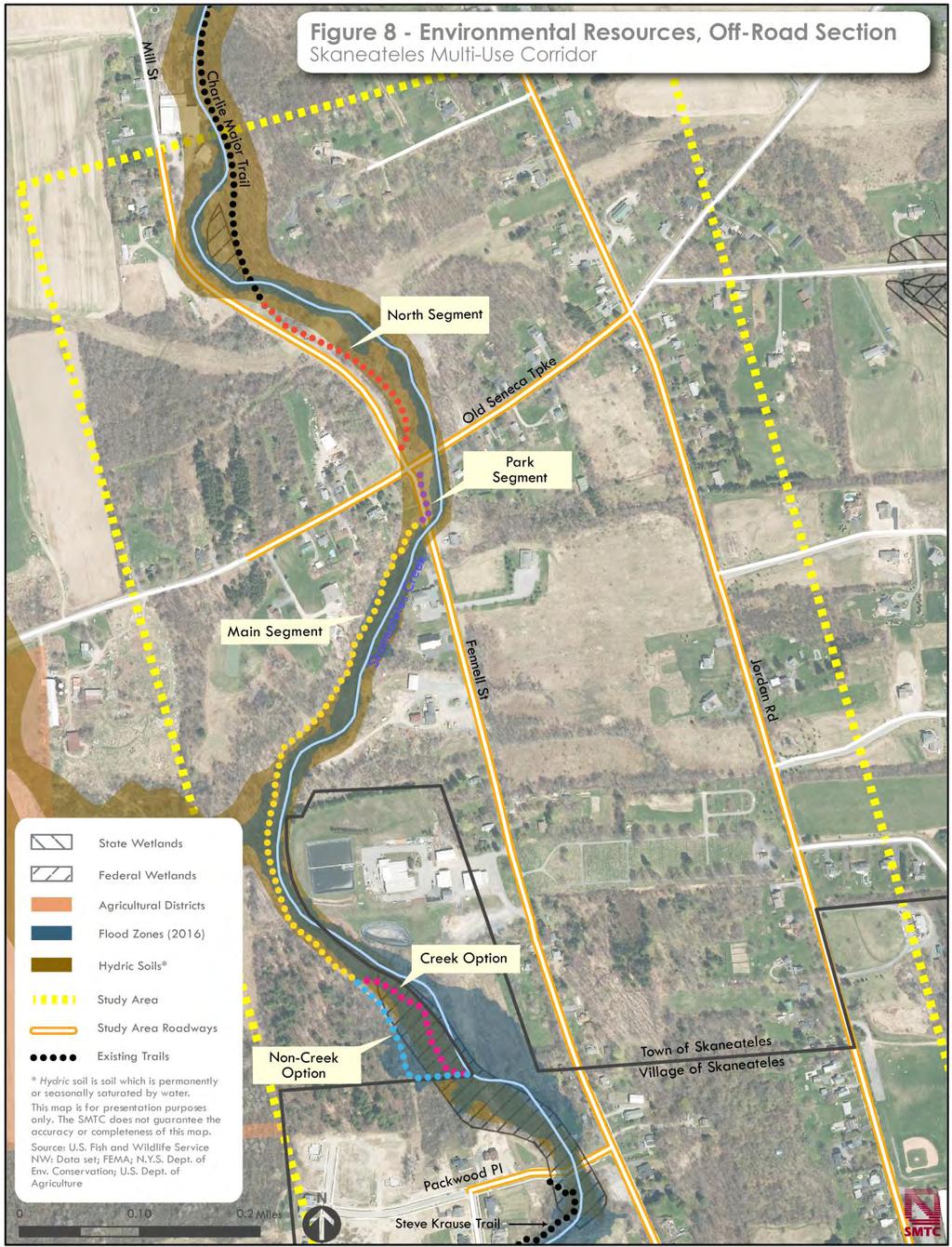
18 3.2 Study Area Land Use As shown in Figure 5, the study area within the Town of Skaneateles primarily consists of low density rural residential uses with most of the land held in private ownership. The City of Syracuse Water Department owns land in the northeast corner of the intersection of Fennell Street and Seneca Turnpike. Also at that intersection, a small park, known as Davey s Park, exists at the southeast corner. A few commercial properties exist along Fennell Street. North of the Village, land use patterns is wooded rural mixed with rural suburban. Land uses within the Village of Skaneateles include small lot village-style single-family housing. Neighborhoods include sidewalks within the study area. A wastewater treatment plant exists in the north, adjacent to the municipal boundary. Land uses change from residential to commercial south of West Elizabeth Street. 3.3 Environmental Resources Development near creeks and other waterways often involves impacts to sensitive environmental resources. Where there is a creek, there is typically a floodplain, steep slopes, wetlands, and hydric soils. (Hydric soils are sufficiently wet in the upper part to develop anaerobic conditions during the growing season.) Figure 6 shows all of the existing mapped environmental constraints. information and assumes a 20-foot wide impact area (to accommodate a 10-foot wide trail with 5-foot wide clearance areas). However, actual impact width will vary given slope conditions, but an assumption of 20-feet was used for this planning-level assessment. As shown on Figure 7, possible trail routes were divided into segments to assess impacts by location. The potential trail alignments were determined using orthoimagery, oblique aerial imagery, and Lidar data (Figure 8) for topography. The potential trail alignment appears to follow the former Skaneateles Short Line railroad bed, and the existing right-of-way for the City of Syracuse Water supply pipelines. Easements and agreements with property owners/easement holders would be necessary, and the village would need to support connecting the trail to villageowned roadways and pedestrian facilities. Site visits and environmental feature delineation were not conducted. Moreover, a preliminary database review of historic and archeological resources was not conducted as part of this assessment. These items are beyond the scope of this planning study. If a trail concept advances to a design phase, it is likely that land surveys and detailed impact assessments would be necessary to quantify impacts and determine final design parameters. The planning-level assessment was based on a desktop review of available mapped Page 13
19 Page 14
20 Page 15
21 Page 16
22 Wetlands The National Wetlands Inventory (NWI) maintained by the U.S. Fish and Wildlife Service shows two (federal) wetlands in the study area: A 0.6 acre wetland on the east side of Skaneateles Creek above the southern terminus of the Charlie Major Trail A 6.2 acre wetland located on the west side of Skaneateles Creek south of the wastewater treatment plant. While the New York State Department of Environmental Conservation s (NYSDEC) wetland mapping program does not show any state-protected wetlands in the study area, there are hydric soils along and adjacent to Skaneateles Creek, which indicates that wetlands may be present than have not been mapped to date. Potential Wetland Impacts As shown in Figure 8, the North, Town Park, and Main segments of the corridor avoid known mapped wetland areas. At the southern end of the corridor, both the Creek and Non-Creek segments appear to bisect a wetland south of the wastewater treatment plant. The Creek segment appears to impact approximately 0.3 acres of mapped wetlands, compared to approximately 0.1 acres of mapped wetlands impacted under the Non-Creek segment. As noted above, hydric soils are found throughout the length of the corridor. The total length of the corridor, using the Non-Creek segment, would impact approximately 1.5 acres of hydric soils. Using the Creek segment, total corridor impacts are anticipated to be slightly greater at approximately 1.8 acres. As a planning-level assessment, this study does not include a formalized wetland delineation. A wetland delineation, impact assessment, and applicable permits from the NYSDEC and/or the U.S. Army Corps of Engineers (ACE) may be required (and would help the licensed engineer/landscape architect determine the final trail alignment and design) if the community decides to pursue an off-road trail option. Agricultural Districts Approximately 12,100 acres in the Town of Skaneateles are classified as farmland (45 percent of the Town s land area not including Skaneateles Lake). Selected agricultural parcels in Skaneateles are part of Onondaga County Agricultural District 2, which encompasses a total of 47,230 acres in the Towns of Marcellus, Skaneateles, and Spafford. A small portion of agricultural district land is adjacent to the study area on the west side of Skaneateles Creek, north and south of Old Seneca Turnpike. None of the corridor segments appear to encroach within an agricultural district. Page 17
23 Page 18
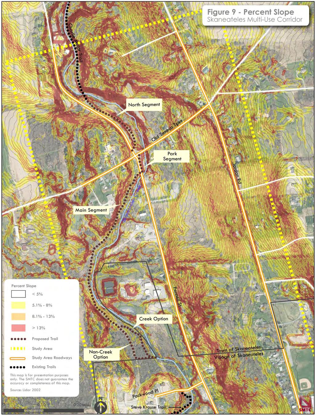
24 Flood Zones The City of Syracuse regulates water levels in Skaneateles Creek by adjusting flows at the dam near Skaneateles Lake. Skaneateles Creek is also identified in the Onondaga County Hazard Mitigation Plan as a flood problem area. The Skaneateles Creek channel and adjacent upland areas have been designated as part of a Special Flood Hazard Area (Flood Zone AE). This designation means that these areas are inundated by 1% annual chance flooding. All development within Special Flood Hazard Areas is subject to floodplain development regulations. Additionally, Federal Emergency Management Agency (FEMA) mapping shows the channel of Skaneateles Creek as a floodway in the vicinity of the wastewater treatment plant. Structures proposed to encroach on a floodway are typically studied to ensure that they do not alter the Base Flood Elevation. Floodplain Acreage The North and Town Park segments are outside of the floodplain. South of the Town Park segment, the corridor runs through the Skaneateles Creek floodplain. Total floodplain area impacted is on the order of approximately one acre, with the Creek segment adding an additional (approximate) tenth of an acre of floodplain acreage than the Non-Creek segment. Steep Slopes Topography varies considerably in the study area and was used as a major factor in identifying the potential route for an offroad trail along Skaneateles Creek. A desktop assessment using Lidar Data (2002) in GIS helped determine that a reasonable route exists along the creek and enabled an estimate of potential impacts to slope areas. As a planning-level assessment, an official site survey was not conducted, but may be required to determine design considerations (e.g., retaining walls, erosion control, etc.) if the community decided to pursue an off-road trail. Steep Slope Acreage As shown in Figure 9, the Creek and Non- Creek segments, as well as the majority of the Main Segment, would traverse relatively flat areas, with slopes under 5 percent. The Town Park Segment would run along a fairly steep grade, with nearly a quarter of its length on a grade greater than 13 percent. The North Segment would also be fairly steep, with nearly half of its length on a grade of eight percent or more. Impacts and mitigation for areas with steep slopes would need to be assessed further if consideration for an off-road trail was considered. Page 19
25 Page 20
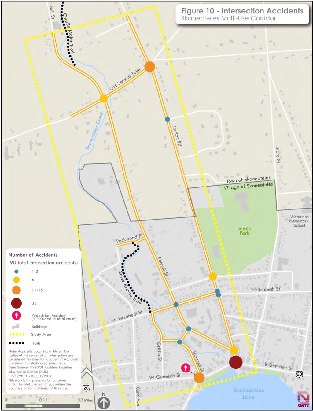
26 3.4 Accident Assessment The following accident summary is based on the New York State Department of Transportation s Accident Location Information System (ALIS) data for the most recent available five-year period, September 1, 2011 through August 31, Accidents that occurred at intersections are shown on Figure 10. Accidents that occurred along roadway segments outside of the intersection are shown on Figure 11. According to ALIS, a total of 140 accidents occurred in the study area roads during this five-year time period. The Department of Motor Vehicles (DMV) categorizes accidents into different categories; the following category of events occurred on study area roadways: Non-Reportable (61) Injury (5) Property Damage (56) Property Damage and Injury (18) Fatalities (0). All recorded events have at least one apparent contributing factor (i.e., human, vehicular, and/or environmental, etc.) recorded on the accident report. The top three contributing factors within the study area consist of: Failure to Yield Right of Way (29) Driver Inattention (27) Backing Unsafely (16). The summary analysis classified intersection accidents as having occurred within 10 meters of the center of an intersection. Although additional accidents were located near an intersection, based on data coordinates, they were indicated as non-intersection accidents if they fell outside this 10-meter range. Based on these assumptions, the ALIS dataset identified that approximately one-third of accidents occurred along a segment of roadway in between intersections, and approximately two-thirds (64 percent) of all accidents occurred at intersections. Pedestrian and Bicycle-Related Events Over the five-year period, 1 accident event involved a pedestrian; this event occurred at Hannum Street and Route 20. There were no accidents that involved a bicyclist. The number of accidents involving a bicycle or pedestrian is low (i.e., <1% of total events), but the one pedestrian accident resulted in a serious injury. Bicycle and pedestrian accidents typically result in much higher rates of injuries and fatalities than collisions that do not involve a pedestrian or bicyclist. Improving bicycle and pedestrian facilities could potentially help to reduce the number and severity of accidents for all roadway users within the study area. Page 21
27 Page 22
28 Page 23
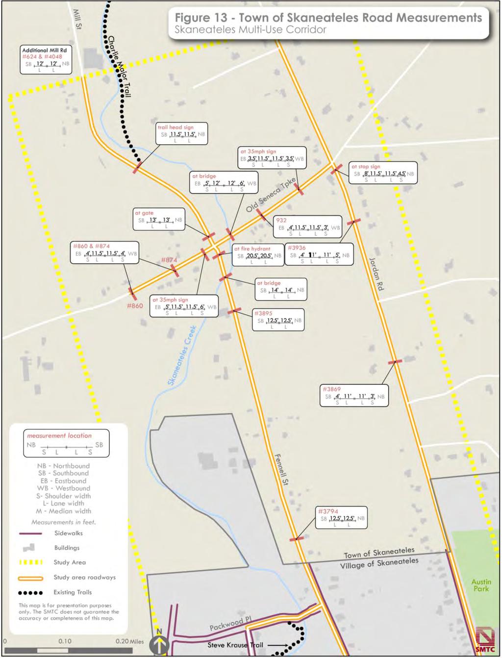
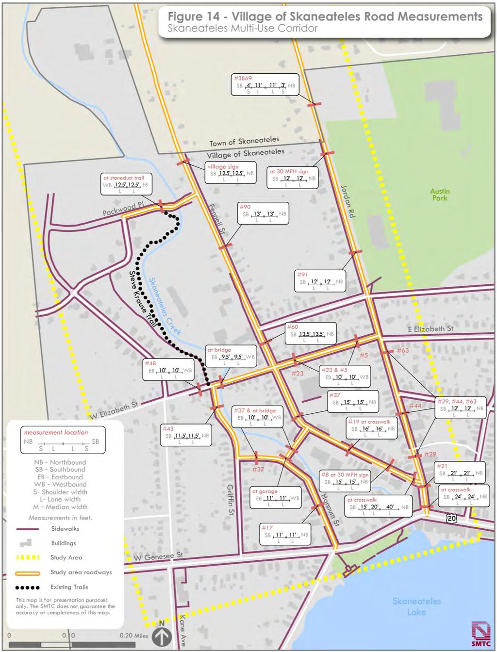
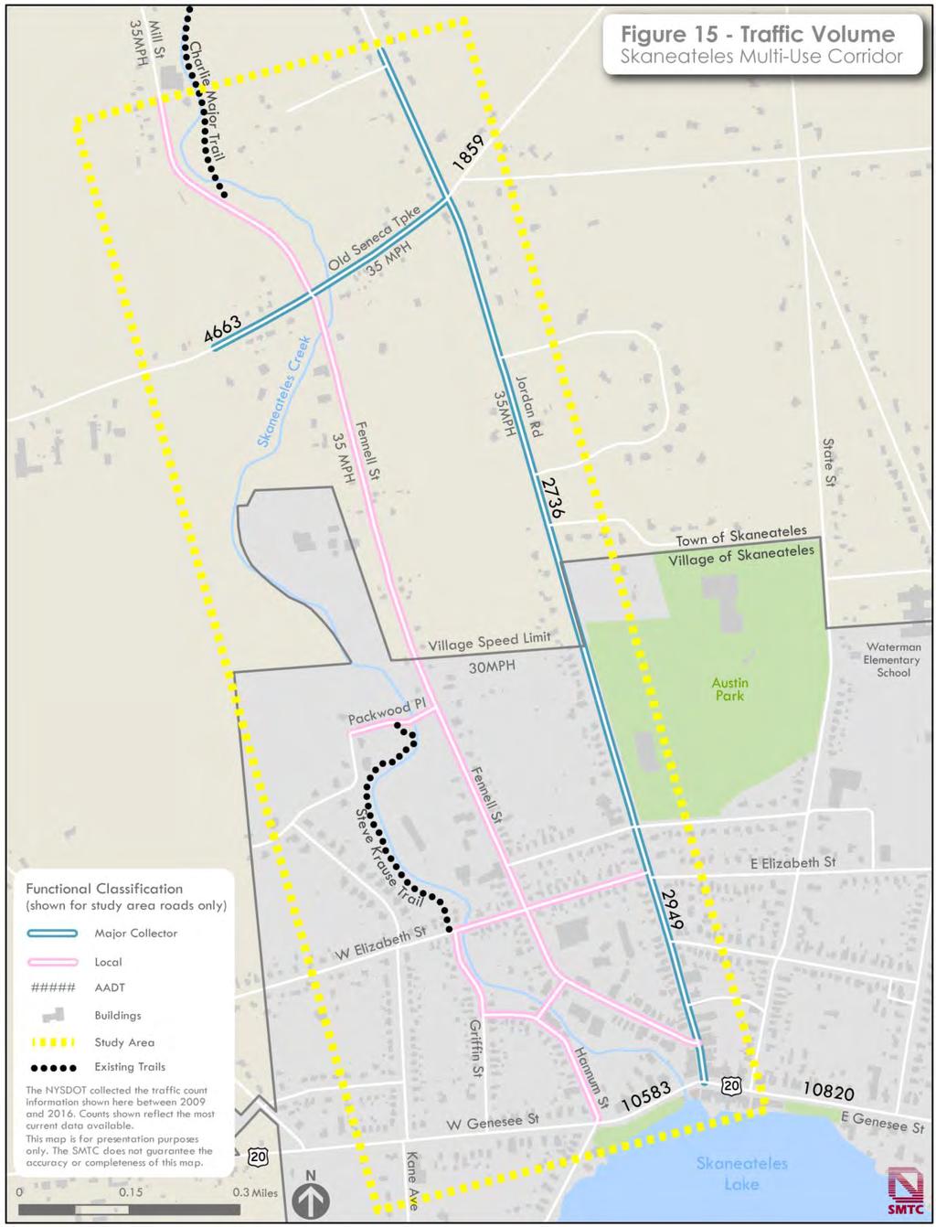
29 3.5 Physical Conditions The SMTC collected physical condition information about the study area roadways. Information included transit stops and shelter locations, typical lane and shoulder widths, roadway ownership and functional classification, location of pedestrian and bicycle facilities, and other qualitative observations. Pavement ratings and traffic volumes were also considered for federal aid eligible (FAE) roadways. Transit The Central New York Regional Transit Authority (Centro) provides bus service through the Village of Skaneateles on Route 236 and 138, which provide service between Syracuse and Auburn. These routes runs solely along State Route 20 (East and West Genesee Streets in the Village), with bus stops provided at intersections. Pavement Ratings The SMTC rates pavement quality for portions of the FAE road network in the MPA as part of its Bridge and Pavement Condition Management System annual report. The report uses a rating scale of 1 to 10 that evaluates the pavement s condition according to its level of distress. These score are: Good (7 to 8): Distress symptoms are beginning to show Excellent (9 to 10): No pavement distress. In the study area, Jordan Road and Old Seneca Turnpike were rated in the most recent inventory of roadway conditions. Old Seneca Turnpike was rated as good in the study area. Two segments of Jordan Road were also rated as good : between State Route 20 and Austin Street, and north of the Village boundary to Old Seneca Turnpike. The segment of Jordan Road south of the Village boundary to Austin Street was rated as excellent, while the segment north of Old Seneca Turnpike to Parker Lane was rated as fair. Figure 12 provides an overview of pavement ratings in the study area. Roadway Characteristics Figures 13 and 14 summarize roadway measurements in the study area, including shoulder and lane width measurements made at various points along major roads in the area. These figures also indicate where sidewalks exist within the community. Figure 15 shows the study area s roadway classification, traffic volume, and posted speed limit. A brief summary of these roadway characteristics follows. Poor (1 to 5): Pavement distress is frequent and may be severe Fair (6): Distress is clearly visible Fennell Street (Town) Fennell Street is a north-south roadway with an average annual daily traffic (AADT) Page 24
30 Page 25
31 Page 26
32 Page 27
33 Page 28
34 volume of fewer than 2,000 vehicles. Fennell Street is classified as a local road, indicating that it is not intended for long distance travel. Fennell Street s southern terminus is its intersection with Jordan Street in the Village of Skaneateles. North of the Village, Fennell Street terminates at Old Seneca Turnpike at the Fennell Street / Mill Road intersection. This road is locallyowned and maintained, meaning that the Town and Village have jurisdiction over their respective portions of the road and that it is not a FAE roadway. Fennell Street is a two-lane facility, varying in width from 30-feet in the Village s central business district, to 25-feet in the area just south of Skaneateles Creek, to 41-feet just south of Old Seneca Turnpike. Lanes are not striped on most of the roadway s length. The speed limit is 30 MPH in the Village (a limit is not posted in the Town). Granite curbs are present in the segment between the road s southern terminus and Packwood Place. Sidewalks are present on both sides of the road south of the Skaneateles Ambulance Volunteer Emergency Services building at 77 Fennell Street. Between this building and the Village s boundary, a sidewalk is provided on the east side of the road. Sidewalks are not present north of the village. Jordan Street/Jordan Road (County) Jordan Street (County Road 22 in the Village of Skaneateles and County Road 122 north of the village) is a north-south FAE roadway with an AADT of 2,600 vehicles. Jordan Street is in the village and it becomes Jordan Road is in the town. Jordan Road is county-owned (Jordan Street is villageowned) and classified as a Rural Major Collector a classification that indicates that it provides a link between local roads and larger arterial facilities. Jordan Street (Jordan Road) is a two-lane facility, varying in width from between 24- and 26-feet in the village, widening to feet south of Old Seneca Turnpike. The road has sidewalks on both sides between its southern terminus and Austin Street; north of Austin to the village line, there is a sidewalk on the west side of the street only. North of the Village, there are no sidewalks, but a four-foot shoulder is present on the west side of the road and a five-foot shoulder is present on the east side. The speed limit is 30 MPH in the village (35 MPH north of the village). Old Seneca Turnpike (County) Old Seneca Turnpike (County Road 133) is a six-mile long east-west route that runs between the Village of Marcellus (to the east) and Cayuga County (to the west). It is a FAE county-owned road, classified as a Rural Major Collector. The speed limit on Old Seneca Turnpike is 55 MPH for most of its length, but there is a 35 MPH speed zone east of Jordan Road to roughly a third of a mile west of Fennell Street. Page 29
35 East/West Genesee Street (State) East/West Genesee Street (U.S. Route 20) is a FAE east-west route that is also part of the National Highway System (NHS). Although within the study area, the work scope limits the study of Route 20 to the crosswalks across Hannum Street and across Jordan Street. Route 20 has a 30 MPH posted speed limit and an AADT of more than 10,000 vehicles. The roadway is a two-lane facility at Hannum Street and a four-lane facility at Jordan Street. Crosswalks are provided at each approach at Jordan Street and along the westbound, southbound, and northbound approaches at Hannum Street. There are no shoulders for any of the listed roadways. The posted speed limit for these roadways is 30 MPH, except for Mill Road, which is posted as 35 MPH. As indicated above, measurements for travel lanes are the only additional information available for these non-fae roadways. Local (Village and Town-owned Roadways) The remaining roadways within the study area include those owned by the village or town (owners listed in parenthesis): Jordan Street (Village) 24-to 26-feet wide Kelley Street (Village) two 10-foot travel lanes; crosses Skaneateles Creek Griffin Street (Village) two 11.5-foot travel lanes West Elizabeth Street (Village) two travel lanes that vary from 9.5-feet to 10-feet wide Packwood Place (Village) two foot travel lanes; crosses Skaneateles Creek Mill Road (Town) two travel lanes that vary from 11.5-feet to 12-feet wide. Page 30
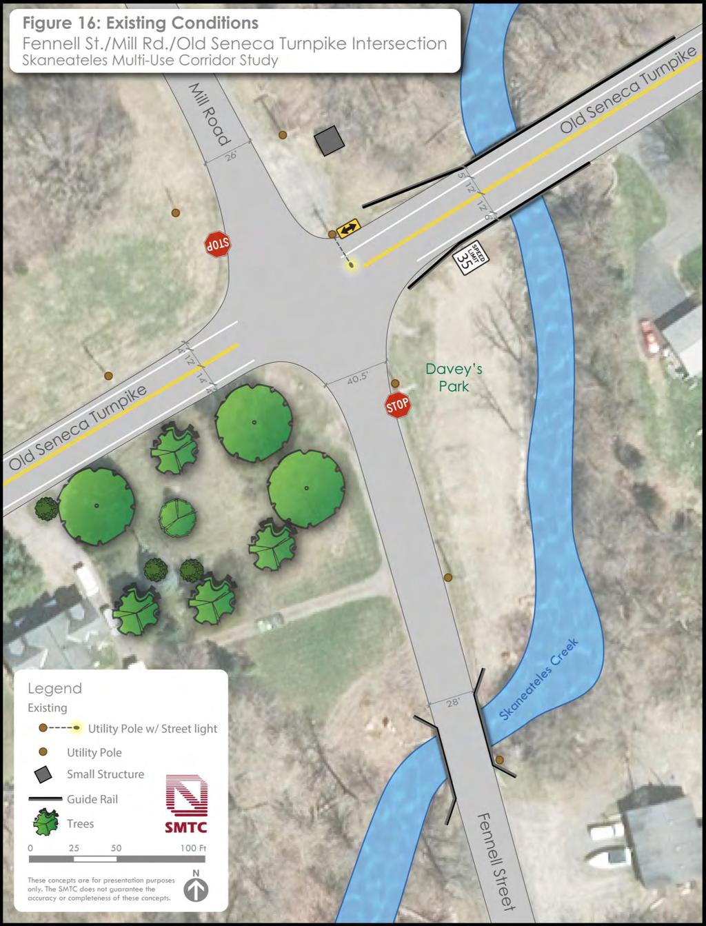
36 4 Bicycle and Pedestrian Amenity Options This chapter informs local residents, business owners, and community leaders about potentially feasible options for onroad and off-road bicycle and pedestrian amenities along Fennell Street from the Charlie Major Trail to Jordan Street. Potential improvements are based on a comprehensive planning-level assessment, which involved participation and oversight by the owners of the roadways (i.e., Onondaga County Department of Transportation, Town of Skaneateles, Village of Skaneateles, and the New York State Department of Transportation). This planning process ensured that the ideas were well-vetted with the roadway owners and that further consideration is possible if the local community expresses an interest. Some of the options are more complex than others and may need engineering, design, and environmental review if a road owner were to consider them further. For reference, Appendix B includes a sheet that outlines basic bicycle and pedestrian facilities that are mentioned in this chapter. 4.1 Focus Areas Community leaders have indicated that people do not like to walk or bike across the following two study area intersections: Old Seneca Turnpike at Fennell Street (see Figure 16 to Figure 18) Fennell Street at Jordan Street (see Figure 19 to Figure 22). The SMTC identified what options exist to add bicycle and pedestrian amenities in the focus areas. Community leaders also wondered if the Charlie Major Trail could be extended to the village. As discussed in Chapter 3, a potential alignment was assessed. Figure 23 shows the context of the two focus areas in relation to the trail and Fennell Street. A statement is not being made if a particular option should be considered, because it is up to the community to decide what is most important to them to prioritize when creating their vision for the corridor. 4.2 Intersection - Old Seneca Turnpike/Fennell Street/Mill Road Existing Conditions Figure 16 shows current conditions at the Old Seneca Turnpike/Fennell Street intersection, which includes: roadway measurements; and the location of existing signs, guide rails, and utility poles. The posted speed is 35 MPH. Mill Road does not completely align with Fennell Street and each road has a large turning radius to allow vehicles to turn at higher speeds. From a walker and bicyclist perspective, high speeds and longer distances are undesirable. Shorter crossing distances and slower speeds are preferred. Page 31
37 Page 32
38 Option 1 - Potential On-road Bicycle and Pedestrian Amenities Figure 17 identifies some options for onroad bicycle and pedestrian amenities. As shown in Figure 17, Fennell Street and Mill Road are re-aligned and the roadway width is narrowed at the intersection to reduce the turning radii and shorten crossing distance and encourage drivers to reduce speed when turning. A traffic engineer would need to determine the appropriate roadway geometry. In addition, several other potential improvements are identified, such as: Street lights on existing utility poles Advance pedestrian/bicyclist crossing warning signs on both sides of Old Seneca Turnpike Shark teeth (i.e., Advance Yield) pavement markings* and Yield Here to Pedestrian signs* (at sharks teeth) on Old Seneca Turnpike (*these are enhanced treatments that may require approval from the NYSDOT and/or the road owner) Stop line pavement marking on Fennell Street and Mill Road Double-yellow center lines on Fennell Street and Mill Road Edge striping from Old Seneca Turnpike onto Mill Road and Fennell Street (where possible, maintain a minimum of a 3-foot wide shoulder and 10-foot wide travel lanes) Sharrows i.e., shared lane markings (on Mill Road and Fennell Street). A sharrow is a stencil of bicycle with chevrons that is painted on the roadway. It indicates that bicyclists are allowed to use the travel lane with all vehicles. The chevrons indicate that bicyclists must travel the same direction as cars. Sharrows may also be applied as a pavement marking through the intersection (as illustrated on Old Seneca Turnpike in Figure 17.) Three high-visibility ladder crosswalks (across Mill Road, Fennell Street, and Old Seneca Turnpike westbound approach only) Bicyclist/Pedestrian warning signage along both sides and the entire length of Fennell Street and Mill Road Source: Sharrow Image courtesy of FHWA Small Town and Rural Multimodal Networks Share the Road signs along Jordan Street Page 33
39 Page 34
 or less Pedestrian-scale lights at the intersection to help alert motorists about the potential presence of pedestrians and")
.")
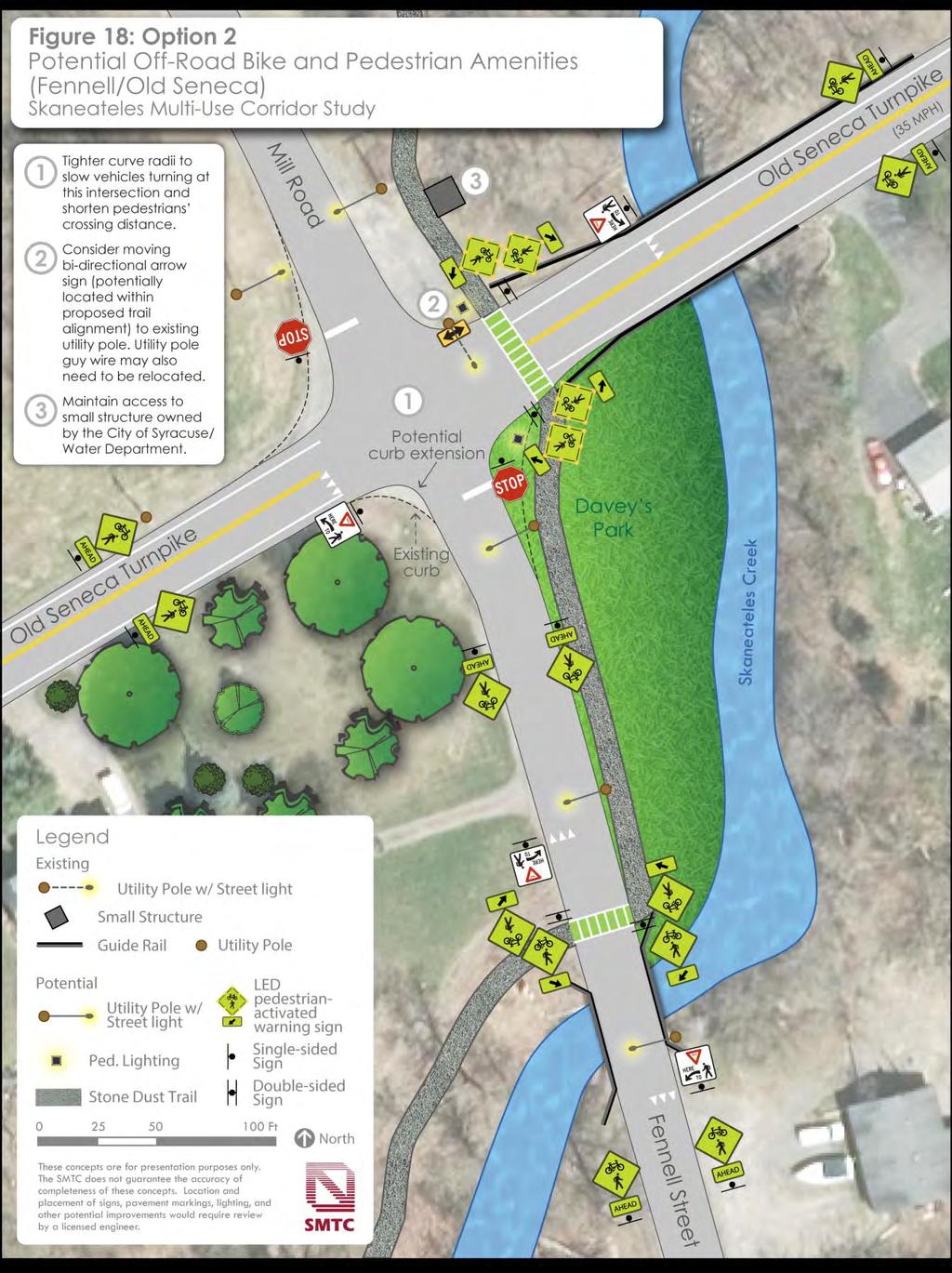
40 NYSDOT is responsible for setting the speed limits in communities with fewer than 50,000 residents. A desired speed limit for roadways with sharrows is 35 miles per hour (MPH) or less Pedestrian-scale lights at the intersection to help alert motorists about the potential presence of pedestrians and bicyclists Matching color retroreflective sign post strips to enhance sign conspicuity Double-sided warning signs on both sides of the road that either have standard flashing beacons or LEDs embedded in the sign border* (*lit warning signs are considered an enhanced treatment that may require approval from the NYSDOT and/or the road owner). The standard beacons or LEDs are activated by pushing a button on the sign post. Not illustrated on Figure 17, but a low-cost speed management technique could also involve special speed reduction pavement markings such as transverse lines inside the travel lane with decreasing spacing. These pavement markings alert drivers to slow down when approaching an intersection. Special pavement markings are considered an enhanced treatment that may require approval from the NYSDOT and/or the road owner. Source: Option 2 - Potential Off-road Bicycle and Pedestrian Amenities The previous chapter s environmental resource section determined that an alignment may be possible that could allow the Charlie Major Trail to be extended south to the village (based on a planninglevel review of mapped environmental constraints only). At a minimum, the design of any future trail would likely require the installation of culverts to cross drainage areas, elevated boardwalks in wetland areas, regrading, stone dust application, and signage. The Page 35
41 City of Syracuse regulates water levels in Skaneateles Creek by adjusting flows at the dam near Skaneateles Lake. Further investigation by licensed engineers, biologists, environmental specialists, archeologists, etc., in consultation with the City of Syracuse Water Department and other regulatory agencies is necessary to determine final design and environmental protection and mitigation measures. Off-road trails present a different pattern of pedestrian and bicycle movements when they integrate with roadways. Therefore, special consideration is necessary. For the purposes of this assessment, a stone-dust (ADA compliant) 10-foot wide shared use path is considered to complement the design and use of the existing Charlie Major Trail. A seasonal trail (i.e., not maintained during the winter) limited to walking and bicycling only is assumed. The trail alignment appears to follow the former Skaneateles Short Line railroad bed, and the existing right-of-way for the City of Syracuse Water supply pipelines. Easements and agreements with property owners/easement holders would be necessary, and the village would need to support connecting the trail to villageowned roadways and pedestrian facilities. Since extending the trail south appears to be potentially feasible, a planning-level assessment of how it could incorporate into the roadway network was considered. Figure 18 identifies what options exist to add trail amenities. Similar to Option 1, aligning Mill Road and Fennell Street and narrowing the width these roadways is identified. There are many similar design features to Option 1. Noteworthy differences include: The number of crosswalks are reduced to two to minimize vehicle conflict points. Trail/pathway crosswalks are typically wider than traditional crosswalks and accommodate walkers and bicycle riders. Two high-visibility ladder crosswalks with green paint* (across Old Seneca Turnpike westbound approach only; and across Fennell Street north of Skaneateles Creek) (*green paint incorporated into a high-visibility ladder crosswalk is an enhanced treatment that may require approval from the NYSDOT and/or the road owner) Existing utility pole guy wires may need to be relocated to accommodate an offroad trail. Similar to Option 1, special speed reduction pavement markings such as transverse lines inside the travel lane with decreasing spacing could also be considered along Old Seneca Turnpike. Speed reduction markings are considered an enhanced treatment that may require approval from the NYSDOT and/or the road owner. Page 36
42 Page 37

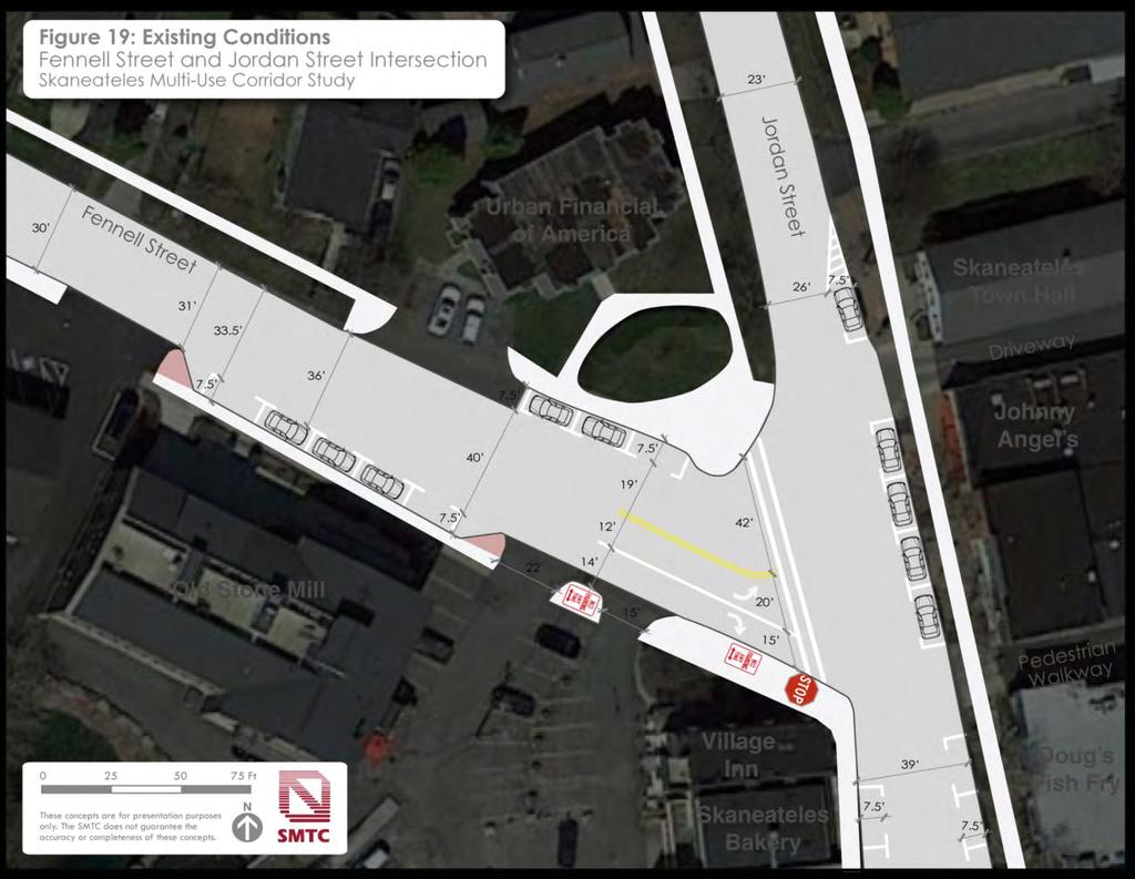
43 4.3 Intersection Fennell Street/Jordan Street Existing Conditions Figure 19 shows current conditions at the Fennell Street/Jordan Street intersection. Features highlighted within Figure 19 include measurements for the roadways, and striped travel lanes and on-street parking spaces. The location of existing signs, sidewalks, and driveway entrances are also indicated. The posted speed limit is 30 miles per hour. Fennell Street intersects Jordan Street at an acute angle. Due to this angle, the crossing distance on Fennell Street at Jordan Street is 77-feet. A 77-foot wide crossing takes an average person about 20 seconds to walk across. As mentioned, shorter crossing distances are preferred. As shown in Figure 20, Fennell Street is narrowed at the intersection to shorten the crossing distance. Driveway access to buildings and parking lots are maintained, and several other improvements, such as: Concrete sidewalks across all driveways Detectable warnings (e.g., truncated domes) at all sidewalk ramps High-visibility ladder crosswalks Shark teeth (i.e., advance yield) pavement markings* and Yield Here to Pedestrian signs* (at sharks teeth) on Jordan Street (*these are enhanced treatments that may require approval from NYSDOT and/or the road owner) Advance pedestrian/bicyclist crossing warning signs on Jordan Street Option 1 Bike Lane Concept Maintain On-Street Parking Figure 20 identifies 5-foot wide green bicycle lanes and new crosswalk pedestrian amenities, while maintaining existing on and off-road parking spaces. Source: Example of a green bike lane - image courtesy urbanmilwaukee.com 5-foot wide green bike lanes (and Bike Lane signs) on Fennell Street from Jordan Street to Kelley Street; Sharrows i.e., shared lane markings on Jordan Street, and on Fennell Street (from Kelley Street to Old Seneca Turnpike not shown on Figure 20) Stop line on Fennell Street Double-yellow center line with striped turn lanes on Fennell Street Matching retroreflective sign post strips on bicycle and pedestrian signs Page 38
44 Page 39
45 Page 40
46 Option 2 Bike Lane Concept with additional On-Street Parking As shown in Figure 21, Option 2 is the same as Option 1, but it increases the number of on-street parking spaces through access management strategies. A planning-level assessment was conducted to determine what trade-offs may be required to increase on-street parking along Fennell Street. On-street parking is a valuable asset within a business corridor: it adds parking spaces for shoppers; it encourages motorists to drive slower; and it serves as a buffer between the sidewalk and vehicles driving on the road, which increases a pedestrian s sense of safety. those trade-offs would likely occur. A roadway survey would be required to determine the official right-of-way and adjacent property boundaries. Option 2 identifies three driveway closures and the loss of approximately ten off-street parking spaces (four off-street spaces could be lost at Urban Financial of America and six spaces could be lost in front of Salt Fitness, which is outside of the area shown in Figure 21). However, the ten lost spaces could potentially be offset by ten new on-street parking spaces; two in front of Urban Financial of America, and eight between the Old Stone Mill and Salt Fitness. Regarding bicyclists, cyclists must ride far enough away from cars parked along the street to avoid dooring (i.e., when someone accidently opens a car door in the path of a bicyclist). When space permits, a buffer should be incorporated between the parked cars and the bicycle lane. Prioritizing on-street parking usually requires driveway closures. On the plus side, closing driveways reduces conflict points (i.e., areas where accidents can occur) such as along a sidewalk. This greatly improves safety and is supported in other community plans (see Chapter 2). However, closing driveways affects parking lots sometimes for better (e.g., adds additional space to park cars), sometimes for worse (e.g., reduces ease of access, etc.). This assessment identifies where Page 41
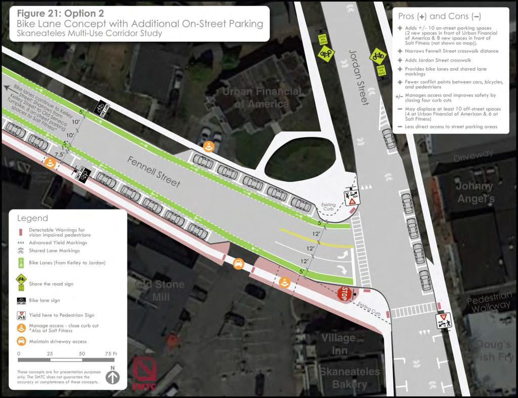
47 Page 42
48 Option 3 Roundabout Concept Roundabouts offer a unique opportunity to improve safety and aesthetics. They also promote continual traffic flow, although there are instances when drivers must yield. Some roundabouts include a central feature such as a fountain or a monument. Some roundabout designs, however, can adversely impact pedestrian mobility. An assessment of the existing intersection geometry was made to consider if a roundabout could potentially fit. Pros and cons were also identified using a generic roundabout design that reflects a typical diameter. Official road right-of-way (ROW) boundaries are not known; however, a review of (nonofficial) parcel maps suggest that - although close - a generic roundabout design does not appear to fit. A customized design and a site survey was beyond the scope of this assessment. An official site survey and preliminary design by qualified engineers would be required to make an official determination. Survey and design are beyond the scope of this general planning-level assessment. As shown in Figure 22, a generic single-lane roundabout was superimposed to help illustrate pros and cons. Existing curb lines (not road ROW boundaries, and not parcel lines) are shown to give a sense of the scale. Since driveways are not allowed to open into the roundabout, a few driveways would need to close. On-street parking is also prohibited within a roundabout, which would affect approximately five spaces along Jordan Street, and up to four offstreet parking spaces may be affected along Fennell Street. However, as shown on Figure 22, the option to provide additional on-street parking along the south side of Fennell Street (to help off-set some of the lost spaces) still exists. Three high-visibility ladder crosswalks and two pedestrian refuge islands are shown to help maintain pedestrian mobility. It may also be necessary to restrict driveways near the roundabout as right-in, right-out only. Sharrows would be necessary along Jordan Road and Fennell Street to accommodate bicyclists. 4.4 Remainder of Study Area Figure 23 shows the location of the two focus areas within the greater context of the study area. The Village of Skaneateles has a well-established sidewalk network that services a large section of the study area. However, opportunities exist to systemically enhance the network through the application of the following principles during future maintenance and reconstruction activities: Sidewalk and Crosswalk Considerations Concrete sidewalks should be at least 5- feet wide (potentially wider in business areas) Page 43
49 Page 44
50 Page 45
 Example: A concrete sidewalk extending across a driveway.")

51 Ensure concrete sidewalks are continuous through all driveways Provide high-visibility ladder crosswalks to connect sidewalks at intersections and at mid-block crossings (see New York State Pedestrian Safety Action Plan for additional safety-related treatments including signage, advanced yield markings sharks teeth, etc.) Example: A concrete sidewalk extending across a driveway. When cross-slopes change rapidly over a short distance, wheelchair use is unstable, therefore, maintain a level sidewalk whenever practicable. Provide curb-cuts and detectable warnings at all intersections with sidewalks Sidewalks and associated facilities should comply with the Americans with Disabilities Act and the 2011 guidelines as set forth in the Public Rights of Way Accessibility Guidelines (PROWAG) The New York State Pedestrian Safety Action Plan (PSAP) provides guidelines for systemic safety improvements Source: Designing Sidewalks and Trails for Access, July 1999 (Figure 4-6) An example of a preferred design in shown below and should be considered when practicable. Matching color retroreflective sign post strips to enhance warning sign conspicuity. Historically, a sidewalk was never extended north of the village along Fennell Street given the rural nature and lack of residential properties. However, should the Town ever consider extending a sidewalk from the village, placing one on the east side of the road would service the greatest number of residential properties and keep pedestrians on the same side of the road as the Charlie Major Trail. Source: Designing Sidewalks and Trails for Access, July 1999 (Figure 4-20) Page 46
52 Accommodate Bicyclists The roadways within the study area, including most of Fennell Street, are not wide enough to accommodate bicycle lanes. Bike lanes are identified as potentially feasible on Fennell Street from Kelley Street to Jordan Street - as shown in Figure 20 and Figure 21. Granite curbs also exist along many roadways within the village. Therefore, where bike lanes are not identified, sharrows (i.e., shared lane pavement markings) and Share the Road signs may be considered as a potential treatment options to accommodate bicyclists. 4.5 Public Feedback As a planning-level assessment only, the SMTC made the document available online for a two-week period to allow for public comment. On [DATE TO BE INCLUDED], the SMTC posted a draft of the report to its website ( The comment period provided local residents, business owners, and community leaders the opportunity to provide feedback on the assessment and the options identified. amenities were potentially feasible along Fennell Street between the Charlie Major Trail and Jordan Street in the village. This assessment was conducted at no cost to the local community and the community was afforded the opportunity to review and comment on the potentially feasible planning-level options that exist. As mentioned, the identified options are intended to inform local residents, business owners, and local leaders about what opportunities may exist. The town, the village, and agency road owners are under no obligation to implement any of the ideas or options identified in this report. The community is welcome to use this report to generate discussion, determine their level of interest, and coordinate with road owners if necessary. The SMTC is available as a resource to answer any questions about the planning process and provide planning assistance with member agency road owners if necessary. The final report may be found on the SMTC website: ( To be included following completion of public comment period. A copy of received public comments is provided in Appendix C. 4.6 Conclusion The Town of Skaneateles requested that the SMTC conduct an objective study to determine what pedestrian and bicycle Page 47
53 Skaneateles Multi-Use Corridor Study Appendix A Public Involvement Plan (PIP)
54 S K A N E A T E L E S M U L T I - U S E C O R R I D O R S T U D Y Public Involvement Plan October 2016 (Updated February 2018) Financial assistance for the preparation of this document was provided, in part, by the U.S. Department of Transportation s Federal Highway and Federal Transit Administrations and the New York State Department of Transportation. The Syracuse Metropolitan Transportation Council (SMTC) is solely responsible for its content. For further information, contact: Michael D. Alexander, AICP, Project Manager Syracuse Metropolitan Transportation Council 126 N. Salina Street, 100 Clinton Square, Suite 100 Syracuse, New York Phone: (315) ; Fax: (315) ; malexander@smtcmpo.org
55 Skaneateles Multi-Use Corridor Study Public Involvement Plan I. Introduction Engaging the public early and often in the planning process is critical to the success of any transportation plan or program. When people are involved in a decision-making process and can see how their input has influenced that process, they are more likely to adopt its outcomes. As the Federal Highway Administration/Federal Transit Administration guidebook Public Involvement Techniques for Transportation Decision- Making states: Through continued interaction with the entire community, agencies build community support and, more importantly, assure that the public has the opportunity to help shape the substance of plans and projects. The importance of public involvement is underscored by the fact that it is required by numerous state and federal laws. Metropolitan Planning Organizations (MPO) such as the Syracuse Metropolitan Transportation Council (SMTC) must provide citizens, affected public agencies, businesses, local government, and other interested parties with a reasonable opportunity to comment on transportation plans and programs. This Public Involvement Plan (PIP) is intended to supplement the Scope of Work approved in August II. Background In 2014, the Town formed an ad hoc citizen-led multi-use trail committee (MUTC) to envision transforming the former Skaneateles Short Line Railroad corridor into a railsto-trail project. The envisioned trail would connect the Village of Skaneateles with the hamlets of Mottville and Skaneateles Falls along the abandoned rail corridor. However, some community members favor the envisioned concept and others strongly oppose it. In November 2015, the Town of Skaneateles approached the SMTC seeking professional planning assistance. The SMTC selected the Study for the program year. Two significant changes occurred prior to kicking off the Study: approximately 50 residents filed a formal petition opposing the Study, and a new Town supervisor was elected. During the scoping process, which began in April 2016 and concluded in August 2016, staff from the SMTC met with representatives from the town and village to ensure that support remained for conducting this assessment. The Town Supervisor and the Village Mayor limited the Study s scope to only consider on-road bicycle and pedestrian facilities within the village, and on-road and off-road pathway facilities in the town (from the village s northern boundary to the southern end of the Charlie Major Trail.) As a result, some meetings identified in the scope were no longer necessary. 1
56 Skaneateles Multi-Use Corridor Study Public Involvement Plan III. Purpose The purpose of the Skaneateles Multi-Use Corridor Study (Study) is to assess the feasibility of improving on-road bicycle and pedestrian facilities within the village and town study area, and off-road pathway facilities within the town. IV. Goals The intent of the Public Involvement Plan (PIP) for the Study is to engage the public by: (1) Creating public awareness of the Study s goals, objectives, and process, as well as to document public comment on draft recommendations, and (2) Solicit public input into the decision making process. V. Study Advisory Committee A Study Advisory Committee (SAC) will be established to provide technical and procedural guidance throughout the Study. At a minimum, a representative from the following agencies will serve on the SAC: The Village of Skaneateles The Town of Skaneateles New York State Department of Transportation (NYSDOT) Onondaga County Department of Transportation (OCDOT) Syracuse-Onondaga County Planning Agency (SOCPA) Central New York Regional Planning and Development Board (CNYRPDB). The SAC will meet as needed with the SMTC to assist in the Study. The SAC s role will be to advise the SMTC on the technical content of deliverables and to provide needed input and guidance. The SAC will not vote on approval or disapproval of Study-related documents. The SMTC anticipates holding up to three SAC meetings (as needed) over the course of this Study, as shown below. SAC meeting no. Anticipated purpose 1 Kickoff: confirm Study purpose, goals, objectives, schedule, and PIP. 2 Review and confirm existing conditions findings, facility opportunities, and issues. Brainstorm recommendations and public engagement needs. 3 Review public feedback and draft report. Securing a SAC meeting location, announcing SAC meetings through mail/ , conducting SAC meetings (including preparation of agenda, materials, presentations, 2
57 Skaneateles Multi-Use Corridor Study Public Involvement Plan etc.), and preparing the minutes from each meeting will be the responsibility of the SMTC. VI. Public Outreach Initially, the SMTC anticipated a possible need to conduct an informal focus group meeting and a public meeting. However, as the Study evolved into a planning-level assessment only, it was determined - in consultation with the Study s sponsor - that a two-week comment period would provide a better opportunity to obtain public comment from a broader audience over a longer time period than a one-time public meeting. A planning-level assessment identifies several options for consideration, but does not make recommendations nor proposes a course of action. The Study s sponsor has indicated that a two-week public comment period would help gauge the level of public interest. The SMTC will summarize all comments in the report and will provide a general assessment of the level of public interest. The sponsor indicated that it may consider hosting its own public meeting (following the completion of the final report) should the public express interest in any ideas identified in the Study. The SMTC would be available as a resource should the community conduct a future public meeting. The SMTC will post the draft report online and notify the public through a press release that it is available for public review and comment. The SMTC will send a copy of the press release to the SAC and to stakeholders for further dissemination throughout the community. The SMTC will include the press release on the homepage of its website ( and will share the press release through its social media (i.e., Facebook) page. The SMTC reserves the right to postpone the Assessment and conclude the Study if the community does not support this Study process. VII. Additional public outreach Stakeholders list Stakeholders are those individuals that have a significant personal or professional interest in the Study. In consultation with the SAC, the SMTC will work compile an initial list of stakeholders based on staff and SAC members existing knowledge of the community. Additional stakeholders will be added continuously at the request of the SAC or any community member. The stakeholders will be sent pertinent Study information, kept apprised of significant Study developments, notified of all public outreach opportunities, and encouraged to provide feedback and comment regarding the assessment. 3
58 Skaneateles Multi-Use Corridor Study Public Involvement Plan Coordination with community groups If necessary, staff from the SMTC will reach out to existing community groups in the Study area and seek their assistance in notifying their members about the Study in general and specifically about the public meetings. If requested, SMTC staff will attend existing community meetings to provide a brief overview of the Study. A relevant community group for this Study may include: the local chamber of commerce. The SMTC will work with the SAC to refine or update this list as necessary throughout the Study. Village/Town-Sponsored Meetings The SMTC may attend up to two town/village-sponsored meetings at which this assessment in question is being discussed as an agenda item, if requested by the municipality. Distribution of Study materials If deemed necessary (at the discretion of the SAC and/or other appropriate SMTC committees), the SMTC may distribute Study-specific information at sites throughout the Study area (e.g. schools, community centers, libraries, etc.). This information may include one or more of the following: introductory flier, meeting notice, comment card, and a pre-addressed survey on a particular Study issue. It is also the SMTC s intent to work with and encourage other agencies to include this information in their publications or to assist in material distribution. Approved documents, such as the Study s Final Report, may be made available at libraries in the vicinity of the Study area. News releases will be produced to announce the availability of such items, as well as invite written comments to be submitted to the SMTC. Public comment All interested individuals are encouraged to submit comments to the SMTC. This message will be publicized and made clear verbally and on Study material and publications. The public is also welcome to attend any of the publicized SMTC Executive, Planning and Policy Committee meetings, at which the Study may be on the agenda as a discussion item. VIII. Press releases and media coverage The SMTC will issue press releases announcing the details of the public comment period to all major and minor newspapers in advance. If necessary, the SMTC will also send additional news releases, or take the initiative to promote media coverage on pertinent developments pertaining to the Study. 4
59 Skaneateles Multi-Use Corridor Study Public Involvement Plan All media inquiries should be directed to the SMTC director or project manager. However, this is not always possible. If you (e.g. SMTC committee members, SAC members, and/or interested stakeholders associated with the Study) are interviewed by the media, please limit your comments to your respective agency s opinion or involvement in the Study. Speaking to the media on specific issues and questions regarding the Study, including its progress and development, is the exclusive responsibility of the SMTC. IX. SMTC publications The SMTC publishes a newsletter, DIRECTIONS, that offers news about its activities and particular studies. This newsletter is distributed to over 5,000 individuals, some of whom include the media; local, state, and federal agencies associated with the SMTC; municipal and elected officials; community agencies and representatives; and a large number of interested citizens. It is anticipated that articles on the Study (e.g. Study development issues or the announcement of a public comment period) will be published in future issues of DIRECTIONS. Should the need arise for the production of a separate newsletter/flier/report to convey a timely Study development, the SMTC staff is prepared to perform this additional task. It is also important to note that the mailing list of the SMTC newsletter, DIRECTIONS, will be updated to include all members of the SAC, stakeholders, and others interested or involved in the Assessment. The SMTC web site ( will also serve as a resource for general information about the SMTC, the Assessment, and any final reports. X. Conclusion It is important for the SMTC to understand public attitudes and values throughout the Study. Through the activities described in this public involvement plan, the SMTC will solicit public input and provide opportunities for the public to develop greater awareness of, and active involvement, in the Study. 5
60 Skaneateles Multi-Use Corridor Study Appendix B BICYCLE AND PEDESTRIAN FACILITY REFERENCE SHEET
 On-Road Bike Lane Sharrows (Shared Use Lane Markings) Users: Surface: Soil Stone Dust Asphalt or")
: <35 MPH Speed Limit (Trail): NPS emphasizes slow pace 20 MPH (30 MPH")


61 General Design Guidelines By Facility Type Class 4 Nature Trail (NPS) Shared Use Path (Unpaved) Shared Use Path (Paved) On-Road Bike Lane Sharrows (Shared Use Lane Markings) Users: Surface: Soil Stone Dust Asphalt or Concrete Asphalt or Concrete Asphalt or Concrete Tread Width: (AASHTO) 12 Minimum (NYSDOT) 5-8 <14 Speed Limit (Roadway): <35 MPH Speed Limit (Trail): NPS emphasizes slow pace 20 MPH (30 MPH downgrade) 20 MPH (30 MPH downgrade) Clearing: Height Width Grade: %-5% shoulder/seperation from bodies of water or steep slopes 0.5%-3% shoulder/seperation from bodies of water or steep slopes <5% 8-10 <5% (from curb with on-street parking <5% Max Grade: 10% 8%-13% 5%-12% 5% undesirable Traffic Volume Limits (Roadways): >3,000 AADT Low Volume (Recommended) Sources All costs were sourced from: Costs for Pedestrian and Bicyclists Infrastructure Improvements Prepared by the UNC Highway Safety Research Center for FHWA 50 National Park Service Trail Fundamentals Design Parameters AASHTO Gruide for the Development of Bicycle Facilities FHWA Designing Sidewalks and Trails for Access AASHTO Gruide for the Development of Bicycle Facilities FHWA Designing Sidewalks and Trails for Access AASHTO Guide for the Development of Bicycle Facilities NACTO Urban Bikeway Guide FHWA Designing Sidewalks and Trails for Access Image courtesy of urbanmilwaukee.com NACTO Urban Bikeway Guide MUTCD, 2009 Edition Image courtesy of FHWA Small Town and Rural Multimodal Networks
 Users: Surface: Asphalt or Concrete Wood Concrete, Wood, Metal Asphalt or Concrete General")
 >6 Speed Limit (Roadway): 40-55 MPH (Generally) >40 MPH Speed Limit (Trail): NPS")


62 General Design Guidelines By Facility Type Paved Shoulder Boardwalk Trail Bridge Trail Crossings (Roads) Users: Surface: Asphalt or Concrete Wood Concrete, Wood, Metal Asphalt or Concrete General example of a pedestrian-activated warning sign with LEDs that flash in the border Tread Width: (AASHTO) >6 Speed Limit (Roadway): MPH (Generally) >40 MPH Speed Limit (Trail): NPS emphasizes slow pace NPS emphasizes slow pace Clearing: Height Width Grade: Determined by Roadway <5% <5% <5% Max Grade: Determined by Roadway 5%-10% 5%-10% 5% Traffic Volume Limits (Roadways): Sources All costs were sourced from: Costs for Pedestrian and Bicyclists Infrastructure Improvements Prepared by the UNC Highway Safety Research Center for FHWA FHWA Designing Sidewalks and Trails for Access Architectural Barriers Act Accessibility Standards Architectural Barriers Act Accessibility Standards AASHTO Gruide for the Development of Bicycle Facilities FHWA Designing Sidewalks and Trails for Access AASHTO Guide for Planning, Design, and Operation of Pedestrian Facilities NYSDOT Highway Design Manual FHWA Informational Report on Lighting Design for Midblock Crosswalks
Connecting cyclists to work. Syracuse Metropolitan Transportation Council
 Connecting cyclists to work Syracuse Metropolitan Transportation Council Overview Prepared at request: NYS Department of Transportation (NYSDOT) Project Achievements Target group Purpose Process Recommendations
Vision: Traditional hamlet with an attractive business/pedestrian friendly main street connected to adjacent walkable neighborhoods
 N D. Focus Area II Vision: Traditional hamlet with an attractive business/pedestrian friendly main street connected to adjacent walkable neighborhoods Transit Road Focus Area II is located in the Hamlet
Agenda. Overview PRINCE GEORGE S PLAZA METRO AREA PEDESTRIAN PLAN
 PRINCE GEORGE S PLAZA METRO AREA PEDESTRIAN PLAN May 28, 2008 Agenda Welcome and introductions Project overview and issue identification Planning context and strengths Design challenges and initial recommendations
MAG Town of Cave Creek Bike Study Task 6 Executive Summary and Regional Significance Report
 Page 1 MAG Town of Cave Creek Bike Study Task 6 Executive Summary and Regional Significance Report August 1, 2012 MAG Project #481 Page 2 Task 6 Executive Summary and Regional Significance Report Introduction
Chapter 5 Future Transportation
 Chapter 5 Future Transportation The Future Land Use Plan identifies the desired land use designations. The land uses desired for Crozet depend, in large part, on the success of the transportation system,
APPENDIX A: Complete Streets Checklist DRAFT NOVEMBER 2016
 APPENDIX A: Complete Streets Checklist DRAFT NOVEMBER 2016 Complete Streets Checklist MetroPlan Orlando s Complete Streets Checklist is an internal planning tool for staff to further implementation of
PRINCE GEORGE S PLAZA METRO AREA PEDESTRIAN PLAN
 PRINCE GEORGE S PLAZA METRO AREA PEDESTRIAN PLAN May 28, 2008 Agenda Welcome and introductions Project overview and issue identification Planning context and strengths Design challenges and initial recommendations
2016 Church Street Access Study. 100 Clinton Square 126 North Salina Street, Suite 100 Syracuse, NY
 2016 Church Street Access Study 100 Clinton Square 126 North Salina Street, Suite 100 Syracuse, NY 13202 www.smtcmpo.org Syracuse Metropolitan Transportation Council Final Report February 23, 2016 This
REGIONAL BICYCLE AND PEDESTRIAN DESIGN GUIDELINES
 REGIONAL BICYCLE AND PEDESTRIAN DESIGN GUIDELINES November 16, 2011 Deb Humphreys North Central Texas Council of Governments Bicycle and Pedestrian Advisory Committee Snapshot of the Guide 1. Introduction
PEDESTRIAN ACTION PLAN
 ATTACHMENT 2 CITY OF SANTA MONICA PEDESTRIAN ACTION PLAN CITY OF SANTA MONICA PEDESTRIAN ACTION PLAN This page intentionally left blank EXECUTIVE SUMMARY CHAPTER 1 EXECUTIVE SUMMARY Setting the Stage
Solana Beach Comprehensive Active Transportation Strategy (CATS)
") Solana Beach Comprehensive Active Transportation Strategy (CATS) 3.0 Goals & Policies The Solana Beach CATS goals and objectives outlined below were largely drawn from the Solana Beach Circulation Element
Solana Beach Comprehensive Active Transportation Strategy (CATS) 3.0 Goals & Policies The Solana Beach CATS goals and objectives outlined below were largely drawn from the Solana Beach Circulation Element
Omaha s Complete Streets Policy
 Omaha s Complete Streets Policy (Adopted August 2015) VISION To create great places and enhance our quality of life, the City of Omaha will provide safe, accessible streets for all users. Complete Streets
RE: Village of Skaneateles new sidewalk prioritization assessment document
 Memorandum TO: Mary Sennett, Trustee Martin Hubbard, Mayor FROM: Kevan Busa, SMTC Transportation Planner DATE: August 9 th, 2018 RE: new sidewalk prioritization assessment document Introduction In response
5 CIRCULATION AND STREET DESIGN
 5 CIRCULATION AND STREET DESIGN This chapter describes circulation and streetscape improvements proposed for the Northwest Chico Specific Plan Area. It includes detailed design specifications for existing
Proposed. City of Grand Junction Complete Streets Policy. Exhibit 10
 Proposed City of Grand Junction Complete Streets Policy Exhibit 10 1 City of Grand Junction Complete Streets Policy Vision: The Complete Streets Vision is to develop a safe, efficient, and reliable travel
Corpus Christi Metropolitan Transportation Plan Fiscal Year Introduction:
 Introduction: The Safe, Accountable, Flexible, Efficient Transportation Equity Act: A Legacy for Users (SAFETEA-LU) has continued the efforts started through the Intermodal Surface Transportation Efficiency
CONNECTING PEOPLE TO PLACES
 CONNECTING PEOPLE TO PLACES 82 EAST BENCH MASTER PLAN 07 Introduction The East Bench transportation system is a collection of slow moving, treelined residential streets and major arteries that are the
Executive Summary Route 30 Corridor Master Plan
 Route Corridor Master Plan Project Overview The Route Corridor Master Plan is a coordinated multimodal transportation and land use plan for the entire stretch of Route through East Whiteland Township,
ACTIVE TRANSPORTATION
 ACTIVE TRANSPORTATION Mobility 2040 Supported Goals Improve the availability of transportation options for people and goods. Support travel efficiency measures and system enhancements targeted at congestion
East Burke Transportation, Safety and Capacity Improvements
 East Burke Transportation, Safety and Capacity Improvements The purpose of this project is to increase mobility and improve safety for pedestrians, cyclists, and motor vehicles along VT Route 114 in the
City of Elizabeth City Neighborhood Traffic Calming Policy and Guidelines
 City of Elizabeth City Neighborhood Traffic Calming Policy and Guidelines I. Purpose: The City of Elizabeth City is committed to ensure the overall safety and livability of residential neighborhoods. One
Chapter 3 DESIGN SPECIFICATIONS
 Brampton PathWays Planning and Design Guidelines 27 Chapter 3 DESIGN SPECIFICATIONS 3.1 CLASS 1 MULTI-USE PATH Off-road multi-use trails are the backbone of the Brampton PathWays Network. They are typically
NJDOT Complete Streets Checklist
 Background The New Jersey Department of Transportation s Complete Streets Policy promotes a comprehensive, integrated, connected multi-modal network by providing connections to bicycling and walking trip
CITY OF BLOOMINGTON COMPLETE STREETS POLICY
 CITY OF BLOOMINGTON COMPLETE STREETS POLICY POLICY OBJECTIVE: The City of Bloomington will enhance safety, mobility, accessibility and convenience for transportation network users of all ages and abilities,
Public Information Centre
 WELCOME Public Information Centre Father Tobin Road Lougheed Middle School - Library Wednesday November 7, 2012 7:00 p.m.to 9:00 p.m. Please sign in Neighbourhood Traffic Calming Guide Background The City
City of Novi Non-Motorized Master Plan 2011 Executive Summary
 City of Novi Non-Motorized Master Plan 2011 Executive Summary Prepared by: February 28, 2011 Why Plan? Encouraging healthy, active lifestyles through pathway and sidewalk connectivity has been a focus
Bicycle Master Plan Goals, Strategies, and Policies
 Bicycle Master Plan Goals, Strategies, and Policies Mobilizing 5 This chapter outlines the overarching goals, action statements, and action items Long Beach will take in order to achieve its vision of
M-58 HIGHWAY ACCESS MANAGEMENT STUDY Mullen Road to Bel-Ray Boulevard. Prepared for CITY OF BELTON. May 2016
 M-58 HIGHWAY ACCESS MANAGEMENT STUDY Prepared for CITY OF BELTON By May 2016 Introduction Missouri State Highway 58 (M-58 Highway) is a major commercial corridor in the City of Belton. As development has
CURBSIDE ACTIVITY DESIGN
 5 CURBSIDE ACTIVITY DESIGN This chapter provides design guidance for separated bike lanes adjacent to curbside activities including parking, loading and bus stops. Typical configurations are presented
Exhibit 1 PLANNING COMMISSION AGENDA ITEM
 Exhibit 1 PLANNING COMMISSION AGENDA ITEM Project Name: Grand Junction Circulation Plan Grand Junction Complete Streets Policy Applicant: City of Grand Junction Representative: David Thornton Address:
Bicycle and Pedestrian Facilities Toolbox (Excerpt from Figure 3.1)
") Appendix B Neighborhood Connections Summaries This Appendix is a supplement to the information presented in Chapter 3 Connect People. The Appendix includes a summary or profile for each of the proposed
Appendix B Neighborhood Connections Summaries This Appendix is a supplement to the information presented in Chapter 3 Connect People. The Appendix includes a summary or profile for each of the proposed
APPENDIX G: INTERSECTION NEEDS AT OKEECHOBEE BOULEVARD
 APPENDIX G: INTERSECTION NEEDS AT OKEECHOBEE BOULEVARD INTERSECTION NEEDS AT SR 7 and OKEECHOBEE BOULEVARD SR 7 Extension Project Development and Environment (PD&E) Study From Okeechobee Boulevard (SR
Chapter 14 PARLIER RELATIONSHIP TO CITY PLANS AND POLICIES. Recommendations to Improve Pedestrian Safety in the City of Parlier (2014)
") Chapter 14 PARLIER This chapter describes the current status and future plans for biking and walking in the City of Parlier. RELATIONSHIP TO CITY PLANS AND POLICIES The Parlier General Plan is the primary
Chapter 14 PARLIER This chapter describes the current status and future plans for biking and walking in the City of Parlier. RELATIONSHIP TO CITY PLANS AND POLICIES The Parlier General Plan is the primary
SAN FRANCISCO MUNICIPAL TRANSPORTATION AGENCY
 THIS PRINT COVERS CALENDAR ITEM NO. : 10.2 DIVISION: Sustainable Streets BRIEF DESCRIPTION: SAN FRANCISCO MUNICIPAL TRANSPORTATION AGENCY Adopting Conceptual Proposal for Streetscape Improvements to Broadway,
West Dimond Blvd Upgrade Jodhpur Street to Sand Lake Road
 West Dimond Blvd Jodhpur St to Sand Lake CSS Transportation Project Summary Municipality of Anchorage Project # 05 005 Project Manager: John Smith, P.E. (MOA PM&E) Project Administrator: Julie Makela,
Sandwich Pedestrian/Bicycle Planning
 Sandwich Pedestrian/Bicycle Planning Improved Pedestrian and Bicycle Connections with the Cape Cod Canal Multi-use Path February 2014 Table of Contents Introduction... 1 Background... 1 Study Goals...
Welcome to the Open House
 Leslie Street Between 19 th Avenue and Stouffville Road Addendum to Class Environmental Assessment Study Welcome to the Open House Please sign in at the front desk. March 28, 2017 Richmond Green Sports
ADOT Statewide Bicycle and Pedestrian Program Summary of Phase IV Activities APPENDIX B PEDESTRIAN DEMAND INDEX
 ADOT Statewide Bicycle and Pedestrian Program Summary of Activities APPENDIX B PEDESTRIAN DEMAND INDEX May 24, 2009 Pedestrian Demand Index for State Highway Facilities Revised: May 29, 2007 Introduction
Active Transportation Facility Glossary
 Active Transportation Facility Glossary This document defines different active transportation facilities and suggests appropriate corridor types. Click on a facility type to jump to its definition. Bike
CHAPTER 16 PEDESTRIAN FACILITIES DESIGN AND TECHNICAL CRITERIA TABLE OF CONTENTS
 CHAPTER 16 PEDESTRIAN FACILITIES DESIGN AND TECHNICAL CRITERIA TABLE OF CONTENTS Section Title Page 16.1 General... 16-1 16.1.1 AASHTO Reference... 16-1 16.1.2 ADA Requirements... 16-1 16.2 Sidewalks...
CITY OF COCOA BEACH 2025 COMPREHENSIVE PLAN. Section VIII Mobility Element Goals, Objectives, and Policies
 CITY OF COCOA BEACH 2025 COMPREHENSIVE PLAN Section VIII Mobility Element Goals, Objectives, and Policies Adopted August 6, 2015 by Ordinance No. 1591 VIII MOBILITY ELEMENT Table of Contents Page Number
Lee s Summit Road Improvement Study Public Open House June 7, 2007 Summary of Comment Card Responses
 Lee s Summit Road Improvement Study Public Open House June 7, 2007 Summary of Comment Card Responses Introduction At the Lee s Summit Road Improvement Study Public Open House held Thursday, June 7, 2007
Tonight is for you. Learn everything you can. Share all your ideas.
 Strathcona Neighbourhood Renewal Draft Concept Design Tonight is for you. Learn everything you can. Share all your ideas. What is Neighbourhood Renewal? Creating a design with you for your neighbourhood.
Non-Motorized Transportation 7-1
 Non-Motorized Transportation 7-1 Transportation facilities no longer mean just accommodating a vehicle powered by a combustion engine. Pedestrian and non-motorized facilities are important modes of travel
NM-POLICY 1: Improve service levels, participation, and options for non-motorized transportation modes throughout the County.
 Transportation PRINCE WILLIAM COUNTY 2008 COMPREHENSIVE PLAN NON-MOTORIZED PLAN CONTENTS Goals, Policies, and Action Strategies Table 4 (Bike Facility Classifications and Descriptions) Table 5 (Bike Facility
What Is a Complete Street?
 Session 5 Charleen Zimmer, AICP, Zan Associates May 5-7, 2010 What Is a Complete Street? May 2010 5-1 Not a Complete Street More of a Complete Street May 2010 5-2 Benefits of Complete Streets Safety for
Basalt Creek Transportation Refinement Plan Recommendations
 Basalt Creek Transportation Refinement Plan Recommendations Introduction The Basalt Creek transportation planning effort analyzed future transportation conditions and evaluated alternative strategies for
Transportation Planning Division
 Transportation Planning Division Presentation Outline Study Tasks Recap of Previous Meetings Data Collected Focus Areas within Study Limits Design Principles Tool Box Recommended Concepts Schedule Moving
o n - m o t o r i z e d transportation is an overlooked element that can greatly enhance the overall quality of life for the community s residents.
 N o n - m o t o r i z e d transportation is an overlooked element that can greatly enhance the overall quality of life for the community s residents. 84 Transportation CHAPTER 11 INTRODUCTION Transportation
Multimodal Through Corridors and Placemaking Corridors
 68 Multimodal Through Corridors and Placemaking Corridors Corridors have different functions in a region. Some corridors are used to get smoothly and rapidly through a region or to get quickly to major
4. ENVIRONMENTAL IMPACT ANALYSIS 9. TRANSPORTATION AND TRAFFIC
 4. ENVIRONMENTAL IMPACT ANALYSIS 9. TRANSPORTATION AND TRAFFIC 4.9.1 INTRODUCTION The following section addresses the Proposed Project s impact on transportation and traffic based on the Traffic Study
LIVERPOOL TRANSPORTATION MODELING TECHNICAL MEMO MAY 2009
 LIVERPOOL TRANSPORTATION MODELING TECHNICAL MEMO MAY 2009 Syracuse Metropolitan Transportation Council 100 Clinton Square 126 N. Salina Street, Suite 100 Syracuse, NY 13202 Telephone (315) 422-5716; Fax
Appendix 3 Roadway and Bike/Ped Design Standards
 Appendix 3 Roadway and Bike/Ped Design Standards OTO Transportation Plan 2040 4/20/2017 Page A3-1 Adopted Standards The adopted OTO Design Standards and Major Thoroughfare Plan are contained herein.
Living Streets Policy
 Living Streets Policy Introduction Living streets balance the needs of motorists, bicyclists, pedestrians and transit riders in ways that promote safety and convenience, enhance community identity, create
City of Wayzata Comprehensive Plan 2030 Transportation Chapter: Appendix A
 A1. Functional Classification Table A-1 illustrates the Metropolitan Council s detailed criteria established for the functional classification of roadways within the Twin Cities Metropolitan Area. Table
BETHEL ROAD AND SEDGWICK ROAD CORRIDOR STUDY
 DRAFT PLAN City Council Meeting August 14, 2017 STUDY AREA Sedgwick Corridor State Route 160, principal arterial with Class 3 access management designation, commuter and freight route, connection to SR
Item to be Addressed Checklist Consideration YES NO N/A Required Description Complete Streets Guidelines
 Passaic County Complete Streets Checklist - Concept Development Project Name Item to be Addressed Checklist Consideration YES NO N/A Required Description Complete Streets Guidelines Existing Plans Have
6.0 PEDESTRIAN AND BICYCLE FACILITIES 6.1 INTRODUCTION 6.2 BICYCLE DEMAND AND SUITABILITY Bicycle Demand
 6.0 PEDESTRIAN AND BICYCLE FACILITIES 6.1 INTRODUCTION Bicycle and pedestrian travel along and in the vicinity of the corridor is part of the vision of Somerset and Hunterdon counties and the integrated
Off-road Trails. Guidance
 Off-road Trails Off-road trails are shared use paths located on an independent alignment that provide two-way travel for people walking, bicycling, and other non-motorized users. Trails specifically along
SMART 1 Public Meeting #1. February 24, 2016
 SMART 1 Public Meeting #1 February 24, 2016 Agenda Who is the SMTC? SMART 1 project overview Syracuse Metropolitan Transportation Council An Introduction: Who we are & what we do What is an MPO? A Metropolitan
RESOLUTION NO ?? A RESOLUTION OF THE CITY OF NEPTUNE BEACH ADOPTING A COMPLETE STREETS POLICY
 RESOLUTION NO. 2018-?? A RESOLUTION OF THE CITY OF NEPTUNE BEACH ADOPTING A COMPLETE STREETS POLICY WHEREAS, safe, convenient, and accessible transportation for all users is a priority of the City of Neptune
Street Paving and Sidewalk Policy
 City Commission Policy 600 Street Paving and Sidewalk Policy DEPARTMENT: Public Works DATE ADOPTED: June 7, 1995 DATE OF LAST REVISION: December 10, 2014 Policy No. 600.01 AUTHORITY: PASS City of Tallahassee-Leon
5. Pedestrian System. Accomplishments Over the Past Five Years
 5. Pedestrian System Accomplishments Over the Past Five Years The Alamo Area Metropolitan Planning Organization (MPO) and its partner agencies recognize the importance of improving pedestrian mobility.
Bicycle and Pedestrian Connectivity Study. Old Colony Planning Council
 Bicycle and Pedestrian Connectivity Study Old Colony Planning Council Outline Why consider bike/peds in road designs? Why are measures needed? Connecting Land Use with Transportation Evaluation Tools:
STEERING COMMITTEE MEETING June 17, Streetscape Overview Burlington Comprehensive Master Plan
 STEERING COMMITTEE MEETING June 17, 2015 Streetscape Overview Burlington Comprehensive Master Plan 1 Introduction Slide This slide show was presented to the Burlington Steering Committee on June 17, 2015
TOWN OF PORTLAND, CONNECTICUT COMPLETE STREETS POLICY
 TOWN OF PORTLAND, CONNECTICUT COMPLETE STREETS POLICY I. VISION, GOALS & PRINCIPLES VISION To improve the streets of Portland making them safer and more accessible for all users including pedestrians,
TABLE OF CONTENTS. Executive Summary
 Executive Summary Background... ES-1 Pedestrian Network... ES-2 Bikeway Network... ES-2 Collision History... ES-2 Public Input... ES-4 Conclusions and Recommendations... ES-4 1. Introduction and Setting
Chapter 3: Multi-Modal Circulation and Streetscapes
 CHAPTER 3: MULTI-MODAL CIRCULATION AND STREETSCAPES Chapter 3: Multi-Modal Circulation and Streetscapes Overview Streetscape improvements have already been completed for Depot Street between Main Avenue
Third Street Bridge & Corridor Project
 Third Street Bridge & Corridor Project Preparation for the FY2018 budget to commence October 1, 2017, includes funding to address a project that has been considered since 1994. The Third Street bridge
Anne Arundel County BICYCLE, PEDESTRIAN, TRANSIT ASSESSMENT GUIDELINES
 Anne Arundel County BICYCLE, PEDESTRIAN, TRANSIT ASSESSMENT GUIDELINES December 2018 TABLE OF CONTENTS I. Executive Summary 3 II. When Is A Bicycle Pedestrian Transit Assessment (BPTA) Required? 4 III.
Chapter 2: Standards for Access, Non-Motorized, and Transit
 Standards for Access, Non-Motorized, and Transit Chapter 2: Standards for Access, Non-Motorized, and Transit The Washtenaw County Access Management Plan was developed based on the analysis of existing
ADA Transition Plan. City of Gainesville FY19-FY28. Date: November 5, Prepared by: City Of Gainesville Department of Mobility
 ADA Transition Plan FY19-FY28 Date: November 5, 2018 Prepared by: City Of Gainesville Department of Mobility 1.0 INTRODUCTION 1.1 BACKGROUND The federal statute known as the Americans with Disabilities
CHAPTER 3: Vision Statement and Goals
 Davidson Walks & Rolls: Active Transportation Master Plan CHAPTER 3 Contents: Overview Vision Statement Measurable Goals Public Outreach CHAPTER 3: Vision Statement and Goals Overview The vision statement
Access Management in the Vicinity of Intersections
 Access Management in the Vicinity of Intersections FHWA-SA-10-002 Technical Summary Photo: Ralph Bentley (used with permission) 0 Access Management is: The design, implementation and management of entry
Classification Criteria
 SCHEDULE D TO RECOMMENDED OFFICIAL PLAN AMENDMENT NO. 40 SCHEDULE C-4 Road Criteria Criteria Traffic Service Objective Land Service/Access Typical Daily Traffic Volume Flow characteristics Travel Speed
CITY OF OTTAWA ROADWAY MODIFICATION APPROVAL UNDER DELEGATED AUTHORITY
 RMA-2015-ATM-038 CITY OF OTTAWA ROADWAY MODIFICATION APPROVAL UNDER DELEGATED AUTHORITY DATE: April 22, 2015 SUBJECT Approval of Roadway Modifications Recommended through an Area Traffic Management Study
WELCOME Public Information Centre
 WELCOME Public Information Centre Fernforest Drive Brampton Soccer Centre Community Room #2 Tuesday January 19, 2016 6:30 p.m.to 9:00 p.m. Please sign in Neighbourhood Traffic Calming Guide Background
Make Lincoln Highway an economically vibrant corridor that is safe, efficient, and beautiful for local residents and visitors.
 Lincoln Highway Streetscape Plan Stakeholder Workshop #2 Handout Contents Introduction and Project Vision Planning Principles Specific Recommendations including a Proposed Typical Roadway Section Renderings
Phone: Fax: Project Reference No. (to be filled out by MassHighway):
:") Massachusetts Highway Department District 3 Project Need Form (PNF) This form is intended to provide preliminary information about the proposed project. It is not expected that all information that is
Massachusetts Highway Department District 3 Project Need Form (PNF) This form is intended to provide preliminary information about the proposed project. It is not expected that all information that is
Hennepin County Pedestrian Plan Public Comment Report
 Hennepin County Pedestrian Plan Public Comment Report On May 31, 2013, the draft Hennepin County Pedestrian Plan was released for a 45-day public comment period ending July 15, 2013. The county received
Residential Traffic Calming Program Guide. Town of Ashland, Virginia
 Residential Traffic Calming Program Guide Town of Ashland, Virginia August 1, 2006 TABLE OF CONTENTS A. INTRODUCTION... 1 B. GOALS... 1 C. CRITERIA... 1 D. IDENTIFYING NEIGHBORHOOD TRAFFIC CONCERNS...
HARRISON STREET/OAKLAND AVENUE COMMUNITY TRANSPORTATION PLAN
 HARRISON STREET/OAKLAND AVENUE Community Workshop #4: Draft Plan Review December 3, 2009 D E S I G N, C O M M U N I T Y & E N V I R O N M E N T INTRODUCTIONS Key Project Staff: Alisa Shen, Project Manager,
CITY OF WEST LAKE HILLS. Forest View Neighborhood Traffic Calming Study
 CITY OF WEST LAKE HILLS 901 South Mopac Expressway Building V, Suite 220 Austin, Texas 78746 Texas P.E. Firm Registration No. F-929 Klotz Associates Final Report Submittal: March 20, 2015 Revised Final
Appendix T CCMP TRAIL TRAFFIC & TRANSPORTATION DESIGN STANDARD
 Appendix T CCMP 3.3.4 TRAIL TRAFFIC & TRANSPORTATION DESIGN STANDARD 3.3.4 Trail Traffic and Transportation Design Multi-use trails have certain design standards, which vary depending on the agency that
Los Altos Hills Town Council - June 18, 2015 Palo Alto City Council June 22, AGENDA ITEM #2.B Presentation
 Los Altos Hills Town Council - June 18, 2015 Palo Alto City Council June 22, 2015 AGENDA ITEM #2.B Presentation Previous Presentations Los Altos Hills Town Council in May 2014 and February 2015 Palo Alto
Pedestrian Crosswalk Audit
 1200, Scotia Place, Tower 1 10060 Jasper Avenue Edmonton, Alberta T5J 3R8 edmonton.ca/auditor Pedestrian Crosswalk Audit June 19, 2017 The conducted this project in accordance with the International Standards
10.0 CURB EXTENSIONS GUIDELINE
 10.0 CURB EXTENSIONS GUIDELINE Road Engineering Design Guidelines Version 1.0 March 2017 City of Toronto, Transportation Services City of Toronto Page 0 Background In early 2014, Transportation Services
Town of Bethlehem. Planning Assessment. Bethlehem Town Board
 Town of Bethlehem US 9W Corridor Transportation Planning Assessment Presented e to: Bethlehem Town Board June 2009 Overview Study Background Route 9W Corridor Conditions and Improvements Selkirk Bypass
Gordon Proctor Director Policy on Accommodating Bicycle and Pedestrian Travel on ODOT Owned or Maintained Facilities
 Approved: Policy: 20-004(P) Responsible Office: Planning Gordon Proctor Director Policy on Accommodating Bicycle and Pedestrian Travel on ODOT Owned or Maintained Facilities I. POLICY STATEMENT: This policy
City of Seattle Edward B. Murray, Mayor
 City of Seattle Edward B. Murray, Mayor Department of Transportation Scott Kubly, Director Eastlake Community Council 117 E Louisa St. #1 Seattle, WA 98102-3278 January 28, 2016 RE: Roosevelt to Downtown
and older adults and people with disabilities still face barriers when using the pedestrian network and public transportation.
 Background Afterthe1980Olympics,theLakePlacid/NorthElbacommunityadoptedaneconomicstrategy ofdevelopingandmarketingeventstoincreaseareatourism.thisstrategyhasbeenvery successful.overrecentyearsthevolumeofvisitorshasincreased,andthelengthofthe
Chapter 7. Transportation. Transportation Road Network Plan Transit Cyclists Pedestrians Multi-Use and Equestrian Trails
 Chapter 7 Transportation Transportation Road Network Plan Transit Cyclists Pedestrians Multi-Use and Equestrian Trails 7.1 TRANSPORTATION BACKGROUND The District of Maple Ridge faces a number of unique
Goodlettsville Bicycle and Pedestrian Plan Executive Summary
 Goodlettsville Bicycle and Pedestrian Plan July 2010 In Cooperation with the Nashville Area Metropolitan Planning Executive Organization Summary Introduction Progressive and forward thinking communities
SAFE ROUTES TO SCHOOL
 SAFE ROUTES TO SCHOOL Forest Ridge Elementary School Existing Conditions and ACTION PLAN > Oak Creek - Franklin Joint School District Table of Contents CONTEXT Enrollment Boundaries
1.0 EXECUTIVE SUMMARY
 1.0 EXECUTIVE SUMMARY The Active Transportation Plan is a guide to accomplish the Town s vision for developing a network of sidewalks, on-road bicycle facilities, and trails that allow for safe and convenient
Perryville TOD and Greenway Plan
 Perryville TOD and Greenway Plan Greenway Glossary Pathway: A bicycle and pedestrian path separated from motorized vehicular traffic by an open space, barrier or curb. Multi-use paths may be within the
This page intentionally left blank.
 This page intentionally left blank. COMMUNITY Coweta Community Overview Coweta Coweta, a residential community located in Wagoner County, is a suburb of Tulsa situated southeast of the metropolitan area
Coquitlam Cross-town Bike Route Improving Bicycle Facilities in a Mature Suburban Environment
 Coquitlam Cross-town Bike Route Improving Bicycle Facilities in a Mature Suburban Environment Sarah Rocchi, Vice-President, Projects, Opus International Consultants (Main Presenter) Catherine Mohoruk,
TRAFFIC ACTION PLAN. North Central Neighborhood CITY OF SAN MATEO
 TRAFFIC ACTION PLAN North Central Neighborhood CITY OF SAN MATEO Draft February 2017 Table of Contents Introduction... 1 The Traffic Forum Process... 4 Neighborhood Traffic Issues... 6 Neighborhood Recommendations
Transportation Corridor Studies: Summary of Recommendations
 Transportation Corridor Studies: Summary of Recommendations Route 4 Corridor Study: Route 10 Corridor Study: Route 44 Corridor Study: Route 175 Corridor Study: Route 5/15 Corridor Study: Rentschler Field