Moving Towards Complete Streets MMLOS Applications
|
|
|
- Bryce Bennett
- 5 years ago
- Views:
Transcription


1 Moving Towards Complete Streets MMLOS Applications Transportation Education Series May 18 th, 2012 It s not just for cars! Presentation Overview The Complete Streets Movement What is Multi-Modal Level of Service MMLOS Applications Local Experience with MMLOS 1


2 The Complete Streets Movement The Complete Streets Movement National effort to return to traditional streets Enhance livability Safely accommodate all modes of travel Provide travel choices Ease congestion Promote healthier communities Support redevelopment and economic prosperity 2


3 What are Complete Streets? Complete streets are designed and operated to enable safe access for all users : pedestrians, bicyclists, motorists, transit riders of all ages and abilities. Complete streets provide the ability to safely move along and across the transportation system. Source: Complete Streets Coalition website; Dan Burden - photograph They Differ in Rural, Suburban, & Urban Areas 3


4 They Can Transform a Roadway Environment Developed by Steve Price in association w/ Dover Kohl & Partners & Glatting Jackson for Johnson City Tennessee For the Users Developed by Steve Price in association w/ Dover Kohl & Partners & Glatting Jackson for Johnson City Tennessee 4

5 The Businesses Developed by Steve Price in association w/ Dover Kohl & Partners & Glatting Jackson for Johnson City Tennessee For the Residents Developed by Steve Price in association w/ Dover Kohl & Partners & Glatting Jackson for Johnson City Tennessee 5


6 Enhance a Neighborhood and Community Traditional Street System Development More Efficiency Conventional Approach More Lanes More Roads System Management ITS More Pavement More Cars 12 6


")
7 Traditional Street System Development More Lanes More Roads System Management ITS More Pavement More Efficiency User View and Comfort Context-Sensitive Design Traffic Calming Personal Security Conventional Approach More Cars Lateral Approach Transit Bicycling Walking HOV/HOT Lanes 13 Conventional Land Use-Transportation Approach Land Use Travel Road Capacity GENERATES DEMANDS Anticipate Forecast (Based on Speed) Accommodate 14 7
8 Integrated Transportation/Land Use Approach Transportation Investments HELP MANAGE Travel INFLUENCES Land Use 15 Multi-Modal Manage Coordinate Multimodal LOS Urban Streets Methodology 8
9 MMLOS Overview History & Background Overview of Methods Lessons Learned & FAQs Manuals 1950 HCM Streetcars and buses impact vehicle capacity at traffic signals Pedestrian impacts on vehicle capacity addressed indirectly 1965 HCM LOS concept introduced Short (11-page) chapter on bus transit 1985 HCM Pedestrian and bicycle chapters introduced 9

10 2000 Manual Expanded pedestrian chapter Service measures: space per pedestrian, average delay, average travel speed Expanded bicycle chapter Service measures: average travel speed, average delay, hindrance Revised transit chapter Four passenger-oriented service measures: frequency, hours of service, passenger load, reliability HCM 2010 Focus Group Findings Many jurisdictions don t require multimodal analyses Jurisdictions don t find the current HCM capacity-based measures useful Most bike and pedestrian facilities don t have capacity issues No need to analyze them using HCM procedures 10


11 HCM 2000 Measures Issues HCM 2000 focuses on capacity and delay Research (and intuition) suggests these aren t the key factors Auto volumes and other factors are important to service quality HCM2000: Ped LOS A HCM2000: Ped LOS D 21 HCM 2010 Approach Multimodal evaluation for urban streets Emphasizes combined evaluation of auto, ped, bike, and transit modes FDOT Quality/LOS Handbook 2002 Interactions Bicycle LOS Automobile LOS Pedestrian LOS Transit LOS 11

12 Quality of Service QOS is the perception of how well a facility operates from the traveler s perspective Research has quantified traveler perception and developed QOS scores Scores incorporate multiple factors (e.g., traffic volumes, lane widths, etc.) Models set LOS thresholds based on survey responses to actual conditions Multimodal LOS (MMLOS) Defined MMLOS measures the degree to which the urban street design and operations meets the needs of each major mode s users Four level of service results for the street: Auto, Transit, Bicycle, Pedestrian A combined LOS is not calculated Conceptual MMLOS Results Mode AM Peak PM Peak Auto C E Transit B C Bicycle D C Pedestrian C D 12

13 MMLOS Applications Link Facility Segment Signalized Intersections Link Segment Facility Why Measure Level-of-Service Provides a consistent, systematic evaluation and documentation of conditions Puts results in terms that transportation professionals and the public can understand Provides an objective way to identify needs and prioritize improvements Provides a way to evaluate different improvements and mitigations 13

 14")
14 Why Multimodal Level of Service (MMLOS) Vehicle LOS analysis methods Often used as the only measure of effectiveness for roadway operations Doesn t always reflect the full range of operational or safety issues for roadways Image Source: Google Earth Professional Uses of Multimodal Level of Service (MMLOS) Quantify operational tradeoffs among modes for a given streetscape feature or strategy Help prioritize transit, bicycle, and pedestrian improvements Assist and inform the public involvement process Begin to document compliance with national and state directives (e.g., California Complete Streets Act) 14

 Bicycle lane, shoulder, and outside vehicle lane widths (+) Buffer presence and width (+)")
 Crossing length ( ) Average pedestrian delay ( ) Right-turn channelizing island")
15 MMLOS Overview 2010 Highway Capacity Manual Quantifies LOS based on user experience LOS reported individually by mode and by direction No combined LOS is created Measures the degree to which urban streets meet the needs of each type of user Pedestrian LOS: Model Factors Link Sidewalk presence and clear width (+) Vehicle volume and speed in outside travel lane ( ) Bicycle lane, shoulder, and outside vehicle lane widths (+) Buffer presence and width (+) On-street parking utilization (+) Intersection Permitted left turn, right-turn-on-red volumes ( ) Cross-street motor vehicle volumes and speeds ( ) Crossing length ( ) Average pedestrian delay ( ) Right-turn channelizing island presence (+) 15
16 Bicyclist LOS: Model Factors Link Vehicle volume and speed in outside travel lane ( ) Heavy vehicle percentage ( ) Pavement condition (+) Bicycle lane presence (+) Bicycle lane, shoulder, and outside vehicle lane widths (+) On-street parking utilization ( ) Number of access points on right side ( ) Intersection Cross-street width ( ) Bicyclist LOS: Model Factors Link Vehicle volume and speed in outside travel lane ( ) Heavy vehicle percentage ( ) Pavement condition (+) Bicycle lane presence (+) Bicycle lane, shoulder, and outside vehicle lane widths (+) On-street parking utilization ( ) Number of access points on right side ( ) Intersection Cross-street width ( ) 16
 Actual bus travel speed (+) Bus stop amenities (+) On-board crowding ( ) Motorist LOS: Scoring Vehicle LOS thresholds based on percent of free-flow speed Travel Speed / Base LOS")
17 Transit Passenger LOS: Model Factors Segment Access to transit (pedestrian link LOS) (+) Wait for transit (frequency) (-) Riding transit (perceived travel time rate) Excess wait time due to late bus/train arrival ( ) Actual bus travel speed (+) Bus stop amenities (+) On-board crowding ( ) Motorist LOS: Scoring Vehicle LOS thresholds based on percent of free-flow speed Travel Speed / Base LOS by Critical V/C Free Flow Speed < 1.0 > 1.0 > 85% A F 68% to 85% B F 51% to 67% C F 41% to 50% D F 31% to 40% E F < 30% F F The critical volume to capacity ratio is based on the through movement in the analysis direction at the downstream intersection 17

18 Frequently Asked Questions What Does LOS X Look Like? 18
19 Key Notes Look out for trade-offs across modes On-street parking, signal timing, etc Not all factors can be directly influenced by physical changes to the roadway section Traffic volumes, speeds, and vehicle mix Ped Score - adding facilities, signal changes, mid-block crossing difficulty Bike Score - adding facilities, less factors to change to influence score than Pedestrian LOS, access management has a significant influence Transit Score - service frequency had the most significant impact on score, improving transit speed, adding shelters/benches, pedestrian influence FAQ s I made an improvement, why doesn t the score change? Traffic volumes and speed likely did not change I have a special/unique facility, what should I do? Consider what a surrogate measure could be (e.g. representing a transit lane as an on-street parking lane)? Use caution when preparing analysis and reporting results I m analyzing a road diet and the bicycle LOS improved, but the pedestrian LOS worsened, why? Lane reduction increases volumes in adjacent lane and overrides impact of increased buffer space Need for separate models for 2/3 and 4/5 lane roads 19
20 FAQ s The link LOS is C and the intersection LOS is A, so why is the segment LOS E? Segment = Average (Link, Intersection) Weights and constants What tools are available? HCM Spreadsheet (v. 14) Synchro 8 Still being tested HCS Beta version from McTrans Complete Streets LOS software 15 day free trial Summary Measures how well an urban street meets the needs of each major mode s users (QOS) Allows for evaluation of trade-offs across modes Important to measure segment LOS to consider all factors Score are not always improved by projects Not all facilities are covered just yet (i.e., roundabouts, transit only lanes, cycletracks) Always use engineering and local judgment when interpreting score results 20
21 MMLOS Applications MMLOS Case Studies San Pablo, CA Pasadena, CA 21


22 Case Study General Plan Adopted 2011 Dyett and Bhatia Prime consultant How to incorporate MMLOS Case Study General Plan Complete Street general policies Designation of circulation system Move away from motorist-only perceptions Incorporate more multimodal designations Source: Dyett and Bhatia 22

23 Case Study General Plan General Plan Case Study General Plan Prioritization of different street types by mode 23


24 Case Study General Plan Case Study Specific Plan Adopted 2011 Guide to revitalize in a sustainable manner MMLOS analysis Existing 2030 No Project 2030 Specific Plan 24


25 Case Study Specific Plan MMLOS Analysis AM Peak Hour Case Study Specific Plan MMLOS Analysis PM Peak-Hour 25
26 Case Study General and Specific Plan Benefits of MMLOS Provided baseline LOS for all travel modes Reasonableness of LOS standards Tested MMLOS for Specific Plan scenario Multimodal roadway designations Provides guidelines for improvements Informs mitigation requirements Provides an analysis tool Case Study General and Specific Plan Lessons Learned MMLOS works well analyzing fixed right-of-way How to allocate space Quantifies trade-offs between modes Developing policy standards Establish baseline Conduct sketch what-if scenarios May lead to prioritizing specific modes on streets 26

27 Case Study Road Diet Worked with the City of Pasadena to analyze multimodal impacts of a road diet on Orange Grove Boulevard Case Study Road Diet When implementing a road diet, many concerns arise including: How will the lane reduction affect the auto mode? Will transit operations be affected? How much will the bicycle mode improve as a result of adding bike lanes? Will there be any benefit to pedestrians? Orange Grove Boulevard was analyzed using multimodal LOS to address these concerns 27

28 Case Study Road Diet 11,200 ADT 1.6 Miles Case Study Road Diet 28
 roadway Higher speeds and wider crossing width which detract from a neighborhood feel Case Study Road")
29 Case Study Road Diet Issues with Current Cross Section No facilities for bicyclists Light traffic volumes for a large right-of-way (ROW) roadway Higher speeds and wider crossing width which detract from a neighborhood feel Case Study Road Diet 29

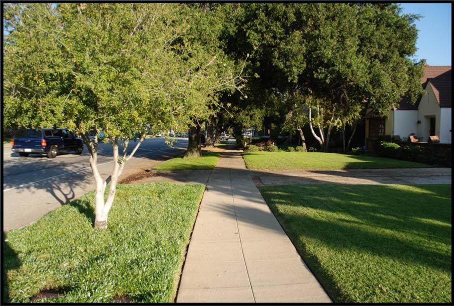
30 Case Study Road Diet Case Study Road Diet 30
 Pedestrian LOS improved (+) Bicycle overall + Slower motorist speeds (+) More vehicle")
31 Case Study Road Diet The Result: Analysis showed that the road diet will result in minor changes to the transit and motorist mode The pedestrian and bicycle modes will improve between 9% and 20% if the road diet is implemented on this corridor Case Study Road Diet Transit overall + Motorist speed decreased (-) Pedestrian LOS improved (+) Bicycle overall + Slower motorist speeds (+) More vehicle volume in adjacent lane (-) Exclusive bike lane (+) Pedestrian overall + More vehicles in lane nearest pedestrians (-) Increased space between motorist and pedestrian (+) Slower motorist speeds (+) 31


32 COMPASS Complete Streets Analysis Complete Streets Who is COMPASS? Why does COMPASS do Complete Streets? The COMPASS Experience with MMLOS What is COMPASS going to do about it? 32

33 COMPASS Evaluate transportation alternatives Develop the region s collective vision MPO Allocate transportation funding resources Other Board Priorities Why does COMPASS do Complete Streets? Federal Policy: Metropolitan Plans Transportation Improvement Program Board Policy: Complete Streets Policy Transportation and Sustainability Plan It is the right thing to do! 33


34 Complete Streets Vision Statement We envision a Treasure Valley where roadways are designed to be safe, efficient, and viable and provide an appropriate balance for all users including, motorists, bicyclists, transit, and pedestrians of all ages and abilities. (emphasis added) Adopted by COMPASS Board on August 17, 2009 Complete Streets Policy National Complete Streets Coalition Complete Streets Policy Analysis 2010 Evaluates over 200 policies Good News 9th Best MPO Complete Streets Policy (348 MPOs nationally) 34 points Bad News 9 th out of 10 for MPOs 34 points out of points for Implementation 34
35 The COMPASS Experience with MMLOS Positives: Standardizes Bike, Pedestrian, and Transit Modes (HCM 2010) Accurate and sensitive to variations in road layout, traffic conditions, and services What-if Scenarios Reporting Features Easy to use GUI/Import Applications The COMPASS Experience with MMLOS Observations: Data Needs Time Consuming Learning Curve for Users/Audience Doesn t consider all roadway designs Import to GIS Function 35


36 State Street Results Auto Bicycle Pedestrian Transit Next Steps Communities in Motion


37 Next Steps Corridor Analysis Next Steps Transportation Improvement Program 37
38 Conclusion Mandate to do Complete Streets Some success and some issues to work through with using MMLOS software for regional corridors Working with COMPASS committees for implementation COMPASS will be using the MMLOS software for Communities in Motion 2040 and other planning activities Thank You! Questions & Discussion Carl Miller Phone: (208) Paul Morrow Phone: (208) Kamala Parks Phone: (510) extension 107 Sonia Hennum Phone: (208)
Complete Street Analysis of a Road Diet: Orange Grove Boulevard, Pasadena, CA
 Complete Street Analysis of a Road Diet: Orange Grove Boulevard, Pasadena, CA Aaron Elias, Bill Cisco Abstract As part of evaluating the feasibility of a road diet on Orange Grove Boulevard in Pasadena,
Multimodal Analysis in the 2010 Highway Capacity Manual
 Multimodal Analysis in the 2010 Highway Capacity Manual It s not just cars anymore! Jamie Parks, AICP HCAT Conference May 9-10, 2011 Multimodal LOS in the 2010 HCM History and background Overview of methods
Emerging Methods for Evaluating Transportation Systems Multimodal LOS and Highway Safety Manual
 Emerging Methods for Evaluating Transportation Systems Multimodal LOS and Highway Safety Manual November 8, 2012 Lake Merritt Tower in Oakland Transportation Education Series 1 Presenters Mark Bowman,
Complete Streets Workshop Follow-up. April 27, 2011 Rockledge City Hall
 Complete Streets Workshop Follow-up April 27, 2011 Rockledge City Hall Agenda Complete Streets draft briefing presentation and sample policy language Share your Complete Streets projects and post workshop
Balancing Operation & Safety for Motorized and Non-Motorized Traffic
 Balancing Operation & Safety for Motorized and Non-Motorized Traffic Brian Willham, PE, PTOE Iowa Director - MOVITE June 30, 2014 Learning Objectives: When & Why should we measure the performance of complete
Waterford Lakes Small Area Study
 Waterford Lakes Small Area Study Existing Traffic Conditions PREPARED FOR: ORANGE COUNTY PUBLIC WORKS DEPARTMENT TRAFFIC ENGINEERING DIVISION ORLANDO, FLORIDA PREPARED WITH: INWOOD CONSULTING ENGINEERS
Purpose and Need. Chapter Introduction. 2.2 Project Purpose and Need Project Purpose Project Need
 Chapter 2 Purpose and Need 2.1 Introduction The El Camino Real Bus Rapid Transit (BRT) Project (Project) would make transit and other transportation improvements along a 17.6-mile segment of the El Camino
AMATS Complete Streets Policy
 AMATS Complete Streets Policy Table of Contents: Section 1. Definition of Complete Streets Section 2. Principles of Complete Streets Section 3. Complete Streets Policy Section 4. Consistency Section 5.
ACTIVE TRANSPORTATION
 ACTIVE TRANSPORTATION Mobility 2040 Supported Goals Improve the availability of transportation options for people and goods. Support travel efficiency measures and system enhancements targeted at congestion
5.0 Roadway System Plan
 Southwest Boise Transportation Study Page 16 5.0 Roadway System Plan The Roadway System Plan outlines roadway improvements in the Initial Study Area. It forecasts future deficiencies on the arterial system,
Multi-modal performance measures: Are we getting an A? Madeline Brozen Herbie Huff UCLA Institute of Transportation Studies Webinar 9/16/14
 Multi-modal performance measures: Are we getting an A? Madeline Brozen Herbie Huff UCLA Institute of Transportation Studies Webinar 9/16/14 Agenda Why measure the street for walking and bicycling? Measures
Implementing Complete Streets in Ottawa. Project Delivery Process and Tools Complete Streets Forum 2015 October 1, 2015
 Implementing Complete Streets in Ottawa October 1, 2015 The Essentials Complete Streets Implementation Framework will become part of the routine delivery of City transportation projects Approach uses every
Performance Criteria for 2035 Long Range Transportation Plan
 Minimizing Impacts on Natural, Historic, Cultural or Archeological Resources 2035 LRTP Weighting Factor: 7% Objective 1.1: Use appropriate planning and design criteria to protect and enhance the built
Living Streets Policy
 Living Streets Policy Introduction Living streets balance the needs of motorists, bicyclists, pedestrians and transit riders in ways that promote safety and convenience, enhance community identity, create
Road Diets FDOT Process
 Florida Department of TRANSPORTATION Road Diets FDOT Process Humberto Castillero, PE, PTOE Roadway Design Office Purpose of Guide Develop a statewide lane elimination review process Balance state & local
Omaha s Complete Streets Policy
 Omaha s Complete Streets Policy (Adopted August 2015) VISION To create great places and enhance our quality of life, the City of Omaha will provide safe, accessible streets for all users. Complete Streets
TRAFFIC IMPACT ANALYSIS
 TRAFFIC IMPACT ANALYSIS FOR THE CHAMPAIGN UNIT#4 SCHOOL DISTRICT PROPOSED HIGH SCHOOL (SPALDING PARK SITE) IN THE CITY OF CHAMPAIGN Final Report Champaign Urbana Urbanized Area Transportation Study 6/24/2014
A Traffic Operations Method for Assessing Automobile and Bicycle Shared Roadways
 A Traffic Operations Method for Assessing Automobile and Bicycle Shared Roadways A Thesis Proposal By James A. Robertson Submitted to the Office of Graduate Studies Texas A&M University in partial fulfillment
Multimodal Level of Service (MMLOS) and the Highway Safety Manual (HSM)
 and the Highway Safety Manual (HSM)") Multimodal Level of Service (MMLOS) and the Highway Safety Manual (HSM) Transportation Education Series July 17, 2012 City of San Luis Obispo Council Chambers Transportation Education Series Presenters
Multimodal Level of Service (MMLOS) and the Highway Safety Manual (HSM) Transportation Education Series July 17, 2012 City of San Luis Obispo Council Chambers Transportation Education Series Presenters
2.0 LANE WIDTHS GUIDELINE
 2.0 LANE WIDTHS GUIDELINE Road Engineering Design Guidelines Version 2.0.1 May 2018 City of Toronto, Transportation Services City of Toronto Page 0 Background In early 2014, Transportation Services initiated
Multimodal Arterial Level of Service
 Multimodal Arterial Level of Service DOUGLAS S. MCLEOD Florida Department of Transportation, USA ABSTRACT The concept of quality of service from a user perspective of a transportation facility or service
Route 7 Corridor Study
 Route 7 Corridor Study Executive Summary Study Area The following report analyzes a segment of the Virginia State Route 7 corridor. The corridor study area, spanning over 5 miles in length, is a multi
9/25/2018. Multi-Modal Level of Service (MMLOS) Bianca Popescu, Transportation Planner
 Bianca Popescu, Transportation Planner") Multi-Modal Level of Service (MMLOS) Bianca Popescu, Transportation Planner 1 What is MMLOS? Is this a nice place to walk? Is this a nice place to bike? Is transit convenient? Bottom line - Are there options
Multi-Modal Level of Service (MMLOS) Bianca Popescu, Transportation Planner 1 What is MMLOS? Is this a nice place to walk? Is this a nice place to bike? Is transit convenient? Bottom line - Are there options
CONNECTING PEOPLE TO PLACES
 CONNECTING PEOPLE TO PLACES 82 EAST BENCH MASTER PLAN 07 Introduction The East Bench transportation system is a collection of slow moving, treelined residential streets and major arteries that are the
REGIONAL BICYCLE AND PEDESTRIAN DESIGN GUIDELINES
 REGIONAL BICYCLE AND PEDESTRIAN DESIGN GUIDELINES November 16, 2011 Deb Humphreys North Central Texas Council of Governments Bicycle and Pedestrian Advisory Committee Snapshot of the Guide 1. Introduction
Planning Guidance in the 2012 AASHTO Bike Guide
 Planning Guidance in the 2012 AASHTO Bike Guide Presentation by: RJ Eldridge Peter Lagerwey August 22, 2012 WEBINAR 2: PLANNING GUIDANCE IN THE 2012 AASHTO BIKE GUIDE Today s Webinar Significant Updates
Defining Purpose and Need
 Advanced Design Flexibility Pilot Workshop Session 4 Jack Broz, PE, HR Green May 5-6, 2010 Defining Purpose and Need In your agency s project development process, when do design engineers typically get
Community Task Force July 25, 2017
 Community Task Force July 25, 2017 Welcome and Introductions Project Partners Regional Transportation District (RTD) Colorado Department of Transportation (CDOT) Denver Regional Council of Governments
San Jose Transportation Policy
 San Jose Transportation Policy Protected Intersections in LOS Policies to Support Smart Growth Presented by: Manuel Pineda City of San Jose Department of Transportation Bay Area Map San Francisco Oakland
Goal 3: Foster an environment of partnerships and collaboration to connect our communities and regions to one another.
 Non-Motorized Transportation Plan (NMTP) Draft Vision, Goal and,, Tri-County Regional Planning Commission (TCRPC) Purpose The purpose of the Tri-County Regional Planning Commission (TCRPC) Non-Motorized
Bicycling and Walking
 Bicycling and Walking Performance Measures Traditional, the new Highway Capacity Manual, and beyond A New Game. Balanced transportation. Multi-modal Complete Streets Livability Sustainable Whatever Economically-Efficient
Washington Metropolitan Area Transit Authority Board Action/Information Summary. MEAD Number:
 Washington Metropolitan Area Transit Authority Board Action/Information Summary Action Information MEAD Number: 100962 Resolution: Yes No TITLE: Bicycle and Pedestrian Access Improvements Study PURPOSE:
Welcome. If you have any questions or comments on the project, please contact:
 Welcome This drop-in public open house is intended to provide information about the Bay Street bike lanes project. This project proposes a dedicated cycling facility along Bay Street between Aberdeen Avenue
City of Novi Non-Motorized Master Plan 2011 Executive Summary
 City of Novi Non-Motorized Master Plan 2011 Executive Summary Prepared by: February 28, 2011 Why Plan? Encouraging healthy, active lifestyles through pathway and sidewalk connectivity has been a focus
US 41 COMPLETE STREETS CORRIDOR PLANNING STUDY from University Parkway to Whitfield Avenue
 41 US 41 COMPLETE STREETS CORRIDOR PLANNING STUDY from University Parkway to Whitfield Avenue EXECUTIVE SUMMARY DRAFT FEBRUARY 2019 Project Overview The US 41 Complete Streets Corridor Planning Study,
T1-A - Service Reduction (Re-sizing)
") Key T1-A Choice A Key T1-B Choice B Key T1-C Choice C Key T1-D Choice D Key T1-E Choice E Key T1-F Choice F Key Choice G T2 T1-A - Service Reduction (Re-sizing) Description This key choice would represent
Key T1-A Choice A Key T1-B Choice B Key T1-C Choice C Key T1-D Choice D Key T1-E Choice E Key T1-F Choice F Key Choice G T2 T1-A - Service Reduction (Re-sizing) Description This key choice would represent
appendix b BLOS: Bicycle Level of Service B.1 Background B.2 Bicycle Level of Service Model Winston-Salem Urban Area
 appendix b BLOS: B.1 Background Winston-Salem Urban Area Bicycle Level of Service Level of Service (LOS) is a framework that transportation professionals use to describe existing conditions (or suitability)
CITY OF COCOA BEACH 2025 COMPREHENSIVE PLAN. Section VIII Mobility Element Goals, Objectives, and Policies
 CITY OF COCOA BEACH 2025 COMPREHENSIVE PLAN Section VIII Mobility Element Goals, Objectives, and Policies Adopted August 6, 2015 by Ordinance No. 1591 VIII MOBILITY ELEMENT Table of Contents Page Number
TRAFFIC IMPACT STUDY CRITERIA
 Chapter 6 - TRAFFIC IMPACT STUDY CRITERIA 6.1 GENERAL PROVISIONS 6.1.1. Purpose: The purpose of this document is to outline a standard format for preparing a traffic impact study in the City of Steamboat
Complete Streets: Planning, Policy & Performance
 Complete Streets: Planning, Policy & Performance Tell Us About Your CS Experiences Successes Hardships Funding Politics Safety Not every street needs to be complete, but every mode needs a complete network.
How To Encourage More Efficient Transportation in Brazilian Cities
 How To Encourage More Efficient Transportation in Brazilian Cities Todd Litman Victoria Transport Policy Institute Presented Seminar on Discouraging The Use Of Cars São Paulo, Brazil 3 September 2013 Creating
This document may be reprinted or extracted without permission, provided credit to the City of Pasadena Department of Transportation
 TRANSPORTATION IMPACT ANALYSIS CURRENT PRACTICE & GUIDELINES Prepared by: Transportation Complete Streets Division Department of Transportation 20150925 This document may be reprinted or extracted without
Chapter 7: Six-Step Implementation Process
 Chapter 7: Six-Step Implementation Process The purpose of this chapter is to explain how the perspectives of all stakeholders interested in or affected by existing or future streets can be incorporated
Agenda. Overview PRINCE GEORGE S PLAZA METRO AREA PEDESTRIAN PLAN
 PRINCE GEORGE S PLAZA METRO AREA PEDESTRIAN PLAN May 28, 2008 Agenda Welcome and introductions Project overview and issue identification Planning context and strengths Design challenges and initial recommendations
On Road Bikeways Part 1: Bicycle Lane Design
 On Road Bikeways Part 1: Bicycle Lane Design Presentation by: Nick Jackson Bill Schultheiss, P.E. September 04, 2012 FOLLOW THE CONVERSATION ON TWITTER Toole Design Group is live tweeting this webinar
CITY OF BLOOMINGTON COMPLETE STREETS POLICY
 CITY OF BLOOMINGTON COMPLETE STREETS POLICY POLICY OBJECTIVE: The City of Bloomington will enhance safety, mobility, accessibility and convenience for transportation network users of all ages and abilities,
Bellevue Transportation: Challenges, Opportunities and Priorities Bellevue Downtown Association September 20, 2018
 Bellevue Transportation: Challenges, Opportunities and Priorities Bellevue Downtown Association September 20, 2018 Dave Berg Transportation Director City of Bellevue Traffic, traffic and more traffic!
City of Ottawa s Complete Streets Approach to Transportation Projects
 City of Ottawa s Complete Streets Approach to Transportation Projects Presentation to Stakeholders Date: May 5, 2015 Presentation Overview Purpose of the study Proposed definition of Complete Streets for
BICYCLE LEVEL OF SERVICE for URBAN STREETS. Prepared by Ben Matters and Mike Cechvala. 4/16/14 Page 1
 BICYCLE LEVEL OF SERVICE for URBAN STREETS Prepared by Ben Matters and Mike Cechvala 4/16/14 Page 1 Introduction The methodology used for the Bicycle (BLOS) analysis is from the Highway Capacity Manual
4. ENVIRONMENTAL IMPACT ANALYSIS 9. TRANSPORTATION AND TRAFFIC
 4. ENVIRONMENTAL IMPACT ANALYSIS 9. TRANSPORTATION AND TRAFFIC 4.9.1 INTRODUCTION The following section addresses the Proposed Project s impact on transportation and traffic based on the Traffic Study
Proposed. City of Grand Junction Complete Streets Policy. Exhibit 10
 Proposed City of Grand Junction Complete Streets Policy Exhibit 10 1 City of Grand Junction Complete Streets Policy Vision: The Complete Streets Vision is to develop a safe, efficient, and reliable travel
Vision: Traditional hamlet with an attractive business/pedestrian friendly main street connected to adjacent walkable neighborhoods
 N D. Focus Area II Vision: Traditional hamlet with an attractive business/pedestrian friendly main street connected to adjacent walkable neighborhoods Transit Road Focus Area II is located in the Hamlet
Bus Rapid Transit on Silicon Valley s El Camino Real: Working Together to Create a Grand Boulevard Steven Fisher
 Bus Rapid Transit on Silicon Valley s El Camino Real: Working Together to Create a Grand Boulevard Steven Fisher Senior Transportation Planner Santa Clara Valley Transportation Authority San Jose, CA How
City of Wayzata Comprehensive Plan 2030 Transportation Chapter: Appendix A
 A1. Functional Classification Table A-1 illustrates the Metropolitan Council s detailed criteria established for the functional classification of roadways within the Twin Cities Metropolitan Area. Table
REVIEW OF LOCAL TRAFFIC FLOW / LONG RANGE PLANNING SOLUTIONS STUDY
 ITEM Town of Atherton TRANSPORTATION COMMITTEE STAFF REPORT TO: FROM: MEMBERS OF THE COMMITTEE ROBERT OVADIA, PUBLIC WORKS DIRECTOR DATE: FEBRUARY 12, 2019 SUBJECT: REVIEW OF LOCAL TRAFFIC FLOW / LONG
We believe the following comments and suggestions can help the department meet those goals.
 The Honorable Secretary Anthony Foxx The Secretary of Transportation United States Department of Transportation 1200 New Jersey Avenue, SE Washington, DC 20590 August 30, 2013 Dear Secretary Foxx, Thank
Chapter 2. Bellingham Bicycle Master Plan Chapter 2: Policies and Actions
 Chapter 2 Bellingham Bicycle Master Plan Chapter 2: Policies and Actions Chapter 2: Policies and Actions The Bicycle Master Plan provides a road map for making bicycling in Bellingham a viable transportation
APPENDIX A: Complete Streets Checklist DRAFT NOVEMBER 2016
 APPENDIX A: Complete Streets Checklist DRAFT NOVEMBER 2016 Complete Streets Checklist MetroPlan Orlando s Complete Streets Checklist is an internal planning tool for staff to further implementation of
TOWN OF PORTLAND, CONNECTICUT COMPLETE STREETS POLICY
 TOWN OF PORTLAND, CONNECTICUT COMPLETE STREETS POLICY I. VISION, GOALS & PRINCIPLES VISION To improve the streets of Portland making them safer and more accessible for all users including pedestrians,
FOR INFORMATION ONLY
 9 Date: August 6, 2012 Current Meeting: August 16, 2012 Board Meeting: September 6, 2012 BOARD MEMORANDUM TO: THROUGH: FROM: SUBJECT: Santa Clara Valley Transportation Authority Congestion Management Program
Preliminary Transportation Analysis
 Preliminary Transportation Analysis Goals of a Robust, Multimodal Transportation Network Safe Accessible/Connected Efficient Comfortable Context-Sensitive Motor Vehicle: Continue to analyze the data to
Overview. Illinois Bike Summit IDOT Complete Streets Policy Presentation. What is a Complete Street? And why build them? And why build them?
 Overview Illinois Bike Summit IDOT Complete Streets Policy Presentation Aren Kriks, P.E. District One Bicycle Coordinator and Bureau of Programming Project Engineer History of Complete Streets IDOT Policy
Why are we still talking about Complete Streets?
 Why are we still talking about Complete Streets? Jeremy R. Klop, AICP Complete Streets and Capital Projects Session March 1, 2013 Public Works Officers Institute League of California Cities Conference,
6 Screen 3 Analysis and Results
 6 Screen 3 Analysis and Results Introduction This chapter documents the results of the Screen 3 (final) evaluation and screening process. This chapter contains the following elements: Description of the
HIGHWAY CAPACITY MANUAL
 HISTORY OF THE HIGHWAY CAPACITY MANUAL TexITE - Houston Chapter November 10, 2010 Michael Y. Ereti City of Houston Department of Public Works & Engineering THE NEW GUY (Michael Ereti) Consultant (10 years)
Develop a Multi-Modal Transportation Strategy (Theme 6)
") DEVELOP A MULTI-MODAL TRANSPORTATION STRATEGY (THEME 6) WHY IS THIS THEME ADDRESSED? Develop a Multi-Modal Transportation Strategy (Theme 6) Statement of Ideal Reduce resident and visitor reliance on single
DEVELOP A MULTI-MODAL TRANSPORTATION STRATEGY (THEME 6) WHY IS THIS THEME ADDRESSED? Develop a Multi-Modal Transportation Strategy (Theme 6) Statement of Ideal Reduce resident and visitor reliance on single
6.0 PEDESTRIAN AND BICYCLE FACILITIES 6.1 INTRODUCTION 6.2 BICYCLE DEMAND AND SUITABILITY Bicycle Demand
 6.0 PEDESTRIAN AND BICYCLE FACILITIES 6.1 INTRODUCTION Bicycle and pedestrian travel along and in the vicinity of the corridor is part of the vision of Somerset and Hunterdon counties and the integrated
Executive Summary Route 30 Corridor Master Plan
 Route Corridor Master Plan Project Overview The Route Corridor Master Plan is a coordinated multimodal transportation and land use plan for the entire stretch of Route through East Whiteland Township,
Beach Cities Living Streets Design Manual and Aviation Boulevard Multimodal Corridor Plan
 Beach Cities Living Streets Design Manual and Aviation Boulevard Multimodal Corridor Plan AGENDA 1 Introductions & Project Scope 2 Public Outreach Recap 3 Living Streets Design Manual 4 Aviation Boulevard
Clackamas County Comprehensive Plan
 ROADWAYS The County s road system permits the movement of goods and people between communities and regions, using any of a variety of modes of travel. Roads provide access to virtually all property. They
City of Elizabeth City Neighborhood Traffic Calming Policy and Guidelines
 City of Elizabeth City Neighborhood Traffic Calming Policy and Guidelines I. Purpose: The City of Elizabeth City is committed to ensure the overall safety and livability of residential neighborhoods. One
The current document is revised based on the comments received on:
 General Overview 1 Introduction Over the last several years, the Waterford Lakes area has experienced increased congestion due to a substantial increase in residential and commercial development. The current
Cycle Track Design Best Practices Cycle Track Sections
 Design Best Practices Sections It is along street segments where the separation and protection methods of cycle tracks offer more comfort than conventional bicycle lanes, and are more attractive to a wide
Operational Comparison of Transit Signal Priority Strategies
 Operational Comparison of Transit Signal Priority Strategies Revision Submitted on: November, 0 Author: Adriana Rodriguez, E.I Assistant Engineer Parsons Brinckerhoff 0 South Orange Avenue, Suite 00 Orlando,
DEPARTMENT OF ENVIRONMENTAL SERVICES. North Harrison Street (Lee Highway to Little Falls Road) Comparative Analysis. Prepared for:
 Comparative Analysis. Prepared for:") DEPARTMENT OF ENVIRONMENTAL SERVICES North Harrison Street (Lee Highway to Little Falls Road) Comparative Analysis Prepared for: Arlington County Department of Environmental Services 2100 Clarendon Boulevard,
DEPARTMENT OF ENVIRONMENTAL SERVICES North Harrison Street (Lee Highway to Little Falls Road) Comparative Analysis Prepared for: Arlington County Department of Environmental Services 2100 Clarendon Boulevard,
Exhibit 1 PLANNING COMMISSION AGENDA ITEM
 Exhibit 1 PLANNING COMMISSION AGENDA ITEM Project Name: Grand Junction Circulation Plan Grand Junction Complete Streets Policy Applicant: City of Grand Junction Representative: David Thornton Address:
SR 693 (Pasadena Avenue) Corridor Study from Shore Drive South to 66 th Street
 Corridor Study from Shore Drive South to 66 th Street") Welcome and Introduction Sign-in and comment sheets Restrooms and exits Meeting agenda and timeline Meeting goals / expectations Provide input to guide study recommendations Actively participate throughout
Welcome and Introduction Sign-in and comment sheets Restrooms and exits Meeting agenda and timeline Meeting goals / expectations Provide input to guide study recommendations Actively participate throughout
Young Researchers Seminar 2011
 Young Researchers Seminar 2011 Young Researchers Seminar 2011 DTU, Denmark, 8 10 June, 2011 DTU, Denmark, June 8-10, 2011 Methods for assessing the pedestrian level of service: International experience
SECTION 1 - TRAFFIC PLANNING
 SECTION 1 - TRAFFIC PLANNING 1.1 TRAFFIC OPERATIONS 1.1.1 Roadway Functional Classification The Multnomah County Comprehensive Framework Plan s Policy 34: Trafficways and the Functional Classification
Presentation to NCDOT s Complete Streets Advisory Group. June 22, 2010 Charlotte, NC
 Presentation to NCDOT s Complete Streets Advisory Group June 22, 2010 Charlotte, NC Presenters Norm Steinman, AICP Manager, CDOT Planning and Design Division Mike Davis, PE Manager, CDOT Development Services
PRINCE GEORGE S PLAZA METRO AREA PEDESTRIAN PLAN
 PRINCE GEORGE S PLAZA METRO AREA PEDESTRIAN PLAN May 28, 2008 Agenda Welcome and introductions Project overview and issue identification Planning context and strengths Design challenges and initial recommendations
Goodlettsville Bicycle and Pedestrian Plan Executive Summary
 Goodlettsville Bicycle and Pedestrian Plan July 2010 In Cooperation with the Nashville Area Metropolitan Planning Executive Organization Summary Introduction Progressive and forward thinking communities
Memorandum. Purpose: To update the MPO CTAC on the status of the LRTP scenario evaluation process.
 Charlottesville-Albemarle Metropolitan Planning Organization POB 1505, 401 E. Water St, Charlottesville, VA 22902 www.tjpdc.org (434) 979-7310 phone info@tjpdc.org email Memorandum To: MPO CTAC From: Wood
Bicycle Master Plan Goals, Strategies, and Policies
 Bicycle Master Plan Goals, Strategies, and Policies Mobilizing 5 This chapter outlines the overarching goals, action statements, and action items Long Beach will take in order to achieve its vision of
Arlington s Master Transportation Plan
 Arlington s Master Transportation Plan The Master Transportation Plan (MTP) Adopted in eight parts Goals & Policies element and MTP Map adopted in 2007 Bicycle, Pedestrian and Demand and Systems Management
Corpus Christi Metropolitan Transportation Plan Fiscal Year Introduction:
 Introduction: The Safe, Accountable, Flexible, Efficient Transportation Equity Act: A Legacy for Users (SAFETEA-LU) has continued the efforts started through the Intermodal Surface Transportation Efficiency
Active Transportation Facility Glossary
 Active Transportation Facility Glossary This document defines different active transportation facilities and suggests appropriate corridor types. Click on a facility type to jump to its definition. Bike
EXECUTIVE SUMMARY. Vision
 Vision Walking and bicycling in Salt Lake City will be safe, convenient, comfortable, and viable transportation options that connect people to places, foster recreational and economic development opportunities,
Presentation Starts at 5:30 PM
 Presentation Starts at 5:30 PM Public Meeting #1 September 22, 2016 Purpose of Study Conceptual Complete Streets Study on South Carson Street 5 th Street to Roland Drive Approximately 2.5 miles Consider
Columbia Pike Implementation Team (CPIT) Meeting
 Meeting") Columbia Pike Implementation Team (CPIT) Meeting November 30, 2010 Agenda Introductions / Purpose of Meeting Review of project goals Multimodal project: 10% street design between the curbs Discussion Multimodal
Columbia Pike Implementation Team (CPIT) Meeting November 30, 2010 Agenda Introductions / Purpose of Meeting Review of project goals Multimodal project: 10% street design between the curbs Discussion Multimodal
University Hill Transportation Study Technical Memorandum Alternatives Modeling and Analysis May 2007
 Technical Memorandum May 2007 Syracuse Metropolitan Transportation Council Edwards and Kelcey with Wallace Roberts and Todd Alta Planning and Design CONTENTS SECTION ONE- INTRODUCTION...1 SECTION TWO-
Planning Study SR 976. Project Advisory Team Meeting May 24, 2017
 ` SR 976 BIRD ROAD/SW 40TH STREET FROM SR 821/HEFT TO SR 5/US-1 Miami-Dade County, Florida FPID No.: 434845-4-22-01 Planning Study Project Advisory Team Meeting May 24, 2017 1 Agenda Introductions Project
Solana Beach Comprehensive Active Transportation Strategy (CATS)
") Solana Beach Comprehensive Active Transportation Strategy (CATS) 3.0 Goals & Policies The Solana Beach CATS goals and objectives outlined below were largely drawn from the Solana Beach Circulation Element
Solana Beach Comprehensive Active Transportation Strategy (CATS) 3.0 Goals & Policies The Solana Beach CATS goals and objectives outlined below were largely drawn from the Solana Beach Circulation Element
INDOT Complete Streets Guideline & Policy
 INDOT Complete Streets Guideline & Policy INTRODUCTION The Complete Streets guidelines build upon multiple efforts and promote a multimodal transportation system that is integrated and sustains land use
LTAP Fact Sheet. Abuzz word among transportation professionals. Kansas. Smarter, Safer Roadways: Road Diets for Rural Communities.
 Spring 2009 Kansas LTAP Fact Sheet A Service of Kansas University Transportation Center for Road, Street & Bridge Agencies Smarter, Safer Roadways: Road Diets for Rural Communities By Mehrdad Givechi,
Complete Streets Training. Georgia Municipal Association June 27, 2016
 Complete Streets Training Georgia Municipal Association June 27, 2016 Overview What are CS? GDOT s Policy Case Study 2 What are Complete Streets? According to the National Complete Streets Coalition, complete
David DiPierro, John Amberson. Steering Committee Meeting #4 Overview
 IBI GROUP 18401 Von Karman Avenue Suite 110 Irvine CA 92612 USA tel 949 833 5588 fax 949 833 5511 ibigroup.com Memorandum To/Attention Steering Committee Members Date February 17, 2016 From IBI Group Project
SANTA CLARA COUNTYWIDE BICYCLE PLAN August 2008
 SANTA CLARA COUNTYWIDE BICYCLE PLAN August 2008 To assist VTA and Member Agencies in the planning, development and programming of bicycle improvements in Santa Clara County. Vision Statement To establish,
Multimodal Level of Service in King County
 Multimodal Level of Service in King County A Guide to Incorporating Alternative Modes of Transportation into Local Jurisdictions Roadway Performance Measurements Made possible by funding from the Department
Technical Memorandum TRAFFIC IMPACT STUDY. RIDLEY ROAD CONVENIENCE STORE Southampton County, VA. Prepared for: Mr. David Williams.
 Technical Memorandum TRFFIC IMPCT STUDY RIDLEY ROD CONVENIENCE STORE Southampton County, V Prepared for: Mr. David Williams By: Charles Smith, P.E., PTOE EPR Charlottesville, V July 2014 1 TBLE OF CONTENTS