Principles. 4biii. Good Urban Design
|
|
|
- Ezra Tyler
- 5 years ago
- Views:
Transcription
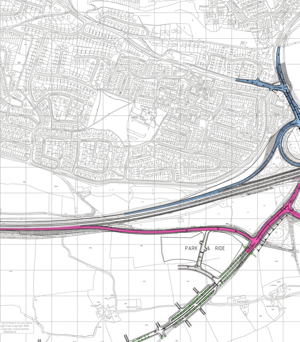
1 Principles Good Urban Design The Sherford approach to the hierarchy of travel modes is fostered and encouraged by a combination of influences. These are as follows, described in further detail below: Town layout, to reduce trip distance between home and community facilities, to encourage walking Good urban design, to encourage walking and cycling Integrated land use planning, to encourage live/work/play within the town Introduction of a High Quality Public Transport (HQPT) service through the centre of the town Incentives to reduce car use and promote non-car alternatives Early delivery of non-car options This blend is particularly effective because Sherfod is a brand new community and there are few existing constraints. All of these influences will be put in place from the outset in order to establish sustainable patterns of behaviour. These influences are discussed separately below. Town Layout The physical layout of the town is a gridded network of streets which minimise walking distances between home, workplace, schools, shops and other daily needs. This spatially balanced layout will eliminate the need to make routine trips of the length that demand motorised travel and allow the maximum possible number of trips to be made on foot. The permeable network disperses all modes of traffic throughout the whole grid, allowing non-car users to reclaim the street. While the Main Street is the key artery through Sherford, parallel routes to the north and south provide opportunities for dispersal of movement and activity within Sherford. The placing of a Park and Ride site at the northern end of Sherford near Deep Lane junction on the A38 will make it possible for Plymouth bound car trips to stop short of the town and continue their journey by HQPT. This will make a substantial contribution to minimising the volume of through traffic both within Sherford, on the A38 and other city centre routes. The quality of streets and vibrancy of the public realm and the ease of access to public transport reinforces the defined Sherford hierarchy. Pedestrians and cyclists will have a sense of freedom and will feel safer and more secure. The HQPT system will have dedicated sections at certain key points where the flow of the bus will be managed to give priority over other motorised vehicles. The relative performance of the bus over the car will encourage bus patronage and make people think harder before getting in their car. Public transport stops will be sheltered, secure, well maintained and will carry real time bus information displays. The design of the Main Street will inhibit traffic speed. Cars can pass but their progress will be punctuated by the imperative to give way to other modes in the hierarchy. All streets will be laid out and designed such that speed limits are self-enforcing, for example using building deflections, limiting visibility and changes to materials. Parking for bicycles at all attractors and at home will be generous, convenient and secure. Parking for cars will be adequate but not excessive and where possible a managed system will be operated that allows off-street car parks to be shared by different uses, for example leisure and office or residential and office. Short term parking on the Main Street will be provided to afford casual access to retail facilities by passing customers and will also add edge friction that will slow passing traffic. Integrated Land Use Planning This planning application represents a carefully calculated balance and mix of residential and other uses, such that daily and weekly needs are catered for within the town. As the demand for transport is derived from the demand to carry out other activities this should contribute to a significant reduction in the need to make long distance trips outside the community. The effect of this internalisation of trip making is addressed and quantified in the TA. 4biii 181
2 Incentives to Reduce Car Use A wide range of sustainability incentives, in addition to the investment in infrastructure, will complement and reinforce the planning, layout and design influences. Implementation, monitoring and review of these and other incentives will be carried out by the Community Trust which will have a specific role to promote sustainable travel. The Community Trust will be highly accessible, located in the Town Hall in the middle of the High Street. In this respect, the Community Trust will also have responsibility for monitoring the community s interest with regard to public transport. A cross section of the initiatives that will be considered and introduced includes: Marketing and promotional campaigns aimed at raising awareness and understanding of sustainable modes and the impact of car travel A Sherford travel web site providing information on transport options and benefits for all journeys Workplace and residential travel plans Working with the relevant operators to establish travel plans for other attractors such as Schools, community and leisure facilities and the Health Centre Service delivery plans for retail outlets A car club to promote shared use and hire. which will be operated from a central office facility with provision for storage, parking and customer collection / return. The car club should allow members to book via telephone or internet and collect / return across the development site via a smart card access system. A wide range of vehicles should be made available to reflect the needs of the community. A car share network Cycle training and a cycle users group A free bicycle will be gifted to buyers of all Phase 1 dwellings These will be co-ordinated with existing community based transport services. Early Delivery This powerful combination of influences will be introduced from the very outset of the occupa- tion of Sherford. The conventional way in which phased development is introduced is to wait until it reaches certain levels of critical mass before it triggers the introduction of various services and infrastructure. This means that early occupiers and users of the development have to rely on car based modes for daily activities and travel arrangements and are reluctant to subsequently change to more sustainable modes. This will not be the case at Sherford. It is intended that the Main Street, Park and Ride, public transport link, Community Trust, commercial and community facilities will be delivered within Phase 1 of Sherford. For full details of phasing, please see the Phasing Strategy. Cycling Figure 2 shows the proposed cycle network within the urban area and Figure 3 illustrates typical sections of the Northern and Southern Avenue, which incorporate a signed segregated cycle route. The fundamental starting point for the Sherford Cycling Strategy is that all streets within the community are suitable for cycling. This approach is reinforced by using the layout, in terms of buildings, car parking and landscape, to keep traffic at speeds of 20mph or less, encouraging cyclists to share road space with vehicular traffic because of reduced speeds. The Town Plan is designed as a permeable network of streets in a deformed grid formation provides a choice of routes to every destination. This form of more permeable network encourages cycling by providing the cyclist with a series of alternative routes which they choose to navigate depending upon traffic conditions, topography and cycling ability. Cycling throughout the development will also be encouraged in a number of other ways: Interchange with public transport will be encouraged, particularly at HQPT stops by the provision of secure covered cycle parking facilities Cycle parking will be provided in overlooked and accessible locations in the main public areas. As a general rule 1 in 10 parking spaces could be allocated for cycle parking 182

3 Secure lock up storage facilities for bicycles will be provided for each dwelling, in accordance with EcoHomes best practice criteria Cycling will be promoted through sales literature for the dwellings, co-ordinated subsequent cycling information to residents and free bicycles for buyers of all Phase 1 dwellings Workplaces will promote travel plans which will have a high emphasis on cycling. This will include secure storage, changing and showering facilities at each venue, in accordance with BREEAM best practice criteria School travel plans will manage and monitor safe routes to school for cyclists Provide cycle storage The topography of the site is, for Devon, comparatively friendly for cyclists with a significant proportion of the urban area on slopes of 5% or less and the majority (92%) of 10% or less. The philosophy agreed between the local planning and highway authorities and Red Tree has been to minimise street furniture and signage to enhance the quality of the public realm. It is accepted that some cyclists, particularly children, may not be comfortable using busier streets therefore the Sherford Cycling Strategy provides dedicated routes to schools and leisure facilities. The National Cycle Network (NCN) 2 route links Plymouth to Totnes mainly on lightly trafficked roads, minor lanes or traffic free sections. While it is considered that the permeable grid of streets as a whole allows for any series of routes the Sherford, depending on your cycling purpose and ability, it is proposed to continue the NCN2 route through the Northern Avenue on segregated cycle lanes. The Northern Avenue will provide direct access to employment areas, sporting facilities and the Park and Ride interchange. The multiple connections between the permeable network and Northern Avenue will provide cyclists with the opportunity to easily gain access to the main commercial centres and educational areas. Additional segregated cycle facilities will be provided to enable the cycle route on Northern Avenue to be connected to the existing NCN2 route on the northern side of Deep Lane, and to Vinery Lane. This design will enable a direct segregated connection to be provided from the National Cycle Route Network 2 at Deep Lane to the National Cycle Route Network 2 on the north side of the A379 in the future if Vinery Lane and Portway Close are upgraded to accommodate a cycle route, though this specific upgrade will not be delivered by Sherford. Cyclists can however choose to continue around the rural edge route to connect via the valley to the NCN2 on the north side of the A379. The Town is not only fully permeable, but the cycle routes have also been designed to allow circumnavigation of the whole urban form. High Quality Public Transport A fundamental element of the sustainable movement strategy is the implementation of a High Quality Public Transport (HQPT) service linking the proposed Park and Ride facility at Deep Lane to Plymouth City Centre. The HQPT is a bus based system which allows high quality, high capacity vehicles to run at short intervals (up to one per five minutes at peak times) on a regular basis. The associated infrastructure and technology will ensure that the service timetable will be extremely reliable. The Park and Ride Interchange provides the commercial basis for the early delivery of the HQPT system through Sherford. It will be provided within Phase 1 and will create capacity for 1,000 vehicles, and allow for future expansion. High Quality Public Transport 4biii 183

4 Reproduced from Ordnance Survey digital map data Crown copyright All rights reserved. Licence number Figure 2 Proposed Internal Cycle Route Network 184

5 The interim solution for the onward connection through to Plymouth City Centre will be via Stanborough Cross westwards along the A379. PCC seeks to secure a permanent segregated route from Haye Road westwards through Moorcroft Quarry along the route of the disused railway line. The junction at Haye Road is designed to facilitate a connection into Moorcroft Quarry south of the proposed Main Street junction. The provision of substantial infrastructure improvements along the A379 Corridor will allow significantly faster journey times than by car. 4biii It is intended that the HQPT will link the Park and Ride Interchange site to Plymouth via the Main Street to the A379 corridor into the City Centre. The Eastern Corridor Study, endorsed by Plymouth City Council (PCC), has identified the preferred alignment for the connection for the Main Street immediately north of Elburton. Within Sherford three stops will be provided on the Main Street at the neighbourhood centres, with an additional stop at the Park and Ride. The HQPT has been deliberately integrated into the Main Street in order to capitalise on the high levels of activity and accessibility. The Main Street has been designed to prioritise the HQPT buses whilst maintaining it as a key street for other users. The commercial vitality and vibrancy in the heart of the community is a major contributor to the patronage of the HQPT. Reciprocally waiting passengers have quick and direct access to Sherford facilities on the Main Street. The HQPT buses will run with vehicular traffic for much of the length of the Main Street and will be given priority at each of the signalised junctions. Local network compatible transponders on board the vehicles will activate the signals in advance, providing a green wave of lights for the bus, allowing the bus through each set of signals without stopping. In addition, a segregated element of centre running has been provided through the High Street to allow buses faster passage through the busiest elements of the town centre. In the early, less busy years, this centre running area will be set aside for car parking to stimulate early commercial and retail activity on the High Street. 185
6 Highways The TA and the TA Addendum have identified a number of proportionate upgrades to the existing highway network required to provide capacity for the external traffic generated by Sherford. These improvements have been split into two elements: a. from Deep Lane junction to Plymouth city centre along the A379 corridor b. other offsite highway links to neighbouring communities The generation and distribution of traffic from Sherford is shown in Figure 3. a. Deep Lane junction to Plymouth city centre along the A379 corridor Development plan policy requires the provision of a road link between the A38 and the A379. Sherford is ideally situated to connect to the strategic highway network and achieve this link requirement early in the development. A38 and Deep Lane Figure 3 Cycle Routes, Typical Street Sections The A38 including Deep Lane junction is part of the UK s Strategic Road Network and is under the jurisdiction of the Highways Agency, who control the country s Motorways and Trunk Roads. The A38 itself is classified as an Expressway, which has a status between a normal dualled Trunk Road and a Motorway. The TA and TA Addendum have identified that improvements to the existing capacity of Deep Lane junction are required to facilitate the traffic generated by Sherford. These improvements are proposed in three stages (see Figure 4): Stage 1: Initially, the existing priority junction between the westbound slip roads and Deep Lane will be upgraded to a signalised layout in order to provide sufficient capacity for the Sherford construction traffic. In addition, the existing spiral westbound on slip will be closed and replaced with a new on slip that will provide access to the Park and Ride Interchange and Phase 1 of the development. The junction between the new westbound on slip and the A38 will be formed using a lane gain with ghost island merge. Furthermore, the existing junction between the A38 and the existing westbound off slip will be 186
7 upgraded to a ghost island diverge with lane drop, and the width of the westbound diverge sliproad will be increased to accommodate two 3.65m wide lanes bounded by 1.0m hardstrips. The proposed improvements to the westbound diverge are required firstly to ensure that its layout will be compatible with the layout of the new westbound merge, and secondly to provide sufficient capacity to accommodate the traffic generated by the subsequent phases of the Sherford development. The existing junction between the eastbound slip roads and Deep Lane has recently been upgraded from a priority arrangement to a signalised layout, and this junction improvement will be capable of accommodating the Sherford construction traffic; therefore this junction will not need to be upgraded further as part of the Stage 1 improvements. Stage 2: The existing signalised junction between the eastbound slip roads and Deep Lane will be upgraded to a more complex signalised arrangement incorporating an increased number of lanes. In addition, the existing Ridgeway Roundabout, which is situated on the north side of the A38 will be upgraded to a signalised layout. The proposed upgrades to these two junctions are required in order to accept all of the traffic from the subsequent phases of the Sherford development. In addition, the existing junctions between the A38 and the eastbound diverge and merge slip roads will be upgraded to incorporate a ghost island with lane drop and lane gain, respectively. The width of the merge and diverge slip roads will also be increased to accommodate two 3.65m wide lanes bounded by 1.0m hardstrips. The proposed improvements to the eastbound slip roads are required to provide sufficient capacity to accommodate the traffic generated by the subsequent phases of the Sherford development. Stage 3: Prior stages have been designed to accommodate further improvements to provide capacity for background growth and a possible extension to Langage Business Park which can be added to this layout, as required, in the future. Haye Road and A379 at Stanborough Cross The southern end of the Main Street connects to the existing highway network at Haye Road along the southern edge of Hazeldene Quarry (see Figure 5). The junction is controlled by traffic signals in order to provide priority for the HQPT bus in both directions. In the interim scheme HQPT vehicles will be able to reach the Stanborough Cross junction ahead of the platoon of traffic leaving the Haye Road lights. The Stanborough Cross junction itself is upgraded from the current roundabout to a signalized layout, with widening provided on all entry arms (see Figure 6). The existing junction layout currently has insufficient capacity at peak times. Improvements could be phased but it may be appropriate that this scheme is delivered at an early stage. In order to satisfy planning policy objectives set by the North Plymstock AAP and developments beyond Sherford, this connection must be adaptable to provide an HQPT bus link to the west. The design of the Haye Road junction accommodates this link by means of a bus only signalised right turn facility on Haye Road approximately 100m south of the proposed Main Street junction with Haye Road. A379 Corridor from Stanborough Cross to Laira Bridge Much of this length of road is dual carriageway reduced to one lane in each direction by painting out a significant length of the inside lane. These measures were introduced by Plymouth City Council in order to reduce traffic speeds and increase safety for pedestrians and cyclists in particular. It is intended to use these painted out sections for dedicated HQPT lanes and additional capacity at Colesdown Hill roundabout. See Figures 7 and 8. Pomphlett Road roundabout currently suffers from insufficient capacity, particularly in the morning peak period. It is proposed that the Plymstock Quarry development will have an access close to the junction and associated improvements will be required. The Sherford TA anticipates that these improvements will come forward in a similar timescale to Sherford. The upgraded roundabout will have sufficient capacity to accept the additional traffic from Plymstock Quarry and Sherford. 4biii 187
8 188
9 4biii Figure 4 Deep Lane Junction Staging Diagram 189
10 Figure 5 Haye Road Proposed Layout 190
11 4biii Figure 6 Stanborough Cross Proposed Layout 191
12 192
44biii. Introduction. 182 Movement and Transport
 44biii movement and transport Introduction The Movement and Transport Strategy for Sherford is an essential component of the vision for a sustainable town. The demand for travel that will arise from the
10 SHERFORD Town Code
 Key Fixes (Ref: Masterplan Book, section 4a. Land Use Budget and Key Fixes ) The Town Plan designs and allocates buildings, streets and spaces as accurately as possible in the understandable absence of
DRAFT for a State Policy for Healthy Spaces and Places
 DRAFT for a State Policy for Healthy Spaces and Places 1 DRAFT State Policy for Healthy spaces and Places 1. Purpose To encourage the use and development of land that builds healthy communities through
21.07 TRANSPORT CONNECTIVITY AND INFRASTRUCTURE
 21.07 TRANSPORT CONNECTIVITY AND INFRASTRUCTURE 21.07-1 Connectivity and Choice Transport connectivity and mode choice are critical to achieving productive, sustainable and socially just cities. Travel
Strategy for Walking & Cycling Action Plan
 Strategy for Walking & Cycling Action Plan To achieve higher levels of walking and cycling activity, the destinations which people access have to be available within suitable distances and designed to
LEA BRIDGE ROAD - A STREET FOR EVERYONE Public consultation document
 LEA BRIDGE ROAD - A STREET FOR EVERYONE Public consultation document TELL US Bakers Arms to Leyton Green Road (Section D, E, F) Leyton Green Road to Whipps Cross Roundabout (Section G) YOUR VIEWS www.enjoywalthamforest.co.uk
TRANSPORT AND MOVEMENT
 TRANSPORT AND MOVEMENT Movement Strategy Public Transport Cycling and Walking Road Network Parking Standards Transport Impact Assessments Traffic Management Policies DRAFT POOLBEG PLANNING SCHEME Movement
9. Parking Supporting Statement
 9. Parking Supporting Statement Content 1. Setting the Scene 2. Vision 3. Parking and the Shared Priorities 4. Issues 5. Delivery Programme in the first Plan Period 2001/02 2005/06 6. Good Practice 7.
March Maidstone Integrated Transport Strategy Boxley Parish Council Briefing Note. Context. Author: Parish Clerk 2 March 2016
 Context. Author: Parish Clerk 2 The Draft Integrated Transport Policy (DITS) sets out a vision and objectives, and identifies a detailed programme of interventions to support the Maidstone Borough Local
A127/A130 Fairglen Interchange Improvement Schemes. Information Leaflet February 2017
 A127/A130 Fairglen Interchange Improvement Schemes Information Leaflet February 2017 1 2 Foreword By Councillor Kevin Bentley Essex is continuing to grow as a vibrant economic hub and as a fantastic place
Cycle traffic and the Strategic Road Network. Sandra Brown, Team Leader, Safer Roads- Design
 Cycle traffic and the Strategic Road Network Sandra Brown, Team Leader, Safer Roads- Design Highways England A Government owned Strategic Highways Company Department for Transport Road Investment Strategy
MARKHOUSE ROAD IMPROVEMENTS
 MARKHOUSE ROAD IMPROVEMENTS www.enjoywalthamforest.co.uk Waltham Forest is changing and we want you to be part of it. Thanks to a funding pot of 27million from Transport for London, we re delivering the
High frequency bus services operating to Little Island; Creation of a new Park and Ride site and train station at North Esk;
 Cork County Council 7 th December 2018 Dear Adrian O Neill (aoneill@jbbarry.ie) The Transport and Mobility Forum, Cork (TMF) is a representative group of organisations who have a common interest in sustainable
Douglas Land Use and Transportation Strategy (DLUTS) Summary. August 2013
 Summary. August 2013") Douglas Land Use and Transportation Strategy (DLUTS) Summary August 2013 Background Douglas is a large and popular residential suburb of approximately 30,000 persons on the periphery of Cork City along
Douglas Land Use and Transportation Strategy (DLUTS) Summary August 2013 Background Douglas is a large and popular residential suburb of approximately 30,000 persons on the periphery of Cork City along
London Cycle Network Annual Report 2000
 London Cycle Network Annual Report 2000 A cycle network for London by 2005 A cycle network for London by 2005 The London Cycle Network will: provide local links between residential neighbourhoods, railway
Public Consultation on Braintree Integrated Transport Package (ITP) HAVE YOUR. Consultation open from 24 September to 5 November 2018 SAY
 HAVE YOUR. Consultation open from 24 September to 5 November 2018 SAY") Public Consultation on Braintree Integrated Transport Package (ITP) HAVE YOUR SAY Consultation open from 24 September to 5 November 2018 Contents Introduction 3 Background 4 Springwood Drive Roundabout
Public Consultation on Braintree Integrated Transport Package (ITP) HAVE YOUR SAY Consultation open from 24 September to 5 November 2018 Contents Introduction 3 Background 4 Springwood Drive Roundabout
1.5 On this basis it is fundamental that the Transport Strategy for the site focuses on the following key criteria,
 1.0 Introduction 1.1 The Transport Assessment has been prepared on behalf of Eon and Roger Bullivant Ltd in respect of the proposed mixed use sustainable urban extension of Drakelow Park. 1.2 The methodology
2. Context. Existing framework. The context. The challenge. Transport Strategy
 Transport Strategy Providing quality connections Contents 1. Introduction 2. Context 3. Long-term direction 4. Three-year priorities 5. Strategy tree Wellington City Council July 2006 1. Introduction Wellington
The Cabinet Member for Highways & Streetscene. Aurang Zeb - Head of Highways & Transport
 LONDON BOROUGH OF RICHMOND UPON THAMES Cabinet Member Decision DATE: January 2012 REPORT OF: LEAD OFFICER: SUBJECT: WARDS: The Cabinet Member for Highways & Streetscene Aurang Zeb - Head of Highways &
MILTON ROAD LLF PROJECT UPDATE
 Greater Cambridge City Deal MILTON ROAD LLF PROJECT UPDATE 9 th May 2017 Project objectives Comprehensive priority for buses in both directions wherever practicable; Additional capacity for sustainable
Bristol City Council has produced a draft Bristol Transport Strategy document.
 Bristol Transport Strategy Summary Document Introduction Bristol City Council has produced a draft Bristol Transport Strategy document. The Strategy fills a gap in transport policy for Bristol. We have
North West Non-Technical Summary of the Transport Assessment September 2011
 North West Non-Technical Summary of the Transport Assessment September 2011 Introduction This is a Non-Technical Summary of the findings of the Transport assessment work undertaken for the proposed North
IAN WHITE ASSOCIATES. Crawley Station Gateway Public Realm
 IAN WHITE ASSOCIATES Crawley Station Gateway Public Realm contents 1. objectives & client brief 2. site appraisal 3. best practice guidance 4. design concept 1. objectives & client brief Crawley Train
Design Workshops Summary of all Feedback January 2017
 Histon Road Corridor Design Workshops Summary of all Feedback January 2017 CITY DEAL AND GROWTH Commitment to Growth: Government, County, City and District Emerging Local Plans: 33,000 new homes 45,000
Nottingham Cycle City Frequently Asked Questions
 Nottingham Cycle City Frequently Asked Questions About the scheme How much money is to be spent on cycling? And where is the money from? We have 6.1 million in Growth Fund which we will be investing directly
CUERDEN TRANSPORT PROPOSALS
 1 CUERDEN TRANSPORT PROPOSALS The transport assessment, submitted with the Cuerden development planning application, looks at access to the site and the impact on the local road network in detail. This
E4 Cycle Route Exeter University to Redhayes Bridge. - Recommendations from Exeter Cycling Campaign
 E4 Cycle Route Exeter University to Redhayes Bridge - Recommendations from Exeter Cycling Campaign 1.0 Introduction Exeter Cycling Campaign has prepared this report to provide recommendations for Devon
Frascati Road and Temple Hill Route Improvements. Outline Design Report to Accompany Public consultation
 Frascati Road and Temple Hill Route Improvements Outline Design Report to Accompany Public consultation September 2013 Background: Dún Laoghaire-Rathdown is committed to providing high quality pedestrian
Derby Cycling Group, c/o 126, Station road, Mickleover, Derby, DE3 9FN. Date: 20 th November, 2018.
 Your Ref: Derby City Council Air Quality - Preferred Option Nov 2018 Derby Cycling Group, c/o 126, Station road, Mickleover, Derby, DE3 9FN Date: 20 th November, 2018. 1. Introduction: 1.1. Derby Cycling
M6 Junction 10 Public Consultation
 M6 Junction 10 Public Consultation December 2015 Introduction Walsall Council and Highways England are developing plans to provide a long term improvement to M6 junction 10. We are holding this non-statutory
Tel: Karime Hassan Chief Executive Exeter City Council Civic Centre Paris Street Exeter EX1 1JN
 Page 1 of 6 Karime Hassan Chief Executive Exeter City Council Civic Centre Paris Street Exeter EX1 1JN Dear Mr Hassan 14th September 2015 Re: Development of Bus & Coach Station Site Following the submission
Part 3: Active travel and public transport planning in new housing developments
 1 Linking active travel and public transport to housing growth and planning Part 3: Active travel and public transport planning in new housing developments Active Travel Toolkit Slide Pack July 2017 Linking
Progress update on the Sustainable Movement Corridor scheme Guildford Borough Council, June 2016
 Progress update on the Sustainable Movement Corridor scheme Guildford Borough Council, June 2016 1. Introduction The concept of the Sustainable Movement Corridor (hereafter the SMC ) was first developed
Chelmsford City Growth Package
 Chelmsford City Growth Package Public Consultation Document Volume 2 West Chelmsford July - August 2017 Chelmsford City Growth Package Public Consultation Document - Volume 2 - West Chelmsford Contents
Sixth Line Development - Transit Facilities Plan
 Memorandum Date: November 13, 2012 To: From: c.c. Subject: Rob Freeman (Freeman Planning) Kevin Phillips Sixth Line Development - Transit Facilities Plan 33016631 This memo was prepared to review the transit
BELFAST RAPID TRANSIT. Ciarán de Búrca Director, Transport Projects Division Department for Regional Development
 BELFAST RAPID TRANSIT Ciarán de Búrca Director, Transport Projects Division Department for Regional Development Objectives of Belfast Rapid Transit To provide a modern, safe, efficient and high quality
Contents Location Map Welcome and Introduction Travel Plan Management Science Park Accessibility Walking Cycling Bus Rail Car Sharing Contact Details
 Contents Contents Location Map Welcome and Introduction Travel Plan Management Science Park Accessibility Walking Cycling Bus Rail Car Sharing Contact Details 1 2 3 5 7 9 11 13 15 17 19 Thames Valley Science
Your views are important. Please fill in a form before you leave. Or alternatively
 Drum Property Group is delighted to welcome you to this exhibition which sets out our initial proposals for a mixed-use development at Stead s Place, Edinburgh. We are keen to hear the views of local people
Launceston's Transport Futures. Greater travel options for the people of Launceston
 Launceston's Transport Futures Greater travel options for the people of Launceston Final Draft 13 Jan 2014 1 Page Number Executive summary 3 What is Transport Futures? 4 Vision 6 Economy, access and liveability
Developing a Birmingham Transport Space Allocation policy. David Harris Transport Policy Manager Economy Directorate Birmingham City Council
 Developing a Birmingham Transport Space Allocation policy David Harris Transport Policy Manager Economy Directorate Birmingham City Council Birmingham s Sustainable Urban Mobility Plan Birmingham Connected
Amendments to Essex Highway Maintenance Strategy Maintenance Policy and Standards April 2008
 Amendments to Essex Highway Maintenance Strategy Maintenance Policy and Standards April 2008 The following amendments to the wording of the maintenance strategy apply following the revised maintenance
HISTON ROAD Have your say on better public transport, cycling and walking journeys
 HISTON ROAD Have your say on better public transport, cycling and walking journeys Have your say: Please complete the survey inside this leaflet or online at www.greatercambridge.org.uk/histonconsultation
Transport Workshop Dearbhla Lawson Head of Transport & Infrastructure Policy & Funding University of the Third Age.
 Transport Workshop Dearbhla Lawson Head of Transport & Infrastructure Policy & Funding University of the Third Age 30 th March 2015 1 Presentation Overview Roles and responsibilities Snapshot of Key Challenges
Cycle Traffic and The Strategic Road Network. John Parkin and Phil Jones Presenting on behalf of Highways England
 Society of Road Safety Auditors Annual Conference Monday 20 th and Tuesday 21 st June 2016 Cycle Traffic and The Strategic Road Network John Parkin and Phil Jones Presenting on behalf of Highways England
Our journey a 20 year Transport Manifesto for the North East
 Our journey a 20 year Transport Manifesto for the North East Sustrans submission to North East Combined Authority (NECA). March 2016 Summary Sustrans is a leading UK charity enabling people to travel by
Appendix N(b): Portishead Station Outline Travel Plan
: Portishead Station Outline Travel Plan") Portishead Branch Lane (MetroWest Phase 1): Environment Impact Assessment Appendix N(b): Portishead Station Outline Travel Plan Prepared for West of England Councils September 2017 1 The Square Temple
Portishead Branch Lane (MetroWest Phase 1): Environment Impact Assessment Appendix N(b): Portishead Station Outline Travel Plan Prepared for West of England Councils September 2017 1 The Square Temple
DESIGN CODE. Enterprise West Harlow London Road North Design Code 21
 DESIGN CODE Enterprise West Essex @ Harlow London Road North Design Code 21 4 MAXIMUM BUILDING HEIGHTS 4.1 Table 4A sets out maximum building height standards for each character area within the LDO boundary.
Space for Cycling. A guide for decision makers
 Space for Cycling A guide for decision makers Why create Space for Cycling? Imagine your area with considerably less traffic. Imagine safe streets and neighbourhoods, clean air, young and old alike able
Chapter 7. Transportation. Transportation Road Network Plan Transit Cyclists Pedestrians Multi-Use and Equestrian Trails
 Chapter 7 Transportation Transportation Road Network Plan Transit Cyclists Pedestrians Multi-Use and Equestrian Trails 7.1 TRANSPORTATION BACKGROUND The District of Maple Ridge faces a number of unique
Devonport City Cycling Network Strategy
 Devonport City Cycling Network Strategy 2010-2013 Devonport City Cycling Network Strategy Introduction In February 2010 a draft master plan for cycleways was presented to the community. The feedback received
Update June 2018 OUR 2017 PUBLIC ENGAGEMENT
 Update June 2018 Hi, Let s Get Wellington Moving (LGWM) is developing a Recommended Programme of Investment (RPI) that meets our programme objectives and supports the city s and region s growth. As part
Comments on the Hailsham to Eastbourne Sustainable Transport Corridor
 Comments on the Hailsham to Eastbourne Sustainable Transport Corridor Version 1.1 25/01/2015 Paul Humphreys 1 Table of Contents Version Control... 2 Summary... 2 Rationale provided by ESCC... 3 The ESCC
Urban Street Design and Development
 Urban Street Design and Development Ashok Bhattacharjee, Advisor, Clean Air and Sustainable Mobility, Centre for Science and Environment CSE Workshop on Safe Access and Parking - Lytton Hotel, Kolkata
Roads and public rights of way
 Roads and public rights of way This factsheet outlines how the effects of the Proposed Scheme on roads and public rights of way (PRoW) along the line of route would be managed. Version 1.0 Last updated:
Living Streets response to the Draft London Plan
 Living Streets response to the Draft London Plan Contents Living Streets response to the Draft London Plan... 1 About Living Streets... 2 Summary... 2 Consultation response... 3 Chapter 1: Planning London
Frome Street Bicycle Route
 The Adelaide City Council invites engagement from the community about Frome Street Bicycle Route Project Summary Adelaide City Council is seeking feedback on design options to construct bicycle facilities
IMPACT OF THE BERMUDA CONNECTIVITY PROJECT ON CYCLING
 IMPACT OF THE BERMUDA CONNECTIVITY PROJECT ON CYCLING BBAG BRIEFING NOTE EMAIL: BERMUDABRIDGEAGP@BTINTERNET.COM WWW.FACEBOOK.COM/GROUPS/BERMUDABRIDGEAG TWITTER @BERMUDABRIDGEAG CYCLING BBAG BRIEFING NOTE
Welcome. If you have any questions or comments on the project, please contact:
 Welcome This drop-in public open house is intended to provide information about the Bay Street bike lanes project. This project proposes a dedicated cycling facility along Bay Street between Aberdeen Avenue
Cycle Superhighway 4 from Tower Bridge to Greenwich
 Cycle Superhighway 4 from Tower Bridge to Greenwich About Sustrans Sustrans is the charity making it easier for people to walk and cycle. We are engineers and educators, experts and advocates. We connect
CONNECTING PEOPLE TO PLACES
 CONNECTING PEOPLE TO PLACES 82 EAST BENCH MASTER PLAN 07 Introduction The East Bench transportation system is a collection of slow moving, treelined residential streets and major arteries that are the
RESPONSIVE ROUNDABOUTS MYTH OR REALITY
 RESPONSIVE ROUNDABOUTS MYTH OR REALITY Andy Poole WSP UK Three White Rose Office Park Millshaw Park Lane Leeds LS11 0DL andy.poole@wspgroup.com Keywords: Traffic signals, optimisation, micro-simulation,
4 DISRUPTION MANAGEMENT PLAN HIGHWAY 7 RAPIDWAY CONSTRUCTION BETWEEN BAYVIEW AVENUE AND WARDEN AVENUE TOWNS OF MARKHAM AND RICHMOND HILL
 4 DISRUPTION MANAGEMENT PLAN HIGHWAY 7 RAPIDWAY CONSTRUCTION BETWEEN BAYVIEW AVENUE AND WARDEN AVENUE TOWNS OF MARKHAM AND RICHMOND HILL The Transportation Services Committee recommends the adoption of
CAMBRIDGE SOUTH WEST PARK & RIDE
 CAMBRIDGE SOUTH WEST PARK & RIDE Have your say on: Extra Park & Ride spaces to the south west of Cambridge Bus priority measures into the city centre CREATING MORE PARK & RIDE SPACES The existing Park
Technical note. 1. Introduction
 Project: A428 study - Phase 2 To: Adrian Shepherd Subject: Park & Ride site locations From: Atkins Date: Jun 3, 2016 cc: Ashley Heller 1. Introduction 1.1. Purpose of Technical Note The purpose of this
CHURCH ROAD. Public consultation document TELL US YOUR VIEWS.
 CHURCH ROAD Public consultation document YOUR TELL US VIEWS www.enjoywalthamforest.co.uk CHURCH ROAD Introduction Waltham Forest Council was one of three boroughs to be awarded 27million of funding from
Phone: Ref No: 06/2018/0884
 Development Directorate Preston City Council Town Hall Lancaster Road Preston PR1 2RL FAO Ben Sandover Phone: 01772 533855 Email: david.allen@lancashire.gov.uk Ref No: 06/2018/0884 Date: 20 September 2018
Proposed. City of Grand Junction Complete Streets Policy. Exhibit 10
 Proposed City of Grand Junction Complete Streets Policy Exhibit 10 1 City of Grand Junction Complete Streets Policy Vision: The Complete Streets Vision is to develop a safe, efficient, and reliable travel
GD 0043/18 ACTIVE TRAVEL STRATEGY
 GD 0043/18 ACTIVE TRAVEL STRATEGY 2018-2021 May 2018 Minister s Introduction There is strong evidence that regular physical activity reduces the risk of a range of health conditions. The best way to increase
Map 1 shows the two roads, and how they fit into the public transport network in and around Cambridge.
 Milton Road and Histon Road corridors bus priority infrastructure 1. Purpose The County Council would like to understand in more detail, the options to deliver the most effective corridor-based public
4.1 Introduction. 4.2 Aspects of walkable communities
 4 Community walkability Community walkability Making communities walkable Urban form Feeling secure 4.1 Introduction Walkability describes the extent to which the built environment is walking-friendly.
BYRES ROAD: PUBLIC REALM Public Consultation
 Public Consultation Introduction As a vibrant commercial, shopping and residential location within the heart of the West End Byres Road is an important destination. Its proximity to the University of Glasgow
How do we design for pedestrians? Case study: transforming the Walworth Road
 How do we design for pedestrians? Case study: transforming the Walworth Road David Moores, Director of Public Realm Institution of Highways and Transportation, November 2009 Presentation overview Design
LET US KNOW WHAT YOU THINK
 A164 and Jock s Lodge Junction Improvement Scheme Funding Bid PUBLIC CONSULTATION November 2017 Public Exhibition to be held at Beverley Racecourse on Wednesday 8 th November 2017 between 9.30 am and 6.45
RAA Submission to: The City of Adelaide Draft Integrated Movement Strategy Moving Adelaide
 RAA Submission to: The City of Adelaide Draft Integrated Movement Strategy 2012-22 Moving Adelaide May 2012 RAA Submission to the City of Adelaide Draft Integrated Movement Strategy 2012-22 Moving Adelaide
4. Guided Bus Explained
 4. Guided Bus Explained Contents 1 INTRODUCTION... 2 Structure of this report... 2 2 KERB GUIDED BUS... 3 Overview... 3 Kerb guidance... 3 Figures Figure 2.1 Figure 2.2 Figure 2.3 Figure 2.4 Figure 2.5
sessions. The opinions of local people will help decide which of these two options is taken forward to be built.
 A4018 FAQs Why are no bus lanes proposed north of Crow Lane? Inbound and outbound bus lanes were considered north of the Crow Lane junction, but they took away capacity from other traffic on the approach
Transportation Master Plan Advisory Task Force
 Transportation Master Plan Advisory Task Force Network Alternatives & Phasing Strategy February 2016 BACKGROUND Table of Contents BACKGROUND Purpose & Introduction 2 Linking the TMP to Key Council Approved
Lea Bridge Road A street for everyone Tell us
 Lea Bridge Road A street for everyone Tell us Public consultation document Section H your views 1 Lea Bridge Road: a street for everyone Introduction Mni-Holland is an exciting programme to improve walking
Chapter 7 - Rural Roads
 Chapter 7 - Rural Roads Rural Roads On a significant length of the National Cycle Network cyclists will share rural roads with other traffic. The objective is to incorporate into the National Cycle Network
Transit boulevard: A new road type for Sydney s Growth Centres
 Transit boulevard: A new road type for Sydney s Growth Centres Cleaver, M. A., de Roos, M. P., NSW Centre for Road Safety, Roads and Traffic Authority, NSW Collins, G., Network Services, Roads and Traffic
GETTING WHERE WE WANT TO BE
 CAMBRIDGESHIRE & peterborough GETTING WHERE WE WANT TO BE A GREEN PARTY TRANSPORT POLICY CONTENTS Our Campaign Priorities 4 Bus Franchising 6 Supporting Active Transport 8 Workplace Parking Levy 9 Tackling
Minta Farm Berwick S96A Transport Impact Assessment
 Minta Farm Berwick S96A Transport Impact Assessment 170310TIA001I-F 4 October 2017 onemilegrid ABN: 79 168 115 679 (03) 9939 8250 1/59 Keele Street COLLINGWOOD, VIC 3066 www.onemilegrid.com.au DOCUMENT
A1307 Haverhill to Cambridge: Approval to consult on transport improvement concepts
 Report To: Greater Cambridge City Deal Executive Board 3 March 2016 Lead Officer: Graham Hughes, Executive Director of Economy, Transport and Environment, Cambridgeshire County Council A1307 Haverhill
DYNAMIC LANES FOR AUCKLAND
 Dynamic Lanes for Auckland MENEZES M. and INMAN R. Page 1 DYNAMIC LANES FOR AUCKLAND Authors: INMAN, Robert BA (Hons) Previously Auckland Transport Senior Traffic Engineer Now Aurecon Robert.Inman@aurecongroup.com
I write in response to the current consultation. I am copying this to Derrick Ashley and I will be posting this online.
 Dear John Draft Local Transport Plan 2050 I write in response to the current consultation. I am copying this to Derrick Ashley and I will be posting this online. East Herts is a largely rural area, with
A27 Worthing and Lancing: facilities for walking, cycling, and horse riding [nonmotorised
 A27 Worthing and Lancing: facilities for walking, cycling, and horse riding [nonmotorised users (NMUs)] Introduction This note describes our understanding of the needs of Non-Motorised Users (NMUs) as
Welcome! Public Open House on UBC s Transportation Plan
 1 Welcome! Public Open House on UBC s Transportation Plan Public open house hours: to When it comes to on-campus transportation, what do you think is working well and what are some opportunities for improvement?
Final Plan 20 December 2016
 Final Plan 20 December 2016 Introduction Aims of the Travel Plan How do we travel? Understanding travel behaviours? The University Master Plan and its implications Galway City sustainable transport policies
Side Roads and Other Non-Signalised Junctions
 Green Surfacing Sections of the Cycle Superhighway are marked with green paint these highlight sections where people cycling the Superhighway are likely to come into contact with walkers, drivers, or other
SCHEME DESIGN AND ENGINEERING
 THE NORTH SOMERSET COUNCIL (SOUTH BRISTOL LINK CLASSIFIED ROAD) SIDE ROADS ORDER 2013 THE NORTH SOMERSET COUNCIL (SOUTH BRISTOL LINK) COMPULSORY PURCHASE ORDER 2013 THE NORTH SOMERSET COUNCIL (SOUTH BRISTOL
2. NORTEL CARLING CAMPUS EXPANSION - PROPOSED MODIFICATIONS TO MOODIE DRIVE (REGIONAL ROAD 59) AND HIGHWAY 417 INTERCHANGE
 AND HIGHWAY 417 INTERCHANGE") 2. NORTEL CARLING CAMPUS EXPANSION - PROPOSED MODIFICATIONS TO MOODIE DRIVE (REGIONAL ROAD 59) AND HIGHWAY 417 INTERCHANGE COMMITTEE RECOMMENDATIONS AS AMENDED That Council approve: 1. The endorsement
2. NORTEL CARLING CAMPUS EXPANSION - PROPOSED MODIFICATIONS TO MOODIE DRIVE (REGIONAL ROAD 59) AND HIGHWAY 417 INTERCHANGE COMMITTEE RECOMMENDATIONS AS AMENDED That Council approve: 1. The endorsement
5 DECEMBER Cycling In London. Andrew Summers, Transport for London Strategy and Policy Manager Active Travel and Health.
 5 DECEMBER 2017 Cycling In London Andrew Summers, Transport for London Strategy and Policy Manager Active Travel and Health 2017 TRL Ltd CYCLING IN LONDON Contents 1. Why is cycling so important for London?
Berwick Health and Education Precinct: Casey Amendment C207 (Part 1) Submission to Planning Panels Victoria
 Submission to Planning Panels Victoria") Berwick Health and Education Precinct: Casey Amendment C207 (Part 1) Submission to Planning Panels Victoria August 2018 CONTENTS 1 Executive summary... 1 2 Summary of the amendment... 2 3 Submission...
Berwick Health and Education Precinct: Casey Amendment C207 (Part 1) Submission to Planning Panels Victoria August 2018 CONTENTS 1 Executive summary... 1 2 Summary of the amendment... 2 3 Submission...
PERSONALISED TRAVEL PLANNING IN MIDLETON, COUNTY CORK
 PERSONALISED TRAVEL PLANNING IN MIDLETON, COUNTY CORK Elaine Brick Principal Transport Planner AECOM Abstract Smarter Travel funding was awarded to the Chartered Institute of Highways and Transportation
PROPOSED RESIDENTIAL SUBDIVISION
 PROPOSED RESIDENTIAL SUBDIVISION PART OF TARNEIT ROAD & 1121 DOHERTYS ROAD, TARNEIT Prepared For: TCG (RM) Developments Pty Ltd MARCH 2014 OUR REF: 16740R#1 PROPOSED RESIDENTIAL SUBDIVISION PART OF TARNEIT
EXECUTIVE SUMMARY: TRANSIT-ORIENTED DEVELOPMENT IN SMITHS FALLS, ONTARIO; A COMPARISON BETWEEN TWO SITES
 EECUTIVE SUMMARY: TRANSIT-ORIENTED DEVELOPMENT IN SMITHS FALLS, ONTARIO; A COMPARISON BETWEEN TWO SITES Topic and Purpose In 2007, the Mayor of Ottawa s Task Force on Transportation suggested adding a
Clackamas County Comprehensive Plan
 ROADWAYS The County s road system permits the movement of goods and people between communities and regions, using any of a variety of modes of travel. Roads provide access to virtually all property. They
CAMBOURNE TO CAMBRIDGE BETTER PUBLIC TRANSPORT PROJECT PHASE 2 PUBLIC CONSULTATION MADINGLEY MULCH ROUNDABOUT TO CAMBOURNE
 CAMBOURNE TO CAMBRIDGE BETTER PUBLIC TRANSPORT PROJECT PHASE 2 PUBLIC CONSULTATION MADINGLEY MULCH ROUNDABOUT TO CAMBOURNE Have your say on proposals for a new public transport link and Park & Ride facility
Green Streets and Urban Greenways
 127 11 Green Streets and Urban Greenways 11. Green Streets and Urban Greenways 128 11 Green Streets and Urban Greenways Once the traffic-free section of a route has come to an end, then comes the remaining
ENFIELD TOWN THE REVISED DESIGN
 TOWN THE REVISED DESIGN We re turning Enfield into a borough that encourages walking and cycling, a place that s easy for all of us to get around however we choose to travel. A greener place, with safer