Barrhaven South Urban Expansion Study Area Community Design Plan
|
|
|
- Amanda Hart
- 5 years ago
- Views:
Transcription


1 Barrhaven South Urban Expansion Study Area Community Design Plan FINAL Transportation Master Study Ottawa, Ontario Prepared for: Minto Communities Prepared by: Stantec Consulting Ltd. February 2018 Project ID
2 BARRHAVEN SOUTH URBAN EXPANSION STUDY AREA COMMUNITY DESIGN PLAN FINAL TRANSPORTATION MASTER STUDY Table of Contents 1.0 INTRODUCTION PURPOSE AND OBJECTIVES APPROVED TERMS OF REFERENCE Study Area Study Area Intersections POLICY AND REGULATORY FRAMEWORK TRANSPORTATION MASTER PLAN OTTAWA PEDESTRIAN PLAN OTTAWA CYCLING PLAN TRANSIT-ORIENTED DEVELOPMENT GUIDELINES BUILDING BETTER AND SMARTER SUBURBS COMPLETE STREETS BARRHAVEN SOUTH COMMUNITY TRANSPORTATION STUDY REALIGNED GREENBANK ROAD AND SOUTHWEST TRANSITWAY EXTENSION PLANNING AND ENVIRONMENTAL ASSESSMENT CAMBRIAN ROAD ENVIRONMENTAL ASSESSMENT COMMUNITY DESIGN PLAN PREFERRED ALTERNATIVE EXISTING TRANSPORTATION ENVIRONMENT ROADS AND TRAFFIC CONTROL TRANSIT PEDESTRIAN AND CYCLING NETWORKS EXISTING TRAFFIC VOLUMES TRAVEL DEMAND FORECASTING FUTURE ROAD NETWORK IMPROVEMENTS FUTURE BACKGROUND DEVELOPMENTS SITE TRAFFIC GENERATION Land Use and Trip Generation Rates Conversion of ITE Rates to Person Trips Modal Share Adjustments Pass-By and Internal Capture Trips SITE TRIP DISTRIBUTION AND ASSIGNMENT TRANSPORTATION IMPACT ASSESSMENT JOCK RIVER SCREENLINE GROWTH EXISTING CONDITIONS Jock River Screenline Performance Intersection Performance FUTURE BACKGROUND CONDITIONS... 41
3 BARRHAVEN SOUTH URBAN EXPANSION STUDY AREA COMMUNITY DESIGN PLAN FINAL TRANSPORTATION MASTER STUDY TOTAL FUTURE CONDITIONS Jock River Screenline Performance Intersection Performance FUTURE BACKGROUND CONDITIONS Intersection Performance ULTIMATE CONDITIONS Jock River Screenline Performance Intersection Performance TRANSPORTATION IMPROVEMENTS AND DESIGN ELEMENTS NETWORK MODIFICATIONS RIGHT-OF-WAY REQUIREMENTS East-West Collector Roadway Community Arterial MOBILITY AND CIRCULATION ROAD NETWORK ACTIVE MODES TRANSIT BUILDING BETTER AND SMARTER SUBURBS MULTI-MODAL LEVEL OF SERVICE ASSESSMENT INTERSECTIONS AND ROAD SEGMENT SELECTION Intersections Road Segments SUMMARY AND CONCLUSIONS... 92
4 BARRHAVEN SOUTH URBAN EXPANSION STUDY AREA COMMUNITY DESIGN PLAN FINAL TRANSPORTATION MASTER STUDY LIST OF FIGURES Figure 1 Barrhaven South Expansion Area and Land Ownership... 2 Figure 2 Proposed Concept Plan... 9 Figure 3 CDP Demonstration Plan of Preferred Alternative Figure Existing Intersection Control and Lane Configuration Figure 5 Existing Study Area Transit Service Figure 6 Existing Pedestrian and Cycling Network Figure Existing Traffic Volumes - AM Peak Hour Figure Existing Traffic Volumes - PM Peak Hour Figure 9 Background Developments Figure Background Developments AM Peak Hour Figure Background Developments PM Peak Hour Figure Background Developments AM Peak Hour Figure Background Developments PM Peak Hour Figure Interim Site Traffic Volumes AM Peak Hour Figure Interim Site Traffic Volumes PM Peak Hour Figure Ultimate Site Traffic Volumes AM Peak Hour Figure Ultimate Site Traffic Volumes PM Peak Hour Figure 18 Intersection Control and Lane Configuration Required to Accommodate 2016 Existing Traffic Volumes Figure Future Background Traffic Volumes - AM Peak Hour Figure Future Background Traffic Volumes - PM Peak Hour Figure Future Background Intersection Control and Lane Configuration Figure Total Future Traffic Volumes - AM Peak Hour Figure Total Future Traffic Volumes - PM Peak Hour Figure Total Future Intersection Control and Lane Configuration Figure Future Background Traffic Volumes - AM Peak Hour Figure Future Background Traffic Volumes - PM Peak Hour Figure Future Background Intersection Control and Lane Configuration Figure Ultimate Traffic Volumes - AM Peak Hour Figure Ultimate Traffic Volumes - PM Peak Hour Figure Ultimate Intersection Control and Lane Configuration Figure 31 Realigned Greenbank Road Proposed Cross-Section Figure 32 River Mist Road Proposed Cross-Section Figure 33 Kilbirnie Drive Proposed Cross-Section Figure 34 East - West Collector Proposed Cross-Section (at Transit stops) Figure 35 East - West Collector Proposed Cross-Section (mid-block with Parking on one side) Figure 36 Local Road Proposed Cross-Section Sidewalks on One (or both) Sides Figure 37 Local Road Proposed Cross-Section - No Sidewalks Figure 38 East-West Collector Road Conceptual Layout Figure 39 Community Arterial Concept - 30m ROW Figure 40 Community Arterial Concept m ROW Figure 41 Road Hierarchy... 81
5 BARRHAVEN SOUTH URBAN EXPANSION STUDY AREA COMMUNITY DESIGN PLAN FINAL TRANSPORTATION MASTER STUDY Figure 42 Proposed Pedestrian Facilities Figure 43 Proposed Cycling Facilities Figure 44 Proposed Transit Facilities LIST OF TABLES Table Transportation Master Plan Scheduled Upgrades Table 2 Background Developments Table 3 ITE Trip Generation Rates Table 4 Conversion to Person Trips Table 5 Person Trips by Modal Share Table 6 Pass-By and Internal Capture Rates Table 7 Pass-By and Internal Capture Table 8 Traffic Distribution from the South Nepean District Table 9 Jock River Screenline Growth from 2011 to Table Jock River Screenline Analysis Table Existing Intersection Operations Table Future Background Intersection Operations Table Total Future Jock River Screenline Assessment Table Total Future Intersection Operations Table Future Background Intersection Operations Table Ultimate Jock River Screenline Assessment Table Ultimate Intersection Operations Table 18 Required Transportation Improvements Table 19 Right-of-Way Requirements Table 20 Building Better and Smart Suburbs Transportation Objectives and Directions Table 21 Segment MMLOS Summary Table 22 Required Transportation Improvements LIST OF APPENDICES APPENDIX A APPENDIX B APPENDIX C APPENDIX D TRANSPORTATION MASTER STUDY TERMS OF REFERENCE A TRAFFIC DATA.B INTERSECTION PERFORMANCE WORKSHEETS.C MULTI-MODAL LEVEL OF SERVICE ASSESSMENT.D
6 BARRHAVEN SOUTH URBAN EXPANSION STUDY AREA COMMUNITY DESIGN PLAN FINAL TRANSPORTATION MASTER STUDY Introduction February 23, INTRODUCTION 1.1 PURPOSE AND OBJECTIVES This Transportation Master Study (TMS) was prepared in support of the Barrhaven South Urban Expansion Study Area Community Design Plan (the CDP) which was initiated by a landowner group comprised of Minto Communities and Mattamy Homes. The CDP provides guidelines for future development with regard to land use designations and density targets and identities infrastructure needs required to support it. The CDP provides an overall vision for the Barrhaven South Expansion Study Area as an extension of the existing Barrhaven South community. As part of the Class Environmental Assessment process, an integrated approach is being undertaken in order to integrate the approvals under the province s Environmental Assessment Act and the Planning Act. The TMS is intended to support the CDP and provide direction regarding the transportation network within the study area. 1.2 APPROVED TERMS OF REFERENCE The Class EA process recognizes the benefits of integrating approvals under the province s Environmental Assessment Act and the Planning Act. The Owners Group for the subject lands wishes to proceed with this integrated approach. The subject Transportation Master Study will fulfill the requirements of the Municipal Class Environmental Assessment process for Schedule A, A+, B and C projects. Appendix A includes the Terms of Reference which was developed in conjunction with the City of Ottawa Study Area Figure 1 shows the CDP study area and landownership. The study area is located in the Barrhaven South area of the City of Ottawa at the southern end of the urban boundary. The area is located east of Borrisokane Road, north of Barnsdale Road, west of Existing Greenbank Road, and south of the existing Barrhaven South CDP area. The 121 hectare Barrhaven South Urban Expansion Study Area, as identified in the City s Official Plan, is shown with a red border on Figure 1. Lands located adjacent to the Urban Expansion Study Area have also been included as part of the Transportation Master Study in order to ensure integration with adjacent lands. ers w:\active\ \planning\traffic\report\tms\final\sbscdp_tms_report_final_rv.docx 1


7 BARRHAVEN SOUTH URBAN EXPANSION STUDY AREA COMMUNITY DESIGN PLAN FINAL TRANSPORTATION MASTER STUDY Introduction February 23, 2018 The Urban Expansion Study Area includes two aggregate pits; the Brazeau and Drummond pits. These aggregate pits are included in the study area in order to plan for future development once the pits are no longer in operation. Figure 1 Barrhaven South Expansion Area and Land Ownership ers w:\active\ \planning\traffic\report\tms\final\sbscdp_tms_report_final_rv.docx 2
8 BARRHAVEN SOUTH URBAN EXPANSION STUDY AREA COMMUNITY DESIGN PLAN FINAL TRANSPORTATION MASTER STUDY Introduction February 23, Study Area Intersections As part of the subject TMS, the transportation analyses will include the key signalized and unsignalized intersections within close proximity to the CDP lands. The study area intersections include: Signalized Intersections Prince of Wales Drive at Bankfield Road Unsignalized Intersections Borrisokane Road at Cambrian Road; Existing Greenbank Road at Cambrian Road; Borrisokane Road at Barnsdale Road; Barnsdale Road at Viewbank Road; Existing Greenbank Road at Barnsdale Road; Prince of Wales Drive at Barnsdale Road; and Existing Greenbank Road at Prince of Wales Drive. Site Access Points: Existing Greenbank Road at East West Collector Road ers w:\active\ \planning\traffic\report\tms\final\sbscdp_tms_report_final_rv.docx 3
9 BARRHAVEN SOUTH URBAN EXPANSION STUDY AREA COMMUNITY DESIGN PLAN FINAL TRANSPORTATION MASTER STUDY Policy and Regulatory Framework February 23, POLICY AND REGULATORY FRAMEWORK In preparation of this TMS several guiding documents were utilized to provide reference and direction on transportation policy and guidelines to be applied to the development of the CDP. 2.1 TRANSPORTATION MASTER PLAN The City of Ottawa s 2013 Transportation Master Plan (TMP) supports the policies outlined in the City s Official Plan while identifying transportation facilities that will meet the needs of the residents. The TMP focuses on integrating the concept of complete streets, establishing modal share targets, improving walking and cycling facilities, and supporting transit-oriented development. The TMP is comprised of an affordable plan (i.e. projects scheduled to occur prior to 2031 and which can be afforded based on City budgeting parameters) and an overall network concept (i.e. projects that are required but cannot be afforded until beyond 2031). 2.2 OTTAWA PEDESTRIAN PLAN The 2013 Ottawa Pedestrian Plan (OPP) provides direction on how the city can become more pedestrian-friendly through proposed upgrades to the pedestrian network, planning and design, safety and promotion, and maintenance and rehabilitation. According to the OPP, new roads should be designed and built to accommodate pedestrian activity, whether they are located in the urban core or suburban communities. Grid patterned roads are more pedestrian-friendly than curvilinear roads as they reduce the distance between origins and destinations for pedestrians. Pedestrian facilities should connect to the surrounding network and be located such that they promote active travel to services and key destinations, such as public transit, schools, community centres, employment areas, and commercial areas. 2.3 OTTAWA CYCLING PLAN The 2013 Ottawa Cycling Plan (OCP) is a planning document designed to help develop, strengthen, and support a cycling culture within the city. It stipulates that active modes of transportation should be taken into consideration when new suburban roads (local, collector, and arterial) are being developed. In addition, off-road multi-use paths within the right-of-way should be included during the planning stages of new subdivisions in order to establish cycling as a viable option for residents. Similar to pedestrian facilities, grid patterned roads are also favorable over curvilinear roads for cycling facilities. ers w:\active\ \planning\traffic\report\tms\final\sbscdp_tms_report_final_rv.docx 4
10 BARRHAVEN SOUTH URBAN EXPANSION STUDY AREA COMMUNITY DESIGN PLAN FINAL TRANSPORTATION MASTER STUDY Policy and Regulatory Framework February 23, 2018 The OCP outlines numerous planning guidelines to include when developing new subdivisions, such as: Multi-use pathways should be as continuous as possible, with the number of road crossings kept to a minimum. Multi-use pathway mid-block roadway crossings should include signage, road narrowings, and raised crossing areas on local roads. Arterials should be designed with appropriate cycling facilities. Schools and community centres should be located close to cycling facilities to encourage active transportation. 2.4 TRANSIT-ORIENTED DEVELOPMENT GUIDELINES The City of Ottawa s Transit-Oriented Development Guidelines are used in the preparation of community design plans to promote and achieve appropriate Transit-Oriented Development (TOD) within the city. They are typically applied to areas within a 600m walking distance of a rapid transit stop or station. The Realigned Greenbank Road and Southwest Transitway Extension Planning and Environmental Assessment Study identifies a future park and ride lot and transit stations along Realigned Greenbank Road. Given that future Realigned Greenbank Road essentially bisects the study area, the majority of the CDP lands fall within 600m of a future rapid transit stop or station. The TOD guidelines are generally outlined as follows: Land Use locating combinations of land uses within the TOD areas will permit people to undertake multiple tasks at one location which will enhance efficiency of the transit system. Such uses include employment centres, commercial areas, and medium to high density residential dwellings. Providing transit supportive land uses within 600m walking distance of a rapid transit stop or station is an important factor when determining the land uses of a new community. Layout layouts that reduce the need to travel great distances to transit stations or stops will allow more people to see the transit system as a viable alternative to auto travel. Built Form creating good places around transit stations will make for a more interesting and attractive public realm. Pedestrian and Cyclists creating pedestrian and cycling facilities that are both convenient and positive will enhance the overall experience of using active modes to get to and from the transit stop or station. ers w:\active\ \planning\traffic\report\tms\final\sbscdp_tms_report_final_rv.docx 5
11 BARRHAVEN SOUTH URBAN EXPANSION STUDY AREA COMMUNITY DESIGN PLAN FINAL TRANSPORTATION MASTER STUDY Policy and Regulatory Framework February 23, 2018 Vehicles and Parking Minimizing conflicts between vehicular movement and pedestrians around transit stations is important to encourage active modes of transportation. Increased transit ridership and shared parking arrangements can reduce the demand for parking at transit stations. Streetscape and Environment carefully designing the spaces that lead to and from transit stations is important to develop a positive environment for transit users. 2.5 BUILDING BETTER AND SMARTER SUBURBS The City of Ottawa s approved Building Better and Smarter Suburbs (BBSS): Strategic Directions and Action Plan document is intended to accomplish the following: Increase land efficiencies by providing suitable and integrated subdivision design; Create complete communities, which includes facilities for drivers, cyclists, pedestrians, and transit users; Establish communities that are able to accommodate and provide safe and reliable transportation options; and Develop communities that have a balance between urban design and long-term maintenance and operational costs. 2.6 COMPLETE STREETS A complete street provides amenity space for all road users, including pedestrians, cyclists, transit users, and motorists of all ages and abilities. Complete streets help to emphasize the importance of all road users, not only motorists, while providing safe and comfortable facilities for all users. As outlined in the City of Ottawa s Complete Streets Implementation Framework, the following elements of complete streets should be considered for each type of user: Pedestrians reducing traffic speeds with sidewalks on both sides of the street, frequent and accessible roadway crossings with treatments (raised crossings, curb extensions, and reduced curb radii), and buffers between the sidewalk and vehicular traffic. Cyclists Reduced traffic speeds with shared or separate space, bikeway treatments at busy intersections, bicycle parking areas, and bike lane enhancements (buffered, protected, or segregated). Transit Users accessible transit stops with street crossings and transit shelters and transit priority measures such as transit-only lanes or transit signal priority. ers w:\active\ \planning\traffic\report\tms\final\sbscdp_tms_report_final_rv.docx 6
12 BARRHAVEN SOUTH URBAN EXPANSION STUDY AREA COMMUNITY DESIGN PLAN FINAL TRANSPORTATION MASTER STUDY Policy and Regulatory Framework February 23, 2018 Motorists reduced number of travel lanes, parking / loading areas, and intersection design / traffic controls with traffic signal management. All Users lighting, landscaping, traffic calming, and way-finding signage. With the increasing non-auto mode targets that the City of Ottawa is striving for in the future, incorporating complete streets into new subdivisions will help achieve these targets. 2.7 BARRHAVEN SOUTH COMMUNITY TRANSPORTATION STUDY The Barrhaven South Community Transportation Study was completed in 2010 to determine the future transportation requirements resulting from the development of Barrhaven South. The study found that by 2031 the Fallowfield, Strandherd, and Jock River screenlines are projected to operate over capacity. This resulted in a development cap being placed on Barrhaven South until the capacity constraints on the Jock River screenline were alleviated. Since the study was completed, one major upgrade to Barrhaven South has been completed that increases the capacity of the Jock River screenline: the twinning of a section of the former Jockvale Road and bridge across the Jock River, which is now renamed Longfields Road. 2.8 REALIGNED GREENBANK ROAD AND SOUTHWEST TRANSITWAY EXTENSION PLANNING AND ENVIRONMENTAL ASSESSMENT The Realigned Greenbank Road and Southwest Transitway Extension Planning and Environmental Assessment (EA) looked at extending Realigned Greenbank Road and the Southwest Transitway south from the formerly planned terminus at Cambrian Road. The recommended plan includes extending both the arterial road and Transitway, running almost parallel to Borrisokane Road, to Barnsdale Road approximately 300m east of Viewbank Road. The recommended cross section for Realigned Greenbank Road includes four lanes for vehicles, two lanes down the centre median for buses and transit platforms, and sidewalks and cycle tracks along both sides of the road for a total right-of-way width of 41.5m. The right-of-way is planned to widen slightly to 42.5m in order to accommodate station platforms and turning lanes at the Cambrian Road and Dundonald Drive intersections. The EA identified a preliminary location for a park and ride lot on the west side of Realigned Greenbank Road approximately 450m north of Barnsdale Road, however, the location is to be confirmed as part of the subject CDP. In terms of project timing, the TMP identifies the Realigned Greenbank Road and Southwest Transitway Extension to occur beyond ers w:\active\ \planning\traffic\report\tms\final\sbscdp_tms_report_final_rv.docx 7
13 BARRHAVEN SOUTH URBAN EXPANSION STUDY AREA COMMUNITY DESIGN PLAN FINAL TRANSPORTATION MASTER STUDY Community Design Plan February 23, CAMBRIAN ROAD ENVIRONMENTAL ASSESSMENT The Cambrian Road Widening Environmental Assessment reviewed the existing 4-lane road design to ensure adequate arterial capacity for the primary east-west corridor within the Barrhaven South community. The technically preferred design includes a shared cycling, vehicle, and parking lane in the vicinity of Half Moon Bay Park, dedicated cycle lanes or cycle track, a multi-use pathway and sidewalks, a median and boulevard, an off-peak parking lane adjacent to Half Moon Bay Park, and various signalized intersections along Cambrian Road. As the widening of Cambrian Road is not within the City of Ottawa s affordability plan, an interim 2-lane design was recommended. 3.0 COMMUNITY DESIGN PLAN The proposed development is approximately 121 hectares and includes approximately 1,500 residential units, two elementary schools, a small commercial component, a Park and Ride lot, a library, and several parks. Existing collector roads adjacent to the CDP area - River Mist Road and Kilbirnie Drive - are proposed to be continued through the CDP lands. A new East West Collector is proposed to be located approximately 250m north of Barnsdale Road and will connect to Realigned Greenbank Road and Existing Greenbank Road. The existing active Brazeau and Drummond sand and gravel pits are included in the subject CDP lands, however, the timing of the redevelopment of these lands is currently unknown. The conceptual planning overlay developed as part of the CDP allows for future transportation connections to be made to the Brazeau and Drummond lands via an extension of Dundonald Drive as well as local road connections to the remaining CDP lands. The subject Transportation Master Study, however, does not explicitly include traffic generated by these aggregate pits as the development timing and lot fabric are unknown. As the proponents of these lands proceed through the development approvals process, they will be required to undertake transportation impact assessments to determine the specific transportation improvements that will be required to support the redevelopment, including coordination between Brazeau and Drummond in terms of accessing Realigned Greenbank Road. The findings from subsequent transportation analysis may reveal that additional transportation improvements are required beyond what is being identified in the subject Transportation Master Study. Furthermore, some transportation improvements may be subject to cost-sharing between the various proponents / developers of the CDP. Figure 2 below illustrates the proposed concept plan for the subject lands. ers w:\active\ \planning\traffic\report\tms\final\sbscdp_tms_report_final_rv.docx 8


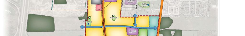
14 BARRHAVEN SOUTH URBAN EXPANSION STUDY AREA COMMUNITY DESIGN PLAN FINAL TRANSPORTATION MASTER STUDY Community Design Plan February 23, 2018 Figure 2 Proposed Concept Plan ers w:\active\ \planning\traffic\report\tms\final\sbscdp_tms_report_final_rv.docx 9
15 BARRHAVEN SOUTH URBAN EXPANSION STUDY AREA COMMUNITY DESIGN PLAN FINAL TRANSPORTATION MASTER STUDY Community Design Plan February 23, PREFERRED ALTERNATIVE Through the CDP process, several CDP alternatives were developed for the subject lands. Each alternative was evaluated from a multi-disciplinary approach that included the natural environment, social environment, transportation network, servicing, and infrastructure costs. The Community Design Plan document contains the detailed evaluation of each alternative along with the selection process. The Demonstration Plan in Figure 3 below illustrates the preferred alternative. ers w:\active\ \planning\traffic\report\tms\final\sbscdp_tms_report_final_rv.docx 10
16 BARRHAVEN SOUTH URBAN EXPANSION STUDY AREA COMMUNITY DESIGN PLAN FINAL TRANSPORTATION MASTER STUDY Community Design Plan February 23, 2018 Figure 3 CDP Demonstration Plan of Preferred Alternative ers w:\active\ \planning\traffic\report\tms\final\sbscdp_tms_report_final_rv.docx 11
17 BARRHAVEN SOUTH URBAN EXPANSION STUDY AREA COMMUNITY DESIGN PLAN FINAL TRANSPORTATION MASTER STUDY Existing Transportation Environment February 23, EXISTING TRANSPORTATION ENVIRONMENT 4.1 ROADS AND TRAFFIC CONTROL The roadways under consideration in the study area are referenced from the City of Ottawa s Transportation Master Plan 2013 and are described as follows: Existing Greenbank Road Existing Greenbank Road is designated as a two-lane arterial north of Barnsdale Road and a twolane collector south of Barnsdale Road. North of Kilbirnie Drive, Existing Greenbank Road has an urban cross-section with a posted speed of 60km/h and south of Kilbirnie Drive, it has a rural crosssection with a posted speed of 80 km/h. Cambrian Road Between Borrisokane Road and Seeley s Bay Street, Cambrian Road is a two-lane rural arterial road with a posted speed limit of 70km/h. East of Seeley s Bay Street, Cambrian Road transitions to a two-lane urban arterial road with sidewalks along both sides and a posted speed limit of 50km/h. The intersection with Borrisokane Road is stop-controlled along Cambrian Road. The intersection with Existing Greenbank Road features a single-lane roundabout. Borrisokane Road North of Cambrian Road Borrisokane Road is a two-lane rural arterial road and south of Cambrian Road it is a two-lane rural collector road. Borrisokane Road has a posted speed limit of 80km/h and gravel shoulders are provided along both sides. The intersection with Barnsdale Road is stopcontrolled along the Borrisokane Road approach. Barnsdale Road Barnsdale Road is a two-lane arterial with a rural cross-section and a posted speed limit of 80 km/h. The intersection with Existing Greenbank Road is an all-way stop-controlled intersection. The intersection at Prince of Wales Drive is stop-controlled along the Barnsdale Road approach. Bankfield Road Bankfield Road is a two-lane arterial with a rural cross-section and a posted speed limit of 80 km/h. The intersection with Prince of Wales Drive is signalized. ers w:\active\ \planning\traffic\report\tms\final\sbscdp_tms_report_final_rv.docx 12
18 BARRHAVEN SOUTH URBAN EXPANSION STUDY AREA COMMUNITY DESIGN PLAN FINAL TRANSPORTATION MASTER STUDY Existing Transportation Environment February 23, 2018 Prince of Wales Drive Prince of Wales Drive is a two-lane arterial with a rural cross-section and a posted speed limit of 80 km/h. The intersection with Existing Greenbank Road is stop-controlled along the Existing Greenbank Road approach. Viewbank Road Viewbank Road is a two-lane local road with a rural cross-section and a posted speed limit of 50 km/h. The intersection with Barnsdale Road is stop-controlled along the Viewbank Road approach. Figure 4 illustrates the existing intersection control and lane configuration for the study area intersections. ers w:\active\ \planning\traffic\report\tms\final\sbscdp_tms_report_final_rv.docx 13
19 Borrisokane Road Future Realigned Greenbank Road Existing Greenbank Road Cambrian Road Prince of Wales Drive Barnsdale Road Viewbank Road Bankfield Road Prince of Wales Drive Barrhaven South Urban Expansion Study Area CDP Transportation Master Study Figure Existing Intersection Control and Lane Configuration


20 BARRHAVEN SOUTH URBAN EXPANSION STUDY AREA COMMUNITY DESIGN PLAN FINAL TRANSPORTATION MASTER STUDY Existing Transportation Environment February 23, TRANSIT Transit service is provided to the Study Area via route 95. Route 95 is a regular bus route that runs from the Minto Centre Recreation Complex to Trim Road and operates on a 15-minute headway during the morning peak period northbound and during the afternoon peak period southbound. Figure 5 illustrates existing study area transit routes. The TRANS Committee s 2011 NCR Household Origin-Destination Survey indicates that approximately 27% of residents traveling from the South Nepean district during the AM Peak Hour use transit as their primary mode of transportation. Similarly, approximately 24% of residents traveling to the South Nepean district during the PM Peak Hour use transit. Roughly 4% of residents traveling within the South Nepean district use transit as their primary travel mode. As outlined in the City of Ottawa s 2013 Transportation Master Plan, Bus Rapid Transit (BRT) is scheduled to be implemented along Existing Greenbank Road north of the Jock River and along Realigned Greenbank Road south of the Jock River, however, this scheduled upgrade is not included in the City s 2031 Affordable Network, therefore it will occur beyond Figure 5 Existing Study Area Transit Service Urban Expansion Study Area (Source: OC Transpo, accessed January 2018) ers w:\active\ \planning\traffic\report\tms\final\sbscdp_tms_report_final_rv.docx 15


21 BARRHAVEN SOUTH URBAN EXPANSION STUDY AREA COMMUNITY DESIGN PLAN FINAL TRANSPORTATION MASTER STUDY Existing Transportation Environment February 23, PEDESTRIAN AND CYCLING NETWORKS Within the Barrhaven South community there are bicycle paths, paved shoulders, and sidewalks that connect the various neighbourhoods. There are numerous bicycle paths along the Jock River east of Existing Greenbank Road, within the Half Moon Bay North community, as well as along Existing Greenbank Road between Cambrian Road and Kilbirnie Drive and crossing the Jock River. Along Cambrian Road east of Existing Greenbank Road there is a bicycle lane that continues along Jockvale Road and Longfields Drive to Strandherd Drive. South of Cambrian Road, Jockvale Road has paved shoulders. Paved shoulders are also provided along Prince of Wales Drive. In terms of pedestrian facilities, there are various sidewalks along the vast majority of the streets within the Half Moon Bay and Stonebridge communities, including Cambrian Road and Existing Greenbank Road. In addition, there are multi-use pathways along the Jock River, east of Existing Greenbank Road. Figure 6 illustrates the existing pedestrian and cycling facilities within the study area. Figure 6 Existing Pedestrian and Cycling Network Urban Expansion Study Area (Source: geoottawa, accessed January 11 th, 2015) ers w:\active\ \planning\traffic\report\tms\final\sbscdp_tms_report_final_rv.docx 16
22 BARRHAVEN SOUTH URBAN EXPANSION STUDY AREA COMMUNITY DESIGN PLAN FINAL TRANSPORTATION MASTER STUDY Existing Transportation Environment February 23, EXISTING TRAFFIC VOLUMES Traffic counts were provided by the City of Ottawa at most study area intersections for the years 2013 and Where traffic counts were older than 2013, they were supplemented by counts undertaken by Stantec in July Using the TRANS regional transportation model data, growth rates were determined at three stations along the Jock River Screenline (Borrisokane Road, Existing Greenbank Road, and Jockvale Road). These growth rates were applied to the 2013 and 2014 traffic counts to bring them to 2016 volumes based on their location within the study area (i.e. traffic volumes traveling along Borrisokane Road were applied the growth percentage corresponding to the Borrisokane Road station growth at the Jock River Screenline). For turning movements that were not directly associated with a screenline station, a nominal 2% annual rate of growth was applied. Traffic volumes were then balanced between intersections starting from the north and heading south towards Bankfield Road. It should be noted that the City recently provided updated 2017 traffic volumes at the Barnsdale Road at Prince of Wales Drive intersection. As these volumes are the most up to date, they were used in the analysis of the existing conditions. Figure 7 and Figure 8 illustrate 2016 existing AM and PM peak hour traffic volumes at the study area intersections. Appendix B contains the traffic data and is provided for reference. ers w:\active\ \planning\traffic\report\tms\final\sbscdp_tms_report_final_rv.docx 17
23 AM Peak Hour Borrisokane Road Future Realigned Greenbank Road Existing Greenbank Road Cambrian Road River Mist Road Kilbirnie Drive East West Collector Prince of Wales Drive Barnsdale Road Viewbank Road Bankfield Road 4 Prince of Wales Drive Barrhaven South Urban Expansion Study Area CDP Transportation Master Study Figure Existing Traffic Volumes - AM Peak Hour
24 PM Peak Hour Borrisokane Road Future Realigned Greenbank Road Existing Greenbank Road Cambrian Road River Mist Road Kilbirnie Drive East West Collector Prince of Wales Drive Barnsdale Road Viewbank Road Bankfield Road 7 Prince of Wales Drive Barrhaven South Urban Expansion Study Area CDP Transportation Master Study Figure Existing Traffic Volumes - PM Peak Hour
25 BARRHAVEN SOUTH URBAN EXPANSION STUDY AREA COMMUNITY DESIGN PLAN FINAL TRANSPORTATION MASTER STUDY Travel Demand Forecasting February 23, TRAVEL DEMAND FORECASTING 5.1 FUTURE ROAD NETWORK IMPROVEMENTS Several significant transportation improvements have been identified in the City of Ottawa s 2013 Transportation Master Plan (TMP) in the vicinity of the CDP area and are summarized in Table 1 below. Table Transportation Master Plan Scheduled Upgrades PROJECT DESCRIPTION TMP PHASE Realigned Greenbank Road Strandherd Drive Widening Chapman Mills Drive Cambrian Road Widening Southwest Transitway From Jockvale Road to Cambrian Road New four lane road including the Jock River Bridge From Cambrian Road towards the south New four lane road Widen from two to four lanes between Fallowfield Road and Jockvale Road New four lane arterial road from Longfields Drive to Strandherd Drive, includes Bus Rapid Transit Widen from two to four lanes from Realigned Greenbank Road to Jockvale Road From Barrhaven Centre to Cambrian Road Median Bus Rapid Transit Phase 1 ( ) Network Concept (i.e. beyond 2031) Phase 2 ( ) Arterial Road: Phase 2 ( ) Bus Rapid Transit: Network Concept (i.e. beyond 2031) Network Concept (i.e. beyond 2031) Network Concept (i.e. beyond 2031) The TMP suggests that Realigned Greenbank Road, from Jockvale Road to Cambrian Road, will be constructed during Phase 1 ( ). However, based on recent discussions with City of Ottawa staff, it has been confirmed that this segment of Realigned Greenbank Road will not be constructed as part of Phase 1. Instead, the funding that was earmarked for Realigned Greenbank Road was reallocated towards the widening of Strandherd Drive based on recent safety concerns regarding the VIA Rail crossings in the Barrhaven area. The next TMP update will determine the future timing of Realigned Greenbank Road. 5.2 FUTURE BACKGROUND DEVELOPMENTS The Barrhaven South community has experienced substantial growth over the past few years and that growth is anticipated to continue well into the future. There are numerous developments scheduled to occur in the vicinity of the subject site, as outlined in Table 2 and as illustrated in Figure 9 below. ers w:\active\ \planning\traffic\report\tms\final\sbscdp_tms_report_final_rv.docx 20
26 BARRHAVEN SOUTH URBAN EXPANSION STUDY AREA COMMUNITY DESIGN PLAN FINAL TRANSPORTATION MASTER STUDY Travel Demand Forecasting February 23, 2018 Table 2 Background Developments DEVELOPMENT LOCATION DEVELOPMENT SIZE ASSUMED BUILD-OUT Mattamy s Half Moon Bay South Phase 4 Minto s Quinn s Pointe South of Half Moon Bay South Phase 3, between Realigned Greenbank and Existing Greenbank West of Existing Greenbank Road, South of Half Moon Bay South 265 Residential Units Residential Units 2018 Mattamy s Half Moon Bay North Draft Plan 2 Glenview s 3387 Borrisokane Road Mattamy s Half Moon Bay West North of Cambrian Road, west of Greenbank Road North of Half Moon Bay West, east of Borrisokane Road, south of the Jock River North of Cambrian Road between Borrisokane Road and Realigned Greenbank Road 470 Residential Units Residential Units ,000 Residential Units 2024 Citi Gate Highway 416 Employment Lands Between Highway 416 and Strandherd Drive, south of Fallowfield, north of the train tracks 350,000 ft 2 GFA 95 hectares of Business Park Interim Phase: 2019 Ultimate Phase: 2029 These background developments were explicitly accounted for and added to the roadway network as background traffic volumes. By 2025, the majority of the background developments will be built and occupied with the exception of the Ultimate Phase for the Citi Gate development, which will be built by the 2031 horizon. Figure 10 and Figure 11 illustrate the background traffic forecasts from the aforementioned developments that are anticipated to be built by Figure 12 and Figure 13 illustrate the background traffic forecasts from the aforementioned developments that are anticipated to be built by ers w:\active\ \planning\traffic\report\tms\final\sbscdp_tms_report_final_rv.docx 21


27 BARRHAVEN SOUTH URBAN EXPANSION STUDY AREA COMMUNITY DESIGN PLAN FINAL TRANSPORTATION MASTER STUDY Travel Demand Forecasting February 23, 2018 Figure 9 Background Developments Legend: - Glenview s 3387 Borrisokane Road - Citi Gate - Mattamy s Half Moon Bay North Draft Plan 2 - Mattamy s Half Moon Bay West - Mattamy s Half Moon Bay South - Minto s Quinn s Pointe ers w:\active\ \planning\traffic\report\tms\final\sbscdp_tms_report_final_rv.docx 22
28 2025 Background Devs AM Borrisokane Road Realigned Greenbank Road Existing Greenbank Road Cambrian Road River Mist Road Kilbirnie Drive East West Collector Prince of Wales Drive Barnsdale Road Viewbank Road Bankfield Road 27 Prince of Wales Drive Barrhaven South Urban Expansion Study Area CDP Transportation Master Study Figure Background Developments AM Peak Hour
29 2025 Background Devs PM Borrisokane Road Realigned Greenbank Road Existing Greenbank Road Cambrian Road River Mist Road Kilbirnie Drive East West Collector Prince of Wales Drive Barnsdale Road Viewbank Road Bankfield Road 47 Prince of Wales Drive Barrhaven South Urban Expansion Study Area CDP Transportation Master Study Figure Background Developments PM Peak Hour
30 2031 Background Devs AM Borrisokane Road Realigned Greenbank Road Existing Greenbank Road Cambrian Road River Mist Road Kilbirnie Drive East West Collector Prince of Wales Drive Barnsdale Road Viewbank Road Bankfield Road 45 Prince of Wales Drive Barrhaven South Urban Expansion Study Area CDP Transportation Master Study Figure Background Developments AM Peak Hour
31 2031 Background Devs PM Borrisokane Road Realigned Greenbank Road Existing Greenbank Road Cambrian Road River Mist Road Kilbirnie Drive East West Collector Prince of Wales Drive Barnsdale Road Viewbank Road Bankfield Road 47 Prince of Wales Drive Barrhaven South Urban Expansion Study Area CDP Transportation Master Study Figure Background Developments PM Peak Hour
32 BARRHAVEN SOUTH URBAN EXPANSION STUDY AREA COMMUNITY DESIGN PLAN FINAL TRANSPORTATION MASTER STUDY Travel Demand Forecasting February 23, SITE TRAFFIC GENERATION Land Use and Trip Generation Rates The Institute of Transportation Engineers (ITE) Trip Generation Manual (9 th Edition) was used to estimate traffic generated by the CDP development area. The ITE land use codes 210 Single Detached Houses, 220 Apartment, 230 Residential Condo / Townhouse, 520 Elementary School, and 826 Specialty Retail were thought to be most representative of the proposed land uses. Table 3 summarizes the trip rates obtained from the ITE Trip Generation Manual and the ensuing sections describe the methodology used to convert these trips to person trips across all modes. Table 3 ITE Trip Generation Rates ITE LAND USE 210 Single Detached Houses INDEPENDENT VARIABLE MORNING PEAK HOUR AFTERNOON PEAK HOUR In Out Total In Out Total Units Apartment Units Residential Condo / Townhouse Units Elementary School Gross Floor Area (1000 ft 2 ) Specialty Retail Gross Floor Area (1000 ft 2 ) Conversion of ITE Rates to Person Trips The notion of quantifying the volume of person trips expected to be generated by a given development is becoming a commonly accepted practice. It is aimed at quantifying the expected demands across the primary modes of transportation. In order to convert ITE rates to person trips, the rates obtained from the ITE Trip Generation Manual were adjusted to account for an inherent transit modal share and auto occupancy. An assumed transit share of 10% was thought to be inherent within the ITE rates and an auto occupancy rate of 1.1 persons per vehicle was also assumed to be inherent within the ITE rates. The proposed development is anticipated to generate approximately 1360 and 1510 person trips during the AM and PM peak hours, respectively. Table 4 outlines the conversion from auto trips to person trips. ers w:\active\ \planning\traffic\report\tms\final\sbscdp_tms_report_final_rv.docx 27
33 BARRHAVEN SOUTH URBAN EXPANSION STUDY AREA COMMUNITY DESIGN PLAN FINAL TRANSPORTATION MASTER STUDY Travel Demand Forecasting February 23, 2018 Table 4 Conversion to Person Trips ITE LAND USE 210 Single Detached Houses 220 Apartment 230 Residential Condo / Townhouse 520 Elementary School 826 Specialty Retail Total Development CONVERSION MORNING PEAK HOUR AFTERNOON PEAK HOUR In Out Total In Out Total Trip Gen Transit Share 10% Auto Occupancy Total Person Trips Trip Gen Transit Share 10% Auto Occupancy Total Person Trips Trip Gen Transit Share 10% Auto Occupancy Total Person Trips Trip Gen Transit Share 10% Auto Occupancy Total Person Trips Trip Gen Transit Share 10% Auto Occupancy Total Person Trips Trip Generation Transit Share 10% Auto Occupancy Total Person Trips Modal Share Adjustments In order to convert the person trips to auto trips, the person trips were assigned to the four primary modal shares (i.e. auto, passenger, transit, and active moves) for each specific land use. Based on limited existing transit service and active modes facilities in the immediate study area, it was assumed that the auto modal share will be 90% with the remaining 10% encompassing passenger, transit, and active modes. The 90% auto modal share assumption ensures a conservative approach to generating site traffic for the CDP area. In terms of vehicle trips, the CDP development area is anticipated to generate 1225 and 1355 auto trips (two-way) during the AM and PM peak hours, respectively. Table 5 summarizes the expected person trips by modal share. ers w:\active\ \planning\traffic\report\tms\final\sbscdp_tms_report_final_rv.docx 28
34 BARRHAVEN SOUTH URBAN EXPANSION STUDY AREA COMMUNITY DESIGN PLAN FINAL TRANSPORTATION MASTER STUDY Travel Demand Forecasting February 23, 2018 Table 5 Person Trips by Modal Share ITE LAND USE 210 Single Detached Houses 220 Apartment 230 Residential Condo / Townhouse 520 Elementary School 826 Specialty Retail Total Development MODAL SHARE MORNING PEAK HOUR AFTERNOON PEAK HOUR In Out Total In Out Total Auto 90% Passenger/Transit/Active Modes 10% Auto 90% Passenger/Transit/Active Modes 10% Auto 90% Passenger/Transit/Active Modes 10% Auto 90% Passenger/Transit/Active Modes 10% Auto 90% Passenger/Transit/Active Modes 10% Auto Passenger/ Transit / Active Modes Pass-By and Internal Capture Trips Pass-by trips are considered intermediate stops between an origin and a destination. They are site trips that are drawn from existing traffic volumes on the road network that are passing-by the site. While the total number of trips generated by a given development remains the same, the turning movements at intersections and site access require adjustments to reflect pass-by traffic. The rate of pass-by traffic is based on the specific land use and the rates were obtained from the ITE Trip Generation Manual. When predicting trips that are associated with complementary land uses the interaction of traffic between those land use types must be accounted for by applying the principals of internal capture adjustments. Internal capture trips are trips which are shared between two or more uses on the same site. A portion of the site trips for a given land use is often drawn from an adjacent land uses, or, what is considered to be the primary anchor of a site. Internal capture adjustments were made to account for vehicle trips that visit more than one land use within a specific site (i.e. the commercial site the CDP) or within a specific area of study (i.e. an elementary school within a predominantly residential area). Since these trips are contained within the subject site, accounting for each trip individually on the roadway network would result in double-counting. For this reason, land uses that may have associated internal capture trips between one another ultimately had their net new trips adjusted consistent with typical industry standards. Table 6 below outlines the pass-by and internal capture percentages that were used for each land use in the subject development. ers w:\active\ \planning\traffic\report\tms\final\sbscdp_tms_report_final_rv.docx 29
35 BARRHAVEN SOUTH URBAN EXPANSION STUDY AREA COMMUNITY DESIGN PLAN FINAL TRANSPORTATION MASTER STUDY Travel Demand Forecasting February 23, 2018 Table 6 Pass-By and Internal Capture Rates LAND USE PASS-BY INTERNAL CAPTURE AM Peak Hour PM Peak Hour AM Peak Hour PM Peak Hour 210 Single Detached Houses 0% 0% 0% 0% 220 Apartment 0% 0% 0% 0% 230 Residential Condo / Townhouse 0% 0% 0% 0% 520 Elementary School 0% 0% 70% 70% 826 Specialty Retail N/A 34% N/A 34% Table 7 summarizes the expected pass-by and internal capture trips by modal share. Table 7 Pass-By and Internal Capture ITE LAND USE 210 Single Detached Houses 220 Apartment 230 Residential Condo / Townhouse 520 Elementary School 826 Specialty Retail Total Development PASS-BY / INTERNAL CAPTURE MORNING PEAK HOUR AFTERNOON PEAK HOUR In Out Total In Out Total Auto Trips Pass-By Internal Capture Net New Auto Trips Auto Trips Pass-By Internal Capture Net New Auto Trips Auto Trips Pass-By Internal Capture Net New Auto Trips Auto Trips Pass-By Internal Capture Net New Auto Trips Auto Trips Pass-By Internal Capture Net New Auto Trips Auto Trips Pass-By Internal Capture Net New Auto Trips Following the application of the pass-by and internal capture rates, the development is expected to generate approximately 990 and 1235 net new auto trips (two-way) during the AM and PM peak hours, respectively. ers w:\active\ \planning\traffic\report\tms\final\sbscdp_tms_report_final_rv.docx 30
36 BARRHAVEN SOUTH URBAN EXPANSION STUDY AREA COMMUNITY DESIGN PLAN FINAL TRANSPORTATION MASTER STUDY Travel Demand Forecasting February 23, SITE TRIP DISTRIBUTION AND ASSIGNMENT The distribution of traffic to / from the study area was determined through examination of the TRANS Committee s 2011 Origin-Destination (O-D) Survey for the South Nepean District. Table 8 provides a summary of the estimated distribution for the traffic generated by the proposed development. Table 8 Traffic Distribution from the South Nepean District VIA (TO / FROM) CARDINAL DIRECTION % Distribution North 25% East 25% South 5% West 5% Internal within the South Nepean District 40% Total 100% The anticipated site traffic generated by the CDP development area was assigned to the boundary road network using a logical pattern of primary roads (i.e. along arterials and collectors). For the purposes of assigning site traffic to the boundary road network, Realigned Greenbank Road was assumed to not be in place prior to the ultimate 2031 horizon, which is consistent with the timelines outlined in the City s Transportation Master Plan. This enables the subject transportation assessment to determine if Realigned Greenbank Road or portions of Realigned Greenbank Road - will in fact be required in order to enable the development to proceed and / or whether other intersection improvements will be required to support it. The CDP lands to the east of Realigned Greenbank Road were assumed to be built and occupied by the interim 2025 future horizon while the remaining CDP lands west of Realigned Greenbank Road were assumed to be built and occupied by the ultimate 2031 horizon. Figure 14 and Figure 15 illustrate the 2025 interim site traffic volumes and Figure 16 and Figure 17 illustrate the 2031 ultimate site traffic volumes. ers w:\active\ \planning\traffic\report\tms\final\sbscdp_tms_report_final_rv.docx 31
37 2025 Site Trips AM Peak Borrisokane Road Realigned Greenbank Road Existing Greenbank Road Cambrian Road River Mist Road in 170 out Kilbirnie Drive East West Collector Prince of Wales Drive Barnsdale Road 10 Viewbank Road Bankfield Road 10 Prince of Wales Drive Barrhaven South Urban Expansion Study Area CDP Transportation Master Study Figure Interim Site Traffic Volumes AM Peak Hour
38 2025 Site Trips PM Peak Borrisokane Road Realigned Greenbank Road Existing Greenbank Road Cambrian Road River Mist Road in 402 out Kilbirnie Drive East West Collector Prince of Wales Drive Barnsdale Road 19 Viewbank Road Bankfield Road 19 Prince of Wales Drive Barrhaven South Urban Expansion Study Area CDP Transportation Master Study Figure Interim Site Traffic Volumes PM Peak Hour
39 2031 Site Trips - AM Peak Borrisokane Road Realigned Greenbank Road Existing Greenbank Road Cambrian Road River Mist Road 0 in out Kilbirnie Drive East West Collector Prince of Wales Drive Barnsdale Road 15 Viewbank Road Bankfield Road 15 Prince of Wales Drive Barrhaven South Urban Expansion Study Area CDP Transportation Master Study Figure Ultimate Site Traffic Volumes AM Peak Hour
40 2031 Site Trips - PM Peak Borrisokane Road Realigned Greenbank Road Existing Greenbank Road Cambrian Road River Mist Road 0 in out Kilbirnie Drive East West Collector Prince of Wales Drive Barnsdale Road 37 Viewbank Road Bankfield Road 37 Prince of Wales Drive Barrhaven South Urban Expansion Study Area CDP Transportation Master Study Figure Ultimate Site Traffic Volumes PM Peak Hour
41 BARRHAVEN SOUTH URBAN EXPANSION STUDY AREA COMMUNITY DESIGN PLAN FINAL TRANSPORTATION MASTER STUDY Transportation Impact Assessment February 23, TRANSPORTATION IMPACT ASSESSMENT 6.1 JOCK RIVER SCREENLINE GROWTH A screenline is an imaginary line that is drawn along the boundary of an area of interest, in this case, the Jock River. System capacity across a screenline is determined by the number of roads and travel lanes which cross the screenline. Traffic demands are then compared to the available capacity to determine if there is a shortfall in system capacity. Screenline data from the TRANS regional transportation model for the Jock River screenline (screenline 49) was obtained from the City of Ottawa s Transportation Modeling department for the years 2011 and The TRANS model and screenline data reflects the planned transportation network identified in the City of Ottawa s 2013 TMP (i.e. the affordable transportation plan). As outlined previously, the affordable transit network in the TMP does not include the Bus Rapid Transit component of Realigned Greenbank Road as occurring prior to As such, implicit within the screenline data is the fact that Realigned Greenbank Road will not include Bus Rapid Transit prior to 2031 which is reflected in Table 9 below. Annual growth rates were calculated for the entire screenline and at each station between Borrisokane Road and Prince of Wales Drive between 2011 and 2031 (assuming a straight-line growth assumption), which is outlined in Table 9 below. The inbound movements represent vehicles traveling towards the urban core (i.e. leaving Barrhaven South by traveling north across the screenline) and outbound movements represent vehicles traveling away from the urban core (i.e. entering Barrhaven South by travelling south across the screenline). The inbound movement represents the predominant direction of travel during the AM peak and the outbound movement represents the predominant direction of travel during the PM peak. As there are updated 2015 counts at the Borrisokane Road screenline station, these volumes replaced the 2011 volumes and were used in calculating the annual growth rate to Total annual growth across the entire screenline is forecasted to be 7% during the AM peak (predominant direction being inbound ) and 6% during the PM peak (predominant direction being outbound ). At individual stations the majority of the screenline growth is anticipated to occur at the Borrisokane Road and Existing Greenbank Road locations. ers w:\active\ \planning\traffic\report\tms\final\sbscdp_tms_report_final_rv.docx 36
42 BARRHAVEN SOUTH URBAN EXPANSION STUDY AREA COMMUNITY DESIGN PLAN FINAL TRANSPORTATION MASTER STUDY Transportation Impact Assessment February 23, 2018 Table 9 Jock River Screenline Growth from 2011 to 2031 STATION Borrisokane Greenbank DIRECTION 2011 VOLUMES 2031 VOLUMES AM Peak Hour PM Peak Hour AM Peak Hour PM Peak Hour ANNUAL GROWTH 2011 TO 2031 AM Peak PM Peak Hour Hour Inbound % 0% Outbound % 8% Inbound % 6% Outbound % 11% Jockvale Inbound % 1% Outbound % 6% Prince of Wales Total Inbound % 5% Outbound % 5% Inbound % 3% Outbound % 6% Notes: 1. Taken from 2015 turning movement counts at Borrisokane / Cambrian EXISTING CONDITIONS Jock River Screenline Performance Using the annual growth rates from Table 9, the screenline data from 2011 (or 2015 for Borrisokane) was interpolated to the existing 2016 condition and can be seen in Table 10 below. Table Jock River Screenline Analysis STATION Borrisokane DIRECTION AM Peak Hour PM Peak Hour 2016 EXISTING CONDITIONS Lanes Capacity (Veh/hr) AM Peak v/c 1 PM Peak v/c 1 Inbound Outbound Greenbank Inbound Outbound Jockvale Inbound Outbound Prince of Wales Total Inbound Outbound Inbound Outbound Notes: 1. Volume to capacity ratio: compares roadway demand (vehicle volumes) with roadway supply (roadway carrying capacity). As shown in Table 10, the volumes fall well below the capacities at all four stations along the Jock River screenline under 2016 existing conditions. In addition, the total volume across the entire ers w:\active\ \planning\traffic\report\tms\final\sbscdp_tms_report_final_rv.docx 37
43 BARRHAVEN SOUTH URBAN EXPANSION STUDY AREA COMMUNITY DESIGN PLAN FINAL TRANSPORTATION MASTER STUDY Transportation Impact Assessment February 23, 2018 screenline is less than half of the existing available capacity which suggests that significant residual capacity exists across the screenline to accommodate future growth. During the AM peak, where predominant direction is inbound, the screenline currently operates at v/c During the PM peak, where the predominant direction is outbound, the screenline currently operates at v/c Intersection Performance An assessment of the study area intersections was undertaken to determine the operational characteristics of these intersections under existing 2016 conditions. The operational analysis was facilitated by Synchro 9.0 software package for stop-controlled and signalized intersections and SIDRA 6.1 for roundabout intersections. Signal timings were obtained from the City of Ottawa and were used in the assessment of 2016 existing conditions. Table 11 provides a summary of 2016 existing intersection operations. Barnsdale Road at Prince of Wales Drive Barnsdale Road at Prince of Wales Drive intersection currently operates at a level of service (LOS) F based on the excessive delay experienced by the eastbound and westbound approaches. The City of Ottawa is currently undertaking a functional design study of this intersection where it will be determined whether traffic signals or a roundabout will be required to address the operational constraints at this location. As such, recommendations to improve this intersection will not be made as part of the subject TMS study. Bankfield Road at Prince of Wales Drive The Bankfield Road at Prince of Wales Drive intersection currently operates at capacity during both the AM and PM peak hours. As outlined in the Realigned Greenbank Road and South West Transitway Extension Environmental Assessment Study (MMM 2014), this intersection is planned to be upgraded to a double lane roundabout. Intersection performance analysis, however, indicates that a single lane roundabout would be sufficient to address the existing intersection performance issues currently experienced at this intersection. Figure 18 illustrates the required intersection control and lane configuration to accommodate the 2016 existing conditions. Appendix C contains detailed intersection performance worksheets. ers w:\active\ \planning\traffic\report\tms\final\sbscdp_tms_report_final_rv.docx 38
44 BARRHAVEN SOUTH URBAN EXPANSION STUDY AREA COMMUNITY DESIGN PLAN FINAL TRANSPORTATION MASTER STUDY Transportation Impact Assessment February 23, 2018 Table Existing Intersection Operations INTERSECTION TRAFFIC CONTROL APPROACH / MOVEMENT LOS V/C 2 DELAY (s) Q 3 (m) Cambrian Road at Borrisokane Road Existing Greenbank Road at Cambrian Road Barnsdale Road at Borrisokane Road Barnsdale Road at Viewbank Road Barnsdale Road at Existing Greenbank Road Barnsdale Road at Prince of Wales Drive Existing Greenbank Road at Prince of Wales Drive Bankfield Road at Prince of Wales Drive Minor Stop Control Single Lane Roundabout Minor Stop Control Minor Stop Control All-Way Stop Control Minor Stop Control Minor Stop Control Traffic Signals Single Lane Roundabout WB Left / Right B (A) 0.38 (0.16) 10.6 (9.6) 13.5 (4.2) NB Through / Right A (A) 0.02 (0.03) 0.0 (0.0) 0.0 (0.0) SB Left / Through A (A) 0.06 (0.17) 5.7 (6.7) 1.5 (6.7) Overall Intersection A (A) (6.9) - EB Left / Through / Right A (A) 0.23 (0.35) 1.8 (3.4) 9.2 (16.4) WB Left / Through / Right A (A) 0.19 (0.32) 2.3 (2.3) 7.9 (14.4) NB Left / Through / Right A(A) 0.33 (0.24) 2.1 (2.1) 14.7 (10.4) SB Left / Through / Right A (A) 0.18 (0.45) 1.6 (2.4) 7.3 (22.7) Overall Intersection A (A) 0.33 (0.45) 2.1 (22.7) - EB Left / Through A (A) 0.02 (0.02) 1.2 (1.3) 0.3 (0.4) WB Through / Right A (A) 0.08 (0.12) 0.0 (0.0) 0.0 (0.0) SB Left / Right A (B) 0.04 (0.08) 9.6 (10.1) 1.1 (2.0) Overall Intersection A (A) (2.0) - EB Left / Through A (A) 0.08 (0.09) 0.0 (0.0) 0.0 (0.0) WB Through / Right A (A) 0.00 (0.00) 0.1 (0.0) 0.0 (0.0) NB Left / Right A (B) 0.01 (0.01) 9.7 (10.2) 0.1 (0.1) Overall Intersection A (A) (0.1) - EB Left / Through / Right A (B) 0.19 (0.35) 9.2 (11.0) 0.7 (1.6) WB Left / Through / Right A (B) 0.19 (0.23) 9.3 (10.1) 0.7 (0.8) NB Left / Through / Right B (B) 0.32 (0.46) 10.2 (12.7) 1.3 (2.4) SB Left / Through / Right A (B) 0.23 (0.22) 9.6 (10.2) 0.9 (0.8) Overall Intersection A (B) (11.3) - EB Left / Through / Right F (F) 1.34 (1.07) (147.1) (66.7) WB Left / Through / Right C (E) 0.25 (0.35) (35.0) 7.2 (11.2) NB Left / Through / Right A (A) 0.01 (0.01) 0.2 (0.2) 0.1 (0.1) SB Left / Through / Right A (A) 0.01 (0.00) 0.2 (0.1) 0.2 (0.1) Overall Intersection E (C) (19.1) - EB Left / Right B (C) 0.33 (0.52) 12.9 (22.7) 11.0 (21.8) NB Left A (B) 0.10 (0.27) 8.0 (10.6) 2.5 (8.2) Through A (A) 0.37 (0.20) 0.0 (0.0) 0.0 (0.0) SB Through / Right A (A) 0.14 (0.43) 0.0 (0.0) 0.0 (0.0) Overall Intersection A (A) (4.8) - EB Left / Through / Right F (F) 1.22 (1.10) (98.4) #252.6 (#268.6) WB Left / Through / Right B (A) 0.61 (0.53) 24.5 (21.5) (113.3) NB SB Left / Through C (D) 0.76 (0.81) 50.3 (61.8) #128.3 (#95.6) Right A (A) 0.02 (0.01) 34.8 (37.2) 0.0 (0.0) Left A (A) 0.34 (0.39) 28.1 (27.5) 26.3 (41.2) Through / Right A (F) 0.46 (1.12) 29.1 (111.5) 80.8 (#292.8) Overall Intersection F (F) 1.08 (1.25) 66.3 (78.1) - Improvement: Upgrade Traffic Control to Roundabout EB Left / Through / Right A (B) 0.44 (0.76) 2.7 (11.4) 24.1 (72.7) WB Left / Through / Right A (A) 0.62 (0.46) 7.5 (3.1) 43.9 (23.1) NB Left / Through / Right A (A) 0.47 (0.34) 4.9 (5.0) 25.0 (17.0) SB Left / Through / Right A (A) 0.43 (0.82) 3.4 (8.4) 22.6 (96.8) Overall Intersection A (A) 0.62 (0.82) 4.7 (7.8) - Notes: 1. Table format: AM (PM) 2. v/c represents the anticipated volume divided by the predicted capacity th Percentile Queue (m) 4. # - 95 th percentile volume exceeds capacity, queue may be longer ers w:\active\ \planning\traffic\report\tms\final\sbscdp_tms_report_final_rv.docx 39
45 Borrisokane Road Future Realigned Greenbank Road Existing Greenbank Road Cambrian Road Prince of Wales Drive Barnsdale Road Viewbank Road Currently under review by City Bankfield Road Single lane roundabout Prince of Wales Drive Barrhaven South Urban Expansion Study Area CDP Transportation Master Study Figure 18 Intersection Control and Lane Configuration Required to Accommodate 2016 Existing Traffic Volumes
46 BARRHAVEN SOUTH URBAN EXPANSION STUDY AREA COMMUNITY DESIGN PLAN FINAL TRANSPORTATION MASTER STUDY Transportation Impact Assessment February 23, FUTURE BACKGROUND CONDITIONS Future background conditions for the 2025 horizon were assessed to determine transportation improvements that may be required to address growth in traffic exclusive from improvements that may be required to accommodate traffic generated by the subject lands. Figure 19 and Figure 20 illustrate the 2025 future background traffic volumes. The improvements required to address the 2016 existing conditions were carried forward in the analysis of 2025 future background conditions. Table 12 summarizes the operational characteristics of the study area intersections under 2025 future background conditions. Existing Greenbank Road at Cambrian Road The Existing Greenbank Road at Cambrian Road intersection is projected to experience significant delays in the southbound direction during the PM peak hour under 2025 future background conditions. As outlined in the Cambrian Road Widening Environmental Assessment Study (Stantec 2014), the Existing Greenbank Road and Cambrian Road intersection is recommended to be upgraded to a double-lane roundabout. The Cambrian Road EA assumed that Realigned Greenbank Road would be constructed as per the timelines set forth in the TMP, however, and the EA concluded that the north leg of the Existing Greenbank Road at Cambrian Road intersection could be maintained as a two-lane cross-section with one southbound lane entering the roundabout and one northbound lane exiting the intersection. Through this CDP process, it was found that the timing of Realigned Greenbank Road will not follow the City s TMP and will be determined at the next TMP update. As part of the subject study, it was assumed that Realigned Greenbank Road will not be in place, and therefore, Existing Greenbank Road will be heavily relied on as a major route to / from the Barrhaven South community. As such, the volumes along Existing Greenbank Road will be significantly higher than the volumes projected in the Cambrian Road EA. To accommodate the projected southbound volumes along Existing Greenbank Road, a southbound right turn lane is required at the Existing Greenbank Road at Cambrian Road roundabout intersection. Barnsdale Road at Prince of Wales Drive Consistent with the analysis of 2016 existing conditions, the Barnsdale Road at Prince of Wales Drive intersection is projected to operate with significant delays. The City of Ottawa is currently undertaking a functional design study of this intersection and as part of this study, it will be determined whether traffic signals or a roundabout will be required to address the operational ers w:\active\ \planning\traffic\report\tms\final\sbscdp_tms_report_final_rv.docx 41
47 BARRHAVEN SOUTH URBAN EXPANSION STUDY AREA COMMUNITY DESIGN PLAN FINAL TRANSPORTATION MASTER STUDY Transportation Impact Assessment February 23, 2018 constraints at this location. As such, recommendations to improve this intersection will not be made as part of the subject study. Existing Greenbank Road at Prince of Wales Drive By 2025 the eastbound movement at the Existing Greenbank Road at Prince of Wales Drive intersection is projected to operate with significant delays during the PM peak hour. As outlined in the Realigned Greenbank Road and South West Transitway Extension Environmental Assessment Study (MMM 2014), this intersection is ultimately planned to be upgraded to include traffic signals, left and right turn auxiliary lanes, and dual northbound and southbound through lanes along Prince of Wales Drive. To address the projected delays at this intersection under 2025 future background conditions, however, only traffic signals are required with left turn auxiliary lanes. Bankfield Road at Prince of Wales Drive The single lane roundabout configuration which was recommended to accommodate existing conditions - is insufficient to handle the projected 2025 future background traffic volumes. As outlined in the Realigned Greenbank Road and South West Transitway Extension Environmental Assessment Study (MMM 2014), this intersection is ultimately planned to be upgraded to a double lane roundabout. Incorporating aspects of the ultimate EA design, it was found that this intersection requires a southbound right turn lane and dual eastbound through lanes to operate acceptably with the projected 2025 future background traffic volumes. Figure 21 illustrates the 2025 future background intersection control and lane configuration. Appendix C contains detailed intersection performance worksheets. ers w:\active\ \planning\traffic\report\tms\final\sbscdp_tms_report_final_rv.docx 42
48 2025 Future Background AM Borrisokane Road Realigned Greenbank Road Existing Greenbank Road Cambrian Road River Mist Road Kilbirnie Drive East West Collector Prince of Wales Drive Barnsdale Road Viewbank Road Bankfield Road 5 Prince of Wales Drive Barrhaven South Urban Expansion Study Area CDP Transportation Master Study Figure Future Background Traffic Volumes AM Peak Hour
49 2025 Future Background PM Borrisokane Road Realigned Greenbank Road Existing Greenbank Road Cambrian Road River Mist Road Kilbirnie Drive East West Collector Prince of Wales Drive Barnsdale Road Viewbank Road Bankfield Road 9 Prince of Wales Drive Barrhaven South Urban Expansion Study Area CDP Transportation Master Study Figure Future Background Traffic Volumes PM Peak Hour
50 BARRHAVEN SOUTH URBAN EXPANSION STUDY AREA COMMUNITY DESIGN PLAN FINAL TRANSPORTATION MASTER STUDY Transportation Impact Assessment February 23, 2018 Table Future Background Intersection Operations INTERSECTION TRAFFIC CONTROL APPROACH / MOVEMENT LOS V/C 2 DELAY (s) Q 3 (m) Cambrian Road at Borrisokane Road Existing Greenbank Road at Cambrian Road Barnsdale Road at Borrisokane Road Barnsdale Road at Viewbank Road Barnsdale Road at Existing Greenbank Road Barnsdale Road at Prince of Wales Drive Existing Greenbank Road at Prince of Wales Drive Bankfield Road at Prince of Wales Drive Minor Stop Control Single Lane Roundabout Minor Stop Control Minor Stop Control All-Way Stop Control Minor Stop Control Minor Stop Control Traffic Signals Single Lane Roundabout Partial Double Lane Roundabout WB Left / Right C (C) 0.69 (0.53) 17.0 (15.3) 48.7 (25.1) NB Through / Right A (A) 0.03 (0.06) 0.0 (0.0) 0.0 (0.0) SB Left / Through A (A) 0.18 (0.38) 6.7 (8.3) 4.8 (14.0) Overall Intersection B (A) (9.9) - EB Left / Through / Right A (C) 0.61 (0.87) 3.7 (19.3) 41.2 (120.8) WB Left / Through / Right A (B) 0.45 (0.79) 5.4 (11.5) 25.0 (84.3) NB Left / Through / Right B (A) 0.82 (0.55) 17.9 (5.8) 93.9 (34.7) SB Left / Through / Right A (F) 0.36 (1.13) 3.0 (256.2) 41.2 (985.3) Overall Intersection A (F) 0.82 (1.13) 8.2 (88.6) - Improvement: Implementation of a Southbound Right Turn Lane EB Left / Through / Right A (C) 0.61 (0.93) 3.7 (32.4) 40.2 (171.6) WB Left / Through / Right A (B) 0.45 (0.79) 5.4 (11.5) 25.0 (84.5) NB Left / Through / Right B (A) 0.82 (0.55) 17.8 (6.0) 93.2 (35.2) SB Left / Through A (A) 0.22 (0.59) 2.5 (6.1) 10.0 (44.0) Right A (A) 0.11 (0.40) 2.6 (5.0) 4.1 (20.7) Overall Intersection A (B) 0.82 (0.93) 8.1 (14.2) - EB Left / Through A (A) 0.02 (0.03) 1.7 (1.9) 0.5 (0.7) WB Through / Right A (A) 0.09 (0.14) 0.0 (0.0) 0.0 (0.0) SB Left / Right B (B) 0.10 (0.13) 10.2 (10.8) 2.5 (3.5) Overall Intersection A (A) (2.7) - EB Left / Through A (A) 0.10 (0.10) 0.0 (0.0) 0.0 (0.0) WB Through / Right A (A) 0.00 (0.00) 0.1 (0.0) 0.0 (0.0) NB Left / Right B (B) 0.01 (0.01) 10.0 (10.6) 0.1 (0.1) Overall Intersection A (A) (0.1) - EB Left / Through / Right B (B) 0.26 (0.32) 10.6 (13.2) 1.0 (1.4) WB Left / Through / Right B (C) 0.39 (0.62) 12.1 (20.0) 1.9 (4.7) NB Left / Through / Right B (C) 0.30 (0.65) 10.9 (20.7) 1.3 (5.4) SB Left / Through / Right B (C) 0.41 (0.48) 12.2 (15.6) 2.1 (2.7) Overall Intersection B (C) (18.2) - EB Left / Through / Right F (F) 1.72 (1.48) (970.5) (294.0) WB Left / Through / Right D (E) 0.30 (0.45) 28.8 (47.3) 9.8 (17.9) NB Left / Through / Right A (A) 0.01 (0.01) 0.2 (0.2) 0.2 (0.2) SB Left / Through / Right A (A) 0.01 (0.00) 0.2 (0.1) 0.2 (0.1) Overall Intersection F (F) (119.5) - EB Left / Right C (F) 0.52 (0.94) 16.5 (101.5) 24.6 (136.2) NB Left A (B) 0.15 (0.45) 1.8 (12.9) 3.9 (18.7) Through A (A) 0.41 (0.21) 0.0 (0.0) 0.0 (0.0) SB Through / Right A (A) 0.15 (0.47) 0.0 (0.0) 0.0 (0.0) EB NB Overall Intersection A (C) (21.2) - Improvement: Upgrade Traffic Control to Signals with Left Turn Auxiliary Lanes Left A (A) 0.09 (0.02) 34.4 (37.4) 8.8 (3.2) Right A (A) 0.21 (0.21) 35.2 (38.8) 34.3 (37.6) Left A (C) 0.22 (0.77) 3.5 (29.0) 20.8 (#109.5) Through A (A) 0.48 (0.25) 5.0 (3.2) 87.6 (36.5) SB Through / Right A(D) 0.18 (0.82) 3.1 (27.2) 23.9 (#256.7) Overall Intersection A (C) 0.45 (0.75) 11.5 (25.1) - EB Left / Through / Right A (F) 0.59 (1.06) 3.9 (150.6) 39.3 (604.3) WB Left / Through / Right C (A) 0.89 (0.65) 30.3 (7.9) (48.9) NB Left / Through / Right B (B) 0.71 (0.57) 13.2 (11.0) 60.7 (38.2) SB Left / Through / Right A (F) 0.67 (0.1.15) 7.1 (290.3) 53.8 (1487.7) Overall Intersection B (F) 0.89 (1.15) 13.6 (1487.7) - Improvement: Implementation of an Exclusive Southbound Right Turn Lane and Dual Eastbound Through Lanes EB Left / Through / Right A (A) 0.28 (0.50) 2.8 (7.1) 13.1 (33.0) WB Left / Through / Right C (A) 0.87 (0.66) 25.3 (8.4) (50.3) NB Left / Through / Right B (B) 0.64 (0.56) 10.7 (12.5) 48.0 (36.9) SB Left / Through A (A) 0.31 (0.60) 4.0 (3.8) 15.4 (43.0) Right A (A) ) 2.6 (3.3) 14.9 (25.1) Overall Intersection B (A) 0.87 (0.66) 10.5 (6.5) - Notes: 1. Table format: AM (PM) 2. v/c represents the anticipated volume divided by the predicted capacity th Percentile Queue (m) 4. # - 95 th percentile volume exceeds capacity, queue may be longer ers w:\active\ \planning\traffic\report\tms\final\sbscdp_tms_report_final_rv.docx 45
51 Borrisokane Road Future Realigned Greenbank Road Existing Greenbank Road Cambrian Road Prince of Wales Drive Barnsdale Road Viewbank Road Currently under review by City Bankfield Road Partial double lane roundabout Prince of Wales Drive Barrhaven South Urban Expansion Study Area CDP Transportation Master Study Figure Future Background Intersection Control and Lane Configuration
52 BARRHAVEN SOUTH URBAN EXPANSION STUDY AREA COMMUNITY DESIGN PLAN FINAL TRANSPORTATION MASTER STUDY Transportation Impact Assessment February 23, TOTAL FUTURE CONDITIONS By 2025, the CDP lands to the east of Realigned Greenbank Road are assumed to be built and occupied Jock River Screenline Performance Using the annual growth rates from Table 9, the screenline data was interpolated to the 2025 total future horizon and can be seen in Table 13 below. Table Total Future Jock River Screenline Assessment STATION Borrisokane Greenbank Jockvale Prince of Wales Total DIRECTION AM Peak Hour PM Peak Hour Lanes 2025 TOTAL FUTURE Capacity (Veh / hr) AM Peak v/c PM Peak v/c Inbound Outbound Inbound Outbound Inbound Outbound Inbound Outbound Inbound Outbound As shown in Table 13, the volumes fall well below the capacities at all stations with the exception of the Greenbank Road station. Despite this, the total volume across the entire screenline is significantly less than the available capacity which suggests that there is residual capacity along the screenline as a whole. As drivers start to experience delays at the Greenbank Road station, they will likely alter their driving patterns and find alternate north-south routes to mitigate these delays. As the remaining screenline stations are projected to have residual capacity, commuters will have viable alternatives to cross the Jock River at Borrisokane, Jockvale, or Prince of Wales Drive. During the AM peak hour, where the predominant direction is inbound, the 2025 screenline is projected to operate at v/c During the PM peak hour, where the predominant direction is outbound, the screenline is projected to operate at v/c ers w:\active\ \planning\traffic\report\tms\final\sbscdp_tms_report_final_rv.docx 47
53 BARRHAVEN SOUTH URBAN EXPANSION STUDY AREA COMMUNITY DESIGN PLAN FINAL TRANSPORTATION MASTER STUDY Transportation Impact Assessment February 23, Intersection Performance The improvements required to address the 2025 future background conditions were carried forward in the analysis of 2025 total future conditions. Figure 22 and Figure 23 illustrate the 2025 total future traffic volumes. Table 14 below outlines the operations characteristics of the study area intersections under 2025 total future conditions. Existing Greenbank Road at Cambrian Road The Existing Greenbank Road at Cambrian Road intersection is projected to experience significant delays in the northbound direction during the AM peak hour and in the eastbound direction during the PM peak hour under 2025 total future conditions. As outlined in the Cambrian Road Widening Environmental Assessment Study (Stantec 2014), the Existing Greenbank Road and Cambrian Road intersection is recommended to be upgraded to a double-lane roundabout. To accommodate the projected 2025 total future traffic volumes at this intersection location, northbound and eastbound right turn lanes are required. Existing Greenbank Road at Barnsdale Road The Existing Greenbank Road at Barnsdale Road intersection is projected to operate with significant delays during the PM peak hour under 2025 total future conditions. As outlined in the Realigned Greenbank Road and South West Transitway Extension Environmental Assessment Study (MMM 2014), this intersection is planned to be upgraded to include traffic signals with left and right turn auxiliary lanes in most directions. In order to address the operational constraints at this intersection, traffic signals are required with left turn auxiliary lanes in all directions to accommodate the projected 2025 total future traffic volumes. Barnsdale Road at Prince of Wales Drive The City of Ottawa is currently undertaking a functional design study of the Prince of Wales Drive at Barnsdale Road intersection. As part of this functional design study, it will be determined whether traffic signals or a roundabout will be required to address the capacity and safety issues that currently exist at this intersection. As such, recommendations to improve this intersection will not be made as part of the subject study. Figure 24 illustrates the 2025 total future intersection control and lane configuration. Appendix C contains detailed intersection performance worksheets. ers w:\active\ \planning\traffic\report\tms\final\sbscdp_tms_report_final_rv.docx 48
54 2025 Total AM Borrisokane Road Realigned Greenbank Road Existing Greenbank Road Cambrian Road River Mist Road Kilbirnie Drive East West Collector Prince of Wales Drive Barnsdale Road Viewbank Road Bankfield Road 5 Prince of Wales Drive Barrhaven South Urban Expansion Study Area CDP Transportation Master Study Figure Total Future Traffic Volumes AM Peak Hour
55 2025 Total PM Borrisokane Road Realigned Greenbank Road Existing Greenbank Road Cambrian Road River Mist Road Kilbirnie Drive East West Collector Prince of Wales Drive Barnsdale Road Viewbank Road Bankfield Road 9 Prince of Wales Drive Barrhaven South Urban Expansion Study Area CDP Transportation Master Study Figure Total Future Traffic Volumes PM Peak Hour
56 BARRHAVEN SOUTH URBAN EXPANSION STUDY AREA COMMUNITY DESIGN PLAN FINAL TRANSPORTATION MASTER STUDY Transportation Impact Assessment February 23, 2018 Table Total Future Intersection Operations INTERSECTION TRAFFIC CONTROL APPROACH / MOVEMENT LOS V/C 2 DELAY (s) Q 3 (m) Cambrian Road at Borrisokane Road Existing Greenbank Road at Cambrian Road Barnsdale Road at Borrisokane Road Barnsdale Road at Viewbank Road Barnsdale Road at Existing Greenbank Road Barnsdale Road at Prince of Wales Drive Existing Greenbank Road at Prince of Wales Drive Bankfield Road at Prince of Wales Drive Existing Greenbank Road at East West Collector Minor Stop Control Single Lane Roundabout Minor Stop Control Minor Stop Control All-Way Stop Control Traffic Signals Minor Stop Control Traffic Signals Partial Double Lane Roundabout Minor Stop Control Notes: 1. Table format: AM (PM) 2. v/c represents the anticipated volume divided by the predicted capacity th Percentile Queue (m) 4. # - 95 th percentile volume exceeds capacity, queue may be longer WB Left / Right C (C) 0.81 (0.66) 24.1 (20.3) 48.7 (42.4) NB Through / Right A (A) 0.03 (0.06) 0.0 (0.0) 0.0 (0.0) SB Left / Through A (A) 0.21 (0.45) 7.0 (8.9) 4.8 (18.7) Overall Intersection C (A) (12.2) - EB Left / Through / Right A (F) 0.71 (1.16) 5.6 (306.9) 60.8 (1078.5) WB Left / Through / Right A (C) 0.53 (0.89) 8.1 (21.3) 32.9 (135.1) NB Left / Through / Right F (A) 1.11 (0.61) (6.8) (43.7) SB EB Left / Through A (A) 0.24 (0.68) 2.7 (9.2) 11.3 (61.6) Right A (A) 0.13 (0.51) 2.9 (7.4) 5.4 (30.9) Overall Intersection E (F) 1.11 (1.16) 79.0 (90.7) - Improvement: Implementation of Eastbound and Northbound Right Turn Lanes Left / Through A (A) 0.53 (0.60) 2.8 (7.8) 30.7 (46.0) Right A (A) 0.11 (0.41) 2.6 (5.9) 3.9 (22.0) WB Left / Through / Right B (C) 0.57 (0.90) 10.0 (24.2) 38.2 (146.1) NB SB Left / Through B (A) 0.67 (0.43) 10.2 (4.1) 58.4 (25.0) Right A (A) 0.25 (0.14) 6.4 (4.6) 11.0 (6.0) Left / Through A (A) 0.24 (0.68) 2.8 (9.2) 11.5 (61.6) Right A (A) 0.14 (0.51) 3.0 (7.4) 5.5 (30.9) Overall Intersection A (B) 0.67 (0.90) 8.3 (11.2) - EB Left / Through A (A) 0.02 (0.03) 1.7 (1.9) 0.5 (0.7) WB Through / Right A (A) 0.09 (0.14) 0.0 (0.0) 0.0 (0.0) SB Left / Right B (B) 0.10 (0.13) 10.2 (10.8) 2.5 (3.5) Overall Intersection A (A) (2.7) - EB Left / Through A (A) 0.10 (0.10) 0.0 (0.0) 0.0 (0.0) WB Through / Right A (A) 0.00 (0.00) 0.1 (0.0) 0.0 (0.0) NB Left / Right B (B) 0.01 (0.01) 10.0 (10.6) 0.1 (0.1) Overall Intersection A (A) (0.1) - EB Left / Through / Right B (C) 0.31 (0.42) 12.6 (18.1) 1.3 (2.1) WB Left / Through / Right C (F) 0.54 (1.00) 16.5 (133.0) 3.4 (27.9) NB Left / Through / Right B (F) 0.36 (0.85) 13.0 (51.5) 1.7 (13.1) SB Left / Through / Right D (E) 0.74 (0.79) 25.9 (39.3) 7.9 (9.4) EB WB NB SB Overall Intersection C (F) (72.7) - Improvement: Upgrade to Traffic Signals with exclusive left turn lanes (all directions) Left A (A) 0.08 (0.06) 24.0 (19.9) 6.4 (4.4) Through / Right A (A) 0.46 (0.33) 26.5 (21.7) 35.5 (34.1) Left A (A) 0.49 (0.39) 27.4 (22.4) 28.2 (29.8) Through / Right A (C) 0.56 (0.73) 28.4 (29.9) 42.8 (74.4) Left A (A) 0.01 (0.05) 4.1 (6.7) 1.9 (7.2) Through / Right A (A) 0.16 (0.35) 4.8 (8.8) 20.4 (57.0) Left A (A) 0.23 (0.23) 5.4 (8.2) 22.0 (23.7) Through / Right A (A) 0.22 (0.23) 5.2 (7.7) 29.0 (34.7) Overall Intersection A (A) 0.30 (0.46) 14.5 (16.7) - EB Left / Through / Right F (F) 2.80 (2.71) (3174.8) (689.0) WB Left / Through / Right D (F) 0.33 (0.55) 31.3 (66.6) 10.8 (25.0) NB Left / Through / Right A (A) 0.01 (0.01) 0.2 (0.2) 0.1 (0.2) SB Left / Through / Right A (A) 0.01 (0.00) 0.2 (0.1) 0.1 (0.1) EB NB Overall Intersection F (F) (478.9) - Left A (A) 0.09 (0.02) 34.3 (32.5) 8.8 (3.0) Right A (A) 0.22 (0.22) 35.3 (33.8) 36.1 (35.0) Left A (D) 0.23 (0.88) 3.6 (44.0) 22.8 (#126.7) Through A (A) 0.49 (0.26) 5.1 (3.6) 89.9 (36.7) SB Through / Right A (D) 0.18 (0.89) 3.1 (34.0) 24.6 (#243.2) Overall Intersection A (D) 0.45 (0.83) 11.9 (30.3) - EB Left / Through / Right A (A) 0.29 (0.51) 2.9 (7.4) 13.5 (34.2) WB Left / Through / Right C (A) 0.88 (0.67) 27.8 (9.0) (52.3) NB Left / Through / Right B (B) 0.66 (0.59) 11.2 (13.7) 50.8 (41.4) SB Left / Through A (A) 0.33 (0.61) 3.9 (3.9) 16.9 (44.7) Right A (A) 0.28 (0.47) 2.6 (3.3) 14.9 (25.3) Overall Intersection B (A) 0.88 (0.67) 11.2 (6.9) - EB Left / Right C (C) 0.34 (0.22) 15.3 (15.9) 11.6 (6.5) NB Left / Through A (A) 0.03 (0.08) 1.4 (2.3) 0.8 (1.9) SB Through / Right A (A) 0.22 (0.23) 0.0 (0.0) 0.0 (0.0) Overall Intersection A (A) (2.8) - ers w:\active\ \planning\traffic\report\tms\final\sbscdp_tms_report_final_rv.docx 51
57 Borrisokane Road Future Realigned Greenbank Road Existing Greenbank Road Cambrian Road East West Collector Prince of Wales Drive Barnsdale Road Viewbank Road Currently under review by City Bankfield Road Prince of Wales Drive Barrhaven South Urban Expansion Study Area CDP Transportation Master Study Figure Total Future Intersection Control and Lane Configuration
58 BARRHAVEN SOUTH URBAN EXPANSION STUDY AREA COMMUNITY DESIGN PLAN FINAL TRANSPORTATION MASTER STUDY Transportation Impact Assessment February 23, FUTURE BACKGROUND CONDITIONS Intersection Performance The 2031 future background horizon also includes the CDP lands to the east of Realigned Greenbank Road, which are assumed to be fully built by The improvements required to address the earlier horizons were carried forward in the analysis of 2031 future background conditions. Figure 25 and Figure 26 illustrate the 2031 future background traffic volumes. Table 15 below outlines the operations characteristics of the study area intersections under 2031 future background conditions. Cambrian Road at Borrisokane Road The westbound movement at the Cambrian Road at Borrisokane Road intersection is projected to operate with significant delays during both peak hours under 2031 future background conditions. The implementation of traffic signals with left turn auxiliary lanes is required to address the operational constraints at this intersection location. Existing Greenbank Road at Cambrian Road The Existing Greenbank Road at Cambrian Road intersection is projected to experience significant delays during both peak hours under 2031 future background conditions. As outlined in the Cambrian Road Widening Environmental Assessment Study (Stantec 2014), the Existing Greenbank Road and Cambrian Road intersection is recommended to be upgraded to a doublelane roundabout. To accommodate the projected 2031 future background traffic volumes at this intersection location, a westbound right turn lane and dual northbound and southbound through lanes (i.e. entry lanes) are required. Barnsdale Road at Prince of Wales Drive The City of Ottawa is currently undertaking a functional design study of the Prince of Wales Drive at Barnsdale Road intersection. As part of this functional design study, it will be determined whether traffic signals or a roundabout will be required to address the capacity and safety issues that currently exist at this intersection. As such, recommendations to improve this intersection will not be made as part of the subject study. ers w:\active\ \planning\traffic\report\tms\final\sbscdp_tms_report_final_rv.docx 53
59 BARRHAVEN SOUTH URBAN EXPANSION STUDY AREA COMMUNITY DESIGN PLAN FINAL TRANSPORTATION MASTER STUDY Transportation Impact Assessment February 23, 2018 Existing Greenbank Road at Prince of Wales Drive The southbound through and northbound left turn movements at the Existing Greenbank Road at Prince of Wales Drive intersection are projected to operate at or above capacity during the PM peak hour. As outlined in the Realigned Greenbank Road and South West Transitway Extension Environmental Assessment Study (MMM 2014), this intersection is planned to include left and right turn auxiliary lanes and dual northbound and southbound through lanes along Prince of Wales Drive. To address the projected capacity constraints at this intersection, dual southbound through lanes are required at this intersection location to accommodate the projected 2031 future background traffic volumes. Bankfield Road at Prince of Wales Drive The Bankfield Road at Prince of Wales Drive intersection is projected to experience significant delays during both peak hours under 2031 future background conditions. As outlined in the Realigned Greenbank Road and South West Transitway Extension Environmental Assessment Study (MMM 2014), this intersection is planned to be upgraded to a double lane roundabout. Incorporating aspects of the ultimate EA design, it was found that this intersection requires a westbound right turn lane and dual northbound and southbound through lanes to operate acceptably with the projected 2031 future background traffic volumes. Figure 27 illustrates the 2031 future background intersection control and lane configuration. Appendix C contains detailed intersection performance worksheets. ers w:\active\ \planning\traffic\report\tms\final\sbscdp_tms_report_final_rv.docx 54
60 2031 FBG AM Borrisokane Road Realigned Greenbank Road Existing Greenbank Road Cambrian Road River Mist Road Kilbirnie Drive East West Collector Prince of Wales Drive Barnsdale Road Viewbank Road Bankfield Road 6 Prince of Wales Drive Barrhaven South Urban Expansion Study Area CDP Transportation Master Study Figure Future Background Traffic Volumes AM Peak Hour
61 2031 FBG PM Borrisokane Road Realigned Greenbank Road Existing Greenbank Road Cambrian Road River Mist Road Kilbirnie Drive East West Collector Prince of Wales Drive Barnsdale Road Viewbank Road Bankfield Road 11 Prince of Wales Drive Barrhaven South Urban Expansion Study Area CDP Transportation Master Study Figure Future Background Traffic Volumes PM Peak Hour
62 BARRHAVEN SOUTH URBAN EXPANSION STUDY AREA COMMUNITY DESIGN PLAN FINAL TRANSPORTATION MASTER STUDY Transportation Impact Assessment February 23, 2018 Table Future Background Intersection Operations INTERSECTION TRAFFIC CONTROL APPROACH / MOVEMENT LOS V/C 2 DELAY (s) Q 3 (m) Cambrian Road at Borrisokane Road Existing Greenbank Road at Cambrian Road Barnsdale Road at Borrisokane Road Barnsdale Road at Viewbank Road Barnsdale Road at Existing Greenbank Road Barnsdale Road at Prince of Wales Drive Existing Greenbank Road at Prince of Wales Drive Bankfield Road at Prince of Wales Drive Minor Stop Control Traffic Signals Single Lane Roundabout Partial Double Lane Roundabout Minor Stop Control Minor Stop Control Traffic Signals Minor Stop Control Traffic Signals Partial Double Lane Roundabout WB Left / Right F (F) 1.11 (1.13) (305.2) (354.5) NB Through / Right A (A) 0.05 (0.07) 0.0 (0.0) 0.0 (0.0) SB Left / Through A (B) 0.24 (0.58) 7.1 (10.4) 7.2 (31.6) Overall Intersection F (F) (104.0) - Improvement: Upgrade to Traffic Signals with Southbound and Westbound Left Turn Lanes WB Left A (A) 0.04 (0.12) 16.5 (47.1) 6.1 (11.6) Right D (A) 0.83 (0.31) 33.9 (48.8) #180.1 (#71.7) NB Through / Right A (A) 0.08 (0.08) 8.7 (2.3) 19.4 (11.9) SB Left A (D) 0.54 (0.83) 14.3 (14.7) #113.2 (#316.1) Through A (A) 0.07 (0.08) 8.6 (2.3) 18.1 (12.7) Overall Intersection B (C) 0.65 (0.78) 26.5 (23.8) - EB Left / Through A (C) 0.64 (0.90) 4.4 (34.0) 49.2 (158.5) Right A (B) 0.13 (0.63) 3.1 (12.8) 5.0 (44.8) WB Left / Through / Right F (F) 1.04 (1.24) (444.8) (1579.1) NB Left / Through F (A) 0.99 (0.62) 81.8 (9.0) (50.0) Right A (A) 0.36 (0.21) 8.0 (6.2) 17.1 (9.6) SB Left / Through A (B) 0.34 (0.82) 4.0 (14.8) 18.2 (101.2) Right A (A) 0.19 (0.57) 4.4 (5.4) 8.2 (38.1) Overall Intersection D (F) 1.04 (1.24) 52.1 (120.6) - Improvement: Implementation of Westbound Right and 2nd Northbound and Southbound Through/Entry Lanes EB Left / Through A (C) 0.64 (0.85) 4.4 (25.2) 47.8 (122.7) Right A (B) 0.13 (0.59) 3.1 (12.3) 4.9 (40.1) WB Left / Through B (B) 0.60 (0.73) 12.5 (11.3) 47.6 (74.0) Right A (A) 0.21 (0.29) 8.9 (6.0) 9.8 (12.9) NB Left / Through / Right B (A) 0.69 (0.43) 15.1 (5.9) 64.2 (25.5) SB Left / Through / Right A (C) 0.27 (0.84) 4.2 (23.4) 14.0 (110.3) Overall Intersection A (B) 0.69 (0.85) 9.1 (16.5) - EB Left / Through A (A) 0.03 (0.04) 1.8 (2.0) 0.8 (1.0) WB Through / Right A (A) 0.12 (0.18) 0.0 (0.0) 0.0 (0.0) SB Left / Right B (B) 0.13 (0.21) 11.0 (12.2) 3.5 (6.1) Overall Intersection A (A) (3.1) - EB Left / Through A (A) 0.12 (0.13) 0.0 (0.0) 0.0 (0.0) WB Through / Right A (A) 0.00 (0.00) 0.0 (0.0) 0.0 (0.0) NB Left / Right B (B) 0.01 (0.01) 10.6 (11.5) 0.1 (0.2) Overall Intersection A (A) (0.1) - EB Left A (A) 0.11 (0.09) 23.7 (19.5) 7.7 (5.4) Through / Right A (A) 0.51 (0.38) 26.7 (21.5) 45.4 (44.5) WB Left A (A) 0.60 (0.48) 30.4 (23.0) 36.8 (39.5) Through / Right B (C) 0.64 (0.78) 30.3 (32.2) 56.3 (97.5) NB Left A (A) 0.01 (0.05) 4.8 (8.2) 2.1 (7.5) Through / Right A (A) 0.25 (0.45) 6.2 (11.8) 36.0 (86.1) SB Left A (A) 0.27 (0.31) 6.7 (11.3) 27.0 (32.9) Through / Right A (A) 0.27 (0.29) 6.4 (10.1) 40.2 (54.1) Overall Intersection A (A) 0.36 (0.56) 16.0 (18.9) - EB Left / Through / Right F (F) 7.08 (ERR) ERR (ERR) ERR (ERR) WB Left / Through / Right F (F) 0.70 (2.38) 96.3 (2745.8) 40.5 (232.1) NB Left / Through / Right A (A) 0.01 (0.01) 0.2 (0.3) 0.2 (0.2) SB Left / Through / Right A (A) 0.01 (0.00) 0.2 (0.2) 0.1 (0.1) Overall Intersection F (F) (ERR) - EB Left A (A) 0.12 (0.02) 35.8 (30.6) 10.6 (4.0) Right A (C) 0.26 (0.73) 36.9 (45.9) 42.7 (#92.0) NB Left A (F) 0.37 (1.20) 4.8 (422.2) 42.2 (#168.8) Through B (A) 0.63 (0.35) 6.9 (5.7) (55.7) SB Through / Right A (F) 0.23 (1.16) 3.4 (332.6) 35.4 (#348.0) Overall Intersection A (F) 0.58 (1.16) 12.7 (231.9) - Improvement: Implement Dual Southbound Through Lane EB Left A (A) 0.12 (0.03) 35.8 (44.1) 10.6 (4.8) Right A (A) 0.26 (0.28) 36.9 (46.1) 42.7 (52.7) NB Left A (C) 0.37 (0.76) 4.9 (23.1) 42.8 (110.7) Through B (A) 0.63 (0.31) 6.9 (3.4) (56.9) SB Through / Right A (A) 0.12 (0.57) 2.9 (19.5) 15.6 (#157.0) Overall Intersection A (C) 0.58 (0.74) 12.6 (22.1) - EB Left / Through / Right A (E) 0.38 (0.96) 3.5 (79.4) 20.1 (179.8) WB Left / Through / Right F (E) 1.45 (0.98) (60.7) (267.4) NB Left / Through / Right F (F) 1.15 (1.11) (292.8) (522.1) Left / Through A (B) 0.39 (0.90) 3.8 (17.4) 20.6 (155.7) SB Right A (A) 0.34 (0.70) 2.5 (8.5) 18.5 (58.8) Overall Intersection F (E) 1.43 (1.11) (71.5) - Improvement: Implement Dual Northbound and Southbound Through Lanes and Westbound Right Turn Lane EB Left / Through / Right A (C) 0.38 (0.83) 3.5 (30.3) 20.5 (109.9) Left / Through D (A) 0.89 (0.59) 42.2 (7.9) (43.9) WB Right B (A) 0.41 (0.27) 11.4 (6.3) 21.2 (11.9) ers w:\active\ \planning\traffic\report\tms\final\sbscdp_tms_report_final_rv.docx 57
 Q 3 (m) NB Left / Through / Right B (B) 0.51 (0.49) 11.1 (17.9) 35.1 (34.9) SB Left / Through / Right A (B) 0.45 (0.79) 4.7 (10.5) 27.1 (90.4) Overall Intersection B (B) 0.89 (0.")
63 BARRHAVEN SOUTH URBAN EXPANSION STUDY AREA COMMUNITY DESIGN PLAN FINAL TRANSPORTATION MASTER STUDY Transportation Impact Assessment February 23, 2018 INTERSECTION TRAFFIC CONTROL APPROACH / MOVEMENT LOS V/C 2 DELAY (s) Q 3 (m) NB Left / Through / Right B (B) 0.51 (0.49) 11.1 (17.9) 35.1 (34.9) SB Left / Through / Right A (B) 0.45 (0.79) 4.7 (10.5) 27.1 (90.4) Overall Intersection B (B) 0.89 (0.83) 13.7 (16.2) - EB Left / Right C (C) 0.40 (0.27) 18.2 (18.9) 14.8 (8.3) Existing Greenbank NB Left / Through A (A) 0.03 (0.08) 1.2 (2.3) 0.8 (2.1) Road at East West Minor Stop Control SB Through / Right A (A) 0.25 (0.27) 0.0 (0.0) 0.0 (0.0) Collector Overall Intersection A (A) (2.8) - Notes: 1. Table format: AM (PM) 2. v/c represents the anticipated volume divided by the predicted capacity th Percentile Queue (m) 4. # - 95 th percentile volume exceeds capacity, queue may be longer 5. ERR: Traffic volumes are too high to process ers w:\active\ \planning\traffic\report\tms\final\sbscdp_tms_report_final_rv.docx 58
64 Borrisokane Road Future Realigned Greenbank Road Existing Greenbank Road Cambrian Road East West Collector Prince of Wales Drive Barnsdale Road Viewbank Road Currently under review by City Bankfield Road Prince of Wales Drive Barrhaven South Urban Expansion Study Area CDP Transportation Master Study Figure Future Background Intersection Control and Lane Configuration
65 BARRHAVEN SOUTH URBAN EXPANSION STUDY AREA COMMUNITY DESIGN PLAN FINAL TRANSPORTATION MASTER STUDY Transportation Impact Assessment February 23, ULTIMATE CONDITIONS Jock River Screenline Performance The Jock River screenline was assessed under 2031 ultimate conditions. As seen in Table 16, the overall Jock River screenline is anticipated to operate below capacity under 2031 ultimate conditions. During the AM peak hour, where the predominant direction is inbound, the 2031 screenline is projected to operate at v/c During the PM peak hour, where the predominant direction is outbound, the screenline is projected to operate at v/c Notwithstanding the screenline performance as a whole, the individual stations at Greenbank Road and Borrisokane Road are projected to operate above capacity. As commuters start to experience congestion at the Greenbank Road and Borrisokane Road stations, they will have the option of altering their driving patterns to find alternate routes to mitigate these delays. As the remaining screenline stations are projected to have residual capacity, commuters may wish to cross the Jock River at Jockvale Road or Prince of Wales Drive. Table Ultimate Jock River Screenline Assessment STATION Borrisokane Greenbank Jockvale Prince of Wales Total DIRECTION AM Peak Hour PM Peak Hour Lanes 2031 ULTIMATE Capacity (Veh / hr) AM Peak v/c PM Peak v/c Inbound Outbound Inbound Outbound Inbound Outbound Inbound Outbound Inbound Outbound Intersection Performance The improvements required to address the earlier horizons were carried forward in the analysis of 2031 ultimate conditions. Figure 28 and Figure 29 illustrates the 2031 ultimate traffic volumes. Table 17 below outlines the operations characteristics of the study area intersections under 2031 ultimate conditions. ers w:\active\ \planning\traffic\report\tms\final\sbscdp_tms_report_final_rv.docx 60
66 BARRHAVEN SOUTH URBAN EXPANSION STUDY AREA COMMUNITY DESIGN PLAN FINAL TRANSPORTATION MASTER STUDY Transportation Impact Assessment February 23, 2018 Existing Greenbank Road at Cambrian Road The Existing Greenbank Road at Cambrian Road intersection is projected to experience high delays and capacity constraints during the PM peak hour under 2031 ultimate conditions. As outlined in the Cambrian Road Widening Environmental Assessment Study (Stantec 2014), the Existing Greenbank Road and Cambrian Road intersection is ultimately recommended to be upgraded to a double-lane roundabout. To accommodate the projected 2031 ultimate traffic volumes at this intersection location, a double lane roundabout is required. Figure 30 illustrates the 2031 ultimate intersection control and lane configuration. Appendix C contains detailed intersection performance worksheets. ers w:\active\ \planning\traffic\report\tms\final\sbscdp_tms_report_final_rv.docx 61
67 2031 Ultimate AM Borrisokane Road Realigned Greenbank Road Existing Greenbank Road Cambrian Road River Mist Road Kilbirnie Drive East West Collector Prince of Wales Drive Barnsdale Road Viewbank Road Bankfield Road 6 Prince of Wales Drive Barrhaven South Urban Expansion Study Area CDP Transportation Master Study Figure Ultimate Traffic Volumes AM Peak Hour
68 2031 Ultimate PM Borrisokane Road Realigned Greenbank Road Existing Greenbank Road Cambrian Road River Mist Road Kilbirnie Drive East West Collector Prince of Wales Drive Barnsdale Road Viewbank Road Bankfield Road 11 Prince of Wales Drive Barrhaven South Urban Expansion Study Area CDP Transportation Master Study Figure Ultimate Traffic Volumes PM Peak Hour
69 BARRHAVEN SOUTH URBAN EXPANSION STUDY AREA COMMUNITY DESIGN PLAN FINAL TRANSPORTATION MASTER STUDY Transportation Impact Assessment February 23, 2018 Table Ultimate Intersection Operations INTERSECTION TRAFFIC CONTROL APPROACH / MOVEMENT LOS V/C 2 DELAY (s) Q 3 (m) Cambrian Road at Borrisokane Road Existing Greenbank Road at Cambrian Road Barnsdale Road at Borrisokane Road Barnsdale Road at Viewbank Road Barnsdale Road at Existing Greenbank Road Barnsdale Road at Prince of Wales Drive Existing Greenbank Road at Prince of Wales Drive Bankfield Road at Prince of Wales Drive Existing Greenbank Road at East West Collector Traffic Signals Partial Double Lane Roundabout Double Lane Roundabout Minor Stop Control Minor Stop Control Traffic Signals Minor Stop Control Traffic Signals Partial Double Lane Roundabout Minor Stop Control Notes: 1. Table format: AM (PM) 2. v/c represents the anticipated volume divided by the predicted capacity th Percentile Queue (m) 4. # - 95 th percentile volume exceeds capacity, queue may be longer 5. ERR: Traffic volumes are too high to process WB Left A (A) 0.03 (0.12) 17.3 (47.5) 6.6 (11.7) Right E (A) 0.91 (0.35) 47.5 (49.7) #250.2 (#83.9) NB Through / Right A (A) 0.09 (0.08) 12.5 (2.3) 23.3 (11.4) SB EB WB Left A (E) 0.60 (0.92) 20.9 (26.5) #145.9 (#367.0) Through A (A) 0.08 (0.08) 12.4 (2.3) 21.5 (12.2) Overall Intersection C (D) 0.74 (0.87) 37.6 (30.8) - Left / Through A (E) 0.71 (0.96) 5.6 (60.7) 62.5 (266.1) Right A (B) 0.14 (0.65) 3.2 (14.9) 5.2 (47.7) Left / Through B (B) 0.68 (0.83) 19.7 (18.9) 63.5 (109.6) Right B (A) 0.23 (0.32) 10.5 (6.9) 11.1 (2.0) NB Left / Through / Right C (A) 0.83 (0.49) 30.1 (8.0) (33.2) SB Left / Through / Right A (E) 0.29 (0.96) 5.3 (59.9) 62.5 (238.8) Overall Intersection B (D) 0.83 (0.96) 15.3 (37.0) - Improvement: Double Lane Roundabout EB Left / Through / Right A (C) 0.44 (0.81) 3.3 (23.8) 23.6 (103.8) WB Left / Through / Right B (A) 0.48 (0.58) 12.4 (9.1) 32.6 (42.7) NB Left / Through / Right B (A) 0.71 (0.45) 19.0 (7.3) 71.2 (27.6) SB Left / Through / Right A (C) 0.28 (0.87) 4.4 (29.7) 14.4 (136.0) Overall Intersection B (B) 0.71 (0.87) 10.1 (136.0) - EB Left / Through A (A) 0.03 (0.04) 1.8 (2.0) 0.8 (1.0) WB Through / Right A (A) 0.12 (0.18) 0.0 (0.0) 0.0 (0.0) SB Left / Right B (B) 0.13 (0.21) 11.0 (12.2) 3.5 (6.1) Overall Intersection A (A) (3.1) - EB Left / Through A (A) 0.12 (0.13) 0.0 (0.0) 0.0 (0.0) WB Through / Right A (A) 0.00 (0.00) 0.0 (0.0) 0.0 (0.0) NB Left / Right B (B) 0.01 (0.01) 10.6 (11.5) 0.1 (0.2) EB WB NB SB Overall Intersection A (A) A (A) (0.1) Left A (A) 0.13 (0.13) 25.8 (19.6) 8.2 (6.1) Through / Right A (A) 0.49 (0.33) 28.5 (20.7) 48.6 (45.9) Left A (A) 0.60 (0.42) 32.5 (21.9) 39.6 (40.8) Through / Right B (D) 0.70 (0.87) 34.8 (41.5) 67.3 (#157.9) Left A (A) 0.01 (0.05) 5.1 (10.4) 2.3 (7.6) Through / Right A (A) 0.25 (0.49) 6.5 (15.1) 40.3 (93.0) Left A (A) 0.41 (0.59) 8.7 (21.1) 52.2 (#75.2) Through / Right A (A) 0.28 (0.32) 6.8 (12.8) 46.6 (58.1) Overall Intersection A (C) 0.48 (0.71) 17.3 (24.1) - EB Left / Through / Right F (F) 8.97 (ERR) ERR (ERR) ERR (ERR) WB Left / Through / Right F (F) 0.72 (ERR) (ERR) 44.0 (ERR) NB Left / Through / Right A (A) 0.01 (0.01) 0.2 (0.3) 0.2 (0.3) SB Left / Through / Right A (A) 0.01 (0.00) 0.2 (0.3) 0.1 (0.1) EB NB Overall Intersection F (F) (ERR) - Left A (A) 0.11 (0.03) 35.3 (44.0) 10.4 (4.8) Right A (A) 0.27 (0.29) 36.5 (46.1) 43.9 (53.9) Left A (C) 0.38 (0.78) 5.0 (25.6) 44.6 (#130.6) Through B (A) 0.63 (0.31) 7.1 (3.4) (58.1) SB Through / Right A (A) 0.12 (0.60) 2.9 (21.4) 15.9 (#170.4) Overall Intersection A (C) 0.59 (0.75) 12.8 (23.5) - EB Left / Through / Right A (C) 0.39 (0.84) 3.7 (33.8) 20.9 (118.8) WB Left / Through D (A) 0.89 (0.59) 44.6 (8.4) (45.4) Right B (A) 0.41 (0.27) 11.6 (6.5) 21.5 (12.1) NB Left / Through / Right B (B) 0.51 (0.51) 11.3 (19.0) 35.9 (37.6) SB Left / Through / Right A (B) 0.46 (0.80) 4.8 (10.8) 28.1 (93.7) Overall Intersection B (B) 0.89 (0.84) 14.2 (17.0) - EB Left / Right D (D) 0.64 (0.55) 28.9 (35.8) 38.1 (26.8) NB Left / Through A (A) 0.05 (0.16) 1.7 (3.8) 1.3 (4.2) SB Through / Right A (A) 0.29 (0.32) 0.0 (0.0) 0.0 (0.0) Overall Intersection A (A) (5.6) - ers w:\active\ \planning\traffic\report\tms\final\sbscdp_tms_report_final_rv.docx 64
70 Borrisokane Road Future Realigned Greenbank Road Existing Greenbank Road Cambrian Road Double lane roundabout East West Collector Prince of Wales Drive Barnsdale Road Viewbank Road Currently under review by City Bankfield Road Prince of Wales Drive Barrhaven South Urban Expansion Study Area CDP Transportation Master Study Figure Ultimate Intersection Control and Lane Configuration
71 BARRHAVEN SOUTH URBAN EXPANSION STUDY AREA COMMUNITY DESIGN PLAN FINAL TRANSPORTATION MASTER STUDY Transportation Improvements and Design Elements February 23, TRANSPORTATION IMPROVEMENTS AND DESIGN ELEMENTS 7.1 NETWORK MODIFICATIONS A key finding of the transportation assessment is that the subject development can proceed without advancing the timelines of Realigned Greenbank Road as identified in the City s 2013 Transportation Master Plan. However, several intersection modifications are required at the study are intersections, as summarized in Table 18 below. With the exception of the Borrisokane Road at Cambrian Road intersection upgrades, all of the remaining recommended intersection improvements have been previously identified through various past planning documents such as the Cambrian Road Widening Environmental Assessment Study (Stantec 2014) and the Realigned Greenbank Road and South West Transitway Extension Environmental Assessment Study (MMM 2014). The required intersection improvements at the Borrisokane Road at Cambrian Road intersection are not surprising given the recent shift in timelines of the implementation of Realigned Greenbank Road. While the overall Jock River Screenline is projected to operate acceptably without Realigned Greenbank Road in place, Borrisokane Road will be heavily relied on for commuters from Barrhaven South. This increase in traffic volumes along Borrisokane Road triggers the need to implement the traffic signals and turning lanes at the Borrisokane Road at Cambrian Road intersection. ers w:\active\ \planning\traffic\report\tms\final\sbscdp_tms_report_final_rv.docx 66
72 BARRHAVEN SOUTH URBAN EXPANSION STUDY AREA COMMUNITY DESIGN PLAN FINAL TRANSPORTATION MASTER STUDY Transportation Improvements and Design Elements February 23, 2018 Table 18 Required Transportation Improvements INTERSECTION Borrisokane Road at Cambrian Road Existing Greenbank Road at Cambrian Road Barnsdale Road at Borrisokane Road EXISTING TRAFFIC CONTROL Stop Control Minor Approach Single Lane Roundabout Stop Control Minor Approach 2016 EXISTING 2025 FUTURE BACKGROUND 2025 TOTAL FUTURE N/A N/A N/A N/A Southbound right turn lane Northbound and eastbound right turn lanes 2031 FUTURE BACKGROUND Traffic signals with left turn auxiliary lanes Westbound right turn lane and dual northbound and southbound through lanes 2031 ULTMATE N/A Double lane roundabout N/A N/A N/A N/A N/A Barnsdale Road at Viewbank Road Existing Greenbank Road at Barnsdale Road Stop Control Minor Approach All-Way Strop Control Prince of Wales Drive at Barnsdale Road 1 Stop Control Minor Approach Existing Greenbank Road at Prince of Wales Drive Prince of Wales Drive at Bankfield Road Stop Control Minor Approach Traffic Signals N/A N/A N/A N/A N/A N/A N/A Single Lane Roundabout N/A Traffic signals with left turn auxiliary lanes Southbound right turn lane and dual eastbound through lanes Traffic signals with left turn auxiliary lanes (refer to footnote 1 ) N/A N/A N/A Dual southbound through lanes Westbound right turn lane and dual northbound and southbound through lanes Notes: 1. The City is currently undertaking a functional design study of the Prince of Wales Drive at Barnsdale Road intersection. Through that study, it will be determined what the required upgrades are at this intersection. As such, intersection improvements were not considered at this location as part of the subject study. N/A N/A N/A ers w:\active\ \planning\traffic\report\tms\final\sbscdp_tms_report_final_rv.docx 67
73 BARRHAVEN SOUTH URBAN EXPANSION STUDY AREA COMMUNITY DESIGN PLAN FINAL TRANSPORTATION MASTER STUDY Transportation Improvements and Design Elements February 23, RIGHT-OF-WAY REQUIREMENTS Table 19 below summarizes the proposed right-of-way requirements and cross-sectional elements for the arterial, collector, and local roads within the subject CDP lands. Table 19 Right-of-Way Requirements ROAD CLASSIFICATION Arterial Collector ROADS Realigned Greenbank Road RIGHT-OF- WAY WIDTH 41.5m River Mist Road 24.0m Kilbirnie Drive 22.0m East West Collector 24.0m Local m CROSS-SECTIONAL ELEMENTS Bus Rapid Transit Auto Travel Lanes Cycle Tracks Sidewalks Same as existing section of River Mist. Includes: Auto Travel Lanes Dedicated Parking Lanes or bicycle lanes but with no parking permitted Sidewalks (both sides) Same as existing section of Kilbirnie. Includes: Auto Travel Lanes Shared Use with Bicycles No on-street parking Sidewalks (both sides) Auto Travel Lanes Transit Shelter and Bus Pad / Dedicated Parking Lane (alternates) Multi-Use Pathway (MUP) along south side Sidewalk along north side Auto Travel Lanes Shared Use with Bicycles Sidewalk Options: o No Sidewalks o Sidewalk on One Side o Sidewalk on Both Sides Figure 31 illustrates the proposed cross-section for Realigned Greenbank Road, as per the Realigned Greenbank Road and South West Transitway Extension Environmental Assessment Study (MMM 2014). Figure 32 illustrates the proposed cross-section for River Mist Road. The proposed River Mist Road cross-section is consistent with the existing cross-section for River Mist. Figure 33 illustrates the proposed cross-section for Kilbirnie Drive. The proposed Kilbirnie Drive crosssection is consistent with Kilbirnie Drive s existing cross-section. Figure 34 and Figure 35 illustrate two proposed cross-sections for the East West Collector. Figure 34 shows the cross-section at transit stop locations while Figure 35 shows the cross-section at a midblock location with parking provided along one side of the road. Figure 36 and Figure 37 illustrate two proposed cross-sections for local roads, both with and without sidewalks. ers w:\active\ \planning\traffic\report\tms\final\sbscdp_tms_report_final_rv.docx 68
74 BARRHAVEN SOUTH URBAN EXPANSION STUDY AREA COMMUNITY DESIGN PLAN FINAL TRANSPORTATION MASTER STUDY Transportation Improvements and Design Elements February 23, 2018 Figure 31 Realigned Greenbank Road Proposed Cross-Section ers w:\active\ \planning\traffic\report\tms\final\sbscdp_tms_report_final_rv.docx 69
75 BARRHAVEN SOUTH URBAN EXPANSION STUDY AREA COMMUNITY DESIGN PLAN FINAL TRANSPORTATION MASTER STUDY Transportation Improvements and Design Elements February 23, 2018 Figure 32 River Mist Road Proposed Cross-Section ers w:\active\ \planning\traffic\report\tms\final\sbscdp_tms_report_final_rv.docx 70
76 BARRHAVEN SOUTH URBAN EXPANSION STUDY AREA COMMUNITY DESIGN PLAN FINAL TRANSPORTATION MASTER STUDY Transportation Improvements and Design Elements February 23, 2018 Figure 33 Kilbirnie Drive Proposed Cross-Section ers w:\active\ \planning\traffic\report\tms\final\sbscdp_tms_report_final_rv.docx 71
77 BARRHAVEN SOUTH URBAN EXPANSION STUDY AREA COMMUNITY DESIGN PLAN FINAL TRANSPORTATION MASTER STUDY Transportation Improvements and Design Elements February 23, 2018 Figure 34 East - West Collector Proposed Cross-Section (at Transit stops) ers w:\active\ \planning\traffic\report\tms\final\sbscdp_tms_report_final_rv.docx 72
78 BARRHAVEN SOUTH URBAN EXPANSION STUDY AREA COMMUNITY DESIGN PLAN FINAL TRANSPORTATION MASTER STUDY Transportation Improvements and Design Elements February 23, 2018 Figure 35 East - West Collector Proposed Cross-Section (mid-block with Parking on one side) ers w:\active\ \planning\traffic\report\tms\final\sbscdp_tms_report_final_rv.docx 73
79 BARRHAVEN SOUTH URBAN EXPANSION STUDY AREA COMMUNITY DESIGN PLAN FINAL TRANSPORTATION MASTER STUDY Transportation Improvements and Design Elements February 23, 2018 Figure 36 Local Road Proposed Cross-Section Sidewalks on One (or both) Sides ers w:\active\ \planning\traffic\report\tms\final\sbscdp_tms_report_final_rv.docx 74
80 BARRHAVEN SOUTH URBAN EXPANSION STUDY AREA COMMUNITY DESIGN PLAN FINAL TRANSPORTATION MASTER STUDY Transportation Improvements and Design Elements February 23, 2018 Figure 37 Local Road Proposed Cross-Section - No Sidewalks ers w:\active\ \planning\traffic\report\tms\final\sbscdp_tms_report_final_rv.docx 75
81 BARRHAVEN SOUTH URBAN EXPANSION STUDY AREA COMMUNITY DESIGN PLAN FINAL TRANSPORTATION MASTER STUDY Transportation Improvements and Design Elements February 23, East-West Collector Roadway The proposed east-west collector road is planned to include a 24.0m right-of-way. The crosssection of this road, as outlined previously, will include a sidewalk along the north side, a multi-use pathway along the south side, and transit stops / on-street parking along one side of the roadway (note that between intersections, the transit stops / on-street parking alternates between the north and south sides of the roadway). A concept was developed to demonstrate how the aforementioned cross-sectional elements could be incorporated within the right-of-way (Figure 38). ers w:\active\ \planning\traffic\report\tms\final\sbscdp_tms_report_final_rv.docx 76

82 BARRHAVEN SOUTH URBAN EXPANSION STUDY AREA COMMUNITY DESIGN PLAN FINAL TRANSPORTATION MASTER STUDY Transportation Improvements and Design Elements February 23, 2018 Figure 38 East-West Collector Road Conceptual Layout ers w:\active\ \planning\traffic\report\tms\final\sbscdp_tms_report_final_rv.docx 77

83 BARRHAVEN SOUTH URBAN EXPANSION STUDY AREA COMMUNITY DESIGN PLAN FINAL TRANSPORTATION MASTER STUDY Transportation Improvements and Design Elements February 23, Community Arterial As a means of addressing common concerns regarding traditional arterial roadways (i.e. high operating speeds, uncomfortable for pedestrians, high traffic noise, no minor driveway access), the City of Ottawa is exploring the notion of a Community Arterial concept. The Community Arterial concept features two very distinct areas of travel within the right-of-way: the centre lanes facilitate travel at higher speeds while the outside lanes facilitate travel at reduced speeds, areas for on-street parking, and access to driveways and side streets. Community Arterials are more comfortable for pedestrians, they facilitate driveway and side street access, they encourage appropriate speeds along the outside lanes, and they are thought to reduce traffic noise by means of landscaped buffers. Figure 39 illustrates a typical community arterial that has a 30m ROW and Figure 40 illustrates one with a 36.6m ROW. It should be noted that these cross-sections are incomplete conceptual designs and are for discussion purposes only. Figure 39 Community Arterial Concept - 30m ROW (source: Community Arterials Mixed-Use Avenue presentation. City of Ottawa. August 2017) ers w:\active\ \planning\traffic\report\tms\final\sbscdp_tms_report_final_rv.docx 78

.")
84 BARRHAVEN SOUTH URBAN EXPANSION STUDY AREA COMMUNITY DESIGN PLAN FINAL TRANSPORTATION MASTER STUDY Transportation Improvements and Design Elements February 23, 2018 Figure 40 Community Arterial Concept m ROW (source: Community Arterials Mixed-Use Avenue presentation. City of Ottawa. August 2017) The notion of incorporating a Community Arterial concept into the subject development area was discussed as part of the CDP process. Two potential candidate locations were identified as Barndale Road and Realigned Greenbank Road (south of the Park and Ride lot). Given that the Community Arterial concept has not yet been fully vetted by internal City departments, incorporating this type of facility within the Barrhaven South Urban Expansion Area CDP was thought to be premature. The right-of-way requirements identified for both Realigned Greenbank Road and Barnsdale Road, however, would accommodate the Community Arterial concept should the need arise in the future. ers w:\active\ \planning\traffic\report\tms\final\sbscdp_tms_report_final_rv.docx 79
85 BARRHAVEN SOUTH URBAN EXPANSION STUDY AREA COMMUNITY DESIGN PLAN FINAL TRANSPORTATION MASTER STUDY Mobility and Circulation February 23, MOBILITY AND CIRCULATION 8.1 ROAD NETWORK The subject CDP lands will feature arterial, collector, and local roads with varying right-of-way widths as described in Table 19 above. The City s Transportation Master Plan (TMP) defines the road types as follows: Arterial Roads: Collector Roads: assist with travel throughout the city in conjunction with other roads and provide access to adjacent lands assist with neighbourhood travel between major collector or arterial roads and provide direct access to adjacent lands Local Roads: provides direct access to adjacent lands and serve as neighbourhood travel to and from collector roads Realigned Greenbank Road, Existing Greenbank Road, and Barnsdale Road are all classified as arterial roads in the City s TMP and Official Plan. Dundonald Drive, Kilbirnie Drive, and River Mist Road are existing collector roads with predetermined right-of-way widths. The extension of these three collector roads into the subject CDP lands will maintain consistency with the functionality and right-of-way widths of the existing facilities. The new East West Collector connects Realigned Greenbank Road and Existing Greenbank Road and facilitates access to parks and schools. As such, the functionality of this road will follow that of a collector road, and the cross-section elements are reflective of its intended use. Figure 41 illustrates the proposed road hierarchy within the project area. ers w:\active\ \planning\traffic\report\tms\final\sbscdp_tms_report_final_rv.docx 80
86 BARRHAVEN SOUTH URBAN EXPANSION STUDY AREA COMMUNITY DESIGN PLAN FINAL TRANSPORTATION MASTER STUDY Mobility and Circulation February 23, 2018 Figure 41 Road Hierarchy ers w:\active\ \planning\traffic\report\tms\final\sbscdp_tms_report_final_rv.docx 81
87 BARRHAVEN SOUTH URBAN EXPANSION STUDY AREA COMMUNITY DESIGN PLAN FINAL TRANSPORTATION MASTER STUDY Mobility and Circulation February 23, ACTIVE MODES The City of Ottawa has numerous guidelines for creating effective and efficient pedestrian and cycling networks within new developments with the main goals being: Building continuous, well connected pedestrian networks by placing sidewalks: o o o o Along both sides of arterial and collector roads; On both sides of all roads that carry transit service; On local roads that lead directly to transit stations, schools, public parks, recreation centres, retail, or employment centres; and Within and between neighbourhoods to create permeable walkable communities. Building a quality cycling network by placing cycling facilities: o o o Where there are gaps in the existing cycling network; In developing suburban areas; and Around transit stations. Figure 42 illustrates the proposed pedestrian facilities within the subject CDP lands. As outlined in the City s 2013 Cycling Plan, Realigned Greenbank Road and Existing Greenbank Road are planned to function as cycling spine routes. Borrisokane Road, Barnsdale Road, Cambrian Road, and River Mist Road are planned to function as local cycling routes. The City of Ottawa s 2013 Cycling Plan includes a cycling facility pre-selection nomograph that assists with determining the appropriate type of cycling facility to select. Using this nomograph, it was found that along the collector roads, on-street cycling lanes would be appropriate. In addition to this, as Kilbirnie Drive and River Mist Road are existing collector roads, it would be appropriate to create a continuous road cross-section along these collectors through the subject CDP lands. Along the East West Collector active modes are accommodated via a sidewalk along the north side and via a multi-use pathway along the south side. Figure 43 illustrates the proposed cycling facilities. ers w:\active\ \planning\traffic\report\tms\final\sbscdp_tms_report_final_rv.docx 82

88 BARRHAVEN SOUTH URBAN EXPANSION STUDY AREA COMMUNITY DESIGN PLAN FINAL TRANSPORTATION MASTER STUDY Mobility and Circulation February 23, 2018 Figure 42 Proposed Pedestrian Facilities ers w:\active\ \planning\traffic\report\tms\final\sbscdp_tms_report_final_rv.docx 83

89 BARRHAVEN SOUTH URBAN EXPANSION STUDY AREA COMMUNITY DESIGN PLAN FINAL TRANSPORTATION MASTER STUDY Mobility and Circulation February 23, 2018 Figure 43 Proposed Cycling Facilities ers w:\active\ \planning\traffic\report\tms\final\sbscdp_tms_report_final_rv.docx 84
90 BARRHAVEN SOUTH URBAN EXPANSION STUDY AREA COMMUNITY DESIGN PLAN FINAL TRANSPORTATION MASTER STUDY Mobility and Circulation February 23, TRANSIT The Realigned Greenbank Road and Southwest Transitway Extension Planning and Environmental Assessment Study (MMM 2014) identifies Bus Rapid Transit along Realigned Greenbank Road, terminating at the proposed Park and Ride lot. The EA also outlines that there will be transit stations along Realigned Greenbank Road at Cambrian Road, Dundonald Drive, and the Park and Ride lot. Through this CDP process, the location of the Park and Ride lot was established to be roughly 650m north of Barnsdale Road, on the southwestern quadrant of the Realigned Greenbank Road at Kilbirnie Drive intersection. The majority of the subject CDP lands are located with a 5-minute walking distance of the proposed Park and Ride with the remaining lands located within a 10- minute walking distance. As the Bus Rapid Transit will terminate at the Park and Ride, a local transit route throughout the subject CDP lands should be considered to provide an increased level of transit service. One potential local transit route could commence at the Park and Ride lot, travel south along Realigned Greenbank Road, east along the East West Collector Road, and then head north along River Mist Road towards Cambrian Road. OC Transpo will provide additional input on the proposed transit routes, transit stop locations, service frequency, etc. as the development approvals process progresses. Figure 44 illustrates the proposed transit facilities within the project area. ers w:\active\ \planning\traffic\report\tms\final\sbscdp_tms_report_final_rv.docx 85
91 BARRHAVEN SOUTH URBAN EXPANSION STUDY AREA COMMUNITY DESIGN PLAN FINAL TRANSPORTATION MASTER STUDY Mobility and Circulation February 23, 2018 Figure 44 Proposed Transit Facilities ers w:\active\ \planning\traffic\report\tms\final\sbscdp_tms_report_final_rv.docx 86
92 BARRHAVEN SOUTH URBAN EXPANSION STUDY AREA COMMUNITY DESIGN PLAN FINAL TRANSPORTATION MASTER STUDY Mobility and Circulation February 23, BUILDING BETTER AND SMARTER SUBURBS As outlined in Section 2.5, the City of Ottawa s Building Better and Smarter Suburbs (BBSS) initiative includes guidelines and recommendations for building complete communities with reliable transportation options and integrated subdivision design. The following Table 20 includes the transportation-related BBSS objectives and directions and how they have been achieved in the Barrhaven South Urban Expansion Study Area (BSUESA). Table 20 Building Better and Smart Suburbs Transportation Objectives and Directions BBSS OBJECTIVE 1. Street Network and Land Use Implement a network of street typologies that complements the land uses, densities, and built form within a community. Create a highly-connected street and block pattern with short blocks to support efficient routing of transit, short distances to transit stops and stations, and intuitive wayfinding. Design the street network to respond to and respect natural cultural features. Design the street network to enhance access to public facilities and services; prioritize pedestrian and cycling access for short trips, and walking / cycling connections to transit stations and Park and Ride lots for longerdistance trips. Integrate the street network with the park and open space system. Design the street network and block lengths to include a diversity of routes for vehicular and active transportation in order to minimize bottleneck locations. Provide opportunities for small local retail or commercial spaces in new neighbourhoods, where appropriate. Reduce vehicle operating speeds, particularly on local streets, in order to improve safety by reducing vehicular and pedestrian / cyclist conflicts. Create a street system that promotes passive traffic calming and includes traffic calming features built into the initial designs for local and collector roads. 6. Road Right-of-Way Balance the needs of all elements within the street rightof-way. Ensure a range of street cross-sections that are appropriate for the application, area, and community design context. Create complete streets that accommodate all modes of transportation. BSUESA Plan incorporates a range of street types, including arterial (Realigned Greenbank Road), collector and local roads. Street network is designed as a modified grid, enhancing connectivity and generally facilitating access to each level of the road hierarchy. Street network is designed to preserve portions of existing woodlots. Schools, library, parks, and Park and Ride lot have frontage on multiple roads to enhance access. The Park and Ride lot is located a maximum 10-minute walking from all points within the planning area. The street network is designed around the blocks reserved for stormwater management facilities, woodlots, and parks. The modified grid design ensures that vehicles and active transportation modes have alternate routes throughout the community. A limited amount of land is envisioned for small-scale commercial uses adjacent to the Park and Ride lot along Realigned Greenbank Road. Local streets will be designed to generally have an effective operating speed of 30 km/h. Consideration will be given for the provision of safe crossing points (where necessary) and sidewalks will be provided along select local streets connecting residential areas and other land uses. The modified grid local road network avoids cut through traffic and encourages reduced vehicular speeds. Traffic calming features such as parking lanes protected by bulb-outs and intersection narrowings will be incorporated. Pedestrian and cycling facilities are provided in appropriate streets throughout the subdivision. Street cross-sections are designed to be appropriate for each context. Realigned Greenbank Road and the internal streets are designed as complete streets by accommodating ers w:\active\ \planning\traffic\report\tms\final\sbscdp_tms_report_final_rv.docx 87
93 BARRHAVEN SOUTH URBAN EXPANSION STUDY AREA COMMUNITY DESIGN PLAN FINAL TRANSPORTATION MASTER STUDY Mobility and Circulation February 23, 2018 BBSS OBJECTIVE Create street environments that enhance safety and livability. Create beautiful tree-lined streets as a key component of the public realm. Accommodate stormwater management strategies in the right-of-way. BBSS STRATEGIC DIRECTION 1. Street Network and Land Use Design the street network as an integral part and extension of the municipal grid, taking into consideration its future adjustments and evolution. Design the street network based on a modified or offset grid to maximize choices of travel routes and opportunities for utility connections. Design the street network in conjunction with the land use and open space system to ensure direct pedestrian and cycling connectivity to key destinations in the community (schools, shops, bus stops, and stations, etc.). Examine opportunities to design the street network with more closely-spaced arterial roads in order to minimize the need for very wide ROWs that can be perceived as community dividers and barriers to active transportation. Ensure that a range of appropriate-sized roadways complements the character and functional needs of each community area. Implement traffic calming measures at the outset of road design for local and collector streets. Use roundabouts that prioritize pedestrian and cyclist safety in appropriate functional locations. Implement prescribed facilities from the 2013 Ottawa Pedestrian Plan (OPP) and 2013 Ottawa Cycling Plan (OCP) within development. Avoid reverse frontage lots (rear yards abutting public streets) within a community. Encourage representation from OC Transpo at preconsultation meetings for plans of subdivision in order to incorporate transit planning into initial subdivision design. Provide flexibility in zoning to accommodate a mix of land uses within a community, such as areas that allow live-work units or local commercial land uses. BSUESA facilities for all modes. Pedestrian and cycling facilities are provided along appropriate streets throughout the subdivision. Street cross-sections are designed to be appropriate for each context. Right-of-way widths for internal streets accommodate a range of cross-sections which will be finalized during the Plan of Subdivision process. Street plantings to be determined through detailed design. Appropriate stormwater management strategies to be determined through Plan of Subdivision and detailed design. BSUESA Proposed street network integrates into existing road network, particularly collector roads. The streets terminate to allow for future connections. The plan includes a modified grid street pattern. Modified grid pattern designed to optimize connectivity for all modes to major destinations throughout the community. The community is designed around the proposed Realigned Greenbank Road right-of-way, which was established through an Environmental Assessment process. Street right-of-way and cross-sections are designed to respect planned context. Local road design reduces cut-through traffic and encourages traffic calming. Additional measures will be determined at the detailed design stage. No roundabouts are proposed within the CDP area. Realigned Greenbank Road is planned to be a spine route in the OCP. As per the Environmental Assessment, this road will include cycle tracks. River Mist Road is identified as a local cycling route as per the OCP. The proposed River Mist cross-section includes cycle tracks. Plan incorporates window streets and avoids rear lotting. OC Transpo has been involved during the CDP process through the Technical Advisory Committee (TAC). Specific zoning provisions to be determined through the Zoning By-Law Amendment process. ers w:\active\ \planning\traffic\report\tms\final\sbscdp_tms_report_final_rv.docx 88
94 BARRHAVEN SOUTH URBAN EXPANSION STUDY AREA COMMUNITY DESIGN PLAN FINAL TRANSPORTATION MASTER STUDY Mobility and Circulation February 23, 2018 BBSS OBJECTIVE To support housing affordability, encourage developers to rough-in utilities in basements in order to facilitate their future conversion to second dwelling units in single, semi-detached, and townhouse units. 6. Road Right-of-Way Add a series of new ROW cross-sections that respond to built form context, better accommodate street trees, and address items below. Consider adding an extra narrow ROW for a one-way street design. ROW cross-sections, roadway widths, and design speeds should respond to built form and land use context. Ensure new cross-sections consider offset geometry and differences between ROW width versus paved road width. Reduce width of vehicle travel lanes in new ROW crosssections. Accommodate public transit and related amenities in the design of streets with existing or anticipated transit service. Implement traffic calming measures (such as those in the Canadian Guide to Neighbourhood Traffic Calming) at the outset of road design for local and collector streets. Allow for increased storage of stormwater volumes within the ROW, taking into consideration opportunities to use bioswales for tree hydration. Determine preferred sizes and location for combined mail boxes in the right-of-way that support active transportation and safety, and reduce the creation of short vehicular trips. Ensure components of a complete street are provided in the ROW, such as: - Pedestrian facilities - Cycling facilities - On-street parking - Traffic calming features - Trees on both sides of the street, including canopy trees - Utility placement and operational consideration that do not interfere with the attributes of complete streets BSUESA House design is outside of the scope of the CDP A range of street cross-sections have been designed to respond to local context. All streets to be two-way to facilitate circulation and connectivity. A range of street cross-sections have been designed to respond to local context. A range of street cross-sections have been designed to respond to local context. A range of street cross-sections have been designed to respond to local context. Realigned Greenbank Road features designated transit lanes and the proposed East-West Collector is envisioned to accommodate public transit routes / stops. Other transit facilities to be determined at the Plan of Subdivision stage. Traffic calming measures to be determined at the Plan of Subdivision stage. Water volumes anticipated to be low due to natural infiltration patterns and soil conditions. Mailbox design is outside the scope of the CDP. Street cross-sections designed to accommodate pedestrian and cycling infrastructure where appropriate. Traffic calming measures and street trees to be determined at the detailed design stage. ers w:\active\ \planning\traffic\report\tms\final\sbscdp_tms_report_final_rv.docx 89
95 BARRHAVEN SOUTH URBAN EXPANSION STUDY AREA COMMUNITY DESIGN PLAN FINAL TRANSPORTATION MASTER STUDY Multi-Modal Level of Service Assessment February 23, MULTI-MODAL LEVEL OF SERVICE ASSESSMENT Multi-modal level of service (MMLOS) attempts to quantify the convenience and comfort that all roadway users will experience at intersections and along roadway segments. Roadway users include auto drivers, pedestrians, cyclists, truck drivers, and transit riders. A multi-modal level of service (MMLOS) assessment was undertaken to: Determine the appropriate intersections and road segments in which to analyze the MMLOS; Assess the pedestrian level of service (PLOS); Assess the bicycle level of service (BLOS); Assess the truck level of service (TkLOS); and Assess the transit level of service (TLOS). The pedestrian level of service (PLOS) evaluates pedestrians comfort, safety, and convenience. The PLOS is determined by two different measures: the Pedestrian Exposure to Traffic at Signalized Intersections (PETSI) and the average delay pedestrians experience at the intersections. The measure that produces the worst PLOS governs. The bicycle level of service (BLOS) evaluates the level of traffic stress (LTS) that cyclists will experience. The higher the level of traffic stress, the worse the BLOS will be. Typically, a high LTS results in only very confident and experienced cyclists using the road corridor, while a low LTS allows cyclists of all ages and skill level to use the corridor. The truck level of service (TkLOS) considers the physical space available for trucks to navigate roadway corridors and intersections. Trucks can negotiate wider roads and more generous turning radii easier, resulting in safer operations. However, as there are no designated truck routes within the study area, the TkLOS was not assessed as part of the subject study. The transit level of service (TLOS) looks at the transit travel time and the transit priority given to transit vehicles based on the different facility types and conditions. The longer the transit travel time, the lower the TLOS will be. TLOS is intended to be determined along roads with rapid transit or transit priority measures. ers w:\active\ \planning\traffic\report\tms\final\sbscdp_tms_report_final_rv.docx 90
96 BARRHAVEN SOUTH URBAN EXPANSION STUDY AREA COMMUNITY DESIGN PLAN FINAL TRANSPORTATION MASTER STUDY Multi-Modal Level of Service Assessment February 23, INTERSECTIONS AND ROAD SEGMENT SELECTION Intersections The MMLOS assessment is only applied to signalized intersections. As there are no signalized intersections within the project area, intersection MMLOS does not apply Road Segments The road segments that were include in the MMLOS assessment include the collector and arterial roads, as follows: Realigned Greenbank Road (41.5m ROW) o o Dundonald Drive to Kilbirnie Drive Kilbirnie Drive to Barnsdale Road Kilbirnie Drive (22.0m ROW) East West Collector (24.0m ROW) River Mist Road (24.0m ROW) Table 21 below provides the MMLOS assessment along with the targets. The targets are based on the road segments being within 600m of a Rapid Transit Station. Table 21 Segment MMLOS Summary ROAD SEGMENT Realigned Greenbank Road: Dundonald Drive to Kilbirnie Drive Realigned Greenbank Road: Kilbirnie Drive to Barnsdale Road PEDESTRIAN CYCLIST TRANSIT AUTO Target Actual Target Actual Target Actual Target Actual A D C A A A E N/A A D C A A D E N/A Kilbirnie Drive A B B A N/A N/A 1 E D East West Collector A B B A N/A F E A River Mist Road A B B A N/A F E F Notes: 1. It was assumed that there will be no transit service along Kilbirnie Drive Appendix D contains the detailed MMLOS assessment. ers w:\active\ \planning\traffic\report\tms\final\sbscdp_tms_report_final_rv.docx 91
97 BARRHAVEN SOUTH URBAN EXPANSION STUDY AREA COMMUNITY DESIGN PLAN FINAL TRANSPORTATION MASTER STUDY Summary and Conclusions February 23, SUMMARY AND CONCLUSIONS Community Design Plan The Barrhaven South Expansion Study Area encompasses roughly 121 hectares of land. The lands are located east of Borrisokane Road, north of Barnsdale Road, west of Existing Greenbank Road, and south of the existing Barrhaven South CDP area. The preferred alternative for the CDP lands includes roughly 1,500 residential units, two elementary schools, a small commercial component, a Park and Ride lot, a library, and several parks. The existing active Brazeau and Drummond sand and gravel pits are included in the subject CDP lands, however, the timing of the redevelopment of these lands is currently unknown. The conceptual planning overlay developed as part of the CDP allows for future transportation connections to be made to the Brazeau and Drummond lands via an extension of Dundonald Drive as well as local road connections to the remaining CDP lands. The subject Transportation Master Study, however, does not explicitly include traffic generated by these aggregate pits as the development timing and lot fabric are unknown. As the proponents of these lands proceed through the development approvals process, they will be required to undertake transportation impact assessments to determine the specific transportation improvements that will be required to support the redevelopment, including coordination between Brazeau and Drummond in terms of accessing Realigned Greenbank Road. The findings from subsequent transportation analysis may reveal that additional transportation improvements are required beyond what is being identified in the subject Transportation Master Study. Furthermore, some transportation improvements may be subject to cost-sharing between the various proponents / developers of the CDP. Transit and Active Transportation Facilities The CDP lands will be well serviced in the future by rapid transit service on Realigned Greenbank Road and park and ride at Realigned Greenbank Road and Kilbirnie Drive. The proposed pedestrian facilities will provide direct and convenient access to transit facilities, schools, and recreational areas. The proposed cycling facilities will provide direct and convenient access to arterial and collector roadways and to the rest of Barrhaven. Road Network Improvements A key finding of the transportation assessment is that the subject development can proceed without advancing the timelines of Realigned Greenbank Road as identified in the City s 2013 Transportation Master Plan. However, several intersection modifications are required at the study area intersections, as described in Table 22 below. ers w:\active\ \planning\traffic\report\tms\final\sbscdp_tms_report_final_rv.docx 92
98 BARRHAVEN SOUTH URBAN EXPANSION STUDY AREA COMMUNITY DESIGN PLAN FINAL TRANSPORTATION MASTER STUDY Summary and Conclusions February 23, 2018 Table 22 Required Transportation Improvements INTERSECTION Borrisokane Road at Cambrian Road Existing Greenbank Road at Cambrian Road Barnsdale Road at Borrisokane Road EXISTING TRAFFIC CONTROL Stop Control Minor Approach Single Lane Roundabout Stop Control Minor Approach 2016 EXISTING 2025 FUTURE BACKGROUND 2025 TOTAL FUTURE N/A N/A N/A N/A Southbound right turn lane Northbound and eastbound right turn lanes 2031 FUTURE BACKGROUND Traffic signals with left turn auxiliary lanes Westbound right turn lane and dual northbound and southbound through lanes 2031 ULTMATE N/A Double lane roundabout N/A N/A N/A N/A N/A Barnsdale Road at Viewbank Road Existing Greenbank Road at Barnsdale Road Stop Control Minor Approach All-Way Strop Control Prince of Wales Drive at Barnsdale Road 1 Stop Control Minor Approach Existing Greenbank Road at Prince of Wales Drive Prince of Wales Drive at Bankfield Road Stop Control Minor Approach Traffic Signals N/A N/A N/A N/A N/A N/A N/A Traffic signals with left turn auxiliary lanes N/A Single Lane Roundabout Traffic signals with left turn auxiliary lanes Southbound right turn lane and dual eastbound through lanes N/A N/A N/A Dual southbound through lanes Westbound right turn lane and dual northbound and southbound through lanes Notes: 1. The City is currently undertaking a functional design study of the Prince of Wales Drive at Barnsdale Road intersection. Through that study, it will be determined what the required upgrades are at this intersection. As such, intersection improvements were not considered at this location as part of the subject study. N/A N/A N/A ers w:\active\ \planning\traffic\report\tms\final\sbscdp_tms_report_final_rv.docx 93
99 BARRHAVEN SOUTH URBAN EXPANSION STUDY AREA COMMUNITY DESIGN PLAN FINAL TRANSPORTATION MASTER STUDY Summary and Conclusions February 23, 2018 With the exception of the recommended improvements at the Borrisokane Road at Cambrian Road intersection, the remaining recommended intersection improvements have been previously identified through various planning documents such as the Cambrian Road Widening Environmental Assessment Study (Stantec 2014) and the Realigned Greenbank Road and South West Transitway Extension Environmental Assessment Study (MMM 2014). The required intersection improvements at the Borrisokane Road at Cambrian Road intersection are not surprising given the recent change in the implementation timelines of Realigned Greenbank Road. While the overall Jock River Screenline is projected to operate acceptably without Realigned Greenbank Road, Borrisokane Road will be heavily relied on for commuters from Barrhaven South. The projected increase in traffic volume along Borrisokane Road triggers the need to implement traffic signals and turning lanes at the Borrisokane Road at Cambrian Road intersection. It is noted that subsequent transportation impact assessments will be required for each phase of development as part of the development approvals process. Based on the findings of this Transportation Master Study, approval of the Barrhaven South Urban Expansion Study Area Community Design Plan is recommended from a transportation perspective. (Original signed) Prepared by (signature) Lauren O Grady, P.Eng., Transportation Engineer (Original signed) Reviewed by (signature) Robert Vastag, RPP, Senior Transportation Planner ers w:\active\ \planning\traffic\report\tms\final\sbscdp_tms_report_final_rv.docx 94
100
101 BARRHAVEN SOUTH URBAN EXPANSION STUDY AREA COMMUNITY DESIGN PLAN FINAL TRANSPORTATION MASTER STUDY Appendix A Transportation Master Study Terms of Reference February 23, 2018 REFERENCE TRANSPORTATION MASTER STUDY TERMS OF
102
103 March 29, 2016 Barrhaven South Urban Expansion Study Area CDP Transportation Master Study Terms of Reference (Version 5) TRANSPORTATION MASTER STUDY TERMS OF REFERENCE (VERSION 5) Introduction In early 2015 Stantec prepared a DRAFT Terms of Reference for a Transportation Assessment to support the Barrhaven South Urban Expansion Study Area Community Design Plan (CDP). At that time it was thought that the Transportation Assessment would proceed in the form of a Community Transportation Study (CTS). The Class EA process, however, recognizes the benefits of integrating approvals under the province s Environmental Assessment Act and the Planning Act. The Owners Group for the subject lands wishes to proceed with this integrated approach and have retained a Consulting Team to prepare a series of deliverables in support of the CDP. The deliverables will include an Existing Conditions Report (ECR), and Environmental Management Plan (EMP), a Transportation Master Study, and a Master Servicing Study (MSS). Stantec has been retained to prepare the Transportation Master Study, which will address the DRAFT Terms of Reference previously outlined in the form of a CTS, and will also fulfill the requirements of the Municipal Class Environmental Assessment process for Schedule B and C projects. The following Terms of Reference have been updated to reflect specific comments / additions requested by the City based on their review of the initial draft. The tasks outlined below are linked to the relevant tasks referenced in the parent document produced by FoTenn. Task 3 Existing Conditions Report Summary of current policy and regulatory framework: o Transportation Master Plan (TMP); o Ottawa Pedestrian Plan (OPP); o Ottawa Cycling Plan (OCP); o Transit-Oriented Development Guidelines; o Emerging policy direction related to Building Better and Smarter Suburbs (BBSS); o Policies related to Complete Streets; o Barrhaven South Community Transportation Study (BSCTS) dated October 29, 2010; Page 1
104 March 29, 2016 Barrhaven South Urban Expansion Study Area CDP Transportation Master Study Terms of Reference (Version 5) o o Realigned Greenbank Road and Southwest Transitway Extension Planning and Environmental Assessment Study; Cambrian Road Environmental Assessment Study; and Summarize / assess performance (i.e. Level of Service) for the existing road network in the Study Area, including the following intersections: o o o o o o o o Cambrian at Cedarview Cambrian at Greenbank (existing) Barnsdale at Cedarview Barnsdale at Viewbank Barnsdale at Greenbank (existing) Barnsdale at Prince of Wales Greenbank at Prince of Wales Bankfield at Prince of Wales Peak periods for assessment: o o Weekday AM roadway peak Weekday PM roadway peak Summarize / assess the existing capacity of the Jock River Screenline (partial SL49 from Cedarview Road to Prince of Wales Drive). Overview of current transit service, including existing ridership and modal share, as well as any transit priority measures in the area, where appropriate. Overview of existing pedestrian and cycling networks and linkages to adjacent communities. Deliverable Preliminary Existing Conditions Report on Transportation Task 4 Vision, Objectives, Targets Establish appropriate Vision, Objectives and Targets for the transportation system consistent with guiding documents (i.e. TMP), through community input, and in keeping with BBSS policy directions. Deliverable Transportation Vision, Objectives, Targets Page 2
105 March 29, 2016 Barrhaven South Urban Expansion Study Area CDP Transportation Master Study Terms of Reference (Version 5) Task 5 Preliminary Concept Plans (Transportation Forecasts and Assessment of Background Conditions) Establish future background conditions based on growth forecasts and known transportation improvements that area expected to occur within the study horizons. Future horizons include: o 2031 conditions (TMP Affordable Network); o One interim horizon (year to be determined). Identify gaps (i.e. capacity, level of service, critical connections, etc.) in the transportation system and identify potential transportation solutions to address the background conditions. The following future intersections, in addition to those outlined in Task 3, will be assessed: o Cambrian at Realigned Greenbank o Barnsdale at Realigned Greenbank o Realigned Greenbank at PNR/Collector Street #1 o Realigned Greenbank at Collector Street #2 o Barnsdale at Collector Street #3 o Greenbank (existing) at Collector Street #4 Summarize / assess the future background capacity of the Jock River Screenline (partial SL49 from Cedarview to Prince of Wales). This will also include a review of the traffic analysis undertaken as part of the Greenbank Road and Southwest Transitway Extension EA. Screenline forecasts for the 2031 horizon year from the Trans Committee will be acquired. Potential improvements to transportation system capacity will be identified including the potential need for a new Highway 416 interchange at Barnsdale Road as a means of addressing screenline capacity constraints. However, a detailed assessment of the potential future interchange will not be undertaken as part of this scope as that project is identified to be constructed post Provide transportation input into the Concept Plan development including the development of the Plan s transportation network. Identify key road linkages / connections, review intersection spacing, establish roadway hierarchy, transit connections, pathways, traffic calming measures, and typical cross-sections. Deliverable Future Background Transportation Conditions Report Page 3
106 March 29, 2016 Barrhaven South Urban Expansion Study Area CDP Transportation Master Study Terms of Reference (Version 5) Task 6 Preferred Concept Plan, Demonstration Plan & Design Guidelines Develop transportation forecasts for the Preferred Concept Plan (i.e. traffic generation in terms of person trips for each mode, including developing a modal split for the CDP area and a Multi Modal Level of Service (MMLOS) assessment. Examine the location of a future park and ride along Realigned Greenbank / Southwest Transitway extension at the terminus of the future Transitway. The preferred location will consider both land use planning and transportation considerations. Identify potential transit demand and any required service improvements / changes to accommodate the demand. Undertake refinements to the transportation network of the Preferred Concept Plan. Develop typical road cross-sections for the various road types supporting the Preferred Concept Plan. These typical cross-sections will illustrate the relationships between the various users of all modes, having regard for BBSS policy direction and Complete Street principles. For example, typical roadway cross-sections will be developed with adjacent land use context in mind (i.e. collector road cross-sections adjacent to schools may accommodate school bus lay-bys and/or passenger pick-up and drop-off areas and may be different than cross-sections applied to segments where schools are not present) and will be developed using a multi-modal approach. Identify intersections / corridors which are integral to the movement of children to and from school, and show how safety is addressed through cross-section elements and where traffic calming solutions may be required. Such items may become conditions of draft subdivision, and where needed, conditions of Site Plan Control approval. Identify transportation improvements required to accommodate the traffic generated by the Preferred Concept Plan. Identify transit strategies and potential transit routes. Illustrate the Plan s active modes network (i.e. cycling and pedestrian facilities). Deliverable Draft Transportation Master Study Task 7 The Barrhaven South Expansion Area Community Design Plan / Transportation Master Study Finalize the Barrhaven South Expansion Area TMS to include: Summary of Existing Conditions Summary of Future Background Conditions Concept Plan of the Transportation Network Page 4

107 March 29, 2016 Barrhaven South Urban Expansion Study Area CDP Transportation Master Study Terms of Reference (Version 5) Transportation infrastructure required to support the CDP, for all modes of transportation cyclists, pedestrians, transit users, vehicles, and carpooling. Transit strategy and goals Ultimate screenline conditions and implications on the timing of a potential Highway 416 interchange at Barnsdale Road (Note: this does not include detailed operational assessment of the interchange ramps or interchange configuration). Implementation Plan, including phasing and costing. Phasing to be based on the assessment of one interim horizon. EA implications of infrastructure improvements The final TMS will incorporate any comments received by staff from the review of the Draft TMS Deliverable Transportation Master Study final report Consultation and Meetings Based on a 12-month project schedule and at a meeting frequency of roughly one meeting every six to eight weeks, a total of seven (7) project team meetings have been assumed and three (3) additional meetings with City staff have been accounted for. Attendance / participation at two (2) Workshops and two (2) Open Houses have been included within our work plan. Our commitments will be further detailed in the Consultation Strategy which we understand will become part of the over-arching Terms of Reference. Page 5
Building a Liveable Ottawa 2031 Backgrounder 5: Barrhaven/Riverside South/Leitrim
 Building a Liveable Ottawa 2031 Backgrounder 5: Barrhaven/Riverside South/Leitrim Wards 3 and 22 Official Plan Transportation Master Plan Cycling Plan Pedestrian Plan October 2013 ottawa.ca/liveableottawa
Johnwoods Street Closure Summary Response
 Johnwoods Street Closure Summary Response The following provides a summary of the major questions asked at the Public Information Meeting on May 4 th, 2016 and the responses. 1. What was the Approval Process
CPC Parking Lot Riverside Drive. Transportation Rationale
 CPC Parking Lot Transportation Rationale Prepared By: NOVATECH Suite 200, 240 Michael Cowpland Drive Ottawa, Ontario K2M 1P6 September 2015 Novatech File: 114093 Ref: R-2015-153 Table of Contents 1.0 INTRODUCTION...
Sixth Line Development - Transit Facilities Plan
 Memorandum Date: November 13, 2012 To: From: c.c. Subject: Rob Freeman (Freeman Planning) Kevin Phillips Sixth Line Development - Transit Facilities Plan 33016631 This memo was prepared to review the transit
BLUE SEA VILLAGE MER BLEUE 2159 MER BLEUE ROAD OTTAWA, ONTARIO TRANSPORTATION IMPACT ASSESSMENT. Prepared for: Ontario Limited.
 BLUE SEA VILLAGE MER BLEUE 2159 MER BLEUE ROAD OTTAWA, ONTARIO TRANSPORTATION IMPACT ASSESSMENT Prepared for: 2534189 Ontario Limited April 6, 2018 117-668 TIA Report_2.doc D. J. Halpenny & Associates
9 Leeming Drive Redevelopment Ottawa, ON Transportation Brief. Prepared By: Stantec Consulting Ltd.
 9 Leeming Drive Redevelopment Ottawa, ON Transportation Brief Prepared By: Stantec Consulting Ltd. TIA GUIDELINES CHECKLIST Report Context Municipal Address Comment: Section 1.1 Location relative to major
APPENDIX 2 LAKESHORE ROAD TRANSPORTATION REVIEW STUDY EXECUTIVE SUMMARY
 APPENDIX 2 LAKESHORE ROAD TRANSPORTATION REVIEW STUDY EXECUTIVE SUMMARY Appendix 2 City of Mississauga Lakeshore Road FINAL REPORT Transportation Review Study December 2010 EXECUTIVE SUMMARY Study Purpose
Having held a public hearing, that Council approve:
 3. MODIFICATIONS TO MERIVALE ROAD FROM FALLOWFIELD ROAD TO OLD HIGHWAY 16 TO ACCOMMODATE THE GROWTH WITHIN THE SOUTH MERIVALE BUSINESS PARK - PUBLIC HEARING COMMITTEE RECOMMENDATIONS Having held a public
CastleGlenn Consultants Inc.
 February 1 st, 2010 CastleGlenn Consultants Inc. Engineers, Project Managers & Planners Mr. Kevin Yemm Planning and Land Development Richraft Ltd. 2280 St. Laurent Boulevard Suite 201 Ottawa, Ontario (Tel:
Classification Criteria
 SCHEDULE D TO RECOMMENDED OFFICIAL PLAN AMENDMENT NO. 40 SCHEDULE C-4 Road Criteria Criteria Traffic Service Objective Land Service/Access Typical Daily Traffic Volume Flow characteristics Travel Speed
Implementing Complete Streets in Ottawa. Project Delivery Process and Tools Complete Streets Forum 2015 October 1, 2015
 Implementing Complete Streets in Ottawa October 1, 2015 The Essentials Complete Streets Implementation Framework will become part of the routine delivery of City transportation projects Approach uses every
EXECUTIVE SUMMARY OF CALEDON TRANSPORTATION NEEDS STUDY
 EXECUTIVE SUMMARY OF CALEDON TRANSPORTATION NEEDS STUDY The Caledon Transportation Needs Study has been undertaken as a joint project by the Town of Caledon and the Region of Peel to determine the existing
19 July 2016 OUR REF:
 19 July 2016 OUR REF: 602263-01000 194168 Ontario Ltd. 320 McRae Street Ottawa, ON K1Z 5R8 Attention: Brian Casagrande Dear Brian: Re: 320 McRae/1976 Scott Redevelopment CTS Addendum #1 This Addendum has
HENDERSON DEVELOPMENT 213, 217, 221, 221 ½, 223 HENDERSON AVENUE and 65 TEMPLETON STREET OTTAWA, ONTARIO TRANSPORTATION OVERVIEW.
 HENDERSON DEVELOPMENT 213, 217, 221, 221 ½, 223 HENDERSON AVENUE and 65 TEMPLETON STREET OTTAWA, ONTARIO TRANSPORTATION OVERVIEW Prepared for: 2294170 Ontario Inc. February 2, 2017 117-652 Report_1.doc
Prepared For: Shieldbay Developments Inc. c/o Matson, McConnell Ltd. 2430A Bloor Street West Toronto, Ontario M6S 1P9.
 Prepared For: Shieldbay Developments Inc. c/o Matson, McConnell Ltd. 2430A Bloor Street West Toronto, Ontario M6S 1P9 Prepared By: URS Canada Inc. 4 th Floor, 30 Leek Crescent Richmond Hill, Ontario L4B
4005 Strandherd Drive, City of Ottawa
 Strandherd Drive, City of Ottawa Community Transportation Study Revision # prepared for: Minto Communities -8 Kent St. Ottawa, ON KP B prepared by: - Michael Street Ottawa, ON KJ T December WBS Michael
Chapter 7. Transportation. Transportation Road Network Plan Transit Cyclists Pedestrians Multi-Use and Equestrian Trails
 Chapter 7 Transportation Transportation Road Network Plan Transit Cyclists Pedestrians Multi-Use and Equestrian Trails 7.1 TRANSPORTATION BACKGROUND The District of Maple Ridge faces a number of unique
Welcome. If you have any questions or comments on the project, please contact:
 Welcome This drop-in public open house is intended to provide information about the Bay Street bike lanes project. This project proposes a dedicated cycling facility along Bay Street between Aberdeen Avenue
Transportation Master Plan Advisory Task Force
 Transportation Master Plan Advisory Task Force Network Alternatives & Phasing Strategy February 2016 BACKGROUND Table of Contents BACKGROUND Purpose & Introduction 2 Linking the TMP to Key Council Approved
DON MILLS-EGLINTON Mobility Hub Profile
 Mobility Hub Profile Dundas Don Mills-Eglinton West-Bloor Anchor Hub Gateway Hub N MOBILITY HUBS: Places of connectivity between regional and rapid transit services, where different modes of transportation
EXECUTIVE SUMMARY: TRANSIT-ORIENTED DEVELOPMENT IN SMITHS FALLS, ONTARIO; A COMPARISON BETWEEN TWO SITES
 EECUTIVE SUMMARY: TRANSIT-ORIENTED DEVELOPMENT IN SMITHS FALLS, ONTARIO; A COMPARISON BETWEEN TWO SITES Topic and Purpose In 2007, the Mayor of Ottawa s Task Force on Transportation suggested adding a
CONNECTING PEOPLE TO PLACES
 CONNECTING PEOPLE TO PLACES 82 EAST BENCH MASTER PLAN 07 Introduction The East Bench transportation system is a collection of slow moving, treelined residential streets and major arteries that are the
WELCOME TO OPEN HOUSE # 1 June 14, 2017
 Langstaff Road Weston Road to Highway 7 Class Environmental Assessment Study WELCOME TO OPEN HOUSE # 1 June 14, 2017 Please sign in and join our mailing list Purpose of Open House #1 & Study Area York
TRANSPORTATION NEEDS ASSESSMENT
 TRANSPORTATION NEEDS ASSESSMENT A travel demand analysis was carried out to determine the operational issues and the potential benefit that adding traffic capacity would have on the road network. All the
STONEBRIDGE GOLF COMMUNITY - PHASES 10 TO 12
 STONERIDGE GOLF COMMUNITY PHSES 10 TO 12 TRNSPORTTION IMPCT STUDY UGUST 2007 II GROUP TRNSPORTTION IMPCT STUDY TLE OF CONTENTS EXECUTIVE SUMMRY 1. INTRODUCTION...1 2. PROPOSED DEVELOPMENT...1 2.1 Site
CITY OF OTTAWA ROADWAY MODIFICATION APPROVAL UNDER DELEGATED AUTHORITY
 RMA-2015-ATM-038 CITY OF OTTAWA ROADWAY MODIFICATION APPROVAL UNDER DELEGATED AUTHORITY DATE: April 22, 2015 SUBJECT Approval of Roadway Modifications Recommended through an Area Traffic Management Study
SECTION 1 - TRAFFIC PLANNING
 SECTION 1 - TRAFFIC PLANNING 1.1 TRAFFIC OPERATIONS 1.1.1 Roadway Functional Classification The Multnomah County Comprehensive Framework Plan s Policy 34: Trafficways and the Functional Classification
Welcome to the Open House
 Leslie Street Between 19 th Avenue and Stouffville Road Addendum to Class Environmental Assessment Study Welcome to the Open House Please sign in at the front desk. March 28, 2017 Richmond Green Sports
Executive Summary Route 30 Corridor Master Plan
 Route Corridor Master Plan Project Overview The Route Corridor Master Plan is a coordinated multimodal transportation and land use plan for the entire stretch of Route through East Whiteland Township,
Chapter 5 Future Transportation
 Chapter 5 Future Transportation The Future Land Use Plan identifies the desired land use designations. The land uses desired for Crozet depend, in large part, on the success of the transportation system,
West Dimond Blvd Upgrade Jodhpur Street to Sand Lake Road
 West Dimond Blvd Jodhpur St to Sand Lake CSS Transportation Project Summary Municipality of Anchorage Project # 05 005 Project Manager: John Smith, P.E. (MOA PM&E) Project Administrator: Julie Makela,
NEWMARKET CENTRE Mobility Hub Profile
 Mobility Hub Profile Dundas Newmarket West-Bloor Centre Anchor Hub Gateway Hub N MOBILITY HUBS: Places of connectivity between regional and rapid transit services, where different modes of transportation
Southwest Bus Rapid Transit (SW BRT) Functional Planning Study - Executive Summary January 19 LPT ATTACHMENT 2.
 Functional Planning Study - Executive Summary January 19 LPT ATTACHMENT 2.") Southwest Bus Rapid Transit (SW BRT) Functional Planning Study - Executive Summary 2011 January 19 1 of 19 Introduction This executive summary presents the results of the Southwest Bus Rapid Transit (SW
Southwest Bus Rapid Transit (SW BRT) Functional Planning Study - Executive Summary 2011 January 19 1 of 19 Introduction This executive summary presents the results of the Southwest Bus Rapid Transit (SW
In station areas, new pedestrian links can increase network connectivity and provide direct access to stations.
 The Last Mile Planning for Pedestrians Planning around stations will put pedestrians first. Making walking to stations safe and easy is important; walking will be a part of every rapid transit Accessible
CITY OF COCOA BEACH 2025 COMPREHENSIVE PLAN. Section VIII Mobility Element Goals, Objectives, and Policies
 CITY OF COCOA BEACH 2025 COMPREHENSIVE PLAN Section VIII Mobility Element Goals, Objectives, and Policies Adopted August 6, 2015 by Ordinance No. 1591 VIII MOBILITY ELEMENT Table of Contents Page Number
Building a Liveable Ottawa 2031 Backgrounder 4: Kanata/Stittsville
 Building a Liveable Ottawa 2031 Backgrounder 4: Kanata/Stittsville Wards 4, 6 and 23 Official Plan Transportation Master Plan Cycling Plan Pedestrian Plan October 2013 ottawa.ca/liveableottawa Building
MAG Town of Cave Creek Bike Study Task 6 Executive Summary and Regional Significance Report
 Page 1 MAG Town of Cave Creek Bike Study Task 6 Executive Summary and Regional Significance Report August 1, 2012 MAG Project #481 Page 2 Task 6 Executive Summary and Regional Significance Report Introduction
Exhibit 1 PLANNING COMMISSION AGENDA ITEM
 Exhibit 1 PLANNING COMMISSION AGENDA ITEM Project Name: Grand Junction Circulation Plan Grand Junction Complete Streets Policy Applicant: City of Grand Junction Representative: David Thornton Address:
DON MILLS-SHEPPARD Mobility Hub Profile
 DON MILLS-SHEPPARD Mobility Hub Profile Dundas Don Mills-Sheppard West-Bloor Anchor Hub Gateway Hub N MOBILITY HUBS: Places of connectivity between regional and rapid transit services, where different
DUNBOW ROAD FUNCTIONAL PLANNING
 DUNBOW ROAD FUNCTIONAL PLANNING Final Report August 3, 216 #31, 316 5th Avenue NE Calgary, AB T2A 6K4 Phone: 43.273.91 Fax: 43.273.344 wattconsultinggroup.com Dunbow Road Functional Planning Final Report
City of Hamilton s Transportation Master Plan (TMP) Public Consultation 3 December 2015
 Public Consultation 3 December 2015") City of Hamilton s Transportation Master Plan (TMP) Public Consultation 3 December 2015 McPhail Transportation Planning Services Ltd. AGENDA 6:00 7:00 pm Viewing Boards / Q & A with the Team 7:00 7:50
City of Hamilton s Transportation Master Plan (TMP) Public Consultation 3 December 2015 McPhail Transportation Planning Services Ltd. AGENDA 6:00 7:00 pm Viewing Boards / Q & A with the Team 7:00 7:50
Downtown BRT Corridor Alternatives Review: 1 st, 2 nd, 3 rd and 4 th Avenue. Bus Rapid and Conventional Transit Planning and Design Services
 Downtown BRT Corridor Alternatives Review: 1 st, 2 nd, 3 rd and 4 th Avenue Bus Rapid and Conventional Transit Planning and Design Services City of Saskatoon February 2018 Project Team HDR Corporation
OFFICE/RETAIL DEVELOPMENT 1625 BANK STREET OTTAWA, ONTARIO TRANSPORTATION BRIEF. Prepared for: Canada Inc.
 OFFICE/RETAIL DEVELOPMENT 1625 BANK STREET OTTAWA, ONTARIO TRANSPORTATION BRIEF Prepared for: 9402209 Canada Inc. December 15, 2015 115-625 Report_2.doc D. J. Halpenny & Associates Ltd. Consulting Transportation
Chapter 3 BUS IMPROVEMENT CONCEPTS
 Chapter 3 BUS IMPROVEMENT CONCEPTS The purpose of this chapter is to describe potential bus improvement strategies and potential impacts or implications associated with BRT implementation within the existing
TRAFFIC IMPACT STUDY CRITERIA
 Chapter 6 - TRAFFIC IMPACT STUDY CRITERIA 6.1 GENERAL PROVISIONS 6.1.1. Purpose: The purpose of this document is to outline a standard format for preparing a traffic impact study in the City of Steamboat
5 CIRCULATION AND STREET DESIGN
 5 CIRCULATION AND STREET DESIGN This chapter describes circulation and streetscape improvements proposed for the Northwest Chico Specific Plan Area. It includes detailed design specifications for existing
Chapter 2 Current and Future Conditions
 Chapter 2 Current and Future Conditions 2.1 An Overview of Ottawa s Transportation System The City of Ottawa is home to about 870,700 people. The city covers an area of 2,760 square kilometres of which
Cyclists and Bikeways: What s your match? A guide to bikeway options for a variety of cyclists
 Cyclists and Bikeways: What s your match? guide to bikeway options for a variety of cyclists The workshop and this resource were made possible by funding from the Province of Ontario via the Ministry of
APPENDIX A: Complete Streets Checklist DRAFT NOVEMBER 2016
 APPENDIX A: Complete Streets Checklist DRAFT NOVEMBER 2016 Complete Streets Checklist MetroPlan Orlando s Complete Streets Checklist is an internal planning tool for staff to further implementation of
455 Via Verona Avenue
 TRANSPORTATION Transportation Brief 455 Via Verona Avenue Submitted to Multifaith Housing Initiative by IBI Group March 2015 Table of Contents 1.0 INTRODUCTION... 1 2.0 PROPOSED DEVELOPMENT... 1 2.1 Site
APPENDIX H EXISTING TRAFFIC CONDITIONS ANALYSIS
 APPENDIX H EXISTING TRAFFIC CONDITIONS ANALYSIS MEMO : Peter Steacy, P.Eng. Date: December 3, 2014 : Ian Borsuk, P.Eng. Job No.: 3414015-000 Subject: City of Ottawa O-Train Extension Planning & EA Study
2. Transportation in Ottawa Today and Tomorrow
 2. Transportation in Ottawa Today and Tomorrow 2.1 Transportation System Overview The City. The City of Ottawa is the largest municipality in the National Capital Region (NCR). Urban development covers
Anniedale- Tynehead NCP Best Practices in Transportation Planning Summary
 Anniedale- Tynehead NCP Best Practices in Transportation Planning Summary The City of Surrey Anniedale-Tynehead NCP Best Practices Transportation Summary This document provides a summary of the Bunt &
Active Transportation Infrastructure Investment A Business Case
 Active Transportation Infrastructure Investment A Business Case In 2016, the Real Estate Foundation awarded the Capital Regional District a $50,000 grant for Shifting Gears: Land Use Change through Active
4 DISRUPTION MANAGEMENT PLAN HIGHWAY 7 RAPIDWAY CONSTRUCTION BETWEEN BAYVIEW AVENUE AND WARDEN AVENUE TOWNS OF MARKHAM AND RICHMOND HILL
 4 DISRUPTION MANAGEMENT PLAN HIGHWAY 7 RAPIDWAY CONSTRUCTION BETWEEN BAYVIEW AVENUE AND WARDEN AVENUE TOWNS OF MARKHAM AND RICHMOND HILL The Transportation Services Committee recommends the adoption of
Moving Cambridge. City of Cambridge Transportation Master Plan Public Consultation Centre. March 7, :00 8:00 PM.
 City of Cambridge Transportation Master Plan Public Consultation Centre March 7, 2018 5:00 8:00 PM Region of Waterloo City of Cambridge Transportation Master Plan Public Consultation Centre March 7, 2018
Multimodal Through Corridors and Placemaking Corridors
 68 Multimodal Through Corridors and Placemaking Corridors Corridors have different functions in a region. Some corridors are used to get smoothly and rapidly through a region or to get quickly to major
LeBreton Flats. National Capital Commission. Pedestrian and Cyclist Plan. Prepared for: By:
 LeBreton Flats Pedestrian and Cyclist Plan Prepared for: National Capital Commission By: July 2002 TABLE OF CONTENTS 1.0 INTRODUCTION...1 1.1 Background...1 1.2 Study Objectives...2 2.0 POLICY REVIEW...2
b. executing legal agreements with respect to the above.
 4. MODIFICATIONS TO RIVERSIDE DRIVE BETWEEN UPLANDS DRIVE AND KIMBERWICK CRESCENT TO ACCOMMODATE COGNOS EXPANSION COMMITTEE RECOMMENDATION Having held a public hearing, that Council approve the construction
PEDESTRIAN ACTION PLAN
 ATTACHMENT 2 CITY OF SANTA MONICA PEDESTRIAN ACTION PLAN CITY OF SANTA MONICA PEDESTRIAN ACTION PLAN This page intentionally left blank EXECUTIVE SUMMARY CHAPTER 1 EXECUTIVE SUMMARY Setting the Stage
OTTAWA TRAIN YARDS PHASE 3 DEVELOPMENT CITY OF OTTAWA TRANSPORTATION IMPACT STUDY. Prepared for:
 OTTAWA TRAIN YARDS PHASE 3 DEVELOPMENT CITY OF OTTAWA TRANSPORTATION IMPACT STUDY Prepared for: The Ottawa Train Yards Inc. 223 Colonnade Road South, Suite 212 Nepean, Ontario K2E 7K3 January 17, 2012
City of Gainesville Transportation/Roadway Needs PROJECT SUMMARY
 A1 Roadway Resurfacing $23,846,000 TYPE: Preservation of existing system Roadway resurfacing A2 Signal Replacement $6,000,000 TYPE: Preservation of existing system Replace traffic signals. B1 W 6th St
Chapter 3 DESIGN SPECIFICATIONS
 Brampton PathWays Planning and Design Guidelines 27 Chapter 3 DESIGN SPECIFICATIONS 3.1 CLASS 1 MULTI-USE PATH Off-road multi-use trails are the backbone of the Brampton PathWays Network. They are typically
MEDICAL/OFFICE BUILDING 1637 BANK STREET OTTAWA, ONTARIO TRANSPORTATION OVERVIEW. Prepared for:
 MEDICAL/OFFICE BUILDING 1637 BANK STREET OTTAWA, ONTARIO TRANSPORTATION OVERVIEW Prepared for: 2434984 Ontario Inc. 13-5510 Canotek Road Ottawa, Ontario K1J 9J5 June 4, 2015 115-613 Report_2.doc D. J.
102 Avenue Corridor Review
 February 26, 2015 102 Avenue Corridor Review Transportation Association of Canada Road Safety Engineering Award Submission for the City of Edmonton Introduction Transportation Association of Canada Road
Durham Region Long Term Transit Strategy
 Durham Region Long Term Transit Strategy An adaptive, safe, reliable, frequent, accessible and desirable transit system that shapes and connects Durham Region and beyond in an economically and environmentally
Glebe Neighbourhood Cycling Plan
 Glebe Neighbourhood Cycling Plan Summary of Public Comments received after June 5 th Public Information Session Comment STUDY NETWORK CS9, CS8, E, E0 CS4, E CS4 CS8 E Suggestions for alternate cycling
NJDOT Complete Streets Checklist
 Background The New Jersey Department of Transportation s Complete Streets Policy promotes a comprehensive, integrated, connected multi-modal network by providing connections to bicycling and walking trip
Active Transportation Facility Glossary
 Active Transportation Facility Glossary This document defines different active transportation facilities and suggests appropriate corridor types. Click on a facility type to jump to its definition. Bike
El Camino Real Specific Plan. TAC/CAC Meeting #2 Aug 1, 2018
 El Camino Real Specific Plan TAC/CAC Meeting #2 Aug 1, 2018 Land Use Alternatives Goals and Tradeoffs Parks & open space Housing Retail & services Civic spaces Parking Community gathering spaces 3 Alternatives
City of Ottawa s Complete Streets Approach to Transportation Projects
 City of Ottawa s Complete Streets Approach to Transportation Projects Presentation to Stakeholders Date: May 5, 2015 Presentation Overview Purpose of the study Proposed definition of Complete Streets for
THIS PAGE LEFT BLANK INTENTIONALLY
 GA SR 25 Spur at Canal Road Transportation Impact Analysis PREPARED FOR GLYNN COUNTY, GEORGIA 1725 Reynolds Street, Suite 300 Brunswick, Georgia 31520 PREPARED BY 217 Arrowhead Boulevard Suite 26 Jonesboro,
5858 N COLLEGE, LLC N College Avenue Traffic Impact Study
 5858 N COLLEGE, LLC nue Traffic Impact Study August 22, 2016 Contents Traffic Impact Study Page Preparer Qualifications... 1 Introduction... 2 Existing Roadway Conditions... 5 Existing Traffic Conditions...
VIVA RETIREMENT COMMUNITIES OAKVILLE TRAFFIC IMPACT STUDY
 VIVA RETIREMENT COMMUNITIES OAKVILLE TRAFFIC IMPACT STUDY VIVA RETIREMENT COMMUNITIES OAKVILLE TRAFFIC IMPACT STUDY DECEMBER 2012 READ, VOORHEES & ASSOCIATES TORONTO, ONTARIO Read, Voorhees & Associates
CITY OF BLOOMINGTON COMPLETE STREETS POLICY
 CITY OF BLOOMINGTON COMPLETE STREETS POLICY POLICY OBJECTIVE: The City of Bloomington will enhance safety, mobility, accessibility and convenience for transportation network users of all ages and abilities,
Providence Downtown Transit Connector STAKEHOLDER MEETING #2. Stakeholder Meeting #1 October 24, 2016
 Providence Downtown Transit Connector STAKEHOLDER MEETING #2 Stakeholder Meeting #1 October 24, 2016 February 2017 1 AGENDA 1 DTC Goals and Expectations 2 Street Design Concepts 3 Potential Benefits and
Lynn Valley Town Centre Transportation Study 2013
 Lynn Valley Town Centre Transportation Study 2013 In 2013, Urban Systems consultants completed a comprehensive Transportation Study for Lynn Valley Town Centre. The study assessed worst case scenario of
City of Novi Non-Motorized Master Plan 2011 Executive Summary
 City of Novi Non-Motorized Master Plan 2011 Executive Summary Prepared by: February 28, 2011 Why Plan? Encouraging healthy, active lifestyles through pathway and sidewalk connectivity has been a focus
A CHANGING CITY. of Edmonton, it is essential that it reflects the long-term vision of the City.
 A CHANGING CITY By the year 2040, Edmonton will be home to more than 1 million people. To accommodate growth and support a healthy and compact city, we need a new approach to development/redevelopment
Appendix A-K Public Information Centre 2 Materials
 Appendix A-K Public Information Centre 2 Materials Our Rapid Transit Initiative Make an impact on the future of transit Join the discussion on Rapid Transit in London You re invited to a Public Information
ATTACHMENT 4 - TDM Checklist. TDM Checklist Overview
 ATTACHMENT 4 - TDM Checklist TDM Checklist Overview The proposed checklist rates developments on the degree to which they are TDM and transit supportive. Points are assigned based on the level of transit
Proposed White Flint Separated Bike Lane Network September 2015
 Proposed White Flint Separated Bike Lane Network September 2015 Abstract This report includes a proposed separated bike lane network for the White Flint Sector Plan area. Separated bike lanes create a
Item to be Addressed Checklist Consideration YES NO N/A Required Description Complete Streets Guidelines
 Passaic County Complete Streets Checklist - Concept Development Project Name Item to be Addressed Checklist Consideration YES NO N/A Required Description Complete Streets Guidelines Existing Plans Have
Corporate. Report COUNCIL DATE: June 26, 2006 NO: C012 COUNCIL-IN-COMMITTEE. TO: Mayor & Council DATE: June 22, 2006
 Corporate NO: C012 Report COUNCIL DATE: June 26, 2006 COUNCIL-IN-COMMITTEE TO: Mayor & Council DATE: June 22, 2006 FROM: General Manager, Engineering FILE: 0410-20(MoT/Gate) SUBJECT: Surrey Response on
2.0 Existing Conditions
 20 2.0 Existing Conditions 2.1 Land Use, Future Growth Patterns, Physical Barriers Geographic Overview Sutter County s land use pattern is characterized by extensive agricultural areas, significant natural
Complete Streets. Designing Streets for Everyone. Sarnia
 Complete Streets Designing Streets for Everyone Sarnia Complete Streets ~ Sarnia ~ 2018 Introduction Our City is made up of a network of streets that we use to go for a walk, cycle to work, drive to the
Project Description Form 8EE
 Project Description Form 8EE Basic Project Information Submitting Jurisdiction/Agency: Town of Dumfries Project Title: Route 1 (Fraley Blvd) Widening: Brady's Hill Road to Dumfries Road Project Location:
Welcome. Background. Goals. Vision
 Welcome The formal Public Information Centre (PIC) for the Transportation Master Plan How We GO will be held in early 2017. At that time we will present the recommended transportation system for Niagara
1. Provide a dedicated westbound approach bus lane at the intersection;
 3. MODIFICATIONS AT HIGHWAY 417 WESTBOUND OFF-RAMP/PINCREST ROAD - PUBLIC HEARING COMMITTEE RECOMMENDATIONS Having held a public hearing, that Council approve the preliminary design for the proposed modifications
City of Wayzata Comprehensive Plan 2030 Transportation Chapter: Appendix A
 A1. Functional Classification Table A-1 illustrates the Metropolitan Council s detailed criteria established for the functional classification of roadways within the Twin Cities Metropolitan Area. Table
Frequently Asked Questions (FAQ)
") Frequently Asked s (FAQ) Study Process... 2 Rapid Transit Service and Operations... 5 Public Consultation... 8 Business Impacts... 8 Design and Property Impacts... 9 Construction Impacts...12 Traffic,
Frequently Asked s (FAQ) Study Process... 2 Rapid Transit Service and Operations... 5 Public Consultation... 8 Business Impacts... 8 Design and Property Impacts... 9 Construction Impacts...12 Traffic,
CHAPTER 7 ACCESS MANAGEMENT. Background. Principles of Access Management. Hennepin County Transportation Systems Plan (HC-TSP)
") CHAPTER 7 ACCESS MANAGEMENT Background Principles of Access Management Hennepin County Transportation Systems Plan (HC-TSP) Chapter 7 Access Management 7.1 Background Access management has become an important
CHAPTER 7 ACCESS MANAGEMENT Background Principles of Access Management Hennepin County Transportation Systems Plan (HC-TSP) Chapter 7 Access Management 7.1 Background Access management has become an important
TRAFFIC IMPACT STUDY COMPREHENSIVE UPDATE TOWN OF THOMPSON S STATION, TENNESSEE PREPARED FOR: THE TOWN OF THOMPSON S STATION
 TRAFFIC IMPACT STUDY COMPREHENSIVE UPDATE TOWN OF THOMPSON S STATION, TENNESSEE PREPARED FOR: THE TOWN OF THOMPSON S STATION Transportation Consultants, LLC 1101 17 TH AVENUE SOUTH NASHVILLE, TN 37212
Zlatko Krstulich, P.Eng. City of O9awa
 Zlatko Krstulich, P.Eng. City of O9awa 1. Introduction to the Ontario Traffic Manual Series 2. What is OTM Book 18: Bicycle Facilities? 3. Study / Committee Team Members 4. Brief overview of the content
DRAFT - CITY OF MEDFORD TRANSPORTATION SYSTEM PLAN Roadway Cross-Sections
 Roadway Cross-Sections Medford s roadway cross-section standards apply to new and reconstructed roads. The crosssections take into consideration roadway function and operational characteristics, including
C C C
 C-012-001 Thank you for your support for the creation of new public space and nonmotorized access between downtown and the waterfront through the Overlook Walk, the East-West Connections, and the Promenade.
Proposed Bridge Street East Bicycle Lanes Public Open House Thursday, April 27, 2017
 WELCOME Proposed Bridge Street East Bicycle Lanes Public Open House Thursday, April 27, 2017 Purpose of the Open House The purpose of this Open House is to gain public input on the bicycle lanes proposed
Multimodal Analysis in the 2010 Highway Capacity Manual
 Multimodal Analysis in the 2010 Highway Capacity Manual It s not just cars anymore! Jamie Parks, AICP HCAT Conference May 9-10, 2011 Multimodal LOS in the 2010 HCM History and background Overview of methods
North Oakville. Terms of Reference for Transportation Impact Studies and Transportation Functional Design Studies
 North Oakville Terms of Reference for Transportation Impact Studies and Transportation Functional Design Studies North Oakville Terms of Reference for Transportation Impact Studies and Transportation
Welcome. The Brooklin Secondary Plan and Transportation Master Plan are collectively referred to as the Brooklin Study.
 Welcome The Town of Whitby is undertaking a study to prepare a Secondary Plan and Transportation Master Plan to guide and manage growth in the Brooklin area. The Brooklin Secondary Plan and Transportation