HOLIDAY INN HOTEL 235 KING EDWARD AVENUE CITY OF OTTAWA TRANSPORTATION BRIEF. Prepared for:
|
|
|
- Rodney Rose
- 5 years ago
- Views:
Transcription
1 HOLIDAY INN HOTEL 235 KING EDWARD AVENUE CITY OF OTTAWA TRANSPORTATION BRIEF Prepared for: Momentum Planning & Communications 1165 Greenlawn Crescent Ottawa, ON K1L 6C2 June 29, Brief_1.doc D. J. Halpenny & Associates Ltd. Consulting Transportation Engineers P.O. Box 774, Manotick, ON K4M 1A7 Tel (613) Fax (613)
2 TABLE OF CONTENTS PAGE 1. INTRODUCTION Scope of Work ADJACENT ROADS AND INTERSECTIONS PROPOSED HOLIDAY INN HOTEL Trip Generation Trip Distribution TRANSPORTATION IMPACT Background and Total Traffic Volumes Traffic Analysis Site Circulation of Traffic Collision Reports Transportation Demand Management (TDM) FINDINGS APPENDIX LIST OF FIGURES 1.1 SITE LOCATION PLAN EXISTING PEAK PM HOUR AND SATURDAY PEAK HOUR TRAFFIC COUNTS CONCEPTUAL SITE PLAN PEAK PM AND SATURDAY PEAK HOUR SITE GENERATED TRIPS PEAK PM AND SATURDAY PEAK HOUR BACKGROUND TRAFFIC PEAK PM AND SATURDAY PEAK HOUR BACKGROUND TRAFFIC PEAK PM AND SATURDAY PEAK HOUR TOTAL TRAFFIC PEAK PM AND SATURDAY PEAK HOUR TOTAL TRAFFIC LIST OF TABLES 3.1 TRIP GENERATION RATES PEAK HOUR SITE TRIPS GENERATED SITE ENTRANCE/ST. PATRICK STREET LoS & Delay SITE EGRESS/MURRAY STREET LoS & Delay ST. PATRICK STREET/KING EDWARD AVENUE LoS & Volume/Capacity (v/c) MURRAY STREET/KING EDWARD AVENUE LoS & Volume/Capacity (v/c) COLLISION SUMMARY... 19
3 HOLIDAY INN HOTEL 235 KING EDWARD AVENUE, OTTAWA TRANSPORTATION BRIEF 1. INTRODUCTION Momentum Planning and Communications has proposed the development of lands at the southeast corner of St. Patrick Street and King Edward Avenue in the City of Ottawa. The lands are hectares in size and are located at the municipal address of 235 King Edward Avenue. The location of the site is shown in Figure 1.1. The site will contain a 167 room Holiday Inn hotel which would have space for meeting rooms and a restaurant. Parking for the site will be located in an underground garage which would provide 79 underground and 5 short term spaces at grade at the entrance. The site will have one site entrance off of St. Patrick Street and one exit onto Murray Street. Substantial completion of the site works is expected by the year As part of the Site Plan Application, City of Ottawa staff has requested that a Transportation Brief be prepared due to the low volume of expected site generated trips. The Transportation Brief would examine the operation of the two site access points and the impact that the site would have on the intersection of St. Patrick Street and King Edward Avenue, and the intersection of Murray Street and King Edward Avenue. 1.1 Scope of Work The site is expected to generate a low volume of trips and would not trigger the preparation of a Transportation Impact Study report, but would trigger a report as documented in the City of Ottawa Transportation Impact Assessment Guidelines. The scope of the was determined during discussions with City of Ottawa staff. With the location of the site and its access in close proximity to a major intersection, City staff has requested that the examine the operation of the site s access from St. Patrick Street and egress onto Murray Street, and the St. Patrick/King Edward and Murray/King Edward intersections. The traffic analysis would be conducted for the peak traffic periods at both the hotel and adjacent roads. The time period for the analysis would be for the weekday peak PM hour and Saturday peak hour of the adjacent roads. The analysis will examine the existing operation of the St. Patrick/King Edward and Murray/King Edward intersections, and the operation of the intersections and proposed site access/egress at the year 2017 when build out of the site is expected, and at the year 2022 which represents five years beyond the development of the site.
4 2 FIGURE 1.1 SITE LOCATION PLAN
5 3 2. ADJACENT ROADS AND INTERSECTIONS The site will front onto King Edward Avenue, St. Patrick Street, and Murray Street. St. Patrick Street is designated as an arterial road in the City of Ottawa Transportation Master Plan (TMP). St. Patrick Street is a four lane divided roadway which splits into westbound only lanes adjacent to the north limit of the site, and eastbound only (Murray Street) along the south limit of the site. St. Patrick Street in front of the site has a lane configuration consisting of two westbound through lanes and two westbound right turn lanes. St. Patrick Street has sidewalks along both sides of the road with no cycling facilities with the exception of a bicycle pocket between the westbound through and right turn lanes as part of the approach to the St. Patrick/King Edward intersection. No Stopping signs are placed along the road in the vicinity of the site which prohibits the stopping of vehicles. The road has an unposted speed limit of 50 km./h. Murray Street borders the south side of the site. It contains two eastbound only lanes. Murray Street turns into a single lane and connects to St. Patrick Street just east of the site, with the two eastbound lanes continuing as St. Patrick Street. Murray Street has sidewalks along both sides of the road and no cycling facilities. No Stopping signs are placed along the road in the vicinity of the site which prohibits the stopping of vehicles. The road has a posted speed limit of 50 km./h. King Edward Avenue borders the west limit of the site. King Edward Avenue is a six lane divided roadway which is designated as an arterial road. In the southbound direction one lane is designated as a transit priority lane Monday to Friday between the hours of 3:00-5:30 PM. Cycling lanes are designated in both the northbound and southbound directions. Sidewalks exist along both sides of the road. No Stopping signs are posted along the northbound lanes which prohibits the stopping of vehicles Monday to Friday between the hours of 7:00-9:00 AM and 3:30-5:30 PM. Signs are posted allowing 1 hour parking Monday to Friday between the hours of 9:00-3:30. The southbound King Edward Avenue lanes have No Stopping signs posted between St. Patrick Street and Murray Street. The roadway has a posted speed limit of 40 km./h. The site is located at the southeast corner of the intersection of St. Patrick Street and King Edward Avenue. The intersection is controlled by traffic signals with King Edward Avenue forming the northbound and southbound approaches, and St. Patrick Street the westbound approach. St. Patrick Street through the intersection has only one-way traffic in the westbound direction. The intersection has the following lane configuration: Northbound King Edward Approach - Southbound King Edward Approach - Eastbound Murray Approach - Two through lanes One shared through/right lane Two left turn lanes Two through lanes One through lane (Transit Priority in PM) One left turn lane One shared left/through lane One shared through/right lane The intersection of Murray Street and King Edward Avenue is located at the southwest corner of the site. The intersection is controlled by traffic signals with King Edward Avenue forming the
6 4 northbound and southbound approaches, and Murray Street the eastbound approach. Murray Street through the intersection has only one-way traffic in the eastbound direction. The intersection has the following lane configuration: Northbound King Edward Approach - Southbound King Edward Approach - Eastbound Murray Approach - Three through lanes Three through lanes One shared through/right lane One through lane (Transit Priority in PM) One shared left/through lane One through lane Two channelized right turn lanes Murray Street is a two lane eastbound road which terminates at a T intersection with St. Patrick Street. St. Patrick Street would form the westbound approach (one-way traffic) and Murray Street the stop controlled northbound approach. Murray Street at the approach to the intersection is a single lane providing only a left turning movement. Figure 2.1 shows the weekday peak PM hour and Saturday peak hour traffic counts taken by the City of Ottawa. Exhibit 1 in the Appendix presents the weekday peak PM hour and Exhibit 2 the Saturday peak hour traffic counts for the St. Patrick/King Edward intersection. Exhibit 3 presents the weekday peak PM hour traffic counts for the Murray/King Edward intersection. 3. PROPOSED HOLIDAY INN HOTEL The hotel site is located at the southeast corner of the St. Patrick/King Edward intersection which has a municipal address of 235 King Edward Avenue. The total site is hectares in size (0.588 acres) with the current use being a gravel parking lot and an existing residential building. The site is part of a small island separated from the adjacent neighbourhood by St. Patrick Street on the north side, Murray Street on the south side, and King Edward Avenue on the west side. Adjacent to the east limit of the site is a City of Ottawa Parametric Post. The 364 St. Patrick Street parcel is zoned Traditional Mainstreet with Exception [2108] and Schedule 317 (TM [2108] S317). The balance of the site is zoned Traditional Mainstreet (TM). The site development will consist of a 9 storey Holiday Inn hotel which would provide 167 rooms with banquet and meeting space along with a full restaurant. The Site Plan provides 79 parking spaces in an underground garage, and 5 short term parking spaces and lay-by along with a loading space all provided as internal surface parking. The site will have one entrance from St. Patrick Street which would be located approximately 55 m east of the St. Patrick/King Edward intersection (centreline to centreline). There would be one exit onto Murray Street approximately 80 m east of the Murray/King Edward intersection. The exit would accommodate vehicles from the lay-by and short term surface parking along with vehicles exiting from the underground parking garage. The width of the entrance would be approximately 6.5 m and exit 4.2 m, and would consist of one lane entering and one lane exiting the site. Trucks would use the same entrance and exit as the hotel patrons.
7 5 FIGURE 2.1 EXISTING PEAK PM HOUR AND SATURDAY PEAK HOUR TRAFFIC COUNTS
8 6 Figure 3.1 shows a conceptual site plan for the Holiday Inn hotel which is expected to be completed and open to the public by Trip Generation The site would comprise of 167 room Holiday Inn hotel with banquet and meeting space and a full restaurant. The site generated trips were determined using the Institute of Transportation Engineers (ITE) document, Trip Generation. The analysis used the Hotel land use, ITE Land Use Code 310 and the average trip rate to calculate the trips for the weekday peak PM hour and Saturday peak hour based on a hotel with 167 occupied rooms (full occupancy). Table 3.1 shows the trip rates used in the analysis. TABLE 3.1 TRIP GENERATION RATES LAND USE TRIP GENERATION RATE Peak PM Hr. Saturday Peak Hr. Hotel (ITE Land Use Code 310) 0.70 T/Occupied Room 0.87 T/Occupied Room The number of site generated trips utilized the trip rates of Table 3.1 and the proportion of trips entering and exiting the site as documented in the ITE manual. With the site located close to the downtown core and OC Transpo Regular Service Route #1 travelling along St. Patrick Street with bus stops close by, there is an opportunity for some of the patrons to use public transit. For a hotel, public transit usage is generally low since patrons are unfamiliar with the area with many of the trips being made by private vehicle, hotel and airport shuttle, or taxi. The analysis has taken a conservative approach and not applied a transit share rate to the expected site trips. Table 3.2 shows the expected number of peak hour site generated trips for the Holiday Inn hotel for a weekday peak PM hour and Saturday peak hour. TABLE 3.2 PEAK HOUR SITE TRIPS GENERATED UNIT TYPE WEEKDAY PEAK PM HR. SATURDAY PEAK HR. TOTAL ENTER EXIT TOTAL ENTER EXIT Hotel (ITE 310) (49%) 60 (51%) (50%) 73 (50%)
9 7 FIGURE 3.1 CONCEPTUAL SITE PLAN
10 8 3.2 Trip Distribution The distribution of site generated trips was determined utilizing the data published in the TRANS Committee document, 2011 Origin-Destination Survey, Summary Results. The document showed that for the Ottawa Centre district, the peak AM hour distribution of trips was as follows: To/From the North 20% To/From the South 60% To/From the East 10% To/From the West 10% The above distribution was used for both the peak PM and Saturday peak hours. Figure 3.2 shows the expected distribution of site generated trips during the weekday peak PM and Saturday peak hours. 4. TRANSPORTATION IMPACT The study will examine the operation of the site s entrance onto St. Patrick Street and exit onto Murray Street, and the intersection of St. Patrick Street and King Edward Avenue and intersection of Murray Street and King Edward Avenue. The time period of the analysis would be the weekday peak PM hour and peak Saturday hour of the adjacent roads. The study will examine the operation of the intersections for the existing traffic counts, at the year 2017 when the hotel is expected to be completed and open to patrons, and at the year 2022 which represents five years beyond opening of the hotel. The analysis will use the Highway Capacity Software, which utilizes the intersection capacity analysis procedure as documented in the 2010 Highway Capacity Manual. For unsignalized intersections, the level of service of each lane movement is determined as a function of the delay of vehicles at the approach. The following relates the level of service of each lane movement with the expected delay at the approach. LEVEL OF SERVICE DELAY Level of Service A 0-10 sec./vehicle Little or No Delay Level of Service B >10-15 sec./vehicle Short Traffic Delays Level of Service C >15-25 sec./vehicle Average Traffic Delays Level of Service D >25-35 sec./vehicle Long Traffic Delays Level of Service E >35-50 sec./vehicle Very Long Traffic Delays Level of Service F >50 sec./vehicle Extreme Delays Demand Exceeds Capacity The expected length of queue at the critical lane movements for an unsignalized intersection was determined by the calculation of the 95 th percentile queue at the lane approach. The 95 th percentile queue length is the calculated 95 th greatest queue length out of 100 occurrences at a movement during a 15-minute peak period. The 95 th percentile queue length is a function of the capacity of a movement and the total expected traffic, with the calculated value determining the magnitude of the queue by representing the queue length as fractions of vehicles. For a signalized intersection, the operation or level of service of an intersection is determined from the volume to capacity ratio (v/c) for each lane movement as documented by the City of
11 9 FIGURE 3.2 PEAK PM AND SATURDAY PEAK HOUR SITE GENERATED TRIPS
12 10 Ottawa in the Transportation Impact Study Assessment Guidelines, October The following relates the level of service with the volume to capacity ratio at each lane movement. LEVEL OF SERVICE VOLUME TO CAPACITY RATIO Level of Service A 0 to 0.60 Level of Service B 0.61 to 0.70 Level of Service C 0.71 to 0.80 Level of Service D 0.81 to 0.90 Level of Service E 0.91 to 1.00 Level of Service F > Background and Total Traffic Volumes The study will examine the impact of the site at the years 2017 and The growth in background traffic was determined from the City of Ottawa TMP (Figure 2.1) which shows that the total annual growth in employment projected from 2006 to 2031 is approximately 1.2 percent. The study has therefore utilized an annual growth in background traffic volumes of 2.0 percent. The following growth factors were applied to the traffic counts (Figure 2.1) at the St. Patrick/King Edward and Murray/King Edward intersections: 2.0 Percent Annual Growth 2009 to 2017 = St. Patrick/King Edward weekday peak PM hr to 2017 = St. Patrick/King Edward peak Saturday & St. Patrick/Murray peak PM hr to 2022 = completion to 5 years beyond completion of the hotel Figure 4.1 shows the expected 2017 peak PM hour and Saturday peak hour background traffic volumes utilizing the above growth factors (excluding site generated trips), and Figure 4.2 the 2022 peak hour background traffic volumes. The total traffic volumes are the addition of the future background traffic and the expected site generated trips (Figure 3.2). Figure 4.3 shows the 2017 total traffic volumes and Figure 4.4 the 2022 total traffic volumes. 4.2 Traffic Analysis The report will examine the operation of the site entrance from St. Patrick Street and the site exit onto Murray Street along with the St. Patrick/King Edward and Murray/King Edward intersections. The results of the analysis are discussed in detail in the following sections: Site Entrance and St. Patrick Street Intersection The site will have one entrance from St. Patrick Street. The entrance will provide access to the lay-by and 5 short term parking spaces at the front entrance to the hotel and to the underground parking garage. The width of the access will be 6.5 m with the centreline of the access located at approximately 35 m from the stop bar at the westbound St. Patrick Street approach to the St. Patrick/King Edward intersection. St. Patrick Street at the access comprises of two through lanes
13 11 FIGURE PEAK PM AND SATURDAY PEAK HOUR BACKGROUND TRAFFIC
14 12 FIGURE PEAK PM AND SATURDAY PEAK HOUR BACKGROUND TRAFFIC
15 13 FIGURE PEAK PM AND SATURDAY PEAK HOUR TOTAL TRAFFIC
16 14 FIGURE PEAK PM AND SATURDAY PEAK HOUR TOTAL TRAFFIC
17 15 to the St. Patrick/King Edward intersection, and two channelized right turn lanes. The site access is restricted to one-way traffic of vehicles entering the site. The following shows the routes the site trips would make to travel to the site from each direction: Direction North South East West Entering From SB King Edward, EB Murray to St. Patrick, WB St. Patrick to site entrance NB King Edward, EB Murray, WB St. Patrick to site entrance WB St. Patrick to site entrance EB Murray to St. Patrick, WB St. Patrick to site entrance The operational analysis for the expected 2017 total traffic volumes at the St. Patrick Street access determined that the westbound St. Patrick left/through movement would function at a Level of Service (LoS) A during both the weekday peak PM and Saturday peak hours. Table 4.1 summarizes the findings of the analysis with the analysis sheets provided in the Appendix as Exhibit 4 for the peak PM hour and Exhibit 5 for the Saturday peak hour. TABLE 4.1 SITE ENTRANCE/ST. PATRICK STREET LoS & Delay Intersection Approach WEEKDAY PEAK PM HOUR YEAR 2017 (2022) SATURDAY PEAK HOUR YEAR 2017 (2022) LoS Delay (sec.) LoS Delay (sec.) WB /Through St. Patrick A (A) 7.3 (7.3) A (A) 7.3 (7.3) The total traffic volumes at the year 2022 determined that the access intersection would operate at the same level of service as the 2017 traffic volumes. The westbound St. Patrick left/through movement would function at a LoS A during the peak PM and Saturday peak hours with a 95 th percentile queue of 0.15 vehicles during the Saturday peak hour. Table 4.1 summarizes the operation of the intersection for the 2022 traffic volumes, with the analysis provided as Exhibits 6 and 7. Site Exit and Murray Street Intersection The site will have one exit which would be onto Murray Street. The exit will provide egress from the lay-by and 5 short term parking spaces at the front entrance to the hotel and from the underground parking garage. The width of the exit lane will be approximately 4.2 m with the centreline of the access located at approximately 80 m from the Murray/King Edward
18 16 intersection. Murray Street past the site exit comprises of two eastbound lanes. The following shows the routes the site trips would make to travel from the site in each direction: Direction North South East West Exiting To EB Murray to St. Patrick, WB St. Patrick to King Edward, NB on King Edward EB Murray to St. Patrick, WB St. Patrick to King Edward, SB on King Edward EB Murray from site exit EB Murray to St. Patrick, WB on St. Patrick The Murray Street site exit would operate as a one-way exit only lane. The expected 2017 total traffic volumes at the Murray Street egress determined that the southbound site egress left turn movement would function at a LoS C during the weekday peak PM hour. There were no Saturday peak hour traffic counts available from the City of Ottawa along Murray Street. Table 4.2 summarizes the findings of the analysis with the analysis sheet provided as Exhibit 8 for the weekday peak PM hour. TABLE 4.2 SITE EGRESS/MURRAY STREET LoS & Delay Intersection Approach WEEKDAY PEAK PM HOUR YEAR 2017 (2022) SATURDAY PEAK HOUR YEAR 2017 (2022) LoS Delay (sec.) LoS Delay (sec.) SB Site Exit C (C) 15.3 (16.5) - (-) - (-) At the year 2022 the expected volume of total traffic determined that the egress intersection would operate at the same level of service as the 2017 traffic during the weekday peak PM hour. The southbound site egress movement would function at a LoS C with a 95 th percentile queue of 0.62 vehicles during the peak PM hour. With a clear throat distance of 1 vehicle at the site s exit, the expected queue would not interfere with the operation of the underground parking garage exit. Table 4.2 summarizes the operation of the intersection for the 2022 traffic, with the analysis provided as Exhibits 9. St. Patrick Street and King Edward Avenue Intersection The intersection of St. Patrick Street and King Edward Avenue is controlled by traffic signals. The traffic signal timing plan which was obtained from the City of Ottawa shows that the traffic signals have a cycle length of 120 seconds during the peak PM hour and Saturday peak hour. Using the 2009 peak PM and 2014 Saturday peak hour traffic counts and the existing signal timing plan and lane configuration, the intersection operated at an overall LoS A during both
19 17 the peak PM and Saturday peak hours, with all lane movements functioning at a LoS A with the exception of the northbound King Edward Avenue through movement which functioned at a LoS B during the peak PM hour. Table 4.3 summarizes the 2009 and 2014 operation of the intersection with the analysis sheets provided as Exhibit 10 and Exhibit 11. For the total traffic volumes at the year 2017 and the same lane configuration, the intersection was determined to operate at a LoS B during the peak PM hour and LoS A during the Saturday peak hour. The analysis adjusted the traffic signal timing plan to allow for more green time in the northbound King Edward approach during the peak PM hour. Total cycle lengths were maintained. Table 4.3 summarizes the 2017 operation of the intersection with the analysis sheets provided as Exhibit 12 for the peak PM hour and Exhibit 13 for the Saturday peak hour. TABLE 4.3 ST. PATRICK STREET/KING EDWARD AVENUE LoS & Volume/Capacity (v/c) Intersection Approach WEEKDAY PEAK PM HOUR YEAR (2022) SATURDAY PEAK HOUR YEAR (2022) LoS v/c LoS v/c WB /Through St. Patrick A A (C) (0.58) A A (B) (0.62) WB St. Patrick A C (C) (0.79) A A (A) (0.27) NB Through King Edward B B (C) (0.76) A A (A) (0.46) SB Through/ King Edward A A (A) (0.33) A A (A) (0.43) TOTAL LoS A B (C) (0.74) A A (A) (0.49) At the year 2022 the intersection would operate at a LoS C during the peak PM hour and LoS A during the Saturday peak hour with the existing lane geometry and adjustments to the traffic signal timing plan. The two westbound St. Patrick shared left/through lanes would experience a queue of 81 m during the 2022 peak PM hour and 98 m during the Saturday peak hour. With the access located approximately 35 m from the westbound stop bar of the intersection, the westbound St. Patrick Street queue may periodically extend to the site access during peak hours. The queues would clear every signal cycle allowing clear access to the site. Table 4.3 summarizes the year 2022 operation of the intersection with the analysis sheets provided as Exhibit 14 and Exhibit 15. There would be no requirement for intersection modifications due to the development of the Holiday Inn site.
20 18 Murray Street and King Edward Avenue Intersection The intersection of Murray Street and King Edward Avenue is controlled by traffic signals. The intersection was analyzed using a 120 second signal timing cycle for both the weekday peak PM hour and Saturday peak hour. Using the 2014 peak PM hour traffic counts and lane configuration, the intersection operated at an overall LoS C during the peak PM hour, with all lane movements functioning at a LoS A or LoS C. Table 4.4 summarizes the 2014 operation of the intersection with the analysis sheet provided as Exhibit 16 for the weekday peak PM hour. TABLE 4.4 MURRAY STREET/KING EDWARD AVENUE LoS & Volume/Capacity (v/c) Intersection Approach WEEKDAY PEAK PM HOUR YEAR (2022) SATURDAY PEAK HOUR LoS v/c LoS v/c EB Murray C C (D) (0.84) EB /Through/ Murray C D (D) (0.90) NB Through/ King Edward C D (E) (0.93) SB King Edward A D (E) (0.94) SB Through King Edward A A (A) (0.48) TOTAL LoS C D (E) (0.92) For the total traffic volumes at the year 2017 and the same lane configuration and timing plan, the intersection was determined to operate at a LoS D during the peak PM hour. Total cycle lengths were maintained. Table 4.4 summarizes the 2017 operation of the intersection with the analysis sheet provided as Exhibit 17 for the peak PM hour. At the year 2022 the intersection would function at a LoS E during the weekday peak PM hour due to the increasing volume of background traffic. The eastbound Murray Street approach would function at a LoS D while the northbound and southbound King Edward Avenue approaches functioned at a LoS E. The southbound King Edward through movement functioned at a LoS A due to the additional green time it received from the southbound left turn movement. The proposed Holiday Inn hotel would contribute a very small volume of traffic to the intersection (approximately 1.4% at the southbound King Edward left turn movement) which would result in only a minor impact on the operation of the intersection. Table 4.4 summarizes the 2022 operation of the intersection with the analysis sheet provided as Exhibit 17. There would be no requirement for intersection modifications due to the development of the site.
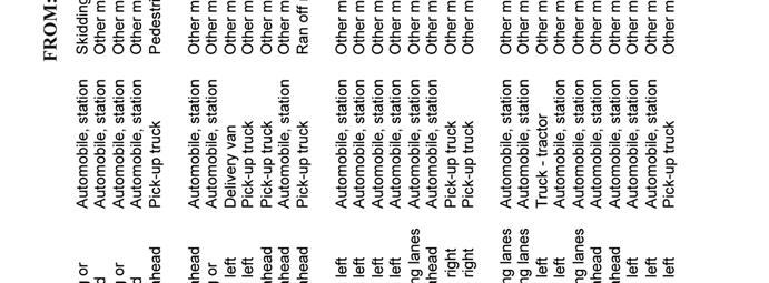
21 Site Circulation of Traffic The proposed Site Plan shows an efficient movement of vehicles entering from St. Patrick Street and exiting onto Murray Street. The site s exit onto Murray Street provides a clear throat distance of approximately 1 vehicle. The 2022 analysis determined that the 95 th percentile queue at the exit was 0.62 vehicles which would result in the queueing at the site exit to not interfere with the operation of the exit from the parking garage. 4.4 Collision Reports A three year collision report summary was obtained from the City of Ottawa for the year 2011 through 2013 at the St. Patrick/King Edward and Murray/King Edward intersections. The reports determined that at the St. Patrick/King Edward intersection there were 47 reported collisions over the three year time period. Of the 47 collisions, 5 were angular collisions which are collisions which may be reduced by the installation of traffic signals or modifications to the intersection. At the Murray/King Edward intersection there were 27 reported collisions over the three year time period of which 4 were angular collisions. Table 4.5 summarizes the types of collisions reported at the intersections over the three year period, with the City of Ottawa collision reports provided in the Appendix as Exhibit 19. The collision reports do not indicate the need for modifications to the St. Patrick/King Edward or Murray/King Edward intersections. The relatively low volume of traffic generated by the site would result in a negligible impact on the collisions reported at the intersections. Murray/King Edward Intersection TABLE 4.5 COLLISION SUMMARY COLLISION DATA Year Rear-End Angular Turning Other Total St. Patrick/King Edward Intersection Year Rear-End Angular Turning Other Total
22 Transportation Demand Management (TDM) The City of Ottawa is implementing Transportation Demand Management (TDM) measures as a plan to reduce peak hour traffic along the City s transportation network. Although the site is a hotel with patrons unfamiliar with the area, the Site Plan does serve the principals of TDM by locating the site in close proximity to pedestrian, cycling and transit facilities. The following lists the facilities which would reduce the volumes of peak hour vehicular traffic: 1. Sidewalks currently exist along both sides of St. Patrick Street, Murray Street and King Edward Avenue. The main entrance to the hotel is from King Edward Avenue and the driveway which enters from St. Patrick Street and exits onto Murray Street. The main access to the building will have direct access to the existing municipal sidewalks on King Edward Avenue, and along St. Patrick Street and Murray Street from the driveway. Patrons of the hotel would have good access to the downtown municipal sidewalk system. 2. OC Transpo Regular Service Route #1 travels westbound along St. Patrick Street past the site and eastbound along Murray Street. The route provides access to the downtown area with bus stops within a short walking distance from the site. 3. The Holiday Inn hotel would provide bicycle racks which would be used mainly by employees of the hotel. St. Patrick Street is identified in the City of Ottawa TMP as an On-road Cycling Route. 5. FINDINGS Momentum Planning and Communications has proposed the development of lands at 235 King Edward Avenue. The lands currently contain a parking lot with a residential building. The site has access directly onto St. Patrick Street. The site is hectares in size and is located at the southeast corner of the intersection of St. Patrick Street and King Edward Avenue. The Site Plan proposes a 167 room Holiday Inn hotel with banquet and meeting space and a restaurant. All parking will be contained on the site in an underground parking garage providing 79 spaces, and a 5 space short term surface parking with lay-by at the hotel entrance. The hotel site will have one entrance from St. Patrick Street and one exit onto Murray Street. The study analysis has examined the entrance and exit from the site, and the St. Patrick/King Edward and Murray/King Edward intersections for the impact of the site during the weekday peak PM hour and Saturday peak hour of the adjacent roads. The site is expected to be completed and open to the public by the year The findings and recommendations of the study are summarized in the following: 1) The trip generation analysis determined that the hotel site would generate 57 vehicles entering and 60 vehicles exiting the site during the peak PM hour, and 73 vehicles entering and 73 vehicles exiting during the Saturday peak hour.
23 21 2) The proposed site would have one entrance onto St. Patrick Street and one egress onto Murray Street. The entrance would be located approximately 35 metres from the stop bar at the westbound St. Patrick Street approach to the St. Patrick/King Edward intersection. The operational analysis determined that during peak hours the westbound queue from the St. Patrick/King Edward intersection may periodically extend past the site entrance resulting in a delay for vehicles entering the site. The queue would dissipate after every traffic signal cycle. The St. Patrick Street entrance and Murray Street exit would be constructed as a private approach with all movements operating at a good level of service. 3) The intersection of St. Patrick Street and King Edward Avenue was examined for the existing traffic counts, for the expected traffic at 2017 when substantial completion of the site is expected, and at 2022 which represents five years beyond completion. The analysis determined that for the peak PM and Saturday peak hours the intersection would operate at an acceptable level of service. With the exception of adjustments to traffic signal timing, there would be no modifications to the intersection required due to the development of the site as a hotel. 4) The intersection of Murray Street and King Edward Avenue was examined and it was determined to operate at an acceptable level of service for the existing traffic volumes. As the volume of background traffic increases, the intersection was determined to operate at a Level of Service (LoS) D for the 2017 traffic, and at a LoS E at the year The hotel development would contribute few trips when compared to the total expected traffic which would result in the hotel having a minor impact on the operation of the intersection. There would be no modifications to the intersection required due to the development of the site as a hotel. 5) A Check List is provided in the Appendix as Exhibit 20. Prepared by: David J. Halpenny, P. Eng.
24 22 APPENDIX TRAFFIC COUNTS OPERATIONAL ANALYSIS WORK SHEETS COLLISION REPORTS TRANSPORTATION BRIEF - CHECK LIST
25 23 EXHIBIT WEEKDAY PEAK PM HOUR TRAFFIC COUNTS King Edward/St. Patrick
26 24 EXHIBIT SATURDAY PEAK HOUR TRAFFIC COUNTS King Edward/St. Patrick
27 25 EXHIBIT WEEKDAY PEAK PM HOUR TRAFFIC COUNTS King Edward/Murray
28 26 EXHIBIT PEAK PM HOUR TOTAL TRAFFIC ANALYSIS Entrance/St. Patrick HCS+: Unsignalized Intersections Release 5.6 TWO-WAY STOP CONTROL SUMMARY Analysis Time Period: Peak PM Hour Intersection: Site Access/St. Patrick Analysis Year: Year 2017 Project ID: Hotel St. Patrick Street East/West Street: St. Patrick Street North/South Street: Site Access Intersection Orientation: EW Study period (hrs): 0.25 Vehicle Volumes and Adjustments Major Street: Approach Eastbound Westbound Movement L T R L T R Volume Peak-Hour Factor, PHF Hourly Flow Rate, HFR Percent Heavy Vehicles Median Type/Storage Undivided / RT Channelized? Lanes 0 2 Configuration LT T Upstream Signal? No No Minor Street: Approach Northbound Southbound Movement L T R L T R Volume Peak Hour Factor, PHF Hourly Flow Rate, HFR Percent Heavy Vehicles Percent Grade (%) 0 0 Flared Approach: Exists?/Storage / / Lanes Configuration Delay, Queue Length, and Level of Service Approach EB WB Northbound Southbound Movement Lane Config LT v (vph) 61 C(m) (vph) 1636 v/c % queue length 0.12 Control Delay 7.3 LOS A Approach Delay Approach LOS
29 27 EXHIBIT SATURDAY PEAK HOUR TOTAL TRAFFIC ANALYSIS Entrance/St. Patrick HCS+: Unsignalized Intersections Release 5.6 TWO-WAY STOP CONTROL SUMMARY Analysis Time Period: Saturday Peak Hour Intersection: Site Access/St. Patrick Analysis Year: Year 2017 Project ID: Hotel St. Patrick Street East/West Street: St. Patrick Street North/South Street: Site Access Intersection Orientation: EW Study period (hrs): 0.25 Vehicle Volumes and Adjustments Major Street: Approach Eastbound Westbound Movement L T R L T R Volume Peak-Hour Factor, PHF Hourly Flow Rate, HFR Percent Heavy Vehicles Median Type/Storage Undivided / RT Channelized? Lanes 0 2 Configuration LT T Upstream Signal? No No Minor Street: Approach Northbound Southbound Movement L T R L T R Volume Peak Hour Factor, PHF Hourly Flow Rate, HFR Percent Heavy Vehicles Percent Grade (%) 0 0 Flared Approach: Exists?/Storage / / Lanes Configuration Delay, Queue Length, and Level of Service Approach EB WB Northbound Southbound Movement Lane Config LT v (vph) 79 C(m) (vph) 1636 v/c % queue length 0.15 Control Delay 7.3 LOS A Approach Delay Approach LOS
30 28 EXHIBIT PEAK PM HOUR TOTAL TRAFFIC ANALYSIS Entrance/St. Patrick HCS+: Unsignalized Intersections Release 5.6 TWO-WAY STOP CONTROL SUMMARY Analysis Time Period: Peak PM Hour Intersection: Site Access/St. Patrick Analysis Year: Year 2022 Project ID: Hotel St. Patrick Street East/West Street: St. Patrick Street North/South Street: Site Access Intersection Orientation: EW Study period (hrs): 0.25 Vehicle Volumes and Adjustments Major Street: Approach Eastbound Westbound Movement L T R L T R Volume Peak-Hour Factor, PHF Hourly Flow Rate, HFR Percent Heavy Vehicles Median Type/Storage Undivided / RT Channelized? Lanes 0 2 Configuration LT T Upstream Signal? No No Minor Street: Approach Northbound Southbound Movement L T R L T R Volume Peak Hour Factor, PHF Hourly Flow Rate, HFR Percent Heavy Vehicles Percent Grade (%) 0 0 Flared Approach: Exists?/Storage / / Lanes Configuration Delay, Queue Length, and Level of Service Approach EB WB Northbound Southbound Movement Lane Config LT v (vph) 61 C(m) (vph) 1636 v/c % queue length 0.12 Control Delay 7.3 LOS A Approach Delay Approach LOS
31 29 EXHIBIT SATURDAY PEAK HOUR TOTAL TRAFFIC ANALYSIS Entrance/St. Patrick HCS+: Unsignalized Intersections Release 5.6 TWO-WAY STOP CONTROL SUMMARY Analysis Time Period: Saturday Peak Hour Intersection: Site Access/St. Patrick Analysis Year: Year 2022 Project ID: Hotel St. Patrick Street East/West Street: St. Patrick Street North/South Street: Site Access Intersection Orientation: EW Study period (hrs): 0.25 Vehicle Volumes and Adjustments Major Street: Approach Eastbound Westbound Movement L T R L T R Volume Peak-Hour Factor, PHF Hourly Flow Rate, HFR Percent Heavy Vehicles Median Type/Storage Undivided / RT Channelized? Lanes 0 2 Configuration LT T Upstream Signal? No No Minor Street: Approach Northbound Southbound Movement L T R L T R Volume Peak Hour Factor, PHF Hourly Flow Rate, HFR Percent Heavy Vehicles Percent Grade (%) 0 0 Flared Approach: Exists?/Storage / / Lanes Configuration Delay, Queue Length, and Level of Service Approach EB WB Northbound Southbound Movement Lane Config LT v (vph) 79 C(m) (vph) 1636 v/c % queue length 0.15 Control Delay 7.3 LOS A Approach Delay Approach LOS
32 30 EXHIBIT PEAK PM HOUR TOTAL TRAFFIC ANALYSIS Exit/Murray HCS+: Unsignalized Intersections Release 5.6 TWO-WAY STOP CONTROL SUMMARY Analysis Time Period: Peak PM Hour Intersection: Site Access/Murray Analysis Year: Year 2017 Project ID: Hotel St. Patrick Street East/West Street: Murray Street North/South Street: Site Access Intersection Orientation: EW Study period (hrs): 0.25 Vehicle Volumes and Adjustments Major Street: Approach Eastbound Westbound Movement L T R L T R Volume 1271 Peak-Hour Factor, PHF 0.92 Hourly Flow Rate, HFR 1381 Percent Heavy Vehicles Median Type/Storage Undivided / RT Channelized? Lanes 2 Configuration T Upstream Signal? No No Minor Street: Approach Northbound Southbound Movement L T R L T R Volume 60 Peak Hour Factor, PHF 0.92 Hourly Flow Rate, HFR 65 Percent Heavy Vehicles 0 Percent Grade (%) 0 0 Flared Approach: Exists?/Storage / / Lanes 1 Configuration L Delay, Queue Length, and Level of Service Approach EB WB Northbound Southbound Movement Lane Config L v (vph) 65 C(m) (vph) 414 v/c % queue length 0.55 Control Delay 15.3 LOS C Approach Delay 15.3 Approach LOS C
33 31 EXHIBIT PEAK PM HOUR TOTAL TRAFFIC ANALYSIS Exit/Murray HCS+: Unsignalized Intersections Release 5.6 TWO-WAY STOP CONTROL SUMMARY Analysis Time Period: Peak PM Hour Intersection: Site Access/Murray Analysis Year: Year 2022 Project ID: Hotel St. Patrick Street East/West Street: Murray Street North/South Street: Site Access Intersection Orientation: EW Study period (hrs): 0.25 Vehicle Volumes and Adjustments Major Street: Approach Eastbound Westbound Movement L T R L T R Volume 1397 Peak-Hour Factor, PHF 0.92 Hourly Flow Rate, HFR 1518 Percent Heavy Vehicles Median Type/Storage Undivided / RT Channelized? Lanes 2 Configuration T Upstream Signal? No No Minor Street: Approach Northbound Southbound Movement L T R L T R Volume 60 Peak Hour Factor, PHF 0.92 Hourly Flow Rate, HFR 65 Percent Heavy Vehicles 0 Percent Grade (%) 0 0 Flared Approach: Exists?/Storage / / Lanes 1 Configuration L Delay, Queue Length, and Level of Service Approach EB WB Northbound Southbound Movement Lane Config L v (vph) 65 C(m) (vph) 377 v/c % queue length 0.62 Control Delay 16.5 LOS C Approach Delay 16.5 Approach LOS C
34 32 EXHIBIT PEAK PM HOUR EXISTING TRAFFIC ANALYSIS King Edward/St. Patrick HCS+: Signalized Intersections Release 5.4 Analyst: Inter.: St. Patrick/King Edward Period: Peak PM Hour Year: Year 2009 Project ID: Hotel St. Patrick Street E/W St: St. Patrick Street N/S St: King Edward Avenue SIGNALIZED INTERSECTION SUMMARY Eastbound Westbound Northbound Southbound L T R L T R L T R L T R No. Lanes LGConfig LT R T TR Volume Lane Width RTOR Vol 0 0 _ Duration 0.25 Area Type: All other areas Signal Operations Phase Combination EB NB Thru Thru P Peds X Peds X WB A SB Thru A Thru P A A P A Peds X Peds X X NB EB SB WB A Green Yellow All Red Cycle Length: secs CAPACITY AND LOS WORKSHEET Capacity Analysis and Lane Group Capacity Adj Adj Sat Flow Green --Lane Group-- Appr/ Lane Flow Rate Flow Rate Ratio Ratio Capacity v/c Mvmt Group (v) (s) (v/s) (g/c) (c) Ratio _ Eastbound Thru Westbound Thru LT R # Northbound Thru T # Southbound Thru TR _ Sum of flow ratios for critical lane groups, Yc = Sum (v/s) = 0.59 Total lost time per cycle, L = sec Critical flow rate to capacity ratio, Xc = (Yc)(C)/(C-L) = 0.57
35 33 EXHIBIT SAT. PEAK HOUR EXISTING TRAFFIC ANALYSIS King Edward/St. Patrick HCS+: Signalized Intersections Release 5.4 Analyst: Inter.: St. Patrick/King Edward Period: Saturday Peak Hour Year: Year 2014 Project ID: Hotel St. Patrick Street E/W St: St. Patrick Street N/S St: King Edward Avenue SIGNALIZED INTERSECTION SUMMARY Eastbound Westbound Northbound Southbound L T R L T R L T R L T R No. Lanes LGConfig LT R T TR Volume Lane Width RTOR Vol 0 0 _ Duration 0.25 Area Type: All other areas Signal Operations Phase Combination EB NB Thru Thru P Peds X Peds X WB A SB Thru A Thru P A A P A Peds X Peds X X NB EB SB WB A Green Yellow All Red Cycle Length: secs CAPACITY AND LOS WORKSHEET Capacity Analysis and Lane Group Capacity Adj Adj Sat Flow Green --Lane Group-- Appr/ Lane Flow Rate Flow Rate Ratio Ratio Capacity v/c Mvmt Group (v) (s) (v/s) (g/c) (c) Ratio _ Eastbound Thru Westbound Thru LT # R Northbound Thru T Southbound Thru TR # _ Sum of flow ratios for critical lane groups, Yc = Sum (v/s) = 0.41 Total lost time per cycle, L = 1.90 sec Critical flow rate to capacity ratio, Xc = (Yc)(C)/(C-L) = 0.41
36 34 EXHIBIT PEAK PM HOUR TOTAL TRAFFIC ANALYSIS King Edward/St. Patrick HCS+: Signalized Intersections Release 5.4 Analyst: Inter.: St. Patrick/King Edward Period: Peak PM Hour Year: Year 2017 Project ID: Hotel St. Patrick Street E/W St: St. Patrick Street N/S St: King Edward Avenue SIGNALIZED INTERSECTION SUMMARY Eastbound Westbound Northbound Southbound L T R L T R L T R L T R No. Lanes LGConfig LT R T TR Volume Lane Width RTOR Vol 0 0 _ Duration 0.25 Area Type: All other areas Signal Operations Phase Combination EB NB Thru Thru P Peds X Peds X WB A SB Thru A Thru P A A P A Peds X Peds X X NB EB SB WB A Green Yellow All Red Cycle Length: secs CAPACITY AND LOS WORKSHEET Capacity Analysis and Lane Group Capacity Adj Adj Sat Flow Green --Lane Group-- Appr/ Lane Flow Rate Flow Rate Ratio Ratio Capacity v/c Mvmt Group (v) (s) (v/s) (g/c) (c) Ratio _ Eastbound Thru Westbound Thru LT R # Northbound Thru T # Southbound Thru TR _ Sum of flow ratios for critical lane groups, Yc = Sum (v/s) = 0.70 Total lost time per cycle, L = sec Critical flow rate to capacity ratio, Xc = (Yc)(C)/(C-L) = 0.67
37 35 EXHIBIT SAT. PEAK HOUR TOTAL TRAFFIC ANALYSIS King Edward/St. Patrick HCS+: Signalized Intersections Release 5.4 Analyst: Inter.: St. Patrick/King Edward Period: Saturday Peak Hour Year: Year 2017 Project ID: Hotel St. Patrick Street E/W St: St. Patrick Street N/S St: King Edward Avenue SIGNALIZED INTERSECTION SUMMARY Eastbound Westbound Northbound Southbound L T R L T R L T R L T R No. Lanes LGConfig LT R T TR Volume Lane Width RTOR Vol 0 0 _ Duration 0.25 Area Type: All other areas Signal Operations Phase Combination EB NB Thru Thru P Peds X Peds X WB A SB Thru A Thru P A A P A Peds X Peds X X NB EB SB WB A Green Yellow All Red Cycle Length: secs CAPACITY AND LOS WORKSHEET Capacity Analysis and Lane Group Capacity Adj Adj Sat Flow Green --Lane Group-- Appr/ Lane Flow Rate Flow Rate Ratio Ratio Capacity v/c Mvmt Group (v) (s) (v/s) (g/c) (c) Ratio _ Eastbound Thru Westbound Thru LT # R Northbound Thru T Southbound Thru TR # _ Sum of flow ratios for critical lane groups, Yc = Sum (v/s) = 0.45 Total lost time per cycle, L = 1.90 sec Critical flow rate to capacity ratio, Xc = (Yc)(C)/(C-L) = 0.46
38 36 EXHIBIT PEAK PM HOUR TOTAL TRAFFIC ANALYSIS King Edward/St. Patrick HCS+: Signalized Intersections Release 5.4 Analyst: Inter.: St. Patrick/King Edward Period: Peak PM Hour Year: Year 2022 Project ID: Hotel St. Patrick Street E/W St: St. Patrick Street N/S St: King Edward Avenue SIGNALIZED INTERSECTION SUMMARY Eastbound Westbound Northbound Southbound L T R L T R L T R L T R No. Lanes LGConfig LT R T TR Volume Lane Width RTOR Vol 0 0 _ Duration 0.25 Area Type: All other areas Signal Operations Phase Combination EB NB Thru Thru P Peds X Peds X WB A SB Thru A Thru P A A P A Peds X Peds X X NB EB SB WB A Green Yellow All Red Cycle Length: secs CAPACITY AND LOS WORKSHEET Capacity Analysis and Lane Group Capacity Adj Adj Sat Flow Green --Lane Group-- Appr/ Lane Flow Rate Flow Rate Ratio Ratio Capacity v/c Mvmt Group (v) (s) (v/s) (g/c) (c) Ratio _ Eastbound Thru Westbound Thru LT R # Northbound Thru T # Southbound Thru TR _ Sum of flow ratios for critical lane groups, Yc = Sum (v/s) = 0.77 Total lost time per cycle, L = sec Critical flow rate to capacity ratio, Xc = (Yc)(C)/(C-L) = 0.74
39 37 EXHIBIT SAT. PEAK HOUR TOTAL TRAFFIC ANALYSIS King Edward/St. Patrick HCS+: Signalized Intersections Release 5.4 Analyst: Inter.: St. Patrick/King Edward Period: Saturday Peak Hour Year: Year 2022 Project ID: Hotel St. Patrick Street E/W St: St. Patrick Street N/S St: King Edward Avenue SIGNALIZED INTERSECTION SUMMARY Eastbound Westbound Northbound Southbound L T R L T R L T R L T R No. Lanes LGConfig LT R T TR Volume Lane Width RTOR Vol 0 0 _ Duration 0.25 Area Type: All other areas Signal Operations Phase Combination EB NB Thru Thru P Peds X Peds X WB A SB Thru A Thru P A A P A Peds X Peds X X NB EB SB WB A Green Yellow All Red Cycle Length: secs CAPACITY AND LOS WORKSHEET Capacity Analysis and Lane Group Capacity Adj Adj Sat Flow Green --Lane Group-- Appr/ Lane Flow Rate Flow Rate Ratio Ratio Capacity v/c Mvmt Group (v) (s) (v/s) (g/c) (c) Ratio _ Eastbound Thru Westbound Thru LT # R Northbound Thru T Southbound Thru TR # _ Sum of flow ratios for critical lane groups, Yc = Sum (v/s) = 0.48 Total lost time per cycle, L = 1.90 sec Critical flow rate to capacity ratio, Xc = (Yc)(C)/(C-L) = 0.49
40 38 EXHIBIT PEAK PM HOUR EXISTING TRAFFIC ANALYSIS King Edward/Murray HCS+: Signalized Intersections Release 5.4 Analyst: Inter.: Murray/King Edward Period: Peak PM Hour Year: Year 2014 Project ID: Hotel St. Patrick Street E/W St: Murray Street N/S St: King Edward Avenue SIGNALIZED INTERSECTION SUMMARY Eastbound Westbound Northbound Southbound L T R L T R L T R L T R No. Lanes LGConfig L LTR TR L T Volume Lane Width RTOR Vol 0 0 _ Duration 0.25 Area Type: All other areas Signal Operations Phase Combination EB A NB Thru A Thru P A P Peds X Peds X WB SB A Thru Thru P A Peds Peds X X NB EB SB WB Green Yellow All Red Cycle Length: secs CAPACITY AND LOS WORKSHEET Capacity Analysis and Lane Group Capacity Adj Adj Sat Flow Green --Lane Group-- Appr/ Lane Flow Rate Flow Rate Ratio Ratio Capacity v/c Mvmt Group (v) (s) (v/s) (g/c) (c) Ratio _ Eastbound L Thru LTR # Westbound Thru Northbound Thru TR # Southbound L # Thru T _ Sum of flow ratios for critical lane groups, Yc = Sum (v/s) = 0.67 Total lost time per cycle, L = sec Critical flow rate to capacity ratio, Xc = (Yc)(C)/(C-L) = 0.77
41 39 EXHIBIT PEAK PM HOUR TOTAL TRAFFIC ANALYSIS King Edward/Murray HCS+: Signalized Intersections Release 5.4 Analyst: Inter.: Murray/King Edward Period: Peak PM Hour Year: Year 2017 Project ID: Hotel St. Patrick Street E/W St: Murray Street N/S St: King Edward Avenue SIGNALIZED INTERSECTION SUMMARY Eastbound Westbound Northbound Southbound L T R L T R L T R L T R No. Lanes LGConfig L LTR TR L T Volume Lane Width RTOR Vol 0 0 _ Duration 0.25 Area Type: All other areas Signal Operations Phase Combination EB A NB Thru A Thru P A P Peds X Peds X WB SB A Thru Thru P A Peds Peds X X NB EB SB WB Green Yellow All Red Cycle Length: secs CAPACITY AND LOS WORKSHEET Capacity Analysis and Lane Group Capacity Adj Adj Sat Flow Green --Lane Group-- Appr/ Lane Flow Rate Flow Rate Ratio Ratio Capacity v/c Mvmt Group (v) (s) (v/s) (g/c) (c) Ratio _ Eastbound L Thru LTR # Westbound Thru Northbound Thru TR # Southbound L # Thru T _ Sum of flow ratios for critical lane groups, Yc = Sum (v/s) = 0.72 Total lost time per cycle, L = sec Critical flow rate to capacity ratio, Xc = (Yc)(C)/(C-L) = 0.84
42 40 EXHIBIT PEAK PM HOUR TOTAL TRAFFIC ANALYSIS King Edward/Murray HCS+: Signalized Intersections Release 5.4 Analyst: Inter.: Murray/King Edward Period: Peak PM Hour Year: Year 2022 Project ID: Hotel St. Patrick Street E/W St: Murray Street N/S St: King Edward Avenue SIGNALIZED INTERSECTION SUMMARY Eastbound Westbound Northbound Southbound L T R L T R L T R L T R No. Lanes LGConfig L LTR TR L T Volume Lane Width RTOR Vol 0 0 _ Duration 0.25 Area Type: All other areas Signal Operations Phase Combination EB A NB Thru A Thru P A P Peds X Peds X WB SB A Thru Thru P A Peds Peds X X NB EB SB WB Green Yellow All Red Cycle Length: secs CAPACITY AND LOS WORKSHEET Capacity Analysis and Lane Group Capacity Adj Adj Sat Flow Green --Lane Group-- Appr/ Lane Flow Rate Flow Rate Ratio Ratio Capacity v/c Mvmt Group (v) (s) (v/s) (g/c) (c) Ratio _ Eastbound L Thru LTR # Westbound Thru Northbound Thru TR # Southbound L # Thru T _ Sum of flow ratios for critical lane groups, Yc = Sum (v/s) = 0.79 Total lost time per cycle, L = sec Critical flow rate to capacity ratio, Xc = (Yc)(C)/(C-L) = 0.92

43 41 EXHIBIT 19 COLLISION REPORTS King Edward/St. Patrick
44 42
45 43

46 44
47 45

48 46
INDUSTRIAL BUILDING 3009 HAWTHORNE ROAD CITY OF OTTAWA TRANSPORTATION OVERVIEW REVISED. Prepared for: Canada Inc.
 INDUSTRIAL BUILDING 3009 HAWTHORNE ROAD CITY OF OTTAWA TRANSPORTATION OVERVIEW REVISED Prepared for: 7849648 Canada Inc. Octiober 1, 2015 114-598 Overview_2.doc D. J. Halpenny & Associates Ltd. Consulting
FAIRFIELD INN & SUITES HOTEL 135 THAD JOHNSON PRIVATE OTTAWA TRANSPORTATION BRIEF. Prepared for:
 FAIRFIELD INN & SUITES HOTEL 135 THAD JOHNSON PRIVATE OTTAWA TRANSPORTATION BRIEF Prepared for: Bona Building & Management Co. Ltd. Place Vanier, 333 North River Road Vanier, Ontario K1L 8B9 August 12,
OFFICE/RETAIL DEVELOPMENT 1625 BANK STREET OTTAWA, ONTARIO TRANSPORTATION BRIEF. Prepared for: Canada Inc.
 OFFICE/RETAIL DEVELOPMENT 1625 BANK STREET OTTAWA, ONTARIO TRANSPORTATION BRIEF Prepared for: 9402209 Canada Inc. December 15, 2015 115-625 Report_2.doc D. J. Halpenny & Associates Ltd. Consulting Transportation
HILTON GARDEN INN HOTEL HOTEL EXPANSION 2400 ALERT ROAD, OTTAWA TRANSPORTATION BRIEF. Prepared for:
 HILTON GARDEN INN HOTEL HOTEL EXPANSION 2400 ALERT ROAD, OTTAWA TRANSPORTATION BRIEF Prepared for: Bona Building & Management Co. Ltd. Place Vanier, 333 North River Road Vanier, Ontario K1L 8B9 October
APARTMENT BUILDING DEVELOPMENT 1161 HERON ROAD OTTAWA, ONTARIO TRANSPORTATION IMPACT STUDY. Prepared for:
 APARTMENT BUILDING DEVELOPMENT 1161 HERON ROAD OTTAWA, ONTARIO TRANSPORTATION IMPACT STUDY Prepared for: 1649362 Ontario Inc. c/o Manor Park Management 231 Brittany Drive, Suite D Ottawa ON K1K 0R8 July
INDUSTRIAL BUILDING 1660 COMSTOCK ROAD CITY OF OTTAWA TRANSPORTATION OVERVIEW. Prepared for:
 INDUSTRIAL BUILDING 1660 COMSTOCK ROAD CITY OF OTTAWA TRANSPORTATION OVERVIEW Prepared for: Simluc Contractors Limited 2550 Blackwell Street, Ottawa K1B 5R1 October 18, 2013 113-584 Overview_1.doc D. J.
MEDICAL/OFFICE BUILDING 1637 BANK STREET OTTAWA, ONTARIO TRANSPORTATION OVERVIEW. Prepared for:
 MEDICAL/OFFICE BUILDING 1637 BANK STREET OTTAWA, ONTARIO TRANSPORTATION OVERVIEW Prepared for: 2434984 Ontario Inc. 13-5510 Canotek Road Ottawa, Ontario K1J 9J5 June 4, 2015 115-613 Report_2.doc D. J.
MEETING FACILITY 2901 GIBFORD DRIVE CITY OF OTTAWA TRANSPORTATION BRIEF. Prepared for: Holiday Inn Express 2881 Gibford Drive Ottawa, ON K1V 2L9
 MEETING FACILITY 2901 GIBFORD DRIVE CITY OF OTTAWA TRANSPORTATION BRIEF Prepared for: Holiday Inn Express 2881 Gibford Drive Ottawa, ON K1V 2L9 December 18, 2012 112-566 Brief_1.doc D. J. Halpenny & Associates
URBAN QUARRY HEADQUARTERS 2717 STEVENAGE DRIVE CITY OF OTTAWA TRANSPORTATION OVERVIEW. Prepared for: Urban Quarry 4123 Belgreen Drive, Ottawa K1G 3N2
 URBAN QUARRY HEADQUARTERS 2717 STEVENAGE DRIVE CITY OF OTTAWA TRANSPORTATION OVERVIEW Prepared for: Urban Quarry 4123 Belgreen Drive, Ottawa K1G 3N2 February 27, 2014 113-584 Overview_1.doc D. J. Halpenny
QUICKIE C STORE AND GAS BAR 1780 HERON ROAD OTTAWA, ONTARIO TRANSPORTATION BRIEF. Prepared for:
 QUICKIE C STORE AND GAS BAR 1780 HERON ROAD OTTAWA, ONTARIO TRANSPORTATION BRIEF Prepared for: Quickie Convenience Stores Larny Holdings Ltd. c/o PBC Group April 15, 2015 115-615 Report_1.doc D. J. Halpenny
OTTAWA TRAIN YARDS PHASE 3 DEVELOPMENT CITY OF OTTAWA TRANSPORTATION IMPACT STUDY. Prepared for:
 OTTAWA TRAIN YARDS PHASE 3 DEVELOPMENT CITY OF OTTAWA TRANSPORTATION IMPACT STUDY Prepared for: The Ottawa Train Yards Inc. 223 Colonnade Road South, Suite 212 Nepean, Ontario K2E 7K3 January 17, 2012
ORLEANS GARDENS SHOPPING CENTRE 1615 ORLEANS BOULEVARD CITY OF OTTAWA, ONTARIO TRANSPORTATION IMPACT STUDY. Prepared for:
 ORLEANS GARDENS SHOPPING CENTRE 1615 ORLEANS BOULEVARD CITY OF OTTAWA, ONTARIO TRANSPORTATION IMPACT STUDY Prepared for: Orleans Gardens Shopping Centre Inc. 2851 John Street, Suite 1 Markham, ON K3R 5R7
HENDERSON DEVELOPMENT 213, 217, 221, 221 ½, 223 HENDERSON AVENUE and 65 TEMPLETON STREET OTTAWA, ONTARIO TRANSPORTATION OVERVIEW.
 HENDERSON DEVELOPMENT 213, 217, 221, 221 ½, 223 HENDERSON AVENUE and 65 TEMPLETON STREET OTTAWA, ONTARIO TRANSPORTATION OVERVIEW Prepared for: 2294170 Ontario Inc. February 2, 2017 117-652 Report_1.doc
COMMERCIAL DEVELOPMENT 2015 ROBERTSON ROAD OTTAWA, ONTARIO TRANSPORTATION BRIEF. Prepared for:
 COMMERCIAL DEVELOPMENT 2015 ROBERTSON ROAD OTTAWA, ONTARIO TRANSPORTATION BRIEF Prepared for: First Bay Properties Inc. 311 Richmond Road, Suite 203 Ottawa, ON K1Z 6X3 August 8, 2017 117-663 Brief_1.doc
NEW YORK CENTRAL PARK SUBDIVISION BLAIS STREET/ST-PIERRE STREET EMBRUN, ONTARIO TRAFFIC IMPACT STUDY. Prepared for:
 NEW YORK CENTRAL PARK SUBDIVISION BLAIS STREET/ST-PIERRE STREET EMBRUN, ONTARIO TRAFFIC IMPACT STUDY Prepared for: Solidex Holdings Limited & Investissement Maurice Lemieux Investments Attn: Mr. Anthony
BLUE SEA VILLAGE MER BLEUE 2159 MER BLEUE ROAD OTTAWA, ONTARIO TRANSPORTATION IMPACT ASSESSMENT. Prepared for: Ontario Limited.
 BLUE SEA VILLAGE MER BLEUE 2159 MER BLEUE ROAD OTTAWA, ONTARIO TRANSPORTATION IMPACT ASSESSMENT Prepared for: 2534189 Ontario Limited April 6, 2018 117-668 TIA Report_2.doc D. J. Halpenny & Associates
The proposed development is located within 800m of an existing Transit Station where infill developments and intensification are encouraged.
 Stantec Consulting Ltd. 1331 Clyde Avenue, Suite 4 Ottawa ON K2C 3G4 Tel: (613) 722-442 Fax: (613) 722-2799 May 14, 213 File: 1638823 Robinson Park Development Corp. 5699 Power Road Ottawa, ON, K1G 3N4
9 Leeming Drive Redevelopment Ottawa, ON Transportation Brief. Prepared By: Stantec Consulting Ltd.
 9 Leeming Drive Redevelopment Ottawa, ON Transportation Brief Prepared By: Stantec Consulting Ltd. TIA GUIDELINES CHECKLIST Report Context Municipal Address Comment: Section 1.1 Location relative to major
Traffic Impact Study. Roderick Place Columbia Pike Thompson s Station, TN. Transportation Group, LLC Traffic Engineering and Planning
 F i s c h b a c h Transportation Group, LLC Traffic Engineering and Planning Traffic Impact Study Roderick Place Columbia Pike Thompson s Station, TN Prepared March 2016 Ms. Gillian L. Fischbach, P.E.,
Traffic Impact Analysis Chatham County Grocery Chatham County, NC
 Chatham County Grocery Chatham County, NC TABLE OF CONTENTS 1. INTRODUCTION... 1 1.1. Location and Study Area... 1 1.2. Proposed Land Use and Access... 2 1.3. Adjacent Land Uses... 2 1.4. Existing ways...
REDEVELOPMENT TRAFFIC IMPACT STUDY
 REDEVELOPMENT TRAFFIC IMPACT STUDY For Wendy s Parker, Colorado January 215 Prepared for: Sterling Design Associates, LLC 29 W. Littleton Boulevard #3 Littleton, Colorado 812 Prepared by: 1233 Airport
List of Exhibits...ii
 One Brickell Traffic Study TABLE OF CONTENTS List of Exhibits...ii EXECUTIVE SUMMARY...1 1. INTRODUCTION...2 1.1 Study Area...2 1.2 Study Objective...5 2. EXISTING TRAFFIC CONDITIONS...6 2.1 Data Collection...6
Signal Warrant Studies
 Signal Warrant Studies Seven Locations Piqua, Ohio December 12, 217 Signal Warrant Studies Seven Locations Piqua, Ohio TABLE OF CONTENTS Executive Summary... 3 Introduction... 5 Study Location... 5 Data
VIVA RETIREMENT COMMUNITIES OAKVILLE TRAFFIC IMPACT STUDY
 VIVA RETIREMENT COMMUNITIES OAKVILLE TRAFFIC IMPACT STUDY VIVA RETIREMENT COMMUNITIES OAKVILLE TRAFFIC IMPACT STUDY DECEMBER 2012 READ, VOORHEES & ASSOCIATES TORONTO, ONTARIO Read, Voorhees & Associates
Harrah s Station Square Casino
 Transportation Analysis Harrah s Station Square Casino Pittsburgh, Pennsylvania Submitted To: City of Pittsburgh and Pennsylvania Gaming Control Board Prepared By: DKS Associates GAI Consultants December
CPC Parking Lot Riverside Drive. Transportation Brief
 CPC Parking Lot 2785 Riverside Drive Transportation Brief Prepared By: NOVATECH Suite 2, 24 Michael Cowpland Drive Ottawa, Ontario K2M P6 7 / 5 / 25 Novatech File: 49 Ref: R-25-22 July 5 th, 25 City of
EXECUTIVE SUMMARY. Page 1 of 6
 EXECUTIVE SUMMARY The purpose of this report is to identify conformance with the original traffic impact study for the proposed retail development on Lot 5 of Riverdale Retail Filing No. 1 located on the
5858 N COLLEGE, LLC N College Avenue Traffic Impact Study
 5858 N COLLEGE, LLC nue Traffic Impact Study August 22, 2016 Contents Traffic Impact Study Page Preparer Qualifications... 1 Introduction... 2 Existing Roadway Conditions... 5 Existing Traffic Conditions...
Place Vanier 250 Montreal Road Transportation Impact Study Addendum. Prepared for Broccolini Construction September 20 th, 2012
 Update for the May 31 st, 2012 Traffic Impact Study Prepared for Broccolini Construction 111-23596-00 September 20 th, 2012 2611 Queensview Drive, Suite 300, Ottawa, Ontario CANADA K2B 8K2 Telephone: 613-829-2800
Traffic Impact Study WestBranch Residential Development Davidson, NC March 2016
 Traffic Impact Study WestBranch Residential Development Davidson, NC March 216 TRAFFIC IMPACT STUDY FOR THE WestBranch Residential Development LOCATED IN DAVIDSON, NC Prepared For: Lennar Carolinas, LLC
Draft Report. Traffic Impact Study. Superstore, Wal-Mart, and Kent Development. Yarmouth, Nova Scotia. Prepared for
 oad & Traffic Management Road & Traffic Management R Atlantic Traffic Engineering Specialists Draft Report Traffic Impact Study Superstore, Wal-Mart, and Kent Development Yarmouth, Nova Scotia Prepared
Traffic Impact Analysis Walton Acres at Riverwood Athletic Club Clayton, NC
 Traffic Impact Analysis Walton Acres at Riverwood Athletic Club Clayton, NC 1. TABLE OF CONTENTS INTRODUCTION...1 1.1. Site Location and Study Area...1 1.2. Proposed Land Use and Site Access...2 1.3.
TRAFFIC IMPACT STUDY
 675 Millcreek Drive, Unit 1 Mississauga, Ontario L5N 5M4 T: 416.213.7121 F: 95.89.8499 www.transtech.co TRAFFIC IMPACT STUDY PROPOSED MOSQUE DEVELOPMENT 4269 REGIONAL ROAD 25 TOWN OF OAKVILLE PREPARED
List of Attachments. Location Map... Site Plan... City of Lake Elsinore Circulation Element... City of Lake Elsinore Roadway Cross-Sections...
 List of Attachments Exhibits Location Map... Site Plan... City of Lake Elsinore Circulation Element... City of Lake Elsinore Roadway Cross-Sections... Existing Lane Geometry and Traffic Controls... Existing
Gateway Transportation Study
 Gateway Transportation Study Amherst, Massachusetts SUBMITTED TO University of Massachusetts Amherst Town of Amherst SUBMITTED BY Vanasse Hangen Brustlin, Inc. Watertown, Massachusetts March 213 Back of
Parking Lot P6C Transportation Impact Assessment
 Transportation Carleton University Parking Lot P6C Transportation Impact Assessment Prepared by: AECOM 302 1150 Morrison Drive 613 820 8282 tel Ottawa, ON, Canada K2H 8S9 613 820 8338 fax www.aecom.com
2136 And 2148 Trafalgar Road Townhouse Development Traffic Brief. Paradigm Transportation Solutions Limited
 2136 And 2148 Trafalgar Road Townhouse Development Traffic Brief Paradigm Transportation Solutions Limited March 217 March 217 Project: 1627 Diana Vlasic, M.C.I.P., R.P.P Metropolitan Consulting 445 Paletta
MEMORANDUM. DATE March 1, 2012 TO Town of Milton Mark Abbott, Seth Asante, and Efi Pagitsas Boston Region MPO Staff
 MEMORANDUM DATE March 1, 212 TO Town of Milton FROM RE Mark Abbott, Seth Asante, and Efi Pagitsas Boston Region MPO Staff FFY 211 Safety and Operations Analyses at Selected Boston Region MPO Intersections:
Henderson Avenue Mixed-Use Development
 Zoning Case: Z145-3 Traffic Impact Analysis Henderson Avenue Mixed-Use Development Dallas, TX October 26 th, 216 Kimley-Horn and Associates, Inc. Dallas, Texas Project #644827 Registered Firm F-928 Traffic
2. Existing Conditions
 2. Existing Conditions The existing traffic and parking conditions on the site and the surrounding area were reviewed based on the study methodology in Section 1.2. 2.1 Existing Land Use The portion of
Glenn Avenue Corridor Traffic Operational Evaluation
 Glenn Avenue Corridor Traffic Operational Evaluation PREPARED FOR: THE CITY OF AUBURN PREPARED BY: DECEMBER 2007 Glenn Avenue Corridor Study--Auburn, Alabama TABLE OF CONTENTS Introduction... 1 Background
APPENDIX E: Transportation Technical Report
 New Jersey Pennsylvania Lackawanna Cut-Off Passenger Rail Service Reston Project Environmental Assessment APPENDIX E: Transportation Technical Report E.1 Introduction As part of the overall environmental
Magnolia Place. Traffic Impact Analysis. Prepared for: City of San Mateo. Prepared by: Hexagon Transportation Consultants, Inc.
 Magnolia Place Traffic Impact Analysis Prepared for: City of San Mateo Prepared by: Hexagon Transportation Consultants, Inc. Updated January 4, 2010 Table of Contents 1. Introduction...1 2. Existing Conditions...6
TRANSPORTATION ANALYSIS REPORT US Route 6 Huron, Erie County, Ohio
 TRANSPORTATION ANALYSIS REPORT US Route 6 Huron, Erie County, Ohio December 12, 2012 Prepared for: The City of Huron 417 Main Huron, OH 44839 Providing Practical Experience Technical Excellence and Client
Traffic Impact Study. Crestline Piggly Wiggly Mountain Brook, Alabama. Goodwyn, Mills and Cawood, Inc. Birmingham, Alabama.
 Traffic Impact Study Crestline Piggly Wiggly Mountain Brook, Alabama Prepared for: Goodwyn, Mills and Cawood, Inc. Birmingham, Alabama September 214 Revision 1 October 214 Crestline Piggly Wiggly Mountain
Proposed Addition to Pickering Islamic Centre
 TRAFFIC IMPACT STUDY, PARKING STUDY, SITE CIRCULATION REVIEW & TDM PLAN Proposed Addition to Pickering Islamic Centre 265 Brock Road City of Pickering, Ontario Prepared for: Pickering Islamic Centre Masjid
Evaluation of M-99 (Broad Street) Road Diet and Intersection Operational Investigation
 Road Diet and Intersection Operational Investigation") Evaluation of M-99 (Broad Street) Road Diet and Intersection Operational Investigation City of Hillsdale, Hillsdale County, Michigan June 16, 2016 Final Report Prepared for City of Hillsdale 97 North Broad
Evaluation of M-99 (Broad Street) Road Diet and Intersection Operational Investigation City of Hillsdale, Hillsdale County, Michigan June 16, 2016 Final Report Prepared for City of Hillsdale 97 North Broad
TRAFFIC IMPACT STUDY And A TRAFFIC SIGNAL WARRANT ANALYSIS FOR A SENIOR LIVING AND APARTMENT DEVELOPMENT
 TRAFFIC IMPACT STUDY And A TRAFFIC SIGNAL WARRANT ANALYSIS FOR A SENIOR LIVING AND APARTMENT DEVELOPMENT DEERFIELD TOWNSHIP, WARREN COUNTY, OHIO Nantucket Circle and Montgomery Road () Prepared for: ODLE
James M. Moore, Director of Planning & Building Services, Town of Fairfax. Victory Village Senior Housing Development Traffic Study
 Traffic Study To: From: James M. Moore, Director of Planning & Building Services, Town of Fairfax David Parisi, PE, TE, Parisi Transportation Consulting Date: October 14, 216 Subject: Victory Village Senior
APPENDIX C Additional Traffic Data
 APPENDIX C Additional Traffic Data Raleigh and Heiden Properties FEIS F- ATTACHMENT Response.8- Traffic Count WEEKENDPEAK5MINUTECOUNTSPROJECTRaleighandHeidenPropertiesLOCATIONCR6,andCR9DATEFridayAugust6,TIME:PMto6:PM5MinuteTraficCR6SBCR9EBCR6NBSTARTENDleftthrurightTotalleftthrurightTotalleftthrurightTotalleftthrurightTotalGRANDTIMETIME56TAL-------------------:PM:5PM56:5PM:PM666566:PM:5PM685886:5PM:PM555585:PM:5PM5856889:5PM:PM8656:PM:5PM955656885:5PM:PM65986858:PM:5PM66855:5PM:PM69898:PM:5PM895858959:5PM:PM8589:PM:5PM85569:5PM:PM586985:PM:5PM55859565:5PM5:PM886559655:PM5:5PM56699595:5PM5:PM668955:PM5:5PM666856555:5PM6:PM95885-------------------TAL85896959688668
Traffic Impact Study Little Egypt Road Development Denver, North Carolina June 2017
 Traffic Impact Study Little Egypt Road Development Denver, North arolina June 2017 N. Little Egypt Road DQ\ QDQFLQJ VDOHV RU RWKHU SHUIRUPDQFH EDVHG FULWHULD Proposed Site Driveways Site Driveway 1 TRAFFI
TRAFFIC IMPACT STUDY
 TRAFFIC IMPACT STUDY for the GLEN ELLEN COUNTRY CLUB SENIOR RESIDENTIAL REDEVELOPMENT 84 Millis, Massachusetts Prepared by: McMahon Associates, Inc. Prepared for: Toll Brothers, Inc. August 216 DRAFT
Bistro 6. City of Barrie. Traffic Impact Study for Pratt Hansen Group Inc. Type of Document: Final Report. Project Number: JDE 1748
 City of Barrie Traffic Impact Study for Pratt Hansen Group Inc. Type of Document: Final Report Project Number: JDE 1748 Date Submitted: June 12 th, 2017 06/12/17 John Northcote, P.Eng. Professional License
Road Conversion Study Plumas Street
 Plumas Street Phase I Submitted to The Regional Transportation Commission of Washoe County Submitted by Zong Tian, Ph.D., P.E. Saeedeh Farivar Haiyuan Li, Ph.D. Center for Advanced Transportation Education
1609 E. FRANKLIN STREET HOTEL TRAFFIC IMPACT STUDY EXECUTIVE SUMMARY
 1609 E. FRANKLIN STREET HOTEL TRAFFIC IMPACT STUDY EXECUTIVE SUMMARY Prepared for: The Town of Chapel Hill Public Works Department Traffic Engineering Division Prepared by: HNTB North Carolina, PC 343
HUMC/Mountainside Hospital Redevelopment Plan
 Traffic and Parking Analysis HUMC/Mountainside Hospital Redevelopment Plan in Glen Ridge Borough and Montclair Township PREPARED FOR H2M 119 Cherry Hill Road, Suite 11 Parsippany, NJ 754 862.27.59 PREPARED
Route 28 (South Orleans Road)/Route 39 (Harwich Road)/Quanset Road Intersection
/Route 39 (Harwich Road)/Quanset Road Intersection") TRAFFIC FEASIBILITY STUDY Route 28 (South Orleans Road)/Route 39 (Harwich Road)/Quanset Road Intersection Orleans, Massachusetts Prepared for: Town of Orleans Prepared by: Fay, Spofford & Thorndike, LLC
TRAFFIC FEASIBILITY STUDY Route 28 (South Orleans Road)/Route 39 (Harwich Road)/Quanset Road Intersection Orleans, Massachusetts Prepared for: Town of Orleans Prepared by: Fay, Spofford & Thorndike, LLC
PINESTONE TRAFFIC IMPACT STUDY Travelers Rest, South Carolina
 PINESTONE TRAFFIC IMPACT STUDY Travelers Rest, South Carolina Prepared for Longbranch Development Prepared by January 13, 219 ii Table of Contents Subject Page Signature Page... i Table of Contents...
Table of Contents FIGURES TABLES APPENDICES. Traffic Impact Study Hudson Street Parking Garage MC Project No.: A Table of Contents
 Traffic Impact Study Hudson Street Parking Garage MC Project No.: 151714A Table of Contents Table of Contents I. INTRODUCTION... 2 II. EXISTING CONDITIONS... 5 III. 215 EXISTING TRAFFIC CONDITIONS... 6
THE LANDMARK AT TALBOT PARK
 TRAFFIC IMPACT STUDY FOR THE LANDMARK AT TALBOT PARK IN NORFOLK, VA INTERMODAL ENGINEERING, P.C. OCTOBER, 200 The Landmark at Talbot Park is a proposed redevelopment of the existing apartments along the
INTERSECTION OPERATIONAL ANALYSIS AND NECESSARY RECOMMENDATIONS CIVL 440 Project
 INTERSECTION OPERATIONAL ANALYSIS AND NECESSARY RECOMMENDATIONS CIVL 44 Project INTERSECTION: 16TH AVENUE & EAST MALL FOR AM PEAK HOUR Group Work: Syed Shafaat Ali Shah (2347426) Mohammad Moudud Hasan
350 SPARKS STREET, OTTAWA HOTEL AND RESIDENTIAL DEVELOPMENT. Transportation Study. Prepared For: Morguard Real Estate Investment Trust.
 SPARKS STREET, OTTAWA HOTEL AND RESIDENTIAL DEVELOPMENT Transportation Study Prepared For: Morguard Real Estate Investment Trust June, BA Consulting Group Ltd. St. Clair Avenue West, Suite Toronto, ON
CastleGlenn Consultants Inc.
 February 1 st, 2010 CastleGlenn Consultants Inc. Engineers, Project Managers & Planners Mr. Kevin Yemm Planning and Land Development Richraft Ltd. 2280 St. Laurent Boulevard Suite 201 Ottawa, Ontario (Tel:
TRAFFIC IMPACT STUDY COMPREHENSIVE UPDATE TOWN OF THOMPSON S STATION, TENNESSEE PREPARED FOR: THE TOWN OF THOMPSON S STATION
 TRAFFIC IMPACT STUDY COMPREHENSIVE UPDATE TOWN OF THOMPSON S STATION, TENNESSEE PREPARED FOR: THE TOWN OF THOMPSON S STATION Transportation Consultants, LLC 1101 17 TH AVENUE SOUTH NASHVILLE, TN 37212
TRAFFIC ASSESSMENT River Edge Colorado
 TRAFFIC ASSESSMENT River Edge Colorado Submitted by: Fehr & Peers 621 17th Street, Ste. 231 Denver, CO 8293 (33) 296-43 December, 21 App. M-2 Traffic Assessment River Edge Colorado December 21 TABLE OF
George Street Transportation Impact Study. Paradigm Transportation Solutions Limited
 George Transportation Impact Study Paradigm Transportation Solutions Limited January 217 Project Summary Project Number 16191 January 217 Client Wastell Homes 5-1895 Blue Heron Drive London ON N6H 5L9
Troutbeck Farm Development
 Troutbeck Farm Development Willistown Township, Chester County PA For Submission To: Willistown Township Last Revised: October, 4 TPD# INLM.A. 5 E. High Street Suite 65 Pottstown, PA 9464 6.36.3 TPD@TrafficPD.com
THIS PAGE LEFT BLANK INTENTIONALLY
 GA SR 25 Spur at Canal Road Transportation Impact Analysis PREPARED FOR GLYNN COUNTY, GEORGIA 1725 Reynolds Street, Suite 300 Brunswick, Georgia 31520 PREPARED BY 217 Arrowhead Boulevard Suite 26 Jonesboro,
Transportation Impact Study for Abington Terrace
 Transportation Impact Study for Abington Terrace Abington Township, Montgomery County, PA Sandy A. Koza, P.E., PTOE PA PE License Number PE059911 Prepared by McMahon Associates, Inc. 425 Commerce Drive,
DUNBOW ROAD FUNCTIONAL PLANNING
 DUNBOW ROAD FUNCTIONAL PLANNING Final Report August 3, 216 #31, 316 5th Avenue NE Calgary, AB T2A 6K4 Phone: 43.273.91 Fax: 43.273.344 wattconsultinggroup.com Dunbow Road Functional Planning Final Report
St. Stefan Serbian Orthodox Church 1989 and 1993 Prince of Wales Drive, Ottawa REVISED TRANSPORTATION BRIEF
 St. Stefan Serbian Orthodox Church 1989 and 1993 Prince of Wales Drive, Ottawa REVISED TRANSPORTATION BRIEF Prepared By: NOVATECH ENGINEERING CONSULTANTS LTD. Suite 200, 240 Michael Cowpland Drive Ottawa,
Donahue Drive Corridor Traffic Operational Evaluation
 Donahue Drive Corridor Traffic Operational Evaluation PREPARED FOR: THE CITY OF AUBURN PREPARED BY: JANUARY 2007 Donahue Drive Corridor Study--Auburn, Alabama TABLE OF CONTENTS Introduction... 1 Background
Date: September 7, Project #: Re: Spaulding Youth Center Northfield, NH Property. Traffic Impact Study
 To: Ms. Susan C. Ryan Spaulding Youth Center 72 Spaulding Road Northfield, NH 03276 Date: September 7, 2017 Project #: 52455.00 From: Robin Bousa Director of Transportation Systems Re: Spaulding Youth
FINAL REPORT Traffic Analysis Report Port Coquitlam Recreation Complex Port Coquitlam, BC
 FINAL REPORT Traffic Analysis Report Port Coquitlam Recreation Complex Port Coquitlam, BC Howes Technical Advantage Ltd. This report was prepared by Howes Technical Advantage Ltd. for the City of Port
MEMO DRAFT VIA . Mr. Terry Bailey Foremost Development Company. To: Michael J. Labadie, PE Steven J. Russo, E.I.T. Fleis & VandenBrink.
 MEMO DRAFT VIA EMAIL To: From: Mr. Terry Bailey Foremost Development Company Michael J. Labadie, PE Steven J. Russo, E.I.T. Fleis & VandenBrink Date: August 29, 214 Re: Proposed Apartments City of Walled
Having held a public hearing, that Council approve:
 3. MODIFICATIONS TO MERIVALE ROAD FROM FALLOWFIELD ROAD TO OLD HIGHWAY 16 TO ACCOMMODATE THE GROWTH WITHIN THE SOUTH MERIVALE BUSINESS PARK - PUBLIC HEARING COMMITTEE RECOMMENDATIONS Having held a public
Classification Criteria
 SCHEDULE D TO RECOMMENDED OFFICIAL PLAN AMENDMENT NO. 40 SCHEDULE C-4 Road Criteria Criteria Traffic Service Objective Land Service/Access Typical Daily Traffic Volume Flow characteristics Travel Speed
Capital Region Council of Governments
 March 23, 2018 Capital Region Council of Governments PROJECT CONCEPT REPORT Realignment of Swamp and Northfield Road s approaches to Route 44 (Boston Turnpike) Town of Coventry SUMMARY: The Town of Coventry
CITY OF OTTAWA ROADWAY MODIFICATION APPROVAL UNDER DELEGATED AUTHORITY
 RMA-2015-ATM-038 CITY OF OTTAWA ROADWAY MODIFICATION APPROVAL UNDER DELEGATED AUTHORITY DATE: April 22, 2015 SUBJECT Approval of Roadway Modifications Recommended through an Area Traffic Management Study
Travel Demand Management Plan
 Travel Demand Management Plan Linden Corner at 43 rd Street & Upton Avenue South AUTHORIZED PROPERTY REPRESENTATIVE: By Dated: Mark Dwyer Linden Hills Redevelopment, LLC 4632 Washburn Avenue South Minneapolis,
ENKA INTERMEDIATE SCHOOL
 TRANSPORTATION IMPACT ANALYSIS Prepared for Buncombe County Schools ENKA INTERMEDIATE SCHOOL Asheville, NC Project Number: 13-71 8/1/13 www.davenportworld.com DAVENlORT Transportation Impact Analysis Enka
Traffic Impact Study. Westlake Elementary School Westlake, Ohio. TMS Engineers, Inc. June 5, 2017
 TMS Engineers, Inc. Traffic Impact Study Westlake Elementary School Westlake, Ohio June 5, 2017 Prepared for: Westlake City Schools - Board of Education 27200 Hilliard Boulevard Westlake, OH 44145 TRAFFIC
Bank Street Retail/Hotel Development
 M a y 214 89-9 Bank Street Retail/Hotel Development Transportation Brief Google 214 Bing 214 Prepared for: Prepared by: Study 89-9 Type Bank Street May 214 Study Retail/Hotel Name Development February
Michigan Avenue Traffic Study
 City of Sarnia Michigan Avenue Traffic Study Final Report November 29, 218 B17 SUBMITTED BY CIMA CANADA INC. 4 327 Harvester Road Burlington, ON L7N 3G7 T 289 288-287 F 289 288-285 cima.ca CONTACT Stephen
joint access drive. will be
 Date: To: From: Subject: June 22, 2015 Bradley Reiner, PE Bowman Consulting David R. Kline, PE, PTOE, Incline Associates Thornton Self-Storage Traffic Analysis (DRAFT) - Thornton, Colorado INTRODUCTION
Chapter 4 Traffic Analysis
 Chapter 4 Traffic Analysis PURPOSE The traffic analysis component of the K-68 Corridor Management Plan incorporates information on the existing transportation network, such as traffic volumes and intersection
TRAFFIC IMPACT ANALYSIS
 TRAFFIC IMPACT ANALYSIS FOR THE CHAMPAIGN UNIT#4 SCHOOL DISTRICT PROPOSED HIGH SCHOOL (SPALDING PARK SITE) IN THE CITY OF CHAMPAIGN Final Report Champaign Urbana Urbanized Area Transportation Study 6/24/2014
December TRANSPORTATION BRIEF 1-19 Beechwood Avenue, Ottawa, ON TRANSPORTATION INFORMATION TE WATER
 December 2012 TRANSPORTATION BRIEF 1-19 Beechwood Avenue, Ottawa, ON TRANSPORTATION INFORMATION TE WATER 1-19 Beechwood Avenue Mixed Use Development Transportation Brief prepared for: Minto Communities
Traffic Study North Shore School District 112
 Traffic Study North Shore School District 112 Proposed Expansion of Northwood Junior High School Prepared By: May 1, 2015 1. Introduction Kenig, Lindgren, O Hara, Aboona, Inc. (KLOA, Inc.) has been retained
192 & 196 Bronson Avenue / 31 Cambridge Street
 Bronson Inc. July 213 192 & 196 Bronson Avenue / 31 Cambridge Street TRANSPORTATION BRIEF Prepared by: Study 192 Bronson Type Avenue July 213 Study Transportation Name Brief February 211 TB Check List
Traffic Circulation Study for Neighborhood Southwest of Mockingbird Lane and Airline Road, Highland Park, Texas
 ARIZONA TEXAS NEW MEXICO OKLAHOMA February 13, 2015 Mr. Meran Dadgostar P.E., R.S. Town of Highland Park 4700 Drexel Dr. Highland Park, Texas 75205 Re: Traffic Circulation Study for Neighborhood Southwest
King Soopers #116 Thornton, Colorado
 Traffic Impact Study King Soopers #116 Thornton, Colorado Prepared for: Galloway & Company, Inc. 1.0 EXECUTIVE SUMMARY King Soopers #116, a grocery marketplace anchored commercial development, is proposed
1223 Michael Street, Suite 100, Ottawa, Ontario, K1J 7T2 P: l F: l
 1223 Michael Street, Suite 100, Ottawa, Ontario, K1J 7T2 P: +1 613.738.4160 l F: +1 613.739.7105 l www.parsons.com City of Ottawa 2017 TIA Guidelines Date July 3, 2018 TIA Screening Form Project 116 York
Traffic Impact Study, Premier Gold Mines Limited, Hardrock Property
 Traffic Impact Study, Premier Gold Mines Limited, Hardrock Property Prepared for: Premier Gold Mines Limited Prepared by: Stantec Consulting Ltd. November 2014
Student Housing Development
 Traffic Impact Study for the proposed Student Housing Development City of Oneonta Otsego County, New York Project No. 3259 December 212 Revised February 13, 212 Prepared For: Newman Development Group,
STILLWATER AVENUE CORRIDOR STUDY Old Town, Maine
 Draft Study STILLWATER AVENUE CORRIDOR STUDY Old Town, Maine SUBMITTED TO: BANGOR AREA COMPREHENSIVE TRANSPORTATION SYSTEM SUBMITTED BY: I MAY 23, 2017 DRAFT STILLWATER AVENUE STUDY FINAL REPORT Table
ALLEY 24 TRAFFIC STUDY
 ALLEY 24 TRAFFIC STUDY in City of Frostburg, Maryland January 2013 3566 Teays Valley Road Hurricane, WV Office: (304) 397-5508 www.denniscorporation.com Alley 24 Traffic Study January 2013 Frostburg, Maryland
COMMITTEE RECOMMENDATIONS. That Council approve:
 4. MODIFICATIONS TO INNES ROAD (REGIONAL ROAD 30) AND TENTH LINE ROAD (REGIONAL ROAD 47) TO ACCOMMODATE THE DEVELOPMENT OF THE TRINITY COMMONS SHOPPING CENTRE COMMITTEE RECOMMENDATIONS That Council approve:
Highway 49, Highway 351 and Highway 91 Improvements Feasibility Study Craighead County
 Highway 49, Highway 351 and Highway 91 Improvements Feasibility Study Craighead County Executive Summary March 2015 Highway 49, Highway 351 and Highway 91 Improvements Feasibility Study Craighead County
Volume 1 Traffic Impact Analysis. Texas Odyssey TIA Dallas, Texas. Kimley-Horn and Associates, Inc. Dallas, Texas. May 23, 2018
 Volume 1 Traffic Impact Analysis Texas Odyssey TIA Dallas, Texas May 23, 2018 Kimley-Horn and Associates, Inc. Dallas, Texas Project #064529800 Registered Firm F-928 Traffic Impact Analysis Texas Odyssey