PRICE TAGS. Issue 36. July 7, Vanishing
|
|
|
- Lynette Hudson
- 5 years ago
- Views:
Transcription


1 PRICE TAGS Issue 36 July 7, 2004 Vanishing


2 Two adjacent lots on Radcliffe Avenue The most expensive house in B.C. is on Radcliffe Avenue in West Vancouver; it just sold for $17 million. But an equally interesting story can be found on the same street where the transformation of the municipality is more apparent. The old cottages, modest bungalows and early-modern contemporaries are being cleared away to be replaced by MGTs - Megahouses in Good Taste. Which is a matter of opinion, of course. Though West Vancouver does not regulate the design of houses (unless a variance is required), it appears that most owners and architects tend to favour traditional styles - at least in the older neighbourhoods - albeit at a size that would amaze the original homeowners.


3 With its astonishing influx of wealth, West Van reached the stage beginning in the late-1970s where land was becoming too expensive for the existing houses to remain. Today, unless they are demolished, it seems, the prices paid for the lots cannot be justified.


4 One regrettable aspect of this transformation is the latest must-have accessory: the ostentatious gate. Distance and landscaping used to provide privacy; now security seems to require metal and stone. West Vancouver Council, though, has a policy of no gated subdivisions.


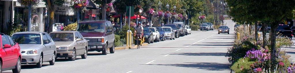
5 Ambleside West Vancouver is a car-dominated community, but it does have two urban villages that were shaped by transit. In 1912, when West Vancouver was incorporated, Ambleside and Dundarave were connected by the original Blue Bus line. They in turn fed the ferries at the foot of 14 th Street until Ambleside is a mini-west End: on both sides of Marine Drive there are four a half thousand apartments, the consequence of the Paterson Plan of Unlike Vancouver, West Van did not downzone its 50-acre highrise district. Today, all the usable sites have been taken.


6 Not a good sign An aging population, a growth rate of 0.5 percent and a distrust of new development make it difficult for West Vancouver to revitalize its commercial districts, leaving them vulnerable to an expanded Park Royal - Canada s first shopping mall. Ambleside struggles. On one hand, it has to handle loads of through traffic. On the other, it doesn t seem to attract people from the nearby parks and beaches, 60 percent of whom come from outside the municipality. Problem: too few pedestrian destinations and too many financial institutions. Like 41st Avenue in Kerrisdale, the village is a victim of the economic success of its customers. Marine Drive is the financial equivalent of Robson Street: banks all want a presence - and there s nothing quite like a blank façade to kill the retail vitality of a street. It opened in 1950, and now, a half century later, will launch The Village - a lifestyle centre meant to recreate the ambience of a main street without actually fitting into the community or accommodating independent retailers. No attempt appears to have been made to link the development with anything other than its own parking lot. Even trying to walk or cycle from across the street looks to be an unpleasant if not hostile experience.


7 Even low-rise development can be a tough sell in West Van. This design for a mixed-use project at Marine Drive and 17th Street by Paul Merrick Architects generated considerable controversy. (The sloping site suggested a fourth floor, which many opposed.) A special rezoning helped preserve much-needed medical offices while adding residential units on top.


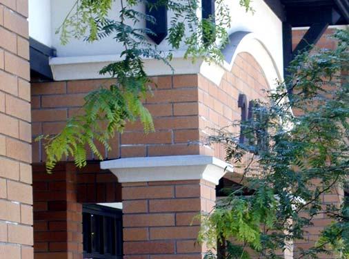
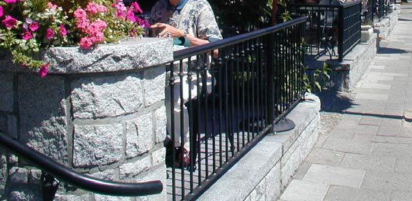
8 The best thing about Hollyburn Centre? According to the woman in the picture: the bench she is sitting on while waiting for the bus and the awning that gives her shade. The lights, litter barrels, transparent storefronts and landscaping add a sense of civility and security. Not to mention the art. The Hollyburn Centre deserves a PT Award for its quality, contextual response and good design.


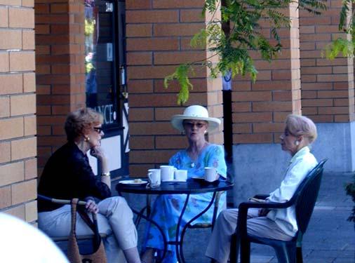
9 Sunday afternoon at Dundarave

10 Dundarave. The most beautiful neighbourhood village in Canada? Name one better.

11 Quiz: Find the Bike Route Lions Gate Bridge This is a slice of the Transportation Network map taken from West Vancouver s Official Community Plan. The only off-highway cycle route in the municipality is the Trans-Canada Trail, which in this case can be seen with a little maple leaf in the upper-left-hand corner. Note that neither it nor any other cycle route comes anywhere near the Lions Gate Bridge. One sentence in the plan says: Develop a comprehensive and accessible walking and cycling network. But a cyclist coming off the signed, signaled and connected bikeways to the south gets the impression that so far the municipality doesn t take this seriously. Why isn t there at least a signed route to connect Lions Gate with Ambleside that doesn t involve cycling on the sidewalk or against the traffic?

12 E:SPONSE Price Tags 35 - Fort Worth: the Vancouver of the South? Vancouver has nothing to fear from Fort Worth. Fort Worth's Sundance Square, to which you hear the Trinity project compared, is a patch of downtown restaurants and stores, centered around a full-block parking lot, and where the tallest building is a tornado-damaged glass skyscraper that's not worth anyone's effort to demolish. In fact, the tourist maps of Sundance Square show a blank space where the skyscraper is ("pay no attention...") but they do make a big deal out of the central surface parking. You might enjoy my review of Fort Worth, which is at content_ Jarrett Walker Pay no attention. Partner Nelson\Nygaard Consulting Associates


13 Price Tags is an electronic newsletter by Gordon Price. All West Vancouver pictures by Gordon. To subscribe, send an address to For archives of Price Tags, click here.
ACTIVE TRANSPORTATION
 Increasing ACTIVE TRANSPORTATION in Uxbridge Monday, September 21, 2015 Trudy Ledsham Suzanne Kershaw Surgeon General s Call to Action 50% of trips to Uxbridge High School are by car (DMG, TTS 2011) 2014
Non-Motorized Transportation 7-1
 Non-Motorized Transportation 7-1 Transportation facilities no longer mean just accommodating a vehicle powered by a combustion engine. Pedestrian and non-motorized facilities are important modes of travel
Community Improvement Plans: Creating walkable and liveable communities that support local business
 Community Improvement Plans: Creating walkable and liveable communities that support local business Kate Hall Program Manager ~ WALK Friendly Ontario Canada Walks, Green Communities Canada khall@greencommunitiescanada.org
PRICE TAGS. Progress
 PRICE TAGS Issue 33 June 16, 2004 Progress The North Shore is beginning to welcome cyclists and pedestrians from the Lions Gate Bridge. Before Proper signage, ramps and connecting routes have been built
Comments The Plan for Port Whitby
 Comments The Plan for Port Whitby April 24th, 2013 Community Meeting #2 Summary Report Prepared by GLPi April 29th, 2013 1 Introduction The purpose of the Port Whitby Secondary Plan Update, Community Improvement
Chapter 7. Transportation. Transportation Road Network Plan Transit Cyclists Pedestrians Multi-Use and Equestrian Trails
 Chapter 7 Transportation Transportation Road Network Plan Transit Cyclists Pedestrians Multi-Use and Equestrian Trails 7.1 TRANSPORTATION BACKGROUND The District of Maple Ridge faces a number of unique
Table #6 VISION CHARACTERISTICS
 Table #6 VISION White Flint is a place to live, work, play, shop, and walk with sufficient density to encourage quality redevelopment. Vibrant streets and consistent streetscapes are important. CHARACTERISTICS
RESOLUTION NO ?? A RESOLUTION OF THE CITY OF NEPTUNE BEACH ADOPTING A COMPLETE STREETS POLICY
 RESOLUTION NO. 2018-?? A RESOLUTION OF THE CITY OF NEPTUNE BEACH ADOPTING A COMPLETE STREETS POLICY WHEREAS, safe, convenient, and accessible transportation for all users is a priority of the City of Neptune
A CHANGING CITY. of Edmonton, it is essential that it reflects the long-term vision of the City.
 A CHANGING CITY By the year 2040, Edmonton will be home to more than 1 million people. To accommodate growth and support a healthy and compact city, we need a new approach to development/redevelopment
McLean Main Street Public Forum Follow-up
 McLean Main Street Public Forum Follow-up Sponsored & Hosted by John W. Foust, Dranesville District Supervisor McLean Planning Committee Fairfax County Office of Community Revitalization and Reinvestment
Creating walkable, bikeable and transit-supportive communities in Halton
 Creating walkable, bikeable and transit-supportive communities in Halton By presenting current research and best practices, the information in this paper is meant to support and broaden discussion on how
CONNECTING PEOPLE TO PLACES
 CONNECTING PEOPLE TO PLACES 82 EAST BENCH MASTER PLAN 07 Introduction The East Bench transportation system is a collection of slow moving, treelined residential streets and major arteries that are the
Mumford Terminal Replacement Opportunities Neighbourhood Open House. we are here. PHASE 2 Identifying and Evaluating Candidate Sites
 Welcome Replacement Opportunities Neighbourhood Open House. AGENDA PURPOSE 1. REVIEW the information boards 2. DISCUSS aspects of the project with the project team 3. SHARE your thoughts on replacement
Canada s Capital Region Delegation to the Velo-City Global 2010 Conference
 Canada s Capital Region Delegation to the Velo-City Global 2010 Conference Report of Findings from Visits, Meetings & Presentations In Amsterdam-Den Haag, Utrecht, Berlin & Copenhagen The Itinerary Copenhagen
Active Transportation Infrastructure Investment A Business Case
 Active Transportation Infrastructure Investment A Business Case In 2016, the Real Estate Foundation awarded the Capital Regional District a $50,000 grant for Shifting Gears: Land Use Change through Active
Speed Limits Study and Proposal. Public Input Session: 8/14/13
 Speed Limits Study and Proposal Public Input Session: 8/14/13 Why is Decatur a unique place for this project? First Community Transportation Plan in the nation with a Health Impact Assessment. Strong sense
City of Waterloo Complete Streets Policy
 City of Waterloo Complete Streets Policy Chris Hodgson P. Eng City of Waterloo Complete Streets Forum 2011 April 28-29 Toronto Waterloo context: Current population Major employers Universities and student
Peterborough Council on Aging
 Peterborough Council on Aging Discussion paper series #4, 2015 Transportation Transportation, including accessible and affordable public transport is a key factor influencing active aging. in particular,
162 RESIDENTS ATTENDED 2 DAYS OF WORKSHOPS 15 TABLE DISCUSSIONS WHAT WE HEARD. Oakridge Municipal Town Centre Workshops PLANNING PROGRAM
 OAKRIDGE MTC WORKSHOP 2017 CAMBIE CORRIDOR Phase 3 STEP 3: 3: October June 2017 CAMBIE CORRIDOR PLANNING PROGRAM 2 DAYS OF WORKSHOPS 15 TABLE DISCUSSIONS 162 RESIDENTS ATTENDED WHAT WE HEARD Oakridge Municipal
Incentive Zoning. Zoning Ordinance Advisory Committee June 21, Pam Thompson, Senior Planner, Sustainable Development and Construction
 Incentive Zoning Zoning Ordinance Advisory Committee June 21, 2018 Pam Thompson, Senior Planner, Sustainable Development and Construction Presentation Overview Stakeholder questions Updated charts Design
SPRINGFIELD REVITALIZATION REPORT
 SPRINGFIELD REVITALIZATION REPORT August 2015 Homewood Suites Springfield Town Center Promenade 2 SPRINGFIELD OVERVIEW This report covers recent development activity in the Springfield Commercial Revitalization
Chapter 2. Bellingham Bicycle Master Plan Chapter 2: Policies and Actions
 Chapter 2 Bellingham Bicycle Master Plan Chapter 2: Policies and Actions Chapter 2: Policies and Actions The Bicycle Master Plan provides a road map for making bicycling in Bellingham a viable transportation
EXECUTIVE SUMMARY: TRANSIT-ORIENTED DEVELOPMENT IN SMITHS FALLS, ONTARIO; A COMPARISON BETWEEN TWO SITES
 EECUTIVE SUMMARY: TRANSIT-ORIENTED DEVELOPMENT IN SMITHS FALLS, ONTARIO; A COMPARISON BETWEEN TWO SITES Topic and Purpose In 2007, the Mayor of Ottawa s Task Force on Transportation suggested adding a
MIXED USE AND STREETSCAPE INTEGRATION Avondale Will Basil Juliana Zannotto
 MIXED USE AND STREETSCAPE INTEGRATION Avondale Will Basil Juliana Zannotto Creating new development so that people will stop and see what Avondale has to offer The goal for my project was simple. I wanted
FEDERAL FISCAL YEAR 2020 TAP PUBLIC COMMENTS
 FEDERAL FISCAL YEAR 2020 TAP PUBLIC COMMENTS Ankeny High Trestle Trail Extension Yes 14 No 1 High Trestle Trail is our St. Louis Arch. Close that gap. Yes, extend it! The High Trestle Trail is already
Classification Criteria
 SCHEDULE D TO RECOMMENDED OFFICIAL PLAN AMENDMENT NO. 40 SCHEDULE C-4 Road Criteria Criteria Traffic Service Objective Land Service/Access Typical Daily Traffic Volume Flow characteristics Travel Speed
ECONOMY PEOPLE ENVIRONMENT
 Report Back on Local Transit Improvements May 29, 2013 ECONOMY PEOPLE ENVIRONMENT Intro Council Requested Report Back Topics Progress on Planning for Broadway Subway False Creek Bridges Local Transit Improvements
Section 8. Partnerships and Funding
 This section discusses the potential partnership and funding options that the Town should consider in order to assist with the implementation of the recommendations provided in the Plan. Section 8. Partnerships
National Report of Greece. The city of Kalamaria is the reference area for all street cases, and is therefore described only once, in this chapter.
 9. REFERENCE AREA The city of Kalamaria is the reference area for all street cases, and is therefore described only once, in this chapter. 9.1 Area and Data Description The city of Kalamaria covers an
Douglas Land Use and Transportation Strategy (DLUTS) Summary. August 2013
 Summary. August 2013") Douglas Land Use and Transportation Strategy (DLUTS) Summary August 2013 Background Douglas is a large and popular residential suburb of approximately 30,000 persons on the periphery of Cork City along
Douglas Land Use and Transportation Strategy (DLUTS) Summary August 2013 Background Douglas is a large and popular residential suburb of approximately 30,000 persons on the periphery of Cork City along
Tonight is for you. Learn everything you can. Share all your ideas.
 Strathcona Neighbourhood Renewal Draft Concept Design Tonight is for you. Learn everything you can. Share all your ideas. What is Neighbourhood Renewal? Creating a design with you for your neighbourhood.
WalkShop. Highland Creek Village
 On June 5, 2014, 15 people participated in a for the Transportation Master Plan. The purpose of the was to receive feedback from a diverse range of local stakeholders and document existing transportation
NATIONAL ACTION STRATEGY A VOICE FOR WALKING
 NATIONAL ACTION STRATEGY A VOICE FOR WALKING Canadians are coming together to create a unified voice for walking and to pick up the pace of action for walkable communities. Our goal: to restore everyday
Urban planners have invested a lot of energy in the idea of transit-oriented
 DOES TRANSIT-ORIENTED DEVELOPMENT NEED THE TRANSIT? D A N I E L G. C H AT M A N Urban planners have invested a lot of energy in the idea of transit-oriented developments (TODs). Developing dense housing
WELCOME. Purpose of the Open House. Update you on the project. Present a draft recommended plan. Receive your input
 WELCOME Purpose of the Open House The Town of Smiths Falls has initiated the Beckwith Street Redevelopment Plan that includes the preparation of a streetscape functional design for the renewal of Beckwith
Planning Regionally With Transit
 Planning Regionally With Transit Nathan Coats Director of Operations CTAA Expo 2015 Tampa Began 1992. Serves eastern Cache County to Preston, ID. Population- 115,000 34 bus fleet, 26 fixed route buses;
Thesis Presentation. Moorhead City Walk: A Master Plan to Reimage Moorhead, Minnesota s Urban Core. Brad Garcia Advisors: Jason Kost & Dominic Fischer
 Thesis Presentation Moorhead City Walk: A Master Plan to Reimage Moorhead, Minnesota s Urban Core Brad Garcia Advisors: Jason Kost & Dominic Fischer MOORHEAD, MN Red River Center Ave 8 TH St N FARGO, ND
A Bicycle Network for a North American Metropolis: The Case of Montreal
 A Bicycle Network for a North American Metropolis: The Case of Montreal Marc Jolicoeur, Research Coordinator, Vélo Québec 1251 Rue Rachel Est, Montreal H2 J2J9, Canada marc-jolicoeur@velo.qb.ca Summary
APPENDIX 4 PEDESTRIAN FACILITY DESIGN INFORMATION
 APPENDIX 4 PEDESTRIAN FACILITY DESIGN INFORMATION 96 EXHIBIT 1 97 EXHIBIT 2 Guidelines for Installing Sidewalks Source: Design and Safety of Pedestrian Facilities, Institute of Transportation Engineers,
DATE: June 22, General Release SUBMITTED BY: LAND DEVELOPMENT SERVICES. RE: City Centre Survey Results
 DATE: June 22, 2018 TO: General Release SUBMITTED BY: LAND DEVELOPMENT SERVICES RE: City Centre Survey Results The following is a summary of preliminary findings for the Community Identity and Vision survey.
Illustrated Principles of Good Planning
 Illustrated Principles of Good Planning The Miami 21 Zoning Code incorporates time-tested planning principles into the zoning regulations of our City. These are principles that make for better neighborhoods,
Bicycle 360 Study Tour
 WE INSPIRE AND ENCOURAGE EXCHANGE SO YOU CAN INNOVATE Bicycle 360 Study Tour A tour mixing together ingredients from the Dutch cycling tradition! This tour is also a training session to help city planners,
Encouragement. Chapter 4. Education Encouragement Enforcement Engineering & Facilities Evaluation & Planning. Encouragement Chapter 4
 Encouragement Education Encouragement Enforcement Engineering & Facilities Evaluation & Planning Photo above: Children show off their ribbons at the Tour de Virginia Beach. Virginia Beach Bikeways and
TOWN OF PORTLAND, CONNECTICUT COMPLETE STREETS POLICY
 TOWN OF PORTLAND, CONNECTICUT COMPLETE STREETS POLICY I. VISION, GOALS & PRINCIPLES VISION To improve the streets of Portland making them safer and more accessible for all users including pedestrians,
Solana Beach Comprehensive Active Transportation Strategy (CATS)
") Solana Beach Comprehensive Active Transportation Strategy (CATS) 3.0 Goals & Policies The Solana Beach CATS goals and objectives outlined below were largely drawn from the Solana Beach Circulation Element
Solana Beach Comprehensive Active Transportation Strategy (CATS) 3.0 Goals & Policies The Solana Beach CATS goals and objectives outlined below were largely drawn from the Solana Beach Circulation Element
CITY OF ALPHARETTA DOWNTOWN MASTER PLAN TRAFFIC EVALUATION
 CITY OF ALPHARETTA DOWNTOWN MASTER PLAN TRAFFIC EVALUATION June 2015 CITY OF ALPHARETTA DOWNTOWN MASTER PLAN TRAFFIC EVALUATION Introduction The Alpharetta Downtown Master Plan was developed in the fall
The Impact of Placemaking Attributes on Home Prices in the Midwest United States
 The Impact of Placemaking Attributes on Home Prices in the Midwest United States 2 0 1 3 C O N S T R U C T E D E N V I R O N M E N T C O N F E R E N C E M A R Y B E T H G R A E B E R T M I C H I G A N
Bicycle Master Plan Goals, Strategies, and Policies
 Bicycle Master Plan Goals, Strategies, and Policies Mobilizing 5 This chapter outlines the overarching goals, action statements, and action items Long Beach will take in order to achieve its vision of
CHAPTER 1 INTRODUCTION
 CHAPTER 1 INTRODUCTION Chapter Table of Contents THE 2017 HOUSTON BIKE PLAN 1-1 HOUSTON BIKEWAYS PROGRAM 1-2 HISTORY OF BICYCLE PLANNING IN HOUSTON 1-3 BICYCLE LEVEL OF COMFORT 1-3 EXISTING PLANS, PROGRAMS
Montco 2040 Implementation Grant Program Award Summary
 Municipality Montco 2040 Implementation Grant Program - 2017 Award Summary Support Downtowns Walk/Bike Montco Name of Project Business Parks Total Project Cost Grant Award Schwenksville Main Street Pedestrian
MEETING NOTES. 26 Street Station Committee. October 22, Westgate Community Hall
 MEETING NOTES 26 Street Station Committee Westgate Community Hall Attendance 26 Street Station Committee There were 11 representatives from the following communities and stakeholder groups: Killarney Sunalta
Pattullo Bridge Replacement Project Community Connections Phase 2 Consultation. Appendix 3: Open House Display Boards
 Replacement Project Community Connections Phase 2 Consultation Appendix 3: Open House Display Boards November 2016 Welcome! Welcome to the Replacement Project Public Open House We Want to Hear from You
5/7/2013 VIA . RE: University Village Safeway Expansion (P13-019)
") 5/7/2013 VIA EMAIL David Hung, Associate Planner Community Development Department, Current Planning Division City of Sacramento 300 Richards Boulevard, 3 rd Floor Sacramento, CA 95811 RE: University Village
5/7/2013 VIA EMAIL David Hung, Associate Planner Community Development Department, Current Planning Division City of Sacramento 300 Richards Boulevard, 3 rd Floor Sacramento, CA 95811 RE: University Village
This objective implies that all population groups should find walking appealing, and that it is made easier for them to walk more on a daily basis.
 Walking for life The Norwegian Walking Strategy Guro Berge Norwegian public Roads Administration "Walking for life" is the slogan for the National Walking Strategy that is now being formulated in Norway.
Chapter 14 PARLIER RELATIONSHIP TO CITY PLANS AND POLICIES. Recommendations to Improve Pedestrian Safety in the City of Parlier (2014)
") Chapter 14 PARLIER This chapter describes the current status and future plans for biking and walking in the City of Parlier. RELATIONSHIP TO CITY PLANS AND POLICIES The Parlier General Plan is the primary
Chapter 14 PARLIER This chapter describes the current status and future plans for biking and walking in the City of Parlier. RELATIONSHIP TO CITY PLANS AND POLICIES The Parlier General Plan is the primary
7/23/2017 VIA . Michael Hanebutt City of Sacramento Community Development Department 300 Richards Boulevard, 3 rd Floor Sacramento, CA 95811
 7/23/2017 VIA EMAIL Michael Hanebutt City of Sacramento Community Development Department 300 Richards Boulevard, 3 rd Floor Sacramento, CA 95811 RE: 65 th Street Apartments (DR17-220) Dear Mr. Hanebutt:
Building a Liveable Ottawa 2031 Backgrounder 4: Kanata/Stittsville
 Building a Liveable Ottawa 2031 Backgrounder 4: Kanata/Stittsville Wards 4, 6 and 23 Official Plan Transportation Master Plan Cycling Plan Pedestrian Plan October 2013 ottawa.ca/liveableottawa Building
CITY OF COCOA BEACH 2025 COMPREHENSIVE PLAN. Section VIII Mobility Element Goals, Objectives, and Policies
 CITY OF COCOA BEACH 2025 COMPREHENSIVE PLAN Section VIII Mobility Element Goals, Objectives, and Policies Adopted August 6, 2015 by Ordinance No. 1591 VIII MOBILITY ELEMENT Table of Contents Page Number
Transforming the. Michigan Avenue Corridor. a complete streets and transit-oriented development study Michigan State University Student Research Team
 Transforming the Michigan Avenue Corridor a complete streets and transit-oriented development study Michigan State University Student Research Team Dominic Adams Annie Fardell Jon Roberts Jeff Stivenson
TRANSPORTATION NEEDS ASSESSMENT
 TRANSPORTATION NEEDS ASSESSMENT A travel demand analysis was carried out to determine the operational issues and the potential benefit that adding traffic capacity would have on the road network. All the
good walking is good business making massachusetts more walkable
 good walking is good business making massachusetts more walkable Nothing draws a crowd like a crowd. P.T. Barnum 15 minutes with WalkBoston who we are / what we do why walkability makes economic sense
APPENDIX 1 QUESTIONNAIRE RESULTS
 APPENDIX 1 QUESTIONNAIRE RESULTS NORTHERN BERKS REGION PLANNING QUESTIONNAIRE 1. From 1990 to 2000, the population of the Northern Berks Region grew from 11,810 to 13,372, a 13.2% increase. In the future,
Introduction. Using the Checklist. TDM-Supportive Development Design and Infrastructure Checklist Version 1.0 (30 June 2017) City of Ottawa
 City of Ottawa") Introduction The s Transportation Impact Assessment (TIA) Guidelines (specifically Module 4.1 Development Design) requires proponents of qualifying developments to use the City s TDM-Supportive Development
Introduction The s Transportation Impact Assessment (TIA) Guidelines (specifically Module 4.1 Development Design) requires proponents of qualifying developments to use the City s TDM-Supportive Development
FAQ s Walsh Road / Ferguson Road Pilot Scheme
 FAQ s Walsh Road / Ferguson Road Pilot Scheme What is happening? Traffic calming measures are being installed as a pilot. Temporary Bollards will be installed to the east of 1 Ferguson Road and a Temporary
NM-POLICY 1: Improve service levels, participation, and options for non-motorized transportation modes throughout the County.
 Transportation PRINCE WILLIAM COUNTY 2008 COMPREHENSIVE PLAN NON-MOTORIZED PLAN CONTENTS Goals, Policies, and Action Strategies Table 4 (Bike Facility Classifications and Descriptions) Table 5 (Bike Facility
ATTACHMENT 4 - TDM Checklist. TDM Checklist Overview
 ATTACHMENT 4 - TDM Checklist TDM Checklist Overview The proposed checklist rates developments on the degree to which they are TDM and transit supportive. Points are assigned based on the level of transit
PASSENGER RAIL STATION LOCATION AND DESIGN WORKING GROUP MEETING STOCKBRIDGE
 PASSENGER RAIL STATION LOCATION AND DESIGN WORKING GROUP MEETING STOCKBRIDGE Criteria for Passenger Rail Station Location Municipal Level To objectively compare Target Areas in all communities along the
3. INTERCONNECTED STREETS AND TRANSPORTATION NETWORKS
 Design Approaches 61 3. INTERCONNECTED STREETS AND TRANSPORTATION NETWORKS There are a number of different approaches to interconnect streets in neighborhoods and Development Areas. Interconnections provide
5 CIRCULATION AND STREET DESIGN
 5 CIRCULATION AND STREET DESIGN This chapter describes circulation and streetscape improvements proposed for the Northwest Chico Specific Plan Area. It includes detailed design specifications for existing
ACTIVE TRANSPORTATION Active Community Checklist
 ACTIVE TRANSPORTATION Active Community Checklist Safe, accessible spaces to walk, hike, bike and play is an important part of building strong, healthy and active communities for residents and visitors.
Nanaimo Transportation Master Plan. Phase 1 Consultation Summary
 Nanaimo Transportation Master Plan Phase 1 Consultation Summary Transportation Advisory Committee Meeting Wednesday December 12, 2012 Agenda Study Update Phase 1 Consultation Process Phase 1 Consultation
What is the status of the CPR Yards Crossing Study?
 September 2015 Project Advisory Committee (PAC) Sectors RESIDENTS Centennial Community Improvement Association Dufferin Residents Association of Winnipeg William Whyte Residents Association LOCAL BUSINESS
Have your say on the transformation of Oxford Street West
 Have your say on the transformation of Oxford Street West About Living Streets We are Living Streets, the UK charity for everyday walking. We want to create a walking nation, free from congested roads
Building a Liveable Ottawa 2031 Backgrounder 5: Barrhaven/Riverside South/Leitrim
 Building a Liveable Ottawa 2031 Backgrounder 5: Barrhaven/Riverside South/Leitrim Wards 3 and 22 Official Plan Transportation Master Plan Cycling Plan Pedestrian Plan October 2013 ottawa.ca/liveableottawa
8. Collisions INTRODUCTION
 8. Collisions INTRODUCTION While traffic collisions can affect anyone, they have a disproportionate impact on bicyclists, who along with pedestrians are the most vulnerable users of the transportation
REDEVELOPMENT OPPORTUNITY! FOR SALE
 SALE PRICE: Contact Agent LOT SIZE: 0.31 Acres BUILDING SIZE: 2,830 SF YEAR BUILT: 1906 ZONING: CBD Central Business District CROSS STREETS: 2nd Street South PROPERTY OVERVIEW This offering is for the
WALK- AND bike-friendly TURLOCK
 WALK- AND bike-friendly TURLOCK Ideas to Encourage Walking and Biking Benefits to the COMMUNITY Get Connected People who walk and bike have many more opportunities for casual interactions with friends
Corpus Christi Metropolitan Transportation Plan Fiscal Year Introduction:
 Introduction: The Safe, Accountable, Flexible, Efficient Transportation Equity Act: A Legacy for Users (SAFETEA-LU) has continued the efforts started through the Intermodal Surface Transportation Efficiency
WELCOME! TOWN CENTRE PARK INFORMATION SESSION WHAT IS HAPPENING? GOALS FOR TODAY. TOWN STAY CONNECTED WITH US! #1 INFORM WE ARE HERE
 1 WELCOME! Thank you for coming to the Information Session! Please provide us with your comments and ideas. We will use your input to inform the visioning process and creation of the framework for the
Shifting Gears for a Healthier City.
 Shifting Gears for a Healthier City. Mississauga s Cycling Master Plan is an ambitious strategy that sets out to transform Mississauga into a city that is conducive to cycling for daily transportation
CYCLING PLAN UPDATE. DIY Workshop FACILITATOR GUIDE
 DIY Workshop FACILITATOR GUIDE CYCLING PLAN UPDATE Prepared as part of the Public and Statekholder Engagement Program for the City of Burlington Cycling Plan Update February 2018 About this Facilitator
Wyldewood Estates. Pre-Application Public Engagement Summary of Issues and Responses
 Wyldewood Estates Pre-Application Public Engagement Summary of Issues and Responses March 2016 Executive Summary Morguard Residential Properties has been thoughtfully planning the redevelopment of Wyldewood
PEDESTRIAN ACTION PLAN
 ATTACHMENT 2 CITY OF SANTA MONICA PEDESTRIAN ACTION PLAN CITY OF SANTA MONICA PEDESTRIAN ACTION PLAN This page intentionally left blank EXECUTIVE SUMMARY CHAPTER 1 EXECUTIVE SUMMARY Setting the Stage
Coolest Cities Results Summary
 Coolest Cities Results Summary About Coolest Cities Canada s six largest urban areas provide homes and jobs for almost 15 million people, nearly half of our population. Transporting these citizens to and
CITY OF SAINT JOHN TRAFFIC CALMING POLICY
 CITY OF SAINT JOHN TRAFFIC CALMING POLICY VERSION: 1.0 April 10, 2012 Pedestrians, Cyclists and Motorists Sharing Street Spaces CONTENTS INTRODUCTION... 3 POLICY GOAL... 3 POLICY OBJECTIVES... 3 GUIDING
-Current Get On Board initiative: Existing LTC program to help make LTC accessible, informative, and encourage use of public transit
 2.1.1 Encourage community partners to engage London Transit Commission through the Get On Board program to educate Londoners on how to use the bus system (current initiative)(year 1 to 3) -Current Get
Viaducts, Eastern Core and False Creek Flats Cycling Improvements HUB Vancouver/UBC committee 2013/05/13
 Viaducts, Eastern Core and False Creek Flats Cycling Improvements HUB Vancouver/UBC committee 2013/05/13 Table of Contents Executive Summary Cycling in the Viaducts Area: Current Situation and the City
Building a Toronto that Moves
 Building a Toronto that Moves Image courtesy of the City of Toronto Setting Election Priorities for Walking, Cycling & Public Transit Toronto is a fast-paced, dynamic city. It s a city that moves except
WELCOME! To the Centennial Neighbourhoods Secondary Plan and Transportation Management Plan Information Centre. City of Hamilton
 WELCOME! To the Centennial Neighbourhoods Secondary Plan and Transportation Management Plan Information Centre City of Hamilton Public Information Centre #2 Dec 1, 2015 CENTENNIAL NEIGHBOURHOODS SECONDARY
Recipient of NCTCOG 2009 Sustainable Call for Projects. Public Meeting January 28, 2016
 Recipient of NCTCOG 2009 Sustainable Call for Projects Public Meeting January 28, 2016 Council Target Neighborhood 2004 2005-07: 8 meetings Strategy NLZ3: NEW GT CODE Casa View Heights Plan adopted by
Anniedale- Tynehead NCP Best Practices in Transportation Planning Summary
 Anniedale- Tynehead NCP Best Practices in Transportation Planning Summary The City of Surrey Anniedale-Tynehead NCP Best Practices Transportation Summary This document provides a summary of the Bunt &
Obey Creek PEDESTRIAN CIRCULATION EAST WEST PARTNERS PEDESTRIAN CIRCULATION CREEK SIDE LANE SLIP STREET SCOTT MURRAY MAIN STREETS EAST/WEST
 THE VILLAGE AT PEDESTRIAN CIRCULATION MAIN STREETS NORTH/SOUTH MAIN STREETS EAST/WEST SLIP STREET CREEK SIDE LANE PEDESTRIAN CIRCULATION DESCRIPTION: Circulation through the downtown of is organized by
2.0 Ballpark District
 2.0 Ballpark District 2.1 Introduction The Ballpark District is located in the south central portion of the City of Lake Elsinore, just north of the City limit line in this area. The Ballpark District
Arapahoe Square Zoning + Design Standards & Guidelines Task Force Meeting 9 January 27, 2016
 Arapahoe Square Zoning + Design Standards & Guidelines Task Force Meeting 9 January 27, 2016 Agenda 3:00 Opening/Welcome 3:15 Touch Base on Schedule and Milestones Moving Forward 3:20 Review the Overall
PRICE TAGS. Issue 63. April 4, Villages
 PRICE TAGS Issue 63 April 4, 2005 Villages Reinventing the Streetcar Village In Price Tags 60, you can find a story on the streetcar villages built along transit corridors in the early 20 th century. But
2.0 Existing Conditions
 20 2.0 Existing Conditions 2.1 Land Use, Future Growth Patterns, Physical Barriers Geographic Overview Sutter County s land use pattern is characterized by extensive agricultural areas, significant natural
21.07 TRANSPORT CONNECTIVITY AND INFRASTRUCTURE
 21.07 TRANSPORT CONNECTIVITY AND INFRASTRUCTURE 21.07-1 Connectivity and Choice Transport connectivity and mode choice are critical to achieving productive, sustainable and socially just cities. Travel
14: 2197 Lakeshore Rd West, Bronte Athletic Field
 1. Description of Property 14: 2197 Lakeshore Rd West, Bronte Athletic Field Municipal Address 2197 Lakeshore Rd. West ame (if applicable) Bronte Athletic Field Legal Description CO 4 SDS PT LOT 27 Location
Niagara Cycling Tourism. Presented by: Susan Morin Prepared by Karine Whittingham May 5th, 2014
 Niagara Cycling Tourism Presented by: Susan Morin Prepared by Karine Whittingham May 5th, 2014 Agenda! Why Cycling Tourism! Economic Impact! Objective & Activities! Stakeholders! Product Development! Bicycle
El Paso County 2040 Major Transportation Corridors Plan
 El Paso County 2040 Major Transportation Corridors Plan Connect-our-County Online Transportation User Survey Preliminary Results June 24, 2010 Years of Residence 2. How many years have you LIVED HERE?