DRAFT. Corridor study. Honeysuckle Road. October Prepared for the City of Dothan, AL. Prepared by Gresham, Smith and Partners
|
|
|
- Rafe Walsh
- 5 years ago
- Views:
Transcription


1 DRAFT Corridor study Honeysuckle Road October 2017 Prepared for the City of Dothan, AL Prepared by
2 TABLE OF CONTENTS SECTION I... 1 STUDY SUMMARY... 1 INTRODUCTION... 1 CONCLUSIONS... 5 SECTION II... 7 EXISTING CONDITIONS... 7 ADJACENT LAND USE... 7 EXISTING TRANSPORTATION FACILITIES... 7 EXISTING TRAFFIC VOLUMES... 8 EXISTING INTERSECTION LEVELS OF SERVICE PEDESTRIAN AND BICYCLE FACILITIES CRASH HISTORY PARKING PLANNED TRANSPORTATION IMPROVEMENTS SECTION III CORRIDOR STUDY METHODOLOGY YEAR 2022, YEAR 2027 AND YEAR 2037 PROJECTED TRAFFIC VOLUMES HONEYSUCKLE ROAD RECOMMENDATIONS HONEYSUCKLE ROAD TYPICAL SECTION CONCEPTS FUTURE EXTENSION OF HONEYSUCKLE ROAD YEAR 2022, 2027 AND 2037 INTERSECTION LEVELS OF SERVICE S. PARK AVENUE/HONEYSUCKLE ROAD/HATTON ROAD IMPROVEMENTS. 34 EVALUATION OF ADDITIONAL IMPROVEMENTS IMPROVEMENT COST ESTIMATES PUBLIC INVOLVEMENT MEETING SUMMARY CONCLUSIONS LIST OF APPENDICES APPENDIX A APPENDIX B APPENDIX C APPENDIX D APPENDIX E APPENDIX F APPENDIX G Traffic Count Worksheets & Crash Diagrams Intersection Levels of Service Worksheets Honeysuckle Road Roadway Concepts Potential Extension of Honeysuckle Road Concept S. Park Avenue/Honeysuckle Road/Hatton Road Improvement Options Detailed Concept Cost Estimates Public Involvement Meeting Comment and Attendee Sign-In Sheets
3 LIST OF TABLES Table 1. Existing Daily Traffic Volumes... 8 Table 2. Year 2017 Existing Intersection Levels of Service Table 3. Crash History by Crash Type Table 4. Historical AADT Volumes and Growth Rate Table 5. Year 2037 Daily LOS and Recommended Number of Lanes Table 6. Year 2022 Intersection Levels of Service Table 7. Year 2027 Intersection Levels of Service Table 8. Year 2037 Intersection Levels of Service Table 9. S. Park Avenue/Honeysuckle Road Improvements Intersection Levels of Service Table 10. Campbellton Highway/Taylor Road Improvements Intersection Levels of Service Table 11. S. Park Avenue/Taylor Road Improvements Intersection Levels of Service Table 12. S. Oates Street/Southgate Road Improvements Intersection Levels of Service Table 13. Summary of Concept Cost Estimates Table 14. Summary of Public Involvement Meeting Comment Forms LIST OF FIGURES Figure 1. Corridor Location and Vicinity... 2 Figure 2. Study Area Intersections... 4 Figure 3. Existing Lane Configurations and Traffic Control... 9 Figure 4. Year 2017 Existing AM and PM Peak Hour Traffic Volumes Figure 5. Honeysuckle Road Curve Existing Superelevation & Radius Figure 6. Year 2022 AM and PM Peak Hour Traffic Volumes Figure 7. Year 2027 AM and PM Peak Hour Traffic Volumes Figure 8. Year 2037 AM and PM Peak Hour Traffic Volumes Figure 9. Daily Traffic Volumes Figure 10. Roadway Segment LOS with Existing Roadway Geometry Figure 11. Roadway Segment LOS with Recommended Roadway Geometry Figure 12. Concept A Typical Sections Figure 13. Concept B Typical Sections Figure 14. Concept C Typical Sections Figure 15. Concept D Typical Sections Figure 16. Honeysuckle Road Extension Concept Figure 17. Honeysuckle Road Extension at Taylor Road/Campbellton Highway Roundabout Concept Figure 18. S. Honeysuckle Road Realigned Concept Figure 19. S. Park Avenue/Honeysuckle Road/Hatton Road Roundabout Concept Figure 20. S. Park Avenue/ Taylor Road Roundabout Concept Figure 21. S. Oates Street/Southgate Road RCUT Concept Figure 22. S. Oates Street/Southgate Road Directional Median Concept Figure 23. Home or Business Location of Attendees... 46
4 SECTION I STUDY SUMMARY INTRODUCTION (GS&P) performed a corridor study to assess potential improvements along the Honeysuckle Road corridor between W. Main Street and S. Park Avenue in Dothan, Alabama. The study addresses existing operational and safety deficiencies along the Honeysuckle Road corridor and well as the impact of future traffic growth along the corridor. The improvement options include roadway widening, sidewalk improvements, bicycle lanes and/or multi-use trails. Additional improvements evaluated include the extension of Honeysuckle Road from S. Park Avenue to Campbellton Highway. Figure 1 shows the general study area for the Honeysuckle Road Corridor Study. In addition to the traffic impact analysis, GS&P has also undertaken additional traffic analysis as requested by the City of Dothan. The additional traffic analysis includes the following: Operational and safety improvements to S. Park Avenue between Hatton Drive and Moore Road. Roundabout analysis at the Honeysuckle Road/Hatton Road/S. Park Avenue intersection, the S. Park Avenue/Taylor Road intersection, and the Campbellton Highway/Taylor Road intersection. Evaluation of the existing unsignalized median opening at the S. Oates Street/Southgate Road intersection. This study has been prepared in accordance with the following standards and includes the following data sources: Traffic Access and Impact Studies for Site Development, Institute of Transportation Engineers Trip Generation, 9 th Edition, Institute of Transportation Engineers Trip Generation Handbook, 2001 Edition, Institute of Transportation Engineers Manual on Uniform Traffic Control Devices (MUTCD), 2009 Edition Highway Capacity Manual 2010, Transportation Research Board A Policy on Geometric Design of Highways and Streets, 6th Edition, 2011, American Association of State Highway and Transportation Officials 2012 Generalized Service Volumes Tables, Florida Department of Transportation 1


5 Figure 1. Corridor Location and Vicinity 2
6 Scope of Corridor Study The scope of the corridor study is as follows: 1. Collect existing traffic, crash and roadway data along Honeysuckle Road and at other key study intersections. 2. Evaluate existing daily and AM and PM peak hour traffic operations. 3. Evaluate crash data at three (3) key locations. 4. Develop five year (2022), ten year (2027) and twenty year (2037) daily and AM and PM peak hour traffic forecasts. These forecasts include future growth (based on historical trends and approved but unbuilt development) and adjustments for the future cul-de-sac of Moore Road. 5. Based on the future daily traffic forecasts for the design year (2037) determine recommended roadway lane requirements along Honeysuckle Road. 6. Develop roadway concepts that accommodate bicycle and pedestrians along the Honeysuckle Road corridor. 7. Develop a roadway concept that extends Honeysuckle Road to Campellton Highway at the Taylor Road intersection. 8. Future five year (2022), ten year (2027) and twenty year (2037) intersection levels of service. 9. Develop intersection improvement options at the S. Park Avenue/Honeysuckle Road and S. Park Avenue/Hatton Road intersections. 10. Evaluate intersection improvement options at study area intersections. 11. Develop cost estimates for the roadway concepts and intersection improvement options. The following sections of Honeysuckle Road were evaluated as part of this corridor study: W. Main Street (US Highway 84) to Fortner Street Fortner Street to SR 52 (Hartford Highway) SR 52 (Hartford Highway) to S. Park Avenue Based on input from City of Dothan staff, the following intersections were analyzed as part of this study: 1. S. Oates Street/Southgate Road 2. Campbellton Highway/Taylor Road 3. Moore Road/Taylor Road 4. S. Park Avenue/Taylor Road 5. S. Park Avenue/Moore Road 6. S. Park Avenue/Honeysuckle Road 7. S. Park Avenue/Hatton Road 8. Honeysuckle Road/SR Honeysuckle Road/Fortner Street 10. Honeysuckle Road/W. Main Street 3

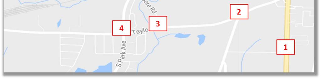
7 Figure 2. Study Area Intersections 4
8 CONCLUSIONS The following are the findings and recommendations from the Honeysuckle Road corridor study: Findings The following is a summary of the improvement options along Honeysuckle Road evaluated in this study: Concept A Widening with Trail Concept Concept B Widening with Bike Lanes and Sidewalks Concept Concept C Widening with No Sidewalks/Trails or Bike Lanes Concept D Widening with No Trails or Bike Lanes with Sidewalk on One Side (from W. Main Street to SR 52) Other improvements that were evaluated and preliminary cost estimates developed for include: Honeysuckle Road Extension S. Park Avenue to Campellton Highway (for future planning) Realigned Honeysuckle Road Homestead Road to S. Park Avenue Roundabout at Honeysuckle Road/Hatton Road/S. Park Avenue Roundabout at S. Park Avenue/Taylor Road Restricted Crossing U-turn (RCUT) at S. Oates Street at Southgate Road Directional Median with Acceleration Lane at S. Oates Street at Southgate Road Superelevation Correction on Honeysuckle Road just south of Homestead Road Other locations that were evaluated for improvements include: Campbellton Highway/Taylor Road intersection Recommendations Based on the Honeysuckle Road corridor study documented in this report, the following are recommended to mitigate existing operational and safety issues and accommodate future projected traffic over the next 20 years along Honeysuckle Road: Between W. Main Street and Fortner Street, a four (4) lane divided typical section should be provided. 11-foot travel lanes along with a 15-foot raised median or a 15- foot two-way left turn lane are recommended. Left turn lanes should be provided at key intersections. Between Fortner Street and SR 52, a three (3) lane undivided typical section is recommended. It is recommended that the center lane be reconfigured as a center twoway left turn lane to accommodate left turns to the existing and future development along the west side of the roadway. 11-foot travel lanes along with a 15-foot center 5
9 two-way left turn lane are recommended. Alternately, the existing condition of two southbound through lanes and one northbound through lane could be maintained, until such a time as development on the west side of Honeysuckle Road requires reevaluation. Between SR 52 and S. Park Avenue, a two (2) lane undivided typical section is recommended. 11-foot travel lanes are recommended. Improvements to the S. Park Avenue/Honeysuckle Road and S. Park Avenue/Hatton Road intersections are recommended. Two (2) options the City of Dothan should consider are: o A roundabout combining Honeysuckle Road, Hatton Road and S. Park Avenue into one intersection o Relocate Honeysuckle Road so it intersects with S. Park Avenue north of the existing Hatton Road. Hatton Road would remain open only to local traffic at S. Park Avenue. Through traffic on Hatton Road would need to utilize relocated Honeysuckle Road. Recommendations were also developed for other area roadways and intersections based on additional analysis undertaken. These include: Single lane roundabout will provide adequate LOS at the Taylor Road/Campbellton Highway intersection. The addition of the future Honeysuckle Road Extension as the fourth leg can be accommodated from both a geometry and traffic perspective. To improve safety, the City of Dothan should consider modifying the median opening at the S. Oates Street/Southgate Road intersection and converting the intersection to a restricted crossing U-turn (RCUT) intersection. Correct the superelevation and provide paved & unpaved shoulders for the horizontal curve on Honeysuckle Road just south of Homestead Road. While this improvement will provide a safety benefit, it does not provide any capacity or LOS improvement along this section of Honeysuckle Road. Based on the preliminary analysis, a traditional signal is projected to operate better than a single lane roundabout at the S. Park Avenue/Taylor Road intersection. It is recommended that this intersection be monitored on a regular basis to determine when a signal would be warranted at this location. 6
10 SECTION II EXISTING CONDITIONS ADJACENT LAND USE There are numerous land uses along Honeysuckle Road. Between W. Main Street and Fortner Street, the land uses are primarily commercial businesses with some residential closer to Fortner Street. Between Fortner Street and SR 52, it is a mix of residential, commercial businesses and Honeysuckle Middle School. South of SR 52, it is primarily residential or vacant land with some commercial at the intersections of SR 52 and S. Park Avenue. There are also several churches along the corridor. EXISTING TRANSPORTATION FACILITIES The following provides a description of the existing street system in the study area including a description of street classifications and characteristics. Refer to Figure 1 for the location of the following roadways. Honeysuckle Road: Honeysuckle Road is a two/three lane minor arterial roadway running primarily north-south with a posted speed limit of 35 mph between W. Main Street and SR 52/Hartford Highway and a posted speed limit of 40 mph from SR 52 (Hartford Highway) and S. Park Ave. Campbellton Highway: Campbellton Highway is a two-lane minor arterial roadway running primarily north-south with a posted speed limit of 40 mph. Taylor Road: Taylor Road is a two-lane major collector east-west roadway with a posted speed limit of 40 mph. S. Oates Street: S. Oates Street is a four-lane divided north-south principal arterial roadway with a 55 mph speed limit. Southgate Road: Southgate Road is a two-lane local east-west roadway with a posted speed limit of 30 mph. S. Park Avenue: S. Park Avenue is a two lane north-south minor arterial roadway in the vicinity of the Honeysuckle Road with a 40 mph speed limit. Figure 3 schematically depicts the existing lane configurations and traffic control at the study area intersections. 7
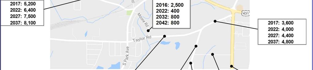
11 EXISTING TRAFFIC VOLUMES Existing AM and PM peak hour turning movement counts at the study area intersections were collected from a previous traffic study for Oates Park (counts conducted in 2013) and also by NDS Data Services in November, Year 2017 AM and PM peak hour volumes were estimated based on a 1.7 percent growth rate for traffic on S. Oates Street and one percent growth rate for local traffic. The Year 2017 AM and PM peak hour volumes are shown in Figure 4. The raw traffic count worksheets are provided in Appendix A. The turning movement counts at following locations were conducted in 2013: Campbellton Highway at Taylor Road Taylor Road at Moore Road Taylor Road at Park Avenue Park Avenue at Moore Road Honeysuckle Road at Park Avenue Park Avenue at Hatton Road The turning movement counts at following locations were conducted in 2016: S. Oates Street at Southgate Road Honeysuckle Road at SR 52 Honeysuckle Road at Fortner Street Honeysuckle Road at Main Street (US 84) Daily traffic counts were also collected by NDS Data Services along Honeysuckle Road in November, Existing daily traffic volumes along are shown in Table 1. These counts are also provided in Appendix A. Table 1. Existing Daily Traffic Volumes Roadway and Section Daily Traffic Honeysuckle Road W. Main Street to Fortner Street 14,600 Honeysuckle Road Fortner Street to SR 52 10,200 Honeysuckle Road SR 52 to S. Park Avenue 5,200 8

12 Figure 3. Existing Lane Configurations and Traffic Control 9
13 Figure 4. Year 2017 Existing AM and PM Peak Hour Traffic Volumes 10
14 EXISTING INTERSECTION LEVELS OF SERVICE Based on the existing lane configurations and traffic control presented in Figure 3, and the existing traffic volumes presented in Figure 4, peak hour traffic operations were analyzed at the study area intersections using the methodologies outlined in the 2010 Highway Capacity Manual (HCM) and using the Synchro 9.1 software program. According to the HCM, there are six levels of service (LOS) by which the operational performance of an intersection may be described. These levels of service range between LOS "A" which indicates a relatively free-flowing condition and LOS "F" which indicates operational breakdown. The results of the intersection levels of service analysis for the existing conditions are summarized in Table 2. As shown in Table 2, all study area intersections operate at LOS D or better in the AM and PM peak hours with the exception of the Honeysuckle Road/W. Main Street intersection which operates at LOS E in the AM and PM peak hours, the eastbound approach to the S. Oates Street/Southgate Road intersection, which operates at LOS F during the AM and PM peak hours and the southbound approach to the S. Park Avenue/Taylor Road intersection which operates at LOS F in the PM peak hour. The LOS worksheets for the 2017 Existing Year condition are provided in Appendix B. Table 2. Year 2017 Existing Intersection Levels of Service Intersection Existing Conditions 2017 AM Peak Hour 2017 PM Peak Hour Signalized Intersections (Overall Level of Service) 8: Honeysuckle Road & SR 52 D D 9: Honeysuckle Road & Fortner Street C D 10: Honeysuckle Road/Westgate Parkway & W. Main Street E E Two-Way Stop Controlled Intersections (Worst Approach Level of Service) 1: S. Oates Road & Southgate Road F F 2: Campbellton Highway & Taylor Road B B 3: Taylor Road & Moore Road B C 4: S. Park Avenue & Taylor Road B F 5: S. Park Avenue & Moore Road B B 6: S. Park Avenue & Honeysuckle Road B B 7: S. Park Avenue & Hatton Road A B PEDESTRIAN AND BICYCLE FACILITIES There are currently limited sidewalks along Honeysuckle Road. Between Fortner Street and SR 52 there are sidewalks along the east side of the roadway, with the exception of the area in front of Honeysuckle Middle School where there are no sidewalks. There are also sidewalks along the east side of Honeysuckle Road from Fortner Street northward approximately 2,000 feet to Barstone Apartments. Field observations indicated minimal pedestrian activity along Honeysuckle Road. 11
15 There are no existing bicycle facilities along the Honeysuckle Road corridor from S. Park Avenue to W. Main Street. CRASH HISTORY Crash data at three (3) study area locations was provided by the City of Dothan. Crash data was provided along S. Park Avenue between Hatton Road and Moore Road. Currently there are three (3) intersecting roadways within 200 feet (Hatton Road, Honeysuckle Road and Moore Road) along S. Park Avenue without any turn lanes along S. Park Avenue. The City of Dothan provided crash data from 2010 to This data is summarized in Table 3. Of the 21 recorded crashes, 9 (or 43%) were rear end crashes. Of the remaining crashes, all but two (fixed object crashes) were due to turning vehicles between the three (3) intersections. Potential improvement options to reduce these crashes will be discussed in detail later in the report. Crash data was also provided at the S. Oates Street/Southgate Road intersection due to safety concerns at this intersection. City staff are concerned with the median opening spacing along S. Oates Street between Southgate Road and W. Inez Road. There are five (5) median openings in approximately 1,775 feet, including traffic signals at the Walmart Access and W. Inez Road. The City of Dothan provided crash data for the Years 2014 and 2015 for the S. Oates Street/Southgate Road intersection. This crash data is summarized in Table 3. Of the four (4) recorded crashes, all four (4) were related to the unsignalized median opening at Southgate Road. Crash are projected Year Angle Table 3. Crash History by Crash Type Head On Rear End Manner of Collision Sideswipe Left Turn Other (Single- Vehicle) S. Park Avenue from Hatton Road to Moore Road Total Honeysuckle Road just south of Homestead Road Total S. Oates Street at Southgate Road Total Total 12

16 to increase with the additional traffic related to the opening of James Oates Park. Potential improvement options at this intersection will be discussed in detail later in the report. The third location that crash data was provided is along Honeysuckle Road at the horizontal curve just south of Homestead Road. Crash data was provided by the City for the Year This data is summarized in Table 3. Both of these reported crashes were single vehicle, run-off-the-road crashes where southbound vehicles ran off the road on the outside of the curve. However, the City staff advised that there are many unreported similar run-off-the-road crashes because they are frequently having to replace the chevron signs on the outside of the curve that have been knocked over. The existing horizontal curve appears to have a compound radius with a 510 radius on the northern end of the curve and a 740 radius on the southeast end of the curve. Based on the 40 mph posted speed limit, the north end of this curve should have a superelevation of 7.85% and the southeast end of the curve should have a superelevation of 6.89%. GS&P measured the superelevation of the existing curve at several locations during a site visit. The results are shown in Figure 5. Figure 5. Honeysuckle Road Curve Existing Superelevation & Radius 13
17 From the field superelevation measurements, it can be seen that the curve does not have the correct superelevation, and the superelevation varies throughout the curve. In particular, the southbound lane has significantly less superelevation than is required for the 40 mph posted speed. The superelevation of the southbound lane is close to normal crown for approximately 50 at the north end of the curve. The lack of superelevation, particularly in the southbound lane, may be contributing to the run-off-the-road crashes in the southbound direction. The compound curve is likely also a contributing factor to the crashes in this curve. In the northbound direction, the transition for the center turn lane, at the north end of the curve, results in a third compound radius, which could be another cause for crashes. Potential improvement options will be discussed in detail later in the report. Crash diagrams are provided for these three (3) locations in Appendix A. 14
18 PARKING There was no on-street parking observed or expected along any of the study area roadways. PLANNED TRANSPORTATION IMPROVEMENTS Currently the Alabama Department of Transportation is designing improvements to the Honeysuckle Road/W. Main Street intersection as follows: Additional Eastbound and Westbound Left Lane along W. Main Street (for dual lefts) Additional Southbound Through Lane (for two through lanes) on Honeysuckle Road (outside through lane tapers in approximately 700 south of W. Main Street). Sidewalk along the north side of W. Main Street west of Honeysuckle Road and on the south side of W. Main Street east of Honeysuckle Road Sidewalk along the west side of Honeysuckle Road The turn lane improvements were included in the future year traffic analysis. According to the City of Dothan Bicycle and Pedestrian Master Plan dated November 1, 2011, the following bicycle and pedestrian improvements are recommended along the Honeysuckle Road corridor in the study area: Five foot (5 ) wide sidewalks with a two foot (2 ) wide buffer between the back of curb and the sidewalks o Both sides of Honeysuckle Road near Honeysuckle Middle School o Both sides of Honeysuckle Road from Fortner Street to W. Main Street o Classified as an immediate (1 to 5 year) walkway initiative Five foot (5 ) wide sidewalks with a 10 wide buffer between the roadway and the sidewalks on both sides of Honeysuckle Road from SR 52 to Taylor Road o Classified as a mid to long range (10 plus) year walkway initiative Five foot (5 ) wide on-street bike lanes from SR 52 to W. Main Street Four foot (4 ) wide on-street bike lanes from S. Park Avenue to SR 52 o Classified as a short range (5 to 10 year) bikeway initiative 15
19 SECTION III CORRIDOR STUDY METHODOLOGY The corridor study along Honeysuckle Road was undertaken as follows: Develop five year (2022), ten year (2027) and twenty year (2037) daily and AM and PM peak hour traffic forecasts. These forecasts include future growth (based on historical trends and approved but unbuilt development) and adjustments for the future cul-de-sac of Moore Road. Based on the future daily traffic forecasts for the design year (2037) determine recommended roadway lane requirements along Honeysuckle Road. Develop roadway concepts that accommodate bicycle and pedestrians along the Honeysuckle Road corridor. Develop a roadway concept that extends Honeysuckle Road to Campellton Highway at the Taylor Road intersection. Future five year (2022), ten year (2027) and twenty year (2037) intersection levels of service. Develop intersection improvement options at the S. Park Avenue/Honeysuckle Road and S. Park Avenue/Hatton Road intersections. Evaluate intersection improvement options at study area intersections. Develop cost estimates for the roadway concepts and intersection improvement options. A detailed discussion of the methodology summarized above, and the study results, are contained in the remainder of this section. YEAR 2022, YEAR 2027 AND YEAR 2037 PROJECTED TRAFFIC VOLUMES The Year 2022, 2027 and 2037 daily and peak hour traffic volumes were forecasted by growing the 2017 Existing Year peak hour traffic volumes at an estimated annual growth rate, adding projected traffic generated by five (5) approved but not built (or under construction) developments, and taking into account the proposed cul-de-sac on Moore Road. The annual growth rate was estimated from traffic volume information obtained from the ALDOT s Traffic Data. Historical AADT volumes and the corresponding growth rates calculated at three (3) traffic count locations in the vicinity of the project location were obtained from the ALDOT s Transportation Planning Bureau website and are provided in Table 4. Based on the growth rates calculated from the ALDOT s Traffic Data, a growth rate of 1.70 percent was assumed for traffic on S. Oates Street. Growth along other area roadways was less than one (1) percent. To be conservative, a one (1) percent growth rate was assumed for all traffic on the other study area roadways. 16
20 The following formula was used for the traffic projections: F = P (1+i) n + Development Traffic + Moore Road Cul-de-Sac diversions Where: F = future projected traffic volume, vehicles per hour P = 2017 peak hour traffic volume, vehicles per hour i = annual growth rate = 1.70 percent (0.017) for traffic on S. Oates Street or 1.00 percent (0.01) at all other intersections n = number of years in projection, 5 for 2022, 10 for 2027 and 20 for 2037 Table 4. Historical AADT Volumes and Growth Rate W. Main St, West of Hartford Highway, East S. Oates, South of ALDOT Honeysuckle Road of Honeysuckle Road Southgate Road AADTs AADT Growth AADT Growth AADT Growth , % 13, % , % 13, % 35, % , % 13, % 35, , % 13, % , % 12, % 33, % , % 13, % 34, % , % 13, % 33, % , % 13, % 33, , % 13, % ,150 12,650 31,170 Average 0.7% 0.4% 1.7% The five (5) approved developments that were included in the future traffic growth include: Honeysuckle Road Apartments (near Honeysuckle Middle School) Avalon in the Pines Subdivision - proposed 50 single family homes on the east side of Honeysuckle Road across from the Homestead subdivision Hatton Road Self Storage Expansion Moore Road Apartments (near the Taylor Road intersection) James Oates Park (under construction when traffic counts were taken) The City of Dothan is planning to cul-de-sac Moore Road between the south Selma Baptist Church access and the single-family homes adjacent to Moore Road (south of the church). Doing this will reduce the number of left turns into Moore Road from S. Park Avenue, thereby reducing conflicts along S. Park Avenue. Vehicles now turning left at Moore Road will proceed straight along S. Park Avenue, turn left at Taylor Road, and then head east on Taylor Road. The future projected traffic volumes take this change in traffic patterns into account. The Year 2022, 2027 and 2037 AM and PM peak hour traffic volumes are shown in Figures 6, 7 and 8, respectively. The Year 2022, 2027 and 2037 daily traffic volumes are shown in Figure 9. 17

21 Figure 6. Year 2022 AM and PM Peak Hour Traffic Volumes 18

22 Figure 7. Year 2027 AM and PM Peak Hour Traffic Volumes 19

23 Figure 8. Year 2037 AM and PM Peak Hour Traffic Volumes 20


24 Figure 9. Daily Traffic Volumes 21
25 HONEYSUCKLE ROAD RECOMMENDATIONS In order to determine the required number of lanes along Honeysuckle Road, a roadway segment level of service (LOS) analysis was undertaken utilizing the future daily traffic forecasts, shown in Figure 9, along with the Highway Capacity Manual. The FDOT Generalized Service Volumes Tables are based on the Highway Capacity Manual and were used to determine roadway segment LOS and the recommended number of lanes along Honeysuckle Road. Figure 10 shows the segment LOS based on the existing number of lanes along Honeysuckle Road and other adjacent roadways. As shown in Figure 10, the north section (W. Main Street to Fortner Street) is projected to operate at LOS F. Table 5 (and Figure 11) shows the LOS with the recommended number of lanes along Honeysuckle Road. Table 5. Year 2037 Daily LOS and Recommended Number of Lanes Roadway and Section Honeysuckle Road Main Street to Fortner Street Year 2037 LOS (with improvements) D Recommended Lanes 4 Lane Divided with center median Honeysuckle Road Fortner Street to SR 52 D 3 Lane Undivided with center left turn lane Honeysuckle Road SR 52 to S. Park Avenue D 2 Lane Undivided Between W. Main Street and Fortner Street, a four (4) lane divided typical section is recommended. 11-foot travel lanes along with a 15-foot raised median are recommended. Between Fortner Street and SR 52, a three (3) lane undivided typical section is recommended. It is recommended that the center lane be reconfigured as a center two-way left turn lane to accommodate left turns for the existing and future development along the west side of the roadway. 11-foot travel lanes along with a 15-foot two-way center left turn lane are recommended. Alternately, the existing condition of two southbound through lanes and one northbound through lane could be maintained, until such a time as development on the west side of Honeysuckle Road requires reevaluation. Between SR 52 and S. Park Avenue, a two (2) lane undivided typical section is recommended. 11-foot travel lanes are recommended. 22


26 Figure 10. Roadway Segment LOS with Existing Roadway Geometry 23

27 Figure 11. Roadway Segment LOS with Recommended Roadway Geometry 24
28 HONEYSUCKLE ROAD TYPICAL SECTION CONCEPTS Based on the recommended number of lanes for each section of Honeysuckle Road, typical section concepts were developed for several different options including the following: Concept A Widening with Trail Concept Concept B Widening with Bike Lane and Sidewalk Concept Concept C Widening with No Sidewalks/Trails or Bike Lanes Concept D Widening with No Trails or Bike Lanes with Sidewalk on One Side (from W. Main Street to SR 52) As described in the previous section, all the concepts assume 11 foot lanes, a raised median between W. Main Street and Fortner Street and a center two-way left turn lane between Fortner Street and SR 52. Concept A (trail concept) assumes a 12-foot trail on one side of the road along with a five foot sidewalk on the other side of the road. Figure 12 shows the different typical sections for this concept. Concept B (bike lane and sidewalk concept) assumes five-foot wide onstreet bike lanes and five-foot wide sidewalks on both sides of Honeysuckle Road from W. Main Street to SR 52. The typical sections for this concept are shown in Figure 13. Concept C (widening with no sidewalks/trails or bike lanes) does assume the existing sidewalk sections along the east side of Honeysuckle Road are connected at Honeysuckle Middle School between Fortner Street and SR 52, but no other bicycle or pedestrian facilities are proposed. The typical sections for this concept are shown in Figure 14. Concept D (widening with no bike lanes or trails, with sidewalk on one side from W. Main Street to SR 52) adds sidewalk on Honeysuckle Road from W. Main Street to Fortner Street and assumes the existing sidewalk sections remain along the east side of Honeysuckle Road between Fortner Street and SR 52. The typical sections for this concept are shown in Figure 15. Based on these typical sections, detailed concept layout drawings were developed for Concepts A (Trail) and B (Bike Lanes with Sidewalks) and are shown in Appendix C. These detailed concept drawings were used to identify ROW and utility impacts and to determine concept level cost estimates (will be discussed in more detail in a later section). Concepts C and D have smaller widths and less impacts and therefore, while cost estimates were developed, detailed concept drawings are not provided based on direction from City of Dothan staff. 25

29 Figure 12. Concept A Typical Sections 26

30 Figure 13. Concept B Typical Sections 27

31 Figure 14. Concept C Typical Sections 28

32 Figure 15. Concept D Typical Sections 29


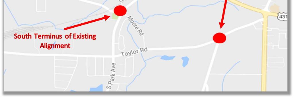
33 FUTURE EXTENSION OF HONEYSUCKLE ROAD In addition to improving the existing Honeysuckle Road alignment, a concept was developed for the extension of Honeysuckle Road from S. Park Avenue to Campbellton Highway. The terminus intersection at the north end would be at S. Park Avenue. Improvements to this intersection will be discussed in more detail later in this report. The south end terminus would be at the Campbellton Highway/Taylor Road intersection. Houston County is currently designing a roundabout at this intersection. In order to determine if the proposed roundabout can accommodate the fourth leg, GS&P prepared a concept layout of the roundabout using the County s design and adding in the fourth leg. Figure 16. Honeysuckle Road Extension Concept 30

34 Figure 17 shows Houston County s proposed roundabout layout with the potential fourth leg of Honeysuckle Road Extension tied in. GS&P reviewed the layout and determined that all movements can be made with the addition of the Honeysuckle Road Extension leg. Figure 17. Honeysuckle Road Extension at Taylor Road/Campbellton Highway Roundabout Concept YEAR 2022, 2027 AND 2037 INTERSECTION LEVELS OF SERVICE Based on the existing lane configurations and traffic control presented in Figure 3, the planned ALDOT improvements at the Honeysuckle Road/W. Main Street intersection and the future AM and PM traffic volumes presented in Figure 6 (Year 2022), Figure 7 (Year 2027) and Figure 8 (Year 2037), peak hour traffic operations were analyzed at the study area intersections using the methodologies outlined in the 2010 Highway Capacity Manual (HCM) and using the Synchro 9.1 software program. The results of the intersection level of service (LOS) analysis for the existing conditions are summarized in Tables 6 (Year 2022), Table 7 (Year 2027) and Table 8 (Year 2037). As shown in Tables 6 through 8, all study area intersections operate at LOS D or better in the AM and PM 31
35 peak hours with the exception of the eastbound approach to the S. Oates Street/Southgate Road intersection, which is projected to operate at LOS F during the AM and PM peak hours, and the S. Park Avenue/Taylor Road intersection which is projected to operate at LOS F in the PM peak hour. Additionally, the southbound approach to the S. Park Avenue/Honeysuckle Road intersection is projected to operate at LOS E in the PM peak hour in the Year The LOS worksheets for the 2022, 2027 and 2037 conditions are provided in Appendix B. Table 6. Year 2022 Intersection Levels of Service Intersection Existing Conditions with ALDOT Improvements at W. Main Street 2022 AM Peak Hour 2022 PM Peak Hour Signalized Intersections (Overall Level of Service) 8: Honeysuckle Road & SR 52 D D 9: Honeysuckle Road & Fortner Street D D 10: Honeysuckle Road/Westgate Parkway & W. Main Street D D Two-Way Stop Controlled Intersections (Worst Approach Level of Service) 1: S. Oates Street & Southgate Road F F 2: Campbellton Highway & Taylor Road B B 3: Taylor Road & Moore Road B C 4: S. Park Avenue & Taylor Road C F 5: S. Park Avenue & Moore Road B C 6: S. Park Avenue & Honeysuckle Road B C 7: S. Park Avenue & Hatton Road A B 32
36 Table 7. Year 2027 Intersection Levels of Service Intersection Existing Conditions with ALDOT Improvements at W. Main Street 2027 AM Peak Hour 2027 PM Peak Hour Signalized Intersections (Overall Level of Service) 8: Honeysuckle Road & SR 52 D D 9: Honeysuckle Road & Fortner Street D D 10: Honeysuckle Road/Westgate Parkway & W. Main Street D D Two-Way Stop Controlled Intersections (Worst Approach Level of Service) 1: S. Oates Street & Southgate Road F F 2: Campbellton Highway & Taylor Road B C 3: Taylor Road & Moore Road B C 4: S. Park Avenue & Taylor Road C F 5: S. Park Avenue & Moore Road C C 6: S. Park Avenue & Honeysuckle Road B D 7: S. Park Avenue & Hatton Road A B Table 8. Year 2037 Intersection Levels of Service Intersection Existing Conditions with ALDOT Improvements at W. Main Street 2037 AM Peak Hour 2037 PM Peak Hour Signalized Intersections (Overall Level of Service) 8: Honeysuckle Road & SR 52 D D 9: Honeysuckle Road & Fortner Street D D 10: Honeysuckle Road/Westgate Parkway & W. Main Street D D Two-Way Stop Controlled Intersections (Worst Approach Level of Service) 1: S. Oates Street & Southgate Road F F 2: Campbellton Highway & Taylor Road C C 3: Taylor Road & Moore Road C D 4: S. Park Avenue & Taylor Road D F 5: S. Park Avenue & Moore Road C C 6: S. Park Avenue & Honeysuckle Road C E 7: S. Park Avenue & Hatton Road A B 33
37 S. PARK AVENUE/HONEYSUCKLE ROAD/HATTON ROAD IMPROVEMENTS Given the close spacing of the Moore Road, Honeysuckle Road and Hatton Road intersections along S. Park Avenue, there are both traffic operations and safety issues at these intersections. As previously mentioned, of the 21 recorded crashes between 2010 and 2015, 9 (or 43 percent) were rear-end crashes. Of the remaining crashes, all but two (fixed object crashes) were due to turning vehicles between the three (3) intersections. To mitigate these existing issues, improvements to the S. Park Avenue/Honeysuckle Road and S. Park Avenue/Hatton Road intersections are recommended, as follows: Relocate Honeysuckle Road so it intersects with S. Park Avenue north of the existing Hatton Road. Hatton Road would remain open only to local traffic at S. Park Avenue. Through traffic on Hatton Road would need to utilize the relocated Honeysuckle Road (see Figure 18). Roundabout at a combined S. Park Avenue/Honeysuckle Road/Hatton Road intersection (see Figure 19). The roundabout was laid out to minimize impacts to the Church and cemetery. However, this option will have business access impacts that will need to be addressed to the mini storage and other business adjacent to Hatton Road. Capacity analysis was performed for both options at this intersection. The LOS for the relocated Honeysuckle Road was calculated using the unsignalized methodology. Roundabout analysis was also performed at this location for the proposed roundabout. The analysis was conducted using the methodologies outlined in the GDOT s Roundabout Analysis Tool v3.1 spreadsheet. This tool uses the analysis methodology outlined in the HCM 2010 Model and is consistent with the HCM. Table 9 shows the results of the capacity analysis for both the relocated Honeysuckle Road and the roundabout. Both options operate at acceptable LOS. The LOS worksheets for the Year 2022, 2027, and 2037 conditions are provided in Appendix B. 34

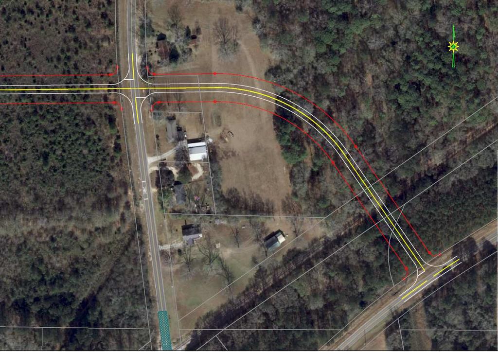
38 Figure 18. S. Honeysuckle Road Realigned Concept 35

 6: S.")
39 Figure 19. S. Park Avenue/Honeysuckle Road/Hatton Road Roundabout Concept Table 9. S. Park Avenue/Honeysuckle Road Improvements Intersection Levels of Service Intersection AM Peak Hour PM Peak Hour AM Peak Hour PM Peak Hour AM Peak Hour PM Peak Hour Roundabout Controlled Intersections (Worst Approach Level of Service) 6: S. Park Avenue & Honeysuckle Road A A A A A A Two-Way Stop Controlled Intersections (Worst Approach Level of Service) 6: S. Park Avenue & Honeysuckle Road Realigned B C B C B C 36
40 EVALUATION OF ADDITIONAL IMPROVEMENTS Additional analysis was undertaken as the following locations: Campbellton Highway/Taylor Road S. Park Avenue/Taylor Road S. Oates Street/Southgate Road Honeysuckle Road between S. Park Avenue and Leslie Road Campbellton Highway/Taylor Road Houston County is currently designing a roundabout at the Campbellton Highway/Taylor Road intersection. A roundabout analysis was performed at this location. The analysis was conducted using the methodologies outlined in the GDOT s Roundabout Analysis Tool v3.1 spreadsheet. This tool uses the analysis methodology outlined in the HCM 2010 Model and is consistent with the HCM. Table 10 shows the results of the preliminary roundabout analysis. Based on the preliminary analysis, a single lane roundabout works well at the Campbellton Highway/Taylor Road intersection under the current three-leg configuration through the Year The levels of service worksheets for the Year 2022, 2027 and 2037 conditions are provided in Appendix B. Table 10. Campbellton Highway/Taylor Road Improvements Intersection Levels of Service Intersection AM Peak Hour PM Peak Hour AM Peak Hour PM Peak Hour Roundabout Controlled Intersections (Worst Approach Level of Service) Campbellton Highway at Taylor Road AM Peak Hour PM Peak Hour A A A A A A Based on the high level of service (LOS A) at this roundabout, it is anticipated that adding the fourth leg with the extension of Honeysuckle Road would have minimal impact on the LOS since a large portion of the expected traffic along Honeysuckle Road extended would come from traffic already projected to use Taylor Road. Therefore, the fourth leg (Honeysuckle Road Extended) would not add a significant amount of traffic to the roundabout, and adequate LOS should be maintained through the Year S. Park Avenue/Taylor Road Currently the S. Park Avenue/ Taylor Road intersection operates under four-way stop control. The existing LOS is F in the PM peak hour and without improvements will continue to operate at LOS F in the future. Two (2) options were considered at this location; a traditional traffic signal and a roundabout. A roundabout analysis was conducted using the methodologies outlined in the GDOT s Roundabout Analysis Tool v3.1 spreadsheet. This tool uses the analysis methodology outlined in the HCM 2010 Model and is consistent with the HCM. Table 11 shows the results of 37

41 the preliminary traffic signal and roundabout analysis. Figure 20 shows the roundabout concept at this intersection. Based on the preliminary analysis, the traditional signal is projected to operate better than a single lane roundabout S. Park Avenue/Taylor Road intersection. It is recommended that the City of Dothan continue to monitor this location to determine when it meets signal warrants. The LOS worksheets for the Year 2022, 2027 and 2037 conditions are provided in Appendix B. Figure 20. S. Park Avenue/ Taylor Road Roundabout Concept Table 11. S. Park Avenue/Taylor Road Improvements Intersection Levels of Service Intersection AM Peak Hour PM Peak Hour AM Peak Hour PM Peak Hour AM Peak Hour PM Peak Hour Roundabout Controlled Intersections (Worst Approach Level of Service) 4: S. Park Avenue & A C A D A E Taylor Road Signalized Intersections (Overall Level of Service) 4: S. Park Avenue & A B A B A B Taylor Road 38
 recorded crashes, all four (4) were related to the unsignalized median opening at Southgate Road.")
 potential improvements at this location are to provide a restricted crossing U-turn (RCUT) intersection, a traffic signal, or a directional median with an acceleration lane for the")
42 S. Oates Street/Southgate Road As described previously, there are five (5) median openings on S. Oates Street in the approximately 1,775 feet between Southgate Road and W. Inez Road, including traffic signals at the Walmart Access and W. Inez Road. Of the four (4) recorded crashes, all four (4) were related to the unsignalized median opening at Southgate Road. Crashes are projected to increase with the additional traffic related to opening of Oates Park. Three (3) potential improvements at this location are to provide a restricted crossing U-turn (RCUT) intersection, a traffic signal, or a directional median with an acceleration lane for the eastbound left-turning movement. The RCUT is characterized by the prohibition of left-turn and through movements from side street approaches as permitted in conventional intersection designs. Instead, the RCUT intersection accommodates these movements by requiring drivers to turn right onto the main road and then make a U-turn maneuver at an opening 400 to 1,000 feet after the intersection. Left turns from the main road approaches are executed in a manner similar to left turns at conventional intersections and are unchanged in this design. Figure 21 shows the RCUT concept at this intersection. Figure 21. S. Oates Street/Southgate Road RCUT Concept The directional median with acceleration lane concept would allow the northbound left and eastbound left turning movements while restricting all other traffic through the median. An acceleration lane is provided for the eastbound left turning movement to facilitate merging with the northbound traffic. Figure 22 shows the directional median concept. 39


43 Figure 22. S. Oates Street/Southgate Road Directional Median Concept Table 12 shows the projected LOS for the three concepts. While the LOS for a traffic signal is better than the RCUT, it should be noted that the LOS for the signal is for the entire intersection and the LOS for the RCUT is for the worst movement. At the RCUT, the mainline traffic is not stopped so there is no delay for most vehicles at the intersection. There is also a safety benefit to the RCUT since high speed through traffic does not have to stop at the intersection with the RCUT. The other advantage of the RCUT is signal spacing. Adding an additional signal at Southgate Road, would make three (3) traffic signals in approximately 1,775 feet. The close signal spacing could impact progression of the through traffic on the mainline. Given the safety and operational benefit of the RCUT, this alternative is recommended at this intersection. 40
44 Table 12. S. Oates Street/Southgate Road Improvements Intersection Levels of Service Intersection AM Peak Hour PM Peak Hour AM Peak Hour PM Peak Hour AM Peak Hour PM Peak Hour Two-Way Stop Controlled RCUT Intersection (Worst Approach Level of Service) 1: S. Oates Road & B C B C C D Southgate Road Two-Way Stop Controlled Directional Median with Acceleration Lane (Worst Approach Level of Service) 1: S. Oates Road & F F F F F F Southgate Road Signalized Intersection (Overall Level of Service) 1: S. Oates Road & A A A B A B Southgate Road Honeysuckle Road between S. Park Avenue and Leslie Road One additional improvement that should be considered is to correct the superelevation of the curve on Honeysuckle Road just south of Homestead Road. This improvement should consist of: Add asphalt leveling to provide the correct superelevation. Given the compound radius, the superelevation could be transitioned from 6.89% on the south end of the curve to 7.85% at the north end of the curve, or, due to the relatively short curve length, a 7.85% superelevation could be used for the entire curve. An appropriate superelevation transition should also be constructed (with asphalt leveling) with 80% of the transition occurring outside of the curve and 20% of the transition occurring inside the curve. Add a two foot (2 ) wide paved shoulder with scoring (by cutting) on both sides of the road. An additional two feet (2 ) of graded shoulder is also recommended on both sides. This improvement is purely a safety improvement and does not provide any increased capacity or LOS in this section of Honeysuckle Road. 41
45 IMPROVEMENT COST ESTIMATES Detailed concept cost estimates were developed for each of the concepts and for the additional recommended improvements based on ALDOT historical bid unit prices and include the following: Grading Construction Maintenance of Traffic (Traffic Handling) Erosion Control Preliminary Engineering Mobilization Construction Engineering & Inspection (CE&I) (for federally funded projects) Utility Relocation Right-of-Way Cost (Residential and Commercial) ALDOT Indirect Costs (for federally funded projects) All costs were estimated in 2018 dollars utilizing a four (4) percent increase from 2017 unit prices. Detailed cost estimates were developed for following Honeysuckle Roadway Concepts: Concept A Widening with Trail Concept Concept B Widening with Bike Lanes and Sidewalks Concept Concept C Widening with No Sidewalks/Trails or Bike Lanes Concept D Widening with No Trails or Bike Lanes with Sidewalk on One Side (from W. Main Street to SR 52) Other improvements cost estimates that were developed include: Honeysuckle Road Extension - S. Park Avenue to Campellton Highway (for future planning) Realigned Honeysuckle Road - Homestead Road to S. Park Avenue Roundabout at Honeysuckle Road/Hatton Road/S. Park Avenue Roundabout at S. Park Avenue/Taylor Road Restricted Crossing U-turn (RCUT) at S. Oates Street at Southgate Road Directional Median with Acceleration Lane at S. Oates Street at Southgate Road Superelevation Correction on Honeysuckle Road just south of Homestead Road Table 13 shows the concept cost estimates for the Honeysuckle Road improvements and the other improvements. These improvements were based on the following assumptions: Concept A (Trail Concept): 12-foot multi-use trail on the west side of the road along with a five foot sidewalk on the east side of the road for the entire concept. Honeysuckle Road from W. Main Street to Fortner Street - the typical section is a 4-lane divided roadway with 11-foot lanes and 15 raised median with left turn bays at key 42
46 intersections. The trail and sidewalk will be constructed from W. Main Street to Fortner Street. Fortner Street to SR 52 - it is a three-lane undivided with a median turn lane. There are portions of existing sidewalks on the east side of Honeysuckle through these limits. Connections to these sidewalks will be made to make a continuous sidewalk along the east side. At Honeysuckle Middle School, a right turn lane and sidewalk are added. The sidewalk will connect to the existing sidewalk north and south of the school. There is also a second section of sidewalk that will be added on the east side near the Fortner Street intersection. For this section, sidewalk connections on the east with full trail for the entire section on the west side. SR 52 to S. Park Avenue - it is two-lane undivided roadway with the 12-foot trail on the west side only, no sidewalk construction on the east side, and proposed 4-foot shoulders (east and west sides which can actually be used as bike lanes) with no curb and gutter. This section was designed so that a third lane could be added and the trail would not be impacted. The main construction items include grading, base & paving, overlay, 12-foot trail, five foot sidewalk, curb & gutter, and sod for each section. Figure 11 shows the different typical sections for this concept. Detailed concept drawings were developed for Concept A (Trail Concept) and is shown in Appendix C. The cost estimate for Concept A is shown in Appendix F. Concept B (Bike Lane and Sidewalk Concept): Five-foot bike lane with five-foot sidewalks on both the east and west side of the roadway. Honeysuckle Road from W. Main Street to Fortner Street - it is a 4-lane divided roadway with 11-foot lanes and median turn bays. The bike lanes and sidewalks will be constructed for the entire section. Fortner Street to SR 52 - it is a three-lane undivided with a median turn lane. The bike lanes and sidewalks will be constructed for the entire section. SR 52 to S. Park Avenue - it is two-lane undivided roadway with the five-foot trail on the west side only, no sidewalk construction on the east side, and proposed 4-foot shoulders as the bike lanes (east and west sides) with no curb and gutter. This section was designed so that a third lane could be added and the sidewalk would not be impacted. The main construction items include grading, base & paving, overlay, 12-foot trail, five foot sidewalk, curb & gutter, and sod for each section. Figure 12 shows the different typical sections for this concept. Detailed concept drawings were developed for Concept B (Bike Lane and Sidewalk Concept) and is shown in Appendix C. The cost estimate for Concept B is shown in Appendix F. Concept C (Widening with No Sidewalks/Trails or Bike Lanes): This concept assumes widening to the required width, however, no sidewalks, trails or bike lane additions. Honeysuckle Road from W. Main Street to Fortner Street - it is a 4-lane divided roadway with 11-foot lanes and median turn bays. No trails, sidewalks or bike lanes proposed for the entire section. 43
47 Fortner Street to SR 52 - it is a three-lane undivided with a median turn lane. At Honeysuckle Middle School, a right turn lane and sidewalk are added. Sidewalk is added in this section due to construction for the turn lane and to tie in the sidewalk at the school. It is cheaper to build the sidewalk while constructing the turn lane than to do it later. The sidewalk will connect to the existing sidewalk north and south of the school. No other sidewalk, trails or bike lanes will be proposed for this section. SR 52 to S. Park Avenue - it is two-lane undivided roadway. No work completed in this section in Concept C. The main construction items include grading, base & paving, overlay, five foot sidewalk (at Honeysuckle Middle School), curb & gutter, and sod for each section. The typical sections for this concept are shown in Figure 13. Detailed concept drawings were developed for Concept C (Widening with No Sidewalks/Trails or Bike Lanes Concept) and is shown in Appendix C. The cost estimate for Concept C is shown in Appendix F. Concept D (Widening with No Trails or Bike Lanes with Sidewalk on One Side from W. Main Street to SR 52): This concept assumes widening to required width, with a sidewalk as detailed below. Honeysuckle Road from W. Main Street to Fortner Street - it is a 4-lane divided roadway with 11-foot lanes and median turn bays. Sidewalk proposed on the west side for the entire section. Fortner Street to SR 52 - it is a three-lane undivided with a median turn lane. At Honeysuckle Middle School, a right turn lane and sidewalk are added. Sidewalk is added in this section due to construction for the turn lane and to tie in the sidewalk at the school. The sidewalk will connect to the existing sidewalk north and south of the school. There is also a second section of sidewalk that will be added on the east side near the Fortner Street intersection. Sidewalk connections proposed for this section. From SR 52 to Folsom Road, it is two-lane undivided roadway. No work completed in this section in Concept D. The main construction items include grading, base & paving, overlay, five foot sidewalk, curb & gutter, and sod for each section. The typical sections for this concept are shown in Figure 14. Detailed concept drawings were developed for Concept D (Widening with No Sidewalks/Trails with Sidewalk on One Side from W. Main Street to SR 52) and is shown in Appendix C. The cost estimate for Concept D is shown in Appendix F. 44
48 Concept Table 13. Summary of Concept Cost Estimates W. Main Street to Fortner Street (4 Lanes) Fortner Street to SR 52 (3 Lanes) SR 52 to S. Park Avenue (2 Lanes) Total Cost Estimate Honeysuckle Road Concepts Concept A Widening with Trail $11,980,200 $3,151,600 $2,044,100 $17,175,900 Concept B Widening with Bike Lanes & Sidewalks Concept C - Widening with No Sidewalks/Trails/or Bike Lanes Concept D - Widening with No Trails or Bike Lanes, Sidewalk on One Side (from W. Main Street to SR-52) $12,820,100 $4,667,900 $1,904,300 $19,392,300 $9,593,000 $1,034,300 $0 $10,627,300 $10,918,200 $1,073,400 $0 $11,991,600 Other Improvements Honeysuckle Road Extension - S. Park Avenue to Campellton Highway (for future planning) $2,847,900 Realigned Honeysuckle Road - Homestead Road to S. Park Avenue $3,916,700 Roundabout at Honeysuckle Road/Hatton Street/S. Park Avenue $2,356,800 Roundabout at S. Park Avenue/Taylor Road $1,592,300 Restricted Crossing U-turn (RCUT) at S. Oates Street at Southgate Road $522,100 Directional Median with Acceleration Lane at S. Oates Street at Southgate Road $57,800 Superelevation Correction on Honeysuckle Road just south of Homestead Road $385,600 45

49 PUBLIC INVOLVEMENT MEETING SUMMARY On September 19th, 2017, a public involvement meeting for the Honeysuckle Road Corridor Study was held, from 5:00 pm to 7:00 pm, at the Selma Baptist Church on S. Park Avenue in Dothan, AL. There were 64 attendees who signed in, with 43 of the residential or business attendees providing their address. Figure 23 shows the location of these 43 residential and business attendees. Figure 23. Home or Business Location of Attendees 46
Glenn Avenue Corridor Traffic Operational Evaluation
 Glenn Avenue Corridor Traffic Operational Evaluation PREPARED FOR: THE CITY OF AUBURN PREPARED BY: DECEMBER 2007 Glenn Avenue Corridor Study--Auburn, Alabama TABLE OF CONTENTS Introduction... 1 Background
Evaluation of M-99 (Broad Street) Road Diet and Intersection Operational Investigation
 Road Diet and Intersection Operational Investigation") Evaluation of M-99 (Broad Street) Road Diet and Intersection Operational Investigation City of Hillsdale, Hillsdale County, Michigan June 16, 2016 Final Report Prepared for City of Hillsdale 97 North Broad
Evaluation of M-99 (Broad Street) Road Diet and Intersection Operational Investigation City of Hillsdale, Hillsdale County, Michigan June 16, 2016 Final Report Prepared for City of Hillsdale 97 North Broad
5858 N COLLEGE, LLC N College Avenue Traffic Impact Study
 5858 N COLLEGE, LLC nue Traffic Impact Study August 22, 2016 Contents Traffic Impact Study Page Preparer Qualifications... 1 Introduction... 2 Existing Roadway Conditions... 5 Existing Traffic Conditions...
Donahue Drive Corridor Traffic Operational Evaluation
 Donahue Drive Corridor Traffic Operational Evaluation PREPARED FOR: THE CITY OF AUBURN PREPARED BY: JANUARY 2007 Donahue Drive Corridor Study--Auburn, Alabama TABLE OF CONTENTS Introduction... 1 Background
Traffic Impact Analysis Walton Acres at Riverwood Athletic Club Clayton, NC
 Traffic Impact Analysis Walton Acres at Riverwood Athletic Club Clayton, NC 1. TABLE OF CONTENTS INTRODUCTION...1 1.1. Site Location and Study Area...1 1.2. Proposed Land Use and Site Access...2 1.3.
Traffic Impact Study WestBranch Residential Development Davidson, NC March 2016
 Traffic Impact Study WestBranch Residential Development Davidson, NC March 216 TRAFFIC IMPACT STUDY FOR THE WestBranch Residential Development LOCATED IN DAVIDSON, NC Prepared For: Lennar Carolinas, LLC
TRAFFIC IMPACT STUDY COMPREHENSIVE UPDATE TOWN OF THOMPSON S STATION, TENNESSEE PREPARED FOR: THE TOWN OF THOMPSON S STATION
 TRAFFIC IMPACT STUDY COMPREHENSIVE UPDATE TOWN OF THOMPSON S STATION, TENNESSEE PREPARED FOR: THE TOWN OF THOMPSON S STATION Transportation Consultants, LLC 1101 17 TH AVENUE SOUTH NASHVILLE, TN 37212
TRAFFIC IMPACT ANALYSIS
 TRAFFIC IMPACT ANALYSIS FOR THE CHAMPAIGN UNIT#4 SCHOOL DISTRICT PROPOSED HIGH SCHOOL (SPALDING PARK SITE) IN THE CITY OF CHAMPAIGN Final Report Champaign Urbana Urbanized Area Transportation Study 6/24/2014
Traffic Impact Analysis Chatham County Grocery Chatham County, NC
 Chatham County Grocery Chatham County, NC TABLE OF CONTENTS 1. INTRODUCTION... 1 1.1. Location and Study Area... 1 1.2. Proposed Land Use and Access... 2 1.3. Adjacent Land Uses... 2 1.4. Existing ways...
Truck Climbing Lane Traffic Justification Report
 ROUTE 7 (HARRY BYRD HIGHWAY) WESTBOUND FROM WEST MARKET STREET TO ROUTE 9 (CHARLES TOWN PIKE) Truck Climbing Lane Traffic Justification Report Project No. 6007-053-133, P 101 Ι UPC No. 58599 Prepared by:
Chapter 5 DATA COLLECTION FOR TRANSPORTATION SAFETY STUDIES
 Chapter 5 DATA COLLECTION FOR TRANSPORTATION SAFETY STUDIES 5.1 PURPOSE (1) The purpose of the Traffic Safety Studies chapter is to provide guidance on the data collection requirements for conducting a
Chapter 4 Traffic Analysis
 Chapter 4 Traffic Analysis PURPOSE The traffic analysis component of the K-68 Corridor Management Plan incorporates information on the existing transportation network, such as traffic volumes and intersection
Transportation Impact Study for Abington Terrace
 Transportation Impact Study for Abington Terrace Abington Township, Montgomery County, PA Sandy A. Koza, P.E., PTOE PA PE License Number PE059911 Prepared by McMahon Associates, Inc. 425 Commerce Drive,
TRANSPORTATION ANALYSIS REPORT US Route 6 Huron, Erie County, Ohio
 TRANSPORTATION ANALYSIS REPORT US Route 6 Huron, Erie County, Ohio December 12, 2012 Prepared for: The City of Huron 417 Main Huron, OH 44839 Providing Practical Experience Technical Excellence and Client
THIS PAGE LEFT BLANK INTENTIONALLY
 GA SR 25 Spur at Canal Road Transportation Impact Analysis PREPARED FOR GLYNN COUNTY, GEORGIA 1725 Reynolds Street, Suite 300 Brunswick, Georgia 31520 PREPARED BY 217 Arrowhead Boulevard Suite 26 Jonesboro,
Intersection Traffic Control Feasibility Study
 Intersection Traffic Control Feasibility Study CSAH 9 at CSAH 60 (185th Avenue) Prepared For: Dakota County Transportation Department Western Service Center 14955 Galaxie Avenue, 3rd Floor Apple Valley,
TRAFFIC ASSESSMENT River Edge Colorado
 TRAFFIC ASSESSMENT River Edge Colorado Submitted by: Fehr & Peers 621 17th Street, Ste. 231 Denver, CO 8293 (33) 296-43 December, 21 App. M-2 Traffic Assessment River Edge Colorado December 21 TABLE OF
TABLE OF CONTENTS TABLE OF CONTENTS... I APPENDICES... III LIST OF EXHIBITS... V LIST OF TABLES... VII LIST OF ABBREVIATED TERMS...
 TABLE OF CONTENTS TABLE OF CONTENTS... I APPENDICES... III LIST OF EXHIBITS... V LIST OF TABLES... VII LIST OF ABBREVIATED TERMS... IX 1 INTRODUCTION... 1 1.1 Project Overview... 1 1.2 Analysis Scenarios...
Small Area Study U.S. Route 220 and VA Route 615 Intersection. Bath County, Virginia
 Small Area Study U.S. Route 220 and VA Route 615 Intersection Bath County, Virginia Prepared by the Central Shenandoah Planning District Commission Final Report February 2018 Table of Contents 1. INTRODUCTION...
133 rd Street and 132 nd /Hemlock Street 132 nd Street and Foster Street MINI ROUNDABOUTS. Overland Park, Kansas
 133 rd Street and 132 nd /Hemlock Street 132 nd Street and Foster Street MINI ROUNDABOUTS Overland Park, Kansas September 1, 2017 TABLE OF CONTENTS 1. INTRODUCTION... 1 2. LITERATURE REVIEW... 1 3. CONCEPT
Appendix C. NORTH METRO STATION AREA TRAFFIC IMPACT STATEMENT 88th Avenue Station
 Appendix C NORTH METRO STATION AREA TRAFFIC IMPACT STATEMENT 88th Avenue Station Prepared for: Regional Transportation Department and URS Corporation as part of the North Metro EIS David Evans and Associates,
APPENDIX G: INTERSECTION NEEDS AT OKEECHOBEE BOULEVARD
 APPENDIX G: INTERSECTION NEEDS AT OKEECHOBEE BOULEVARD INTERSECTION NEEDS AT SR 7 and OKEECHOBEE BOULEVARD SR 7 Extension Project Development and Environment (PD&E) Study From Okeechobee Boulevard (SR
Recommended Roadway Plan Section 2 - Land Development and Roadway Access
 Recommended Roadway Plan Section 2 - Land Development and Roadway Access SECTION 2 Land Development and Roadway Access 2.1 Land Use and Access Management The Federal Highway Administration (FHWA) defines
Highway 111 Corridor Study
 Highway 111 Corridor Study June, 2009 LINCOLN CO. HWY 111 CORRIDOR STUDY Draft Study Tea, South Dakota Prepared for City of Tea Sioux Falls Metropolitan Planning Organization Prepared by HDR Engineering,
CarMax Auto Superstore/ Reconditioning Center #6002 Murrieta, California
 CarMax Auto Superstore/ Reconditioning Center #6002 Murrieta, California TUSTIN 17782 17th Street Suite 200 Tustin, CA 92780-1947 714.665.4500 Fax: 714.665.4501 LOS ANGELES 145 S. Spring Street Suite 120
Traffic Impact Study. Westlake Elementary School Westlake, Ohio. TMS Engineers, Inc. June 5, 2017
 TMS Engineers, Inc. Traffic Impact Study Westlake Elementary School Westlake, Ohio June 5, 2017 Prepared for: Westlake City Schools - Board of Education 27200 Hilliard Boulevard Westlake, OH 44145 TRAFFIC
DIMARCO CANANDAIGUA PROPERTIES HOUSING PROJECT CANANDAIGUA, ONTARIO COUNTY, NEW YORK
 TRAFFIC IMPACT STUDY FOR THE DIMARCO CANANDAIGUA PROPERTIES HOUSING PROJECT CANANDAIGUA, ONTARIO COUNTY, NEW YORK MARCH 14, 2017 PREPARED FOR: 1950 Brighton Henrietta Town Line Rd Rochester, NY 14623 PREPARED
Grant Avenue Streetscape
 REPORT TYPE GOES HERE Grant Avenue Streetscape PREPARED FOR City of Manassas 9027 Center Street Manassas, VA 20110 PREPARED BY 8300 Boone Boulevard Suite 700 Vienna, Virginia 22182 571.389.8121 July 31,
FINAL DESIGN TRAFFIC TECHNICAL MEMORANDUM
 FINAL DESIGN TRAFFIC TECHNICAL MEMORANDUM July 2014 FINAL (SR 43) Project Development and Environment Study From State Road 60 (Adamo Drive) to I-4 (SR 400) Hillsborough County, Florida Work Program Item
List of Attachments. Location Map... Site Plan... City of Lake Elsinore Circulation Element... City of Lake Elsinore Roadway Cross-Sections...
 List of Attachments Exhibits Location Map... Site Plan... City of Lake Elsinore Circulation Element... City of Lake Elsinore Roadway Cross-Sections... Existing Lane Geometry and Traffic Controls... Existing
1609 E. FRANKLIN STREET HOTEL TRAFFIC IMPACT STUDY EXECUTIVE SUMMARY
 1609 E. FRANKLIN STREET HOTEL TRAFFIC IMPACT STUDY EXECUTIVE SUMMARY Prepared for: The Town of Chapel Hill Public Works Department Traffic Engineering Division Prepared by: HNTB North Carolina, PC 343
Bridge Street Corridor Study Report
 Bridge Street Corridor Study Report Prepared for: Prepared by: BRIDGE STREET CORRIDOR STUDY REPORT PREPARED FOR: CITY OF ARROYO GRANDE COMMUNITY DEVELOPMENT DEPARTMENT 300 EAST BRANCH STREET ARROYO GRANDE,
4.0 TRAFFIC IMPACT STUDIES
 SECTION 4 4.0 TRAFFIC IMPACT STUDIES 4.1 TRAFFIC IMPACT STUDY REQUIREMENTS The City has established Traffic Impact Study (TIS) requirements for the purpose of ensuring that both the quantitative and qualitative
Figure 1: Vicinity Map of the Study Area
 ARIZONA TEXAS NEW MEXICO OKLAHOMA May 5, 2016 Mr. Anthony Beach, P.E. BSP Engineers 4800 Lakewood Drive, Suite 4 Waco, Texas 76710 Re: Intersection and Access Analysis along Business 190 in Copperas Cove
Walmart (Store # ) 60 th Street North and Marion Road Sioux Falls, South Dakota
 60 th Street North and Marion Road Sioux Falls, South Dakota") Walmart (Store #4865-00) 60 th Street North and Marion Road Sioux Falls, South Dakota Prepared for: Wal-Mart Stores, Inc. Bentonville, Arkansas Prepared by: Kimley-Horn and Associates, Inc. ã2013 Kimley-Horn
Walmart (Store #4865-00) 60 th Street North and Marion Road Sioux Falls, South Dakota Prepared for: Wal-Mart Stores, Inc. Bentonville, Arkansas Prepared by: Kimley-Horn and Associates, Inc. ã2013 Kimley-Horn
Figure 1: East West Connector Alignment Alternatives Concept Drawing
 Page 2 of 9 Figure 1: East West Connector Alignment Alternatives Concept Drawing The Montebello Drive extension will run north south and connect Wilsonville Road to the Boones Ferry Road to Brown Road
ALLEY 24 TRAFFIC STUDY
 ALLEY 24 TRAFFIC STUDY in City of Frostburg, Maryland January 2013 3566 Teays Valley Road Hurricane, WV Office: (304) 397-5508 www.denniscorporation.com Alley 24 Traffic Study January 2013 Frostburg, Maryland
Traffic Impact Study Little Egypt Road Development Denver, North Carolina June 2017
 Traffic Impact Study Little Egypt Road Development Denver, North arolina June 2017 N. Little Egypt Road DQ\ QDQFLQJ VDOHV RU RWKHU SHUIRUPDQFH EDVHG FULWHULD Proposed Site Driveways Site Driveway 1 TRAFFI
Shockoe Bottom Preliminary Traffic and Parking Analysis
 Shockoe Bottom Preliminary Traffic and Parking Analysis Richmond, Virginia August 14, 2013 Prepared For City of Richmond Department of Public Works Prepared By 1001 Boulders Pkwy Suite 300, Richmond, VA
METHODOLOGY. Signalized Intersection Average Control Delay (sec/veh)
") Chapter 5 Traffic Analysis 5.1 SUMMARY US /West 6 th Street assumes a unique role in the Lawrence Douglas County transportation system. This principal arterial street currently conveys commuter traffic
Chapter 5 Traffic Analysis 5.1 SUMMARY US /West 6 th Street assumes a unique role in the Lawrence Douglas County transportation system. This principal arterial street currently conveys commuter traffic
Project Report. South Kirkwood Road Traffic Study. Meadows Place, TX October 9, 2015
 Meadows Place, TX October 9, 2015 Contents 1 Introduction... 1 2 Data Collection... 1 3 Existing Roadway Network... 2 4 Traffic Volume Development... 2 5 Warrant Analysis... 3 6 Traffic Control Alternative
Traffic Impact Study. Roderick Place Columbia Pike Thompson s Station, TN. Transportation Group, LLC Traffic Engineering and Planning
 F i s c h b a c h Transportation Group, LLC Traffic Engineering and Planning Traffic Impact Study Roderick Place Columbia Pike Thompson s Station, TN Prepared March 2016 Ms. Gillian L. Fischbach, P.E.,
TRAFFIC IMPACT STUDY CRITERIA
 Chapter 6 - TRAFFIC IMPACT STUDY CRITERIA 6.1 GENERAL PROVISIONS 6.1.1. Purpose: The purpose of this document is to outline a standard format for preparing a traffic impact study in the City of Steamboat
Highway 49, Highway 351 and Highway 91 Improvements Feasibility Study Craighead County
 Highway 49, Highway 351 and Highway 91 Improvements Feasibility Study Craighead County Executive Summary March 2015 Highway 49, Highway 351 and Highway 91 Improvements Feasibility Study Craighead County
TRAFFIC IMPACT STUDY. Creekside Thornton, Colorado. For. August 2015 November 2015 Revised: August Prepared for:
 TRAFFIC IMPACT STUDY For Creekside Thornton, Colorado August 215 November 215 Revised: August 216 Prepared for: Jansen Strawn Consulting Engineers 45 West 2 nd Avenue Denver, Colorado 8223 Prepared by:
Queensgate Drive Corridor Traffic Study
 January 2015 Prepared for: City of Richland Prepared by: J-U-B ENGINEERS, Inc. 2810 W. Clearwater Avenue, Suite 201 Kennewick, Washington 99336 Table of Contents Introduction and Background... 1 Existing
Route 28 (South Orleans Road)/Route 39 (Harwich Road)/Quanset Road Intersection
/Route 39 (Harwich Road)/Quanset Road Intersection") TRAFFIC FEASIBILITY STUDY Route 28 (South Orleans Road)/Route 39 (Harwich Road)/Quanset Road Intersection Orleans, Massachusetts Prepared for: Town of Orleans Prepared by: Fay, Spofford & Thorndike, LLC
TRAFFIC FEASIBILITY STUDY Route 28 (South Orleans Road)/Route 39 (Harwich Road)/Quanset Road Intersection Orleans, Massachusetts Prepared for: Town of Orleans Prepared by: Fay, Spofford & Thorndike, LLC
MUTCD Part 6G: Type of Temporary Traffic Control Zone Activities
 MUTCD Part 6G: Type of Temporary Traffic Control Zone Activities 6G.01 Typical Applications Each temporary traffic control (TTC) zone is different. Many variables, such as location of work, highway type,
TRAFFIC STUDY GUIDELINES Clarksville Street Department
 TRAFFIC STUDY GUIDELINES Clarksville Street Department 9/1/2009 Introduction Traffic studies are used to help the city determine potential impacts to the operation of the surrounding roadway network. Two
WYDOT DESIGN GUIDES. Guide for. Non-NHS State Highways
 WYDOT DESIGN GUIDES Guide for Non-NHS State Highways 2014 GUIDE FOR Non-NATIONAL HIGHWAY SYSTEM (Non-NHS) STATE HIGHWAYS PRESERVATION REHABILITATION RECONSTRUCTION INTRODUCTION This Guide is directed to
DUNBOW ROAD FUNCTIONAL PLANNING
 DUNBOW ROAD FUNCTIONAL PLANNING Final Report August 3, 216 #31, 316 5th Avenue NE Calgary, AB T2A 6K4 Phone: 43.273.91 Fax: 43.273.344 wattconsultinggroup.com Dunbow Road Functional Planning Final Report
4. ENVIRONMENTAL IMPACT ANALYSIS 9. TRANSPORTATION AND TRAFFIC
 4. ENVIRONMENTAL IMPACT ANALYSIS 9. TRANSPORTATION AND TRAFFIC 4.9.1 INTRODUCTION The following section addresses the Proposed Project s impact on transportation and traffic based on the Traffic Study
Traffic Analysis and Design Report. NW Bethany Boulevard. NW Bronson Road to NW West Union Road. Washington County, Oregon
 Traffic Analysis and Design Report NW Bethany Boulevard NW Bronson Road to NW West Union Road Washington County, Oregon May 2011 Table of Contents Table of Contents Section 1 Executive Summary... 2 Section
TRAFFIC IMPACT STUDY And A TRAFFIC SIGNAL WARRANT ANALYSIS FOR A SENIOR LIVING AND APARTMENT DEVELOPMENT
 TRAFFIC IMPACT STUDY And A TRAFFIC SIGNAL WARRANT ANALYSIS FOR A SENIOR LIVING AND APARTMENT DEVELOPMENT DEERFIELD TOWNSHIP, WARREN COUNTY, OHIO Nantucket Circle and Montgomery Road () Prepared for: ODLE
Cheyenne Metropolitan Planning Organization
 Dell Range Boulevard Corridor Study PHASE II SECTION 20 DRAFT Prepared for: Cheyenne Metropolitan Planning Organization November 20, 2015 (Section 20 is bordered by Powderhouse Road on the west, Storey
Roundabout Feasibility Memorandum
 Roundabout Feasibility Memorandum To From Gwen Pipkin Bill Howell Date June 18, 2013 Subject Roundabout Feasibility Study SR 29 PD&E Study From Oil Well Road to SR 82 Collier County, FL FPID 417540-1-22-01
WYDOT DESIGN GUIDES. Guide for. NHS Arterial (Non-Interstate)
") WYDOT DESIGN GUIDES Guide for NHS Arterial (Non-Interstate) 2014 GUIDE FOR NATIONAL HIGHWAY SYSTEM (NHS) HIGHWAYS (NHS ARTERIALS, Non-Interstate) PRESERVATION REHABILITATION RECONSTRUCTION INTRODUCTION
WYDOT DESIGN GUIDES Guide for NHS Arterial (Non-Interstate) 2014 GUIDE FOR NATIONAL HIGHWAY SYSTEM (NHS) HIGHWAYS (NHS ARTERIALS, Non-Interstate) PRESERVATION REHABILITATION RECONSTRUCTION INTRODUCTION
JONESBORO HIGHWAY 63 HIGHWAY 18 CONNECTOR STUDY
 JONESBORO HIGHWAY 63 HIGHWAY 18 CONNECTOR STUDY Craighead County May 2007 JONESBORO HIGHWAY 63 HIGHWAY 18 CONNECTOR STUDY Craighead County May 2007 Prepared by Planning and Research Division Arkansas State
THE FUTURE OF THE TxDOT ROADWAY DESIGN MANUAL
 THE FUTURE OF THE TXDOT ROADWAY DESIGN MANUAL Kenneth Mora, P.E. (Design Division) 10/10/2017 Table of contents 1 2 Reduction in FHWA design controlling criteria Innovative Intersection Guidance 3-7 8-42
City of Homewood Transportation Plan
 City of Homewood Transportation Plan Prepared for: City of Homewood, Alabama Prepared by: Skipper Consulting, Inc. May 2007 TABLE OF CONTENTS INTRODUCTION... 1 BACKGROUND INFORMATION... 1 EXISTING TRANSPORTATION
INTERSECTION SAFETY STUDY State Route 57 / Seville Road
 INTERSECTION SAFETY STUDY State Route 57 / Seville Road City of Wadsworth, Medina County, Ohio Prepared For: City of Wadsworth Engineering Department 120 Maple Street Wadsworth, OH 44281 Prepared By: GPD
Design Traffic Technical Memorandum
 State Road 7 Extension PD&E Study Design Traffic Technical Memorandum Palm Beach County, FL October 2010 State Road 7 Extension PD&E Study Design Traffic Technical Memorandum Palm Beach County, FL Prepared
Clay Street Realignment Project Traffic Study
 Final Clay Street Realignment Project Traffic Study November 24, 2009 Prepared for: City of Placerville RS07-2466 2990 Lava Ridge Court, Suite 200 Roseville, CA 95661 (916) 773-1900 Fax (916) 773-2015
Public Information Meeting. Orange Camp Road. Dr. Martin Luther King Jr. Beltway to I-4. Presented by: Volusia County August 2, 2018
 Public Information Meeting Orange Camp Road Dr. Martin Luther King Jr. Beltway to I-4 Presented by: Volusia County August 2, 2018 1 Project Goals To improve the operations and safety for Orange Camp Road
FRONT RANGE CROSSINGS TRAFFIC IMPACT STUDY
 FRONT RANGE CROSSINGS TRAFFIC IMPACT STUDY Prepared for: City of Thornton And Colorado Department of Transportation Prepared by: 11 Blake Street, Suite 2 Denver, Colorado 822 Contact: Brian Bern, PE, PTOE
Los Altos Hills Town Council - June 18, 2015 Palo Alto City Council June 22, AGENDA ITEM #2.B Presentation
 Los Altos Hills Town Council - June 18, 2015 Palo Alto City Council June 22, 2015 AGENDA ITEM #2.B Presentation Previous Presentations Los Altos Hills Town Council in May 2014 and February 2015 Palo Alto
CITY OF OAKLAND. 27th Street Bikeway Feasibility and Design. Final Report (v3) March 23, Kimley-Horn and Associates, Inc.
 March 23, Kimley-Horn and Associates, Inc.") CITY OF OAKLAND 27th Street Bikeway Feasibility and Design Final Report (v3) March 23, 2007 PREPARED BY: Kimley-Horn and Associates, Inc. Table of Contents 1. Introduction 3 2. 27 th Street/Bay Place Corridor
CITY OF OAKLAND 27th Street Bikeway Feasibility and Design Final Report (v3) March 23, 2007 PREPARED BY: Kimley-Horn and Associates, Inc. Table of Contents 1. Introduction 3 2. 27 th Street/Bay Place Corridor
APPENDIXB. Traffic Operations Technical Memorandum
 APPENDIXB Traffic Operations Technical Memorandum Environmental Assessment - Lincoln County, SD 85 th Street: Sundowner Avenue to Louise Avenue November 2017 MEMORANDUM Transportation Jim Kollbaum, PE
Subject: Solberg Avenue / I-229 Grade Separation: Traffic Analysis
 MEMORANDUM Transportation Bill Troe, AICP Jason Carbee, AICP 12120 Shamrock Plaza Suite 300 Omaha, NE 68154 (402) 334-8181 (402) 334-1984 (Fax) To: Project File Date: Subject: Solberg Avenue / I-229 Grade
DEPARTMENT OF ENVIRONMENTAL SERVICES. North Harrison Street (Lee Highway to Little Falls Road) Comparative Analysis. Prepared for:
 Comparative Analysis. Prepared for:") DEPARTMENT OF ENVIRONMENTAL SERVICES North Harrison Street (Lee Highway to Little Falls Road) Comparative Analysis Prepared for: Arlington County Department of Environmental Services 2100 Clarendon Boulevard,
DEPARTMENT OF ENVIRONMENTAL SERVICES North Harrison Street (Lee Highway to Little Falls Road) Comparative Analysis Prepared for: Arlington County Department of Environmental Services 2100 Clarendon Boulevard,
3.0 PROJECT DESCRIPTION
 The following section of the Draft EIR contains a description of the proposed Elk Grove Boulevard/SR 99 Interchange Modification project, consistent with the requirements of CEQA Guidelines Section 15124.
3.0 ACCESS CONTROL PLAN - HARMONY ROAD (SH68)
") 3.0 ACCESS CONTROL PLAN - HARMONY ROAD (SH68) 3.1 Existing Conditions Roadway Physical Characteristics Typical Section The existing typical cross-section for SH68 is shown on Figure 3-1 and is comprised
3.0 ACCESS CONTROL PLAN - HARMONY ROAD (SH68) 3.1 Existing Conditions Roadway Physical Characteristics Typical Section The existing typical cross-section for SH68 is shown on Figure 3-1 and is comprised
TRAFFIC IMPACT STUDY
 TRAFFIC IMPACT STUDY for the GLEN ELLEN COUNTRY CLUB SENIOR RESIDENTIAL REDEVELOPMENT 84 Millis, Massachusetts Prepared by: McMahon Associates, Inc. Prepared for: Toll Brothers, Inc. August 216 DRAFT
Northwest Corridor Project Interchange Modification, Interchange Justification and System Analysis Report Reassessment (Phase I)
") Northwest Corridor Project Interchange Modification, Interchange Justification and System Analysis Report Reassessment (Phase I) Introduction The Georgia Department of Transportation (GDOT) prepared a
Northwest Corridor Project Interchange Modification, Interchange Justification and System Analysis Report Reassessment (Phase I) Introduction The Georgia Department of Transportation (GDOT) prepared a
Existing Conditions. Date: April 16 th, Dan Holderness; Coralville City Engineer Scott Larson; Coralville Assistant City Engineer
 Date: April 16 th, 2015 To: From: Re: Dan Holderness; Coralville City Engineer Scott Larson; Coralville Assistant City Engineer Darian Nagle-Gamm, Traffic Engineering Planner Highway 6 (2 nd Street) /
Angie Silva Kitsap County Commissioners Office Stef Herzstein, PE, PTOE Transpo Group Jessica Lambert Transpo Group
 DRAFT MEMORANDUM Date: September 30, 2016 TG: 16125.00 To: From: cc: Subject: Angie Silva Kitsap County Commissioners Office Stef Herzstein, PE, PTOE Transpo Group Jessica Lambert Transpo Group Erik Rundell
ENHANCED PARKWAY STUDY: PHASE 2 CONTINUOUS FLOW INTERSECTIONS. Final Report
 Preparedby: ENHANCED PARKWAY STUDY: PHASE 2 CONTINUOUS FLOW INTERSECTIONS Final Report Prepared for Maricopa County Department of Transportation Prepared by TABLE OF CONTENTS Page EXECUTIVE SUMMARY ES-1
Traffic Circulation Study for Neighborhood Southwest of Mockingbird Lane and Airline Road, Highland Park, Texas
 ARIZONA TEXAS NEW MEXICO OKLAHOMA February 13, 2015 Mr. Meran Dadgostar P.E., R.S. Town of Highland Park 4700 Drexel Dr. Highland Park, Texas 75205 Re: Traffic Circulation Study for Neighborhood Southwest
Route 7 Corridor Study
 Route 7 Corridor Study Executive Summary Study Area The following report analyzes a segment of the Virginia State Route 7 corridor. The corridor study area, spanning over 5 miles in length, is a multi
M-58 HIGHWAY ACCESS MANAGEMENT STUDY Mullen Road to Bel-Ray Boulevard. Prepared for CITY OF BELTON. May 2016
 M-58 HIGHWAY ACCESS MANAGEMENT STUDY Prepared for CITY OF BELTON By May 2016 Introduction Missouri State Highway 58 (M-58 Highway) is a major commercial corridor in the City of Belton. As development has
Appendix B. Environmental Resource Technical Memorandum. Assessment on Travel Pattern and Access Impacts
 Appendix B Environmental Resource Technical Memorandum Assessment on Travel Pattern and Access Impacts TECHNICAL MEMORANDUM ENVIRONMENTAL RE-EVALUATION FOR UNION STATION TO OAK CLIFF DALLAS STREETCAR To:
Technical Memorandum TRAFFIC IMPACT STUDY. RIDLEY ROAD CONVENIENCE STORE Southampton County, VA. Prepared for: Mr. David Williams.
 Technical Memorandum TRFFIC IMPCT STUDY RIDLEY ROD CONVENIENCE STORE Southampton County, V Prepared for: Mr. David Williams By: Charles Smith, P.E., PTOE EPR Charlottesville, V July 2014 1 TBLE OF CONTENTS
STILLWATER AVENUE CORRIDOR STUDY Old Town, Maine
 Draft Study STILLWATER AVENUE CORRIDOR STUDY Old Town, Maine SUBMITTED TO: BANGOR AREA COMPREHENSIVE TRANSPORTATION SYSTEM SUBMITTED BY: I MAY 23, 2017 DRAFT STILLWATER AVENUE STUDY FINAL REPORT Table
Paul Huston, P.E., Design-Build Coordinator Chuck Gonderinger, HDR Engineering. Minnesota Department of Transportation (the Department)
") To: From: Paul Huston, P.E., Design-Build Coordinator Chuck Gonderinger, HDR Engineering Date: March 20, 2001 Subject: Roadway Geometric Design Criteria Project: TH 14/218 Design-Build Project, SP 7408-29,
To: From: Paul Huston, P.E., Design-Build Coordinator Chuck Gonderinger, HDR Engineering Date: March 20, 2001 Subject: Roadway Geometric Design Criteria Project: TH 14/218 Design-Build Project, SP 7408-29,
5.3 TRAFFIC, CIRCULATION AND PARKING
 5.3 TRAFFIC, CIRCULATION AND PARKING This section is based upon the Downtown Lancaster Specific Plan Traffic Impact Analysis (April 2, 2008) and the Downtown Lancaster Specific Plan Parking Analysis (May
QUICKIE C STORE AND GAS BAR 1780 HERON ROAD OTTAWA, ONTARIO TRANSPORTATION BRIEF. Prepared for:
 QUICKIE C STORE AND GAS BAR 1780 HERON ROAD OTTAWA, ONTARIO TRANSPORTATION BRIEF Prepared for: Quickie Convenience Stores Larny Holdings Ltd. c/o PBC Group April 15, 2015 115-615 Report_1.doc D. J. Halpenny
Geometric Design Tables
 Design Manual Chapter 5 - Roadway Design 5C - Geometric Design Criteria 5C-1 Geometric Design Tables A. General The following sections present two sets of design criteria tables - Preferred Roadway Elements
Hidden Oaks Elementary School
 Hidden Oaks Elementary School SCHOOL ROUTE PLAN For HIDDEN OAKS ELEMENTARY SCHOOL LOCATION 13 ORANGE COUNTY Prepared for: ORANGE COUNTY SCHOOL ASSESSMENT PROGRAM ORANGE COUNTY PUBLIC WORKS Traffic Engineering
DESIGN MEMORANDUM WITH DESIGN EXCEPTIONS SP SP
 DRAFT NOT FINAL (Note: document was not finalized due to an eastbound stopping site distance design issue that requires more detailed bridge and roadway design considerations. This discussion starts on
Traffic Signal Redesign 50% Design Report
 Traffic Signal Redesign 50% Design Report Joseph Davis, Jace Elkins, Jordan Weyrauch and Zach Crimmins CENE 486 Capstone J3Z Engineering March 10 th, 2016 Table of Contents 1.0 Project Description...1
WEST AVENUE AND NEW ROAD TRAFFIC STUDY PART III WEST AVENUE CLOSURE ALTERNATIVES ANALYSIS
 WEST AVENUE AND NEW ROAD TRAFFIC STUDY PART III WEST AVENUE CLOSURE ALTERNATIVES ANALYSIS CITY OF LINWOOD ATLANTIC COUNTY, NEW JERSEY March 30, 2006 PREPARED FOR: City of Linwood 400 Poplar Avenue Linwood,
I-95 Northbound at US 1 (Exit 126) Design and Study Final Report
 Design and Study Final Report") I-95 Northbound at US 1 (Exit 126) Design and Study Final Report July 2018 Prepared by: Prepared for: TABLE OF CONTENTS 1 Introduction... 1 Study Area Limits... 1 Purpose and Need of the Study... 1 Safety
I-95 Northbound at US 1 (Exit 126) Design and Study Final Report July 2018 Prepared by: Prepared for: TABLE OF CONTENTS 1 Introduction... 1 Study Area Limits... 1 Purpose and Need of the Study... 1 Safety
SECTION 1 - TRAFFIC PLANNING
 SECTION 1 - TRAFFIC PLANNING 1.1 TRAFFIC OPERATIONS 1.1.1 Roadway Functional Classification The Multnomah County Comprehensive Framework Plan s Policy 34: Trafficways and the Functional Classification
J-Turn An Intersection Safety Improvement Purdue Road School 2016 Tuesday, March 8, 2016 Brian Malone, INDOT & Josh Cook, HNTB
 J-Turn An Intersection Safety Improvement Purdue Road School 2016 Tuesday, March 8, 2016 Brian Malone, INDOT & Josh Cook, HNTB US 231 and SR 62 and SR 68 US 231 and SR 62 Intersection Traffic Data Traffic
Place Vanier 250 Montreal Road Transportation Impact Study Addendum. Prepared for Broccolini Construction September 20 th, 2012
 Update for the May 31 st, 2012 Traffic Impact Study Prepared for Broccolini Construction 111-23596-00 September 20 th, 2012 2611 Queensview Drive, Suite 300, Ottawa, Ontario CANADA K2B 8K2 Telephone: 613-829-2800
MEMORANDUM. DATE March 1, 2012 TO Town of Milton Mark Abbott, Seth Asante, and Efi Pagitsas Boston Region MPO Staff
 MEMORANDUM DATE March 1, 212 TO Town of Milton FROM RE Mark Abbott, Seth Asante, and Efi Pagitsas Boston Region MPO Staff FFY 211 Safety and Operations Analyses at Selected Boston Region MPO Intersections:
East 12 th Street Bikeway Feasibility Study
 Final Report East 12 th Street Bikeway Feasibility Study Prepared for: City of Oakland Public Works Agency Submitted by: 180 Grand Avenue, Suite 250 Oakland, CA 94612 Phone: (510) 839-1742; Fax: (510)
TRAFFIC SIGNAL WARRANT STUDY
 TRAFFIC SIGNAL WARRANT STUDY 5 th STREET & ENCHANTED PINES DRIVE JANUARY 2013 TRAFFIC OPERATIONS ENGINEERING SERVICES/PUBLIC WORKS DEPARTMENT TABLE OF CONTENTS INTERSECTION LOCATION MAP ii INTRODUCTION
Street / Bob Billings Parkway Lawrence, Kansas CFS Project No
 Drive Improvements 6 th Street to 15 th Street / Bob Billings Parkway Lawrence, Kansas 6644 CFS Project No. 15-56 Traffic Impact Study July 15, 15 Prepared for: City of Lawrence Public Works Department
Proposed Action, Purpose and Need Technical Memorandum
 Proposed Action, Purpose and Need Technical Memorandum MoPac (State Loop 1) Intersections, Austin District From North of Slaughter Lane to South of La Crosse Avenue CSJ: 3136-01-015 Travis County, Texas