AGENDA ITEM G-2 Public Works
|
|
|
- Doreen May
- 5 years ago
- Views:
Transcription
1 AGENDA ITEM G-2 Public Works STAFF REPORT City Council Meeting Date: 12/6/2016 Staff Report Number: CC Regular Business: Approve the Oak Grove University Crane Bike Improvement Concept Plan, authorize the City Manager to extend the consultant contract with Alta Planning & Design for final design, appropriate $236,200 to implement a one year trial of the final design, and award construction contracts Recommendation Staff recommends the Council approve the concept plan for bicycle improvements on Oak Grove Avenue, Crane Street, and University Drive pilot project, authorize the City Manager to amend the consultant contract with Alta Planning & Design for final design plans, appropriate $236,200 from the undesignated fund balance of the General Fund to implement a one-year trial of the final design, and award construction contracts. Policy Issues On May 3, 2016, Council provided direction to amend the 2016 Work Plan (Item No.62) to prioritize evaluation of bicycle improvements on Oak Grove Avenue, Crane Street and University Drive. This Project is consistent with the policies stated in the City s 1994 General Plan Circulation Element. These policies seek to maintain a circulation system using the Roadway Classification System that will provide for a safe and efficient movement of people and goods throughout Menlo Park for residential and commercial purposes. Background In 2015, the Bicycle Commission proposed inclusion of a new priority project in the Commission s two-year work plan. The proposed project was to identify a key bicycle route connection to provide access to key destinations in the City, including schools, the downtown, and connecting residential neighborhoods. The resulting project proposal for bicycle improvements to Oak Grove Avenue was developed, and presented to the City Council by the Bicycle Commission in a joint meeting with the Transportation Commission on January 26, 2016, and again to the City Council in a regular meeting on April 12, On May 3, 2016, the City Council provided direction to staff to amend the Work Plan to prioritize evaluation of a one-year trial of bicycle improvements on Oak Grove Avenue, Crane Street and University Drive. Staff provided an update to Council on the project on July 19, 2016, describing the planned scope of work and schedule. Analysis The proposed bicycle improvements on Oak Grove Avenue, Crane Street and University Drive cover a total City of Menlo Park 701 Laurel St., Menlo Park, CA tel PAGE 401
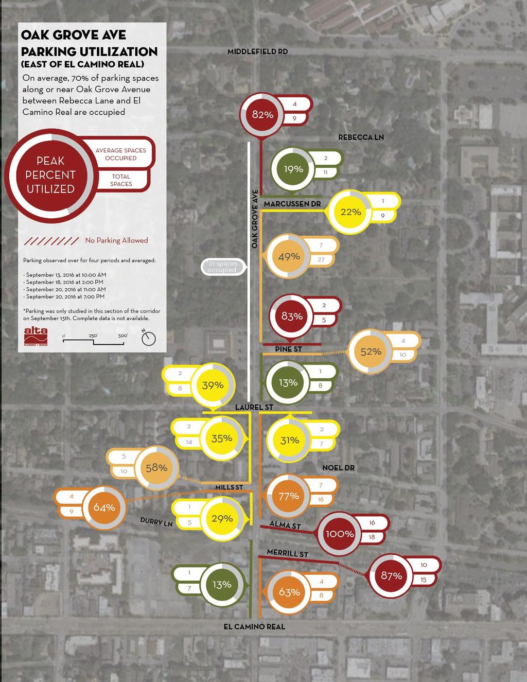
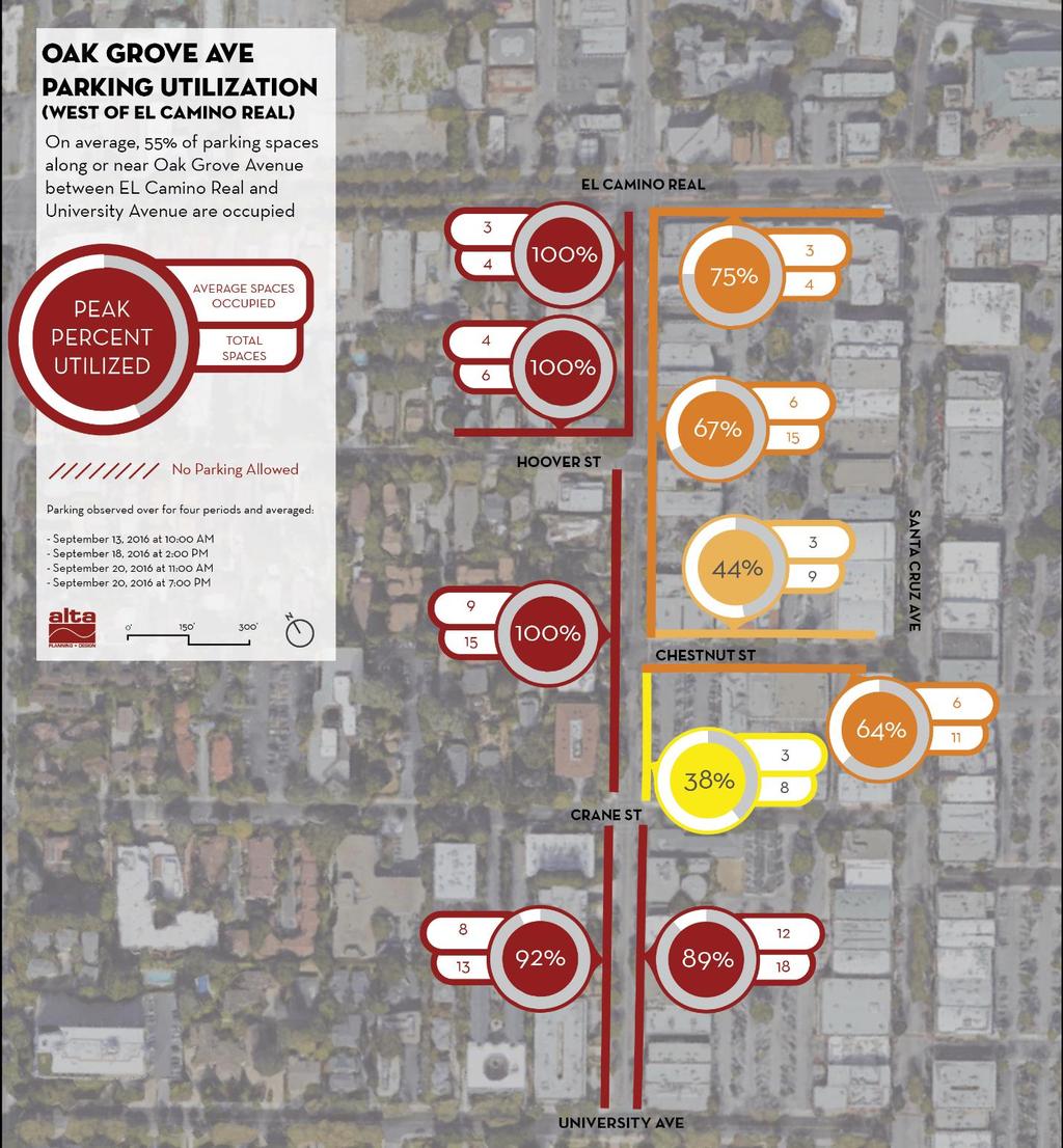
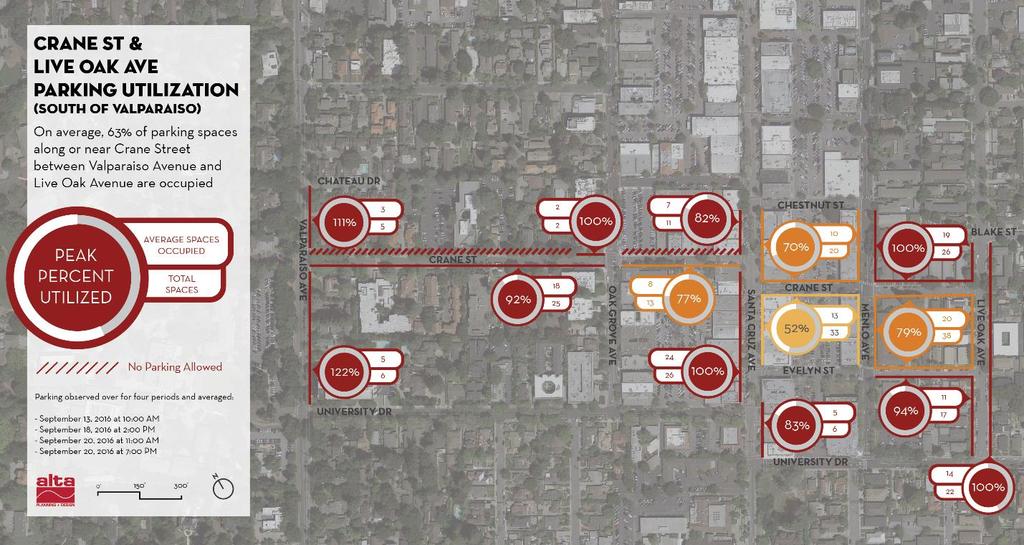
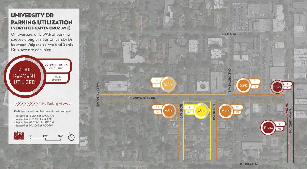
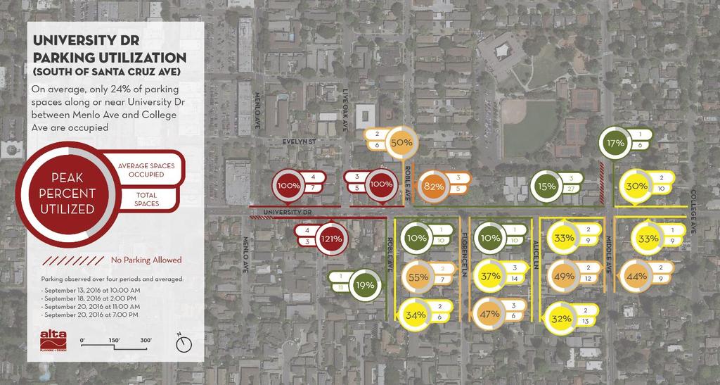
2 Staff Report #: CC distance of 1.5 miles and can be divided into four distinct sections. A map showing the proposed route is included in Attachment A. The four sections along with their unique characteristics are detailed in Table 1: Existing Conditions below. Roadway Section Table 1: Existing Conditions ADT (vpd) Speed Limit 85th% Speed Roadway Width Parking Spaces (incl. side streets) Oak Grove Ave east of El Camino 8,700-9, mph 32 mph Real Oak Grove Ave west of El Camino 7, mph 27 mph Real Crane St & Live Oak Ave 2,400-2, mph n/a University Drive 5,800-9, mph 31 mph Following City Council direction, staff retained the services of Alta Planning & Design to prepare a Bicycle Improvement Concept Plan for Oak Grove Avenue, Crane Street and University Drive. Alta prepared a comprehensive study to document existing conditions, prepare a needs assessment, and assess potential parking impacts of adding bicycle facilities to the roadway. Needs Assessment The Needs Assessment prepared by Alta is provided in Attachment B. The Circulation Element of the General Plan recognizes Menlo Park as an ideal environment for bicycling due to its mild climate, relatively flat terrain and closely spaced destinations. The roughly eight percent of residents that bike to work is thirteen times higher than the county average and indicates that bicycling is actively used by residents and comprises an important mode of transportation for the city. Oak Grove Avenue, Crane Street, and University Drive provide a direct connection to Downtown Menlo Park and also links several popular destinations including schools, job centers, parks, churches and the Caltrain station. Many residents considering alternative modes of transportation stand to benefit from the bicycle improvements including a major benefit to students travelling to Hillview Middle School, Nativity School, and Menlo-Atherton High School which feeds directly into the proposed route. As described in the National Association of City Transportation Officials (NACTO) Urban Bikeway Design Guide and allowed for use per the California Manual of Traffic Control Devices (CA-MUTCD) guidelines, a buffered bike lane is a conventional bike lane paired with a designated buffer space separating the bike lane from the adjacent vehicle lane. Buffered bike lanes provide greater shy distance between vehicles and bikes, provides space for bikes to pass other bikes, allows bikes to ride outside of the door zone of parked vehicles, and encourages bicycling. Impact Summary The available public right-of-way width is limited and in some cases, an adequate bike improvement comes in exchange of parking. In the interest of understanding this impact and estimating the average utilization of on-street parking, a robust data collection method was performed over four distinct observation periods. Observations were taken twice during a weekday between 10:00 AM- 3:00 PM to capture daytime parking needs, between 7:00 PM- 6:00 AM to capture overnight parking needs and between 2:00 PM - 6:00 PM on a weekend day. Taken in composite, the four observations reflect typical parking needs (daytime noncommuters, commuters, and weekend use) for each roadway segment. The Impact Summary was used directly to inform the development of the concept plan and is provided in Attachment B. City of Menlo Park 701 Laurel St., Menlo Park, CA tel PAGE 402
3 Staff Report #: CC Concept Plan The concept plan shown in Attachment C includes bicycle improvements in both directions along Oak Grove Avenue, Crane Street and University Drive. Staff recommends parking removal for buffered bike lane in the areas that experience low parking utilization rates while retaining existing parking spaces on side streets. Where street widths allow, parking is preserved to minimize impacts to adjacent residents or businesses along the corridor. Each section s parking utilization rates, available width and recommended actions are shown in Table 2: Concept Plan Recommendations. Roadway Section 1. Oak Grove Ave east of ECR 2. Oak Grove Ave west of ECR 3. Crane St & Live Oak Ave 4. University Drive %Spaces Utilized Table 2: Concept Plan Recommendations Available Space Recommended Action 58% Remove Parking on Both sides 72% 41 Remove Parking On North side 90% Retain existing parking 28% 34 Remove Parking on Both sides Bicycle Facility Buffered Bike Lane Buffered Bike Lane Spaces To Remove Spaces Remaining Sharrows Buffered Bike Lane Oak Grove Avenue east of ECR: The section of Oak Grove Avenue to the east of Laurel Street experiences parking demand from students from the Menlo-Atherton High School Campus that regularly intrudes into the neighborhood along Marcussen Drive. City Staff has engaged school staff to encourage students to use the parking lot on campus. Existing off-street parking along the Nativity Church property is fully utilized, will remain, and has been accounted for in Table Staff reviewed the collision history at the Oak Grove and Laurel Street intersection and found that an average of one collision per year over a 10-year period with three collisions occurring in The primary factors for the collisions were drivers running the red light or failing to yield when turning left. As a result, staff recommends all of the existing 8 signal heads to be upgraded to 12 and to convert Laurel Street signal phasing to split phase which would increase signal visibility and reduce turning conflicts. The phasing change would increase average vehicle delay at the intersection, but the overall operation would still be acceptable. This signal modification would be a permanent improvement. 2. Oak Grove Avenue west of El Camino Real: This section experiences a higher parking utilization rate, and staff recommends retaining parking on the south side of the street. The street width in this section can accommodate buffered bike lanes and hourly parking on one side for downtown businesses. The parking demand for the 25 spaces removed from the north side of the street can be accommodated by parking in the parking plazas and on the side streets. 3. Crane Street and Live Oak Avenue: This section carries the highest parking utilization rate with an average of 90% of the available parking spaces used. The high demand for parking, bike usage and low traffic volumes makes this section ideal for the installation of sharrows. 4. University Drive: This section has the lowest of utilization of on-street parking with less than 30% of the available spaces being used. The street width in this section does not allow for both bike lanes and onstreet parking. With the low demand for parking and higher traffic volumes, it is recommended to remove parking on both sides for buffered bike lanes. City of Menlo Park 701 Laurel St., Menlo Park, CA tel PAGE 403
4 Staff Report #: CC Coordination Efforts The draft concept plan was developed and coordinated with two Bike Commissioners who developed the initial concept. While the concept plan includes the crossing of El Camino Real, Caltrans has jurisdiction over the El Camino Real and Oak Grove Avenue intersection, and additional coordination and future work will still need to be performed in order to implement improvements in the Caltrans right-of-way. Oak Grove Avenue between Middlefield Road and the city limits is under the Town of Atherton jurisdiction which is considering reclassifying this section as a Class II bikeway and is currently in the design phase for pedestrian and bicycle upgrades to the Oak Grove Avenue and Middlefield Road intersection. The concept bike improvements are also consistent with the Transportation Commission s recent action on the proposed Station 1300 development. Ongoing work related to downtown parking, as also being considered by the Council on December 6, 2016, is complementary to this project and future efforts on parking permit feedback. Community Engagement City staff and the consultant team initiated two stakeholder meetings with the Nativity School & Nativity Church and the Chamber of Commerce on October 26-27, ,846 postcards were also mailed to residents, business owners, and property owners along the proposed route up to half a block away two weeks prior to the Council meeting. All of the feedback that was received is summarized in the Table 3: Community Feedback. As of December 1, 14 phone calls or s were received in response to the postcard mailers. The feedback was used in the development of the concept plan and furthermore, identified operational issues that will be addressed in the final design. Nativity School Nativity School Table 3: Community Feedback Source Location Concern Recommendation Oak Grove Ave and Laurel St Oak Grove Ave east of Laurel St Collisions at the signalized intersection of Oak Grove Avenue and Laurel St Large parking demands during seasonal major events such as the Carnival Fire District Crane St Existing narrow sections of Crane Street present challenges for large service vehicles and emergency access Chamber of Commerce Marcussen Drive Residents Oak Grove Ave east of Laurel St Marcussen Dr Parking intrusion on Oak Grove from Menlo-Atherton High School Parking Intrusion from Menlo- Atherton High School -Upgrade all 8 signal heads to 12 signal heads -Convert Laurel Street to split phase operation -Enhanced green lane treatments and bike boxes -Would be a permanent change Consider operational adjustments during the final design phase, such as allowing parking in the bike lanes for the weekend of the Carnival Consider parking removal in some areas on one side of Crane to improve access for large vehicles -Engaged High School staff to encourage students to park on campus instead of residential streets. -Consider lengthening time restrictions or parking permits -Engaged High School staff to encourage students to park on campus instead of residential streets. -Consider operational lengthening time restrictions or parking permits City of Menlo Park 701 Laurel St., Menlo Park, CA tel PAGE 404
5 Staff Report #: CC University Drive Residents Table 3: Community Feedback Source Location Concern Recommendation University Dr All-day parking from downtown has spread to the neighborhood side streets and will become worse if parking is removed from University Dr Oak Grove Avenue Residents Crane Street Businesses Oak Grove Ave and Alma St Crane Street and Parking Plazas Visitors, service and delivery vehicles need parking spaces along Oak Grove Businesses need more options for employee parking Ongoing consideration for adjustments to existing all-day parking restrictions and downtown permits such as transferable permits, pricing tier system for permits, expansion of all day parking options to all remaining plazas, and new parking machine technology to encourage use of parking plazas for all-day parking through Downtown Parking program Visitors, service and delivery vehicles will have to park on the closest side street Ongoing consideration for adjustments to existing all-day parking restrictions and downtown permits such as transferable permits, pricing tier system for permits, expansion of all day parking options to all remaining plazas, and new parking machine technology to encourage use of parking plazas for all-day parking through Downtown Parking program Next Steps Following City Council review and approval, future tasks are anticipated to include preparation of final design plans sufficient for a contractor to build, awarding a construction contract, and construction as described below. On this schedule, staff anticipates that weather-pending, the project could be operational by spring 2017, in time for Bike Month (May) events such as Bike to Work Day. Once implemented, the bike improvements will be evaluated over a one-year period analyzing criteria such as bike ridership, travel times, vehicle speeds, and overall comfort of the corridor. Community feedback regarding downtown parking restrictions and permits will be evaluated through ongoing work on the Downtown Parking program, continuing in early Other potential operational issues raised if the project is constructed would continue to be evaluated and responded to on an ongoing basis during the trial. Table 4: Proposed Project Schedule Task Schedule 1 Council Review December Prepare Design Plans December January Award Construction Contract February Construction March April Facility Opens May Pilot Evaluation May 2018 Impact on City Resources The City s Fiscal Year adopted budget includes staff time for review and inspections, but does not include funding for improving pedestrian and bike amenities along the proposed route. The estimated cost City of Menlo Park 701 Laurel St., Menlo Park, CA tel PAGE 405
6 Staff Report #: CC to prepare a detailed engineering level design, construct a one-year pilot, and install signal improvements at Laurel Street & Oak Grove Avenue is shown in Table 5: Cost Estimates below. Completion of final design plans would provide engineering drawings sufficient for a contractor to bid the project and includes a $10,000 contingency. Construction costs include the removal of existing striping, replacement of proposed striping, signs, traffic control and contingency. The proposed signal modification at Laurel Street and Oak Grove Avenue would be a permanent change to upgrade the signal equipment to improve visibility and safety. Table 5: Cost Estimates Task Cost Final Design (incl. $10,000 contingency) $56,000 Construction (incl. 25% contingency) $142,000 Laurel St & Oak Grove Signal Improvements $38,200 Total $236,200 Several funding sources for the proposed project were explored, including the Transportation Impact Fee Program (TIF), the El Camino Real/Downtown Specific Plan Area Supplemental Transportation Impact Fee, grant programs and the General Fund. The TIF and Supplemental TIF programs did not collect funds towards the proposed project, so are not potential funding sources. Competitive grant funds are potentially available in the next few years, but would not allow construction to occur on the proposed schedule. Therefore, funds from the General Fund are proposed for completion of this project. Since the construction bids received for the Santa Cruz Avenue Sidewalk project were lower than the budgeted amount, this resulting savings could be repurposed for this project. Staff is requesting that an appropriation of $236,200 from the undesignated fund balance of the General Fund to complete this project. Environmental Review The recommendation is categorically exempt under Class 1 (Existing Conditions) and Class 4 (Minor Modifications) of the current State of California Environmental Quality Act Guidelines. Public Notice Public Notification was achieved by posting the agenda, with the agenda items being listed, at least 72 hours prior to the meeting. Postcard notices of the council meeting were also sent to residents, property and business owners that are located on the route. Attachments A. Proposed Bicycle Route B. Impact Summary C. Concept Plans Report prepared by: Michael Tsai, Assistant Engineer Report reviewed by: Kristiann Choy, Senior Transportation Engineer Nicole H. Nagaya, Transportation Manager City of Menlo Park 701 Laurel St., Menlo Park, CA tel PAGE 406
7 University Dr Crane St El Camino Real Laurel St Map of Project Extents ATTACHMENT A ± ATHERTON Oak Grove Ave Middlefield Rd Santa Cruz Ave Menlo Ave Ravenswood Ave Live Oak Ave Middle Ave Proposed Bicycle Route PBR in Town of Atherton PAGE 407 City Limits
8 THIS PAGE INTENTIONALLY LEFT BLANK PAGE 408
9 ATTACHMENT B o o o o o PAGE 409
10 o o o o o o o PAGE 410
11 PAGE 411


12 o PAGE 412
13 o o PAGE 413
14 PAGE 414
15 PAGE 415
16 PAGE 416
17 PAGE 417
18 PAGE 418


19 PAGE 419
20 PAGE 420


21 PAGE 421


22 PAGE 422


23 PAGE 423
24 PAGE 424
25 PAGE 425
26 PAGE 426
27 PAGE 427
28 PAGE 428


29 OAK GROVE AVENUE ATTACHMENT C Sheet No. 1 of 6 38' 6' BIKE LANE Scale: 1" = 100' ' RIGHT TURN LANE CITY OF MENLO PARK 6' THROUGH BIKE LANE MATCHLINE: SEE SHEET 2 10' 10' CITY LIMIT LINE EXISTING CROSSWALK A A' BEGIN BIKE LANE SIGN 6' END BIKE LANE SIGN PAGE 429 TRAVEL LANE TRAVEL LANE BIKE LANE SHEET 3 SHEET 2 SHEET 1 SHEET 3 SHEET 2 SHEET 1 3' BUFFER 3' BUFFER SHEET 4 38' SECTION A - A' SHEET 5 SHEET 5 SHEET 6 SHEET 6 KEY MAP Oak Grove Avenue, Crane Street, University Drive Bicycle Improvement Project Menlo Park, CA


 10' RIGHT TURN LANE")


30 MATCHLINE: SEE SHEET 1 6' BIKE LANE 10' TRAVEL LANE 3' BUFFER 10' TRAVEL LANE 45' 6' BIKE LANE 10' RIGHT TURN LANE OAK GROVE AVENUE 41' 6' 11.5' 11.5' 6' SHEET 3 SHEET 2 SHEET 1 BIKE LANE TRAVEL LANE TRAVEL LANE Scale: 1" = 100' CITY OF MENLO PARK Sheet No. MATCHLINE: SEE SHEET 3 BIKE LANE 2 3' BUFFER of 6 EXISTING CROSSWALK EXISTING CROSSWALK BIKE BOXES AND THRU-INTERSECTION MARKINGS (TYP) 10' RIGHT TURN LANE EXISTING CROSSWALK SECTION B - B' B B' C C' 6' THROUGH BIKE LANE SHEET 3 SHEET 2 SHEET 1 3' BUFFER SHEET 4 41' SHEET 5 SHEET 5 SECTION C - C' SHEET 6 SHEET 6 KEY MAP Oak Grove Avenue, Crane Street, University Drive Bicycle Improvement Project Menlo Park, CA PAGE 430

")


31 OR ZONE 39' E CALTRANS ROW DOOR Z MATCHLINE: SEE SHEET 2 51' 52' 35' 41' 41' 29' EXISTING CROSSWALK 6' THROUGH BIKE LANE "" MARKING (TYP) EXISTING CROSSWALK D D' EXISTING CROSSWALK MATCHLINE: SEE SHEET 4 5' BIKE LANE 10' 10' TRAVEL LANE TRAVEL LANE 1.5' BUFFER 41' 5' BIKE LANE 8' PARKING 1.5' BUFFER Scale: 1" = 100' SHEET 3 SHEET 2 SHEET 1 SECTION D - D' SHEET 5 SHEET 6 Oak Grove Avenue, Crane Street, University Drive Bicycle Improvement Project Menlo Park, CA EXISTING CROSSWALK 6' THROUGH BIKE LANE CITY OF MENLO PARK Sheet No. 3 of 6 SHEET 3 SHEET 2 SHEET 1 SHEET 4 SHEET 5 SHEET 6 KEY MAP CONSIDER THRU-INTERSECTION MARKINGS (CALTRANS COORDINATION REQUIRED) PAGE 431
")

 E F MATCHLINE: SEE SHEET 3")


32 41' 39' 41' 41' 29' 29' 29' 35' CRANE STREET 150' SPACING (TYP) OAK GROVE AVENUE VALPARAISO AVENUE MATCHLINE: SEE SHEET 5 STAGGERED SHARED LANE MARKINGS (TYP) E F MATCHLINE: SEE SHEET 3 EXISTING CROSSWALK E WAYFINDING SIGNAGE CITY BOUNDARY "" MARKING (TYP) E' F' EXISTING CROSSWALK E' 5.5' 11' 11' 7' TRAVEL LANE W/ SHARROWS TRAVEL LANE W/ SHARROWS 29' 12.5' PARKING 7' 14' 14' 7' TRAVEL LANE W/ SHARROWS TRAVEL LANE W/ SHARROWS 35' 14' PARKING SHEET 3 SHEET 2 SHEET 1 SECTION E - E' SECTION F - F' SHEET 5 SHEET 6 Oak Grove Avenue, Crane Street, University Drive Bicycle Improvement Project Scale: 1" = 100' Menlo Park, CA CITY OF MENLO PARK Sheet No. 4 of 6 SHEET 3 SHEET 2 SHEET 1 SHEET 4 SHEET 5 SHEET 6 KEY MAP PAGE 432


 NEW STOP SIGNS G NEW STOP SIGN G' EXISTING")


 MODIFIED LEFT TURN")
33 E' EXISTING CROSSWALKS WAYFINDING SIGNAGE 29' WAYFINDING SIGNAGE WAYFINDING SIGNAGE CRANE STREET E MATCHLINE: SEE SHEET 6 33' 29' 11.75' 11.75' 9.5' 9.5' 7' 7' PARKING TRAVEL LANE W/ SHARROWS TRAVEL LANE W/ SHARROWS PARKING CRANE STREET 33' Sheet No. 5.5' 11' 11' 7' TRAVEL LANE W/ SHARROWS TRAVEL LANE W/ SHARROWS 29' 12.5' PARKING 5 CITY OF MENLO PARK Scale: 1" = 100' SANTA CRUZ AVENUE MATCHLINE: SEE SHEET 4 SECTION E - E' E E' WAYFINDING SIGNAGE MODIFIED LEFT TURN SHARED LANE MARKING FUTURE PARKLET (NOT A PART OF THIS PROJECT) NEW STOP SIGNS G NEW STOP SIGN G' EXISTING CROSSWALKS NEW STOP SIGN SHEET 3 SHEET 2 SHEET 1 12' 16.5' 16.5' 10' SHEET 5 BUS STOP TRAVEL LANE TRAVEL LANE PARKING 55' SHEET 6 Menlo Park, CA Oak Grove Avenue, Crane Street, University Drive Bicycle Improvement Project of 6 KEEP CLEAR INTERSECTION MARKINGS WAYFINDING SIGNAGE EXISTING CROSSWALKS NEW STOP SIGN "" MARKINGS (TYP) STAGGERED SHARED LANE MARKINGS (TYP) MODIFIED LEFT TURN SHARED LANE MARKING WAYFINDING SIGNAGE SECTION H - H' H H' SHEET 3 SHEET 2 SHEET 1 SHEET 4 SHEET 5 SECTION G - G' SHEET 6 KEY MAP PAGE 433

 MODIFIED LEFT TURN")


34 I MATCHLINE: SEE SHEET 5 I' 42' OAK LANE ROBLE AVENUE 34' 35' FLORENCE LANE 35' ROBLE AVENUE WAYFINDING SIGNAGE "" MARKINGS (TYP) STAGGERED SHARED LANE MARKINGS (TYP) MODIFIED LEFT TURN SHARED LANE MARKING END BIKE LANE SIGN J WAYFINDING SIGNAGE EXISTING CROSSWALKS BEGIN BIKE LANE SIGN J' SHEET 3 SHEET 2 SHEET 1 8' PARKING 14.5' 14.5' 13' 13' TRAVEL LANE W/ SHARROWS 42' TRAVEL LANE W/ SHARROWS 8' PARKING 5' 10' 10' 5' BIKE TRAVEL LANE TRAVEL LANE LANE 2' BUFFER 2' BUFFER 34' BIKE LANE Scale: 1" = 100' SHEET 5 SHEET 6 Oak Grove Avenue, Crane Street, University Drive Bicycle Improvement Project Menlo Park, CA WAYFINDING SIGNAGE CITY OF MENLO PARK Sheet No. 6 of 6 SHEET 3 SHEET 2 SHEET 1 SHEET 4 SHEET 5 SECTION I - I' SECTION J - J' SHEET 6 KEY MAP BEGIN BIKE LANE SIGN PAGE 434
Item No. 14 Town of Atherton
 Item No. 14 Town of Atherton CITY COUNCIL STAFF REPORT CONSENT AGENDA TO: THROUGH: FROM: HONORABLE MAYOR AND CITY COUNCIL GEORGE RODERICKS, CITY MANAGER MICHAEL KASHIWAGI, COMMUNITY SERVICES DIRECTOR MARTY
AGENDA ITEM H-1 Public Works
 AGENDA ITEM H-1 Public Works STAFF REPRT City Council Meeting Date: 11/13/2018 Staff Report Number: 18-208-CC Regular Business: Adopt Resolution No. 6470 to approve the permanent installation of bicycle
TRANSPORTATION MASTER PLAN Review Citywide Recommendations, Updated List and Scoring Methodology December 6, 2018
 NOTE: Due to lengthy Committee discussion and allotted meeting time, slides 12-35 were not presented at the meeting, but are provided here for reference. TRANSPORTATION MASTER PLAN Review Citywide Recommendations,
CITY OF LOS ANGELES INTER-DEPARTMENTAL MEMORANDUM
 CITY OF LOS ANGELES INTER-DEPARTMENTAL MEMORANDUM Date: April 1, 219 To: Honorable City Council c/o City Clerk, Room 395, City Hall Attention: Honorable Mike Bonin, Chair, Transportation Committee From:
Recommendations For Oak Grove Bike Project Field Trial
 Purpose: It is not easy to make decisions that require trade-offs between competing interests, what the Menlo Park City Council now faces, as it considers a field trial to evaluate the Oak Grove- Crane-University
2014/2015 BIKE ROUTE PLAN 83 AVENUE PROTECTED BIKE LANE
 About the Project 2014/2015 BIKE ROUTE PLAN The City of Edmonton is planning a major bike route on the south side of Edmonton. This bike route is one part of a plan to provide citizens with transportation
EUCLID AVENUE PARKING STUDY CITY OF SYRACUSE, ONONDAGA COUNTY, NEW YORK
 EUCLID AVENUE PARKING STUDY CITY OF SYRACUSE, ONONDAGA COUNTY, NEW YORK CITY OF SYRACUSE DEPARTMENT OF PUBLIC WORKS 1200 CANAL STREET EXTENSION SYRACUSE, NEW YORK 13210 DRAFT REPORT DATE: November 13,
El Camino Real Specific Plan. TAC/CAC Meeting #2 Aug 1, 2018
 El Camino Real Specific Plan TAC/CAC Meeting #2 Aug 1, 2018 Land Use Alternatives Goals and Tradeoffs Parks & open space Housing Retail & services Civic spaces Parking Community gathering spaces 3 Alternatives
TRAFFIC ACTION PLAN. Laurie Meadows Neighborhood CITY OF SAN MATEO
 TRAFFIC ACTION PLAN Laurie Meadows Neighborhood CITY OF SAN MATEO Draft January 2017 Table of Contents Introduction... 2 The Traffic Forum Process... 5 Neighborhood Traffic Issues... 7 Neighborhood Recommendations
2014/2015 BIKE ROUTE PLAN 83 AVENUE PROTECTED BIKE LANE
 About the Project The City of Edmonton is planning a major bike route on the southside of Edmonton. The Strathcona Bike Route will connect the communities of Strathcona, Garneau and the University area,
Anholm Bikeway Plan Planning Commission Meeting Summary (8/14/18)
") Anholm Bikeway Plan Planning Commission Meeting Summary (8/14/18) Overview: On August 14, 2018, the Planning Commission considered plans for the middle section of the Anholm Bikeway Plan, focusing on the
Anholm Bikeway Plan Planning Commission Meeting Summary (8/14/18) Overview: On August 14, 2018, the Planning Commission considered plans for the middle section of the Anholm Bikeway Plan, focusing on the
TRAFFIC IMPACT STUDY CRITERIA
 Chapter 6 - TRAFFIC IMPACT STUDY CRITERIA 6.1 GENERAL PROVISIONS 6.1.1. Purpose: The purpose of this document is to outline a standard format for preparing a traffic impact study in the City of Steamboat
Public Works AGENDA ITEM D-2 STAFF REPORT
 AGENDA ITEM D-2 Public Works STAFF REPORT Transportation Master Plan Oversight and Outreach Committee Meeting Date: 10/30/2017 Staff Report Number: 17-001-TMP Regular Business: Provide feedback on Performance
Exhibit 1 PLANNING COMMISSION AGENDA ITEM
 Exhibit 1 PLANNING COMMISSION AGENDA ITEM Project Name: Grand Junction Circulation Plan Grand Junction Complete Streets Policy Applicant: City of Grand Junction Representative: David Thornton Address:
MEMORANDUM. Sutter Street Bicycle Lanes, Stockton, CA SF
 MEMORANDUM Date: To: From: Subject: PURPOSE Anthony J. Lopes, Siegfried Engineering Christine Carey & Matthew Ridgway, Fehr & Peers Sutter Street Bicycle Lanes, Stockton, CA SF09-0468 The City of Stockton
B. TRANSPORTATION, CIRCULATION AND PARKING
 FEBRUARY 0 89 EL CAMINO REAL PROJECT EIR This section describes the existing traffic, circulation, parking, and transit conditions in the vicinity of the project site and provides an analysis of the project
City of Memphis On-Street Parking Modification Guidelines
 City of Memphis Effective Date: December 1, 2013 Bicycle/Pedestrian Program 125 N. Main Street Memphis, TN 38103 (901) 576-6710 www.bikepedmemphis.com City of Memphis Executive Summary It is current practice
APPENDIX A: Complete Streets Checklist DRAFT NOVEMBER 2016
 APPENDIX A: Complete Streets Checklist DRAFT NOVEMBER 2016 Complete Streets Checklist MetroPlan Orlando s Complete Streets Checklist is an internal planning tool for staff to further implementation of
Subject: Bike Project Field Trial Must Validate Bike Safety Claims
 April 12, 2017 To: Menlo Park City Council Subject: Bike Project Field Trial Must Validate Bike Safety Claims A few weeks ago, a collision between my road bike and a white pick-up truck on Woodside Road
University of Victoria Campus Cycling Plan Terms of Reference. 1.0 Project Description
 University of Victoria Campus Cycling Plan Terms of Reference 1.0 Project Description The Campus Cycling Plan, a first for the University, will provide a comprehensive and coordinated approach to support
COMMUNITY MEETING AGENDA
 COMMUNITY MEETING AGENDA Welcome and Introductions SAFE Presentation Project Presentation Priorities Feedback Next Steps Q&A Santa Cruz Avenue Corridor Study 1 Santa Cruz Avenue Corridor Study Community
Cycle Track Design Best Practices Cycle Track Sections
 Design Best Practices Sections It is along street segments where the separation and protection methods of cycle tracks offer more comfort than conventional bicycle lanes, and are more attractive to a wide
Caltrans Sloat Boulevard Pedestrian Safety Project Response to Community Questions, Comments & Concerns
 Caltrans Sloat Boulevard Pedestrian Safety Project Response to Community Questions, Comments & Concerns Revised: May 10, 2016 The California Department of Transportation (Caltrans) is planning various
WALKNBIKE DRAFT PLAN NASHVILLE, TENNESSEE EXECUTIVE SUMMARY NASHVILLE, TENNESSEE
 NASHVILLE, TENNESSEE EXECUTIVE SUMMARY Executive Summary A world-class multi-modal transportation system is essential to a vibrant city and better quality of life. -Mayor Barry The WalknBike plan aims
AGENDA ITEM H-3 Public Works
 AGENDA ITEM H-3 Public Works STAFF REPORT City Council Meeting Date: 5/3/2016 Staff Report Number: 16-074-CC Consent Calendar: Adopt a resolution authorizing the installation of stop signs on Chilco Street
San Mateo County Bicycle and Pedestrian Advisory Committee
 San Mateo County Bicycle and Pedestrian Advisory Committee January 19, 2017 Emma Shlaes, Policy Manager About SVBC Mission Our purpose is to create a healthy community, environment, and economy through
REVIEW OF LOCAL TRAFFIC FLOW / LONG RANGE PLANNING SOLUTIONS STUDY
 ITEM Town of Atherton TRANSPORTATION COMMITTEE STAFF REPORT TO: FROM: MEMBERS OF THE COMMITTEE ROBERT OVADIA, PUBLIC WORKS DIRECTOR DATE: FEBRUARY 12, 2019 SUBJECT: REVIEW OF LOCAL TRAFFIC FLOW / LONG
City of San Diego Vision Zero Draft Strategic Plan FY 2017
 City of San Diego Vision Zero Draft Strategic Plan FY 2017 Engineering Objective: To develop and implement a strategy that employs best planning, design and engineering practices. Background: Over the
Pedestrian Project List and Prioritization
 To: Kyle Wagenschutz, City of Memphis CC: From: Anne Conlon and John Cock, Alta Planning + Design Date: December, 2014 Re: Project List Development (Task 3.1-3.2) and Project List Prioritization (Task
PRINCE GEORGE S PLAZA METRO AREA PEDESTRIAN PLAN
 PRINCE GEORGE S PLAZA METRO AREA PEDESTRIAN PLAN May 28, 2008 Agenda Welcome and introductions Project overview and issue identification Planning context and strengths Design challenges and initial recommendations
Welcome! San Jose Avenue Open House August 25, 2015
 Welcome! San Jose Avenue Open House August 25, 2015 Vision Zero The City and County of San Francisco adopted Vision Zero San Francisco Vision Zero High Injury Network as a policy in 2014, committing an
Omaha s Complete Streets Policy
 Omaha s Complete Streets Policy (Adopted August 2015) VISION To create great places and enhance our quality of life, the City of Omaha will provide safe, accessible streets for all users. Complete Streets
TOWN OF CHAPEL HILL POLICY AND PROCEDURES FOR TRAFFIC CALMING MEASURES
 TOWN OF CHAPEL HILL POLICY AND PROCEDURES FOR TRAFFIC CALMING MEASURES (Adopted by the Town Council on June 30, 2004) (Revised December 6, 2010) (Revised February 8, 2016) POLICY AND PROCEDURES FOR TRAFFIC
Harbord Street and Hoskin Avenue Bicycle Lane Upgrades
 STAFF REPORT ACTION REQUIRED and Bicycle Lane Upgrades Date: April 22, 2014 To: From: Wards: Reference Number: Public Works and Infrastructure Committee General Manager, Transportation Services 19 and
Governance and Priorities Committee Report For the July 2, 2015 Meeting
 CITY OF VICTORIA For the July 2, 2015 Meeting To: Governance and Priorities Committee Date: From: Subject: Brad Dellebuur, A/Assistant Director, Transportation and Parking Services Executive Summary The
This page intentionally left blank.
 This page intentionally left blank. COMMUNITY Coweta Community Overview Coweta Coweta, a residential community located in Wagoner County, is a suburb of Tulsa situated southeast of the metropolitan area
122 Avenue: 107 Street to Fort Road
 : 107 Street to Fort Road November 24, 2015 4:30 8:00 p.m. Meeting Purpose Summarize project work completed to date Share results of public input from Phase 1 Share the draft concept plan and proposed
Dr. M.L. King, Jr. Street North Complete Streets Resurfacing Opportunities HOUSING, LAND USE, AND TRANSPORTATION COMMITTEE MARCH 22, 2018
 Dr. M.L. King, Jr. Street North Complete Streets Resurfacing Opportunities HOUSING, LAND USE, AND TRANSPORTATION COMMITTEE MARCH 22, 2018 What s Happening The City plans to mill and resurface Dr. M.L.
Agenda. Overview PRINCE GEORGE S PLAZA METRO AREA PEDESTRIAN PLAN
 PRINCE GEORGE S PLAZA METRO AREA PEDESTRIAN PLAN May 28, 2008 Agenda Welcome and introductions Project overview and issue identification Planning context and strengths Design challenges and initial recommendations
Public Works Committee Meeting Richard E. Mastrangelo Council Chamber November 20, 2017
 Public Works Committee Meeting Richard E. Mastrangelo Council Chamber November 20, 2017 Purpose of Meeting Why are we here? Project Recap/Updates Project Limits/Segments Road Diet Concept Lessons Learned
SUBJECT Memorandum of Understanding to Complete a Caltrain Grade Separation Study for the Whipple Avenue Crossing
 REPORT To the Honorable Mayor and City Council From the City Manager October 1, 2018 SUBJECT Memorandum of Understanding to Complete a Caltrain Grade Separation Study for the Whipple Avenue Crossing RECOMMENDATION
Complete Street Analysis of a Road Diet: Orange Grove Boulevard, Pasadena, CA
 Complete Street Analysis of a Road Diet: Orange Grove Boulevard, Pasadena, CA Aaron Elias, Bill Cisco Abstract As part of evaluating the feasibility of a road diet on Orange Grove Boulevard in Pasadena,
TRAFFIC ACTION PLAN. North Central Neighborhood CITY OF SAN MATEO
 TRAFFIC ACTION PLAN North Central Neighborhood CITY OF SAN MATEO Draft February 2017 Table of Contents Introduction... 1 The Traffic Forum Process... 4 Neighborhood Traffic Issues... 6 Neighborhood Recommendations
TABLE OF CONTENTS. Executive Summary
 Executive Summary Background... ES-1 Pedestrian Network... ES-2 Bikeway Network... ES-2 Collision History... ES-2 Public Input... ES-4 Conclusions and Recommendations... ES-4 1. Introduction and Setting
Living Streets Policy
 Living Streets Policy Introduction Living streets balance the needs of motorists, bicyclists, pedestrians and transit riders in ways that promote safety and convenience, enhance community identity, create
Report. Typical Sections. City of Middleton, WI
 Report Typical Sections City of Middleton, WI December 2006 Report for City of Middleton, Wisconsin Typical Sections repared by: Traffic Associates LLC and STRAND ASSOCIATES, INC. 910 West Wingra Drive
Bellevue Downtown Association Downtown Bike Series
 Bellevue Downtown Association Downtown Bike Series Meeting 2 Franz Loewenherz Andreas Piller Kyle Potuzak Chris Long October 26, 2017 Today s Agenda: 1) Meeting Purpose 2) 9/28 Meeting Recap 3) Candidate
City of Charlottesville Bicycle and Pedestrian Master Plan Update
 City of Charlottesville Bicycle and Pedestrian Master Plan Update September 17, 2014 I. Welcome and meeting overview II. Project status update III. Network overview IV. Break-out groups Pedestrian Network
Commerce Street Complete Street Project from Good Latimer Expressway to Exposition Avenue
 Commerce Street Complete Street Project from Good Latimer Expressway to Exposition Avenue T A N Y A B R O O K S A S S I S T A N T D I R E C T O R M O B I L I T Y P L A N N I N G M O B I L I T Y A N D S
CITY OF OTTAWA ROADWAY MODIFICATION APPROVAL UNDER DELEGATED AUTHORITY
 RMA-2015-ATM-038 CITY OF OTTAWA ROADWAY MODIFICATION APPROVAL UNDER DELEGATED AUTHORITY DATE: April 22, 2015 SUBJECT Approval of Roadway Modifications Recommended through an Area Traffic Management Study
Telegraph Avenue Complete Streets DRAFT Recommendations. Oakland Public Works Department September 11 and 13, 2014 Open Houses
 Telegraph Avenue Complete Streets DRAFT Recommendations Oakland Public Works Department September 11 and 13, 2014 Open Houses Presentation Overview What are complete streets? What problem are we trying
Northbound San Jose Avenue & I-280 Off-Ramp Road Diet Pilot Project
 Project Overview Fed by a two-lane Interstate-280 (I-280) off-ramp, high vehicular volumes and speeds are longstanding issues along San Jose Avenue. Residents in the surrounding neighborhoods have expressed
Lessons Learned from Cycle Tracks (Class IV Bikeways) Design Practice
 Design Practice") Lessons Learned from Cycle Tracks (Class IV Bikeways) Design Practice By: Min Zhou, P.E., Principal/Vice President KOA Corporation 1 What is a Cycle Track (Class IV) TYPICAL BIKEWAY CLASSIFICATION CLASS
Lessons Learned from Cycle Tracks (Class IV Bikeways) Design Practice By: Min Zhou, P.E., Principal/Vice President KOA Corporation 1 What is a Cycle Track (Class IV) TYPICAL BIKEWAY CLASSIFICATION CLASS
FEDERAL HIGHWAY ADMINISTRATION APPLICATION
 FEDERAL HIGHWAY ADMINISTRATION APPLICATION REQUEST FOR PERMISSION TO EXPERIMENT WITH A BICYCLE BOX INTERSECTION TREATMENT Submitted by: City of Columbus Department of Public Service Date: June 26, 2009
Bicycle Master Plan Goals, Strategies, and Policies
 Bicycle Master Plan Goals, Strategies, and Policies Mobilizing 5 This chapter outlines the overarching goals, action statements, and action items Long Beach will take in order to achieve its vision of
9/25/2018. Multi-Modal Level of Service (MMLOS) Bianca Popescu, Transportation Planner
 Bianca Popescu, Transportation Planner") Multi-Modal Level of Service (MMLOS) Bianca Popescu, Transportation Planner 1 What is MMLOS? Is this a nice place to walk? Is this a nice place to bike? Is transit convenient? Bottom line - Are there options
Multi-Modal Level of Service (MMLOS) Bianca Popescu, Transportation Planner 1 What is MMLOS? Is this a nice place to walk? Is this a nice place to bike? Is transit convenient? Bottom line - Are there options
PEDESTRIAN ACTION PLAN
 ATTACHMENT 2 CITY OF SANTA MONICA PEDESTRIAN ACTION PLAN CITY OF SANTA MONICA PEDESTRIAN ACTION PLAN This page intentionally left blank EXECUTIVE SUMMARY CHAPTER 1 EXECUTIVE SUMMARY Setting the Stage
In station areas, new pedestrian links can increase network connectivity and provide direct access to stations.
 The Last Mile Planning for Pedestrians Planning around stations will put pedestrians first. Making walking to stations safe and easy is important; walking will be a part of every rapid transit Accessible
» Draft Recommendations» Discussion» Next Steps. Plan for Walking and Biking
 SAC Meeting Plan #3 for September Walking and 12, Biking 2018 » Draft Recommendations» Discussion» Next Steps Plan for Walking and Biking » Stakeholder and Public Outreach» Background data collection and
Outer Cape Bicycle & Pedestrian Master Plan. PUBLIC WORKSHOP #2 March 26, 2015
 Outer Cape Bicycle & Pedestrian Master Plan PUBLIC WORKSHOP #2 March 26, 2015 Introductions TODAY S DISCUSSION PRESENTATION: Project Background : Where have we been? Where are we now? Steering Committee
Lincoln Avenue Road Diet Trial
 Lincoln Avenue Road Diet Trial Data Collection Report June 1, 2015 Department of Transportation Table of Contents I. Introduction...... 3 II. Data Collection Methodology & Results...... 5 A. Traffic Volume
Corpus Christi Metropolitan Transportation Plan Fiscal Year Introduction:
 Introduction: The Safe, Accountable, Flexible, Efficient Transportation Equity Act: A Legacy for Users (SAFETEA-LU) has continued the efforts started through the Intermodal Surface Transportation Efficiency
Ann Arbor Downtown Street Plan
 1 Ann Arbor Downtown Street Plan Public Workshop #1 We know that. 2 Public right-of-way (streets, sidewalks, and alleys) make up 30% of the total District area of downtown. Streets need to provide mobility
NJDOT Complete Streets Checklist
 Background The New Jersey Department of Transportation s Complete Streets Policy promotes a comprehensive, integrated, connected multi-modal network by providing connections to bicycling and walking trip
Public Works and Infrastructure Committee. General Manager, Transportation Services. P:\2016\Cluster B\TRA\TIM\pw16009tim.docx
 Ten Year Cycling Network Plan Date: May 3, 2016 STAFF REPORT ACTION REQUIRED PW13.11 To: From: Wards: Reference Number: Public Works and Infrastructure Committee General Manager, Transportation Services
Circulation in Elk Grove includes: Motor vehicles, including cars and trucks
 Circulation, as it is used in this General Plan, refers to the many ways people and goods move from place to place in Elk Grove and the region. Circulation in Elk Grove includes: Motor vehicles, including
Transportation Policy Manual
 March 4, 2013 EXHIBIT 2 Metropolitan Transportation Planning Organization for the Gainesville Urbanized Area A Comprehensive Guide to Adopted Metropolitan Transportation Planning Organization for the
Water Street Promenade Engineering and Design Services
 Preliminary Design Presentation Parking & Traffic Safety Committee Water Street Promenade Engineering and Design Services July 16,2014 November 3, 2016 Education / Infrastructure / Innovation 1 Project
TRANSPORTATION & MOBILITY
 TRANSPORTATION & MOBILITY ROADWAY SYSTEM There are approximately 40 miles of roadways in Manitou Springs. For planning purposes, roadways are typically assigned a functional classification which defines
WELCOME. Thank you for joining us at the Second Public Workshop for the Carlsbad Pedestrian Master Plan. We look forward to receiving your feedback.
 City of Carlsbad Pedestrian Master Plan: WELCOME WELCOME Please Sign In Provide Input at Flip Charts Review Boards Presentation of Draft Plan Thank you for joining us at the Second Public Workshop for
City of Seattle Edward B. Murray, Mayor
 City of Seattle Edward B. Murray, Mayor Department of Transportation Scott Kubly, Director Eastlake Community Council 117 E Louisa St. #1 Seattle, WA 98102-3278 January 28, 2016 RE: Roosevelt to Downtown
Chair and Members of Transportation Standing Committee. Bruce Zvaniga, P.Eng., Director, Transportation and Public Works
 P.O. Box 1749 Halifax, Nova Scotia B3J 3A5 Canada Item No. 12.1.1 Transportation Standing Committee December 7, 2017 TO: Chair and Members of Transportation Standing Committee SUBMITTED BY: ORIGINAL SIGNED
Protected Bike Lanes in San Francisco Mike Sallaberry SFMTA NACTO Workshop - Chicago IL
 Protected Bike Lanes in San Francisco Mike Sallaberry SFMTA 10 14 2011 NACTO Workshop - Chicago IL San Francisco 2 nd Highest Density in the U.S. 47 square miles Mild Climate Market Population ~810,000
SR-203 Sidewalks and Town-Wide Mobility Improvements. Town Council Presentation September 7, 2016
 SR-203 Sidewalks and Town-Wide Mobility Improvements Town Council Presentation September 7, 2016 SR-203 Sidewalks and Town- Wide Mobility Improvements SR-203 Sidewalks and Appurtenances Town-Wide Mobility
MEETING OF THE CITY OF CONCORD BICYCLE, PEDESTRIAN AND SAFE ROUTES TO TRANSIT PLAN ADVISORY COMMITTEE AGENDA
 MEETING OF THE CITY OF CONCORD BICYCLE, PEDESTRIAN AND SAFE ROUTES TO TRANSIT PLAN ADVISORY COMMITTEE Monday, June 22, 2015 5:30 p.m., Regular Meeting PERMIT CENTER CONFERENCE ROOM 1950 Parkside Drive,
Solana Beach Comprehensive Active Transportation Strategy (CATS)
") Solana Beach Comprehensive Active Transportation Strategy (CATS) 3.0 Goals & Policies The Solana Beach CATS goals and objectives outlined below were largely drawn from the Solana Beach Circulation Element
Solana Beach Comprehensive Active Transportation Strategy (CATS) 3.0 Goals & Policies The Solana Beach CATS goals and objectives outlined below were largely drawn from the Solana Beach Circulation Element
TRAFFIC CALMING POLICY & PROCEDURES
 TRAFFIC CALMING POLICY & PROCEDURES AS ADOPTED BY MONTCLAIR TOWNSHIP COUNCIL AUGUST 4, 2009 TABLE OF CONTENTS 1. INTRODUCTION... 2 Purpose... 2 Traffic Calming Definition... 2 Statement Of Township Council
Traffic Impact Memorandum. May 22, 2018
 BISHOP PROFESSIONAL DEVELOPMENT BUILDING Proposed Land-use Change & Parking Modification 3601 SW 31st Street Topeka, Kansas 66614 CFS Project No. 185077 Traffic Impact Memorandum May 22, 2018 Prepared
4. ENVIRONMENTAL IMPACT ANALYSIS 9. TRANSPORTATION AND TRAFFIC
 4. ENVIRONMENTAL IMPACT ANALYSIS 9. TRANSPORTATION AND TRAFFIC 4.9.1 INTRODUCTION The following section addresses the Proposed Project s impact on transportation and traffic based on the Traffic Study
CITY OF COCOA BEACH 2025 COMPREHENSIVE PLAN. Section VIII Mobility Element Goals, Objectives, and Policies
 CITY OF COCOA BEACH 2025 COMPREHENSIVE PLAN Section VIII Mobility Element Goals, Objectives, and Policies Adopted August 6, 2015 by Ordinance No. 1591 VIII MOBILITY ELEMENT Table of Contents Page Number
SECTION 1 - TRAFFIC PLANNING
 SECTION 1 - TRAFFIC PLANNING 1.1 TRAFFIC OPERATIONS 1.1.1 Roadway Functional Classification The Multnomah County Comprehensive Framework Plan s Policy 34: Trafficways and the Functional Classification
C C C
 C-012-001 Thank you for your support for the creation of new public space and nonmotorized access between downtown and the waterfront through the Overlook Walk, the East-West Connections, and the Promenade.
Data Analysis February to March 2018 Identified safety needs from reported collisions and existing travel patterns. SFMTA Board of
 Welcome! Thank you for participating in today s Valencia Data Analysis February to March 2018 Identified safety needs from reported collisions and existing travel patterns. First Community Event(s) July
City of Lafayette Public Meeting Agenda Downtown Street Improvement Master Plan Implementation Committee Thursday, April 21, :00 PM
 1. CALL TO ORDER 2. ROLL CALL 3. ADOPTION OF AGENDA 4. PUBLIC COMMENTS 5. OLD BUSINESS 6. NEW BUSINESS City of Lafayette Public Meeting Agenda Downtown Street Improvement Master Plan Implementation Committee
BD RESOLUTION NO RESOLUTION ADOPTING THE VISION ZERO RAMP INTERSECTION STUDY PHASE 1
 BD00 RESOLUTION NO. - RESOLUTION ADOPTING THE VISION ZERO RAMP INTERSECTION STUDY PHASE [NTIP PLANNING] FINAL REPORT WHEREAS, The Vision Zero Ramp Intersection Study Phase was recommended by Commissioner
Magnolia Place. Traffic Impact Analysis. Prepared for: City of San Mateo. Prepared by: Hexagon Transportation Consultants, Inc.
 Magnolia Place Traffic Impact Analysis Prepared for: City of San Mateo Prepared by: Hexagon Transportation Consultants, Inc. Updated January 4, 2010 Table of Contents 1. Introduction...1 2. Existing Conditions...6
Bicycle Facilities Planning
 Bicycle Facilities Planning Overview Types of Cyclists Purpose for Riding Types of Facilities Bike Lanes Bicycle Boulevards Cycle Tracks Intersections Signals Signing and Marking Discussion Types of Bicyclists
PEDESTRIAN ACTION PLAN
 CITY OF SANTA MONICA PEDESTRIAN ACTION PLAN DRAFT OCTOBER 2015 Safe Streets Santa Monica, December 3, 2015 Beth Rolandson, AICP Principal Transportation Planner Strategic + Transportation Planning, Planning
General Plan Circulation Element Update Scoping Meeting April 16, 2014 Santa Ana Senior Center, 424 W. 3rd Street, Santa Ana, CA 92701
 General Plan Circulation Element Update Scoping Meeting April 16, 2014 Santa Ana Senior Center, 424 W. 3rd Street, Santa Ana, CA 92701 Meeting Agenda 1. Purpose of Scoping Meeting 2. Project Overview 3.
REDWOOD CITY STREETCAR - ALTERNATIVES ANALYSIS
 REDWOOD CITY STREETCAR - ALTERNATIVES ANALYSIS The purpose of this document is to ennumerate the analysis of alternatives for a streetcar along the Broadway Corriodor of Redwood City. The six alternatives
CHAPTER 3. Transportation and Circulation
 CHAPTER 3 Transportation and Circulation 3.0 TRANSPORTATION AND CIRCULATION This chapter evaluates traffic circulation, transit, parking, pedestrian, bicycle, and rail operational conditions in the Project
Item No Halifax Regional Council January 16, 2018 January 30, 2018
 P.O. Box 1749 Halifax, Nova Scotia B3J 3A5 Canada Item No. 9.2.1 Halifax Regional Council January 16, 2018 January 30, 2018 TO: Mayor Savage and Members of Halifax Regional Council Original Signed SUBMITTED
Active Transportation Facility Glossary
 Active Transportation Facility Glossary This document defines different active transportation facilities and suggests appropriate corridor types. Click on a facility type to jump to its definition. Bike
Downtown Naples Mobility and Connectivity Study. Naples City Council Presentation January 2017
 Downtown Naples Mobility and Connectivity Study Naples City Council Presentation January 2017 Agenda 1. Introduction 2. Scope Review 3. Project Schedule 4. Existing Conditions 5. Public Charrette 6. Mobility
San Mateo County Comprehensive Bicycle and Pedestrian Plan
 San Mateo County Comprehensive Bicycle and Pedestrian Plan August 26, 2010 Presented to the San Mateo County BPAC by Lauren Ledbetter, Alta Planning + Design in association with: Fehr & Peers Eisen Letunic
Bicycle and Pedestrian Advisory Committee (BPAC) November 21, 2013
 November 21, 2013") Bicycle and Pedestrian Advisory Committee (BPAC) November 21, 2013 OVERALL LAND USE CONCEPT Overall Broadway Valdez District: 95.5 acres (35.1 acres right-of ways + 60.4 acres developable land) Plan Subareas:
Bicycle and Pedestrian Advisory Committee (BPAC) November 21, 2013 OVERALL LAND USE CONCEPT Overall Broadway Valdez District: 95.5 acres (35.1 acres right-of ways + 60.4 acres developable land) Plan Subareas:
Southwest Bus Rapid Transit (SW BRT) Functional Planning Study - Executive Summary January 19 LPT ATTACHMENT 2.
 Functional Planning Study - Executive Summary January 19 LPT ATTACHMENT 2.") Southwest Bus Rapid Transit (SW BRT) Functional Planning Study - Executive Summary 2011 January 19 1 of 19 Introduction This executive summary presents the results of the Southwest Bus Rapid Transit (SW
Southwest Bus Rapid Transit (SW BRT) Functional Planning Study - Executive Summary 2011 January 19 1 of 19 Introduction This executive summary presents the results of the Southwest Bus Rapid Transit (SW
Bikeway action plan. Bicycle Friendly Community Workshop March 5, 2007 Rochester, MN
 Bikeway action plan Summary The was held on March 5, 2007 at the Rochester Mayo Civic Center. The workshop was hosted by Rochester-Olmsted County Planning Department in collaboration with the League of
DRAFT - CITY OF MEDFORD TRANSPORTATION SYSTEM PLAN Roadway Cross-Sections
 Roadway Cross-Sections Medford s roadway cross-section standards apply to new and reconstructed roads. The crosssections take into consideration roadway function and operational characteristics, including
Byron Avenue. Public Meeting. Thursday June 16, Traffic Calming Design Sherbourne Road to Island Park Drive
 Byron Avenue Traffic Calming Design Sherbourne Road to Island Park Drive Public Meeting Thursday June 16, 2016 Our Lady of Fatima Parish 153 Woodroffe Avenue 6 9pm 1 Project Summary Area Projects Background