HIGHBURY AVENUE/HAMILTON ROAD INTERSECTION IMPROVEMENTS PUBLIC INFORMATION CENTRE 1 MAY 14, 2015
|
|
|
- Sharleen Turner
- 5 years ago
- Views:
Transcription


1 HIGHBURY AVENUE/HAMILTON ROAD INTERSECTION IMPROVEMENTS Municipal Class Environmental Assessment PUBLIC INFORMATION CENTRE 1 MAY 14, 2015
2 ACCESSIBILITY Under the Accessibility Standards 2015 for Customer Service Regulation (2008), the City of London (City) is committed to ensuring that public participation opportunities are accessible to all participants. This Public Information Centre (PIC) incorporates the following accessibility features: Accessible venue location for persons with disabilities, including wheelchair ramps, accessible washrooms, parking and elevators For persons requiring assistance, project team members will: o Explain presentation board content o Assist with the preparation and submission of comment forms Reading aids are available, including magnifying glasses. 2


3 WELCOME! The City s Smart Moves Transportation Master Plan (TMP) is a long-term transportation strategy to guide transportation and land use decisions to 2030 and beyond. Building on the TMP, this study is assessing the need for traffic operations and safety improvements, access modifications and pedestrian and cyclist friendly design features at the Highbury Avenue and Hamilton Road Intersection. CONFIRM the need for improvements to the intersection SUMMARIZE existing/future engineering and environmental conditions in the Study Area PRESENT alternative design solutions for the intersection improvements OBTAIN public/agency input and comments OUTLINE the next steps in the planning and design process. 3
4 PROBLEM/OPPORTUNITY STATEMENT The intersection improvements will be planned and designed to minimize impacts on the surrounding residential neighbourhoods and existing and future commercial uses along Hamilton Road. Improvements at the Highbury Avenue/Hamilton Road intersection are required to address: Existing Traffic Volumes (2015) o Heavy northbound and southbound straight-through volumes, northbound and westbound left-turn volumes and eastbound right turn volumes during morning/afternoon rush hours Future Traffic Volumes (2025): o Up to 2.5 minutes of delay and 270 metres of vehicle back-ups during weekday morning rush hour o More than 3 minutes of delay and up to 390 metres of vehicle back-ups during weekday afternoon rush hour Intersection Safety (2010 to 2014): o 110 reported collisions at intersection (40% rear end collisions) o 24 reported collisions along Highbury Avenue, between Hamilton Road and Calvin Street (67% rear end collisions) o Ranks in the top 10* most collision-prone intersections in London Pedestrians/Cyclists Needs *According to 2014 London Police reported collisions 4
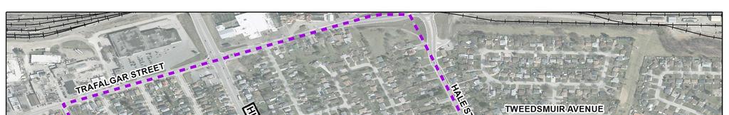
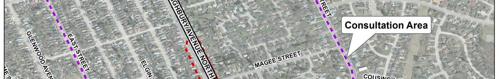
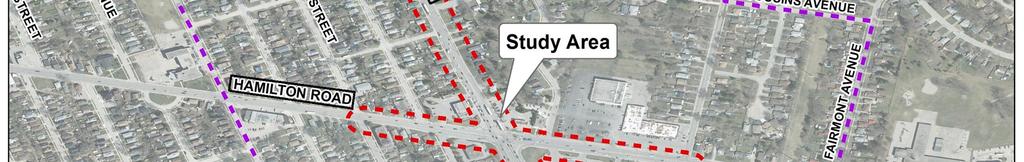
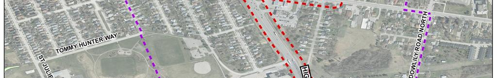
5 HIGHBURY AVENUE/HAMILTON ROAD STUDY AREA 5
 PHASE 5: Implementation")


 (2011) for a Schedule C (major) project.")


6 CLASS EA PROCESS PHASE 1: Problem/ Opportunity PHASE 2: Alternative Solutions PHASE 3: Design Options for Preferred Solution PHASE 4: Environmental Study Report (ESR) PHASE 5: Implementation ü Identify problems/ opportunities to be addressed in the planning and design process ü Confirm the need for intersection improvements as proposed in the Transportation Master Plan ü Prepare a Problem Statement ü Develop alternative design solutions based on intersection improvements ü Overview of existing and future conditions ü Consultation with review agencies and the public PUBLIC INFORMATION CENTRE 1 May 14, 2015 WE ARE HERE The Study is following the requirements of the Municipal Class Environmental Assessment (EA) (2011) for a Schedule C (major) project. The Class EA process ensures: ü All relevant social, environmental and engineering factors are considered in the planning and design process ü Public and agency input is integrated into the EA process. ü Identify design options for the preferred solution ü Detailed overview of existing/future conditions ü Evaluate design options and select a preferred design option ü Consultation with review agencies and the public ü Complete an impact assessment of the preferred design option PUBLIC INFORMATION CENTRE 2 Fall 2015 ü Document the decisionmaking process in an ESR for a Schedule C project ü Design and construction phase ü Project must be designed and constructed as outlined in the ESR The Highbury Avenue/Hamilton Road project will follow all five phases of the Class EA process: Phases 1 and 2, as covered by the 2030 Transportation Master Plan, will be reviewed and updated. A preferred solution will be chosen at the end of Phase 2 following PIC #1 Phase 3 will evaluate design options for implementing the preferred solution. A preferred design will be chosen at the end of Phase 3 In Phase 4, the ESR will be placed on the public record for a 30-day public and agency review period. 6


7 SOCIO-ECONOMIC ENVIRONMENT Legend Community Commercial Node Existing On-Road Bike Lane Potential On-road Bike Lane Multi-Use Pathway Bus Stops 7


8 EXISTING TRAFFIC CONDITIONS


9 PROJECTED TRAFFIC CONDITIONS NO IMPROVEMENTS 9
10 ACCESS MANAGEMENT What is Access Management? Access Management is a tool for coordinating land use planning and transportation planning/design. The objectives of access management are to reduce collisions, alleviate traffic congestion, reduce energy consumption, preserve the long term integrity of traffic movements and promote an aesthetically pleasing corridor. Proper access control maintains a high level of service for straight-through traffic and provides reasonable access to abutting properties. The principles of good access management are: Good traffic flow is essential for successful development Good access management is essential to support traffic flow that may be associated with achieving development objectives Good access management ensures that municipal road corridors can meet current/projected transportation needs. Without good access management, the function and character of corridors can deteriorate rapidly. Failure to manage access can cause: Increase in vehicular collisions Reduction in roadway efficiency Increase in commute times, fuel consumption and vehicular emissions since numerous access points and traffic signals intensify road network congestion. 10


 ISSUE:")
11 ACCESS MANAGEMENT Managing access alleviates traffic congestion and back-ups and improves safety. Access management changes being considered at the intersection are: Right-in /Right-out access use medians to physically restrict left-turns causing conflicts with other traffic movements Entrance closures eliminate entrances in close proximately to the intersection subject to availability of other entrances Bus bays provide street-side bus stops offset from traffic lanes Bicycle lanes provide separation between vehicular traffic and slower moving cyclists. ISSUE: Long back-ups and delays (Hamilton Rd looking North) ISSUE: Unrestricted traffic access (Coventry Ave. looking south) ISSUE: Heavy traffic volumes (Highbury Ave. looking north) 11
12 PUBLIC & AGENCY CONSULTATION TO DATE Residents: Almost 140 members of the public replied to the Notice of Study Commencement with 45 submitting comments: General Concerns Timing and length of construction Property and access impacts Pedestrian and cyclist safety, especially for children High traffic volumes and speed of traffic on local streets Sidewalks, stop signs and traffic calming measures should be installed on local streets Very difficult to back out of driveways on Highbury Avenue during peak periods Too many collisions at intersection. Improvement Suggestions Inset bus bays Restricted access to Giles Street from Hamilton Road during peak periods and no parking on Giles Street from Calvin Street to Highbury Avenue Restrict turning movements to Coventry Avenue and plaza Designated turning lane for access to residences along Highbury Avenue Redirect truck traffic from Highbury Avenue to Veterans Memorial Parkway Designated turning lanes from Hamilton Road to Highbury Avenue. Agencies: London Transit Commission (LTC) will consolidate some bus stops and integrate bus bays into the design. 12

 Requires a protected phase Protected phase improves safety of this traffic movement Requires a southbound dual or slotted left turn lane Potential")
 High volume of opposing traffic means that this will not improve *Level of Service (LOS) A - Unrestricted Capacity (Free flowing")
 F - Over Capacity (Road cannot handle traffic volume) Highbury Avenue Northbound Straight-through (LOS E)* Long traffic backup (390m) Traffic volume exceeds capacity Increase green time")
13 ALTERNATIVE DESIGN SOLUTIONS Traffic Movement Highbury Avenue Northbound Left-turn (LOS F)* Issue Long traffic backup (254m) with insufficient lane length Long delay (>180 sec/vehicle) Traffic volume exceeds capacity Alternative Design Solutions Increase green time for advance left Provide dual left turn lanes Provide longer left turn lane Key Considerations Creates longer delays for other traffic Increases pavement width, affecting pedestrian crossing time for Hamilton Road Potential property impacts Affects painted stop line placement on west leg of intersection, reducing available left turn storage (eastbound straight-through lane) Requires a protected phase Protected phase improves safety of this traffic movement Requires a southbound dual or slotted left turn lane Potential for property and utility impacts north of intersection Longer left only provides storage for vehicles in waiting to turn left, reducing interference in straight-through lane and improving safety Does not improve the delay Reduce opposing traffic (provide more gaps) High volume of opposing traffic means that this will not improve *Level of Service (LOS) A - Unrestricted Capacity (Free flowing traffic) B - Affected Capacity (Traffic volume is stable) C - Disturbed Capacity (Traffic volume is stable) D - Restricted Capacity (Difficult to navigate) E - Approaching Capacity (More difficult to navigate) F - Over Capacity (Road cannot handle traffic volume) Highbury Avenue Northbound Straight-through (LOS E)* Long traffic backup (390m) Traffic volume exceeds capacity Increase green time Increase capacity (number of straightthrough lanes) Provide a continuous two-way left turn lane from Calvin Street to the end of Southbound Left Turn Lane Reduce downstream interference at commercial entrances (apply access management. See Board 10) Note: Issues are based on 2025 projected traffic volumes (Weekday afternoon rush hour) Creates longer delays for other traffic movements Increases pavement width, affecting pedestrian crossing time for Hamilton Road High potential for property impacts Downstream merge creates a bottleneck Results in less downstream interference to straight-through traffic movements Provides safer turning traffic movements for access to residential entrances (reduces potential for rear-end collisions) Potential property impacts Results in less disruption to straight-through traffic movements and potential for rear-end collisions Impacts access to commercial properties 13
 Creates longer delays for other traffic movements Increases pavement width, affecting pedestrian clearance time for Hamilton Road High potential for property impacts")
 Results in less disruption to straight-through traffic movement and potential for rear-end collisions Impacts access to commercial properties (LOS F)* Provide a separate right turn lane")
 A - Unrestricted Capacity (Free flowing traffic) B - Affected Capacity (Traffic volume is stable) C - Disturbed Capacity (Traffic volume is stable) D -")
 Moderate delay (57sec/veh) Provide longer left turn lane Provide dual left turn lanes Note: Issues are based on 2025 projected traffic volumes (Weekday afternoon rush")
14 ALTERNATIVE DESIGN SOLUTIONS Traffic Movement Issue Alternative Design Solutions Key Considerations Highbury Avenue Southbound Straight -through/ Right Increase green time Increase capacity (number of straightthrough lanes) Creates longer delays for other traffic movements Increases pavement width, affecting pedestrian clearance time for Hamilton Road High potential for property impacts Downstream merge creates conflict point Long traffic backup (349m) Traffic volume exceeds capacity Reduce interference at Esso/Tim Horton's entrance (apply access management. See Board 10) Results in less disruption to straight-through traffic movement and potential for rear-end collisions Impacts access to commercial properties (LOS F)* Provide a separate right turn lane Results in less disruption to straight-through traffic movement and potential for rear-end collisions Increases pavement width, affecting pedestrian clearance time for Hamilton Road Potential property impacts *Level of Service (LOS) A - Unrestricted Capacity (Free flowing traffic) B - Affected Capacity (Traffic volume is stable) C - Disturbed Capacity (Traffic volume is stable) D - Restricted Capacity (Difficult to navigate) E - Approaching Capacity (More difficult to navigate) F - Over Capacity (Road cannot handle traffic volume) Highbury Avenue Southbound Left-turn (LOS E)* Moderate traffic backup (41m) Moderate delay (57sec/veh) Provide longer left turn lane Provide dual left turn lanes Note: Issues are based on 2025 projected traffic volumes (Weekday afternoon rush hour) Longer left provides storage for vehicles waiting to turn left, reducing interference in straight-through lane Does not improve the delay Increases pavement width, affecting pedestrian clearance time for Hamilton Road Potential property impacts Affects painted stop line placement on east leg of intersection, reducing available left turn storage (westbound left turn) Requires a protected phase Protected phase improves safety of this traffic movement Requires a dual or slotted northbound left turn lane 14
 D - Restricted Capacity (Difficult to navigate) E - Approaching Capacity (More difficult to navigate) F - Over Capacity (Road cannot handle traffic volume) Traffic Movement Issue Alternative")
 Traffic volume exceeds capacity Long traffic backup (190m) Long delay (124sec/veh) Traffic volume exceeds capacity Moderate delay (63sec/veh) Increase green time Increase capacity")
 Increase left turn lane storage at Hale Street Eliminate eastbound left turn to Coventry Street Increase green time Increase storage length Provide a channelized right turn lane")

15 ALTERNATIVE DESIGN SOLUTIONS *Level of Service (LOS) A - Unrestricted Capacity (Free flowing traffic) B - Affected Capacity (Traffic volume is stable) C - Disturbed Capacity (Traffic volume is stable) D - Restricted Capacity (Difficult to navigate) E - Approaching Capacity (More difficult to navigate) F - Over Capacity (Road cannot handle traffic volume) Traffic Movement Issue Alternative Design Solutions Key Considerations Hamilton Road Eastbound Straight-through (LOS F)* Hamilton Road Eastbound Right-turn (LOS F)* Hamilton Road Eastbound Left-turn Long traffic backup (248m) Long delay (>180sec/veh) Traffic volume exceeds capacity Long traffic backup (190m) Long delay (124sec/veh) Traffic volume exceeds capacity Moderate delay (63sec/veh) Increase green time Increase capacity (number of straight-through lanes) Increase capacity beyond Hale Street to eliminate merge occurring between Highbury and Hale Reduce interference at commercial entrances (apply access management. See Board 10) Increase left turn lane storage at Hale Street Eliminate eastbound left turn to Coventry Street Increase green time Increase storage length Provide a channelized right turn lane Increase storage length Creates longer delays for other traffic movements Increases pavement width, affecting pedestrian clearance time High potential for property impacts Downstream merge creates bottleneck Planned widening Potential property impacts Reduces interference by vehicles turning into commercial entrances Results in less disruption to straight-through traffic movement and potential for rear-end collisions Impacts access to commercial properties Provides more storage for high volume of left turns, reducing impact on the eastbound straight-through. Does not improve weave condition Reduces downstream interference to eastbound straight-through traffic, particularly at a location that is very close to the Highbury intersection Creates longer delays for other traffic movements Longer right only provides storage for vehicles waiting to turn left, reducing interference on the straight-through lane. Does not improve the delay Creates an essentially free-flow traffic movement, providing significant operational improvement Potential for property impact Longer left provides storage for vehicles waiting to turn left, reducing interference in the straight-through lane Does not improve the delay (LOS E)* Note: Issues are based on 2025 projected traffic volumes (Weekday afternoon rush hour) 15

 Requires a protected phase Protected phase improves safety of this traffic movement Requires a dual or slotted eastbound left turn lane Longer left only provides storage for vehicles waiting to")

 C - Disturbed Capacity (Traffic volume is stable) D - Restricted Capacity (Difficult to navigate) E - Approaching Capacity (More difficult to navigate) F - Over Capacity")
16 ALTERNATIVE DESIGN SOLUTIONS Traffic Movement Issue Alternative Design Solutions Key Considerations Hamilton Road Westbound Left-turn (LOS F)* Long traffic backup (163m) Long delay (>180sec/veh) Traffic volume exceeds capacity Increase green time for advanced left Provide dual left turn lanes Increase storage length Creates longer delays for other traffic movements Increases pavement width, affecting pedestrian clearance time for Highbury Ave Potential property impacts Affects painted stop line placement on south leg of intersection, reducing available left turn storage (northbound left turn) Requires a protected phase Protected phase improves safety of this traffic movement Requires a dual or slotted eastbound left turn lane Longer left only provides storage for vehicles waiting to turn left, reducing interference in straight-through lane and improving safety Does not improve the delay Reduce opposing traffic (provide more gaps) High volume of opposing traffic means that this will not improve Hamilton Road Westbound Straight-through/ Right Create bus bay downstream of Highbury to avoid interference to straight-through traffic movement Reduces interference caused by buses parking for longer duration than a normal stop (driver transition and washroom breaks occur here) *Level of Service (LOS) A - Unrestricted Capacity (Free flowing traffic) B - Affected Capacity (Traffic volume is stable) C - Disturbed Capacity (Traffic volume is stable) D - Restricted Capacity (Difficult to navigate) E - Approaching Capacity (More difficult to navigate) F - Over Capacity (Road cannot handle traffic volume) (LOS D)* Moderate traffic backup (100m) Moderate delay (42sec/veh) Consolidate upstream bus stops to eliminate the stop immediately east of Highbury Provide a separate right turn lane Note: Issues are based on 2025 projected traffic volumes (Weekday afternoon rush hour) Eliminates the stop immediately east of Highbury Ave, reducing the capacity of the right lane Provides less disruption to straight-through traffic movement and potential for rear-end collisions Increases pavement width, affecting pedestrian clearance time for Highbury Ave Potential property impacts 16


17 EXAMPLES OF DESIGN SOLUTIONS Dual Left-turn Lanes Slotted Left-turn Lanes Opposing Dual Left-turn Lanes and Slotted Left-turn Lane 17
18 ACCESS MANAGEMENT Potential Access Modifications for Consideration Refer to Board 19 for description of access changes 18
19 ACCESS MANAGEMENT To reduce traffic congestion at the intersection and comply with the City s Access Management Guidelines, the following access changes are being considered: 1. No eastbound left-turn to Coventry Avenue from Hamilton Road 2. No westbound left-turn from Hamilton Road to gas station 3. Close eastbound Hamilton Road gas station access 4. Close southbound Highbury Avenue gas station access 5. No eastbound left-turn from Hamilton Road to Fairmont Shopping Plaza 6. No northbound left from Norlan Avenue to Hamilton Road 7. No westbound left from Hamilton Road to Norlan Avenue 8. No southbound left from Highbury Avenue to restaurant 9. No westbound left from Hamilton Road to restaurant 10. No eastbound left from Hamilton Road to gas station 11. No southbound left from Conventry Avenue to Hamilton Road 12. Close northbound Highbury Avenue gas station access (north of intersection) 13. Close northbound Highbury Avenue gas station access (south of intersection) Refer to Board 18 for locations of access changes 19
 LONDON CITY COUNCIL APPROVAL 30-DAY ESR PUBLIC REVIEW PERIOD 2015 JUNE JULY AUGUST")
20 NEXT STEPS REVIEW AND RESPOND TO COMMENTS RECEIVED AT PIC REFINE ALTERNATIVE DESIGN SOLUTIONS & SELECT PREFERRED SOLUTION IDENTIFY & EVALUATE DESIGN OPTIONS SELECT PREFERRED DESIGN OPTION PUBLIC INFORMATION CENTRE 2 DEVELOP FUNCTIONAL DESIGN OF PREFERRED DESIGN OPTION PREPARE ENVIRONMENTAL STUDY REPORT (ESR) LONDON CITY COUNCIL APPROVAL 30-DAY ESR PUBLIC REVIEW PERIOD 2015 JUNE JULY AUGUST SEPTEMBER OCTOBER NOVEMBER THANK YOU FOR ATTENDING Your input is important to the outcome of this project. Please complete a comment form and return it by MAY 31, 2015 Personal information collected and recorded at the Public Information Centre or submitted in writing on this subject is collected under the authority of the Municipal Act, 2011 and will be used by members of Council and City of London staff in their review of this matter. With the exception of personal information, all comments will become part of the public record. Questions about this collection should be referred to the City Clerk s office at
CITY OF OTTAWA ROADWAY MODIFICATION APPROVAL UNDER DELEGATED AUTHORITY
 RMA-2015-ATM-038 CITY OF OTTAWA ROADWAY MODIFICATION APPROVAL UNDER DELEGATED AUTHORITY DATE: April 22, 2015 SUBJECT Approval of Roadway Modifications Recommended through an Area Traffic Management Study
WELCOME Public Information Centre
 WELCOME Public Information Centre Fernforest Drive Brampton Soccer Centre Community Room #2 Tuesday January 19, 2016 6:30 p.m.to 9:00 p.m. Please sign in Neighbourhood Traffic Calming Guide Background
Southcote Road Improvements Class Environmental Assessment Study
 1 Southcote Road Improvements Class Environmental Assessment Study Public Information Centre #1 May 24, 2018 Study Area 2 3 Welcome The Ancaster Transportation Master Plan (2011) outlined a long range
Public Information Centre
 WELCOME Public Information Centre Father Tobin Road Lougheed Middle School - Library Wednesday November 7, 2012 7:00 p.m.to 9:00 p.m. Please sign in Neighbourhood Traffic Calming Guide Background The City
Intersection Improvement: Sturgeon Road, Silver Avenue and Murray Park Road Roundabout. Welcome. Public Information Session
 Intersection Improvement: 1 Welcome WHY IS AN INTERSECTION IMPROVEMENT NEEDED? 2 Traffic volumes for Sturgeon Road, Silver Avenue and Murray Park Road exceed the capacity of the existing 4-way stop controlled
Bay to Bay Boulevard Complete Streets Project
 Bay to Bay Boulevard Complete Streets Project Dale Mabry Highway to Bayshore Boulevard February 08, 2018 Photo Source: Tampa Bay Times Alessandra Da Pra Meeting Format Introduction Resurfacing Information
Draft North Industrial Area-Wide Traffic Plan
 Summary of North Industrial and Hudson Bay Industrial Recommended Improvements Table 1. Summary of s Item Location 1 2 3 4 5 6 7 8 9 10 11 12 Millar Ave north of 51st St Super 8 Motel back lane 400 Block
County Road 2 Long Sault Improvements EA Study Schedule C Municipal Class Environmental Assessment. Environmental Study Report
 Study Schedule C Municipal Class Environmental Assessment Prepared By: BT Engineering 100 Craig Henry Drive, Suite 201 Ottawa, ON K2G 5W3 (613) 228-4813 (855) 228-4813 Toll free Executive Summary Executive
Scarlett Road Bridge & Road Improvements Lambton Park Community School - Gymnasium Tuesday November 28 th, 2017
 Scarlett Road Bridge & Road Improvements Lambton Park Community School - Gymnasium Tuesday November 28 th, 2017 PROJECT LOCATION 2 SCARLETT ROAD BRIDGE Constructed in 1912, the bridge carries 4 active
4. ENVIRONMENTAL IMPACT ANALYSIS 9. TRANSPORTATION AND TRAFFIC
 4. ENVIRONMENTAL IMPACT ANALYSIS 9. TRANSPORTATION AND TRAFFIC 4.9.1 INTRODUCTION The following section addresses the Proposed Project s impact on transportation and traffic based on the Traffic Study
Edenbrook Hill Drive Traffic Calming Study
 WELCOME Public Information Centre Edenbrook Hill Drive Traffic Calming Study Fletchers Meadow Secondary School Wednesday January 20, 2016 6:30 p.m.to 9:00 p.m. Please sign in Neighbourhood Traffic Calming
INNOVATIVE INTERSECTION DESIGN
 INNOVATIVE INTERSECTION DESIGN J. Eddie Valtier, P.E. ELP TP&D Director Introduction Why Do We Need To Start Looking For Innovative Intersection Designs? Congestion is worsening and traffic volumes and
Summary: Mercer County Princeton Avenue & Spruce Street Study January 2009
 Summary: Several recent studies have assessed potential development and redevelopment opportunities in the Mercer Crossing area of Trenton, Ewing, and Lawrence. This Princeton Avenue and Spruce Street
Richmond-Adelaide Cycle Tracks
 Public Drop-In Event Richmond-Adelaide Cycle Tracks June 25, 2018 12:00 p.m. 3:00 p.m. 4:30 p.m. 7:30 p.m. Metro Hall, Rotunda 55 John Street 1 Purpose of Event In Scope Communicate an update about the
Tonight is for you. Learn everything you can. Share all your ideas.
 Strathcona Neighbourhood Renewal Draft Concept Design Tonight is for you. Learn everything you can. Share all your ideas. What is Neighbourhood Renewal? Creating a design with you for your neighbourhood.
Blair/Williamson Intersection Expressed Needs
 Blair/Williamson Intersection Expressed Needs NORTH Blair Street is a barrier for pedestrians and bicycles Relocate Capitol City Trail crossing from Blair Street and John Nolen Drive intersection to Williamson
TRAFFIC CALMING GUIDE FOR TORONTO CITY OF TORONTO TRANSPORTATION SERVICES DIVISION
 TRAFFIC CALMING GUIDE FOR TORONTO CITY OF TORONTO TRANSPORTATION SERVICES DIVISION CITY OF TORONTO TRANSPORTATION SERVICES DIVISION 2016 TRAFFIC CALMING GUIDE FOR TORONTO TABLE OF CONTENTS Introduction
AGENDA REPORT. Issue: Discussion of potential improvements on Barnwell Road at Niblick Drive
 AGENDA REPORT To: From: By: Honorable Mayor and City Council Members Warren Hutmacher, City Manager Tom Black, Public Works Director Date: March 23, 2016 Agenda: March 28, 2016 WORK SESSION AGENDA: Barnwell
OFFICE/RETAIL DEVELOPMENT 1625 BANK STREET OTTAWA, ONTARIO TRANSPORTATION BRIEF. Prepared for: Canada Inc.
 OFFICE/RETAIL DEVELOPMENT 1625 BANK STREET OTTAWA, ONTARIO TRANSPORTATION BRIEF Prepared for: 9402209 Canada Inc. December 15, 2015 115-625 Report_2.doc D. J. Halpenny & Associates Ltd. Consulting Transportation
Project Report. South Kirkwood Road Traffic Study. Meadows Place, TX October 9, 2015
 Meadows Place, TX October 9, 2015 Contents 1 Introduction... 1 2 Data Collection... 1 3 Existing Roadway Network... 2 4 Traffic Volume Development... 2 5 Warrant Analysis... 3 6 Traffic Control Alternative
Tonight is an opportunity to learn about the Study and ask questions of the Study Team members.
 Exhibit 1 Welcome Second Open House Tonight is an opportunity to learn about the Study and ask questions of the Study Team members. A first Public Open House was held on September 18th, 2013 which presented
TRANSPORTATION NEEDS ASSESSMENT
 TRANSPORTATION NEEDS ASSESSMENT A travel demand analysis was carried out to determine the operational issues and the potential benefit that adding traffic capacity would have on the road network. All the
AIRPORT ROAD ENVIRONMENTAL ASSESSMENT
 WELCOME TO PUBLIC INFORMATION CENTRE #1 AIRPORT ROAD ENVIRONMENTAL ASSESSMENT From Braydon Boulevard/Stonecrest Drive to Countryside Drive November 23, 2017 6:30 PM 8:30 PM Please sign in and fill out
Welcome. If you have any questions or comments on the project, please contact:
 Welcome This drop-in public open house is intended to provide information about the Bay Street bike lanes project. This project proposes a dedicated cycling facility along Bay Street between Aberdeen Avenue
Harrah s Station Square Casino
 Transportation Analysis Harrah s Station Square Casino Pittsburgh, Pennsylvania Submitted To: City of Pittsburgh and Pennsylvania Gaming Control Board Prepared By: DKS Associates GAI Consultants December
DEPARTMENT OF ENVIRONMENTAL SERVICES. North Harrison Street (Lee Highway to Little Falls Road) Comparative Analysis. Prepared for:
 Comparative Analysis. Prepared for:") DEPARTMENT OF ENVIRONMENTAL SERVICES North Harrison Street (Lee Highway to Little Falls Road) Comparative Analysis Prepared for: Arlington County Department of Environmental Services 2100 Clarendon Boulevard,
DEPARTMENT OF ENVIRONMENTAL SERVICES North Harrison Street (Lee Highway to Little Falls Road) Comparative Analysis Prepared for: Arlington County Department of Environmental Services 2100 Clarendon Boulevard,
MEDICAL/OFFICE BUILDING 1637 BANK STREET OTTAWA, ONTARIO TRANSPORTATION OVERVIEW. Prepared for:
 MEDICAL/OFFICE BUILDING 1637 BANK STREET OTTAWA, ONTARIO TRANSPORTATION OVERVIEW Prepared for: 2434984 Ontario Inc. 13-5510 Canotek Road Ottawa, Ontario K1J 9J5 June 4, 2015 115-613 Report_2.doc D. J.
BETHEL ROAD AND SEDGWICK ROAD CORRIDOR STUDY
 DRAFT PLAN City Council Meeting August 14, 2017 STUDY AREA Sedgwick Corridor State Route 160, principal arterial with Class 3 access management designation, commuter and freight route, connection to SR
Welcome. Welcome to the second open house on the Downtown Transportation Study.
 Welcome 1 Welcome to the second open house on the Downtown Transportation Study. The purpose of this meeting is to: Recap the study objectives Summarize feedback to date Present information on the alternatives
MCTC 2018 RTP SCS and Madera County RIFP Multi-Modal Project Eval Criteria GV13.xlsx
 MCTC 8 RTP SCS and Madera County RIFP Multi-Modal Project Eval Criteria GV.xlsx Madera County Transportation Commission Regional Transportation Plan / Sustainable Communities Strategy Multi-Modal Project
2014/2015 BIKE ROUTE PLAN 83 AVENUE PROTECTED BIKE LANE
 About the Project 2014/2015 BIKE ROUTE PLAN The City of Edmonton is planning a major bike route on the south side of Edmonton. This bike route is one part of a plan to provide citizens with transportation
122 Avenue: 107 Street to Fort Road
 : 107 Street to Fort Road November 24, 2015 4:30 8:00 p.m. Meeting Purpose Summarize project work completed to date Share results of public input from Phase 1 Share the draft concept plan and proposed
Chapter 5. Complete Streets and Walkable Communities.
 Chapter 5. Complete Streets and Walkable Communities. 5.1 Description of Complete Streets. Cities throughout the world, and specifically the United States, are coming to embrace a new transportation and
MUTCD Part 6G: Type of Temporary Traffic Control Zone Activities
 MUTCD Part 6G: Type of Temporary Traffic Control Zone Activities 6G.01 Typical Applications Each temporary traffic control (TTC) zone is different. Many variables, such as location of work, highway type,
TRAFFIC IMPACT ANALYSIS
 TRAFFIC IMPACT ANALYSIS FOR THE CHAMPAIGN UNIT#4 SCHOOL DISTRICT PROPOSED HIGH SCHOOL (SPALDING PARK SITE) IN THE CITY OF CHAMPAIGN Final Report Champaign Urbana Urbanized Area Transportation Study 6/24/2014
Public Involvement Outreach Requirements for Public Information Open House Meeting: C.N , HSIP-5003(12) 132 nd and West Center Road, Omaha
 132 nd and West Center Road, Omaha") To: NDOR Environmental From: Randy McCart, HDR Date: 4 April 2017 RE: Public Involvement Summary Report, HSIP-5003(12) 132 nd and West Center Road, Omaha; C.N. 22629 Public Involvement Outreach Requirements
To: NDOR Environmental From: Randy McCart, HDR Date: 4 April 2017 RE: Public Involvement Summary Report, HSIP-5003(12) 132 nd and West Center Road, Omaha; C.N. 22629 Public Involvement Outreach Requirements
Traffic Study of Fuller Street, Cady Street, West Street and West Avenue. Final Report
 Traffic Study of Fuller Street, Cady Street, West Street and West Avenue Final Report July 2005 Prepared for: Town of Ludlow Prepared by: Pioneer Valley Planning Commission 26 Central Street West Springfield,
Northbound San Jose Avenue & I-280 Off-Ramp Road Diet Pilot Project
 Project Overview Fed by a two-lane Interstate-280 (I-280) off-ramp, high vehicular volumes and speeds are longstanding issues along San Jose Avenue. Residents in the surrounding neighborhoods have expressed
Welcome to the Open House
 Leslie Street Between 19 th Avenue and Stouffville Road Addendum to Class Environmental Assessment Study Welcome to the Open House Please sign in at the front desk. March 28, 2017 Richmond Green Sports
City of Wausau Wausau Center Urban Design and Transportation Master Plan. Design Workshop // October 18, 2018
 City of Wausau Wausau Center Urban Design and Transportation Master Plan Design Workshop // October 18, 2018 Design Workshops // October 15-18 Workshop Study Evaluate circulation and parking patterns around
4 DISRUPTION MANAGEMENT PLAN HIGHWAY 7 RAPIDWAY CONSTRUCTION BETWEEN BAYVIEW AVENUE AND WARDEN AVENUE TOWNS OF MARKHAM AND RICHMOND HILL
 4 DISRUPTION MANAGEMENT PLAN HIGHWAY 7 RAPIDWAY CONSTRUCTION BETWEEN BAYVIEW AVENUE AND WARDEN AVENUE TOWNS OF MARKHAM AND RICHMOND HILL The Transportation Services Committee recommends the adoption of
Waterford Lakes Small Area Study
 Waterford Lakes Small Area Study Existing Traffic Conditions PREPARED FOR: ORANGE COUNTY PUBLIC WORKS DEPARTMENT TRAFFIC ENGINEERING DIVISION ORLANDO, FLORIDA PREPARED WITH: INWOOD CONSULTING ENGINEERS
M-58 HIGHWAY ACCESS MANAGEMENT STUDY Mullen Road to Bel-Ray Boulevard. Prepared for CITY OF BELTON. May 2016
 M-58 HIGHWAY ACCESS MANAGEMENT STUDY Prepared for CITY OF BELTON By May 2016 Introduction Missouri State Highway 58 (M-58 Highway) is a major commercial corridor in the City of Belton. As development has
New Seward and 36 th Avenue Intersection Conceptual Design
 University of Alaska Anchorage New Seward and 36 th Avenue Intersection Conceptual Design Prepared By: Zaid S. Hussein Dana Menendez Galen Jones Civil Engineering Department Prof. Osama Abaza CE A404 Highway
WEST AND SOUTH WEST RING ROAD DOWNSTREAM TRAFFIC IMPACTS
 Page 1 of 9 EXECUTIVE SUMMARY Alberta Transportation ( AT ) is preparing to construct the final sections of the Calgary Ring Road. This includes the South West Ring Road ( SWRR ) (from Lott Creek Blvd
Los Altos Hills Town Council - June 18, 2015 Palo Alto City Council June 22, AGENDA ITEM #2.B Presentation
 Los Altos Hills Town Council - June 18, 2015 Palo Alto City Council June 22, 2015 AGENDA ITEM #2.B Presentation Previous Presentations Los Altos Hills Town Council in May 2014 and February 2015 Palo Alto
East 12 th Street Bikeway Feasibility Study
 Final Report East 12 th Street Bikeway Feasibility Study Prepared for: City of Oakland Public Works Agency Submitted by: 180 Grand Avenue, Suite 250 Oakland, CA 94612 Phone: (510) 839-1742; Fax: (510)
HENDERSON DEVELOPMENT 213, 217, 221, 221 ½, 223 HENDERSON AVENUE and 65 TEMPLETON STREET OTTAWA, ONTARIO TRANSPORTATION OVERVIEW.
 HENDERSON DEVELOPMENT 213, 217, 221, 221 ½, 223 HENDERSON AVENUE and 65 TEMPLETON STREET OTTAWA, ONTARIO TRANSPORTATION OVERVIEW Prepared for: 2294170 Ontario Inc. February 2, 2017 117-652 Report_1.doc
Chapter 4 Traffic Analysis
 Chapter 4 Traffic Analysis PURPOSE The traffic analysis component of the K-68 Corridor Management Plan incorporates information on the existing transportation network, such as traffic volumes and intersection
INDUSTRIAL BUILDING 3009 HAWTHORNE ROAD CITY OF OTTAWA TRANSPORTATION OVERVIEW REVISED. Prepared for: Canada Inc.
 INDUSTRIAL BUILDING 3009 HAWTHORNE ROAD CITY OF OTTAWA TRANSPORTATION OVERVIEW REVISED Prepared for: 7849648 Canada Inc. Octiober 1, 2015 114-598 Overview_2.doc D. J. Halpenny & Associates Ltd. Consulting
Brian McHugh, Buckhead Community Improvement District. SUBJECT: Wieuca Road at Phipps Boulevard Intersection Improvements Project
 MEMO TO: FROM: Brian McHugh, Buckhead Community Improvement District Jagan Kaja, AICP, WSP Parsons Brinckerhoff SUBJECT: Wieuca Road at Phipps Boulevard Intersection Improvements Project DATE: October
Terwillegar Drive Expressway Draft Concept Plan
 Terwillegar Drive Expressway Draft Concept Plan Anthony Henday Drive to Whitemud Drive November 28 5:00-8:00 p.m. December 1 10:00 a.m. - 3:00 p.m. Let s Talk Today you can: Learn about the new direction
Purpose: Financial Implications and Impact Statement: It is estimated that the cost to implement:
 Various Modifications Lower Jarvis Street and Lake Shore Boulevard East; Lower Jarvis Street, east side, between Lake Shore Boulevard East and The Esplanade - 45-77 Lower Jarvis Street; and Lower Jarvis
to the Public Information Centre for the Downtown Traffic Study
 to the Public Information Centre for the Downtown Traffic Study City of Sault Ste. Marie July 25, 2018 Purpose of Study Determine if changes to one-way corridors can enhance downtown s character and spaces
FAIRFIELD INN & SUITES HOTEL 135 THAD JOHNSON PRIVATE OTTAWA TRANSPORTATION BRIEF. Prepared for:
 FAIRFIELD INN & SUITES HOTEL 135 THAD JOHNSON PRIVATE OTTAWA TRANSPORTATION BRIEF Prepared for: Bona Building & Management Co. Ltd. Place Vanier, 333 North River Road Vanier, Ontario K1L 8B9 August 12,
Queensboro Bridge Bus Priority Study: Summary of Recommendations. Presentation to Manhattan Community Board 8 May 4, 2011
 : Summary of Recommendations Presentation to Manhattan Community Board 8 May 4, 2011 1 Overview Study Goal: Identify cost-effective ways to improve bus speed and reliability for local and express buses
Harbord Street and Hoskin Avenue Bicycle Lane Upgrades
 STAFF REPORT ACTION REQUIRED and Bicycle Lane Upgrades Date: April 22, 2014 To: From: Wards: Reference Number: Public Works and Infrastructure Committee General Manager, Transportation Services 19 and
COWETA HIGH SCHOOL AND EAST HIGHWAY 51
 COWETA HIGH SCHOOL AND EAST HIGHWAY 51 Lack of sidewalks along Ben Lumpkin Rd. Lack of crosswalks and ramps at intersection. Hwy 51 is wide to cross as a pedestrian. No ADA compliance or connection to
INDUSTRIAL BUILDING 1660 COMSTOCK ROAD CITY OF OTTAWA TRANSPORTATION OVERVIEW. Prepared for:
 INDUSTRIAL BUILDING 1660 COMSTOCK ROAD CITY OF OTTAWA TRANSPORTATION OVERVIEW Prepared for: Simluc Contractors Limited 2550 Blackwell Street, Ottawa K1B 5R1 October 18, 2013 113-584 Overview_1.doc D. J.
CITY OF LOS ANGELES INTER-DEPARTMENTAL MEMORANDUM
 CITY OF LOS ANGELES INTER-DEPARTMENTAL MEMORANDUM Date: April 1, 219 To: Honorable City Council c/o City Clerk, Room 395, City Hall Attention: Honorable Mike Bonin, Chair, Transportation Committee From:
Appendix C. TRAFFIC CALMING PROGRAM TOOLBOX
 Appendix C. TRAFFIC CALMING PROGRAM TOOLBOX PHASE I...2 Do Not Enter Sign...3 One-Way Sign...4 Turn Prohibition...5 Pavement Markings...6 Speed Monitoring Trailer...7 Neighborhood Speed Watch...8 Police
HILTON GARDEN INN HOTEL HOTEL EXPANSION 2400 ALERT ROAD, OTTAWA TRANSPORTATION BRIEF. Prepared for:
 HILTON GARDEN INN HOTEL HOTEL EXPANSION 2400 ALERT ROAD, OTTAWA TRANSPORTATION BRIEF Prepared for: Bona Building & Management Co. Ltd. Place Vanier, 333 North River Road Vanier, Ontario K1L 8B9 October
Transportation Corridor Studies: Summary of Recommendations
 Transportation Corridor Studies: Summary of Recommendations Route 4 Corridor Study: Route 10 Corridor Study: Route 44 Corridor Study: Route 175 Corridor Study: Route 5/15 Corridor Study: Rentschler Field
3 TRAFFIC CONTROL SIGNAL TIMING AND SYNCHRONIZATION
 Report No. 8 of the Transportation Services Committee Regional Council Meeting of October 20, 2011 3 TRAFFIC CONTROL SIGNAL TIMING AND SYNCHRONIZATION The Transportation Services Committee recommends:
2014/2015 BIKE ROUTE PLAN 83 AVENUE PROTECTED BIKE LANE
 About the Project The City of Edmonton is planning a major bike route on the southside of Edmonton. The Strathcona Bike Route will connect the communities of Strathcona, Garneau and the University area,
WELCOME. Stakeholder Involvement Group Meeting #2 Round Lake Public Works October 24, 2018
 WELCOME Stakeholder Involvement Group Meeting #2 Round Lake Public Works October 24, 2018 MEETING AGENDA 1. Welcome and Introductions 2. Study Progress Update 3. Problem Statement 4. Technical Analysis
Edgemont Village Traffic and Parking Technical Report January 2014
 Edgemont Village Traffic and Parking Technical Report January 2014 In the fall of 2013, the District of North Vancouver engaged consultants to assess existing intersection and parking conditions in Edgemont
HOLIDAY INN HOTEL 235 KING EDWARD AVENUE CITY OF OTTAWA TRANSPORTATION BRIEF. Prepared for:
 HOLIDAY INN HOTEL 235 KING EDWARD AVENUE CITY OF OTTAWA TRANSPORTATION BRIEF Prepared for: Momentum Planning & Communications 1165 Greenlawn Crescent Ottawa, ON K1L 6C2 June 29, 2015 115-618 Brief_1.doc
CITY OF VAUGHAN EXTRACT FROM COUNCIL MEETING MINUTES OF NOVEMBER 15, 2016
 CITY OF VAUGHAN EXTRACT FROM COUNCIL MEETING MINUTES OF NOVEMBER 15, 2016 Item 6, Report No. 38, of the Committee of the Whole, which was adopted without amendment by the Council of the City of Vaughan
CITY OF SASKATOON COUNCIL POLICY
 ORIGIN/AUTHORITY Clause 1, Report No. 1-1980 and Clause 4, Report No. 22-1990 of the Works and Utilities Committee; Clause 6, Report No. 17-2004 of the Planning and Operations Committee; and Clause D5,
Highway 49, Highway 351 and Highway 91 Improvements Feasibility Study Craighead County
 Highway 49, Highway 351 and Highway 91 Improvements Feasibility Study Craighead County Executive Summary March 2015 Highway 49, Highway 351 and Highway 91 Improvements Feasibility Study Craighead County
BLUE SEA VILLAGE MER BLEUE 2159 MER BLEUE ROAD OTTAWA, ONTARIO TRANSPORTATION IMPACT ASSESSMENT. Prepared for: Ontario Limited.
 BLUE SEA VILLAGE MER BLEUE 2159 MER BLEUE ROAD OTTAWA, ONTARIO TRANSPORTATION IMPACT ASSESSMENT Prepared for: 2534189 Ontario Limited April 6, 2018 117-668 TIA Report_2.doc D. J. Halpenny & Associates
Improving Cyclist Safety at the Dundas Street West and Sterling Road Intersection
 STAFF REPORT ACTION REQUIRED Improving Cyclist Safety at the Dundas Street West and Sterling Road Intersection Date: August 17, 2012 To: From: Wards: Reference Number: Public Works and Infrastructure Committee
3.0 PROJECT DESCRIPTION
 The following section of the Draft EIR contains a description of the proposed Elk Grove Boulevard/SR 99 Interchange Modification project, consistent with the requirements of CEQA Guidelines Section 15124.
Toronto and East York Community Council. Director, Transportation Services, Toronto and East York District
 No Turn on Red Regulations STAFF REPORT ACTION REQUIRED Date: June 1, 2010 To: From: Toronto and East York Community Council Director, Transportation Services, Toronto and East York District Wards: Trinity
10 th STREET BRIDGE REPLACEMENT Schedule 'C' EA: Phase 3 Presentation to Council Recommended Design Alternatives City of Owen Sound August 27, 2018
 10 th STREET BRIDGE REPLACEMENT Schedule 'C' EA: Phase 3 Presentation to Council Recommended Design Alternatives City of Owen Sound August 27, 2018 May 2015 1 AGENDA 1. Overview of Municipal Class EA Process.
D.13 Transportation and Traffic
 This section addresses transportation and traffic issues and impacts related to the Proposed Project. Section D.13.1 provides a description of the affected environment for the Proposed Project. Applicable
Frequently Asked Questions (FAQ)
") Frequently Asked s (FAQ) Study Process... 2 Rapid Transit Service and Operations... 5 Public Consultation... 8 Business Impacts... 8 Design and Property Impacts... 9 Construction Impacts...12 Traffic,
Frequently Asked s (FAQ) Study Process... 2 Rapid Transit Service and Operations... 5 Public Consultation... 8 Business Impacts... 8 Design and Property Impacts... 9 Construction Impacts...12 Traffic,
Public Works Committee Meeting Richard E. Mastrangelo Council Chamber November 20, 2017
 Public Works Committee Meeting Richard E. Mastrangelo Council Chamber November 20, 2017 Purpose of Meeting Why are we here? Project Recap/Updates Project Limits/Segments Road Diet Concept Lessons Learned
Downey Road. Transportation Improvement Study
 Downey Road Transportation Improvement Study Workshop 2 Participant Handbook Workshop 1 May 18 and 19, 2016 Workshop 2 June 23 and 28, 2016 Prepared By: City of Guelph Paradigm Transportation Solutions
ALLEY 24 TRAFFIC STUDY
 ALLEY 24 TRAFFIC STUDY in City of Frostburg, Maryland January 2013 3566 Teays Valley Road Hurricane, WV Office: (304) 397-5508 www.denniscorporation.com Alley 24 Traffic Study January 2013 Frostburg, Maryland
Appendix C. NORTH METRO STATION AREA TRAFFIC IMPACT STATEMENT 88th Avenue Station
 Appendix C NORTH METRO STATION AREA TRAFFIC IMPACT STATEMENT 88th Avenue Station Prepared for: Regional Transportation Department and URS Corporation as part of the North Metro EIS David Evans and Associates,
A plan for improved motor vehicle access on Railroad Avenue in Provincetown
 A plan for improved motor vehicle access on Railroad Avenue in Provincetown February 2011 A plan for improved motor vehicle access on Railroad Avenue in Provincetown INTRODUCTION AND PROBLEM IDENTIFICATION
P.O. Box 1749 Halifax, Nova Scotia B3J 3A5 Canada Item No Halifax Regional Council September 18, 2018
 P.O. Box 1749 Halifax, Nova Scotia B3J 3A5 Canada Item No. 14.1.6 Halifax Regional Council September 18, 2018 TO: SUBMITTED BY: Mayor Savage and Members of Halifax Regional Council Original Signed Jacques
City of Gainesville Transportation/Roadway Needs PROJECT SUMMARY
 A1 Roadway Resurfacing $23,846,000 TYPE: Preservation of existing system Roadway resurfacing A2 Signal Replacement $6,000,000 TYPE: Preservation of existing system Replace traffic signals. B1 W 6th St
Dowling/Beaty Cycling Route
 Public Meeting #2 Dowling/Beaty Cycling Route May 17, 2017 6:00 p.m. 8:00 p.m. Parkdale Public Library - Auditorium 1303 Queen Street West How to Participate Share your questions, ideas and concerns We
Lawrence Avenue Streetscape Concepts August 30, 2011
 Lawrence Avenue Streetscape Concepts August 30, 2011 Neighborhood Context Phase II: River to Western Ave. Phase I: Western Ave. to Clark St. Key Map Lawrence Ave. Existing Streetscape Conditions East of
Protected Bike Lanes in San Francisco Mike Sallaberry SFMTA NACTO Workshop - Chicago IL
 Protected Bike Lanes in San Francisco Mike Sallaberry SFMTA 10 14 2011 NACTO Workshop - Chicago IL San Francisco 2 nd Highest Density in the U.S. 47 square miles Mild Climate Market Population ~810,000
Glenn Avenue Corridor Traffic Operational Evaluation
 Glenn Avenue Corridor Traffic Operational Evaluation PREPARED FOR: THE CITY OF AUBURN PREPARED BY: DECEMBER 2007 Glenn Avenue Corridor Study--Auburn, Alabama TABLE OF CONTENTS Introduction... 1 Background
Congestion Management Report
 Congestion Management Report F.E. EVERETT TURNPIKE (NORTH), MERRIMACK Segment Length: 7.0 miles Daily Traffic Volumes: 60,000-69,000 Analysis Period: May 2015 Number of Traffic Signals: 0 Number of travel
Appendix B. Environmental Resource Technical Memorandum. Assessment on Travel Pattern and Access Impacts
 Appendix B Environmental Resource Technical Memorandum Assessment on Travel Pattern and Access Impacts TECHNICAL MEMORANDUM ENVIRONMENTAL RE-EVALUATION FOR UNION STATION TO OAK CLIFF DALLAS STREETCAR To:
McKenzie Interchange Project Fall 2015 Engagement. Appendix 2: Engagement Materials and Feedback Form
 Fall 2015 Engagement Appendix 2: Engagement Materials and Feedback Form Welcome to the McKenzie Interchange Project Open House! Purpose of Open House To provide you with information regarding the project
Non-Motorized Transportation 7-1
 Non-Motorized Transportation 7-1 Transportation facilities no longer mean just accommodating a vehicle powered by a combustion engine. Pedestrian and non-motorized facilities are important modes of travel
DOWNTOWN TUPELO MAIN STREET: ROAD DIET STUDY
 DOWNTOWN TUPELO MAIN STREET: ROAD DIET STUDY Since mid-2009, RPM Transportation Consultants (RPM) has worked with the Downtown Tupelo Main Street Association to evaluate traffic conditions and potential
MEMORANDUM. Earl Haugen and UND Transportation and Traffic Coordination Committee
 SRF No. 7766 MEMORANDUM TO: FROM: Earl Haugen and UND Transportation and Traffic Coordination Committee Rick Lane, P.E. DATE: November 26, 2013 SUBJECT: UNIVERSITY AVE REVIEW Our review of the University
Coquitlam Cross-town Bike Route Improving Bicycle Facilities in a Mature Suburban Environment
 Coquitlam Cross-town Bike Route Improving Bicycle Facilities in a Mature Suburban Environment Sarah Rocchi, Vice-President, Projects, Opus International Consultants (Main Presenter) Catherine Mohoruk,
Welcome! San Jose Avenue Open House August 25, 2015
 Welcome! San Jose Avenue Open House August 25, 2015 Vision Zero The City and County of San Francisco adopted Vision Zero San Francisco Vision Zero High Injury Network as a policy in 2014, committing an
Intersection Safety 6/7/2015 INTERSECTIONS. Five basic elements should be considered in intersection design. Intersection Safety (continued)
") Intersection Safety S. M. SOHEL MAHMUD Assistant Professor Accident Research Institute (ARI), Bangladesh University of Engineering and Technology (BUET) Dhaka-1000, Bangladesh 1 Outline of the Presentation
Intersection Safety S. M. SOHEL MAHMUD Assistant Professor Accident Research Institute (ARI), Bangladesh University of Engineering and Technology (BUET) Dhaka-1000, Bangladesh 1 Outline of the Presentation
Boston Post Road Design Feasibility Study
 Boston Post Road Design Feasibility Study Prepared for the City of Rye Final Report July 18, 2007 Prepared by: Buckhurst Fish & Jacquemart (BFJ) 115 Fifth Avenue New York, NY 10003 www.bfjplanning.com
Southview Blvd & 3 rd Avenue Improvement Project. Public Open House December 4, to 7pm
 Southview Blvd & 3 rd Avenue Improvement Project Public Open House December 4, 2014 5 to 7pm Southview Blvd & 3 rd Avenue Public Information Meeting Agenda Presentation 5:30 to 6:15 pm Purpose of Project