PennDOT Access Management Model Ordinances Training
|
|
|
- Kristian Brian Owens
- 5 years ago
- Views:
Transcription


1 PennDOT Access s Training Trainers: Chad Dixson, AICP, TPD Angela Watson, PB
2 Objective of Today Assist Pennsylvania s municipalities and transportation professionals in better understanding the benefits of access management and guide them in the development and implementation of a program for their community that can be used as a tool for responsible growth. Evaluation 2
3
4 What is Access? The Transportation Research Board s (TRB) Access Manual defines access management as the systematic control of the location, spacing, design, and operation of driveways, median openings, interchanges, and street connections to a roadway. It also involves roadway design applications, such as median treatments and auxiliary lanes, and the appropriate spacing of traffic signals. Evaluation 4
5 Access Principles Provide specialized roadway system Limit direct access to major roadways Promote intersection hierarchy Signalization for through movements Preserve function areas of intersections Evaluation 5
6 Access Principles (cont.) Limit the number of conflict points Separate conflict areas Remove turning vehicles from through traffic Use non traversable medians Provide supporting street network Evaluation 6

7 Why Access? Increasing safety concerns Increasing congestion on transportation facilities Limited resources Evaluation 7
8 Safety Benefits of Access Reductions in Total Crashes: Two-way Left Turn Lane: 35% Non-traversable Median: 35% Add Left Turn Lane: 25-50% Add Right Turn Lane: 20% Source: TRB, Access Manual, 2003 Evaluation 8
9 Operational Benefits of Access Increases in Capacity: Two-way Left Turn Lane: 30% Non-traversable Median: 30% Add Left Turn Lane: 25% Source: TRB, Access Manual, 2003 Evaluation 9

10 Community Benefits Linking transportation and land use Balancing mobility and accessibility Improved mobility on local roads Improved safety for cyclists and pedestrians Evaluation 10
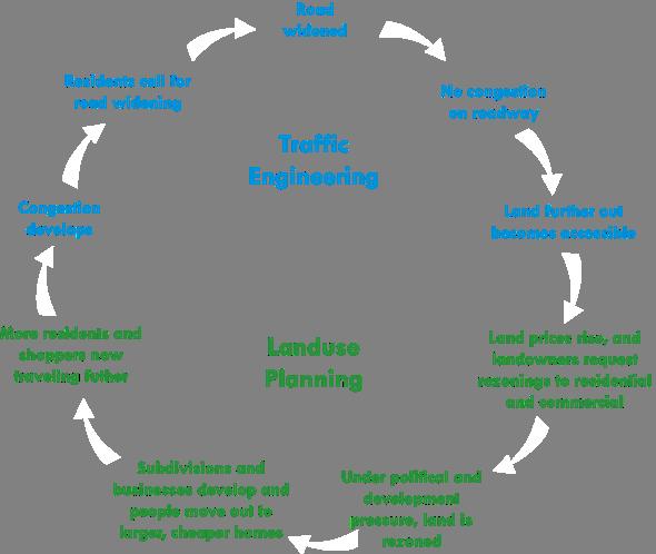
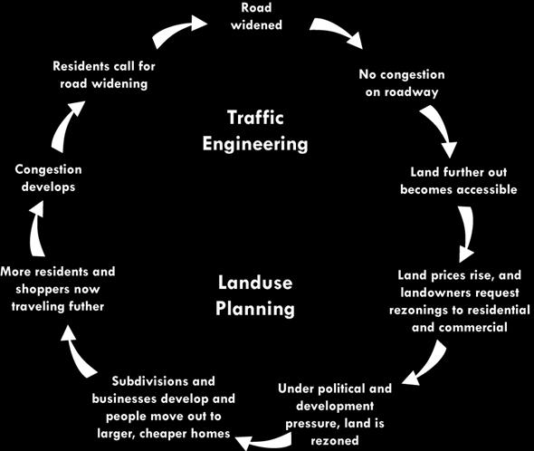
11 Linking Transportation and Land Use Evaluation 11

12 Balancing Mobility and Access Evaluation 12
13 Legal Basis for Access Control Pennsylvania Code Municipalities Planning Code (MPC) Case Law Ice v. Cross Roads Borough Township of Middle Smithfield v. Kessler Evaluation 13
14 Pennsylvania Code Pennsylvania Code, Title 67, Chapter 441: Access to and Occupancy of Highways by Driveways and Local Roads. The purpose of Chapter 441 is to assure safe and reasonable access as well as safe and convenient passage of traffic on the State highway. Evaluation 14
15 Municipalities Planning Code Pennsylvania Municipalities Planning Code (MPC) is the enabling legislation for local planning providing: A uniform approach to planning and land use regulations; and An asset to communities that choose to join together and address common problems. Evaluation 15
16 MPC Techniques Some of the land use management tools that are available at the local level include: Subdivision design and control; Mixed use zoning; Restriction of commercial strip zoning; High density and cluster zoning; Transit oriented development; Official map; Overlay districts; Elimination or restriction of flag lots; and Promotion of bicycle and pedestrian design. Evaluation 16

17 Challenges Local vs. regional perspectives Changing land uses Community and political opposition Addressing existing conditions Evaluation 17
18
19 s Purpose Provide vehicular access to land development in a manner that preserves safety and efficiency. Application Modify to fit your community Planning and Regulatory solutions Apply as appropriate Coordinate with PennDOT District Office Evaluation 19
20 Development Create model access management regulations that recognize: Transportation/land use connection; concepts differences for various communities (e.g., urban vs. rural); Consistency between subdivision and land use ordinance (SLDO) and zoning ordinance; Differences in model application County-level land use ordinances vs. local level Communities with a SLDO but no zoning Communities, which manage land use through single purpose ordinances rather than SLDO and zoning. Evaluation 20
21 Tiers Tier I consists of access management techniques for parcels; Tier II consists of access management techniques for roadways and Tier III includes comprehensive traffic planning techniques. Evaluation 21
22 Tier I Techniques Number of Driveways Corner Clearance Safe Sight Distance Driveway Channelization Joint and Cross Access Access to Out-parcels Driveway Design Elements Evaluation 22

23 Number of Driveways Evaluation 23
24 Number of Driveways Advantages Reduce the number of driveways and the number of conflict points along a roadway. Help preserve the capacity of the roadway. Allows greater speeds for through traffic. Evaluation 24
25 Number of Driveways Obstacles Multiple driveways are often needed for large traffic volume generators. Safe access cannot be provided on the roadway with the lower functional classification. Evaluation 25

26 Shared Driveways Evaluation 26

27 Shared Driveways Evaluation 27
28 Shared Driveways Advantages Reduce the number of driveways and the number of conflict points along a roadway. They are a safe and more efficient way to provide access to two adjacent land uses. Proper standards help avoid liability claims for a municipality. Evaluation 28
29 Shared Driveways Obstacles Shared driveways are difficult to retrofit as they usually apply to new developments. Easements, deeds, and letters of agreement are needed to resolve maintenance issues. Evaluation 29

30 Internal Access to Out parcels Evaluation 30

31 Internal Access to Out parcels Evaluation 31


32 Internal Access to Outparcels Internal access consists of an on-site circulation system that serves the out parcels, as well as the interior development. Requirements for internal access are most applicable to shopping centers and office parks. Evaluation 32
33 Internal Access to Outparcels Advantages Reduces the number of direct access points on major roadways in commercial and employment areas, thus reducing the number of conflict points. Evaluation 33
34 Internal Access to Outparcels Obstacles Property owners may avoid internal access requirements by individually selling out parcels. Some owners of out parcels may lobby for direct access to the roadway. Evaluation 34
35 Tier II Techniques Deceleration/Right Turn Lanes Left Turn Lanes Acceleration Lanes Driveway Spacing Signalized Intersection Spacing Driveway Clearance from Interchange Ramps Evaluation 35

36 Left Turn Lanes Evaluation 36

37 Left Turn Lanes Evaluation 37
38 Left Turn Lanes Advantages Allows left turn movements to be removed from the through lanes, reducing the delay for the through movement. Evaluation 38
39 Left Turn Lanes Obstacles May require substantial right-of-way involve the reconstruction of a considerable length of roadway in order to provide the appropriate transitions and lane shift tapers. Evaluation 39

40 Driveway Spacing Evaluation 40
41 Driveway Spacing Driveway spacing is the distance between two driveways. It creates a tangent distance between the end of the radius of one driveway and the beginning of the turning radius at the next driveway. Without such a requirement, a radius from one driveway could tie into the radius of an adjacent driveway using the other definitions. Evaluation 41
42 Driveway Spacing Advantages Standards reduce the number of access locations a motorist must monitor at one time. Adequate driveway spacing allows greater speeds for through traffic, reduces the number of potential conflict points and helps preserve the capacity of the roadway. Evaluation 42
43 Driveway Spacing Obstacles Driveway spacing is difficult to implement in areas that are already developed, such as in commercial areas or corridors. It is also difficult to implement this practice when there are no supporting land use regulations governing lot frontage or dimensions. Evaluation 43

44 Signalized Intersection Spacing Evaluation 44
45 Signalized Intersection Spacing Advantages Prevents queues from one intersection backing into an adjacent intersection. Provides better traffic flow progression. Limiting the number of signals can reduce the number of locations where queues may block driveways. Evaluation 45
46 Signalized Intersection Spacing Obstacles Difficult to implement in established commercial areas. Mid-block high volume driveways may require signalization and often break uniform spacing standards. Evaluation 46
47 Tier III Techniques Access Overlay District Official Map Two-way Left Turn Lanes Frontage/Service Roads Non-traversable Medians Evaluation 47
48 Access Overlay District Established for corridors, interchanges or intersections. Address concerns regarding safety, access and capacity problems. Land use requirements for large trip generators. Setbacks, signing and landscaping Planning study/implementation. Evaluation 48
49 Official Map Existing and proposed public streets, including widening, extensions, openings or closings. Pedestrian facilities and easements. Railroad and transit rights-of-way and easements. Evaluation 49

50 Frontage Roads Evaluation 50
51 Frontage Roads Evaluation 51
52 Frontage Roads Advantages Minimize the number of access points on an arterial. Separate local traffic from high speed through traffic. Evaluation 52
53 Frontage Roads Obstacles Short spacing can cause queues that extend through the intersections. They could result in severe congestion and high crash rates. Contribute to commercial strip development rather than compact activity centers. Very difficult to retrofit in fully developed areas. Evaluation 53
54 Service Roads Evaluation 54

55 Setbacks Evaluation 55
56 Setbacks Advantages Assist in preserving right-of-way for future widening for turn lanes or additional through lanes. Evaluation 56
57 Setbacks Obstacles Irregular lot dimensions may preclude meeting setback standards. Evaluation 57
58 Pre-existing Access Advantages Provides the municipality a tool to implement access management for existing driveways when there is a change in use, expansion of the existing use or modifications to the existing driveway are requested. Evaluation 58
59 Pre-existing Access Obstacles Absent special conditions, the municipality cannot impose immediate and in some cases very expensive retrofit designs. Retrofit of existing access along a corridor can take many years to implement. Evaluation 59


60
61 - Before Evaluation 61
62 - Evaluation 62

63 - Before Evaluation 63
64 - Evaluation 64

65 Example - Before Evaluation 65

66 Example - Evaluation 66

67 Example - Before Evaluation 67

68 Example - Evaluation 68

69 Example - Before Evaluation 69

70 Example - Evaluation 70
71 Coordination of HOP and Municipal Approval Process Developers commonly approach the completion of their municipal approval without ever having discussed their project with PennDOT. This is often precipitated by the misunderstanding that PennDOT requires municipal land development approval prior to considering the project. Approvals or agreements between developers and municipalities may unintentionally conflict with PennDOT regulations, standards or policies. In some instances, PennDOT is forced to insist upon changes that may require repeating the municipal land development approval process. Evaluation 71
72 Improving Coordination of the Development Process Municipalities should encourage developers to seek PennDOT comments as early in the municipal review process as possible. Preliminary comments should be sought on critical items such as driveway location, number of driveways and appropriate signal locations. Municipalities should require that developers include all municipal review letters in their HOP submission to PennDOT. Municipalities should request from PennDOT the opportunity to review HOP s before the Department accepts the application for processing. Coordination between the municipality and Evaluation PennDOT is needed throughout the process. 72
73 Communication and Coordination with PennDOT Municipalities are strongly encouraged to continue communication and coordination with the PennDOT District office before, during and after the development of their program and the adoption of ordinance changes. Evaluation 73
74 PennDOT Access s Training Trainers: Chad Dixson, AICP, TPD Angela Watson, PB
Access Management Regulations and Standards
 Access Management Regulations and Standards January 2014 Efficient highway operation Reasonable property access Concept of Access Management The way to manage access to land development while preserving
Access Location, Spacing, Turn Lanes, and Medians
 Design Manual Chapter 5 - Roadway Design 5L - Access Management 5L-3 Access Location, Spacing, Turn Lanes, and Medians This section addresses access location, spacing, turn lane and median needs, including
Access Management Benefits & Techniques. Access Management Workshop June 2, 2006
 Access Management Benefits & Techniques Access Management Workshop June 2, 2006 1 Benefits of Access Management Safety As access density increases, crash rates increase Increasing the density of access
Access requests to County streets and roadways are processed through one of the following methods:
 13.1 GENERAL APPLICATION PROCESS Access requests to County streets and roadways are processed through one of the following methods: A. Planned Developments may set general locations for access points.
Access Management Regulations and Standards for Minor Arterials, Collectors, Local Streets
 Access Management Regulations and Standards for Minor Arterials, Collectors, Local Streets September 2009 Paul Grasewicz Access Management Administrator Concept of Access Management The way to manage access
City of Homewood Transportation Plan
 City of Homewood Transportation Plan Prepared for: City of Homewood, Alabama Prepared by: Skipper Consulting, Inc. May 2007 TABLE OF CONTENTS INTRODUCTION... 1 BACKGROUND INFORMATION... 1 EXISTING TRANSPORTATION
Access Management Regulations and Standards
 Access Management Regulations and Standards Efficient highway operation Reasonable property access Concept of Access Management The way to manage access to land development while simultaneously preserving
Background on the Revisions to VDOT s Access Management Spacing Standards
 December 2011 Background on the Revisions to VDOT s Access Management Spacing Standards Spacing Standards for Commercial Entrances, Signals, Intersections, and Crossovers The spacing standards were located
CHAPTER 7 ACCESS MANAGEMENT. Background. Principles of Access Management. Hennepin County Transportation Systems Plan (HC-TSP)
") CHAPTER 7 ACCESS MANAGEMENT Background Principles of Access Management Hennepin County Transportation Systems Plan (HC-TSP) Chapter 7 Access Management 7.1 Background Access management has become an important
CHAPTER 7 ACCESS MANAGEMENT Background Principles of Access Management Hennepin County Transportation Systems Plan (HC-TSP) Chapter 7 Access Management 7.1 Background Access management has become an important
M-58 HIGHWAY ACCESS MANAGEMENT STUDY Mullen Road to Bel-Ray Boulevard. Prepared for CITY OF BELTON. May 2016
 M-58 HIGHWAY ACCESS MANAGEMENT STUDY Prepared for CITY OF BELTON By May 2016 Introduction Missouri State Highway 58 (M-58 Highway) is a major commercial corridor in the City of Belton. As development has
Central Arkansas Regional Transportation Study Area ROADWAY DESIGN STANDARDS And Implementation Procedures
 Central Arkansas Regional Transportation Study Area ROADWAY DESIGN STANDARDS And Implementation Procedures These standards have been prepared for the use of all jurisdictions to incorporate into their
1 VicRoads Access Management Policies May 2006 Ver VicRoads Access Management Policies May 2006 Version 1.02
 1 VicRoads Access Management Policies May 2006 Ver 1.02 VicRoads Access Management Policies May 2006 Version 1.02 2 VicRoads Access Management Policies May 2006 Ver 1.02 FOREWORD FOR ACCESS MANAGEMENT
Clackamas County Comprehensive Plan
 ROADWAYS The County s road system permits the movement of goods and people between communities and regions, using any of a variety of modes of travel. Roads provide access to virtually all property. They
Chapter 2: Standards for Access, Non-Motorized, and Transit
 Standards for Access, Non-Motorized, and Transit Chapter 2: Standards for Access, Non-Motorized, and Transit The Washtenaw County Access Management Plan was developed based on the analysis of existing
CIRCLE DRIVE TRAFFIC AND ACCESS MANAGEMENT POLICY GUIDE. Management Principles and Implementation Concepts
 CIRCLE DRIVE TRAFFIC AND ACCESS MANAGEMENT POLICY GUIDE A. PREFACE Management Principles and Implementation Concepts The intent of this policy guide is to provide interim guidance on the implementation
WYDOT DESIGN GUIDES. Guide for. Non-NHS State Highways
 WYDOT DESIGN GUIDES Guide for Non-NHS State Highways 2014 GUIDE FOR Non-NATIONAL HIGHWAY SYSTEM (Non-NHS) STATE HIGHWAYS PRESERVATION REHABILITATION RECONSTRUCTION INTRODUCTION This Guide is directed to
SELECTED ROADWAY CAPACITY ANALYSIS
 CHAPTERFOUR SELECTED ROADWAY CAPACITY ANALYSIS 4.1 SELECTED ROADWAY CAPACITY ANALYSIS Introduction Capacity analysis was performed on six selected roadways within the Dearborn County study area using the
INDEX. Geometric Design Guide for Canadian Roads INDEX
 Acceleration lane, see Lanes, Acceleration Access, 8.1 Access Management and Functional Classification 8.2 Access Management by Design Classification 8.3 Access Configuration 8.4 Building Set-Back Guidelines
T A B L E OF C O N T E N T S
 T A B L E OF C O N T E N T S PART III SUBDIVISION REGULATIONS OF THE DEPARTMENT OF PUBLIC WORKS, C & C D PAGE PAGE Responsibility for Development of Streets......... 29 Right-of-Way Widths...... 37 Purpose...........
SECTION 1 - TRAFFIC PLANNING
 SECTION 1 - TRAFFIC PLANNING 1.1 TRAFFIC OPERATIONS 1.1.1 Roadway Functional Classification The Multnomah County Comprehensive Framework Plan s Policy 34: Trafficways and the Functional Classification
Access Management in the Vicinity of Intersections
 Access Management in the Vicinity of Intersections FHWA-SA-10-002 Technical Summary Photo: Ralph Bentley (used with permission) 0 Access Management is: The design, implementation and management of entry
Iowa Corridor Management Pilot Project Overview. Recommendations For A Corridor Management Program August 2004
 Iowa Corridor Management Pilot Project Overview Recommendations For A Corridor Management Program August 2004 Presentation Overview Project goals Pilot project selection process Analysis results Segment
WYDOT DESIGN GUIDES. Guide for. NHS Arterial (Non-Interstate)
") WYDOT DESIGN GUIDES Guide for NHS Arterial (Non-Interstate) 2014 GUIDE FOR NATIONAL HIGHWAY SYSTEM (NHS) HIGHWAYS (NHS ARTERIALS, Non-Interstate) PRESERVATION REHABILITATION RECONSTRUCTION INTRODUCTION
WYDOT DESIGN GUIDES Guide for NHS Arterial (Non-Interstate) 2014 GUIDE FOR NATIONAL HIGHWAY SYSTEM (NHS) HIGHWAYS (NHS ARTERIALS, Non-Interstate) PRESERVATION REHABILITATION RECONSTRUCTION INTRODUCTION
TRAFFIC AND SAFETY NOTE 608A. Spacing for Commercial Drives and Streets. To Promote a Uniform Practice in Determining Access Spacing
 TRAFFIC AND SAFETY NOTE 608A SUBJECT: PURPOSE: Spacing for Commercial Drives and Streets To Promote a Uniform Practice in Determining Access Spacing COORDINATING UNIT: Geometric Design Unit INFORMATION:
This Chapter sets forth the minimum design, technical criteria and specifications to be used in the preparation of all roadway plans.
 4.1 GENERAL This Chapter sets forth the minimum design, technical criteria and specifications to be used in the preparation of all roadway plans. These Roadway Standards are for new construction and modification
MUTCD Part 6G: Type of Temporary Traffic Control Zone Activities
 MUTCD Part 6G: Type of Temporary Traffic Control Zone Activities 6G.01 Typical Applications Each temporary traffic control (TTC) zone is different. Many variables, such as location of work, highway type,
Recommended Roadway Plan Section 2 - Land Development and Roadway Access
 Recommended Roadway Plan Section 2 - Land Development and Roadway Access SECTION 2 Land Development and Roadway Access 2.1 Land Use and Access Management The Federal Highway Administration (FHWA) defines
APPENDIX A: Complete Streets Checklist DRAFT NOVEMBER 2016
 APPENDIX A: Complete Streets Checklist DRAFT NOVEMBER 2016 Complete Streets Checklist MetroPlan Orlando s Complete Streets Checklist is an internal planning tool for staff to further implementation of
Brian D. Hare, P.E. Bureau of Design PennDOT PA APA Annual Conference Investing in a Sustainable Future October 5, 2009
 Brian D. Hare, P.E. Bureau of Design PennDOT 2009 PA APA Annual Conference Investing in a Sustainable Future October 5, 2009 1 What is Smart Transportation? Photographer: heyjude. Used through license
Access Management Design Standards for Entrances and Intersections
 Access Management Design Standards for Entrances and Intersections July 2012 APPENDIX F VDOT Road Design Manual PREFACE The access management regulations and standards do not apply in cities, towns of
Alberta Infrastructure HIGHWAY GEOMETRIC DESIGN GUIDE AUGUST 1999
 Alberta Infrastructure HIGHWAY GEOMETRIC DESIGN GUIDE AUGUST 1999,1'(; A ACCELERATION Data on acceleration from stop D-29 Effects of grade D-35 Intersections D-97, D-99 Lanes D-97, F-5, F-7, F-15, F-21,
Corpus Christi Metropolitan Transportation Plan Fiscal Year Introduction:
 Introduction: The Safe, Accountable, Flexible, Efficient Transportation Equity Act: A Legacy for Users (SAFETEA-LU) has continued the efforts started through the Intermodal Surface Transportation Efficiency
Frequently Asked Questions
 Frequently Asked Questions Business US 190 in Copperas Cove From Avenue D to Constitution Drive What is access management? A. Access Management is a growing effort by government agencies to improve how
Chapter 4 Traffic Analysis
 Chapter 4 Traffic Analysis PURPOSE The traffic analysis component of the K-68 Corridor Management Plan incorporates information on the existing transportation network, such as traffic volumes and intersection
West Dimond Blvd Upgrade Jodhpur Street to Sand Lake Road
 West Dimond Blvd Jodhpur St to Sand Lake CSS Transportation Project Summary Municipality of Anchorage Project # 05 005 Project Manager: John Smith, P.E. (MOA PM&E) Project Administrator: Julie Makela,
REGIONAL BICYCLE AND PEDESTRIAN DESIGN GUIDELINES
 REGIONAL BICYCLE AND PEDESTRIAN DESIGN GUIDELINES November 16, 2011 Deb Humphreys North Central Texas Council of Governments Bicycle and Pedestrian Advisory Committee Snapshot of the Guide 1. Introduction
General References Definitions. (1) Design Guidance. (2) Supporting Information
 Design Guidance. (2) Supporting Information") Chapter 1240 Turning Roadways 1240.01 General 1240.02 References 1240.03 Definitions 1240.04 Turning Roadway Widths 1240.05 Documentation 1240.01 General The roadway on a curve may need to be widened to
Chapter 1240 Turning Roadways 1240.01 General 1240.02 References 1240.03 Definitions 1240.04 Turning Roadway Widths 1240.05 Documentation 1240.01 General The roadway on a curve may need to be widened to
Roadway Classification Design Standards and Policies. Pueblo, Colorado November, 2004
 Roadway Classification Design Standards and Policies Pueblo, Colorado November, 2004 Table of Contents Page Chapter 1. General Provisions 1.1 Jurisdiction 3 1.2 Purpose and Intent 3 1.3 Modification 3
Classification Criteria
 SCHEDULE D TO RECOMMENDED OFFICIAL PLAN AMENDMENT NO. 40 SCHEDULE C-4 Road Criteria Criteria Traffic Service Objective Land Service/Access Typical Daily Traffic Volume Flow characteristics Travel Speed
GOAL 2A: ESTABLISH AND MAINTAIN A SAFE, CONVENIENT, AND EFFICIENT MULTI-MODAL TRANSPORTATION SYSTEM TO MOVE PEOPLE AND GOODS THROUGHOUT THE CITY.
 2. TRANSPORTATION ELEMENT The purpose of this element is to assist in establishing an adequate transportation system within the City and to plan for future motorized and non-motorized traffic circulation
DRAFT - CITY OF MEDFORD TRANSPORTATION SYSTEM PLAN Roadway Cross-Sections
 Roadway Cross-Sections Medford s roadway cross-section standards apply to new and reconstructed roads. The crosssections take into consideration roadway function and operational characteristics, including
CHAPTER 17 ACCESS MANAGEMENT
 CHAPTER 17 ACCESS MANAGEMENT General 17-2 Permit Procedures 17-4 SDDOT-Owned Access Rights 17-4 Access Management Rules 17-4 Figure 17-1 South Dakota Access Location Criteria Techniques 17-6 Consolidating
Toolbox of Alternatives
 Toolbox of Alternatives Mobility Enhancements Policy Improvements Travel Demand Management Other Geometric/Capacity/ Operational Improvements Access Management Safety Improvements Multi-Modal Improvements
Arterial Management Plan for US Route 250 and State Route 623
 Arterial Management Plan for US Route 250 and State Route 623 June 25, 2014 Brad Shelton, AICP Access Management and Traffic Impact Analysis Programs Manager Transportation and Mobility Planning Division
Highway 111 Corridor Study
 Highway 111 Corridor Study June, 2009 LINCOLN CO. HWY 111 CORRIDOR STUDY Draft Study Tea, South Dakota Prepared for City of Tea Sioux Falls Metropolitan Planning Organization Prepared by HDR Engineering,
1.3.4 CHARACTERISTICS OF CLASSIFICATIONS
 Geometric Design Guide for Canadian Roads 1.3.4 CHARACTERISTICS OF CLASSIFICATIONS The principal characteristics of each of the six groups of road classifications are described by the following figure
Route 29 Corridor Assessment Update. Development of Possible Solutions
 Route 29 Corridor Assessment Update Development of Possible Solutions Public Workshop #3 October 27, 2016 Purpose of Developing Possible Solutions Recap of where we ve been and timeline for moving forward
Chapter 6: Transportation
 Chapter 6: Transportation I. INTRODUCTION The purpose of the Transportation Plan element of the Comprehensive Plan is to provide guidance to the City of North Mankato, as well as existing and future landowners
RESOLUTION NO ?? A RESOLUTION OF THE CITY OF NEPTUNE BEACH ADOPTING A COMPLETE STREETS POLICY
 RESOLUTION NO. 2018-?? A RESOLUTION OF THE CITY OF NEPTUNE BEACH ADOPTING A COMPLETE STREETS POLICY WHEREAS, safe, convenient, and accessible transportation for all users is a priority of the City of Neptune
4.11 TRANSPORTATION/CIRCULATION
 4.11 TRANSPORTATION/CIRCULATION This section was developed using information from a Traffic Analysis Report prepared for the project by OEG, Inc. (2010), the Paradiso del Mare Ocean and Inland Estates
10.0 CURB EXTENSIONS GUIDELINE
 10.0 CURB EXTENSIONS GUIDELINE Road Engineering Design Guidelines Version 1.0 March 2017 City of Toronto, Transportation Services City of Toronto Page 0 Background In early 2014, Transportation Services
Regional Transportation Needs Within Southeastern Wisconsin
 Regional Transportation Needs Within Southeastern Wisconsin #118274 May 24, 2006 1 Introduction The Southeastern Wisconsin Regional Planning Commission (SEWRPC) is the official areawide planning agency
COMMITTEE RECOMMENDATIONS. That Council approve:
 4. MODIFICATIONS TO INNES ROAD (REGIONAL ROAD 30) AND TENTH LINE ROAD (REGIONAL ROAD 47) TO ACCOMMODATE THE DEVELOPMENT OF THE TRINITY COMMONS SHOPPING CENTRE COMMITTEE RECOMMENDATIONS That Council approve:
5. RUNNINGWAY GUIDELINES
 5. RUNNINGWAY GUIDELINES These guidelines should be considered collectively when making runningway decisions. A runningway is the linear component of the transit system that forms the right-of-way reserved
Active Transportation Infrastructure Investment A Business Case
 Active Transportation Infrastructure Investment A Business Case In 2016, the Real Estate Foundation awarded the Capital Regional District a $50,000 grant for Shifting Gears: Land Use Change through Active
Living Streets Policy
 Living Streets Policy Introduction Living streets balance the needs of motorists, bicyclists, pedestrians and transit riders in ways that promote safety and convenience, enhance community identity, create
Zlatko Krstulich, P.Eng. City of O9awa
 Zlatko Krstulich, P.Eng. City of O9awa 1. Introduction to the Ontario Traffic Manual Series 2. What is OTM Book 18: Bicycle Facilities? 3. Study / Committee Team Members 4. Brief overview of the content
Approaches. Livable Neighborhood Design. Examples. Traditional neighborhood development. CE 594 University of Wisconsin- Milwaukee
 Approaches Livable Neighborhood Design CE 594 University of Wisconsin- Milwaukee Traditional neighborhood design (TND), new urbanism, transit friendly design, transit oriented development and walkable
ACTIVE TRANSPORTATION
 ACTIVE TRANSPORTATION Mobility 2040 Supported Goals Improve the availability of transportation options for people and goods. Support travel efficiency measures and system enhancements targeted at congestion
Crosswalk Policy Revisions & Pedestrian & Bicycle Connection Plans. Presentation to Sanibel City Council July 16, 2013
 Crosswalk Policy Revisions & Pedestrian & Bicycle Connection Plans Presentation to Sanibel City Council July 16, 2013 Outline Crosswalk Policy Revisions Minimum Standards Goals and Objectives Pedestrian
CITY OF LUCAS 2014 MASTER THOROUGHFARE PLAN
 INTRODUCTION CITY OF LUCAS 2014 MASTER THOROUGHFARE PLAN A thoroughfare system is intended to provide an effective means of moving vehicles within and through a city. The thoroughfare plan will assist
Freeway System Considerations
 Session 11 Jack Broz, PE, HR Green May 5-7, 2010 Freeway System Considerations Mainline Transit: Shoulder Operations, BRT, Stations HOV, HOT, UPA Interchanges Exit Ramps Entrance Ramps Bridges Local Crossings
Chapter 5. Complete Streets and Walkable Communities.
 Chapter 5. Complete Streets and Walkable Communities. 5.1 Description of Complete Streets. Cities throughout the world, and specifically the United States, are coming to embrace a new transportation and
Median Design. Course No: C Credit: 4 PDH. Debra Kennaugh, P.E.
 Median Design Course No: C04-041 Credit: 4 PDH Debra Kennaugh, P.E. Continuing Education and Development, Inc. 9 Greyridge Farm Court Stony Point, NY 10980 P: (877) 322-5800 F: (877) 322-4774 info@cedengineering.com
City of Columbia Access Management Ordinance
 City of Columbia Access Management Ordinance TABLE OF CONTENTS Contents Article 1. Introduction... 3 SECTION 1.01 PURPOSE... 3 SECTION 1.02 JURISDICTION OF THESE REGULATIONS... 3 SECTION 1.03 RELATIONSHIP
Transportation Corridor Studies: Summary of Recommendations
 Transportation Corridor Studies: Summary of Recommendations Route 4 Corridor Study: Route 10 Corridor Study: Route 44 Corridor Study: Route 175 Corridor Study: Route 5/15 Corridor Study: Rentschler Field
5/31/2016 VIA . Arwen Wacht City of Sacramento Community Development Department 300 Richards Blvd., 3 rd Floor Sacramento, CA 95811
 5/31/2016 VIA EMAIL Arwen Wacht City of Sacramento Community Development Department 300 Richards Blvd., 3 rd Floor Sacramento, CA 95811 RE: El Pollo Loco (P16-028) Dear Ms. Wacht: WALKSacramento has reviewed
ACCESS MANAGEMENT GUIDELINES
 APRIL 2002 Prepared by the NASHUA REGIONAL PLANNING COMMISSION with funding by This project was funded in part by the New Hampshire Department of Transportation. APRIL 2002 Prepared by the NASHUA REGIONAL
AMATS Complete Streets Policy
 AMATS Complete Streets Policy Table of Contents: Section 1. Definition of Complete Streets Section 2. Principles of Complete Streets Section 3. Complete Streets Policy Section 4. Consistency Section 5.
APPENDIX F. Access Management Design Standards for Entrances and Intersections
 APPENDIX F Access Management Design Standards for Entrances and Intersections PREFACE The access management regulations and standards do not apply in cities, towns of more than 3,500 and in counties (Henrico
CITY OF SASKATOON COUNCIL POLICY
 ORIGIN/AUTHORITY Clause 1, Report No. 1-1980 and Clause 4, Report No. 22-1990 of the Works and Utilities Committee; Clause 6, Report No. 17-2004 of the Planning and Operations Committee; and Clause D5,
INTRODUCTION THOROUGHFARE SYSTEM CLASSIFICATIONS
 INTRODUCTION The thoroughfare plan will assist public officials in the development of a specialized system for efficient and safe movement of vehicular traffic while minimizing potential conflicts with
San Jose Transportation Policy
 San Jose Transportation Policy Protected Intersections in LOS Policies to Support Smart Growth Presented by: Manuel Pineda City of San Jose Department of Transportation Bay Area Map San Francisco Oakland
 COMPLETE STREETS CHECKLIST City of Philadelphia The City of Philadelphia's Complete Streets policies are designed ensure that city streets are safe, comfortable and convenient for people of all ages and
A5.1 Permitted activities
 Section A5 Transportation A5.1 Permitted activities A5.1.1 Activities within roads Note: Refer to Section D for the definition of road (a) Any activity associated with the movement of traffic and the functioning
1609 E. FRANKLIN STREET HOTEL TRAFFIC IMPACT STUDY EXECUTIVE SUMMARY
 1609 E. FRANKLIN STREET HOTEL TRAFFIC IMPACT STUDY EXECUTIVE SUMMARY Prepared for: The Town of Chapel Hill Public Works Department Traffic Engineering Division Prepared by: HNTB North Carolina, PC 343
Access Management Guidelines for the Urbanized Area
 Access Management Guidelines for the Urbanized Area April 2013 Table of Contents EXECUTIVE SUMMARY... 6 SECTION 1: INTRODUCTION TO ACCESS MANAGEMENT... 7 1.1 What is Access Management?... 7 1.2 Relationships
Chapter 6 Transportation Plan
 Chapter 6 Transportation Plan Transportation Plan Introduction Chapter 6 Transportation Plan Transportation Plan Introduction This chapter describes the components of Arvada s transportation system, comprised
o n - m o t o r i z e d transportation is an overlooked element that can greatly enhance the overall quality of life for the community s residents.
 N o n - m o t o r i z e d transportation is an overlooked element that can greatly enhance the overall quality of life for the community s residents. 84 Transportation CHAPTER 11 INTRODUCTION Transportation
City of Albert Lea Policy and Procedure Manual 4.10 ALBERT LEA CROSSWALK POLICY
 4.10 ALBERT LEA CROSSWALK POLICY PURPOSE: Pedestrian crosswalks are an integral part of our transportation infrastructure. To be effective and promote safety, marked crosswalks must be installed after
RAISED MEDIAN EFFECTIVENESS
 RAISED MEDIAN EFFECTIVENESS William E. Frawley, AICP Texas A&M Transportation Institute Access Management Overview Set of Tools to Help Improve Safety and Protect Public Investments in Roadways Balances
Appendix B MoDOT Access Management Guidelines
 Appendix B MoDOT Access Management Guidelines Meramec Regional Transportation Plan Page B-1 MISSOURI DEPARTMENT OF TRANSPORTATION ACCESS MANAGEMENT GUIDELINES September 12, 2003 Meramec Regional Transportation
PRINCE GEORGE S PLAZA METRO AREA PEDESTRIAN PLAN
 PRINCE GEORGE S PLAZA METRO AREA PEDESTRIAN PLAN May 28, 2008 Agenda Welcome and introductions Project overview and issue identification Planning context and strengths Design challenges and initial recommendations
APPROVE A RESOLUTION ADOPTING A COMPLETE STREETS POLICY
 STAFF REPORT MEETING DATE: September 13, 2016 TO: FROM: City Council Bob Brown, Community Development Director Russ Thompson, Public Works Director Patrick Filipelli, Management Analyst 922 Machin Avenue
Access Management Conference
 Reduce motorist delay Signals Pedestrians Access Management Conference September, 2004 Safety Intersection Improvements Project Description FM 518 provides east-west mobility and access to many retail,
Appendix D. US 54 /400 Study Area Proposed Access Management Code City of Andover, KS
 Access Control Appendix D US 54 /400 Study Area Proposed Access Management Code City of Andover, KS D1 Table of Contents Section 1: Purpose Section 2: Applicability Section 3: Conformance with Plans,
Chapter 7. Transportation. Transportation Road Network Plan Transit Cyclists Pedestrians Multi-Use and Equestrian Trails
 Chapter 7 Transportation Transportation Road Network Plan Transit Cyclists Pedestrians Multi-Use and Equestrian Trails 7.1 TRANSPORTATION BACKGROUND The District of Maple Ridge faces a number of unique
Roundabouts are good for business
 Roundabouts are good for business What is a roundabout Rules 0f Roundabouts 1. Slow down when approaching a roundabout 2. Yield to vehicles in the roundabout 3. When clear, proceed right into the roundabout
Access Management Guidelines February 2013 THE CITY OF
 Access Management Guidelines February 2013 THE CITY OF Table of Contents Introduction 2 Review and Approval Process 5 Technical Guidelines 9... 10... 12 3. Separation Distance: Non-Signalized All-Turns
APPENDIX B Boonville Code of Ordinances. BOONVILLE, MISSOURI Access Management Manual. March Revised April 2009 INDEX
 APPENDIX B Boonville Code of Ordinances BOONVILLE, MISSOURI Access Management Manual March 2002 Revised April 2009 INDEX Section Page 1.0 Introduction and Definitions. 2 2.0 Roadway Classification System.
Active Transportation Facility Glossary
 Active Transportation Facility Glossary This document defines different active transportation facilities and suggests appropriate corridor types. Click on a facility type to jump to its definition. Bike
Agenda. Overview PRINCE GEORGE S PLAZA METRO AREA PEDESTRIAN PLAN
 PRINCE GEORGE S PLAZA METRO AREA PEDESTRIAN PLAN May 28, 2008 Agenda Welcome and introductions Project overview and issue identification Planning context and strengths Design challenges and initial recommendations
MUNICIPALITY OF ANCHORAGE Traffic Department MEMORANDUM
 MUNICIPALITY OF ANCHORAGE DATE: MEMORANDUM TO: FROM: SUBJECT: Anchorage Contractors, Builders, Designers, and Land Owners Robert E. Kniefel, P.E., Municipal Traffic Engineer Municipal Driveway Standards
6/22/2018 VIA . Darcy Goulart, Planning Manager City of Rancho Cordova Planning Department 2729 Prospect Park Drive Rancho Cordova, CA 95670
 6/22/2018 VIA EMAIL Darcy Goulart, Planning Manager City of Rancho Cordova Planning Department 2729 Prospect Park Drive Rancho Cordova, CA 95670 RE: Quick Quack Car Wash (DD9801) Dear Ms. Goulart: WALKSacramento
David Hung, Associate Planner City of Sacramento Community Development Department 300 Richards Boulevard, 3 rd Floor Sacramento, CA
 June 13, 2016 VIA EMAIL David Hung, Associate Planner City of Sacramento Community Development Department 300 Richards Boulevard, 3 rd Floor Sacramento, CA 959811 RE: Fire Station 14 (DR16-128) Dear Mr.
Bicycle Lanes Planning, Design, Funding South Mountain Partnership Trails Workshop Roy Gothie PennDOT Statewide Bicycle Pedestrian Coordinator
 Bicycle Lanes Planning, Design, Funding 2018 South Mountain Partnership Trails Workshop Roy Gothie PennDOT Statewide Bicycle Pedestrian Coordinator Policy Changes: BOP Bicycle Policy Changes The OLD Way
Circulation in Elk Grove includes: Motor vehicles, including cars and trucks
 Circulation, as it is used in this General Plan, refers to the many ways people and goods move from place to place in Elk Grove and the region. Circulation in Elk Grove includes: Motor vehicles, including
TRANSPORTATION ANALYSIS REPORT US Route 6 Huron, Erie County, Ohio
 TRANSPORTATION ANALYSIS REPORT US Route 6 Huron, Erie County, Ohio December 12, 2012 Prepared for: The City of Huron 417 Main Huron, OH 44839 Providing Practical Experience Technical Excellence and Client
City of Wayzata Comprehensive Plan 2030 Transportation Chapter: Appendix A
 A1. Functional Classification Table A-1 illustrates the Metropolitan Council s detailed criteria established for the functional classification of roadways within the Twin Cities Metropolitan Area. Table
Transportation Planning Division
 Transportation Planning Division Presentation Outline Study Tasks Recap of Previous Meetings Data Collected Focus Areas within Study Limits Design Principles Tool Box Recommended Concepts Schedule Moving