Stakeholder Focus Group Meeting #3 January 9, 2013 Cattlemens, 2000 Taylor Road, Roseville
|
|
|
- Abraham Grant
- 5 years ago
- Views:
Transcription
1 PRESENT Stakeholder Focus Group Meeting #3 January 9, 2013 Cattlemens, 2000 Taylor Road, Roseville PROJECT TEAM REPRESENTATIVES Name Organization Celia McAdam Luke McNeel Caird Leo Heuston Judy Matsui Drury Gladys Cornell Ciara Zanze Sam Jordan STAKEHOLDER FOCUS GROUP PARTICIPANTS Organizations Represented Cattlemens Restaurant City of Rocklin City of Roseville Dry Creek Conservancy Golfland Sunsplash Pillar Hotels Rocklin Chamber of Commerce Stonehouse Property Sun City Roseville Taylor Road Self Storage Westfield Galleria William Jessup University Placer County Transportation Planning Agency Placer County Transportation Planning Agency CH2M Hill CH2M Hill AIM Consulting AIM Consulting Caltrans MEETING PURPOSE: Approximately 60 stakeholder representatives were invited to the third stakeholder focus group meeting for the I 80/SR 65 Interchange Improvement project. This key stakeholder group consists of a cross section of project vicinity property and business owners/tenants, residents, and other interested organizations that may be directly affected by the future I 80 / SR 65 Interchange Improvements project. The purpose of the meeting was to receive feedback from key stakeholders regarding the five alternatives. MEETING OBJECTIVES: Review the overall project including the study area, existing constraints and considerations, and current project phase.
2 Stakeholder Focus Group Meeting #3 January 9, 2013 Address questions or concerns about the overall project. Introduce the 5 alternatives and receive stakeholder input and feedback. Attachments (included at the end of this document) Stakeholder Focus Group Meeting Invitation January 9, 2013 PowerPoint Presentation Project Overview The I 80/SR 65 Interchange Improvements project proposes to improve the I 80/SR 65 interchange including widening I 80 between Douglas Blvd and Rocklin Road, and SR 65 between the I 80/SR 65 interchange and Pleasant Grove Blvd. The project is currently in the Project Approval and Environmental Document (PA&ED) phase. Project Goals and Objectives Reduce congestion Improve traffic operations and enhance safety Maintain community access Consider all travel modes and users Concepts Refinements and Alternatives Presentation: Alternative 1 Taylor Road Full Access Interchange (Diamond Shaped) Proposes to relocate the two existing Taylor Road interchange ramps to the east, in combination with the I 80/SR 65 interchange, and provide two additional ramps (four total) in a diamond interchange configuration. This alternative provides additional capacity on I 80, SR 65, and the I 80/SR 65 interchange, improved access to Taylor Road, improved traffic weaving conditions on I 80, and improved interchange spacing between the Eureka Rd interchange and the I 80/SR 65 interchange. Stakeholder comments and questions on Alternative 1 included: Question: Was the restripe of SR 65 not pursued because it was found to be unsafe? o Project Team Response: Yes, the existing width of the viaduct can provide for three lanes and shoulders, but they would be less than standard widths (very narrow). The PCTPA Board felt that this was not acceptable and elected to pursue the improvement of this location as an early phase of the project. Question: What does within the existing footprint mean? It is hard to see what is proposed as part of alternative 1 vs. what exists today on the alternative map. Page 2 of 10
3 Stakeholder Focus Group Meeting #3 January 9, 2013 o Project Team Response: The new I 80/SR 65 interchange ramps will be shifted away from their existing locations to make room for a new Taylor Road Interchange that will be constructed within the core of the interchange. The Taylor Road interchange will be a separate connection between I 80 and Taylor Road that is generally located within the extents (footprint) of the existing I 80/SR 65 interchange ramps. Question: What is the impact of this alternative on the Rocklin Road interchange? o Project Team Response: The City of Rocklin has started engineering design on improvements to the Rocklin Road Interchange. The project team is closely coordinating with the City. Improvements to the I 80/SR 65 interchange and the corridor as a whole helps to improve the flow of traffic on the freeway which relieves traffic on the adjacent local streets, including the I 80/Rocklin Road interchange. Question: The City of Rocklin already agreed to remove two of the ramps on the Taylor Road interchange. I m concerned that because of this project we may have to make Rocklin Road a partial interchange as well? o Project Team Response: The proposed alternatives would improve conditions at the Rocklin Road Interchange, but does not modify the existing interchange. However, need to improve the Rocklin Road Interchange is also based upon existing and future conditions outside of our project area. The project team does not anticipate the I 80/SR 65 IC improvement project will require reduction of access on the Rocklin Road Interchange. Comment: This alternatives looks like it will create better access to business on Taylor Road by opening up access in all directions. This is a positive for the City of Roseville. Question: Does the southbound exit from I 80 onto SR 65 encroach on the Self Storage property on Taylor Road? o Project Team Response: No, the ramps are realigned but stay within the existing right of way. Question: Does everything stay within the existing right of way with this alignment? o Project Team Response: No, it encroaches into Secret Ravine in one area and onto areas along the north side of I 80, west of SR 65. Question: Can you explain why the current southbound SR 65 ramp to east bound I 80 needs to be moved and reconstructed? o Project Team Response: The ramp will be reconstructed and off set about 100 feet from the existing facility. Currently the ramp is in the center of the footprint, in order to improve design speeds for the eastbound I 80 to northbound SR 65 ramp and add HOV lanes; the ramp needs to be moved from the center to the west. Question: Will the existing Taylor Road ramps be removed? Page 3 of 10
4 Stakeholder Focus Group Meeting #3 January 9, 2013 o Project Team Response: Yes, the existing ramps will be removed and replaced with new ramps. One of the main points of conflict occurs at Taylor Road because the Interchange is only ½ mile from the Eureka Road interchange and the I 80/ SR 65 Interchange. Traffic is trying to merge on and off in close proximity which creates the back up. Moving the ramps so they are spaced farther apart eliminates the points of conflict. Comment: The worst traffic is occurring at Taylor Road, so eliminating the ramps would only make conditions worse on Taylor. I do not see the same congestion on SR 65 traveling towards westbound I 80. o Project Team Response: Traffic congestion may or may not occur at the times that we are using a roadway or ramp. The project traffic analysis looks at traffic during peak travel times. The traffic analysis shows that these ramps are part of a larger congestion and operational problem on I 80 between the I 80/SR 65 interchange and the I 80/Eureka Road interchange and moving them from this location is necessary. The proposed Alternative 1 and 2 will improve the Taylor Road access by providing improved connections at a location outside of the problem area. When some folks observe very little traffic on the ramps or very heavy backups, it can be attributed to the ramps being blocked by the congestion on I 80. Currently all of the traffic is trying to occupy the same space; Alternative 1 distributes the traffic and removes points of conflict. Question: Does Alternative 1 include a lot of lane merging? o Project Team Response: No. The alternative (Alternative 2 and 3 also) removes freeway access points from the most critical areas, helping improve traffic flow on I 80. Comment: Since the construction on I 80 was done, there is a problem with merging that causes congestion coming from Douglas Boulevard to eastbound I 80. The traffic trying to exit is conflicting with traffic that is entering. o Project Team Response: Comment noted, this is an area that we will be looking at as we continue to analyze traffic operations. Question: Does this alternative consider future traffic volumes? o Project Team Response: Yes, the project team is looking at a horizon year of 2040 to accommodate future traffic volumes and other planned projects for the region. Question: When the Eureka Road interchange was designed, was the Taylor Road interchange considered? o Project Team Response: Before SR 65 was constructed, Taylor Road and Atlantic Street worked as a combined interchange, which no longer complied with Caltrans standards. The solution was to modify Taylor to make it a partial interchange that worked with the new I 80/SR 65 interchange and still provided local access. When the Eureka Road interchange Page 4 of 10
5 Stakeholder Focus Group Meeting #3 January 9, 2013 was designed, the Taylor Road and I 80/SR 65 interchanges would have been taken into account. Growth in the region has now caused the area to be congested and we are proposing this project to improve the operations into the future. Question: Did we plan for the future when the Eureka Road interchange was designed? o Project Team Response: Typically projects are designed 20 plus years into the future. Question: Does the analysis and traffic modeling that is in progress include adjacent interchanges on the system to see how they all work together? o Project Team Response: Yes, the traffic modeling will include all interchanges within the project area, as well as additional adjacent interchanges that are near the project area. Comment: I am concerned that the Rocklin Road interchange may become the next bottle neck and end up being closed or made a partial interchange like Taylor Road. It is an important access point for the City of Rocklin and the businesses in the area. o Project Team Response: It is not likely that the Rocklin Road interchange will be closed. It is important to choose an alternative that does not break down part of the system; the project team is looking at the system as a whole to balance regional flows with the local street system. Question: Is part of the issue with the Taylor Road interchange the close proximity to the Eureka Road interchange? o Project Team Response: Yes, there is a spacing issue with the Taylor and Eureka Road interchanges not the Rocklin Road interchange. Comment: The Taylor Road interchange was in place before the Eureka Road interchange and should not be closed. o Project Team Response: These alternatives propose to relocate Taylor Road, but not to remove it completely. So access would be maintained. There is also a no build alternative included in the project team s analysis. If no alternative is chosen after this process then essentially there is no project and no modifications will be made. Comment: I am opposed to closing Taylor Road but not opposed to moving it. Alternative 2 Taylor Road Full Access Interchange (Trumpet Shaped) This alternative proposes to shift the two existing Taylor Road interchange ramps to the east, in combination with the I 80/SR 65 interchange, and provide two additional ramps (four total) in a trumpet shaped interchange configuration. This alternative provides additional capacity on I 80, SR 65, and the I 80/SR 65 interchange, improved access to Taylor Road, improved traffic weaving conditions on I 80, and improved interchange spacing between the Eureka Road interchange and the I 80/SR 65 interchange. Page 5 of 10
6 Stakeholder Focus Group Meeting #3 January 9, 2013 Stakeholder comments and questions on Alternative 2 included: Question: Can the connections to Taylor Road be mixed and matched from one alternative to the other? o Project Team Response: Yes, for this alternative the connection to Taylor Road can be moved to the Alternative 1 location. Alternative 3 Taylor Road Interchange Eliminated Proposes to remove the two existing Taylor Road interchange ramps and not replace them, shifting traffic to the I 80/Eureka Road, I 80/Rocklin Road, and SR 65/Galleria Blvd/Stanford Ranch Road interchanges. This alternative provides additional capacity on I 80, SR 65, and the I 80/SR 65 interchange, accommodates traffic at the adjacent interchange locations, provides improved traffic weaving conditions on I 80, and improved interchange spacing between the Eureka Road interchange and the I 80/SR 65 interchange. However, access points to the freeway are reduced and access is less direct to businesses on Taylor Road. Stakeholder comments and questions on Alternative 3 included: Question: This alternative does not meet one of the project goals, maintain community access. Is this included in order to have a complete analysis of all options? o Project Team Response: Yes, it is included in order to have a complete analysis of the viable alternatives during the environmental process. The Federal Highway Administration and Caltrans like this alternative because it improves I 80 primarily. Comment: In each alternative there is modified access to businesses on Taylor Road, this label is the only accurate name. The names Taylor diamond interchange and Taylor trumpet interchange mask the fact that the current interchange is being eliminated; alternatives 1 and 2 should be called relocated Taylor Road. Comment: Eureka Road is already congested and cannot accommodate additional traffic volumes if Taylor Road is eliminated. Question: Is there room under the Roseville Parkway bridge to accommodate additional traffic lanes? o Project Team Response: It is very tight, but a combination of narrow traffic lanes and shoulders can be used to accommodate expansion and not rebuild the structure. Question: With this alternative, what is the first northbound exit on SR 65 for the HOV traffic? o Project Team Response: HOV traffic will not be able to merge across the SR 65 lanes to exit at Galleria Boulevard; the first exit will be Pleasant Grove Boulevard. Page 6 of 10
7 Stakeholder Focus Group Meeting #3 January 9, 2013 Question: Will there be a barrier to prevent people from trying to exit onto Galleria Boulevard from the HOV lane? o Project Team Response: Yes, a separation to restrict traffic from exiting will be provided; there will not be access from the HOV lanes to exit to Galleria Boulevard. Question: Have you considered left side HOV exits? o Project Team Response: At this time no. With the addition of HOV lanes we can explore interior exits. The goal is to connect the I 80 HOV lanes with the planned SR 65 HOV lanes. Question: Is it possible to remove underutilized HOV lanes in heavily congested areas? o Project Team Response: No, HOV lanes cannot be removed. In order to comply with FHWA and Caltrans mandates and to attain air quality conformity, HOV lanes have to be added to freeways even if they are currently underutilized. Question: How were the 20 original concepts narrowed down to this set of 5 alternatives? o Project Team Response: The original 20 concepts were vetted last year during a screening process which looked at whether the concept met the project s purpose and need. The concepts were also presented to the stakeholder group and the public. The project team has only proposed to eliminate some concepts, choosing the most viable of the concepts to propose to carry forward as alternatives. Question: Why is Alternative 3 still included in the set of 5 alternatives? o Project Team Response: Alternative 3 also meets the goals and objectives of the project. However, without the Taylor Road interchange traffic is accommodated at the other existing interchanges. Our traffic analyses will tell us how well it does meet the goals and objectives as compared to the other alternatives and is included in order to have a complete evaluation in the environmental process. The final chosen alternative has to have agreement on the local, state, and federal level. It is important to receive local feedback now in order to select the best alternative. Question: Is it possible for FHWA to move forward and construct Alternative 3 without local acceptance? o Project Team Response: It would be highly unlikely. Most State highway projects are started by local agencies and approved by FHWA. Question: Will our Congressman support this project? o Project Team Response: The project team has a briefing with his staff next week for input. Common Benefits of Alternatives 1, 2, and 3: Page 7 of 10
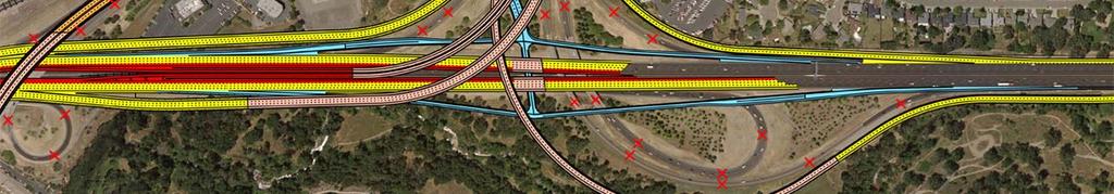
8 Stakeholder Focus Group Meeting #3 January 9, 2013 The three Build alternatives have common benefits that include adding additional travel lanes to I 80, SR 65, and the I 80/SR 65 interchange ramps. The types of lanes added include carpool lanes for high occupancy vehicles (HOV), mixed flow lanes for all drivers, and auxiliary lanes for entering and exiting traffic. A new direct HOV ramp connection between SR 65 and I 80, and improvements to Taylor Road are also proposed. Stakeholder comments and questions on Alternatives 1, 2, and 3 included: Question: Once traffic analysis is done for all alternatives, will there be another stakeholder focus group meeting to share the results? o Project Team Response: The next stakeholder meeting will be held at the administrative draft of the environmental document, at that time the next generation of traffic analysis will be presented to stakeholders before the next public meeting. Alternative 4 Transportation System Management (TSM) This alternative proposes to provide TSM improvements on and adjacent to the freeways that are in lieu of widening the freeways and interchange ramps, while addressing the project goals. These include: Auxiliary lanes between interchanges to improve traffic operations Added HOV bypass lanes on appropriate interchange ramps Ramp metering (traffic signals) on appropriate interchange ramps Electronic Messaging signs to provide drive route information during periods of congestion Added transit, bicycle, and pedestrian facilities to improve traffic operations This alternative proposes to provide improved traffic operations within the project limits and on adjacent roadways without increasing the capacity of I 80, SR 65 and the I 80/SR 65 interchange. Stakeholder comments and questions on Alternative 4 included: Question: Can elements of the TSM alternative be combined with other alternatives? o Project Team Response: Yes, elements of the TSM are typically included in other alternatives. The TSM alternative is required as a part of the Environmental Document phase. If the problem could be easily fixed with just the TSM improvements, it would have already been done. Question: Is this project included in the Metropolitan Transportation Plan (MTP)? o Project Team Response: Yes. Question: How long is the Notice of Preparation (NOP) comment period open? Page 8 of 10
9 Stakeholder Focus Group Meeting #3 January 9, 2013 o Project Team Response: The comment period is open from January 2 through January 31. Stakeholders may submit their comments through the feedback form distributed at today s meeting, via to pctpa@pctpa.net, or online at Question: Does this project include additional benefits not related to relieving traffic congestion? o Project Team Response: Yes, additional benefits include improving public safety, increased economic development opportunities, and improved access to businesses. Question: Will the team be considering ways to mitigate negative impacts to Secret Ravine and/or improving the existing conditions of the Secret Ravine? o Project Team Response: The project will require that any negative impacts to Secret Ravine be mitigated. Potential impacts will be evaluated as part of the environmental documentation phase. Comment: Secret Ravine is an important local salmon habitat; this corridor has a significant negative impact on the Ravine, it will be important to show mitigation measures. Question: How far can the project progress with the available funding? o Project Team Response: Funds are available to complete this PA&ED process and begin final design of a first project phase. Savings from the I 80 Bottleneck Project will continue to be used for this project; the goal is to use the available funding to get a project that is ready for construction; a shelf ready project. Question: If funding were available to fund the project, how soon could it be built? o Project Team Response: If funding were available, the earliest phase 1 could be constructed would be about However funding availability could put that date out substantially. A majority of future STIP funding to PCTPA was put into constructing the Lincoln Bypass project. But that does not mean funding could not come from other sources. Question: What is an approximate construction estimate for this project? o Project Team Response: The full project would be about $300 million, which is why it would be constructed in phases. Question: Will this project have a developer impact fee? o Project Team Response: That would be a Board decision, but most likely it would not. Question: Would this project be something that the Highway 65 Joint Powers Authority will look at? o Project Team Response: That is a possibility. Next Steps: Page 9 of 10
10 Stakeholder Focus Group Meeting #3 January 9, 2013 Community Workshop January 15 NOP comment period open until January 31, 2013 Next Stakeholder meeting fall/winter 2014 Page 10 of 10

11 STAKEHOLDER MEETING I-80 / SR 65 Interchange Improvements Project Wednesday, January 9 9:00 a.m. Cattlemens Restaurant 2000 Taylor Road, Roseville, CA The Placer County Transportation Planning Agency (PCTPA) along with the I-80/SR 65 interchange improvements project team would like to invite you to participate in a stakeholder meeting to discuss progress made in the evaluation of the project concepts and the upcoming environmental documentation phase. We anticipate the meeting should last no longer than 2 hours. We look forward to receiving your input. Please RSVP by Monday, January 7, 2013 by ing czanze@aimconsultingco.com or calling
12 STAKEHOLDER MEETING # 3 I 80 / SR 65 INTERCHANGE IMPROVEMENTS PROJECT APPROVAL & ENVIRONMENTAL DOCUMENT (PA&ED) PHASE JANUARY 9, 2013
13 Wl Welcome Introductions Background Agenda Where We ve Been & What s Ahead Concept Refinements Alternatives Moving Forward Environmental Studies Next Steps
14 Your Role Meeting attendance Bring community perspectives p to the project Provide input on project alternatives Where are existing traffic concerns? What access issues need to be considered? Where might properties be impacted? Communicate study progress and decisions


15 Project Partners PCTPA Caltrans Federal Highway Administration Placer County City of Roseville City of Rocklin City of Lincoln Project Team


 Design, Right of")
16 Background: Project Overview Study Area Project Phases Project Study Report (PSR) Project Approval & Environmental Document (PA&ED) Design, Right of Way, and Construction o
17 Goals and Objectives of the Project Reduce congestion Improve traffic operations and enhance safety Maintain community access Consider all travel modes and users
18 Congestion Efficiency Accessibility Safety Alternative Transportation Land duse Plans Draft Purpose & Need


19 Where We ve Been and What s Ahead Current PA&ED Phase


20 Where We ve Been Stakeholder and Community Workshops August 23 and April 14, 2011 January 11 and January 25, 2012 Today and January 15, 2013 Project Communications Website, Newspaper, Newsletters Aerial Mapping, Traffic Forecasts and Analyses 7 Concepts to 5 Project Alternatives Environmental Field Studies Notice of Preparation


21 Near Term Projects Considered SR 65 Northbound Restripe Add 3rd lane I 80 to Galleria I/C Incorporate as 1st Phase of interchange improvements I 80 Westbound Auxiliary Lane Add 5th lane, Riverside to Douglas Pursue as separate project
22 and What s Ahead Evaluate the Project Alternatives Perform Environmental Field & Technical Studies Prepare Draft Environmental Document & Project Report Hold Community and Stakeholder Workshops
23 Concepts Moving Forward As Alternatives Alternative 1 Taylor Road Full Access I/C (Diamond Shaped) Alternative 2 Taylor Road Full Access I/C (Trumpet Shaped) Alternative 3 Taylor Road Interchange Eliminated Alternative 4 Transportation System Management (TSM) Alternative 5 No Build (No Project)
24 Eliminated Concept Taylor Road Access Shifted Findings Less improvement to I 80 Traffic Operations than the other concepts Partial Interchange design not supported by agencies Benefits Improves interchange spacing Improves I 80 Weaving Maintains local access to Taylor Road Concerns Taylor Road is a partial interchange undesirable Limited access to local traffic
25 Eliminated Concept Antelope Creek Connection Findings Less improvement to I 80 Traffic Operations than the other concepts Costly Right of Way Acquisitions Benefits Adds parallel capacity on local street Concerns May change local traffic circulation patterns May impact local landfill, UPRR, Antelope Creek
26 Alternative 1 Taylor Road Full Access I/C (Diamond Shaped)


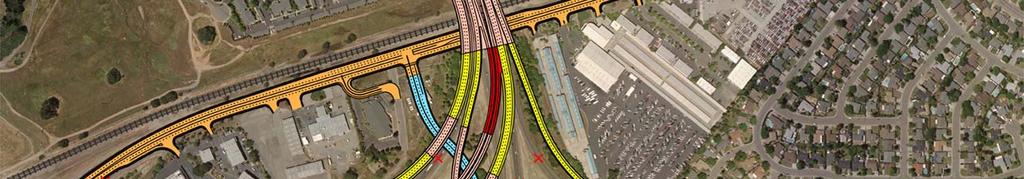


27 Alternative 1 Taylor Road Full Access I/C (Diamond Shaped) BENEFITS: Improves spacing between interchanges Diamond Interchange Improves traffic operations on I 80 Improves local access
28 Alternative 2 Taylor Road Full Access I/C (Trumpet Shaped)


29 Alternative 2 Taylor Road Full Access I/C (Trumpet Shaped) BENEFITS: Improves spacing between interchanges Trumpet Interchange Improves traffic operations on I 80 Improves local access
30 Alternative 3 Taylor Road Interchange Eliminated


31 Alternative 3 Taylor Road Interchange Eliminated Taylor Rd I/C Eliminated BENEFITS: Improves spacing between interchanges Improves traffic operations on I 80 CONCERNS: Reduces number of access connections Shifts local access to Eureka Rd, Galleria Blvd, ldand Rocklin Rd I/C s

")


32 Common Benefits of Alternatives 1, 2, & 3 Widen I 80 Add additional mixed flow lanes Add additional auxiliary lanes Widen SR 65 Add carpool/high occupancy vehicle (HOV) lanes Add additional mixed flow lanes Add additional auxiliary lanes Westbound From 6 to 7 Lanes Southbound From 3 to 5 Lanes Eastbound From 5 to 7 Lanes Northbound From 2 to 5 Lanes


33 Common Benefits of Alternatives 1, 2, & 3 I 80/SR 65 I/C Ramps Increase each ramp by one additional lane Improved design at existing EB to NB loop ramp South to West Ramp 3 Lanes East to North Ramp 3 Lanes West to North Ramp 2 Lanes South to East Ramp 2 Lanes


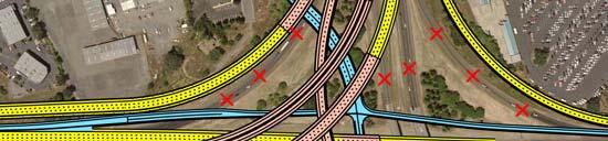


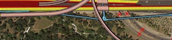


34 Common Benefits of Alternatives 1, 2, & 3 I 80/SR 65 I/C Carpool/HOV Connector Add HOV Ramp connection 1 lane in each direction Southbound SR 65 to Westbound I 80 1 Lane Eastbound I 80 to Northbound SR 65 1 Lane
35 Common Benefits of Alternatives 1, 2, & 3 Improve Taylor Road From 2 to 5 Lanes Remove the existing I 80/ Taylor Road I/C Ramps
36 Alternative 4 Transportation System Management Ramp Metering Mt (System and On/Off Ramps) HOV Bypass Lanes Changeable Message Signs (CMS) Traffic Signal Coordination Transit Options Bicycle and Pedestrian Facilities
37 Alternative 5 No Build (No Project) TheDo Nothing Alternative Existing Facilities and Conditions Remain Other Metropolitan Transportation ti Plan (MTP) Projects Required for Environmental Review


38 Environmental Studies Just Beginning! Assessing the project site conditions and alternatives Seeking Your Input Alternatives presented Areas of concerns Ideas or opportunities Any other items you see as important Support at the upcoming Public Meeting
39 Questions?
40 Next Steps Hold Public Scoping Meeting for the environmental document process Finalize Traffic Operational Analysis Preliminary Engineering of Alternatives Environmental Technical Studies Draft Environmental Document
STAKEHOLDER MEETING STANFORD RANCH ROAD/GALLERIA BOULEVARD/SR 65 NORTHBOUND RAMPS PROJECT APPROVAL & ENVIRONMENTAL DOCUMENT (PA&ED) PHASE
 PHASE") STAKEHOLDER MEETING STANFORD RANCH ROAD/GALLERIA BOULEVARD/ SR 65 NORTHBOUND RAMPS PROJECT APPROVAL & ENVIRONMENTAL DOCUMENT (PA&ED) PHASE January 12, 2016 Welcome and Introductions Meeting Goals I 80/SR
STAKEHOLDER MEETING STANFORD RANCH ROAD/GALLERIA BOULEVARD/ SR 65 NORTHBOUND RAMPS PROJECT APPROVAL & ENVIRONMENTAL DOCUMENT (PA&ED) PHASE January 12, 2016 Welcome and Introductions Meeting Goals I 80/SR
Keep Placer Moving. Placer is Growing. POPULATION (From 2014 to 2045) 70,000 new homes and well over 180,000 more residents
 70,000 new homes and well over 180,000 more residents") Keep Placer Moving Placer is Growing Keep Placer Moving POPULATION (From 2014 to 2045) 70,000 new homes and well over 180,000 more residents 30% of the total housing market growth in the Sacramento region.
Keep Placer Moving Placer is Growing Keep Placer Moving POPULATION (From 2014 to 2045) 70,000 new homes and well over 180,000 more residents 30% of the total housing market growth in the Sacramento region.
I-264 CORRIDOR EVALUATION STUDY. September 7, 2016 Eric Stringfield VDOT Planning Director Chris Lawrence AECOM Senior Transportation Engineer
 I-264 CORRIDOR EVALUATION STUDY September 7, 2016 Eric Stringfield VDOT Planning Director Chris Lawrence AECOM Senior Transportation Engineer Study Overview Interchange Locations Study Context Follow-up
7.0 FREEWAYS CONGESTION HOT SPOT PROBLEM & IMPROVEMENT PROJECT ANALYSIS & DEFINITION
 7.0 FREEWAYS CONGESTION HOT SPOT PROBLEM & IMPROVEMENT PROJECT ANALYSIS & DEFINITION 7.1 INTRODUCTION & METHODOLOGY FEASIBILITY REPORT Congestion hot spot problem locations have been assessed using the
INTRODUCTION. The focus of this study is to reduce congestion and improve mobility for all modes of transportation. Figure ES-1 Study Corridor Map
 INTRODUCTION The I-280 Corridor Study is a highway planning study led by Santa Clara VTA, in partnership with the City of Cupertino and in coordination with other stakeholders in the study area. The study
3.0 PROJECT DESCRIPTION
 The following section of the Draft EIR contains a description of the proposed Elk Grove Boulevard/SR 99 Interchange Modification project, consistent with the requirements of CEQA Guidelines Section 15124.
University Hill Transportation Study Technical Memorandum Alternatives Modeling and Analysis May 2007
 Technical Memorandum May 2007 Syracuse Metropolitan Transportation Council Edwards and Kelcey with Wallace Roberts and Todd Alta Planning and Design CONTENTS SECTION ONE- INTRODUCTION...1 SECTION TWO-
Los Altos Hills Town Council - June 18, 2015 Palo Alto City Council June 22, AGENDA ITEM #2.B Presentation
 Los Altos Hills Town Council - June 18, 2015 Palo Alto City Council June 22, 2015 AGENDA ITEM #2.B Presentation Previous Presentations Los Altos Hills Town Council in May 2014 and February 2015 Palo Alto
APPENDIX D: SACRAMENTO URBAN AREA TRANSPORTATION PRIORITIES
 1 County County County County 2 Yolo Arterial Roadway Collector Roadway Urban Residential Street Rural Residential Roadway I-80 / U.S. 50 Bus/Carpool Lanes in both directions Richards Blvd PM Yol 80 0.237
Appendix D: Concept Screening
 Concept Description Concept #1 Route 288 Roadway Widening This concept consists of constructing a third lane on northbound and southbound Route 288 between Powhite Parkway and US 360. This improvement
I-215 / NEWPORT ROAD INTERCHANGE PROJECT PRESS KIT
 I-215 / NEWPORT ROAD INTERCHANGE PROJECT PRESS KIT March I-215 / NEWPORT ROAD INTERCHANGE PROJECT Fact Sheet Project Overview This project will reconstruct the existing interchange located on Interstate
Municipal Class EA To Address Traffic Congestion On The Ontario Street Corridor (Grand Bend) Public Information Meeting June 4, 2018
 Public Information Meeting June 4, 2018") Municipal Class EA To Address Traffic Congestion On The Ontario Street Corridor (Grand Bend) Public Information Meeting June 4, 2018 Background Agenda Traffic Study Update Class EA Alternatives Bridge
Municipal Class EA To Address Traffic Congestion On The Ontario Street Corridor (Grand Bend) Public Information Meeting June 4, 2018 Background Agenda Traffic Study Update Class EA Alternatives Bridge
METHODOLOGY. Signalized Intersection Average Control Delay (sec/veh)
") Chapter 5 Traffic Analysis 5.1 SUMMARY US /West 6 th Street assumes a unique role in the Lawrence Douglas County transportation system. This principal arterial street currently conveys commuter traffic
Chapter 5 Traffic Analysis 5.1 SUMMARY US /West 6 th Street assumes a unique role in the Lawrence Douglas County transportation system. This principal arterial street currently conveys commuter traffic
I-20 ODESSA-MIDLAND CORRIDOR STUDY. Public Meeting for Schematic Design
 I-20 ODESSA-MIDLAND CORRIDOR STUDY Public Meeting for Schematic Design The environmental review, consultation, and other actions required by applicable Federal environmental laws for this project are being,
Highway 49, Highway 351 and Highway 91 Improvements Feasibility Study Craighead County
 Highway 49, Highway 351 and Highway 91 Improvements Feasibility Study Craighead County Executive Summary March 2015 Highway 49, Highway 351 and Highway 91 Improvements Feasibility Study Craighead County
ROUTES 55 / 42 / 676 BUS RAPID TRANSIT LOCALLY PREFERRED ALTERNATIVE
 ROUTES 55 / 42 / 676 BUS RAPID TRANSIT LOCALLY PREFERRED ALTERNATIVE April, 2012 1 INTRODUCTION The need for transit service improvements in the Routes 42/55/676 corridor was identified during the Southern
MoPac South: Impact on Cesar Chavez Street and the Downtown Network
 MoPac South: Impact on Cesar Chavez Street and the Downtown Network Prepared by: The University of Texas at Austin Center for Transportation Research Prepared for: Central Texas Regional Mobility Authority
Highway 217 Corridor Study. Phase I Overview Report
 Highway 217 Corridor Study Phase I Overview Report November 3, 24 BACKGROUND AND OVERVIEW Study purpose The Highway 217 Corridor Study is developing multi-modal transportation solutions for traffic problems
I-395 Express Lanes Northern Extension Project Crystal City Civic Association September 21, 2016
 I-395 Express Lanes Northern Extension Project Crystal City Civic Association September 21, 2016 Mike Snare, PE, Project Manager Virginia Department of Transportation GEC Michelle Holland, Megaprojects
Description: Widen I-64 to 6 lanes from I-265 to the KY 53 interchange in Shelby County.
 I-64 KIPDA ID # 350 Project Type: ROADWAY CAPACITY Description: Widen I-64 to 6 lanes from I-265 to the KY 53 interchange in Shelby County. Purpose: Project will improve capacity and address safety concerns.
Santa Clara I-280 CORRIDOR STUDY
 Santa Clara I-280 CORRIDOR STUDY OCTOBER 2017 PREPARED BY: 1.1 Background The I-280 Corridor Study within Santa Clara County is a high-level highway planning study led by the Santa Clara VTA, in partnership
Washington DC Section of ITE Project Briefing
 Washington DC Section of ITE Project Briefing November 5, 2015 Renée Hamilton, VDOT, Deputy District Administrator I-66 Outside the Beltway Improvement Area Project Location Virginia 2 Purpose and Need
Report Purpose To seek Council s approval of the Wye Road Functional Planning Study (January 2015).
.") COUNCIL MEETING Meeting Date: March 10, 2015 Agenda Item #: 13.1 Wye Road Functional Planning Study (January 2015) Report Purpose To seek Council s approval of the Wye Road Functional Planning Study (January
COUNCIL MEETING Meeting Date: March 10, 2015 Agenda Item #: 13.1 Wye Road Functional Planning Study (January 2015) Report Purpose To seek Council s approval of the Wye Road Functional Planning Study (January
Northwest Corridor Project Interchange Modification, Interchange Justification and System Analysis Report Reassessment (Phase I)
") Northwest Corridor Project Interchange Modification, Interchange Justification and System Analysis Report Reassessment (Phase I) Introduction The Georgia Department of Transportation (GDOT) prepared a
Northwest Corridor Project Interchange Modification, Interchange Justification and System Analysis Report Reassessment (Phase I) Introduction The Georgia Department of Transportation (GDOT) prepared a
Lee s Summit Road Improvement Study Public Open House June 7, 2007 Summary of Comment Card Responses
 Lee s Summit Road Improvement Study Public Open House June 7, 2007 Summary of Comment Card Responses Introduction At the Lee s Summit Road Improvement Study Public Open House held Thursday, June 7, 2007
EXHIBIT B. Bass Lake Rd US 50 to Hollow Oak Rd 2 Lanes with unimproved median and 4 foot paved shoulders. $ %
 Fee Program Project List - 2004 General Plan Cost Estimate 2004 Alternative Route Study West Valley Condition 27 Alternative connection between, Feasibility study. Included in /White Rock Connector. south
Traffic Circulation Study for Neighborhood Southwest of Mockingbird Lane and Airline Road, Highland Park, Texas
 ARIZONA TEXAS NEW MEXICO OKLAHOMA February 13, 2015 Mr. Meran Dadgostar P.E., R.S. Town of Highland Park 4700 Drexel Dr. Highland Park, Texas 75205 Re: Traffic Circulation Study for Neighborhood Southwest
Congestion Reducing Activities. Toby Carr GDOT Director of Planning April 10, 2014
 Congestion Reducing Activities Toby Carr GDOT Director of Planning April 10, 2014 GDOT Performance Dashboard Congestion Congestion Relief Strategies 511 HEROS RTOP Highway Emergency Response Operators
Foothill Expressway Improvements Between El Monte and San Antonio
 Foothill Expressway Improvements Between El Monte and San Antonio June 29, 2017 - Los Altos Community Meeting Introduction Project Background Agenda Visit Stations: Provide Input and Ask Questions Reconvene:
1. What is the Doran Street and Broadway/Brazil Grade Separation Project (Project)?
?") 1. What is the Doran Street and Broadway/Brazil Grade Separation Project (Project)? The Los Angeles County Metropolitan Transportation Authority (Metro) is evaluating the development of a grade separation
1. What is the Doran Street and Broadway/Brazil Grade Separation Project (Project)? The Los Angeles County Metropolitan Transportation Authority (Metro) is evaluating the development of a grade separation
Memorandum. Fund Allocation Fund Programming Policy/Legislation Plan/Study Capital Project Oversight/Delivery Budget/Finance Contract/Agreement Other:
 Memorandum Date: November 20, 2017 To: Transportation Authority Board From: Eric Cordoba Deputy Director Capital Projects Subject: 12/5/17 Board Meeting: San Francisco Freeway Corridor Management Study
4. ENVIRONMENTAL IMPACT ANALYSIS 9. TRANSPORTATION AND TRAFFIC
 4. ENVIRONMENTAL IMPACT ANALYSIS 9. TRANSPORTATION AND TRAFFIC 4.9.1 INTRODUCTION The following section addresses the Proposed Project s impact on transportation and traffic based on the Traffic Study
BOSTON REGION METROPOLITAN PLANNING ORGANIZATION MEMORANDUM. DATE June 2, 2011
 BOSTON METROPOLITAN PLANNING ORGANIZATION State Transportation Building Ten Park Plaza, Suite 2150 Boston, MA 02116-3968 Tel. (617) 973-7100 Fax (617) 973-8855 TTY (617) 973-7089 www.bostonmpo.org Jeffrey
CHAPTER 3 STUDY AREA OPERATIONAL OVERVIEW
 HPTER 3 STUY RE OPERTIONL OVERVIEW This chapter describes the overall traffic operations within the study area under existing and future conditions and focuses on individual intersections not directly
FM #: ETDM #: 11241
 SR 826/Palmetto Expressway PD&E Study From SR 93/I 75 to the Golden Glades Interchange FM #: 418423 1 22 01 ETDM #: 11241 Agency/ Kick Off Meeting October 27, 2011 2 Location Map From SR 93/I 75 to Golden
MnPASS System Today and the Future
 MnPASS System Today and the Future April 2010 By Nick Thompson Minnesota Department of Transportation Topics Minnesota s Current and Future MnPASS High Occupancy Toll Systems Overview of the MnPASS System
WEST AND SOUTH WEST RING ROAD DOWNSTREAM TRAFFIC IMPACTS
 Page 1 of 9 EXECUTIVE SUMMARY Alberta Transportation ( AT ) is preparing to construct the final sections of the Calgary Ring Road. This includes the South West Ring Road ( SWRR ) (from Lott Creek Blvd
M-58 HIGHWAY ACCESS MANAGEMENT STUDY Mullen Road to Bel-Ray Boulevard. Prepared for CITY OF BELTON. May 2016
 M-58 HIGHWAY ACCESS MANAGEMENT STUDY Prepared for CITY OF BELTON By May 2016 Introduction Missouri State Highway 58 (M-58 Highway) is a major commercial corridor in the City of Belton. As development has
122 Avenue: 107 Street to Fort Road
 : 107 Street to Fort Road November 24, 2015 4:30 8:00 p.m. Meeting Purpose Summarize project work completed to date Share results of public input from Phase 1 Share the draft concept plan and proposed
Circulation in Elk Grove includes: Motor vehicles, including cars and trucks
 Circulation, as it is used in this General Plan, refers to the many ways people and goods move from place to place in Elk Grove and the region. Circulation in Elk Grove includes: Motor vehicles, including
MOUNTAIN HOUSE SPECIFIC PLAN I 9.1 INTRODUCTION ASSUMPTIONS TRANSPORTATION FACILITIES TRANSPORTATION IMPROVEMENTS PHASING 9.
 CHAPTER NINE: TRANSPORTATION AND CIRCULATION 9.1 INTRODUCTION 9.1 9.2 ASSUMPTIONS 9.1 9.3 TRANSPORTATION FACILITIES 9.1 9.4 TRANSPORTATION IMPROVEMENTS PHASING 9.3 LIST OF FIGURES LIST OF TABLES Figure
Brian McHugh, Buckhead Community Improvement District. SUBJECT: Wieuca Road at Phipps Boulevard Intersection Improvements Project
 MEMO TO: FROM: Brian McHugh, Buckhead Community Improvement District Jagan Kaja, AICP, WSP Parsons Brinckerhoff SUBJECT: Wieuca Road at Phipps Boulevard Intersection Improvements Project DATE: October
CITY OF SPOKANE VALLEY Request for Council Action
 CITY OF SPOKANE VALLEY Request for Council Action Meeting Date: December 16, 2014 Department Director Approval: Check all that apply: consent old business new business public hearing information admin.
Preliminary Review of the T-REX Southeast Corridor Highway and Light Rail Transit Project
 Preliminary Review of the T-REX Southeast Corridor Highway and Light Rail Transit Project DRCOG Congestion Mitigation Program White Paper 07-1 (February 16, 2007) On time and under budget! Festivities
Basalt Creek Transportation Refinement Plan Recommendations
 Basalt Creek Transportation Refinement Plan Recommendations Introduction The Basalt Creek transportation planning effort analyzed future transportation conditions and evaluated alternative strategies for
Memorandum. Sunday, July 13, Saturday, July 19, 2014
 Memorandum To: David Lowin, Brooklyn Bridge Park Corporation From: Daniel Schack, AICP, PTP Date: Re: Brooklyn Bridge Park Pier 5/6 Loop Road Traffic Study Project No: 14-01-2407 At the request of Brooklyn
2014/2015 BIKE ROUTE PLAN 83 AVENUE PROTECTED BIKE LANE
 About the Project 2014/2015 BIKE ROUTE PLAN The City of Edmonton is planning a major bike route on the south side of Edmonton. This bike route is one part of a plan to provide citizens with transportation
I-395 Express Lanes Northern Extension Project Public Hearings
 I-395 Express Lanes Northern Extension Project Public Hearings Susan Shaw, PE, Megaprojects Director Virginia Department of Transportation Amanda Baxter, Special Projects Manager Virginia Department of
Abrams Associates. Transportation Impact Analysis. City of Rocklin. Prepared for: David Mohlenbrok City of Rocklin 4081 Alvis Court Rocklin, CA 95677
 Transportation Impact Analysis Sierra College Boulevard Commercial Project City of Rocklin Prepared for: David Mohlenbrok City of Rocklin 081 Alvis Court Rocklin, CA 95677 Prepared by: 1875 Olympic Boulevard,
Institute for Real Estate Management Chapter (IREM) 77 VDOT Northern Virginia Megaprojects September 13, 2017
 77 VDOT Northern Virginia Megaprojects September 13, 2017") Institute for Real Estate Management Chapter (IREM) 77 VDOT Northern Virginia Megaprojects September 13, 2017 Susan Shaw, P.E., Megaprojects Director Virginia Department of Transportation Northern Virginia
Institute for Real Estate Management Chapter (IREM) 77 VDOT Northern Virginia Megaprojects September 13, 2017 Susan Shaw, P.E., Megaprojects Director Virginia Department of Transportation Northern Virginia
I-395 Express Lanes Northern Extension Project Fairlington Citizens Association September 12, 2016
 I-395 Express Lanes Northern Extension Project Fairlington Citizens Association September 12, 2016 Susan Shaw, PE, Megaprojects Director, Virginia Department of Transportation Amanda Baxter, Special Projects
Clay Street Bridge Replacement Project
 Clay Street Bridge Replacement Project Frequently Asked Questions (FAQs) The project is located in downtown Placerville on Clay Street between US Highway 50 and Main Street and Cedar Ravine Road. The proposed
Detailed Description of Work
 Trail Items I-580 Eastbound Shoulder Running Lane and Bi-Directional Bike Lane Project Bay Area Toll Authority Task Order Contract with HNTB Corporation Effective May 12, 2014 Description of Work: Implement
PRESENTATION OUTLINE
 November 8, 2017 PRESENTATION OUTLINE Regional Express Lanes Network Purpose/Benefits of Express Lanes 95 Express Phase 3C Project Video and Overview 95 Express Phase 3C Schedule 2 SOUTH FLORIDA REGIONAL
Terwillegar Drive Expressway Draft Concept Plan
 Terwillegar Drive Expressway Draft Concept Plan Anthony Henday Drive to Whitemud Drive November 28 5:00-8:00 p.m. December 1 10:00 a.m. - 3:00 p.m. Let s Talk Today you can: Learn about the new direction
COMMUNITY WORKSHOP (CW) 3 February 21, 2015
 3 February 21, 2015") QEW Improvements QEW Improvements COMMUNITY WORKSHOP (CW) 3 February 21, 2015 1 WORKSHOP PURPOSE MOVING FORWARD Review of Technically Preferred alternative Seeking feed back for progressing to next design
QEW Improvements QEW Improvements COMMUNITY WORKSHOP (CW) 3 February 21, 2015 1 WORKSHOP PURPOSE MOVING FORWARD Review of Technically Preferred alternative Seeking feed back for progressing to next design
Appendix C. NORTH METRO STATION AREA TRAFFIC IMPACT STATEMENT 88th Avenue Station
 Appendix C NORTH METRO STATION AREA TRAFFIC IMPACT STATEMENT 88th Avenue Station Prepared for: Regional Transportation Department and URS Corporation as part of the North Metro EIS David Evans and Associates,
Preliminary Transportation Analysis
 Preliminary Transportation Analysis Goals of a Robust, Multimodal Transportation Network Safe Accessible/Connected Efficient Comfortable Context-Sensitive Motor Vehicle: Continue to analyze the data to
Please find below the Town staff s responses to NCDOT s recommended roadway stipulations listed in a letter dated May 25, 2015.
 TOWN OF CHAPEL HILL Public Works Department 6850 Millhouse Road Chapel Hill, NC 27516-8173 phone (919) 969-5100 fax (919) 969-2003 www.townofchapelhill.org TO: FROM: Chuck Edwards, NCDOT Division 7 District
# Southeastern Wisconsin Regional Freeway System Reconstruction Study and Preliminary Recommended Plan
 #70421 Southeastern Wisconsin Regional Freeway System Reconstruction Study and Preliminary Recommended Plan Public Information Meetings and Hearings May June 2002 1 Reason for Freeway System Study 270-mile
Interstate Route 77 / US Route 62 / State Route 687 (Fulton Road) Transportation Improvement Project. Prepared September 6, 2017
 Transportation Improvement Project. Prepared September 6, 2017") EODOT Project: ODOT Project: STA-IR 77-.50; PID 00290 Interstate Route 77 / US Route 62 / State Route 687 (Fulton Road) Transportation Improvement Project Summary of Public Comments Received and Responses
EODOT Project: ODOT Project: STA-IR 77-.50; PID 00290 Interstate Route 77 / US Route 62 / State Route 687 (Fulton Road) Transportation Improvement Project Summary of Public Comments Received and Responses
BETHEL ROAD AND SEDGWICK ROAD CORRIDOR STUDY
 DRAFT PLAN City Council Meeting August 14, 2017 STUDY AREA Sedgwick Corridor State Route 160, principal arterial with Class 3 access management designation, commuter and freight route, connection to SR
I-90 ALLSTON INTERCHANGE A MULTIMODAL TRANSPORTATION PROJECT MEPA CONSULTATION MEETING NOVEMBER 20, 2014 BRIGHTON HIGH SCHOOL
 I-90 ALLSTON INTERCHANGE A MULTIMODAL TRANSPORTATION PROJECT MEPA CONSULTATION MEETING NOVEMBER 20, 2014 BRIGHTON HIGH SCHOOL Today s Agenda 1. 2. 3. 4. 5. Overview of the MEPA Process Project Overview
Stakeholder Representative Group Meeting #2 Summary
 Summary The project team members present at the second Whitelock Parkway SR 99 Interchange Project Stakeholder Meeting included: Alan Glen, Quincy Engineering Brent Lemon, Quincy Engineering Jason Jurrens,
Public Meeting #1 Comment Summary
 Public Meeting #1 Comment Summary This summary includes comments received on comment forms and during conversations between attendees and project team staff at the February 18, 2016 public open house.
TRAFFIC IMPACT STUDY COMPREHENSIVE UPDATE TOWN OF THOMPSON S STATION, TENNESSEE PREPARED FOR: THE TOWN OF THOMPSON S STATION
 TRAFFIC IMPACT STUDY COMPREHENSIVE UPDATE TOWN OF THOMPSON S STATION, TENNESSEE PREPARED FOR: THE TOWN OF THOMPSON S STATION Transportation Consultants, LLC 1101 17 TH AVENUE SOUTH NASHVILLE, TN 37212
Port Mann/Highway 1 Improvements
 Port Mann/Highway 1 Improvements McGill St. Hastings St. First Ave. Port Coquitlam Boundary Rd. Willingdon Ave. Grandview Hwy. Sprott St. Kensington Ave. Gaglardi Way Brunette Ave. Cape Horn Port Mann
Corporate. Report COUNCIL DATE: June 26, 2006 NO: C012 COUNCIL-IN-COMMITTEE. TO: Mayor & Council DATE: June 22, 2006
 Corporate NO: C012 Report COUNCIL DATE: June 26, 2006 COUNCIL-IN-COMMITTEE TO: Mayor & Council DATE: June 22, 2006 FROM: General Manager, Engineering FILE: 0410-20(MoT/Gate) SUBJECT: Surrey Response on
Harrah s Station Square Casino
 Transportation Analysis Harrah s Station Square Casino Pittsburgh, Pennsylvania Submitted To: City of Pittsburgh and Pennsylvania Gaming Control Board Prepared By: DKS Associates GAI Consultants December
Northbound San Jose Avenue & I-280 Off-Ramp Road Diet Pilot Project
 Project Overview Fed by a two-lane Interstate-280 (I-280) off-ramp, high vehicular volumes and speeds are longstanding issues along San Jose Avenue. Residents in the surrounding neighborhoods have expressed
EXECUTIVE SUMMARY... vii 1 STUDY OVERVIEW Study Scope Study Area Study Objectives
 Contents EXECUTIVE SUMMARY... vii 1 STUDY OVERVIEW... 1-1 1.1 Study Scope... 1-1 1.2 Study Area... 1-1 1.3 Study Objectives... 1-3 2 EXISTING CONDITIONS... 2-1 2.1 Existing Freeway Conditions... 2-4 2.1.1
LSC TRANSPORTATION CONSULTANTS, INC. 516 North Tejon Street Colorado Springs, CO (719) FAX (719)
 FAX (719)") LSC TRANSPORTATION CONSULTANTS, INC. 516 North Tejon Street Colorado Springs, CO 80903 (719) 633-2868 FAX (719) 633-5430 E-mail: lsc@lsccs.com May 15, 2009 Mr. Davis Farrar Western Slope Consulting, LLC
LSC TRANSPORTATION CONSULTANTS, INC. 516 North Tejon Street Colorado Springs, CO 80903 (719) 633-2868 FAX (719) 633-5430 E-mail: lsc@lsccs.com May 15, 2009 Mr. Davis Farrar Western Slope Consulting, LLC
Interstate 66 Tier 1 Environmental Impact Statement (EIS)
") WELCOME Welcome to the second Citizen Information Meeting for the Tier 1 Environmental Impact Statement (EIS). As an integral part in the environmental study process, the study team is seeking your comments
WELCOME Welcome to the second Citizen Information Meeting for the Tier 1 Environmental Impact Statement (EIS). As an integral part in the environmental study process, the study team is seeking your comments
BD RESOLUTION NO RESOLUTION ADOPTING THE VISION ZERO RAMP INTERSECTION STUDY PHASE 1
 BD00 RESOLUTION NO. - RESOLUTION ADOPTING THE VISION ZERO RAMP INTERSECTION STUDY PHASE [NTIP PLANNING] FINAL REPORT WHEREAS, The Vision Zero Ramp Intersection Study Phase was recommended by Commissioner
Environmental Assessment Findings & Recommendations. Public Hearing November 13, 2014
 Environmental Assessment Findings & Recommendations Public Hearing November 13, 2014 Welcome! Welcome and Introductions Project and Environmental Assessment Overview Public Comments Adjourn Purpose of
INNOVATIVE INTERSECTION DESIGN
 INNOVATIVE INTERSECTION DESIGN J. Eddie Valtier, P.E. ELP TP&D Director Introduction Why Do We Need To Start Looking For Innovative Intersection Designs? Congestion is worsening and traffic volumes and
2014/2015 BIKE ROUTE PLAN 83 AVENUE PROTECTED BIKE LANE
 About the Project The City of Edmonton is planning a major bike route on the southside of Edmonton. The Strathcona Bike Route will connect the communities of Strathcona, Garneau and the University area,
Welcome. Thank you for your interest in the Lewis & Clark Viaduct Concept Study
 Welcome Thank you for your interest in the Lewis & Clark Viaduct Concept Study Please use the arrows in the upper left hand corner to navigate through the presentation. Use the envelope icon to ask a question
Station 1: Street & Sidewalk Upgrades
 Station 1: Street & Sidewalk Upgrades Existing no left turn; Potential left turn arrow, see Circulation Study boards for more information Thru-lane guidance Improved lead-in green bike lane 17TH ST CASTRO
HIGHBURY AVENUE/HAMILTON ROAD INTERSECTION IMPROVEMENTS PUBLIC INFORMATION CENTRE 1 MAY 14, 2015
 HIGHBURY AVENUE/HAMILTON ROAD INTERSECTION IMPROVEMENTS Municipal Class Environmental Assessment PUBLIC INFORMATION CENTRE 1 MAY 14, 2015 ACCESSIBILITY Under the Accessibility Standards 2015 for Customer
CHAPTER 2G. PREFERENTIAL AND MANAGED LANE SIGNS
 2011 Edition - Revision 2 Page 275 Section 2G.01 Scope CHAPTER 2G. PREFERENTIAL AND MANAGED LANE SIGNS 01 Preferential lanes are lanes designated for special traffic uses such as high-occupancy vehicles
REVIEW OF LOCAL TRAFFIC FLOW / LONG RANGE PLANNING SOLUTIONS STUDY
 ITEM Town of Atherton TRANSPORTATION COMMITTEE STAFF REPORT TO: FROM: MEMBERS OF THE COMMITTEE ROBERT OVADIA, PUBLIC WORKS DIRECTOR DATE: FEBRUARY 12, 2019 SUBJECT: REVIEW OF LOCAL TRAFFIC FLOW / LONG
APPENDIX E Evaluation of Improvement Alternatives
 APPENDIX E Evaluation of Improvement Alternatives Table E-1 Preliminary Comparison of Design Alternatives, Concord Table E-2 Preliminary Comparison of Route 2 Improvement Packages, Acton and Concord TABLE
EXHIBIT B-1 PROJECT DESCRIPTION. Phase 1 of the Preferred Alternative
 EXHIBIT B-1 PROJECT DESCRIPTION Phase 1 of the Preferred Alternative The Transform 66 Public-Private Partnership (P3) Project (the Project ) means the Phase 1 of the Preferred Alternative components of
INNOVATIVE INTERSECTION SOLUTIONS. Jay Bockisch, PE, PTOE Senior Associate
 INNOVATIVE INTERSECTION SOLUTIONS Jay Bockisch, PE, PTOE Senior Associate INNOVATIVE INTERSECTION SOLUTIONS Innovative intersection overview Case studies Continuous flow intersection Modern roundabouts
3.16 TRANSPORTATION, CIRCULATION, AND PARKING Regulatory Setting Environmental Setting ROADWAY SYSTEM
 3.16 TRANSPORTATION, CIRCULATION, AND PARKING This section assesses the potential for implementation of the Orchard Park Redevelopment component of the 2018 LRDP to result in impacts related to transportation,
MEMORANDUM. David Mohlenbrok, Environmental Services Manager
 MEMORANDUM DATE: August 10, 2017 TO: FROM: RE: Planning Commission Members David Mohlenbrok, Environmental Services Manager Blue Memo # 1 for Rocklin Station Project Comments Received on Initial Study/Mitigated
Bluffdale South (SR140) Bicycle/Shoulder Lanes Project Type Bicycle
 Bicycle/Shoulder Lanes Project Type Bicycle") Bluffdale 14600 South (SR140) Bicycle/Shoulder Lanes Project Type Bicycle From Pony Express to UPRR Bridge over SR-140 $ 669,700 $ 624,361 To build bicycle/shoulder lanes on SR-140. SR-140 is an official
Bluffdale 14600 South (SR140) Bicycle/Shoulder Lanes Project Type Bicycle From Pony Express to UPRR Bridge over SR-140 $ 669,700 $ 624,361 To build bicycle/shoulder lanes on SR-140. SR-140 is an official
CHIEF PEGUIS TRAIL EXTENSION WEST
 1 PRELIMINARY DESIGN OF THE CHIEF PEGUIS TRAIL EXTENSION WEST Public Information Session June 6, 2017 Welcome 1 Thank you for attending today s public information session. The following boards provide
Reference number /VP. Lafayette Downtown Congestion Study - Additional Traffic Analysis
 To James Hinkamp and Tony Coe, City of Lafayette Date January 19, 2017 Copies Reference number 243381/VP From Michael Iswalt and Vanessa Peers File reference 4-05 Subject Lafayette Downtown Congestion
APPENDIX G: INTERSECTION NEEDS AT OKEECHOBEE BOULEVARD
 APPENDIX G: INTERSECTION NEEDS AT OKEECHOBEE BOULEVARD INTERSECTION NEEDS AT SR 7 and OKEECHOBEE BOULEVARD SR 7 Extension Project Development and Environment (PD&E) Study From Okeechobee Boulevard (SR
3.0 Future Conditions
 3.0 Future Conditions In order to be able to recommend appropriate improvements to the transportation system of the Town, it is important to first understand the nature and volume of traffic that is expected
TABLE TRAFFIC ANALYSIS SCENARIOS
 4.11 TRANSPORTATION The potential traffic impacts of the proposed project are evaluated in the Buena Park Beach/Orangethorpe Mixed Use Project Traffic Analysis (Traffic Analysis) by Austin-Foust Associates
Thank you for attending
 Improving mobility safety comfort WELCOME Thank you for attending The purpose of this meeting is to: Learn about the project Prioritize potential walking and biking improvements on Snelling Ave Gather
APPENDIX D. May 22, 2002 Open House Summary and Materials
 APPENDIX D May 22, 2002 Open House Summary and Materials TH 36 Partnership Study Open House May 22, 2002 Summary of Survey Responses 1. If no new crossing of the St. Croix River is built (e.g. the existing
EXECUTIVE SUMMARY OF CALEDON TRANSPORTATION NEEDS STUDY
 EXECUTIVE SUMMARY OF CALEDON TRANSPORTATION NEEDS STUDY The Caledon Transportation Needs Study has been undertaken as a joint project by the Town of Caledon and the Region of Peel to determine the existing
Highway 169 Mobility Study Technical Advisory Committee Meeting #9 Meeting Record
 Highway 169 Mobility Study Technical Advisory Committee Meeting #9 Meeting Record Thursday, May 25, 2017 8:30-10:30 a.m. City of Eden Prairie Heritage Rooms I and II Attendees Brad Larsen, MnDOT Angie
Fairfax County Parkway Widening Fairfax County
 Get Involved VDOT representatives will review and evaluate information received as a result of this meeting. Please fill out the comment sheet provided in this brochure if you have any comments or questions.
TECHNICAL MEMORANDUM
 TECHNICAL MEMORANDUM DATE: January 17, 2005 TO: Ted Idlof, URS FROM: Jeff Clark, Fehr & Peers RE: U.S. 50 Interchange Planning Study 1042-2011 This memorandum describes conceptual improvements for the
Albany Shaker Road Corridor Study Public Meeting # 2
 Albany Shaker Road Corridor Study Public Meeting # 2 Scope / Meeting Purpose This project is a CDTC Linkage Study. The Linkage Program is designed to implement the adopted planning and investment principles