Cruising Map. Main Line (Restoration Proposed) Crumlin Arm (Restoration Proposed) Newport and River Usk. including. Route 75M3 Map Issue
|
|
|
- Toby Job Shields
- 5 years ago
- Views:
Transcription


1 Cruising Map of the Monmouth & Brecon Canal (Restoration Sections) including Main Line () () Newport and River Usk Route 75M3 Map Issue 50 60
2 Notes 1. The information is believed to be correct at the time of publication but changes are frequently made on the waterways and you should check before relying on this information. 2. We do not update the maps for short term changes such as winter lock closures for maintenance. 3. The information is provides as is and the Information Provider excludes all representations, warranties, obligations, and liabilities in relation to the Information to the maximum extent permitted by law. The Information Provider is not liable for any errors or omissions in the Information and shall not be liable for any loss, injury or damage of any kind caused by its use.
 10.20m (33'6\") Three Locks (3) 9.")
 52 51 50 58 57 56 55 54 53 49 44 Upper Pontnewydd Maendy Way 43 Woodside Footbridge 42 Clomendy (Farm)")
 Ty-Coch Top Lock 46 4.07m (13'4\") 45 3.71m (12'2\") Rachels Lock 44 39 Ty-Coch 38 Hollybush Way 37 3.")
 Ty-Coch Bottom Lock 40 3.71m (12'2\") Tredegar Lock 39 36 Lower Ty-Coch 35 Tredegar Lock 3.")
3 MAB 12 MAB 11 M 24h W Limit of Navigation 63 Staircase Cross Keys Locks (5) 14.89m (48'10") M 24h 0.0K 0.0M 0L 0B 0.0H 45 Cross Keys MAB 12 MAB 11 Pontnewydd Locks (3) 10.20m (33'6") Three Locks (3) 9.91m (32'6") Forge Hammer Locks (4) 13.73m (45'1") Upper Pontnewydd Maendy Way 43 Woodside Footbridge 42 Clomendy (Farm) GKN 41 Halfway 40C 40B 40A Two Locks (2) 6.92m (22'8") Two Locks Aqueduct 3.25m (10'8") Ty-Coch Top Lock m (13'4") m (12'2") Rachels Lock Ty-Coch 38 Hollybush Way m (11'0") Brake Lock m (12'2") Shop Lock m (12'0") Lower Brake Lock m (13'0") Ty-Coch Bottom Lock m (12'2") Tredegar Lock Lower Ty-Coch 35 Tredegar Lock 3.81m (12'6") Drapers (Cider Mill) Lock m (11'9") Tamplin Lock Cider Mill 33 Wheatsheaf 32 Ash Tree 31 Malpas Court MAB Tyfynnon Lock 4.07m (13'4") 30 Tyfynnon MAB 12


")

4 MAB MAB 13 Abandoned 22 Cwmcarn Lock Aqueduct 18 Pontywaun 17 Green Meadow 16 Darran Possible aqueduct required for restoration 15 Navigation 14 Pen-y-Rhiw 13 Moriah (Chapel) 12 Gelli Pistyll Removed Giles Aqueduct Tyn-y-Cwm 11 MAB 13 MAB 13

 Fourteen Locks Visitor Centre Potter Street Lock 21 Staircase 19-20 Staircase 17-18 Staircase 15-16 5")
5 MAB 12 Tyn-y-Cwm 11 MAB Harry Roberts Pont-y-Mason 9 8 Great Oak 7 Meeting House i 6A Ruskin Avenue Visitor Centre Open daily 10:00-16:30 Cwm Lane, Rogerstone, NP10 9GN Cefn Fourteen Locks (14) 47.86m (157'0") Fourteen Locks Visitor Centre Potter Street Lock 21 Staircase Staircase Staircase Pensarn Staircase Staircase Staircase 8-9 M4 Motorway i 7 Cwrt-y-Mwnws Lock 3.60m (11'10") 4 Cwrt-y-Mwnws
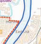
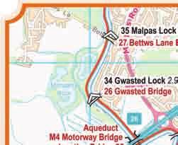
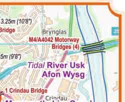
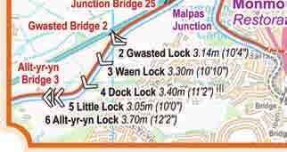
 26 Gwasted M4/A4042 Motorway s (4) Tidal River Usk Railway Aqueduct M4 Motorway Junction 25 Gwasted 2 Malpas Junction 1 Crindau Allt-yr-yn 3 2 Gwasted Lock 3.14m (10'4\") 3 Waen Lock 3.")
6 31 Malpas Court 36 Tyfynnon Lock 4.07m (13'4") 30 Tyfynnon MAB 12! Lift 29 Lift 28 Holly Bush 35 Malpas Lock 3.25m (10'8") 27 Bettws Lane 34 Gwasted Lock 2.95m (9'8") 26 Gwasted M4/A4042 Motorway s (4) Tidal River Usk Railway Aqueduct M4 Motorway Junction 25 Gwasted 2 Malpas Junction 1 Crindau Allt-yr-yn 3 2 Gwasted Lock 3.14m (10'4") 3 Waen Lock 3.30m (10'10") 4 Dock Lock 3.40m (11'2") 5 Little Lock 3.05m (10'0") 6 Allt-yr-yn Lock 3.70m (12'2") 7 Cwrt-y-Mwnws Lock 3.60m (11'10") 4 Cwrt-y-Mwnws Lock 1 Abandoned Railway Newport Railway Newport Footbridge MAB 16 George Street A48! Transporter Transporter


7 MAB 16 George Street MAB 16 A48! Transporter Transporter SEVERN 01 SEVERN 01 SEVERN 02 MAB 16 MAB 16

8 Waterway Routes Maps and DVDs covering the canals and rivers of Britain Ideal for Planning your holiday Showing family and friends where you have been Thank you, birthday and Christmas gifts. Complete 01 England & Wales Rings 82 South Pennine 83 Cheshire 84 Four Counties 85 Black Country 86 East Midlands 87 Warwickshire 88 Stourport 89 Birmingham Mini 90 Avon 91 Mid Worcestershire Canals and Rivers 09 Lancaster 10 Leeds & Liverpool 11 Rochdale 12 Huddersfield 13 Aire & Calder and Calder & Hebble 14 River Ouse and Tributaries 15 Sheffield & South Yorkshire 17 Chesterfield 18 Fossdyke & Witham and Tributaries 19 Grantham 20 River Trent 23 Manchester Ship and River Mersey 24 River Weaver 25 water 26 Ashton and Peak Forest 27 Macclesfield 28 Trent & Mersey 30 Caldon 31 Shrewsbury and Newport Canals 32 Shropshire Union 33 Llangollen 34 Montgomery 35 Staffs & Worcester 38 BCN 40 Birmingham & Fazeley 41 Droitwich 42 Worcester & Birmingham 43 River Severn and G&S 44 River Avon (Stratford) 45 Stratford upon Avon 46 Coventry 47 Ashby 49 Grand Union (Leicester) 50 Grand Union (All) 51 Grand Union (North) 52 Grand Union (South) 53 Oxford 54 Wilts & Berks 55 Cotswold 56 Kennet & Avon 57 Herefordshire & Gloucestershire 58 River Thames (Upper) 59 River Thames (Lower) 60 River Thames (All) 61 River Wey and Basingstoke 63 Lee & Stort Navigations 65 Rivers Welland, Glen and Fens Link 66 River Nene 67 Middle Level Navigations 68 River Great Ouse and Tributaries 70 Forth & Clyde and Union 75 Monmouth & Brecon
9 Waterway Information Waterway Monmouth & Brecon Canal Section Maximum Length Maximum Width All 19.74m (64 9 ) 2.79m (9 2 ) Speed Limit 6.4 kph (4 mph) Navigation Authority CRT(9) CRT (9) CRT HQ Canal & River Trust South Wales & Severn The Dock Office, Commercial Road, Gloucester, GL1 2EB Canal & River Trust Headquarters First Floor North, Station House, 500 Elder Gate, Milton Keynes, MK9 1BB Navigation Authority Phone: enquiries.southwalessevern@canalrivertrust.org.uk Web: Phone: customer.services@canalrivertrust.org.uk Web: DVDs Look out for our great range of DVDs to provide more information for planning your journey. Popular Like a television programme following a cruise along the waterway Bowcam A forward facing camera, running all the time, and speeded up for a little fun. Combined Both Popular and Bowcam in one box saving money on the DVDs (and the postage) See the whole range on our website at
 Un-navigable - Abandoned - Dry Un-navigable - Abandoned - Wet Un-navigable - Abandoned - Tunnel Un-navigable - - Dry Un-navigable - - Wet Un-navigable - - Tunnel")
 Walkable Linking Path (elsewhere) Cyclable Towpath (alongside waterway) Cyclable Towpath in Tunnel Cyclable Other Path (where no towpath) Cyclable Linking Path (elsewhere)")

10 SYMBOLS WATER Navigable - Tidal Navigable - River Navigable - Canal Navigable - Canal in Tunnel Winding Point (full length for navigation unless marked) No Winding / No Acute Angle Turn (use next winding point and return) Un-navigable - Abandoned - Dry Un-navigable - Abandoned - Wet Un-navigable - Abandoned - Tunnel Un-navigable - - Dry Un-navigable - - Wet Un-navigable - - Tunnel Un-navigable - Proposed New - Dry Un-navigable - Proposed New - Wet Un-navigable - Proposed New - Tunnel TOWPATH Walkable Towpath (alongside waterway) Walkable Towpath in Tunnel Walkable Other Path (where no towpath) Walkable Linking Path (elsewhere) Cyclable Towpath (alongside waterway) Cyclable Towpath in Tunnel Cyclable Other Path (where no towpath) Cyclable Linking Path (elsewhere) Un-walkable Towpath - Abandoned Un-walkable Towpath in Tunnel - Abandoned Un-walkable Towpath - Un-walkable Towpath in Tunnel - Un-walkable Towpath - Proposed New Un-walkable Towpath in Tunnel - Proposed New LOCKS etc. Navigable Lock Navigable Lock (circle indicates control side) Navigable Lock (with tail bridge) Navigable Lock (paired) Navigable Lock (staircase) Un-navigable Lock - Abandoned Un-navigable Lock - Un-navigable Lock - Proposed New Guillotine Gate (on detailed insets) Guillotine Gate (circle indicates control side - on detailed insets) Weir BRIDGES etc. B B Boatyard or Marina - Business C Chandlery D Diesel E G G Elsan Emptying H H Hire Base - Weekly / Weekend P Pump Out R R Refuse Disposal S T Shower W i Water! Navigation Advice (see message box)! Swing M M 7d M 24h M Area Limit M 2d (7d) Navigation Advice (see symbol text) M Mooring designated for disabled boaters M pay Mooring with payment required M patrons M overnight Mooring for patrons (of pub, restaurant etc.) M ask lock keeper Mooring only with lock keeper's permission M FOTRN Moorings for members of Friends of the River Nene only (on River Nene) M GOBA M M 72h Moorings for members of Great Ouse Boating Association only (on River Great Ouse and tributaries) Boatyard or Marina - Trust / Society Gas - Calor Gas - Not Calor Hire Base - Day Recycling Point Toilet Information (see message box) 2 - Existing - Removed - Proposed New - Towpath Pipe Tunnel Aqueduct Building (over canal) Mooring - Signed - Maximum 14 days Mooring - Maximum days as specified Mooring - Maximum hours as specified Mooring Area Limits (see message box) Moorings in designated Mooring Area - Maximum days in summer (winter in brackets) Mooring Overnight Only Mooring - Unsigned but appears suitable - Maximum 14 days Mooring - Unsigned but appears suitable - Maximum hours as specified mph Speed Limit (miles per hour and kilometers per hour) applicable to side of sign shown 4.8 kph Information Bars 7.2K 4.5M 3L 1B 2.5H Regular ½ hour spacing 9.0K 5.6M 3L 1B 2.8H Additional Information based on a zero point (which is usually at one end of the waterway) K = Kilometres from the zero point M = Miles from the zero point L = Number of Locks from zero point B = Number of s which are moveable (lift, swing etc.) from zero point (normally left closed and low enough to require opening for a narrow boat) H = Number of hours cruising from zero point OTHER Ferry Wires (may require lowering for navigation) Access Point (to towpath) Point of Interest KEY for Waterway Routes Maps NOTES 1. It is the colour of the symbol (not the text) which identifies Existing (black) / Abandoned (grey) / New (red) 2. Services at Boatyards and Marinas will usually require payment. They may be discounted or free for residents. 3. The number of hours cruising time cannot be precise and should only be used for an indication of journey time. No allowance is made for queuing for locks, which may happen, especially in the summer. No allowance is made for stops for water, shopping, meals, etc. Travelling upstream on a river or the Llangollen Canal will be slower, while travelling downstream may be a little quicker. Paul Balmer trading as WATERWAY ROUTES Available to download in Memory-Map (qct) and Acrobat (pdf) formats 10 Bude Close Nailsea Bristol BS48 2FQ Contains Ordnance Survey data Crown Copyright and database right Phone: info@waterwayroutes.co.uk Web: All other work Waterway Routes
PUBLISHED FOR COMMENT ON ACCURACY
 CRAFT DIMENSIONS This document gives current maximum craft dimensions for all waterways managed by British Waterways. Each waterway is listed in alphabetical order note that River navigations are indexed
The Role of the Canal & River Trust Fisheries & Angling Team
 The Role of the Canal & River Trust Fisheries & Angling Team Britain s Canals Arteries of the world s first Industrial Revolution Most built 1770-1850 up to 4,000 miles at their peak Shaped British society,
RE-PRICING OF 12 MONTH MOORING PERMITS 2015 MOORINGS AREA REPORT FOR GLOUCESTERSHIRE & WORCESTERSHIRE
 RE-PRICING OF 12 MONTH MOORING PERMITS 2015 MOORINGS AREA REPORT FOR GLOUCESTERSHIRE & WORCESTERSHIRE Introduction This report provides the rationale for mooring price decisions for 2015. VAT is payable
The Role of the Canal & River Trust Fisheries & Angling Team
 The Role of the Canal & River Trust Fisheries & Angling Team Britain s Canals Arteries of the world s first Industrial Revolution Most built 1770-1850 up to 4,000 miles at their peak Shaped British society,
Canals. All About. These notes are designed to help you with homework and other projects. canalriverexplorers.org.uk
 All About Canals These notes are designed to help you with homework and other projects. It will help you to discover: how canals are different from rivers why canals were built who built canals and when
Queen Elizabeth Olympic Park Skipper s Guide
 Queen Elizabeth Olympic Park Skipper s Guide BACKGROUND AND HISTORY Known as the Bow Back Rivers, this historic network of waterways was transformed in the build up to the London 2012 Olympic and Paralympic
WINDING HOLES towards a specification for the ideal turning place
 WINDING HOLES towards a specification for the ideal turning place Introduction The term winding hole is normal in the narrow canal network, and on adjoining broad canals, for a space in which to turn a
Topics covered. File location/file Name (including version)/author Initials/Support Initials/Date
/author Initials/Support Initials/Date") Boat Owners Survey Topics covered Key performance measures General upkeep and performance Customer service (including licence renewal) Use of boats Boater demographics and views Mooring (home and residential)
Boat Owners Survey Topics covered Key performance measures General upkeep and performance Customer service (including licence renewal) Use of boats Boater demographics and views Mooring (home and residential)
CONSULTATION ON TOWPATH MOORING PLAN FOR THE KENNET & AVON CANAL WEST OF DEVIZES
 CONSULTATION ON TOWPATH MOORING PLAN FOR THE KENNET & AVON CANAL WEST OF DEVIZES 30 August 29 November 2013 Introduction The Canal & River Trust and Kennet and Avon (K&A) Waterways Partnership are seeking
RE-PRICING OF 12 MONTH MOORING PERMITS 2015 MARKET AREA REPORT FOR HUMBER TO THE WASH
 RE-PRICING OF 12 MONTH MOORING PERMITS 2015 MARKET AREA REPORT FOR HUMBER TO THE WASH Introduction This report provides the rationale for mooring price decisions for 2015. VAT is payable at the rate set
UNION CANAL CARRIERS LTD. Holiday Boat Hire
 UNION CANAL CARRIERS LTD www.unioncanalcarriers.co.uk Holiday Boat Hire Welcome Aboard Introduction Union Canal Carriers aims to set standards that few hire fleets can match. Because we are as enthusiastic
Ilkeston s Centenary Journey Press Pack
 100 years on Ilkeston s Centenary Journey Press Pack 2 nd edition Ilkeston, Horse Boat, 1912-2012 Ilkeston is a composite, horse-drawn, narrow boat, built in 1912 by Braithwaite and Kirk of West Bromwich
The group discussed the draft proposal and agreed the following recommendations.
 NOTES e Title K&A review of Visitor Moorings (west) Date Wednesday 25 February 2015 Venue Attendees Canal & River Trust Office, Devizes Present, Nick Worthington, Matthew Symonds, Dale Marshall (Canal
WELCOME TO THE MILLENNIUM RIBBLE LINK
 WELCOME TO THE MILLENNIUM RIBBLE LINK The prestigious 5.8m project to construct the Millennium Ribble Link opened in 2002. This is the first new navigation to be built in England since the Manchester Ship
River and Canal Maps
 River and Canal Maps for Trent Adventure Trent Adventure Base at Poplars Farm Twyford Road Twyford Barrow or Trent DE73 7HJ 07876 751 599 28-Apr-2015 2015 Trent Adventure - Version 3p4 1 Trent and Mersey
Hawkesbury Canal Junction. (Sutton Stop) Near Coventry.
 Near Coventry.") Hawkesbury Canal Junction. (Sutton Stop) Near Coventry. Starts at Hawkesbury Canal Junction,Blackhorse Road,Bedworth 1 hours 49 minutes 5.5miles 8.9km Leisurely ID: 0.1798 Developed by: Peter Hopewell
Hawkesbury Canal Junction. (Sutton Stop) Near Coventry. Starts at Hawkesbury Canal Junction,Blackhorse Road,Bedworth 1 hours 49 minutes 5.5miles 8.9km Leisurely ID: 0.1798 Developed by: Peter Hopewell
Atherstone and return from Rugby
 UK Canal Boating UK Canal Boating Escape with a canal boating holiday! Telephone : 01395 443545 Email : contact@ukcanalboating.com Booking Office : PO Box 57, Budleigh Salterton. Devon. EX9 7ZN. England.
Highways England Creative M Welcome. Smart motorway M6 junctions 16 to 19 public information exhibition
 Welcome Smart motorway junctions 16 to 19 public information exhibition Smart motorway junctions 16 to 19 Making the motorway better The is also part of the Highways England strategic road network connecting
SINGLE LONG TERM MOORING AGAINST PRIVATE RESIDENTIAL LAND
 SINGLE LONG TERM MOORING AGAINST PRIVATE RESIDENTIAL LAND The Canal & River Trust is the owner of the canal bed and permission is needed for the exclusive right to occupy water space as a home mooring.
Bingley Five Rise Locks
 Five Rise On the Leeds & Liverpool Canal www.canalrivertrust.org.uk Engineering Challenges & Solutions The canal engineers used the latest techniques to overcome the challenges of the landscape. There
UPPER THAMES WW GUIDE TO THE
 WW GUIDE TO THE Leave the gin palaces of the Royal River far behind, and enjoy the blissful peace of the Thames through rural Oxfordshire. Keith Goss is your guide UPPER THAMES Idyllic scene at Kelmscott.
Staffordshire and Worcestershire Canal
 UK Canal Boating UK Canal Boating Escape with a canal boating holiday! Telephone : 01395 443545 Email : bookings@ukcanalboating.com Booking Office : PO Box 57, Budleigh Salterton. Devon. EX9 7ZN. England.
Standedge Tunnel Customer Guidelines
 Standedge Tunnel Customer Guidelines Canal & River Trust operate a chaperoned system of through trips for Standedge Tunnel. This means that you will be able to steer your own boat, under your own power,
Welcome. Smart motorway M1 junctions 13 to 16 public information exhibition. Highways England Creative [XXXXX_XXXX_XXX]
![Welcome. Smart motorway M1 junctions 13 to 16 public information exhibition. Highways England Creative [XXXXX_XXXX_XXX]](/thumbs/95/124397560.jpg "Welcome. Smart motorway M1 junctions 13 to 16 public information exhibition. Highways England Creative [XXXXX_XXXX_XXX]") Welcome Smart motorway junctions 13 to 16 public information exhibition Smart motorways Smart motorways are a technology driven approach to the use of our motorways, increasing capacity and relieving congestion
Welcome Smart motorway junctions 13 to 16 public information exhibition Smart motorways Smart motorways are a technology driven approach to the use of our motorways, increasing capacity and relieving congestion
There are toilets at Manningtree Station, Flatford (close to the hump back bridge) and in Dedham.
 and in Dedham.") Arriving by Train Main Features of the Walk Outline Route Employs particularly attractive paths, many of which offer impressive views across Dedham Vale. Includes a section along the tidal section of the
Arriving by Train Main Features of the Walk Outline Route Employs particularly attractive paths, many of which offer impressive views across Dedham Vale. Includes a section along the tidal section of the
WOLVERHAMPTON BOAT CLUB MOORING REGULATIONS
 Mooring Regulations Page 1 of 6 WOLVERHAMPTON BOAT CLUB MOORING REGULATIONS For the purposes of these regulations, the Moorer shall be the registered owner of the boat, or in their absence, the person
A mainly flat walk along the Peak Forest Canal to Castle Hill and returning along the River Tame via Hulmes Wood and Haughton Dale.
 Walk 9 Haughton Green, Peak Forest Canal, Castle Hill, Hulmes Wood, River Tame, Haughton Dale Circular Miles: 3.9 Time: 1 Hour 30 Minutes Grade: Easy To Moderate Starting Point: Junction Of Gibraltar Lane/Newport
Upgrade to smart motorway Junctions 13 to 16
 Upgrade to smart motorway Junctions 13 to 16 Junctions 13 to 16 About smart motorways Public information exhibitions We are improving the busy 37.9 km (23.6 miles) stretch of the between Junction 13, just
Birmingham and return from Worcester
 UK Canal Boating UK Canal Boating Escape with a canal boating holiday! Telephone : 01395 443545 Email : contact@ukcanalboating.com Booking Office : PO Box 57, Budleigh Salterton. Devon. EX9 7ZN. England.
ENVIRONMENT AGENCY WATER RESOURCES ACT 1991
 ENVIRONMENT AGENCY WATER RESOURCES ACT 1991 FISH REMOVAL (ROD and LINE) BYELAWS The Environment Agency, in exercise of powers conferred on it under section 210 of, and paragraph 6(1)(b) of Schedule 25
TOWPATH WALK. Fold out map. inside! Revealing Oldknow s Legacy GUIDE & MAP MARPLE & MELLOR. oldknows.com
 2 TOWPATH WALK Fold out map inside! 3 4 Revealing Oldknow s Legacy GUIDE & MAP & MELLOR oldknows.com and the Peak Forest Canal in Marple SAMUEL OLDKNOW Samuel Oldknow, a Lancashire born muslin manufacturer,
John Selby suggests Boat Builders Sketchbook by Keith Kealy 1993 as source material
 N&Q 27.18 Contract for building a canal boat in 1836 Hugh Conway-Jones asks I would be interested to hear comments on the following document from the Gloucester Waterways Museum collection that was brought
Dorridge & District Residents Association A Walk Along The Green Belt From Dorridge to Catherine-de-Barnes
 Dorridge & District Residents Association A Walk Along The Green Belt From Dorridge to Carine-de-Barnes The starting section of this walk through open fields would be destroyed by building of motorway
London Assembly Investigation into Waterway Moorings
 Campaigning for the use, maintenance, and restoration of Britain s inland waterways London Assembly Investigation into Waterway Moorings Introduction The Inland Waterways Association (IWA) welcomes the
Welcome. Smart motorway M6 junctions 13 to 15 public information exhibition. Highways England Creative BHM18_0060_RHK
 Welcome Smart motorway M6 junctions 13 to 15 public information exhibition Smart motorways Smart motorways are a technology driven approach to the use of our motorways, increasing capacity and relieving
Boat Owners Survey April 2016
 Boat Owners Survey 2016 April 2016 Introduction and methodology Background Objective is to refresh the Canal & River Trust s understanding of the experiences, opinion, behaviours and preferences of licenced
Route Summary. Start Directions. Distance: 12 miles to Lancaster or 8 miles to Galgate. Approximate Time: 3-5 Hours
 Lancaster Canal, Garstang to Lancaster Easy Trail: Please be aware that the grading of this trail was set according to normal water levels and conditions. Weather and water level/conditions can change
Where to find us: Travelling by Car to Better Boating
 Where to find us: Travelling by Car to Better Boating Ten minutes before you arrive, please phone or text us on 07780 88 71 72 and we will come straight away and meet you in the car park and take you to
Route Summary. Start and Finish Directions. Distance: 7 miles for an out and back trip to St Catherine s Lock Approximate Time: Time 3-5 Hours
 River Wey Guildford to St Catherine s Lock Moderate Trail: Please be aware that the grading of this trail was set according to normal water levels and conditions. Weather and water level/conditions can
To Let by Informal Tender FISHING RIGHTS. Situated near. Great Haywood and Milford in. Staffordshire. Tender Deadline
 To Let by Informal Tender FISHING RIGHTS Situated near Great Haywood and Milford in Staffordshire Tender Deadline FRIDAY 8 November 2013 AT 12.00 NOON 12 STAFFORD STREET ECCLESHALL STAFFORDSHIRE ST21 6BH
The Highways Agency is working to improve the M1 between junction 28 (near Alfreton) and junction 35a (the A616 Stocksbridge bypass).
 and junction 35a (the A616 Stocksbridge bypass).") Welcome The Highways Agency is working to improve the M1 between junction 28 (near Alfreton) and junction 35a (the A616 Stocksbridge bypass). The M1 is a vital part of the strategic road network, connecting
Welcome The Highways Agency is working to improve the M1 between junction 28 (near Alfreton) and junction 35a (the A616 Stocksbridge bypass). The M1 is a vital part of the strategic road network, connecting
WDAA Maps Directions & Special Rules
 WDAA Maps Directions & Special Rules Upper Weaver Lea Green Lane Head towards Church Minshull on Swanlow Lane from Winsford. Pass over narrow bridge crossing Ash Brook and through an S bend. Turn next
holly tree Wellhill Farm Woodyard Bramham House red kites Round House ha-ha
 This 6.4 mile walk around the magnificent Bramham Park Estate has been made possible with the active support of the owner of the Estate, Nick Lane Fox, with funding from Natural England, as part of Defra
The magazine of the Furness Vale Boat Club. February 2017
 Reflections The magazine of the Furness Vale Boat Club February 2017 Introduction. Welcome to the February 2017 edition of Reflections the periodical magazine of the Furness Vale Boat Club. In this article
London to Oxford Trek map
 London to Oxford Trek map Route stats: 103.6 km (64.4 miles) with 800 metres of climbing Start time: 08:00-09:00 Checkpoints: Start - Spelthorne Leisure Centre TW18 1AJ Distance: 0km (0m) Leave here by:
Welcome What can London s Waterways do for your local area? - Transforming Places - Making the most of the waterspace - Who s on London s Boats?
 Welcome What can London s Waterways do for your local area? - Transforming Places - Making the most of the waterspace - Who s on London s Boats? - Working in Partnership Break (including 2 minutes silence)
Lincolnshire Walks. Grainthorpe. Three circular walks of 2 ¾, 9 and 9 ½ km (1 ¾, 5 ½ and 6 miles)
") Lincolnshire Walks Grainthorpe Three circular walks of ¾, 9 and 9 ½ km (1 ¾, ½ and 6 miles) Introduction Explore the coastal marshes, arable hinterland, Louth Navigation canal and the village of Grainthorpe
Lincolnshire Walks Grainthorpe Three circular walks of ¾, 9 and 9 ½ km (1 ¾, ½ and 6 miles) Introduction Explore the coastal marshes, arable hinterland, Louth Navigation canal and the village of Grainthorpe
Nearest Town: Guildford Start and Finish: Riverside Road, Bellfields, Guildford GU1 1LN. Local Facilities: In Guildford
 River Wey and Godalming Navigations- Guildford to Shalford Easy to Moderate Trail: Please be aware that the grading of this trail was set according to normal water levels and conditions. Weather and water
VELINDRE VALLEYS WALK FOR STEFFAN
 VELINDRE VALLEYS WALK FOR STEFFAN IMPORTANT INFORMATION FOR WALKERS AND MARSHALS 1 Table of Contents Key Contact Numbers:... 3 Timetable and locations... 4 T-shirts... 4 Important Advice for Walkers...
Avon Ring from Stourport on Severn
 UK Canal Boating UK Canal Boating Escape with a canal boating holiday! Telephone : 01395 443545 Email : contact@ukcanalboating.com Booking Office : PO Box 57, Budleigh Salterton. Devon. EX9 7ZN. England.
THIS IS NOT THE CAR PARK YOU WANT TO BE IN
 Starting your day Arriving by car Directions from Edinburgh Take the A8 for Glasgow and the West. At Newbridge roundabout take the M9 West for Stirling. Take the slip road off for Falkirk (Junction 5).
A52. Nottingham Junctions. Construction at Nottingham Road and Cropwell Road junctions commencing early January 2017
 Nottingham Junctions Construction at Nottingham Road and Cropwell Road junctions commencing early January 2017 Introduction The is the key east-west link across the East Midlands. The route is subject
Adagio Birmingham City Centre. Adagio Liverpool City Centre. Castle Hotel Windsor - MGallery by Sofitel
 H Code H8117 H8117 H7332 H7332 H6618 H7186 H6365 H6636 H5170 H7232 H7288 H6359 H2178 H1459 H3158 H6444 H5547 H6593 H6598 H5678 H6175 H6596 H8710 H3503 H9446 H6002 H6595 H3188 H3578 H6465 H8033 H6943 H6003
The Railway from Pill Junction to Portishead in March 2015
 The Railway from Pill Junction to Portishead in March 2015 A series of pictures taken to record the status of the old line following the major clearance operation Never assume you are safe on or near old
Inside: All you need to get started including your fun treasure hunt map! Fundraise together
 Inside: All you need to get started including your fun treasure hunt map! Fundraise together with the Canal & River Trust Let s work together Contents 1 Let s work together 2-3 Together we can raise vital
Torksey Lock Trail On the Fossdyke Canal
 Torksey Lock Trail On the Fossdyke Canal Start outside the Visitor Centre Torksey Lock Torksey Lock is built where the River Trent and the Fossdyke Canal meet. The River Trent is tidal, it has strong currents
Regional Spread of Inbound Tourism
 Regional Spread of Inbound Tourism Foresight issue 157 VisitBritain Research 1 Contents Introduction Summary Key metrics by UK area Analysis by UK area Summary of growth by UK area Scotland Wales North
Consultation paper for changes to Liverpool Link 2015 season
 Consultation paper for changes to Liverpool Link 2015 season After discussions with boaters we are considering changing the way that we manage the Leeds & Liverpool Canal from Hancock s Swing Bridge to
Truman Enterprise Narrowboat Trust Risk Assessment
 Rating Assessment Degree of (After) Arriving at the boatyard Who is at? Moving vehicles Bodily damage Passengers, Public Boat staff on hand upon arrival 5 1 5 Agreed procedure prior to arrival Agreed assembly
Key Information. Self-Guided Walk Exploring Sedbergh
 Self-Guided Walk Exploring Sedbergh A great short walk - ideal for an early evening in summer. This is a lovely circuit of Sedbergh visiting some of the historic buildings as well as ambling by the river
East Lulworth Ride Route 5
 East Lulworth Ride Route 5 Out of ar Experience - ycling in Purbeck ircular route from Wareham to Lulworth - 18 miles + Lulworth ove oombe Keynes River Frome Time needed: 3-4 hours + Grading: Moderate
Twenty-second Editon GUIDE TO INLAND BOATING. Canal Boatbuilders Association.
 GUIDE TO Twenty-second Editon INLAND BOATING Canal Boatbuilders Association www.thecba.org.uk Useful addresses BUY WITH CONFIDENCE The Canal Boatbuilders Association (CBA) is a trade association, representing
Parks Canada + Boating = A Beautiful Thing! Darlene Upton Parks Canada
 Parks Canada + Boating = A Beautiful Thing! Darlene Upton Parks Canada 1 5 NATIONAL PARKS 2 37 NATIONAL HISTORIC SITES 1 WORLD HERITAGE SITE NATIONAL URBAN PARK 2 3 The Parks Canada Boating Offer 4 Partners
M6 Junction 10 Public Consultation
 M6 Junction 10 Public Consultation December 2015 Introduction Walsall Council and Highways England are developing plans to provide a long term improvement to M6 junction 10. We are holding this non-statutory
Chichester Harbour. A Walker s Guide
 A Walker s Guide - Chichester Harbour Chichester Harbour A Walker s Guide Chichester Harbour is an Area of Outstanding Natural Beauty on the south coast of Britain. Virtually flat with far reaching sea
Rugby to Snarestone Ashby Canal
 Rugby to Snarestone Ashby Canal We fancy a nice quiet country route this time last trip we went to Edinburgh so more of a City Break this time we want peace and quiet and the smell of the country! Day
THE ROAD TO LONDON From Roman Baldock From Medieval Baldock From Tudor Baldock
 THE ROAD TO LONDON What would you say if I stopped you in the street and asked you the way to London? You d probably direct me to the roundabout by Tesco s, tell me to go up the hill along London Road
Green Man Ultra Route Directions 2018
 Green Man Ultra Route Directions 2018 Start-CP1 (9 miles) Community Forest Path (CFP) Frome Valley Way (FVW) From the starting line cross the playing fields diagonally to the metal gates in the hedge lined
connectivity through walking and cycling
 active design case study the national forest: connectivity through walking and cycling active design principles in action: 1. ACTIVITY FOR ALL 2. WALKABLE COMMUNITIES 3. CONNECTED WALKING & CYCLING ROUTES
UK & Ireland Winter offer Participating hotels
 UK & Ireland Winter offer 2016 - Participating hotels Hotel Name Etap Belfast ibis Aberdeen ibis budget Beaconsfield ibis budget Birmingham Airport ibis budget Birmingham Centre ibis budget Bradford ibis
Know your smart motorways M60/M62, Greater Manchester
 Know your smart motorways M/M62, Greater Manchester Manchester smart motorways: M junction 8 to M62 junction 20 The M and M62 are vital parts of the strategic road network in England. They provide an important
Walk Description. Directions
 Title: Saffron Trail: Battlesbridge to Chelmsford Distance: 14¾ miles Time taken: 6 hours Start Point: Outside the Barge Inn, Battlesbridge OS Explorer Map: 175 & 183 Grid Ref.: TQ 780 947 Transport: Rail:-
Upgrade to smart motorway Junctions 3 to 12
 Upgrade to smart motorway Junctions 3 to 12 Information exhibitions July 2018 About smart motorways Smart motorways are a technology All lane running driven approach to the use of our motorways, increasing
A Walk around Holmes Chapel starting & finishing at Holmes Chapel Railway Station. by Tony & Lindsay Wright (2016)
") A Walk around Holmes Chapel starting & finishing at Holmes Chapel Railway Station. by Tony & Lindsay Wright (2016) Introduction Holmes Chapel Railway Station is on the Crewe to Manchester line. The station
A Walk around Holmes Chapel starting & finishing at Holmes Chapel Railway Station. by Tony & Lindsay Wright (2016) Introduction Holmes Chapel Railway Station is on the Crewe to Manchester line. The station
For further advice and information, please contact the central enquiries desk. Redefine BDL Groups Desk T:
 For further advice and information, please contact the central enquiries desk Redefine BDL Groups Desk E:groups@redefinebdl.com T:0845 834 1126 Our Brands & s across the UK Redefine BDL s the UK s leading
British Waterways, South West Waterway Office: Harbour House, West Quay, The Docks, Gloucester GL1 2LG Tel or Fax
 NABO CRUISING NOTES GLOUCESTER & SHARPNESS CANAL Introduction The forms the navigable link between the River Severn at Gloucester and the tidal Severn estuary at Sharpness a distance of approximately 16
M6 J7 Rushall Canal: Essential Repair Work Briefing
 M6 J7 Rushall Canal: Essential Repair Work Briefing Highways England need to carry out essential repair work to the M6 northbound carriageway between junctions 7 and 8 to keep it in a safe condition. From
English Canoe Classics. twenty-eight great canoe & kayak trips. Vol. 2. south. Eddie Palmer & Nigel Wilford
 English Canoe Classics twenty-eight great canoe & kayak trips Vol. 2 south Eddie Palmer & Nigel Wilford VOLUME 1 NORTH Bideford Bay Tamar 21 20 Torridge 23 WALES 19 Taw Plymouth Exe 17 18 Taunton Exeter
Lincolnshire Walks. Ancaster. Three cir cular walks of2 3/4,4or 6km (11/3, 21/2 or 33/4 miles)
") Lincolnshire Walks Ancaster Three cir cular walks of2 3/4,4or 6km (11/3, 21/2 or 33/4 miles) Introduction These walks are set in the attractive countryside around the historic town of Ancaster. The town
Lincolnshire Walks Ancaster Three cir cular walks of2 3/4,4or 6km (11/3, 21/2 or 33/4 miles) Introduction These walks are set in the attractive countryside around the historic town of Ancaster. The town
Sandilands to Huttoft Bank
 Coastal Country Park Walks Sandilands to Huttoft Bank A CIRCULAR WALK OF 11KM (7 MILES) INTRODUCTION The Lincolnshire Coastal Country Park lies between Sandilands, Chapel St Leonards and Huttoft on the
River Tees Guidance Notes
 River Tees Guidance Notes Date Sept 15 Issue 00.00 Contents 1. Amendment Record 2. Introduction 3. Purpose of this Document 4. River Activities 5. River Events 6. River Access 7. Slipways & Launching 8.
2-3 miles - up to 90 minutes walks
 SHIREHAMPTON COMMUNITY ACTION FORUM Walkie-Talkies Issue 17 Free Walks Programme From January 2017, due to changes in the way that LinkAge operates, there will no longer be a Health Walks Coordinator in
Safe Sailing BASIC RULES
 BASIC RULES 1 As a general rule, keep right, as on the French roads, unless otherwise indicated. 2 Merchant vessels always have right of way over pleasure craft. 3 Craft should only cross where there is
Site Working Information Card: River Chess, Chesham Lawn Tennis and Squash club, Pednormead End, Chesham, Bucks HP5 2JU Grid Ref: SP
 Site Working Information Card: River Chess, Chesham Lawn Tennis and Squash club, Pednormead End, Chesham, Bucks HP5 2JU Grid Ref: SP 955 013 Chesham Lawn Tennis and Squash Club Pednormead End Chesham,
Tuesday 6 June 2017 Afternoon
 Oxford Cambridge and RSA F Tuesday 6 June 2017 Afternoon GCSE GEOGRAPHY A A732/01 Geographical Skills (Foundation Tier) *5820270462* Candidates answer on the Question Paper. OCR supplied materials: An
Cliveden Cross Country Sunday 7 January 2018, 9.00am Under UK Athletics Rules SEAA Race Permit
 Cliveden Cross Country Sunday 7 January 2018, 9.00am Under UK Athletics Rules SEAA Race Permit 2018 31623 Welcome to another post-christmas test of endurance and fitness at Cliveden presented by kind permission
The main feature of this tranquil walk is a visit to the source of the Thames (the Thames head) which is in a field just 3 km from Kemble station
 which is in a field just 3 km from Kemble station") SWC Walk DRAFT Kemble circular: the source of the River Thames. The main feature of this tranquil walk is a visit to the source of the Thames (the Thames head) which is in a field just 3 km from Kemble
SWC Walk DRAFT Kemble circular: the source of the River Thames. The main feature of this tranquil walk is a visit to the source of the Thames (the Thames head) which is in a field just 3 km from Kemble
Responses to Mooring properly your views Boaters Update 15 Jan 2016
 Responses to Mooring properly your views Boaters Update 15 Jan 2016 Sensible speed, if your boat is causing a wash on the banks then you are going too fast. Tick over in some situations does not provide
Lincolnshire Limewoods Walks. Woodhall Spa. A circular walk of 13km (8 miles)
") Lincolnshire Limewoods Walks Woodhall Spa A circular walk of 13km (8 miles) Introduction The Lincolnshire Limewoods is an area between Wragby, Bardney and Woodhall Spa. It is a fantastic place to explore
Lincolnshire Limewoods Walks Woodhall Spa A circular walk of 13km (8 miles) Introduction The Lincolnshire Limewoods is an area between Wragby, Bardney and Woodhall Spa. It is a fantastic place to explore
Smart motorway. M6 junctions 16 to 19
 Smart motorway junctions 16 to 19 Where is this smart motorway? Smart motorway junctions 16 to 19 A533 Nantwich 20 A533 A530 A534 Northwich A54 19 Middlewich Crewe A5020 Shawington 7 18 Sandbach A534 17
Dyrham and Hinton Parish Walks
 Dyrham and Hinton Parish Walks A series of five walks in the parish, exploring most of the public footpaths. By John Miller Each walk is described in detail, with a complete map, to provide a handy guide
The Hundred Parishes
 The Hundred Parishes Walks from railway stations number 9 6.4 miles (10kms) from Bishop s Stortford to Stansted Mountfitchet Start: Bishop s Stortford station (Grid Reference TL492209) (ample parking and
Thornton le Dale Walks
 Thornton le Dale Walks A collection of walks in and around the village Thornton le Dale Traders Forum www.visitthorntonledale.co.uk Thornton le Dale Walks Walk 1: Beck Isle Cottage and All Saints Church
Please see the enclosed Sponsorship Package information sheets which detail the various ways that you may wish to support our event.
 Dear Sir / Madam BURTON REGATTA Our event: Burton Regatta a spectacular competitive rowing event held annually in the East Midlands, organised by the two local rowing clubs and officiated by British Rowing.
Matt Mallinder, Cycling UK Dick Vincent, National Towpath Ranger. Living waterways transform places and enrich lives
 Matt Mallinder, Cycling UK Dick Vincent, National Towpath Ranger Living waterways transform places and enrich lives Cycling on Towpaths opportunities for Canal & River Trust Matt Mallinder Cycling UK Membership
1.1 This information note accompanies Transport for Greater Manchester s cycle map data released at:
 GM Cycle Map Data Supporting Information (July 2017) 1 Background 1.1 This information note accompanies Transport for Greater Manchester s cycle map data released at: https://data.gov.uk/dataset/gm-cycle-routes
River Severn Navigation
 River Severn Navigation User s Guide If you have received this book from a hire boat operator, please return it after your holiday so it can be used again. Contents Introduction Welcome 3 The history 3
Battle of Bosworth field. Circular walks around Leicestershire. Lin and John
 Battle of Bosworth field Lin and John A circular walk from Market Bosworth via Sutton Cheney, Battle of Boswoth Field, Shenton Steam Railway and the Ashby Canal Duration - 3½ to 4 hours Distance - 11 kilometres
Walk 3 - Woodbridge and Melton A Walk Round Waldringfield by Sue and Jim Stacey. Woodbridge. shopping centre, cafes, toilets etc. tide mill.
 Walk 3 - Woodbridge and Melton A Walk Round Waldringfield by Sue and Jim Stacey. road with roundabout church railway with station walk route showing description direction track, wide path, bridlepath footpath
10 km Circular 3 hours
 FRIMLEY AND FRIMLEY GREEN 10 km Circular 3 hours Easy Terrain 250716 A 10km (6 mile) circular walk exploring the canal towpath, riverside path, woodland, heath and small settlements around Frimley in Surrey.